
Abstract
S’Omu e S’Orku (SOMK) is a collapsed rock shelter on the western coast of Sardinia, with a 9500–7800 cal BP geoarchaeological stratigraphic sequence encompassing the 9.3 and the 8.2 ka climatic events of the early Holocene. Sardinia is quite remote from the Italian coast and from mainland Europe, without firm evidence of human peopling before the onset of the Holocene. The animal species of the time were very few, all of them endemic, with Prolagus sardus, an ochotonid the size of a hare, by far dominant in the SOMK record. More local resources were novel for newly arrived people, like obsidian for producing lithic artefacts, but after the evidence from SOMK at first, they adapted and soon developed elaborated burial customs. The 9.3 event was characterised by wildfires burning the landscaped and by the ensuing debris flows sweeping the rock shelter. Then, when the environment stabilised again, a burial provides evidence of more human presence. The 8.2 event is marked by more wildfires and debris flows, and then at SOMK there is no more archaeological record. The sea-level is known was rising, eroding and invading stretches of the coasts. The human groups do not seem to have overcome all the compounded challenges of a quickly changing environment.
Keywords
Introduction
Sardinia was the largest Mediterranean island when it was joined to Corsica during the LGM, forming the Sardo-Corsican massif. However, it was, as now, far away from the coasts of the Italian peninsula and of Europe as a whole. At the end of the Pleistocene only two sizeable terrestrial mammals species are recorded, both of them endemic ones: Cynotherium sardous, a small canid, and Praemegaceros cazioti, a small deer, which were accompanied by the ubiquitous Prolagus sardus, an ochotonid the size of a hare (Valenzuela et al., 2022). There are hints to human peopling at the time (Mussi, 2009; Mussi and Melis, 2002), but it is only in the early Holocene that archaeology is well assessed. The known sites, however, are just a handful, in Sardinia as in nearby Corsica (Lugliè, 2018), by then already two distinct islands. At S’Omu e S’Orku (SOMK) geoarchaeological research faced compounded problems, the outcome of processes fostered by climatic change: not only it is a coastal site, currently under erosion, but only a marginal part of the deposit is available for inspection and excavation, as most of it extends below a recent huge dune which obviously cannot be demolished.
This site now provides, together with archaeological data, information on the changes and natural hazards affecting the coastal area of Sardinia between ca. 9200 and 7800 years ago, after the dates provided below, when rising sea levels, wildfires, slope instability and crumbling rock shelter walls and roof impacted on the life of prehistoric human groups which left a substantial archaeological record. The evidence fits well with the wider scenario of abrupt environmental changes occurring in the Mediterranean area during the early Holocene (e.g. Alley and Agustsdottir, 2005; Berger and Guilaine, 2009; Jalut et al., 2000, 2009; Mayewski et al., 2004).
Study area and research history
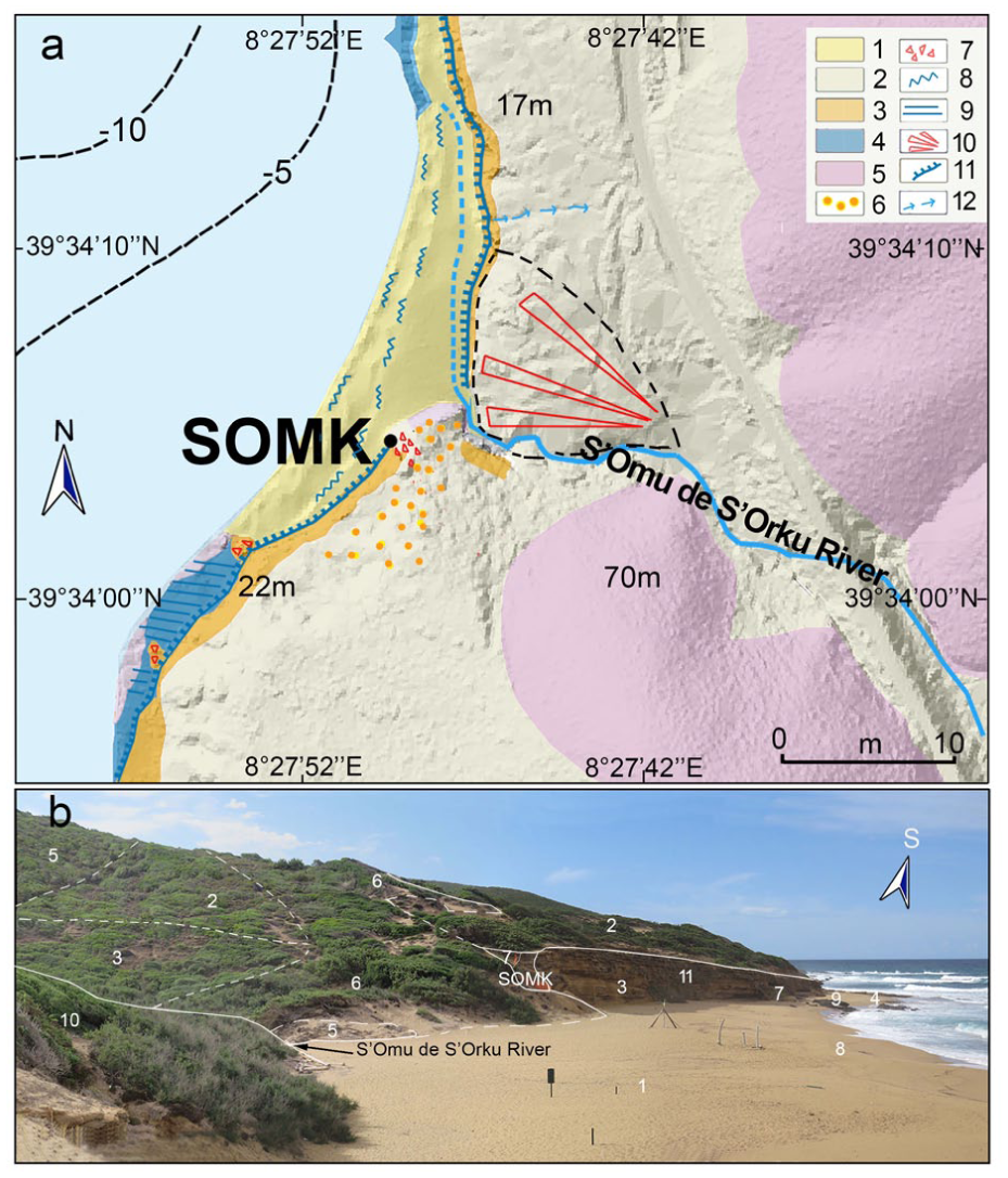
The SOMK site (39°34’05” N,, 8°27’36”E, 5 m asl), which directly faces a modern beach, is located south of Portu Maga, on the western coast of southern Sardinia (Arbus, SU; Figure 1(a)). It was a chance discovery by amateurs in 1985, when the ochrated remains of a skeleton, later labelled as SOMK1, were noticed eroding along the eolian cliff. The archaeological remains were stored at Guspini in a local museum organised by Gruppo Archeologico Neapolis. This did not attract attention until 2002, when the Soprintendenza Archeologica di Cagliari, in charge for the heritage of southern Sardinia, asked the two coauthors to start scientific research at the site. Regular excavation campaigns were held from 2011 to 2023.
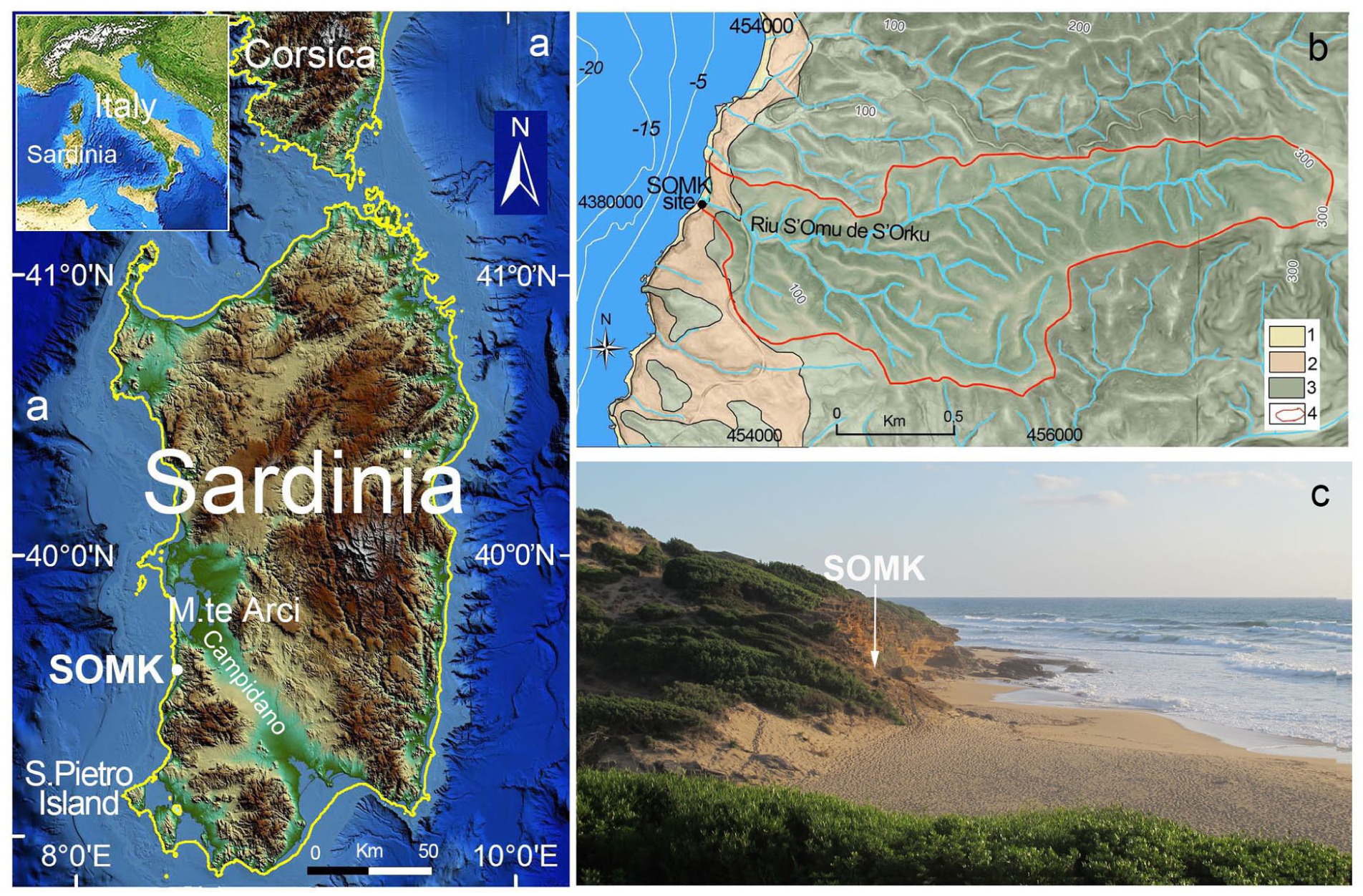
(a) Location of the S’Omu e S’Orku site; the yellow line indicates the paleocoastline at −20 m, corresponding to the time of the Mesolithic occupation, (b) schematic geological map of the study area and the hydrographic basin of the S’Omu de S’Orku River; (1) Holocene sandy beach sediments, (2) Pleistocene/Holocene eolian deposits, (3) Palaeozoic metamorphic substrate, (4) watershed boundary, and (c) view of the SOMK site area.
Currently the coast is characterised by cliffs and small bedrock promontories, sandy pocket beaches and coastal dunes. The inland landforms are moderate reliefs, up to 300 m high, incised by deep valleys on the Variscan metamorphic basement (Unità dell’Arburese; Carmignani et al., 2015; Figure 1(b)). In the study area, the substrate lithotypes are dominated by metasiltites and metargillites of the Upper-Middle Ordovician.
After the last interglacial the falling sea level led to the deposition of eolian dune bodies on the Palaeozoic basement and MIS5 littoral sediments (Melis et al., 2023).Then, during the early Holocene, the rapidly rising sea level triggered cliff formation on the eolianites (Melis et al., 2023). Progressive cliff retreat was facilitated by further marine erosion, by intense linear erosion of watercourses and rockfalls.
Next to the SOMK site the eolianite cliff is interrupted by the mouth of the S’Omu de S’Orku River, which today flows only seasonally but develops from a substantial hydrographic basin of 5000 km2 (Figure 1(b)). After heavy precipitations, the river flows eroding the large beach north of SOMK (Figure 2(d); see Supplemental Figure S1). Coarse alluvial sediments of Upper Pleistocene/early Holocene age crop out at the top of the eolianite cliff (Figure 2(c)) as well as on the red sandy paleosols along the left slope of the S’Omu de S’Orku (Supplemental Figure S2).
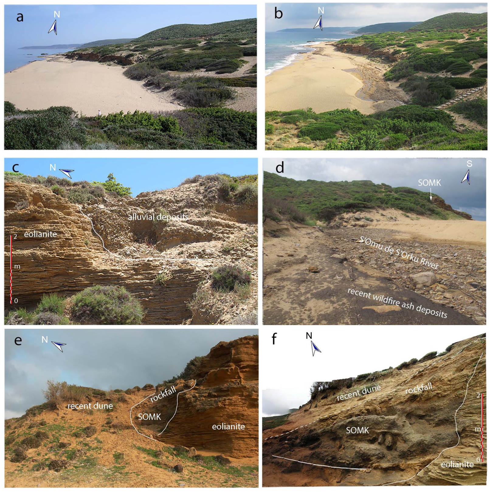
(a) View of the large beach north of the SOMK site and of the same area after heavy rainfall, showing active erosion by the S’Omu de S’Orku River, (b) and (c) coarse alluvial sediments of Upper Pleistocene/early Holocene age cropping out within an incision at the top of the eolianite cliff, (d) coarse alluvial deposits exposed in the channel of the S’Omu e S’Orku River after 2018 event, eroding the beach at north of SOMK. Interbedded with the coarse alluvial deposits, ash dark sediments represent slope wash deposits derived from post-fire erosion following wildfires in 1982 and 1985, (e) view of the SOMK site before the 2007 fieldwork, showing rockfall debris, debris flow deposits and recent eolian sediments, and (f) view of the SOMK site during the 2011 excavation campaign.
On the left side of the S’Omu de S’Orku valley, an erosional surface on the metamorphic bedrock possibly is a river terrace. It stands at the same height as the SOMK site and ancient alluvial deposits currently covered by eolian sediments and dense vegetation.
The climate is Mediterranean, with dry summers and mild and wet winters (ARPAS, 2025). Powerful Mistral winds, blowing from NW, seasonally hit the coast generating strong waves crashing on the beach and sometimes at the base of the SOMK site.
The coastal vegetation is a mediterranean maquis where a scrub composed mainly of mastic trees, brooms, strawberry trees and centuries-old junipers develops. No direct evidence of the local paleovegetation is available, but around 8000 cal BP and following centuries Erica arborea and E. scoparia stands dominated the landscape of the northern coast of Sardinia at both lake Baratz and Stagno di Sa Curcurica, as well as in the Posada coastal plain (Beffa et al., 2016; Melis et al., 2018; Michelangeli et al., 2025; Pedrotta et al., 2021). The pollen core of Lac de Creno in Corsica further suggests that these species and a maquis vegetation were well established in the coastal areas of the island since de beginning of the Holocene (Reille et al., 1999e). During the early Holocene, as will be discussed below, we surmise a similar environment further south around SOMK on the western coast of Sardinia.
Materials and methods
Geological geomorphological surveys
Geomorphological investigation was achieved by field survey and remote sensing analysis. In 2011–2024 field surveys were carried out yearly in spring and autumn in collaboration with researchers of Università di Cagliari. The remote sensing survey was carried out through the interpretation of multi-temporal aerial photos for years 1954–2019 (Regione Sardegna, 2017). Digital terrain models (LIDAR data of 1 m cell size; Regione Sardegna, 2017) were used. A lithostratigraphic field description was conducted on sequences exposed along the coast and the Omu de S’Orku river.
Thin section micromorphology
The micromorphological analysis provides information on depositional, post-depositional and taphonomical processes as well as on human activities. It was performed on thin sections prepared from undisturbed sediment blocks by Servizi per la Geologia, Piombino, Italy. We conducted the analysis with a Zeiss Axio Imager petrographic microscope under plane-polarised (PPL) and cross-polarised (XPL) light. The description of the thin sections follows Courty et al. (1989) and Stoops (2021).
Radiocarbon dating
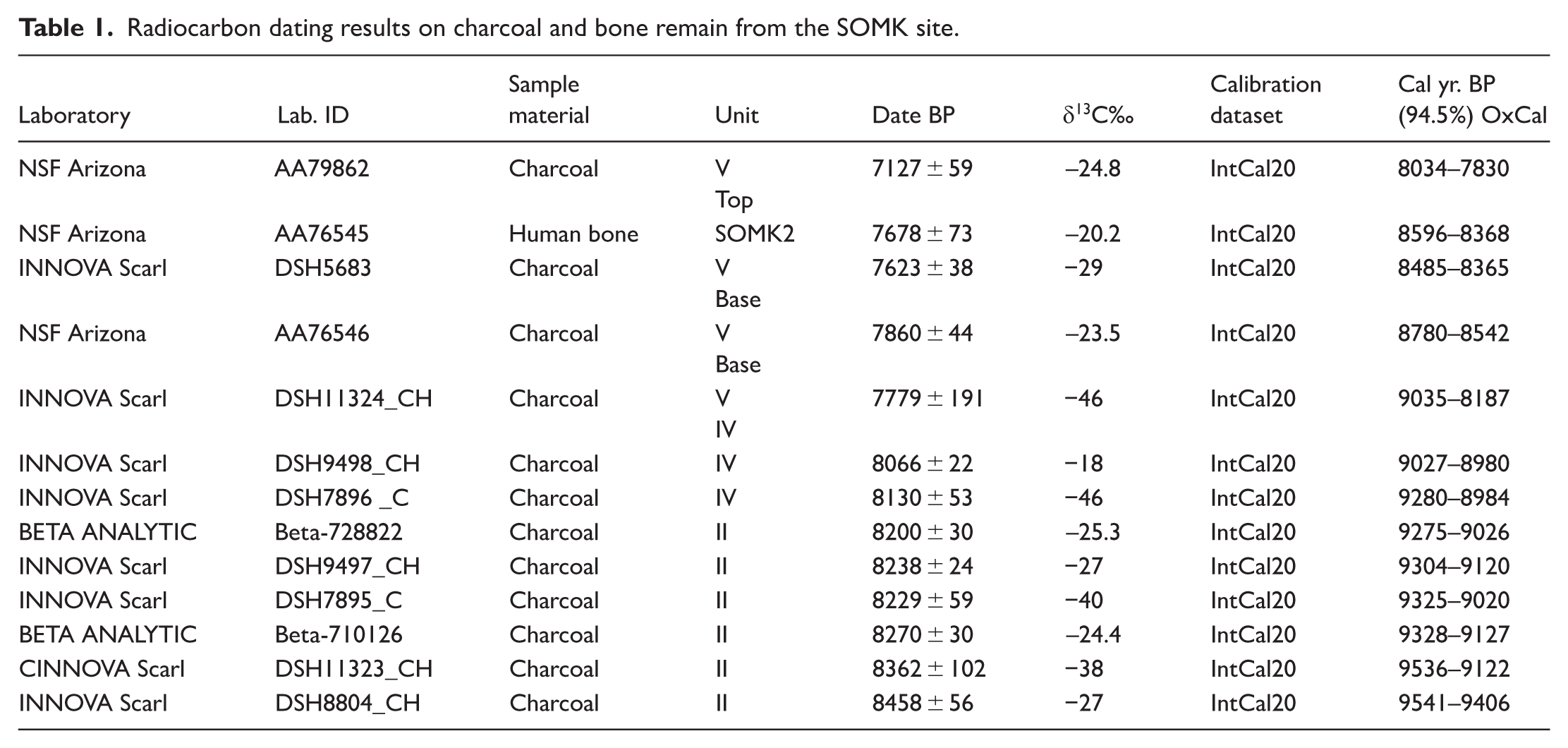
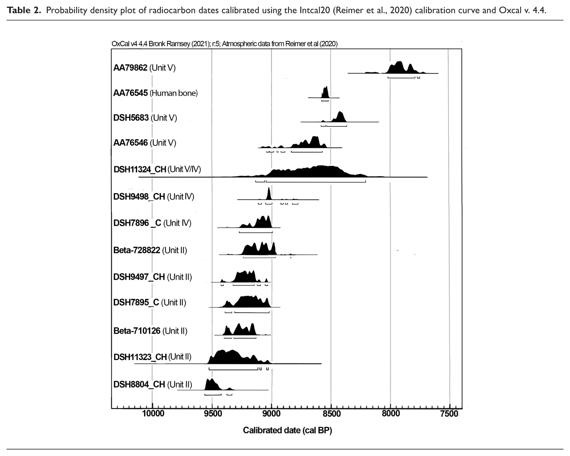
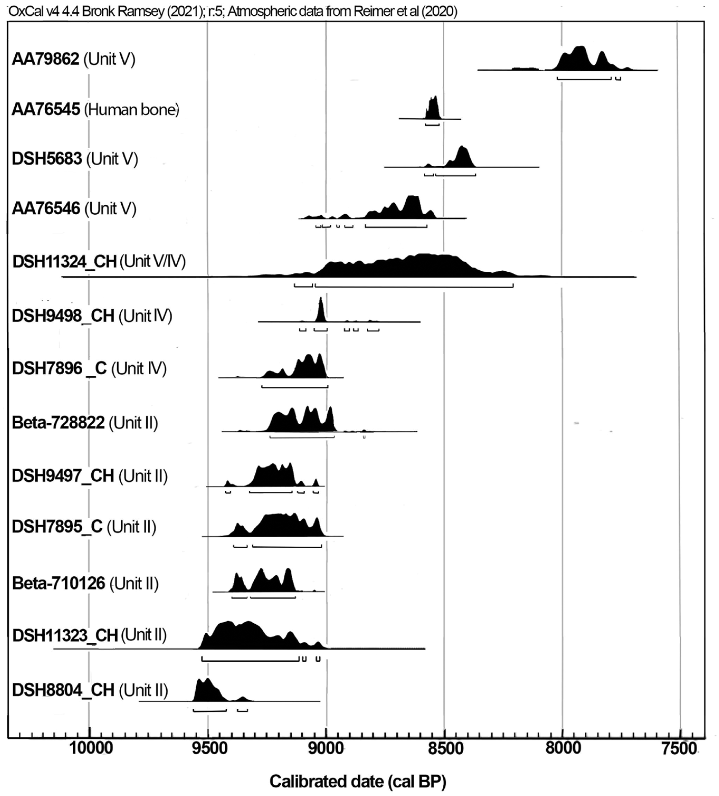
The chronology was assessed and supported by radiocarbon dating made on charcoal and bone fragments by INNOVA (Caserta), NSF -Arizona AMS Laboratory (Tucson, Arizona) and Beta Analytic (Miami, Florida). Radiocarbon dates were calibrated using the terrestrial atmospheric curve IntCal20 with the Oxcal 4.4 programme (Reimer et al., 2020). In Table 1 we provide the dates and ranges, and in Table 2 the probability ranges which are used all over the paper.
Radiocarbon dating results on charcoal and bone remain from the SOMK site.
Probability density plot of radiocarbon dates calibrated using the Intcal20 (Reimer et al., 2020) calibration curve and Oxcal v. 4.4.
Archaeological collections
The collections are under the responsibility and authority of the Soprintendenza Archeologia, Belle arti e Paesaggio per la Città metropolitana di Cagliari e le province di Oristano e Sud Sardegna. They are currently kept for research purpose at Dipartimento di Scienze Chimiche e Geologiche of Università di Cagliari.
Results
Environment, stratigraphic sequence and micromorphology
The SOMK sequence developed in a now collapsed rock shelter of the Pleistocene eolianite cliff near the mouth of the S’Omu de S’Orku stream, currently about 20 m from the modern shoreline (Figure 1(c)).
Before fieldwork started in 2007, the site was covered by rockfall deposits, recent eolian and colluvial sediments and was affected by water runoff (Figure 2(e)). Grey sediments with bone remain could be seen along the rill channels.
Systematic excavations were carried out from 2011 to 2023 over ca 18 m2, revealing a 2 m high stratigraphic sequence documenting prehistoric human presence followed by rockfalls (Figure 2(f)). On top, a recent climbing dune covered by thick vegetation does not allow to fully delineate the eolianite wall of the rock shelter and to see the eastern part of the stratigraphic sequence. However, the geomorphological analysis shows that the eolianites continue along the left side of the S’Omu de S’Orku stream (Figure 3(a) and (b); Supplemental Figure S3).
(a) Schematic geomorphological map: (1) sandy beach sediments (Holocene); (2) deposits of debris slope, eolian sediments and paleosols (Upper Pleistocene/Holocene); (3) eolianites (Upper Pleistocene); (4) littoral sandstones (marine isotope stage; (5) metamorphic basement; (6) dune; (7) rock fall deposit; (8) berm; (9) wave-cut platform; (10) alluvial fan; (11) coastal cliff; (12) gully and (b) view of the study area within its morphological context.
Cliff retreat and sheet and rill erosion affected the former rock shelter originally opening North-East towards the S’Omu de S’Orku valley (Melis et al., 2023). After the western and northern walls were demolished, the shelter was left instead looking like open westwards towards the sea. These processes removed part of the stratigraphic sequence, modifying the original morphology. Furthermore, the excavations had to be stopped to avoid the collapse of the modern dune. The unexcavated part of the site is capped by the dune sands. It will not be researched in the foreseeable future and its extension cannot be assessed.
To the south, the lower wall of the rock shelter is characterised by shelves (see Supplemental Figure S4). In the south-western sector, the one available for research, the stratigraphic sequence starts on the lowermost shelf with reddish sandy sediments (Unit I) capped by a 5–10 cm thick dark grey sandy deposit (Unit II) with small metamorphic debris (Figure 4). As mentioned above, the modern dune conceals a substantial part of the site. However, part of the wall of the rock shelter can be observed, slightly protruding at the top. In zenithal view, the trend is curvilinear. This suggests that it once opened towards the river and to the North, and that the now inaccessible innermost part of the shelter was further east (Supplemental Figure S5). Furthermore, the wide shelf that cuts the eolianites points to erosion by a water channel from the slope of the relief behind.
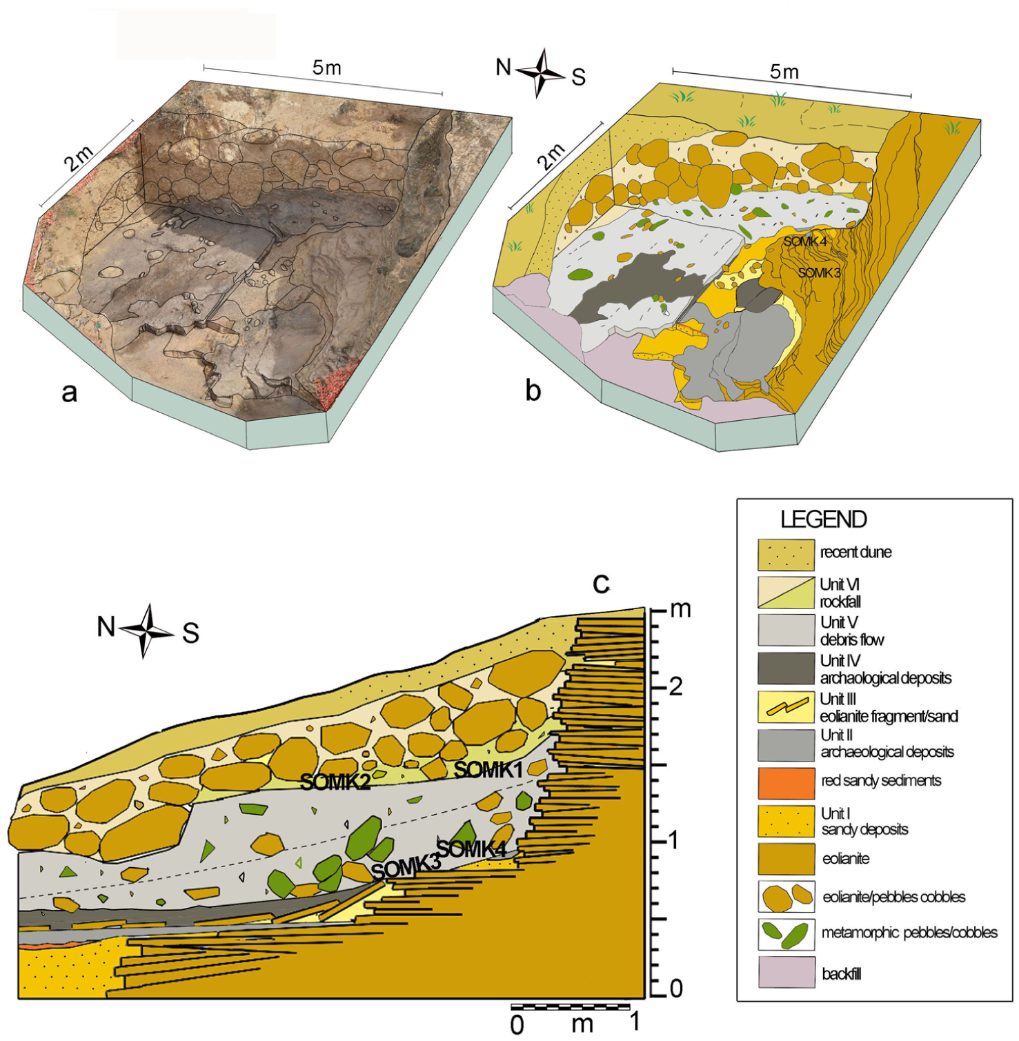
SOMK site stratigraphic sequence: (a) drone photo of the 2021 excavation showing the distribution of the stratigraphic units,(b) distribution of the different units after the 2021 excavation, and (c) schematic stratigraphic sequence of the SOMK site.
The sands of Unit I mostly originated from the weathering and washing away of the eolianites, with some eolian sand added. Interbedded eolianite fragments are found in contact with eolianites. Scattered obsidian artefacts and marine shells (Columbella rustica), pierced or not, are found on the surface of Unit I. In the southwestern sector red sandy sediments, 5 cm thick, mark the contacts between Unit I and Unit II (Figure 4; Supplemental Figure S6). Unit II is a dark grey detrital sandy deposit with dispersed metamorphic pebbles, both rounded and sharp ones. The thickness is about 10 cm in the central and southern area of the site, decreasing southward and towards the assumed interior area (Supplemental Figure S7).
Within the sands of Unit II were found obsidian and, less frequently, jasper artefacts, perforated Columbella rustica shells, small ochre aggregates, Prolagus sardus bones, often burned, and some Thyrrenicola henseli remains.
Abundant coal and ash can be seen with the naked eye. In thin section, the coarse fraction is heterometric (Supplemental Figure S8). Dominant components are rounded grains of quartz, K-feldspar and abundant lithorelicts, either weathered or fresh, of metamorphic and eolianite rocks (Figure 5(a) and (b)). The fine fraction is composed mainly of ashes. Fragments of charcoal and unidentified charred plant fragments are found embedded in a black-brown ashy groundmass. Some have sharp, irregular outer edges while others are rounded or appear degraded (Figure 5(c)). A micritic ashy groundmass was detected in some samples. There are also fragments of burned bones, some of them weathered and coated around the edges by microsparite crystals. (Figure 5(d) and (e)).
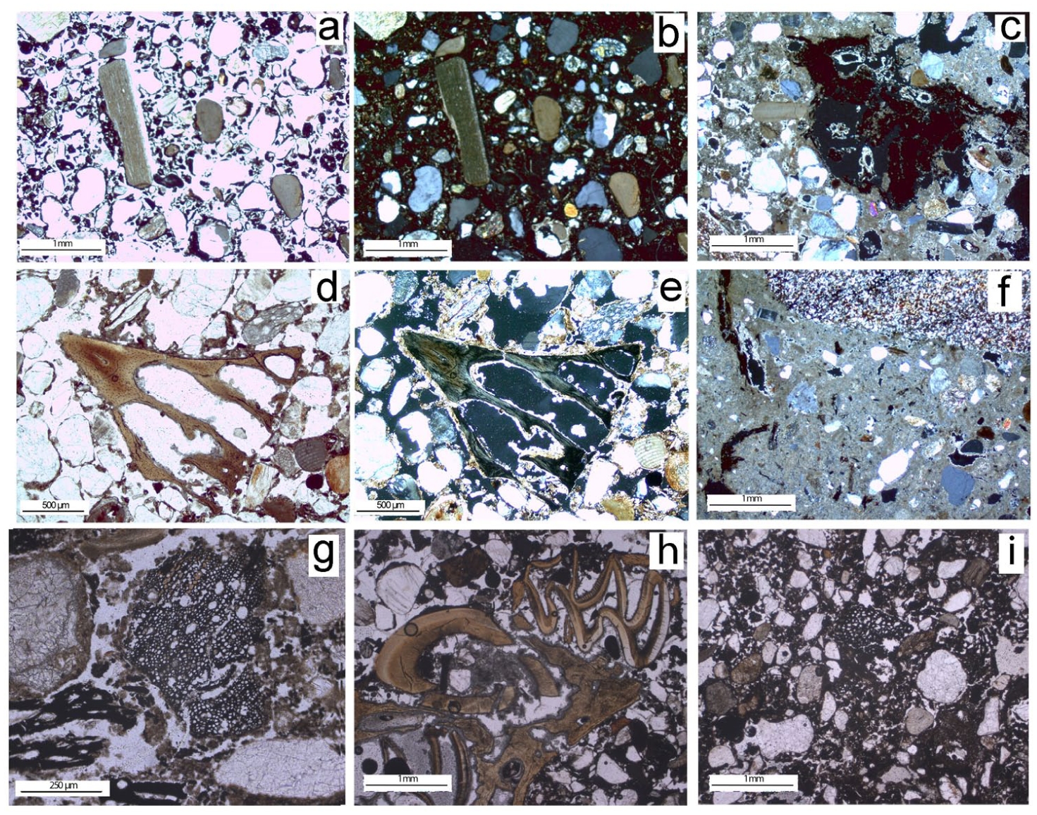
Microphotographs of the most representative microscopic components identified throughout the sedimentary sequence of the SOMK units: (a) Unit II: coarse fraction contains poorly sorted, subrounded and rounded grains quartz, K-feldspar, abundant lithorelicts of metamorphic and eolianite rocks. The fine fraction is composed mainly of ashes (PPL), (b) Unit II: same thin-section view as in (a), in XPL, (c) Unit II: irregular fragments of charcoal (XPL), (d) Unit II: burnt bone fragment of Prolagus sardus (PPL), (e) Unit II: Same thin-section view as in (d), in XPL. The bone fragment shows a coating of microsparite crystals around its edges, (f) Unit IV: micritic ashy groundmass (XPL), (g) Unit V: charcoal fragments with visible structure (PPL), (h) Unit V: burnt bone fragments of Prolagus sardus and Tyrrhenicola henseli and abundant ash (PPL), and (i) Unit II: ash and charcoal in a sandy matrix with rounded quartz grains and metamorphic and eolianite lithorelicts within the hearth (PPL).
Field and micromorphological observations suggest that the dark deposits originated from fireplaces, including hearths in the now inaccessible but more central part of the shelter. The dates of Unit II precede 9000 cal BP and are centred around 9500–9300 cal BP (Table 1, samples DSH8804_CH, DSH9497_CH, DSH7895_C, DSH11323_CH, Beta-728822).
More reddish sands (Unit III), up to 30 cm thick, cover Unit II including abundant eolianite fragments (Figure 4(c)) but no archaeological remain. Weathering and runoff water affected the site at the time of this deposit.
Above Unit III, Unit IV is a mostly grey sandy and detrital deposit including a small circular black patch with only charcoal fragments and carbonaceous lenses. More compact white ashy silty zones occur in the deposit, but no distinct layer was observed. A micritic ashy groundmass was discerned in thin section (Figure 5(f)). The ashy lenses, up to 10 cm thick, yielded charcoal fragments, Prolagus remains, small obsidian flakes and Columbella rustica shells which are further evidence of anthropic activity. The available dates for Unit IV are centred around 9200–9000 cal BP (DSH7896_CH, Beta-728822, DSH11324 CH).
Human remains, that is, SOMK4 (Figure 6(a)), are found close to a small niche (50 × 80 cm) of the eolianite wall. They are covered by about 10 cm of yellowish sand, lying partly on the eolianite shelf and partly on loose sands (Unit I). Next to SOMK4 a small round hearth dated to ca. 9500 cal BP (Tables 1 and 2, sample DSH8804_CH), provides the earliest dated evidence for Unit II and the overall human presence in the rock shelter (Figure 7).
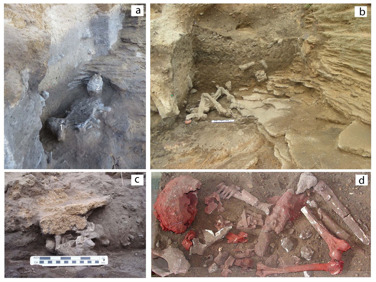
(a) Skeletal remains of SOMK4 consisting of bone fragments and sandy natural casts, located near a small niche in the eolianite wall and lying partly on the eolianite shelf and partly on loose sands (Unit I): (1) skull fragments, (2) pebbles of eolianite, (b) skeletal remains of SOMK3 covered by the debris flow deposits (Unit V; after Melis and Mussi, 2016), (c) partial skeleton of SOMK2 covered by cobbles of rockfall and lying on the debris flow deposits (Unit V; after Floris et al., 2012), and (d) heavily ochre-stained skeletal remains of SOMK1 at the top of debris flow deposits (Unit V; after Melis et al., 2012).
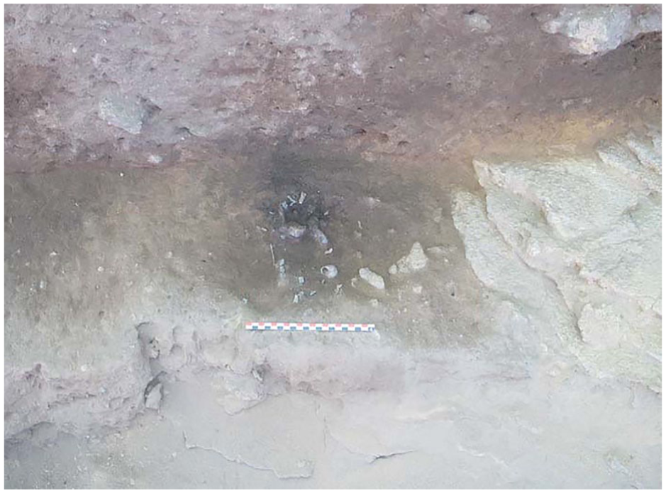
Small round hearth on the sandy Unit I with fragments of charcoal, Prolagus burned bones and a few fish vertebras.
Nearby lies SOMK3, almost at the same depth as SOMK4 (Figure 6(b), Supplemental Figure S5). It is a partial skeleton in part on an eolianite shelf and in part on about 5 cm of a dark grey carbonaceous sandy deposit (Melis and Mussi, 2016).
Debris flow sediments (Unit V) cover and partially incorporate SOMK3. Both fluvial and slope processes were active elsewhere in the site and eroded the deposit down to Unit II opening gaps in the stratigraphic sequence. Unit V (Supplemental Figure S9) is chaotic, highly unorganised, ungraded. No layering was observed even if there are thin discontinuous sand lenses. Debris of different shape and size (40–10 cm) were embedded in a grey ashy sandy silt matrix (Supplemental Figure S10). The unit is fan shaped with the apex leaning against the inner wall. The thickness decreases towards the north and west and the slope is similarly oriented northward and westward. This confirms that the sediments originated inside the rock shelter, which opened differently than today.
We interpret this deposit as a debris flow deposited during various episodes, that we subdivided in two main accumulation phases, each built during several but not distinguishable episodes suggested by the sand lenses. The dates are scarcely consistent and range from 9000 to 7800 cal BP (Tables 1 and 2, samples, DSH9498_CH, AA76546, DSH11324_CH, AA76545, DSH5683, AA79862, DSH11322_CH), fitting with a scenario of multiple episodes and of new debris flows partially reworking previous ones. However, the samples from the uppermost part of Unit V, that is, from the second phase of accumulation, are overall younger, in the range of 8400–7800 cal BP (Table 1 and Table 2). Earlier dates of ca. 8600–9000 cal BP (AA76546; DSH9498_CH) are from samples taken near the contact with Unit II and likely the outcome of mechanical mixing with that previous unit. This is most probably the case for samples DSH9498_CH and DSH11324_CH with an age statistically centred on 9035 cal BP (Table 2).
The lowest phase of Unit V includes both rounded and angular metamorphic and eolianite pebbles and boulders in a grey-brown detrital ashy sandy matrix. In the grey matrix there are few and scattered obsidian and jasper flakes, marine shell fragments, abundant bones of Prolagus sardus and Tyrrhenicola henseli (an endemic micromammal), sparse fragmented human bones and charcoal. The upper Unit V is similarly massive and chaotic with dominant metamorphic rounded and angular cobbles embedded in a very grey detrital sandy matrix rich in ash. Dispersed small obsidian and jasper artefacts were also included, with shell fragments, abundant burnt and unburnt Prolagus sardus, Tyrrhenicola henseli, Columbella rustica perforated shells and human bone fragments.
In Unit V all the thin sections show a heterometric groundmass and the same lithological composition consisting of rounded and angular metamorphic rocks and eolianite fragments (Supplemental Figure S11). We also record eolian quartz, K-feldspar mineral grains, red algae and other bioclasts, mostly originated by eolianite weathering. The biogenic components are charcoal fragments and charred plant material, some of which with visible structure, but not identifiable (Figure 5(g)). Other components are abundant ash, rare phytoliths, orange and dark coloured burnt and unburned micromammal bones fragments (Figure 5(h)).
These deposits suggest a debris flow occurring after wildfires and heavy rainfall.
Near the top of Unit V 2 skeletons (SOMK1 and SOMK2; Figure 6(c) and (d)) and dispersed human bones were discovered. SOMK1 was originally found next to the eolianite wall by amateurs (Melis et al., 2012). SOMK2, a partial skeleton close to SOMK1, was directly dated to ca. 8500 cal BP (Table 2, sample AA76545).
The dispersed human bones and artefacts suggest that archaeological assemblages from the interior of the rock shelter had been removed and re-deposited by the debris flow. This likely was also the case of SOMK2, found enveloped by the debris flow, but still in anatomic connexion, suggesting limited displacement.
A rockfall deposit of eolianite blocks (Unit VI), over 150 cm thick, seals the sequence, with a block laying directly on top of SOMK2. It is capped by the recent dune and aeolian sediments.
Archaeology
Fireplaces and other ashy deposits
Grey deposits rich in ash, charcoal and burnt bones were discovered in both Unit II, Unit IV and Unit V. They are the outcome of potentially different accumulation processes, originated either by fireplaces or by wildfires, that is, by anthropic activity or instead by natural events. Various studies (Goldberg et al., 2017; Sandgathe, 2017; Stahlschmidt et al., 2015) have shown that a combination of microscopic and macroscopic analyses is required to discriminate accumulation processes. Our micromorphological analyses actually did not reveal any differences between the two units. Rounded grains, prevailingly of quartz and feldspar, lithorelicts of metamorphic rocks and eolianites, ash, fragments of burnt and unburned bone, charcoal fragments, charred plant material, were observed in all samples. Furthermore, no clear unconformity or lithological difference characterise them. However, macroscopic indicators allow to discriminate between Unit II, Unit IV and Unit V. Observations made during fieldwork, and the evidence provided by distinct geomorphological processes, allow to sort natural deposits and deposits from anthropic activity. In Unit II, substrate rubification was observed below the grey deposits, which are delimited and devoid of pebbles, pointing to fireplaces (Supplemental Figure S12). Recent fires lightened on sand deposits close to the site similarly produced a reddish alteration, further suggesting that it was combustion at the top of Unit I which likely reddened the sands of this unit. The small round hearth (20 cm × 20 cm) next to SOMK4 and dated to ca. 9500 cal BP (DSH8804_CH) is filled by dark loose sand with charcoal, Prolagus burned and unburned bones and a few fish vertebras (Figure 7). The micromorphological analyses identified burnt bone fragments, ash and charcoal in a sandy matrix with rounded quartz grains and some metamorphic and eolianite lithorelicts (Figure 5(i), Supplemental Figure 13). No compaction was evidenced, that is, no post-depositional trampling.
In sharp contrast, Unit V is a chaotic accumulation of burnt material mixed with cobbles and pebbles, devoid of any internal stratification. This rather is a debris flow, triggered by violent rain on a likely denudated slope above the shelter and/or along the river channel, after the area had been devastated by wildfire(s) providing abundant burned material (see Discussion). Scattered human remains found in this unit and the SOMK2 skeleton at the top confirm that the debris flow affected burials in a more internal position.
We conclude that fireplaces were lit in Unit II and Unit IV, while fire (or wildfire) deposits characterise Unit V.
Lithic industry
The assemblage consists of 170 flaked implements, 71 in situ in Unit II and IV and 96 redeposited in Unit V, that will be discussed here as a whole. Obsidian is by far the most frequent raw material (88.62%; Figure 8(g)), with some jasper (10.18%; Figure 8(h)), and very little chert and quartz (one item each). The edges are fresh, the surface is not patinated, and there is little evidence of thermic shock, except for a burnt jasper core. Forty-eight flakes measuring more than 20 mm either in length or, less frequently, in width, were retrieved, some being rejuvenation flakes. Micro flakes, flake fragments and debris are 118 altogether. There are just 7 obsidian microblade lets, 8–36 mm long, and 3 residual cores, including a core fragment, 2 of them in obsidian and 1 in jasper. The few exhausted cores suggest raw material scarcity, as if provisioning was difficult. However, this contrasts with 50%–100 % of cortex on nine flakes and also on some bladelets and micro flakes. There is just a few retouched tools: six flakes are either retouched or denticulated, including a small borer, and a single end scraper. An obsidian core is also retouched into a small borer.
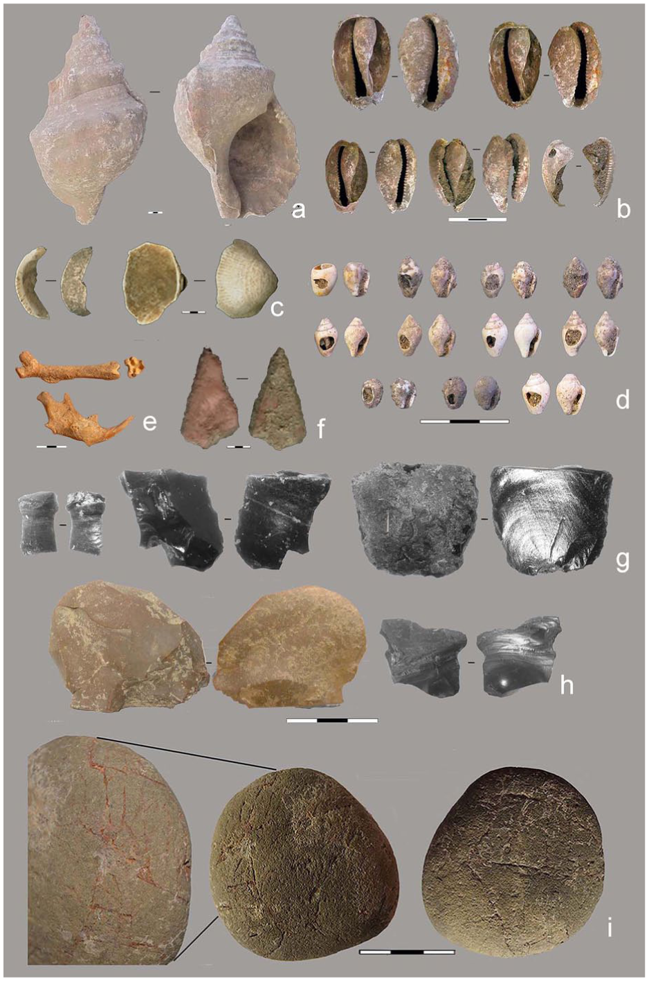
S’Omu e S’Orku materials. Remains of malacofauna: Charonia lampas specimens found within the burial of SOMK3 (a), specimens of Cyprea lurida (b), fragments and Glicymeris sp. shells (c), perforate Columbella rustica shells (d), Fauna: Prolagus sardus remains (e), Ochre crayons (f), Lithic industry on obsidian (g) and jasper (h), rounded metamorphic pebble decorated with red linear incisions (i).
Those rather expedient tools contrast with a very fine double piercer with thin ends, 5.5 cm long, on an elongated metasiltstone fragment.
A rounded metamorphic pebble decorated with red linear incisions was found in Unit IV (Figure 8(i)). Raman spectroscopy analyses attribute the red colour to ochre pigment from San Pietro Island (Mussi et al., 2024).
Fauna
Praemegaceros cazioti and Cynotherium sardous are the only fairly sized terrestrial mammals recorded in Sardinia at the end of the Pleistocene (Palombo, 2006; Valenzuela et al., 2022). Potentially they were not yet extinct in the early Holocene but remains or even bone fragments of the relevant size were not discovered at SOMK. Instead, there are very substantial amounts of bones of the much smaller Prolagus sardus (Figure 8(e)), most of them deeply burned and brown black in colour. Some, however, do not show any thermic alteration, as those from concretions surrounding the human remains or in the little hearth at the base of the deposit. There is also limited evidence of Tyrrhenicola henseli, an endemic micromammal. A few undiagnostic bird bones and fish vertebras were also retrieved.
Burials and grave goods
SOMK1, the chance discovery made in 1985, is the partially preserved and heavily ochrated skeleton of a mature male adult. It was accompanied by a large Charonia lampas, or Triton shell, with the first spiral cut, making it a trumpet-like instrument (Figure 6(d); Floris et al., 2012; Melis and Mussi, 2016).
More burials were found after proper research was started. SOMK2 (Figure 6(c)) which in 2007 was eroding from the archaeological deposit, is the partial skeleton of a young adult female. SOMK3, reached by excavations in 2011 at the base of the deposit, is another partial skeleton, an adult, probably a male. It was accompanied by another large Charonia lampas (Figure 8(a)) with a removed apex and by numerous perforated marine shells, that is, large Cypraea sp. (Figure 8(b)) and Columbella rustica specimens (Figure 8(d); Cristiani et al., 2021; Melis and Mussi, 2016).
SOMK4 (Figure 6(a)) was discovered in 2022 at the same level as SOMK3. Weathering almost completely disintegrated the bones, but the concretioned sand encasing them kept the shape of many of them, as a natural cast of a kind, even if an exceedingly fragile one. Micromorphology analysis revealed the presence of small bone fragments in the concretions. Skull fragments and the jaw with some teeth are preserved while the sandy natural cast of long bones, probable ribs and fingers was identified. The bones were extremely badly preserved.
An enlarged team is currently studying the human remains, including the sparse ones described below.
Sparse human remains
In the excavated area the debris flows (Unit V) incorporated 59 sparse human bones. Most are undiagnostic fragments, but some clearly are cranial and rib ones, both of adults and of infants. Metacarpals and metatarsals are also recorded, as well as an incisor. Some of those remains, capped by the lower debris flow, are from the lowermost deposit (Supplemental Figure S6). They could have been either redeposited elements, or locally displaced ones as from SOMK3 and SOMK4.
Ochre
Ochre, as characterised by high-resolution Raman spectroscopy, is ubiquitous (Pisu et al., 2025). It ranges from ochre lumps and tiny fragments to the deeply encrusted SOMK1 calvaria and other skeletal elements (Oxilia et al., 2025), to ochre crayons (Figure 8(f)), to a few ochre-stained cobbles and small pebbles, to flaked obsidian tools, to bivalves possibly used as small containers, to an incised and partially ochrated pebble (Figure 8(i); Mussi et al., 2024).
Marine shells
Shells were found in situ in the burials, as mentioned above (Cristiani et al., 2021; Melis and Mussi, 2016), but also redeposited in the debris flow. Notably, ca. 100 Columbella rustica specimens, perforated or not, a few bivalves as well as numerous bivalve and gastropod fragments. The fragments are manly the terminal part of the hinge and the umbonal area of Glicymeris sp. shells (Figure 8(c)).
Discussion
Most of the available stratigraphic sequence above Unit II, Unit III and Unit IV was built by debris flows which redeposited sediments from the surrounding of the rock shelter or from other parts of the cavity. In England periods with warmer/drier summers coincide with burning episodes, showing that climate is important in fire incidence during the early Holocene (Grant et al., 2014). Vannière et al. (2008) show that in Italy, at the beginning of the Holocene, that is when the SOMK shelter was settled by human groups, high climate seasonality favoured fire expansion. Drier climatic conditions and especially a dry summer season promoted ignition and biomass burning. In south-east Spain at the onset of the Holocene, fire spread exponentially in a context of higher fuel availability. Santi and Rengers (2022) furthermore, after observing the impact of modern wildfires, state that burned areas experience reduced infiltration rates, leading after the rain to overland flow. Flooding of the S’Omu de S’Orku river was also probable during seasonal rains. In May 2018, after heavy rains, we actually observed extensive and now buried ash deposits within eroded sections of the S’Omu de S’Orku riverbed (Supplemental Figure S1). These black deposits, interbedded with the coarse fluvial sediments below the modern beach sands likely originated from slope erosion after vast wildfires that local informants told us had happened in the area in 1982 and again in 1985.
At first sight, the possible role of humans cannot be ruled out in starting wildfires, voluntarily or not. Sánchez-García et al. (2024) hypothesise that, in the late Mesolithic of the south-eastern Iberian peninsula, hunter-gatherer communities purposefully transformed the landscape by burning local forests. However, this happened during a humid period (Sánchez-García et al., 2024), with a rather substantial human presence. In the case of SOMK, the paucity of evidence for local activity, and the overall archaeological scanty record of Sardinia rather suggest limited anthropic impact. Only a handful of early Holocene sites are known over an island of 24,000 km2, some still undated and outside SOMK all of them rather poor (Lugliè, 2018; Melis and Mussi, 2016).
In accordance with Marlon et al. (2013) who conclude, after a worldwide survey, that high fire activity in the early Holocene was linked to the pervasive influence of climate, we surmise that after wildfires climate change triggered slope erosion and hence the deposition of reworked sediments at SOMK.
Assuming that a Mediterranean maquis had developed at the time, the wild carob tree (Ceratonia siliqua), if part of the local vegetation, would have provided a nutritious pod and seeds, which last during a long time on the tree (Mahdad and Gaouar, 2023), while the strawberry tree (Arbutus unedo) produces fruits which ripen in autumn. Prolagus sardus was abundant and definitely consumed, together with some fish from the shore still some km away from SOMK, maybe with the adding of seafood and possibly birds. Prolagus sardus was the only recorded terrestrial mammal large enough to provide skin for clothing, containers and more, like strings.
There is firm evidence of contacts with the coastal area further south after the abundant ochre which originated 50 km away in the now San Pietro Island, an islet which at the time was still connected to the landmass of Sardinia (Melis et al., 2023; Pisu et al., 2025; Figure 1(a)). The lavishly ochrated remains of SOMK1 suggest that this pigment was abundantly available (Oxilia et al., 2025). Being found in all units, it points to consolidated and recurrent movements, possibly seasonal ones, along the coast.
Jasper, a good quality rock scarcely used at SOMK, also outcrops in San Pietro Island about 50 km from the site. The relationships with the interior are more blurred. Obsidian too is not locally available. Obsidian could be spotted in the alluvial deposits of the Campidano plain which originated from the volcanic relief of Monte Arci (Figure 1(a)) a major source of this raw material all over prehistoric times (Lugliè et al., 2006). This obsidian source was at c. 20 km from SOMK as the crow flies, but requested either crossing the Arburese relief, probably through the valleys at low elevation, or making a diversion, first northwards along the modern coast, then eastwards towards the Campidano (Figure 1(a)).
The provisioning of rocks allowing flaking activity and the production of lithic implement provide contrasting evidence of movements: obsidian corticated flakes and even corticated bladelets point to scarcely elaborated, that is, “fresh,” raw material, while the small size of the items, the small and exhausted cores, the rejuvenation flakes, the little core retouched into a short piercer, rather suggest that any available piece was exploited to a maximum and therefore that provisioning was scarce. It is also odd that jasper was in little use, as this good quality raw material was available in San Pietro Island just as the well exploited ochre.
Part of the explanation probably comes from the marginal part of the rock shelter available for research, close to a now collapsed eolianite wall which was a burial area. Everyday activities, including stone knapping, would have happened in the more central part of the cavity, opening towards the valley of the S’Omu de S’Orku river, and in front of the entrance. However even if the redeposition processes of Unit V swept part of the remains laying there, accumulating them against the former wall, the well-preserved obsidian and human bones point to limited transport. The few expedient obsidian tools contrast in turn with a single finely retouched double awl, which uniquely records the use of metamorphic rocks. Summing up, we likely do not have access to a representative sample of the lithics. Furthermore, the hominin group(s) could well have passed through SOMK more than once annually—coming from the inner region where obsidian outcrops, and later, after a circuit along the coast, returning with little remaining obsidian. This would make sense of the contrasting lithic record even if it remains unproven without access to the whole area where different activities and different seasons could be sorted out.
Conclusions
The stratigraphic sequence of SOMK, even if accessible only in a lateral part of the rock shelter, encompasses the two major climatic events of the Holocene, the 9.3and the 8.2 ka BP one, and is centred on them. Both are finely dated in ice core sequences of the Greenland ice cap and last less than two centuries each (Blockley et al., 2012, 2014). After Budsky et al. (2019) a pronounced spring/summer drought was experienced during that time-period in south-east Spain and is consistent with the evidence from elsewhere in Spain, Italy including Sicily, and from cores drilled in the Alboran Sea. Furthermore, the climate probably became more seasonally contrasted with a rainy season after dry months. Detailed evidence and quantitative data are not available from Sardinia, but we note that this climatic and environmental reconstruction fits perfectly with the record of SOMK. We interpret the evidence of wildfires followed by debris flows as proxies for environmental degradation, with erosion triggered by seasonal rains after the vegetation had been burned down. Santi and Rengers (2022) underline that overland flow is commonly observed on burned terrain. Slope instability facilitated the final collapse of the rock shelter.
Notwithstanding environmental challenges, the early Holocene hunter-gatherers who reached Sardinia were quite resilient. The SOMK record provides evidence of a remarkable adaptation to the remote island with people making use of novel resources as the cutting and brittle obsidian, not available in western continental Europe, and with little choice in animal prey outside the rather small-sized Prolagus. They started using obsidian, a raw material they had no previous experience of, as it is not available in mainland Italy or elsewhere in western Europe, where the use of flint and chert vastly prevailed. Being a glassy volcanic rock, obsidian produces very cutting but brittle flakes and blades and its proper use required the development of a new technological know-how. The human group(s) also performed complex funerary rituals, with sophisticated grave goods (Melis and Mussi, 2016), while other activities are imperfectly recorded in the area available for research.
They first came to the shelter around 9500 cal BP but with the start of the 9.0 ka event the environment changed, and wildfires repeatedly burned the landscape. From the instable surrounding slopes huge amounts of materials moved and chaotically redeposited, including earlier material from other parts of the site. We assume that humans did not settle at SOMK at that time. We do not have much direct evidence of the 1000 years of so interval between the 9.3 event and the 8.2 event, but the human presence is again positively documented by SOMK2, a skeleton directly dated at 8500 cal BP (Table 2), that is, before the start of 8.2 ka event at 8300 BP (Blockley et al., 2012). The vegetation recovered enough and eventually provided fuel for a new sequence of wildfires and related debris flow with a last charcoal sample dated 7800–8000 cal BC (Table 2). We believe that this second phase of environmental degradation is direct evidence of the 8.2 event, possibly leading to the collapse of the rock shelter.
The evidence provided by raw material provisioning shows that the Mesolithic groups cleverly exploited any available resource, as was also the case of food provisioning, with a very restricted range of available animal species. They even faced with some success repeated phases of environment degradation as highlighted in the stratigraphic sequence. However, in the end they could not overcome all obstacles. As well evidenced at SOMK, the hindrance of wildfires and landslides was compounded by a quickly rising sea level, eroding cliffs and other landmarks (Melis et al., 2023). Furthermore, acute demographic problems are suggested by the scanty archaeological record of Sardinia and Corsica. Assumedly, far away from the other human groups of the mainland, the population remained extremely sparse.
The dates assembled for sites all over Sardinia and Corsica by Lugliè (2018) point to scanty or no archaeological evidence after the 8.2 event. The Neolithic colonisation of both island and the arrival of new human groups happened several centuries later. By then, when any trace of a Mesolithic population might well have disappeared.
Supplemental Material
sj-pdf-1-hol-10.1177_09596836261432439 – Supplemental material for The Mesolithic seen through a keyhole at S’Omu e S’Orku (SOMK) and the case of environmental hazards on the western coast of Sardinia, 9500–7800 cal BP
Supplemental material, sj-pdf-1-hol-10.1177_09596836261432439 for The Mesolithic seen through a keyhole at S’Omu e S’Orku (SOMK) and the case of environmental hazards on the western coast of Sardinia, 9500–7800 cal BP by Rita T. Melis and Margherita Mussi in The Holocene
Footnotes
Acknowledgements
We are grateful to Gruppo Archeologico Neapolis (Guspini) and Comune di Arbus for the continuous support. The unflagging help and cheerfulness of Signor Giorgio Orrù, Signora Maria Novella Vacca, Michele Orrù, Rosanna Erbì, Flavio Altamura and Francesca Montis are to be acknowledged. Thanks to Giacomo Deiana e Valentino Demurtas for their support in the remote sensing analyses. The research permits were awarded through Soprintendenza Archeologia Belle arti e Paesaggio per la città metropolitana di Cagliari e per le province di Oristano e Sud Sardegna (Concessione Prot. N° 591 del 18.05.2022 del ministero Beni culturali). In 2019 the research was supported by Dipartimento di Scienze Chimiche e Geologiche, Università di Cagliari (grant FDS 2020- CAR 2019) and Parco Geominerario Storico e Ambientale della Sardegna (2019).
Author Contributions
Funding
The authors disclosed receipt of the following financial support for the research, authorship, and/or publication of this article: The authors received financial support for the research of this article by Università di Cagliari (grant FDS 2020, CAR 2019) and the Parco Geominerario Storico e Ambientale della Sardegna (2019).
Declaration of conflicting interests
The authors declared no potential conflicts of interest with respect to the research, authorship, and/or publication of this article.
Supplemental material
Supplemental material for this article is available online.
References
Supplementary Material
Please find the following supplemental material available below.
For Open Access articles published under a Creative Commons License, all supplemental material carries the same license as the article it is associated with.
For non-Open Access articles published, all supplemental material carries a non-exclusive license, and permission requests for re-use of supplemental material or any part of supplemental material shall be sent directly to the copyright owner as specified in the copyright notice associated with the article.