
Abstract
This study integrates geoarchaeological, sedimentological, chronological, and geomorphic evidence to determine the age and environmental context of the wooden-pile sites at Cao Quy and Dam Thuong, and to reconstruct Late-Holocene environmental change in the tide-dominated Bach Dang Estuary, northern Vietnam. Eight AMS radiocarbon ages cluster tightly between ~2515 and 2301 cal BP (~566–352 BCE), indicating that the piles represent late Dong Son stilt-house foundations rather than 13th-century battlefield stakes. Analysis of 29 sediment cores, combined with geodetic surveys of two paleo-sea level notches (+4.0 m and +2.3 m MSL), defines a five-stage environmental evolution from a Mid-Holocene marine embayment to the modern tidal plain. During ~2.7–2.2 ka cal BP, relative sea level estimated at ~1–2 m above present MSL and emergent paleo-highs on the Vinh Phuc surface created a short-lived window for settlement. Stratigraphic evidence shows that this stable phase ended abruptly after ~2.2 ka cal BP, when rapid inundation buried the sites beneath fine, anoxic estuarine muds. This short-lived flooding phase is interpreted to reflect enhanced tidal influence within a progressively infilling estuary, potentially associated with barrier or land-bridge development. The results provide a high-resolution framework linking stepwise sea-level history, estuarine dynamics, and human adaptation, illustrating how short-term hydro-morphodynamic variability shaped both settlement abandonment and exceptional archeological preservation along the northeastern margin of the Red River Delta.
Keywords
Introduction
The Holocene epoch was marked by profound environmental transformations across tropical and subtropical Asia, primarily driven by relative sea-level fluctuations and monsoon variability. In coastal Northern Vietnam, these processes governed the formation and evolution of the Red River Delta and its associated estuarine systems (Figure 1), as evidenced by a series of sediment-core and geomorphic studies. On the delta plain itself, sediment cores indicate a regional sea-level highstand of ~+2 to +3 m above the national Mean Sea Level (MSL; Hon Dau Datum, equivalent to +1.41 m EGM96) between ~6−4 ka cal BP (Funabiki et al., 2012; Tanabe et al., 2006). In contrast, higher sea-level markers are preserved in the adjacent karstic landscapes. In Ha Long Bay, evidence points to a highstand of ~+3.5 m relative to MSL (Boyd and Lam, 2004; corrected by Tanabe et al., 2006), while in Trang An, distinct notches indicate multiple stable sea levels reaching up to +5.6 m relative to MSL (Kahlert et al., 2021). Regional syntheses across Southeast Asia indicate a broadly consistent Mid-Holocene highstand of +2−4 m, although site-specific deviations reflect differential subsidence, compaction, and local hydrodynamic regimes (Mann et al., 2019). After ~4 ka, relative sea level gradually fell toward the modern datum. During this period, increased fluvial sediment supply, largely attributed to anthropogenic deforestation in the upper catchment, enhanced deltaic progradation (Funabiki et al., 2012; Tanabe et al., 2006). However, a climatic trend of increasing humidity between ~3.2 and 2.2 ka cal BP, peaking around 2.8 ka cal BP following the peak arid phase (Griffiths et al., 2020), suggests that climate may also have played a contributing role in the sediment budget of the Red River Delta.
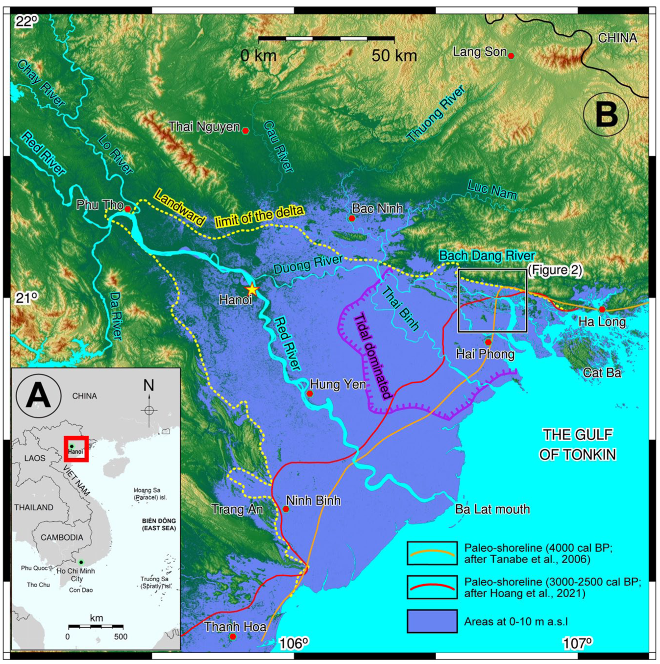
(a) Location of the study area within Vietnam and Southeast Asia. The red rectangle indicates the extent of panel (b). (b) The Red River Delta and its main river systems in northern Vietnam. The DEM was generated from USGS SRTM 1 arc-second data (30 m resolution). The landward limit of the delta follows Tanabe et al. (2006). The study area is located along the Bach Dang Estuary, a funnel-shaped estuary where sediment accumulation has been largely influenced by tidal dominance during the Mid-Late-Holocene. Paleo-shoreline positions in the Late-Holocene are after Tanabe et al. (2006) and Yen et al. (2021), and were redrawn following Rabett et al. (2023).
Within this regional framework, the Red River Delta exhibits a clear hydrodynamic zonation (Hori et al., 2004; Tanabe et al., 2003, 2006). The central delta plain around Hanoi is fluvial-dominated, the Nam Dinh-Thai Binh coast is wave-dominated, and the northeastern margin-including the Bach Dang Estuary-is tide-dominated and shielded from wave energy by Hainan Island. This zonation has strongly controlled the spatial patterns of sediment accumulation and shoreline evolution throughout the Late-Holocene. Paleo-shoreline records indicate that shoreline evolution after the Mid-Holocene highstand was spatially variable across the delta. While the wave-dominated southern delta plain experienced significant seaward progradation, shoreline migration in the tide-dominated northeastern margin, including the Bach Dang Estuary, was more limited, characterized primarily by the gradual infilling of estuaries and the development of tidal flats (Funabiki et al., 2012; Tanabe et al., 2006). Such contrasting hydrodynamic settings have exerted a strong control on the spatial patterns of sediment accumulation, estuarine infilling, and human settlement throughout the Late-Holocene.
Archeologically, the Bach Dang region is closely associated with the Dong Son culture (~800−100 BCE), one of Southeast Asia’s most advanced prehistoric societies (Bellwood, 2007; Higham, 1996; Tan, 1994). Dong Son communities mastered bronze casting and developed waterborne livelihoods centered on stilt-house architecture and riverine transport. The Viet Khe site in Thuy Nguyen District (Hai Phong), located ~10 km southeast of the Cao Quy archeological site (Figure 2), dated to the fifth century BCE, represents one of the most elaborate boat-shaped burials of the Dong Son culture (Bellwood et al., 2007; Tan, 1994). It yielded an exceptional assemblage of bronze drums, axes, bells, and ritual vessels, illustrating advanced metallurgical craftsmanship and the deep symbolic connection between aquatic environments and ritual practice (Liem, 2024). Its proximity to the Bach Dang Estuary implies long-standing human adaptation to tide-dominated coastal settings.
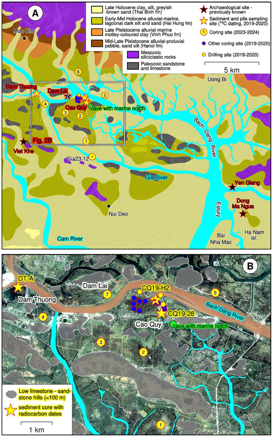
(a) Spatial distribution of geological formations, the drainage network, and sampling locations for sediment cores and wooden piles in the Cao Quy–Dam Thuong area and surroundings. Geological formations after the 1:200,000 geological map (Hai Phong sheet F48−XXIX; Vietnam Department of Geology and Minerals, 2000). (b) GoogleTM satellite imagery (2002) showing belts of limestone hills and low-relief, weathered sandstone hills (<+100 m relative to MSL), together with the local drainage network in the Cao Quy–Dam Thuong area. Sampling locations as in panel (a), shown at higher detail.
The Bach Dang Estuary is historically renowned as the site of naval victories of the Tran Dynasty in CE 1285 and 1288, when General Tran Hung Dao used submerged wooden stakes to defeat Mongol fleets. Excavations at Yên Giang and Dong Ma Ngua (Quang Yen, Quang Ninh) have revealed hundreds of aligned wooden stakes dated to CE 1270–1400 (Kimura et al., 2014), in close agreement with historical records. In contrast, another group of wooden piles, structurally distinct from the battlefield stakes-was unearthed in 2019–2020 at Cao Quy and Dam Thuong (Thuy Nguyen, Hai Phong). Owing to their proximity to the Bach Dang River, these piles were quickly and widely assumed to be relics of the same 13th-century battles, despite the absence of supporting chronological or contextual evidence. This assumption, frequently repeated in local exhibitions, tourism narratives, and educational media, has contributed to a persistent yet unverified historical interpretation of the sites.
In contrast, preliminary stratigraphic observations suggest that the wooden piles at Cao Quy and Dam Thuong differ structurally and contextually from the known battlefield stakes, and may represent architectural foundation posts of stilt dwellings rather than war defenses. If so, understanding their preservation requires explaining how such habitation structures-normally built in subaerial settings-became rapidly buried and remained intact beneath estuarine muds. Addressing this question necessitates a geoarchaeological approach that links human occupation with Late-Holocene environmental dynamics.
Despite its geological and historical significance, the Holocene paleoenvironmental evolution of the Bach Dang Estuary remains poorly constrained compared with the central Red River Delta (Tanabe et al., 2006; Yen et al., 2021) and the Ha Long-Trang An karst coast (Boyd and Lam, 2004; Kahlert et al., 2021; Rabett et al., 2023). This study integrates sedimentological, chronological, and geoarchaeological evidence to reconstruct Late-Holocene environmental change in the Cao Quy-Dam Thuong area. By combining sediment-core stratigraphy, radiocarbon dating of wooden piles, and geomorphic elevation data, we aim to (1) constrain the timing and processes of estuarine infilling during Late-Holocene regression, (2) assess the environmental context of wooden-pile preservation, and (3) elucidate the relationship between Holocene sea-level change, tidal amplification, and human settlement in this dynamic coastal landscape.
More broadly, this study addresses a fundamental question in geoarchaeology and coastal science: how human settlements respond to rapidly changing coastal environments. Across tropical and monsoon-influenced regions, Late-Holocene shoreline shifts, estuarine infilling, and relative sea-level variability have been recognized as key drivers of settlement dynamics, yet well-constrained case studies linking high-resolution sedimentary records with archeological evidence remain limited in Southeast Asia.
In this context, the Bach Dang estuary provides a valuable natural laboratory for examining how coastal populations adapted to tide-dominated environments during the transition from the Bronze Age to the Early Iron Age. The exceptional preservation of wooden structures at Cao Quy offers a rare opportunity to investigate how rapid sedimentation processes can simultaneously drive settlement abandonment and archeological preservation. As such, the findings of this study have broader implications for understanding human–environment interactions in coastal and deltaic systems worldwide, particularly in regions subject to strong monsoonal forcing and dynamic shoreline evolution.
Regional setting
The Bach Dang Estuary lies on the northeastern margin of the Red River Delta, Northern Vietnam, marking the boundary between Hai Phong City and Quang Ninh Province (Figure 1). It connects the Kinh Thay-Da Bac river system to the Gulf of Tonkin through a funnel-shaped tidal mouth. The estuary is enclosed by low-relief limestone hills in the Kinh Mon-Thuy Nguyen area (Hai Phong) and by siliciclastic hills of the Dong Trieu-Uong Bi range (i.e. Yen Tu range, Quang Ninh). During earlier highstand periods, these surrounding hills sheltered the estuary from direct marine wave action, constraining its sedimentation and geomorphic evolution.
The modern hydrological regime is strongly tide-dominated. Tide-gauge records at Hon Dau, ~14 km from the mouth, indicate spring-neap tidal ranges of ~2.6−3.6 m and ~0.5−1.0 m, respectively, with regional maxima up to ~4.2 m during spring tides (Vinh et al., 2018). These strong tidal currents generate bidirectional currents that govern sediment transport, shaping extensive tidal flats, mangrove marshes, and a dense network of tidal channels around Bai Nha Mac (Dam Nha Mac), Ha Nam, and Cat Hai islands. This regime is modulated by a subtropical monsoonal climate, with mean annual precipitation of ~1500−1800 mm concentrated between May and October (Anh, 2023). Salinity intrusion is substantial, extending 30−50 km inland during the dry season before retreating seaward during the wet season (Funabiki et al., 2012).
Sedimentation in the Bach Dang is primarily influenced by tidal reworking and local sources rather than by sustained deltaic input. Unlike the central and southern sectors of the Red River delta, the Bach Dang system receives limited fluvial sediment from the upstream Kinh Thay-Da Bac network, and strong tidal energy likely limits sediment conveyance from the Red River main stem (Tanabe et al., 2006). Local input is supplied by rivers such as the short but steep Cam River (Sông Cầm), which drains the Dong Trieu-Uong Bi hills. As a result, surface sediments consist predominantly of fine-grained silty mud (mean ≈ 87 vol. %) with 2–7 wt. % organic matter, indicating steady accretion in a low-energy, tide-dominated depositional setting (Anh, 2023).
The late Quaternary stratigraphy of the Bach Dang sector is broadly comparable to that of the wider Red River Delta (Tanabe et al., 2003, 2006; Yen et al., 2021) and includes (Figure 2): (1) a basal reddish to yellowish mottled hard clay of the Vinh Phuc Formation (Late Pleistocene–Early Holocene), interpreted as an oxidized paleosol; (2) a gray to dark-gray estuarine-marine mud unit of the Hai Hung Formation (Middle-Late-Holocene), deposited during the Mid-Holocene transgression; and (3) an upper silty clay sequence of the Thai Binh Formation (Late-Holocene-recent), representing tidal-flat and marsh accumulation during the Late-Holocene regression. A mottled hard clay surface at the contact between the Vinh Phuc and Hai Hung formations serves as a key regional marker for the onset of Holocene marine transgression. Although chronological data for the Late-Holocene deposits in the Bach Dang area remain limited, their superposition above the Vinh Phuc Formation suggests they are younger than ~4 ka BP (Duong et al., 2020).
Materials and methods
Following the discovery of two wooden-pile sites at Cao Quy (December 2019) and Dam Thuong (February 2020) in Thuy Nguyen, Hai Phong, systematic excavations by the Institute of Archaeology (Vietnam Academy of Social Sciences) revealed well-preserved wooden piles embedded in gray mud at depths of 1−2 m below the surface. Subsequent interdisciplinary investigations were initiated to clarify their age, origin, and paleoenvironmental context. Our research team carried out direct sampling of wooden piles for radiocarbon dating and collected sediment cores in and around both sites between late 2019 and early 2020 to document subsurface stratigraphy and sedimentary facies. During the same campaign, additional mechanical drilling was performed along adjacent riverbanks to investigate lateral facies variation. Geodetic surveys were also conducted to establish elevation control for the sampling sites and to measure marine notches preserved on nearby limestone cliffs. In 2023–2024, supplementary sediment cores were retrieved from areas farther away from the archeological sites to provide a broader understanding of the regional depositional framework.
Sediment coring
Sediment sampling was conducted using a combination of peat coring and rotary drilling between late 2019 and early 2020 in the Cao Quy and Dam Thuong areas of Hai Phong City (Figure 2; Table 1). A total of 26 half-cores and 3 whole cores were recovered from archeological excavation pits, rice fields, and low-terrace settings adjacent to the Bach Dang River. Most half-cores were obtained using a Russian-type peat corer with a 60 mm barrel diameter, reaching maximum depths of 4–5 m and targeting fine-grained Holocene sediments overlying the oxidized reddish-yellow clay of the Vinh Phuc Formation (blue circles in Figure 2). Coring operations were typically terminated when the yellowish mottled hard clay layer was encountered, marking the top of the Pleistocene substratum. Additional mechanical drilling (e.g. CQ19-05, CQ19-12, CQ19-13; yellow circles in Figure 2b; Table 1) was carried out along the Bach Dang River to document lateral facies changes in near-channel environments. The boreholes were drilled from the ground surface downward, as sediments at these locations were relatively compact and unsuitable for manual coring. Elevation data for all sampling sites were measured using a total station and verified against 1:25,000 topographic maps to ensure consistent vertical control. In 2023–2024, supplementary cores (TN24−1 to TN24−7, yellow numbered circles 1−7 in Figure 2) were collected from areas farther north of the Cao Quy and Dam Thuong. In addition, a piston core was obtained along the Gia River (~10 km southwest of Cao Quy; core GIA23−12, Figure 2a), to broaden the stratigraphic context. These sites are located in the inner estuarine sector of the Bach Dang system, ~15−20 km inland from the present tidal mouth, a zone sensitive to changes in both fluvial discharge and tidal intrusion.
Location, elevation, and core information of the sediment sampling sites shown in Figure 2.
The drilling/coring operations were typically discontinued once the yellowish mottled hard clay layer was encountered. Elevation data were measured using a total station. Three sediment cores were selected for radiocarbon dating.
A.: not available (depth to hard clay could not be determined).
Sediment core with 14C dates.
Elevation estimated from a topographic map (scale 1:25.000) or echo-sounding.
Three representative sediment cores − CQ19-H2, CQ19-28, and DT-A − were selected for AMS 14C dating to establish chronological control of the sedimentary sequence (Tables 1 and 3; yellow stars in Figure 2). Cores CQ19-H2 (Figure 3c) and DT-A were obtained directly from the archeological excavation areas of the Cao Quy (Figure 3) and Dam Thuong wooden-pile sites, respectively, enabling stratigraphic correlation between the dated sediment horizons and the cultural layers containing the wooden piles. Core CQ19-28, in contrast, was collected ~300 m south of pit H2, in the Cao Quy village rice field adjacent to a small tidal creek (Figure 2b), to document the surrounding depositional facies and their relation to the archeological context.
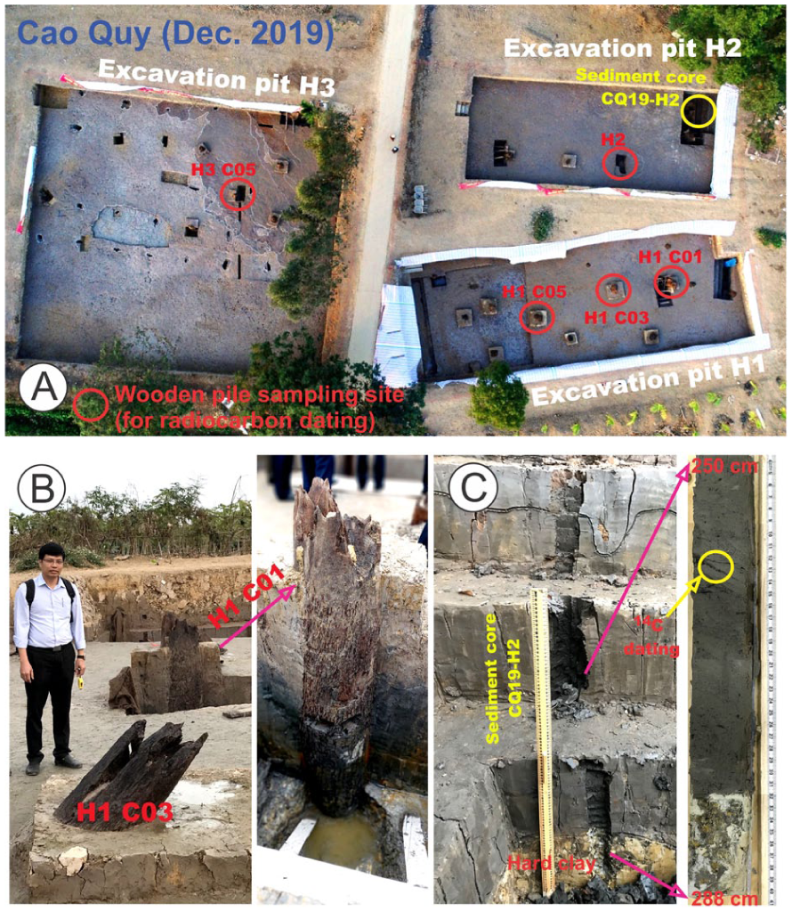
(a) Drone photograph of the Cao Quy archeological excavation area with three excavation pits. Five wooden piles were sampled for 14C dating and one sediment core was collected for this study. (b) Close-up view of two wooden piles sampled for 14C dating in pit H2. (c) Location of the sediment core at the northeastern corner of pit H2, and a 250–288 cm section of the recovered core showing inclined bedding in the upper part and a stiff clay layer at the base, within which one leaf fragment was sampled for 14C dating. Annotated drone image adapted from ZNEWS.VN (2019). The location of these figures is indicated by a yellow star (CQ−19−H2) in Figure 2b.
Wooden-pile sampling
Eight wooden piles were sampled for radiocarbon dating from two archeological localities (yellow stars in Figure 2; Table 2): five from Cao Quy (excavation pits H1 to H3; Figure 3a) and three from Dam Thuong (DT4−DT6). These piles consisted of cylindrical hardwood posts, 10−25 cm in diameter and 1.5−2.5 m in preserved length, vertically embedded within compact clay layers. At Cao Quy, most piles were set into yellowish mottled hard clay, whereas at Dam Thuong they were driven into gray silty clay at depths of about 1−2 m. The pile bases were flat rather than pointed. In several cases, the upper portions appeared slightly tapered or pointed due to weathering, and some exhibited chisel marks. Well-preserved piles were sampled from their lower or mid-sections, where wood texture and fiber alignment remained intact. The weathered outer rim (~5 mm thick) was carefully removed using stainless-steel knives, and fine wood fibers were extracted from the outermost growth rings with sterilized scalpels. This procedure minimized contamination and ensured reliable 14C measurements to reflect the timing of tree felling and pile emplacement, rather than older heartwood that could predate construction by decades or centuries. All wood fragments were placed in pre-cleaned centrifuge tubes, labeled, sealed in polyethylene bags, and stored at −18 °C until pretreatment and 14C analysis.
Radiocarbon results for eight wooden piles from excavation pits at the Cao Quy and Dam Thuong archeological sites.
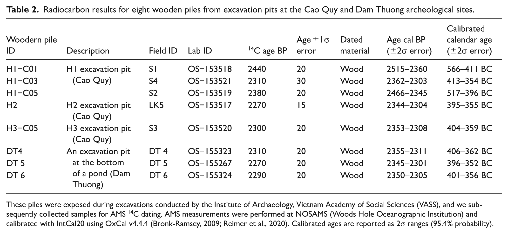
These piles were exposed during excavations conducted by the Institute of Archaeology, Vietnam Academy of Social Sciences (VASS), and we subsequently collected samples for AMS 14C dating. AMS measurements were performed at NOSAMS (Woods Hole Oceanographic Institution) and calibrated with IntCal20 using OxCal v4.4.4 (Bronk-Ramsey, 2009; Reimer et al., 2020). Calibrated ages are reported as 2σ ranges (95.4% probability).
Radiocarbon dating and age calibration
Radiocarbon dating was performed on eight wooden-pile samples (Table 2) and nine sediment samples (Table 3) to establish a chronological framework for the Late-Holocene deposits at the Cao Quy and Dam Thuong sites. The sampling and pretreatment protocols followed the procedures described in Ojala et al. (2023). All samples were pretreated using the standard acid-base-acid (ABA) method to remove carbonates and humic contaminants, combined with a hydrofluoric acid (HF) treatment to dissolve clay minerals and remove adsorbed humic acids. The cleaned and dried samples were then shipped to the NOSAMS laboratory (Woods Hole Oceanographic Institution, USA), where they were combusted to CO2, converted to graphite, and analyzed by Accelerator Mass Spectrometry (AMS) for 14C analysis. Radiocarbon ages were calibrated against the IntCal20 calibration curve (Reimer et al., 2020) using OxCal v4.4.4 (Bronk-Ramsey, 2009). All calibrated ages are expressed as cal yr BP (2σ, 95.4% probability), with corresponding cal BCE/CE ages provided for archeological interpretation. To construct a continuous chronological model for sediment accumulation, age-depth modeling was conducted using the rbacon Bayesian package (Blaauw and Christen, 2011). Among the three dated sediment cores, CQ19-28 was selected for age-depth modeling owing to its stratigraphic integrity and continuous sedimentation.
Radiocarbon samples from three sediment cores collected at the Cao Quy and Dam Thuong sites.
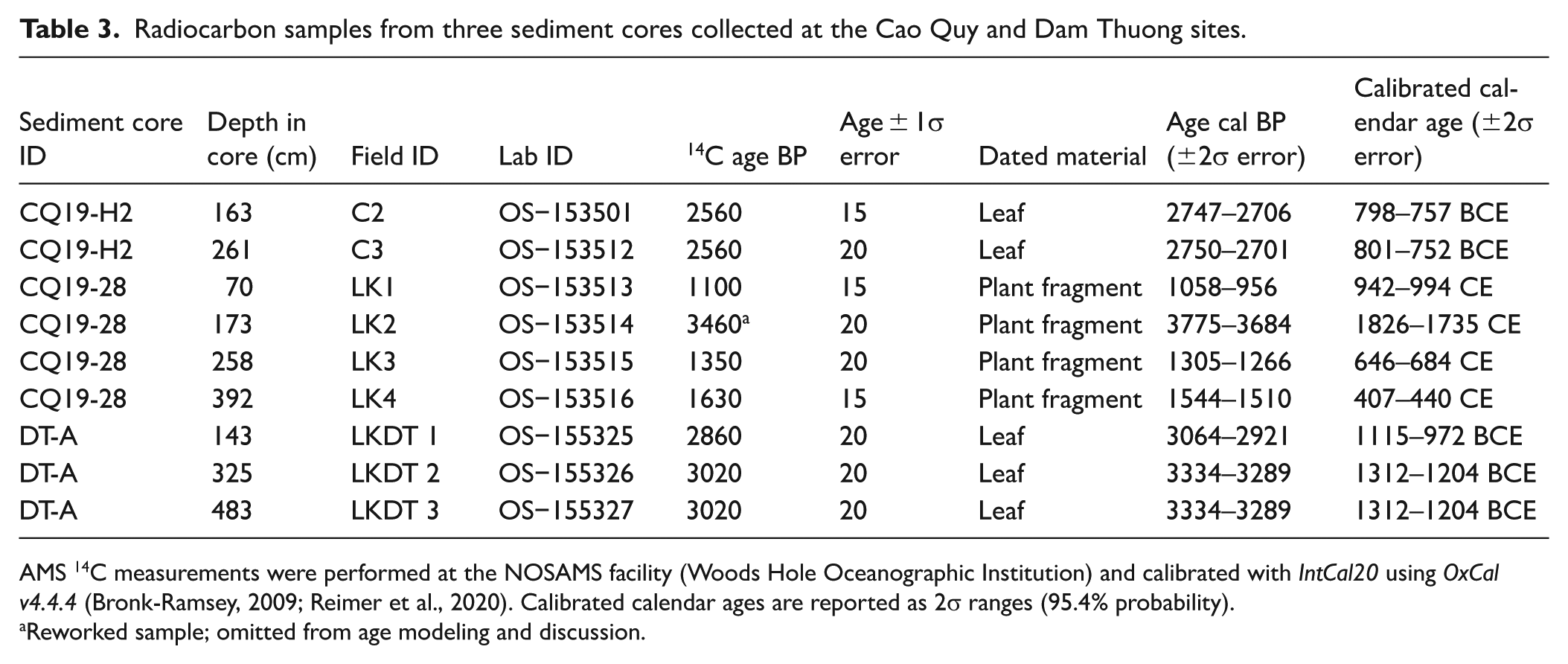
AMS 14C measurements were performed at the NOSAMS facility (Woods Hole Oceanographic Institution) and calibrated with IntCal20 using OxCal v4.4.4 (Bronk-Ramsey, 2009; Reimer et al., 2020). Calibrated calendar ages are reported as 2σ ranges (95.4% probability).
Reworked sample; omitted from age modeling and discussion.
Laboratory analyses
Sediment cores were processed and analyzed at the sedimentology and geochemistry laboratories following standard protocols for Holocene estuarine sequences. The core surfaces were first cleaned, photographed under polarized light, and visually logged for color, texture, and sedimentary structures following Nguyễn-Văn et al. (2023). Magnetic susceptibility was measured at 1 cm intervals using a Bartington® system with a surface scanning sensor (MS2E) to characterize lithological variations and identify stratigraphic boundaries. Subsamples for radiocarbon dating were collected as described in Sections 3.1 and 3.2. Additional subsamples were analyzed for organic-matter using the loss-on-ignition (LOI) method, with sequential heating at 550°C (4 h) to determine organic matter content (OM). Grain-size analyses were conducted on the <2 mm fraction following standard pre-treatments: repeated oxidation of organic matter with H2O2 (30%), removal of carbonates using 10% HCl, elimination of biogenic silica by NaOH treatment, and dispersion with sodium hexametaphosphate (Na6P6O18) to prevent flocculation. The treated suspensions were centrifuged, diluted, and analyzed using a HORIBA® LA-950 laser diffraction particle-size analyzer.
Geodetic survey and elevation control
Geodetic measurements using a Leica total station were used to establish elevation control for all sediment cores, ground surfaces, and excavation pits (Table 1). Core-top elevations were tied to local geodetic benchmarks and cross-checked against 1:25,000 topographic maps to ensure consistency within a vertical precision of ±10 cm. To further verify vertical accuracy, additional leveling was performed against a staff gauge installed at a sluice gate along the Bach Dang River, located near the Cao Quy site. Additional surveys were carried out along the limestone cliffs and cave systems surrounding the Cao Quy area to document geomorphic features associated with paleo-sea level stands. Two distinct marine notches were observed on the limestone cliffs near Cao Quy, and their elevations were measured relative to the Vietnamese national vertical datum (MSL; Figure 4). These geomorphic markers are used as reference points for interpreting relative sea-level positions and stratigraphic relationships across the Bach Dang estuary.

Paleo–sea-level notches on a limestone cliff near a cave in the Cao Quy area. A shallow upper notch occurs at ~+4.0 m relative to MSL, whereas a lower, sharply incised notch (indicated by the yellow square-dotted line) lies at +2.3 m relative to MSL. See discussion in Section 5 regarding the inferred ages and sea-level significance of these features. The man holding the tape measure is ~170 cm tall. Photo location shown in Figure 2.
Results
Radiocarbon dating results of archeological wooden piles
Eight AMS 14C ages were obtained from wooden piles collected at the Cao Quy and Dam Thuong archeological sites (Table 2; Figure 3). The Cao Quy series (samples H1−C01, H1−C03, H1−C05, H2, and H3−C05) yielded conventional radiocarbon ages ranging from 2440 ± 20 BP to 2270 ± 15 BP, corresponding to calibrated calendar ages between ~566 and 355 BCE (2σ, 95.4% probability). The three Dam Thuong samples (DT4−DT6) produced comparable results, with ages between 2310 ± 20 BP and 2290 ± 20 BP, equivalent to ~406−352 BCE. All eight samples yield calibrated ages that cluster within a narrow range between ~2515 and 2301 cal BP (≈ 566–352 BCE). . Most radiocarbon ages obtained from the wooden piles (~2440−2270 BP) fall within a broad calibration plateau of the IntCal20 curve (~2750−2350 cal BP; Reimer et al., 2020), which limits chronological resolution to ~300−400 years. The calibrated ages cluster within this interval, corresponding to the fifth−fourth centuries BCE.
Lithology and grain-size of sediment cores
A total of 29 sediment cores (26 half-cores and 3 full drilled cores) were recovered from the Cao Quy and Dam Thuong areas (Figure 2a). Three representative cores—CQ19-H2, CQ19-28, and DT-A—were selected for detailed lithological, grain-size, and chronological analyses because they were taken from or near the archeological exposures containing wooden piles and preserve relatively continuous Late-Holocene sediment sequences (Figures 2b and 3). The remaining cores were primarily used to determine the depth of the underlying mottled hard-clay surface (Vinh Phuc Formation) and to trace the lateral variation of Holocene deposits across the estuarine plain.
Core CQ19-H2, taken adjacent to pit H2 at Cao Quy, consists mainly of dark gray to greenish-gray silt with faint lamination. The fine-sand fraction averages ~12%, magnetic susceptibility ranges 10−30 × 10−5 SI, and OM content 5−9 wt. %, peaking near 1.4 m depth. Core CQ19-28, ~300 m south of pit H2, is dominated by light- to dark-gray silt with less sand (~6%) and higher magnetic susceptibility (40−50 × 10−5 SI). Organic matter varies from 6% to 10%, with minor reddish silt layers between 3.4−2.4 m depth. The uppermost section contains rootlets and plant fragments. Core DT-A from Dam Thuong comprises dark-gray to light-gray silt with weak lamination and scattered plant remains. The fine-sand fraction averages ~8%, magnetic susceptibility ~30 × 10−5 SI, and OM increases upward from 6% to 10 % (Figure 5).
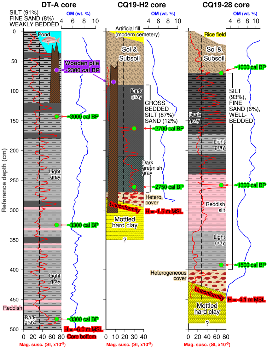
Lithological characteristics and radiocarbon chronology of sediments from the Cao Quy and Dam Thuong cores. The relative distribution and radiocarbon ages of wooden piles from excavation pits adjacent to the core sites are also shown. At Cao Quy, two sedimentary sequences dated to ~2700 years BP and 1500–1000 years BP overlie a mottled hard clay weathering surface. The heterogeneous cover layer comprises plastic clay, brick-red pebbles, limestone fragments, sand, and carbonate bioclasts (shells). Dark gray sediments are typically rich in plant remains, whereas reddish silty clay deposits are interpreted as flood deposits derived from the Red River–Bach Dang system.
Overall, the three representative cores are dominated by gray silt with variable organic content and minor sand admixture. Variations in grain size, OM, and magnetic susceptibility are observed between the cores and between the two localities.
Radiocarbon chronology of sediment cores
Nine AMS 14C ages obtained from three representative sediment cores—CQ19-H2, CQ19-28, and DT-A—are used to constrain the chronology for the Holocene sequence at the Cao Quy and Dam Thuong sites (Table 3; Figure 5).
At Dam Thuong, three samples of leaf fragments from the DT-A core yielded calibrated ages ranging from ~3.3 ka cal BP to 3.0 ka cal BP (≈ 1300–970 BCE). The basal and middle horizons (483−323 cm depth) overlap within the 3330–3290 cal BP interval. The uppermost dated horizon (143 cm depth; 3020 cal BP) marks the youngest dated level in the core. The 5-m-long sequence did not reach the underlying mottled hard-clay surface.
At Cao Quy, two leaf samples from CQ19-H2 (261 cm and 163 cm depth) yielded very similar calibrated ages of 2750–2700 cal BP (≈ 800–750 BCE). Both horizons occur immediately above the mottled hard-clay surface of the Vinh Phuc Formation (Figure 5). The base of CQ19-H2 lies at about −1.3 m MSL, roughly 5 m higher than the base of the Dam Thuong sequence (~-6 m MSL).
The CQ19-28 core, cored ~300 m south of pit H2, contains four AMS 14C ages (excluding one reworked sample) between ~1.6 ka cal BP and 1.0 ka cal BP (≈ 350–950 CE). The Bayesian age-depth model indicates modeled sediment accumulation rates of ~4−6 mm yr−1 (Figure 6). The upper 0.5 m of the core shows pedogenic alteration and minor truncation.
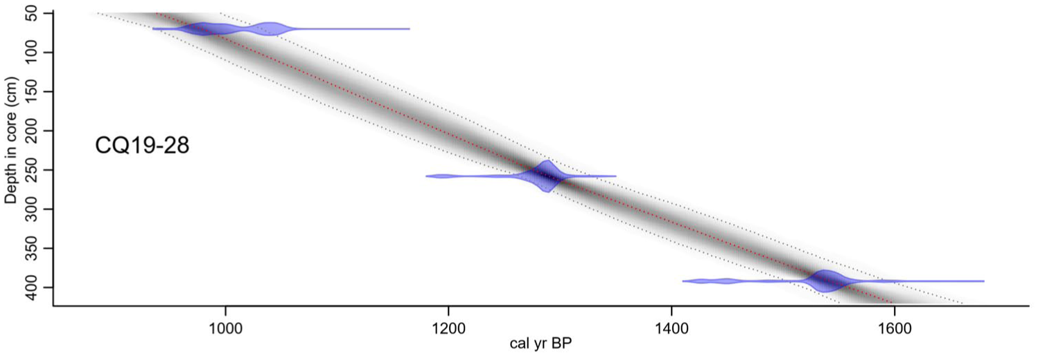
Bayesian age–depth model of the CQ19-28 sediment core created with the R package rbacon. The red dashed line represents the weighted-mean modeled age; gray dashed lines denote the 95% confidence interval. Blue tie bars show the calibrated 14C probability distributions for each dated horizon. Continuous sediment accumulation between ~1.6 and 1.0 ka cal BP is evident, supporting the interpretation of uninterrupted Late-Holocene deposition.
The chronological data from the three cores show a sequence of depositional phases as follows.
– Sediment accumulation at Dam Thuong is recorded from ~3.3 ka cal BP;
– At Cao Quy, dated horizons occur at ~2.7 ka cal BP; and
– At CQ19-28, sedimentation is recorded between ~1.6 and 1.0 ka cal BP.
These chronological and stratigraphic relationships provide the framework for interpreting the five-stage Late-Holocene evolution of the Bach Dang estuary (Figure 7).
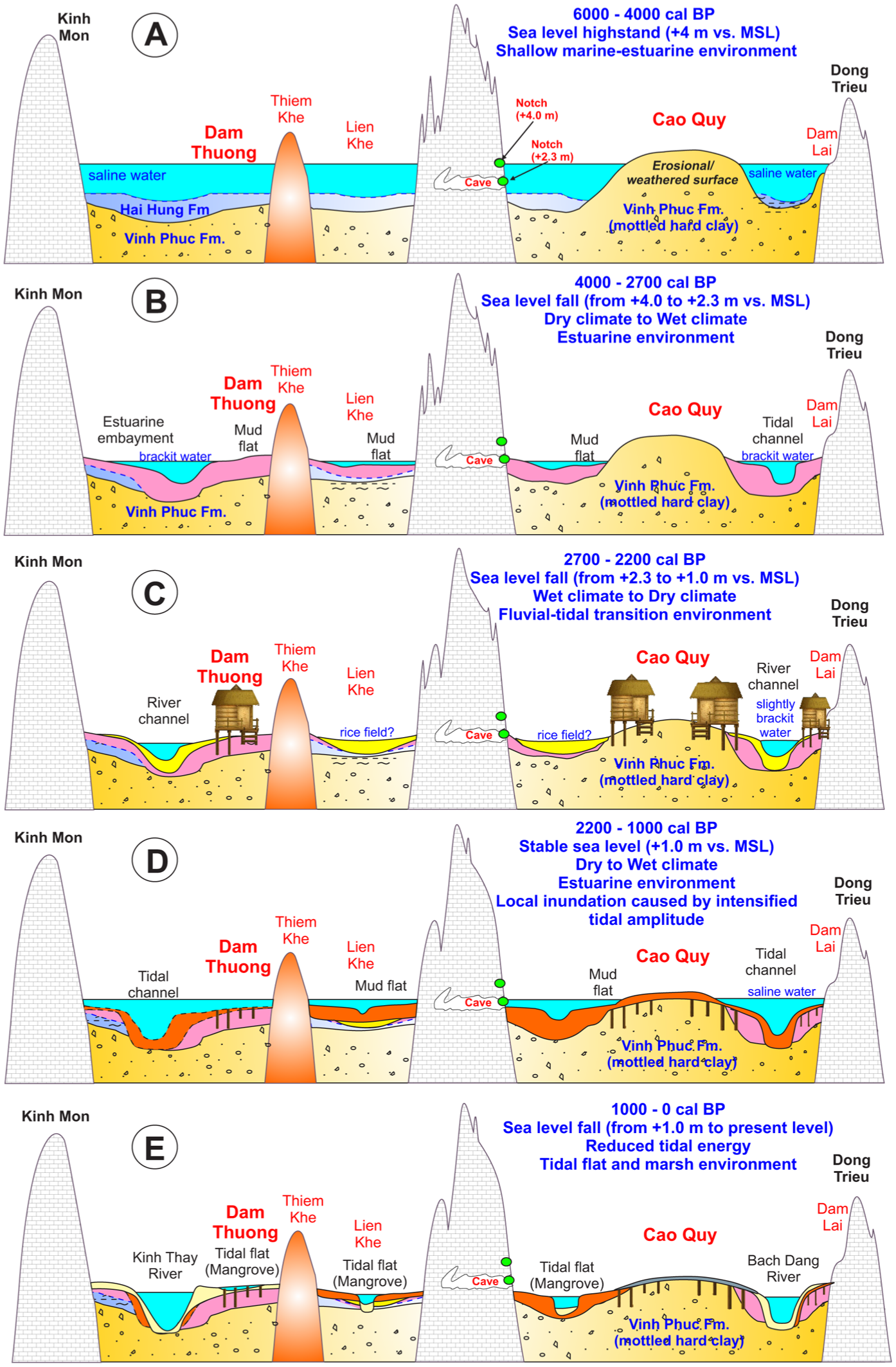
Schematic paleogeographic evolution of the Late-Holocene in the Cao Quy–Dam Thuong area (Hai Phong), northern Vietnam. (a) 6000–4000 cal BP: sea-level highstand (~4 m relative to MSL), shallow marine–estuarine environment. (b) 4000–2800 cal BP: sea-level fall (from +4 to +2 m relative to MSL), transition from dry to wet climate, estuarine environment. (c) 2800–2200 cal BP: sea-level fall (from +2 to +0.5 m relative to MSL), fluvial–tidal transition environment. (d) 2200–1000 cal BP: stable sea level (~+1 m relative to MSL), local inundation due to intensified tidal amplitude (~2.3 m). (e) 1000–0 cal BP: sea-level fall (from +0.5 m to present level), reduced tidal energy, tidal-flat and marsh environments.
Depth of the mottled hard clay surface
The mottled hard clay surface marks the upper boundary of the Vinh Phuc Formation, a late Pleistocene weathered horizon that formed under prolonged subaerial exposure prior to Holocene transgression. It is regionally continuous and serves as a distinct stratigraphic marker across both the Cao Quy and Dam Thuong areas. The surface is characterized by yellowish to reddish brown clay with mottled Fe-Mn stains and occasional root traces-features. Coring operations were generally terminated once this surface was reached (Table 1, Figure 5).
Across the Cao Quy plain, most sediment cores encountered this surface at relatively shallow depths. In the rice-field area surrounding the archeological excavations (pits H1−H3), the mottled hard clay lies 0.5−1.0 m below the ground surface, corresponding to elevations of −0.5 to 0 m relative to MSL. Around the exposed Cao Quy wooden-pile site, the surface occurs immediately below the ground level (within a few centimeters), and in some places is partially exposed due to erosion. Greater depths occur locally in small depressions-such as pit H2 and the southern cores CQ19-26 to CQ19-28, situated beside a minor tidal creek-where Holocene silts reach thicknesses of 2.8−4.5 m. Along the Bach Dang riverbank, mechanical drillings (e.g. CQ19-05, CQ19-12, CQ19-13) recorded the mottled hard clay at depths of 2.8−3.5 m (Table 1).
Supplementary TN24 cores collected in 2023–2024 beyond the Cao Quy archeological zone also show a generally shallow hard-clay surface (~0.5 m), except at TN24−1 (near a former tidal creek) and TN24−4 (within a paleo-marsh depression) where it occurs deeper. Core TN24−7, from the north bank of the Bach Dang River in Dam Lai, Quang Ninh Province-near a site where other researchers also discovered wooden piles (Figure 2; radiocarbon dated to ~2.4 ka cal BP; as reported in local media (Bao Quang Ninh, 2017), citing information provided by archeologist Bui Van Hieu)—reached 2.5 m depth without encountering the mottled hard clay. In the Gia River channel (core GIA23−12), the mottled hard clay occurs ~2 m below the riverbed; combined with the 2.8 m water depth, its top lies ~5 m below the water surface. In contrast, none of the Dam Thuong cores (e.g. DT-A, DT-C) reached the mottled hard clay even at depths greater than 5 m, with the base of the cores extending to ~−6 m relative to MSL.
The depth of the mottled hard clay surface varies across the study area, with shallow occurrences (0.5–1.0 m below ground surface) in the Cao Quy plain and greater depths (up to >5 m) in the Dam Thuong area and along river channels. Locally, thicker Late-Holocene deposits (2.8–4.5 m) are observed in depressions and near tidal creeks (e.g. pit H2, cores CQ19-26 to CQ19-28).
The elevation and distribution of this surface provide a stratigraphic framework for correlating sediment thickness and depositional patterns across the Bach Dang estuarine system.
Elevation of sea-level notches in the limestone cliffs
Two paleo-sea-level notches are preserved on a limestone cliff adjacent to a small cave, located ~800 m southeast of the Cao Quy archeological site (Figures 2 and 4). The cave extends about 100 m into the limestone hill, and two distinct erosional notches can be observed at different elevations: a shallow upper notch at ~+4.0 m relative to MSL and a lower notch at about +2.3 m relative to MSL. The lower notch is clearly developed along the inner cave wall, forming a continuous erosional groove close to the ceiling, whereas the cave floor lies well below it. Elevations were surveyed using a laser total station in 2019 (± 2 cm accuracy) and referenced to the Vietnamese National Vertical Datum (MSL at Hon Dau Station), equivalent to +1.41 m above the EGM96 geoid (Kahlert et al., 2021).
For comparison with previously published Mid-Holocene sea-level data across Northern Vietnam, all datasets were standardized to a consistent vertical framework (Table 4). The table presents the original reported values together with the standardized equivalents relative to both the Vietnamese national Mean Sea Level (MSL) and the EGM96 global geoid.
Synchronization of Mid-Holocene sea-level data in Northern Vietnam.
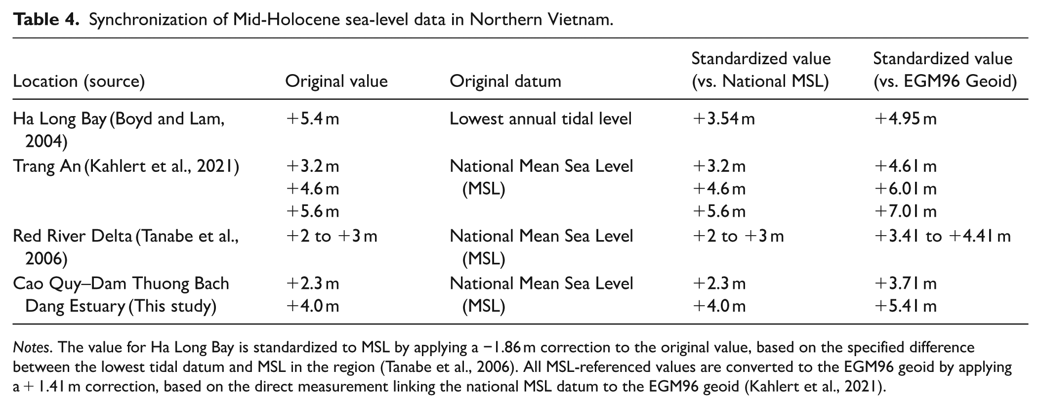
Notes. The value for Ha Long Bay is standardized to MSL by applying a −1.86 m correction to the original value, based on the specified difference between the lowest tidal datum and MSL in the region (Tanabe et al., 2006). All MSL-referenced values are converted to the EGM96 geoid by applying a + 1.41 m correction, based on the direct measurement linking the national MSL datum to the EGM96 geoid (Kahlert et al., 2021).
Discussion
The chronological context of the Cao Quy and Dam Thuong sites
The most definitive outcome of this study is the establishment of a robust chronological framework for the wooden-pile structures at Cao Quy and Dam Thuong. All eight AMS 14C ages obtained from these sites cluster tightly between ~2515 and 2301 cal BP (~566−352 BCE; Table 2), providing compelling evidence that the two localities were occupied during a single cultural phase. This timeframe securely places their construction and use within the late Dong Son period, thereby refuting the widely circulated-but scientifically unsupported-interpretation that the piles belonged to the 13th-century CE naval battlefields of the Tran Dynasty. In contrast, the battlefield stakes excavated at Yen Giang and Dong Ma Ngua have been radiocarbon-dated to CE 1270–1400 (Kimura et al., 2014), more than 1500 years younger than the structures investigated here.
The radiocarbon results also reveal a remarkable spatial and temporal coherence. The Cao Quy and Dam Thuong localities-separated by only ~5 km along the Bach Dang estuarine margin-share overlapping calibrated age ranges (~2515−2301 cal BP), indicating that they were contemporaneous and probably part of a unified settlement system within the lower Red River Delta. Sediment ages and stratigraphic relations suggest that the deposits at Cao Quy, closer to the modern shoreline, represent a slightly younger phase of accumulation (Figure 5). This pattern accords with a progressive seaward migration of habitation and depositional surfaces during Late-Holocene delta progradation. The dated piles from Cao Quy (2440 ± 20 to 2270 ± 15 BP; 566–355 BCE) and Dam Thuong (406–352 BCE; Table 2) thus document a short-lived construction episode within this dynamic deltaic landscape.
The structural attributes of the piles-flat bases, chisel marks, and mortise-like recesses (Section 3.2)—strongly support their interpretation as foundation posts for stilt-house dwellings rather than sharpened defensive stakes. Comparable joinery and woodworking techniques, including locked mortise-and-tenon joints, have been described from Dong Son boat remains and timber artifacts (Bellwood et al., 2007), demonstrating that late Dong Son carpenters possessed advanced technical skills in shaping and interlocking timber components.
Independent archeological evidence from the surrounding region further corroborates this late Dong Son framework. The radiocarbon ages coincide with the celebrated Viet Khe boat burial (~10 km southeast of Cao Quy), securely dated to the fifth century BCE (Tan, 1994). Comparable wooden piles at Dam Lai, on the opposite bank of the Bach Dang River, have yielded ~2.4 ka cal BP ages, suggesting a regionally extensive phase of settlement and architectural activity along estuarine-tidal margins of the lower Red River system. Taken together, the evidence suggests that the Late-Holocene Bach Dang estuary sustained a vibrant network of tidal-margin communities whose waterborne livelihoods, trading activities, and incipient wet-rice cultivation flourished under stable but dynamic tidal regimes (Liem, 2024).
Alternative hypotheses proposing that the Cao Quy piles were reused materials from earlier wooden structures-such as temples or communal halls later converted into battlefield stakes-are inconsistent with both chronological and cultural evidence. (1) The 14C ages (~2400 BP) pre-date the Tran Dynasty by over 1500 years, and there is no credible example of intact wooden architecture surviving that long in humid tropical conditions without continuous anoxia. (2) The Dong Son period (~700−200 BCE) precedes the emergence of Buddhist or Taoist temple architecture in Vietnam, making such structures improbable. (3) From a practical standpoint, 13th-century builders would have found it far easier to fell new timber locally than to retrieve decayed posts from ancient sediments. These points collectively refute the “reuse” hypothesis and demonstrate that the Cao Quy and Dam Thuong piles represent in-situ domestic or settlement-related foundations. Their exceptional preservation is best explained by rapid burial in fine estuarine muds under anaerobic conditions that inhibited decay and allowed these wooden features to survive for more than two millennia.
Although the radiocarbon determinations fall within the broad calibration plateau of the IntCal20 curve (~2750−2350 cal BP; Reimer et al., 2020), the tight clustering of all eight samples still defines a narrow construction window during the fifth−fourth centuries BCE, corresponding to the middle-to-late Dong Son (late Van Lang) phase of Northern Vietnamese prehistory. This was the terminal Bronze Age of Mainland Southeast Asia, immediately preceding the emergence of the Au Lac polity (~200 BCE) centered at Co Loa (Higham, 1996; Tan, 1994).
Within this broader cultural landscape, northern Vietnam functioned as the core region of the Dong Son civilization, whose technological and artistic traditions spread widely across Mainland and Island Southeast Asia-from southern China (Yunnan and Guangxi) to Laos, Cambodia, Thailand, Peninsular Malaysia, and Indonesia (Bellwood, 2007; Higham et al., 2011; Liem, 2024; Tan, 1994). The Dong Son culture thus marks both the pinnacle of the Southeast Asian Bronze Age and a key vector for regional social complexity and maritime interaction. The emergence of large-scale wooden constructions such as the Cao Quy pile field reflects this high level of organization and the ability of elite groups-who controlled bronze production and exchange-to mobilize labor for ambitious communal works. Consequently, the Cao Quy structure may be viewed as a tangible manifestation of elite-driven social coordination within a tide-dominated estuarine environment, foreshadowing the protohistoric state formation that followed in Northern Vietnam.
Late-Holocene environmental evolution in the Bach Dang Estuary
The integration of sedimentological, chronological, and geomorphic data-including the newly identified paleo-sea-level notches at Cao Quy-reveals a coherent sequence of environmental changes that link the local stratigraphy to the broader Holocene sea-level history of Northern Vietnam. Five evolutionary stages are distinguished (Figure 7). These stages are interpreted within the delta-wide framework of stratigraphy (Duong et al., 2020; Tanabe et al., 2003, 2006; Yen et al., 2021), taking into account both climatic pacing (Griffiths et al., 2020) and geomorphic indicators from the Trang An-Ha Long region (Boyd and Lam, 2004; Kahlert et al., 2021; Rabett et al., 2023).
Mid-Holocene highstand and shallow marine-estuarine deposition (6000−4000 cal BP)
The Holocene environmental evolution of Northern Vietnam was characterized by rapid sea-level rise during the early Holocene, followed by a Mid-Holocene highstand and subsequent regression after ~4 ka BP (Tanabe et al., 2003, 2006). Two marine notches preserved on a limestone cliff near Cao Quy provide direct geomorphic evidence for this highstand. The upper notch, at +4.0 m relative to MSL (Figures 4 and 7a), corresponds closely to the peak highstand observed at Trang An (+4.6 m) and Ha Long Bay (+3.5 m, after datum correction; Boyd and Lam, 2004; Kahlert et al., 2021; Tanabe et al., 2006). However, local water levels in the Bach Dang estuary may have been significantly modulated by tidal amplification and estuarine resonance, and therefore may not directly correspond to regional relative sea-level positions. Consequently, these notches should be interpreted with caution and are not treated as strict sea-level index points. Within this context, the upper notch likely formed when relative sea level was near +4 m relative to MSL around 6−5 ka cal BP, marking the maximum marine transgression. At that time, the Bach Dang valley was a semi-enclosed tidal embayment, receiving fine-grained marine-estuarine sediments of the Hai Hung Formation. This highstand phase therefore represents the deepest marine inundation in the region, consistent with widespread Mid-Holocene transgressive deposits throughout the Red River Delta (Duong et al., 2020; Funabiki et al., 2012; Tanabe et al., 2003, 2006; Yen et al., 2021).
Sea-level fall and estuarine infilling during a dry-to-wet climatic transition (4000−2700 cal BP)
Following the Mid-Holocene highstand, relative sea level in northern Vietnam likely fell from about +4.0 m to ~+2.3 m relative to MSL, possibly indicated by the lower marine notch at Cao Quy (Figures 4 and 7b). This regression reshaped the Bach Dang estuary into a network of shallow embayments and tidal wetlands.
Pollen sediment cores across the Red River Delta (Duong et al., 2020) document a widespread contraction of mangrove forests and a gradual retreat of brackish-water environments as sea level began to fall after the Mid-Holocene highstand. The Trang An record further shows that mangroves could persist long after regional regression (O’Donnell et al., 2020); by analogy, the Cao Quy-Dam Thuong sector likely remained a brackish, mangrove-fringed wetland even after the main coastline had advanced seawards. Regional reconstructions of Late-Holocene paleoshorelines (Duong et al., 2020; Yen et al., 2021) confirm that by ~3.7 ka cal BP the shoreline had prograded markedly seaward from its Mid-Holocene position, forming a complex mosaic of tidal flats and back-swamp wetlands. This progradation coincided with a major weakening of the Asian summer monsoon and episodic “megadroughts” between ~5.1 and 3.3 ka cal BP (Griffiths et al., 2020), when reduced precipitation and river discharge diminished sediment supply and favored stabilization of emergent surfaces. As monsoonal humidity increased again after ~3.3 ka cal BP, renewed fluvial input and tidal reoccupation initiated progressive infilling of residual estuarine basins across the Bach Dang region. A generation of relict coastal ridges dated to ~3.0−2.5 ka (Yen et al., 2021) coincides with the radiocarbon ages of the Cao Quy and Dam Thuong wooden piles (~2.5-2.3 ka cal BP), placing the Dong Son settlement on or near an emergent deltaic lobe formed during this initial regressive phase-a strategically located, resource-rich terrain along estuarine channels and tidal inlets.
The earliest record of this phase is captured in the low-lying Dam Thuong basin, where the DT-A core records the onset of fine-grained tidal sedimentation between ~3.3 and 3.0 ka cal BP (Figure 5). The sequence comprises dark-gray to light-gray silt with thin reddish interbeds reflecting episodic fluvial influx. The fine-sand fraction averages ~8%, magnetic susceptibility ~30 × 10−5 SI, and OM content increases upward from 6 to 10 wt. %, indicating a gradual reduction in hydrodynamic energy and enhanced organic productivity within a semi-enclosed estuarine setting.
Sedimentation later occurred in the eastern, relatively higher-elevation margin of the delta, exemplified by the Cao Quy area, where the CQ19-H2 core preserves younger tidal-flat deposits dated to ~2.75 ka cal BP (Figure 5). The core consists of dark greenish-gray to dark-gray silt with faint cross-lamination and alternating thin laminae of fine sand and silt (0.3−0.5 cm). The fine-sand fraction averages ~12%, magnetic susceptibility peaks at ~30 × 10-5 SI in the lower part and declines upward, and OM content (5−9 wt. %) attains a maximum of ~9 wt. % at 1.4 m depth-signifying a shift from moderately energetic estuarine to quieter tidal-flat conditions.
Although the overall trend during this interval was one of sea-level lowering, the deposition of the CQ19-H2 unit around 2.8-2.7 ka cal BP may reflect a short-lived phase of enhanced flooding or tidal inundation linked to a regional precipitation maximum following the Mid-Holocene dry phase (Griffiths et al., 2020). Such transient high-water conditions could have resulted from increased monsoonal rainfall, amplified tidal amplitude, or stronger summer-monsoon winds that transported additional sediment from outer deltaic and near-shore sources into the Bach Dang estuary. This brief hydrodynamic resurgence likely promoted renewed sediment aggradation on the slightly elevated paleo-surfaces of Cao Quy.
Fluvial-tidal transition and Dong Son human occupation (2700−2200 cal BP)
By ~2.7 ka cal BP, relative sea level had fallen from about +2.3 to +1 m MSL, producing a complex fluvial-tidal mosaic within the inner Bach Dang estuary. As accommodation space decreased, shallow tidal depressions filled while gently undulating paleo-highs of the mottled-hard-clay (Vinh Phuc Formation) surface emerged as semi-stable platforms intermittently exposed above high tide. These elevated grounds-particularly beneath the modern Cao Quy site-offered firm, moderately drained surfaces suitable for stilt-house settlement (Figure 7c).
Radiocarbon ages of the wooden piles from Cao Quy and Dam Thuong (~2.5−2.3 ka cal BP; ~566−353 BCE) coincide with this phase of geomorphic stabilization following the major Mid-Holocene regression (Duong et al., 2020; Tanabe et al., 2006). Stratigraphic evidence shows that some piles were driven directly into the oxidized hard-clay surface at Cao Quy site, while others penetrated thin estuarine muds (at both Cao Quy and Dam Thuong sites) deposited shortly beforehand-implying construction soon after tidal sedimentation had waned and the ground became firm enough for habitation. By this time, relative sea level had likely fallen from the +2.3 m MSL notch formed earlier (~4.0−2.7 ka cal BP) to around +1 m MSL. The stilt-houses, erected on surfaces at above +1−2 m MSL, thus stood just above the contemporaneous high-tide level-balancing protection from flooding with convenient access to tidal waterways.
Archeological data and paleoenvironmental context together portray a community highly adapted to estuarine life. Boat remains from other Dong Son-period archeological sites (Bellwood et al., 2007) indicate advanced plank-built craft and navigation skills, consistent with the vessels depicted on Dong Son drums. Situated near the estuarine mouth, the Cao Quy-Dam Thuong complex likely functioned as both a domestic settlement and a river-harbor hub within a wider waterborne exchange network. The combination of stable, moderately dry tidal surfaces, reduced flooding frequency, and abundant aquatic resources created ideal conditions for semi-permanent occupation.
Speleothem δ18O records from northern Laos (Griffiths et al., 2020), show a gradual weakening of the Southeast Asian summer monsoon after ~2.7 ka cal BP, leading to drier but more stable conditions across mainland Southeast Asia. Complementary evidence from Quan Lan Island (Briles et al., 2019) shows parallel landscape transformation around 2.8 ka BP, when forest clearance and cultivation intensified. While deltaic communities adapted to emergent estuarine surfaces, nearby island populations were simultaneously reshaping forested ecosystems for agriculture. Together, these records highlight a regional Dong Son pattern of environmental modification and demographic expansion across the Red River coastal zone. This climatic moderation likely fostered geomorphic stability in the Bach Dang lowlands, allowing the Dong Son communities to thrive during a short-lived equilibrium between regression and subsequent tidal expansion (~2.2 ka cal BP).
Their expansion into such low-lying estuarine terrain reflects a deliberate occupation of newly emerged deltaic land following Late-Holocene regression. As the Red River delta continued to prograde seaward, Dong Son populations advanced with it, supported by innovations in wet-rice agriculture (Masanari, 2005) that enabled larger labor forces and communal construction. The Cao Quy-Dam Thuong complex thus embodies both technological sophistication and agrarian surplus, illustrating how Dong Son communities transformed environmental opportunity into social capability.
Collectively, geomorphic, chronological, and archeological evidence demonstrates that the Dong Son occupation of Cao Quy and Dam Thuong was tightly coupled to Late-Holocene coastal evolution. The clustered AMS 14C ages (~2515−2301 cal BP) mark a single settlement horizon representing a rare Bronze-Age adaptation to a tide-dominated environment-showing how ancient societies along the Red River delta margin balanced hydrodynamic risk with access to estuarine resources under gradually falling sea levels.
Post-Dong Son environmental transition and Late-Holocene estuarine stabilization (2200−0 cal BP)
Following the late Dong Son occupation (~2.5−2.3 ka cal BP), the Bach Dang estuary underwent a complex sequence of hydrodynamic and sedimentary changes that marked the transition from a high-energy, tide-dominated system to a low-energy tidal-flat-marsh landscape. These transformations, recorded in multiple sediment cores (e.g. CQ19-28 and TN24 core series), reflect the interplay between sea-level fluctuations, tidal amplification, and progressive sediment infilling (Figure 7d and e).
Intensified tidal amplitude and renewed inundation (2200−1000 cal BP)
After the Dong Son phase, relative sea level had already stabilized near ~+1 m MSL, yet the estuary experienced enhanced tidal forcing-likely approaching the modern spring range (modern range ~3.5−4 m, Vinh et al., 2018). This amplification was probably driven by estuarine constriction, resonance, and deltaic reorganization. Radiocarbon ages from the CQ19-28 core indicate continuous accumulation from ~1.6 to 1.0 ka cal BP with sedimentation rates of 4−6 mm yr−1 (Figure 6). Alternating reddish-gray silts with ~6% fine sand, magnetic susceptibility of 40−50 × 10−5 SI, and 6−10% OM content (Figure 5) document deposition in tidal-flat and marsh settings periodically influenced by river input and subaerial exposure. The upward increase in rootlets and OM reflects a gradual shallowing toward vegetated flats. In addition, the radiocarbon sample LK1 (leaf and sediment) near the base of core CQ19-28 developed a distinct odor of hydrogen sulfide (H2S) when treated with hydrochloric acid during laboratory preparation. This reaction indicates the prior presence of sulfate derived from seawater, which was reduced to sulfide under anoxic conditions at shallow burial depths. Part of this hydrogen sulfide was subsequently consumed during the formation of pyrite and other metal sulfides. Such geochemical signatures point to active marine or brackish influence during deposition, confirming that the site remained under periodic seawater inundation at the time of sediment accumulation (Arndt Schimmelmann, pers. comm.).
Although relative sea level remained below ~+1 m relative to MSL, tidal resonance likely maintained effective inundation of lowlands, causing localized flooding and burial of older habitation surfaces beneath anoxic muds. This renewed tidal phase thus represents the final stage of Holocene estuarine infilling prior to full stabilization.
Reduced tidal influence and tidal-flat/marsh development (1000−0 cal BP)
After ~1.0 ka cal BP, relative sea level approached its modern position, leading to declining tidal energy and geomorphic stabilization. The upper 50 cm of CQ19-28 consists of fine gray silts rich in roots and plant debris, showing pedogenic alteration and oxidation under intermittent exposure. Magnetic susceptibility decreases sharply, consistent with low-energy micro-tidal deposition occasionally interrupted by flooding. Similar facies in TN24−1, TN24−4, and TN24−7 reveal shallow mottled-clay surfaces overlain by thin organic-rich silty muds interpreted as paleo-marsh deposits. This phase corresponds to the terminal stage of Late-Holocene regression (Duong et al., 2020; Tanabe et al., 2006), when mangrove colonization, peat accumulation, and soil formation transformed the active estuary into a low-relief coastal plain. Subsequent anthropogenic modification-rice cultivation, aquaculture, and drainage-further reshaped the near-surface stratigraphy.
Possible mechanisms of rapid burial and tidal amplification
Sedimentological and geomorphic observations indicate that the transition from habitable Dong Son floodplains to tidal mudflats appears to have occurred relatively abruptly after ~2.2 ka cal BP. The burial of the Cao Quy wooden-pile area beneath estuarine muds (e.g. near core CQ19-28) appears to reflect a relatively short-lived but high-magnitude inundation phase, possibly lasting for decades to a few centuries. Several interrelated mechanisms may explain this environmental shift, with tidal amplification likely playing a primary role:
− A minor contribution from Late-Holocene sea-level variability, perhaps associated with regional hydro-isostatic adjustment following Mid-Holocene shoreline retreat (Mann et al., 2019);
− Progressive tidal amplification driven by estuarine narrowing, resonance, and backwater effects during ongoing infilling;
− Climatic variability, including a potential decline in rainfall around ~2.2 ka cal BP following a pluvial maximum at ~2.8−2.7 ka cal BP (Griffiths et al., 2020), which might have altered freshwater discharge, salinity gradients, and sediment-flocculation dynamics within the estuary;
− The development of barrier-island and land-bridge systems (Cat Hai island, Ha Nam island, Do Son peninsular) that may have modified tidal exchange and enhanced local high-water levels.
Modern analogs from the Cam-Nam Trieu estuary, the present-day continuation of the Bach Dang system, illustrate similar physical processes. In this setting, an estuarine turbidity maximum typically develops where fresh and saline waters converge, concentrating suspended sediment and promoting rapid mud deposition (Vinh et al., 2018). At intermediate salinities (~10−15 psu), enhanced flocculation-often mediated by estuarine microorganisms-appears to accelerate the settling of fine-grained aggregates (Mari et al., 2012). These processes may collectively account for the homogeneous, anoxic mud layer that ultimately enclosed the wooden piles at Cao Quy and Dam Thuong, enabling their remarkable preservation.
In addition, variations in sand and silt fractions provide further insight into depositional energy and sediment transport processes in the Bach Dang estuary. In coastal and estuarine environments, grain-size characteristics have been widely used to reconstruct shoreline dynamics, relative sea-level changes, and associated shifts in depositional environments (Rosentau et al., 2020). Importantly, studies from the Baltic Sea region demonstrate that archeological structures in coastal settings can be rapidly buried by fine-grained sediments as a result of shoreline displacement and estuarine or lagoonal infilling, without requiring catastrophic forcing (Nirgi et al., 2022). In our cores, the generally low sand content and only minor fluctuations indicate predominantly low- to moderate-energy tidal conditions, while any transient increases in sand fraction may reflect short-lived high-energy episodes, such as enhanced tidal currents. The dominance of fine-grained, homogeneous sediments is therefore consistent with rapid burial under tidally influenced, low-energy conditions, similar to processes documented in other Holocene coastal systems. At the same time, Red River deltaic reorganization around ~2 ka cal BP is inferred to have redirected sediment discharge toward the Ba Lat distributary (Tanabe et al., 2003, 2006), thereby reducing sediment supply to the Bach Dang estuary and potentially enhancing tidal resonance within its narrowing channels.
Alternative high-magnitude mechanisms, such as tectonic subsidence or tsunami inundation, can be considered to explain the rapid burial of the wooden-pile sites. However, these processes are considered unlikely in the Bach Dang region. The study area is located within a tectonically stable sector of northern Vietnam, where no significant Late-Holocene deformation has been documented (Nguyen Viet et al., 2025; Trinh et al., 2012). In addition, there is no historical or geological evidence for tsunami activity affecting the northeastern margin of the Red River Delta during the Late-Holocene.
Furthermore, the sedimentary record does not display features typically associated with sudden catastrophic events, such as erosional bases, chaotic bedding, or coarse-grained overwash deposits. Instead, the observed fine-grained, homogeneous, and organic-rich mud layers are more consistent with rapid accumulation under enhanced tidal conditions. These observations support the interpretation that the burial of the Cao Quy and Dam Thuong sites resulted primarily from internally driven estuarine processes rather than external high-energy events.
Integrated stratigraphic, chronological, and geomorphic data delineate a coherent Late-Holocene trajectory:
– Mid-Holocene marine transgression (6–4 ka cal BP): sea level + 4 m relative to MSL; deposition of marine-estuarine Hai Hung muds.
– Regression and early estuarine infilling (4.0−2.7 ka cal BP): transition to humid climate; formation Dam Thuong (DT-A core) and early Cao Quy (CQ19-H2) facies.
– Fluvial-tidal phase (2.7−2.2 ka cal BP): relative sea level + 2.3–1 m above MSL; Dong Son stilt-house settlements on paleo-highs.
– Amplified tidal phase (2.2−1.0 ka cal BP)-tidal resonance, rapid accretion, burial of settlements (CQ19-28 sediment core).
– Final stabilization (1.0–0 ka cal BP)-declining tidal energy, organic accumulation, and marsh formation under near-modern sea level.
Collectively, these records document the transformation of a tide-dominated estuary into a stable tidal-flat-marsh plain shaped by the combined effects of relative sea-level change, monsoon variability, and local topographic controls. This sequence provides a robust stratigraphic and paleoenvironmental framework for understanding human-environment interactions and cultural resilience along the northeastern margin of the Red River Delta.
Conclusions
This study integrated geoarchaeological, sedimentological, chronological, and geomorphic evidence to investigate the age, context, and environmental setting of the wooden-pile sites at Cao Quy and Dam Thuong, and to reconstruct the Late-Holocene evolution of the Bach Dang Estuary in northern Vietnam. The main conclusions are as follows:
Radiocarbon dating provides robust chronological control for the wooden structures. Eight AMS 14C ages from both sites cluster tightly between ~2515 and 2301 cal BP (~566−352 BCE), placing their construction within the late Dong Son period and contradicting the popular-but scientifically unsupported-association with the 13th-century CE Tran-Dynasty battles. The piles are interpreted as in situ foundation posts of stilt-house dwellings rather than sharpened defensive stakes.
The Dong Son settlements were likely established on emergent paleo-highs of the late Pleistocene Vinh Phuc Formation during a brief window of opportunity (~2.7−2.2 ka cal BP) characterized by relative sea-level fall, geomorphic stability, and a moderately dry climate. These settings suggest that settlements were located on slightly elevated surfaces within a fluvial-tidal mosaic, balancing flood protection with access to estuarine waterways.
The exceptional preservation of the wooden piles most plausibly reflects rapid local burial following ~2.2 ka cal BP. A phase of accelerated fine-grained sedimentation-possibly driven by progressive tidal amplification associated with estuarine narrowing, resonance, and backwater effects-led to the sealing of abandoned settlements beneath thick anoxic muds. This represents a key environmental threshold when formerly habitable floodplains were transformed into tidal-flat and marsh environments. A contemporaneous reorganization of the Red River delta around ~2 ka cal BP likely redirected sediment discharge toward the Ba Lat distributary, thereby starving the Bach Dang estuary of fluvial input and potentially enhancing tidal resonance within its narrowing channels. The combined influence of tidal amplification and sediment starvation could plausibly have produced the rapid inundation and burial that terminated Dong Son occupation in the area.
A five-stage model of landscape transformation is proposed, constrained by two newly identified paleo-sea-level notches at +4.0 m and +2.3 m MSL. This sequence traces the transition from a Mid-Holocene marine embayment to the present coastal plain, offering a refined paleoenvironmental framework for a previously under-documented sector of the Red River Delta,
The results resolve a long-standing archeological question while illustrating how short-term coastal dynamics—tidal amplification, sediment redistribution, and relative sea-level variability—shape both human settlement patterns and the preservation of archeological records.
The results resolve a long-standing archeological question while illustrating how short-term coastal dynamics—tidal amplification, sediment redistribution, and relative sea-level variability—shape both human settlement and the preservation of archeological records. The Dong Son communities were not only accomplished bronze metallurgists but also adapted to a dynamic tide-dominated environment, where both opportunities and environmental constraints contributed to the formation and preservation of one of the most distinctive archeological records of Northern Vietnam. More broadly, this study provides a well-constrained example of how rapid sedimentation and coastal morphodynamic changes can govern human–environment interactions in tide-dominated estuarine systems, offering a useful analog for similar coastal and deltaic environments worldwide, particularly in monsoon-influenced regions.
Footnotes
Acknowledgements
This research has been done under the research project QG.23.17 of Vietnam National University, Hanoi. We thank Arndt Schimmelmann at Indiana University for his support with radiocarbon dating and insights throughout the study. We are grateful to Ingmar Unkel (Heidelberg University) for his assistance with age-depth modeling of the sediment cores. We also thank Prof. Nguyen Tai Tue (Faculty of Geology, VNU University of Science, VNU-HUS) for providing field equipment and for leading the initial sediment coring campaign. We would like to thank our colleagues at VNU-HUS for their valuable assistance with field surveys and the initial description of the sediment cores. We would like to express our sincere appreciation to Prof. Vu Minh Giang and Prof. Mai Trong Nhuan (VNU) for their invaluable support in facilitating access to the study area and granting research permission, as well as for their kind assistance in facilitating communication and coordination between our research team, the archeological excavation team, and local authorities. We are also sincerely grateful to Dr. Bui Van Hieu (Institute of Archaeology, Vietnam Academy of Social Sciences) and his team for their generous support and collaboration during field sampling activities at the archaeological excavation sites. We are grateful to the anonymous reviewer for their constructive and helpful comments, which significantly improved the quality of this manuscript.
Ethical considerations
This study did not involve any human participants, animals, or sensitive personal data requiring ethical approval.
Consent to participate
Not applicable.
Author contributions
Funding
The authors disclosed receipt of the following financial support for the research, authorship, and/or publication of this article: Vietnam National University, Hanoi (VNU Hanoi), project code QG.23.17
Declaration of conflicting interests
The authors declared no potential conflicts of interest with respect to the research, authorship, and/or publication of this article.
Data availability statement
Data supporting the findings of this study are available from the corresponding author upon reasonable request.*