
Abstract
The geochemical and palynological study of a well-radiocarbon-dated core from the “Les Comailles” peat bog, located in the vicinity of slag heaps in the former iron-metallurgy district of Puisaye (Bourgogne-Franche-Comté region, France), highlights the impact of metallurgical activities on vegetation cover from 2000 cal. BC to cal. AD 1740. The physico-chemical characterization of the peat bog demonstrated its reliability to be used as a chronological archive of past environmental changes. The study recorded evidence of atmospheric emissions of several metals, including arsenic, lead, or zinc, during the Late Bronze Age, even though no archaeometallurgical sites are currently known in the Puisaye district before the Early Iron Age, revealing the possible existence of punctuated bronze metallurgy in Puisaye. Forest clearance of Quercus was evidenced during the Second Iron Age and is related to the intensification of iron-metallurgy and crop cultivation. Comparison of palynological data from the Comailles core with charcoal analyses from slag heaps in the Puisaye district, supported the selection of wood for charcoal production during the Roman Empire and the Middle Ages, as some species present in the landscape are absent in anthracological spectra. We hypothesize that there was a spatial separation between metallurgy and crop activities in Puisaye. Compositional Data Analysis made on 13 trace elements (arsenic, cadmium, cobalt, chromium, copper, lanthanum, nickel, lead, rubidium, antimony, tin, zinc and zirconium) also highlighted two main changes of geochemical composition of peat samples, dated to the beginning of the Late Middle Ages and Modern Times, that could be related to archeologically known changes in iron-metallurgy processes and organization of iron-smelting sites at a regional scale. As forest cover inhibits identification of past settlements, further investigation is advised to identify former rural settlements.
Keywords
Introduction
At a global scale, trace metal (TM) contamination of ecosystems by anthropogenic activities began with the control of fire and really increased from the Metal Ages (Nriagu, 1996). Indeed, smelting processes induce the emission of large amounts of TMs into the atmosphere, which may be deposited in aquatic and terrestrial ecosystems. Peat bogs serve as valuable archives for tracing such contamination, as their acidic conditions lead to the immobilization of atmospherically deposited TMs. These could, in turn, be used as chronological markers (Allan et al., 2013; Bindler, 2006; Longman et al., 2018; Nieminen et al., 2002; Shotyk, 1988).
Besides the emission of TMs and the potential long-term ecosystem contamination (Camizuli et al., 2014; Mariet et al., 2017a, 2017b), previous paleoenvironmental studies showed that metallurgical activities generally lead to drastic changes in the landscape. A high demand for charcoal driven by smelting activities can bring about increased forest openness (Iles, 2016), as shown by Mariet et al. (2018b) in the Vosges Mountains, where it has been linked to the heavy exploitation of beech for use in blast furnaces in the Middle Ages. However, some palynological studies, undertaken on natural archives near prehistoric mining centers in Europe, showed that the impact of attested mining activities did not always cause irreversible changes in vegetation composition (Breitenlechner et al., 2010; Mighall et al., 2017; Szymczyk and Nita, 2021; Viehweider et al., 2015). Becker et al. (2020) even demonstrated, via a spatio-temporal model of woodlot availability based on archeological data, that the decline of local metallurgy in Elba Island during the first century AD was not linked to a lack of wood for charcoal production, as has long been assumed. Conversely, forest clearing can stem from causes unrelated to metallurgy, such as changes in demography and social organization leading to higher need for wood as fuel or construction material, or changes in agro-pastoral activities (Karlsson et al., 2015; Mariet et al., 2016). Although impacts of metallurgical activities on surrounding vegetation are therefore complex, multi-proxy paleoenvironmental studies, coupling geochemistry and palynology, have reliably traced metallurgical activities near former districts and their impact on vegetation in numerous states in Europe, in France (Jouffroy-Bapicot et al., 2007; Mariet et al., 2016, 2018b; Monna et al., 2004; Py et al., 2014), in Austria (Breitenlechner et al., 2010, 2013; Viehweider et al., 2015), in the United Kingdom (e.g. Mighall et al., 2006), in Spain (e.g. Cortizas et al., 2005), and in Sweden (e.g. Bindler et al., 2011; Karlsson et al., 2016).
Recently, an archeological research program (“Iron-metallurgy in Bourgogne-Franche-Comté before the blast furnace. Organization and circulation of products”, coord. Marion Berranger) has been conducted to study ancient iron (Fe)-metallurgy in the Bourgogne-Franche-Comté region (France). Indeed, one of the most active former Fe-metallurgical district of Europe for the Iron Age and the Antiquity is known there: the Puisaye district. Here metallurgical activities, dated from the Early Iron Age to Modern Times, underwent several technological changes (Berranger et al., 2023). Given the scale of activity, this continuous period of metallurgy must have exerted strong pressure on woodland biomass and cover, and may therefore have induced significant environmental changes, comparable to those demonstrated by Tolksdorf et al. (2015) in Eastern Germany during the Middle Ages. The large consumption of wood in Puisaye is attested by the presence of numerous charcoals on slag dumps, some of which have been studied to identify the vegetal taxa used in bloomery furnaces (Girardclos and Jeannot, 2019).
Following these first investigations and to gain a broader understanding of the anthropogenic impacts at the territory scale, a multi-proxy study of a peat core sampled in the Puisaye district was conducted, documenting past vegetation, wood use and emissions of TMs over time. By coupling geochemistry to trace emissions of TMs, palynology to reconstruct landscape changes, and archeological data to establish the chronology of metallurgical activities, this study aims to trace the anthropogenic pressure on vegetation in a district of long-term metallurgy, from the Bronze Age to cal. AD 1750.
Material and methods
Study site
The study area lies within the natural region of Puisaye, which corresponds to the north-western part of the Bourgogne-Franche-Comté region in France (Figure 1a). The Puisaye is a low-elevation plateau, situated between 200 and 300 m a.s.l., at the southern limit of the Bassin Parisien. It has a substratum composed of sandy clays from the Cretaceous period, which gives rise to a high proportion of hydromorphic soils (Bardet et al., 2008). This region forms a contact zone between oak-dominated forests in the west and beech-dominated forests in the east (Figure 1b).
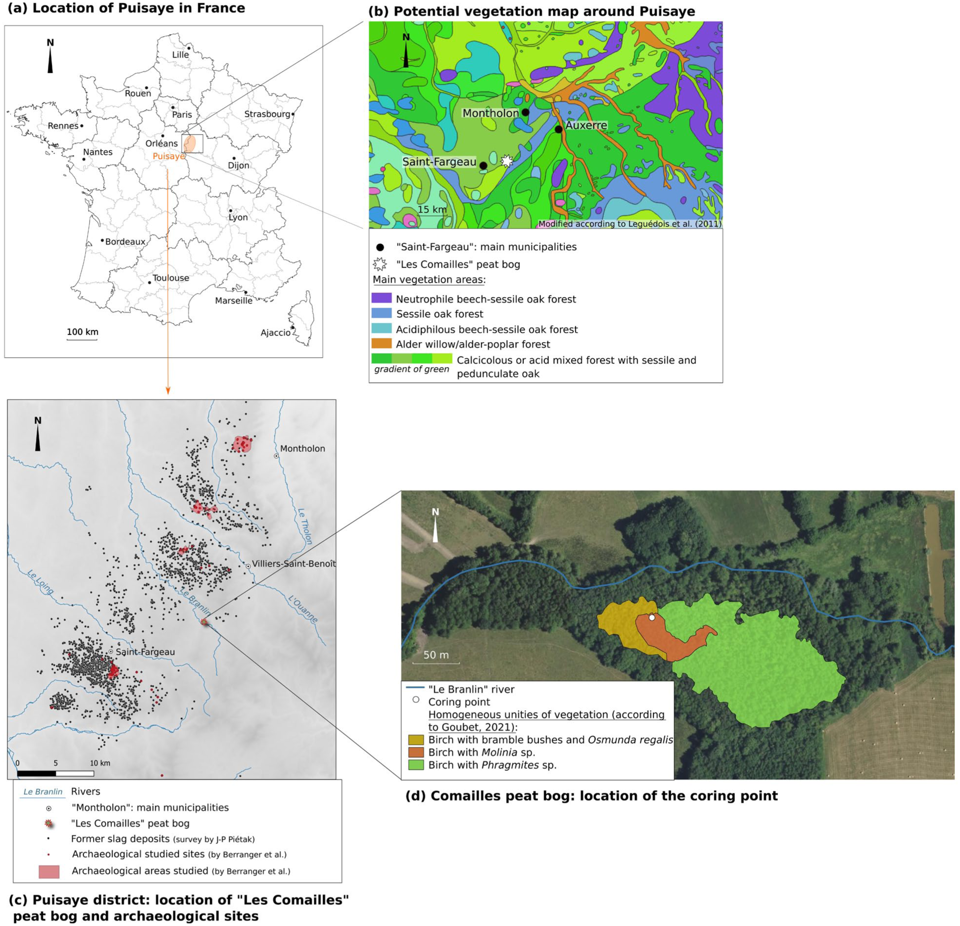
(a) Location map of the natural region of Puisaye, (b) potential vegetation map around Puisaye according to Leguédois et al. (2011), (c) location map of “Les Comailles” peat bog in the Fe-metallurgy district of Puisaye and (d) location map of the coring point in “Les Comailles” peat bog with homogeneous unities of vegetation according to Goubet (2021).
The coring site, named “Les Comailles” (N47°39.686′, E003°13.429′, 220 m a.s.l.), is located in an alluvial context, south of the Branlin river (Figure 1c), marked by a mosaic of wetlands, including a peat bog (Figure 1d). Vegetation of this peat bog is currently composed of Alnus glutinosa, Betula pubescens, Salix sp., and rich ground flora including Carex paniculata, Carex rostrata, Vitis vinifera, Sphagnum sp., Molinia caerulea, Juncus acutiflorus, Erica tetralix, Eriophorum angustifolium, Aulacomnium palustre, Hypnum jutlandicum, Pleurozium schreberi and species such as Osmunda regalis (Goubet, 2021).
This low-altitude peat bog lies near the center of the Fe-smelting district of Puisaye, amid numerous documented slag heaps (Figure 1c) dated from the Iron Age to the Middle Ages (Berranger et al., 2023).
The core was collected in summer 2017 with a Russian peat corer, at the point of deepest thickness (Figure 1d). The core had a depth of 555 cm and was packed and stored in a dark cooling chamber (4°C) until further analyses.
Age-depth model
The core was dated with eleven 14C dates (Table 1, Figure 2a) on bulk samples using Accelerator Mass Spectrometry (AMS, Poznan Radiocarbon Laboratory, Poland). Radiocarbon dates were calibrated using the InCal20.14C curve. The age-depth model was then run as a linear interpolation using the Clam program developed by Blaauw (2010; see Figure 2a and Figure 2b). Sedimentation rates (Figure 3) were calculated according to the age-depth model.
14C dates of “Les Comailles” core.
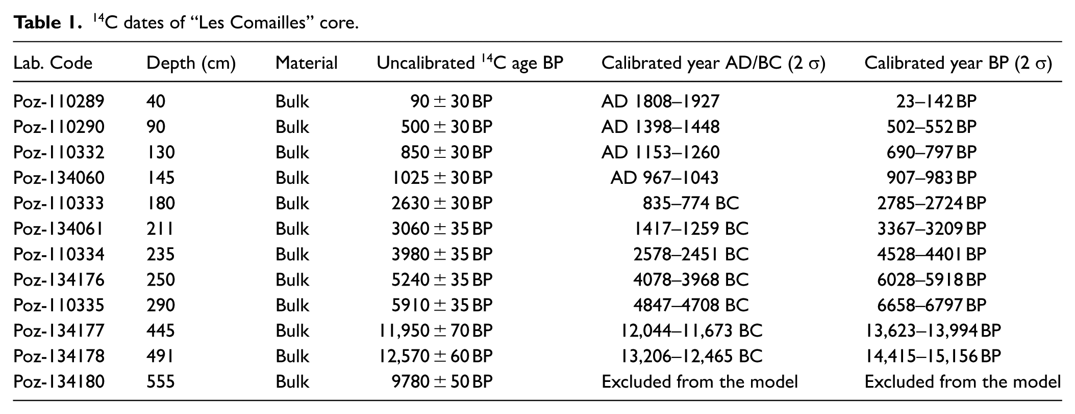
(a) age-depth model of the entire “Les Comailles” core (0–555 cm) with eleven 14C dates and (b) age-depth model of the studied “Les Comailles” core (0–235 cm) with seven 14C dates.
Sedimentation rate (cm yr−1), dry bulk density (g cm−3), water content (%H2O), LOI550 (%), C/N ratio, Ca and Ti by XrF measurements (cps), Ca/Ti ratio and lithology of the core (for lithology legends, see Figure 2).
Physico-chemical characterization of the core
The dry bulk density (g cm−3; Figure 3) was measured on freeze-dried samples in terms of water content (%H2O; Figure 3). This measure was realized by weighing samples before and after freeze-drying to obtain the water content.
Loss on ignition (LOI550; Figure 3), representing the organic matter content, was determined as follows: after drying at 105°C for 20 h, the samples were weighed and burned at 550°C for 4 h (Heiri et al., 2001).
Carbon (C) and nitrogen (N) contents (C/N; Figure 3) were determined by a VarioMAX CNS analyzer (Elementar) on freeze-dried and ground sub-samples. Two measurements were performed on the sample every 10 measurements to check the analyses.
X-ray fluorescence (XrF) core scanning was performed at EDYTEM laboratory (Université Savoie Mont-Blanc, UMR5204, Le Bourget du Lac, France) with an Avaatech XRF Technology core scanner (Rhodium source). A continuous 0.5 cm step measurement was applied with (i) a run at 10 kV and 1.2 mA for 10 s to detect calcium (Ca) and titanium (Ti), and (ii) a run at 30 kV and 0.2 mA for 10 s to detect copper (Cu), Fe, manganese (Mn), nickel (Ni), lead (Pb), rubidium (Rb) and zinc (Zn; Supplementary Data S1). The XrF core scanner results are expressed as peak intensities by counts per second but only ratios of interest are presented in Supplementary Data S1.
Geochemical analyses
Trace element concentrations by ICP-MS
According to previous XrF analyses of the core (Supplementary Data S1), 42 samples with a thickness of 1 cm were selected to characterize more precisely periods of TM emissions. Trace element (TE) analyses were conducted by the “Service d’Analyse des Roches et des Minéraux” (SARM; CRPG-CNRS, Nancy, France) after grinding of freeze-dried peat samples. Trace element concentrations were determined by an Inductively Coupled Plasma Mass Spectrometer (ICP-MS iCapQ Thermo). Samples were prepared and measured following the procedure of Carignan et al. (2001). Briefly, freeze-dried peat samples were mixed with LiBO2 and melted (alkaline fusion). The fusion products were further dissolved in diluted nitric acid before measurements. Analytical accuracy of the analyses was checked by using five certified reference materials (CRMs, n = 150 per CRM) that were routinely used for 6–12 months in the SARM (Supplementary Data S2). For further details, see the SARM website at https://sarm.cnrs.fr/index.html/.
Owing to its role as a major element, Fe could not be chosen to trace past Fe-mining activities in the Puisaye district. Several elements were used instead based on research conducted by Berranger et al. (2026) who analyzed a large number of archeological waste samples from several Fe-metallurgical sites in Puisaye, in particular ore fragments and slag pieces. Major composition of ore fragments is highly homogeneous from the Iron Age, throughout the Roman period, and into the Early Middle Ages, with an iron-oxide content (total Fe2O3) ranging from 65 to 95 wt %; the mineral characterization highlights the dominance of Hemathite and Goethite in ore fragments analyzed (Berranger et al., 2026). The concentrations of TMs could vary considerably between ore fragments, as for example median of Zn concentration is 109.58 µg g−1 with a maximum value of 348.13 µg g−1 and a minimum value of 15.54 µg g−1 (Supplementary Data S5).
According to the accuracy of the ICP-MS TM measurements in peat samples (Supplementary Data S2), to their presence in local ores, to their immobility in peat core, or to their use as lithogenic element for normalization (Forel et al., 2010; Guédron et al., 2016; Reimann and de Caritat, 2005), 13 elements were chosen: arsenic (As), cadmium (Cd), cobalt (Co), chromium (Cr), Cu, Ni, Pb, antimony (Sb), tin (Sn) and Zn, as elements linked to Fe-metallurgical activities (Berranger et al., 2026; Mariet et al., 2018b; Martínez Cortizas et al., 2016; Pontevedra-Pombal et al., 2013); lanthanum (La), Rb and zirconium (Zr), as lithogenic elements.
Calculation of accumulation rates and enrichment factors of TMs from ICP-MS measurements
Trace metal accumulation rates (ARs) were calculated according to the following equation (equation 1).
With
Enrichment factors (EFs) were calculated following equation (2) (Weiss et al., 1999).
where
Palynological analyses
Sampling was conducted every 2 cm from 50 to 224 cm-depth. Sub-samples (1 g fresh matter) were prepared using the standard method established by Fægri and Iversen (1989) after the addition of exotic pollen grains of Lycopodium to estimate pollen accumulation rates (Stockmarr, 1971). Sub-samples were filtered to 200 µm and then treated with HCl 10%, HF 40%, NaOH 10% and acetolysis. At least 1000 pollen grains were counted on each level at 400× magnification and identified using the standard identification keys of the Central European pollen flora (Beug, 2004; Fægri and Iversen, 1989; Moore et al., 1991; Punt, 1976; Punt et al., 1988; Punt and Clarke, 1980, 1981, 1984; Reille, 1992, 1995) and the reference collection of the Chrono-environnement Laboratory.
The calculation of the pollen diagram was performed using the program TILIA 1.5.12 (Grimm, 1991). The pollen sum was calculated from the arboreal and non-arboreal pollen count; local arboreal taxa, that is, Alnus and Betula, wetland plants, that is, Sparganium-type, Filipendula, Hydrocotyle vulgaris, Typha latifolia, Saxifraga hirculus-type, Saxifraga aizoides-type, Drosera, Hottonia palustris, Persicaria maculosa-type, Alisma-type, Potamogeton-type, Rumex aquaticus-type, and spores were excluded from the sum. The pollen accumulation rate (103 grains cm−2 yr−1) was calculated according to the wet bulk density of the sample, the Lycopodium counts and the sedimentation rate (Figure 3). Pollen data were divided into Pollen Assemblage Zones (PAZs) by constrained incremental sums of squares cluster analysis (CONISS) of the relative abundance of pollen taxa (Grimm, 1987).
Statistical analyses
Statistical analyses were performed using the R (version 4.0.3) statistical software (R Core Team, 2020).
Correlations between physico-chemical parameters and rarefaction analysis of palynological data
Correlations between several physico-chemical parameters like LOI550, water content, dry bulk density and Ti content as cps (measured by XrF), were made with Spearman correlation tests.
Pollen diversity was estimated by rarefaction analysis (Birks and Line, 1992) using the “vegan” R package (Oksanen et al., 2012). This method standardizes sample size and does not consider the abundance of different pollen types.
Compositional data analysis and hierarchical cluster analysis on trace element concentrations
Compositional data analysis and hierarchical cluster analysis were executed using the following R packages: devtools, tidyverse, ggbiplot, robCompositions, factoextra, NbClust.
Compositional data analysis is a statistical method adapted to closed data, which usually sum up to a constant (which is the case for almost all geochemical data). It compensates for problems related to the bias of the covariance structure of compositional data, which casts doubt, without appropriate transformation, on any multivariate statistics based on the correlation matrix (Filzmoser et al., 2009, 2018).
Here, the elemental composition of a sample is defined by a vector of D trace element concentrations
with
The transformed data were processed using the covariance biplot (Aitchison and Greenacre, 2002). Some properties of the compositional biplot must be mentioned to facilitate interpretation. First, unlike for traditional biplots (Gabriel, 1971), the rays formed by individual components cannot be interpreted. Only links between “arrowheads” of variables are meaningful; they approximate the standard deviations of the log-ratios of these variables, whereas the angle cosines between links estimates correlations between two log-ratios (van Den Boogart and Tolosana-Delgado, 2013). For example, when two links are orthogonal, there is no correlation between the two log-ratios, whereas when components lie on the same line, their log-ratios are either strongly positively (or negatively) correlated. Note that the importance of absolute concentration values is lost during this statistical analysis. Only ratios between components make sense, and individual components, taken separately, cannot be interpreted, like for the classical Gabriel’s biplot.
In order to highlight changes in geochemical composition of samples along time, hierarchical cluster analysis was performed on the results of the compositional data analysis.
Ward's hierarchical cluster analysis (Ward, 1963) with Euclidian linking-distances was applied to the first two principal component scores from the compositional data analysis. This method uses variance analysis to evaluate distances between clusters in order to minimize the sum of squares of any two clusters that can be formed at each agglomeration step (Lee et al., 2019).
Results
Lithology and chronology
The upper 500 cm of the core covered approximately the past 15000 years (Table 1, Figure 2a). The 14C date at 555 cm depth was excluded from the age-depth model owing to an age-reversal (Table 1, Figure 2a). The three oldest dates (at 445, 491, and 555 cm) were obtained from gray clay, which means they predate the formation of the peat bog and correspond to sedimentary deposits from the adjacent river. The age-reversal is certainly due to a reworking of these sediments before the beginning of peat bog formation. Nevertheless, no other age reversal is present in the age-depth model. According to 14C dates, and to cover the archeologically known period of local metallurgical activities, only the 50–230 cm-depth corresponding approximately from 4200 to 200 cal. BP (Figure 2b), were studied.
The lithology is composed of light fibrous Sphagnum peat from the bottom to 137 cm-depth, with low sedimentation rate comprised between 0.0019 and 0.08 cm yr−1 (Figure 2b). Then, the peat became more fibrous until the top of the core. Well-decomposed dark layers were observed at 167 and 173 cm-depth.
Core characteristics
The zone between 200 and 150 cm-depth (yellow zone, Figure 3) was defined according to fluctuations of high amplitude measured for the physico-chemical parameters, especially on LOI550.
Samples were moderately to highly organic, with LOI550 from 41% to 99% and of 82 ± 13% in mean (Figure 3). From 230 to 200 cm-depth, values fluctuated between 60% and 99%. A fluctuating zone was recorded between 200 and 150 cm depth with several peaks reaching, for highest values, 90%, and for lowest values, 41%. LOI550 was then relatively stable, higher than 80%, except between 72 and 70 cm-depth with values reaching 56%.
Ratio of C and N varied from 19 to 58 with a mean of 31 ± 8. C/N values comprised between 30 and 46 in the bottom of the core (230–204 cm-depth). An increase was then recorded, reaching 57 at 180 cm-depth, followed by a decrease to 25 at 168 cm-depth. From 167 to 51 cm-depth, C/N values were comprised between 19 and 31.
Ca/Ti ratio was low between 200 and 150 cm depth, reaching values under 5. The ratio was then comprised between 10 and 20 and decreased at 5 around 70 cm-depth before a large increase at 15–20 between 70 and 50 cm depth. This latest zone corresponded to a shift in Ca/Ti ratio, the lowest C/N and dry bulk density measured and the highest %H2O, corresponding to the beginning of the acrotelm (Figure 3, pink zone).
Water content of samples lightly increased from the bottom to the top of the studied core and comprised between 73% and 92% (Figure 3). Water content and LOI550 were positively correlated (p-value < 0.001, rho = 0.64) and negatively correlated to dry bulk density (respectively p-value < 0.001, rho = −0.93; p-value < 0.001, rho = −0.64). Titanium cps obtained by XrF (Supplementary Data S1) were positively correlated to dry bulk density (p-value < 0.001, rho = −0.71).
Palynological diagram: three major pollen assemblage zones
Three major Pollen Assemblage Zones (PAZs) and seven sub-zones were defined according to CONISS (Figure 4, Supplementary Data S3).
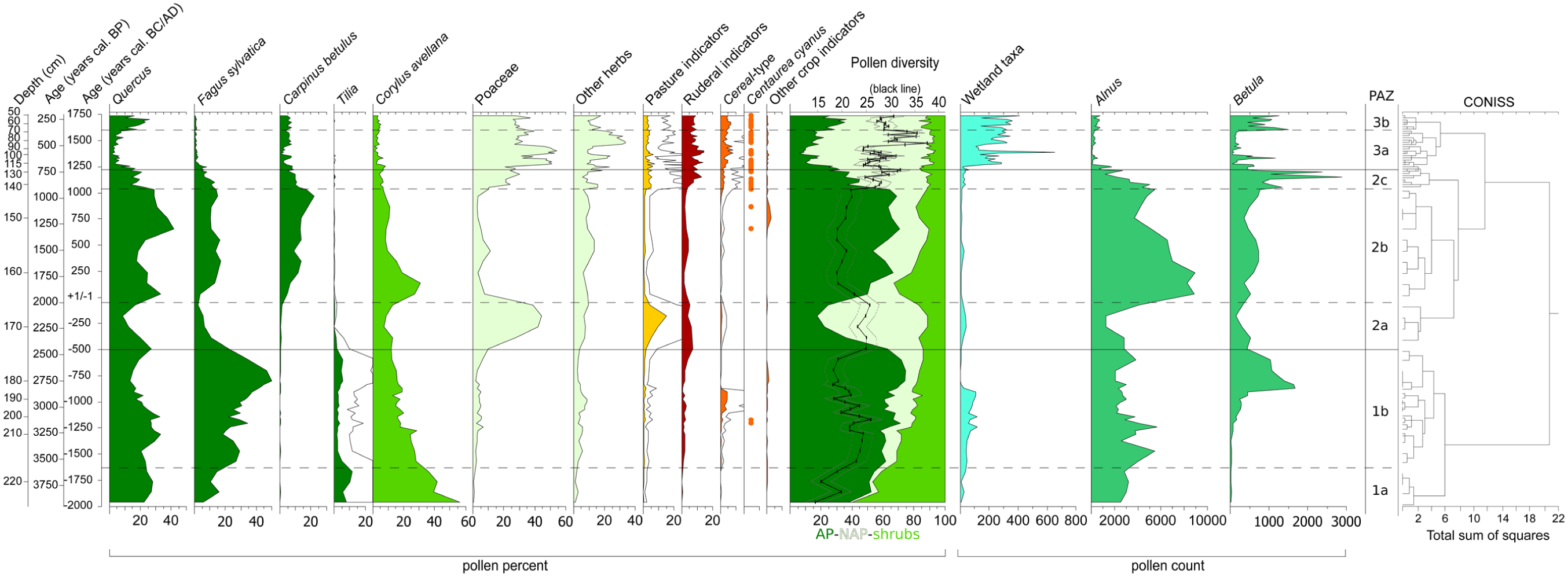
Simplified palynological diagram of “Les Comailles” core. Terrestrial taxa are represented in percentages, excluding Alnus and Betula represented in number of pollen grains as local taxa from the peat bog. Water plants, hygrophilous taxa and spores are excluded of percentages calculation and represented in number of pollen grains or spores counted. Empty curves represent exaggeration x5. “AP” means arboreal pollen, “NAP” means non-arboreal pollen percent. Pollen diversity (black line), expressed in number of species, was estimated by rarefaction analysis (dotted lines represent one standard deviation). Pollen Assemblage Zones (PAZs) were defined according to constrained incremental sums of squares cluster analysis (CONISS) on the complete diagram (available in Supplementary Data S3).
PAZ-1 was composed of two sub-zones.
PAZ-1a, from 2000 to 1625 cal. BC, had dominance of tree and shrub taxa, higher than 90% of the Total Land Pollen Sum (TLPS), with Quercus around 25%, Fagus increased up to 20%, Tilia, and Corylus avellana percentages decreased from 60% to 30%, as major taxa (Figure 4). Frangula alnus and Filipendula were present as indicators of megaphorb (Supplementary Data S3). Some crop indicators, with, for example, Cereal-type, and pasture indicators represented by heliophilous taxa, with, for example, Potentilla-type and Apiaceae (Supplementary Data S3), were present as well as ruderal taxa at lower percentages (Figure 4). Pollen diversity increased from 15 to 20 taxa on average.
PAZ-1b, from 1625 to approximately 500 cal. BC, was marked by a decrease of shrub taxa from 40% to 15% and an increase of tree taxa from 55% to 75% (Figures 4 and 6). Quercus decreased from 1250 cal. BC to 750 cal. BC while Fagus increased. Cereal-type peaked between 1100 and 800 cal. BC. Centaurea cyanus appeared around 1200 cal. BC. Pollen diversity varied with the mean value between 17 and 25 taxa.
PAZ-2 was composed of three sub-zones.
PAZ-2a, from 500 cal. BC to approximately the beginning of the Common era, was marked by a peak of Poaceae up to 45%, of ruderal taxa and pasture indicators, and a sharp decrease of all arboreal and shrub pollen taxa from 75% to 30% was noted (Figure 4). Quercus and Fagus decreased. Pollen diversity was stable around 23 taxa in mean (Figure 4).
PAZ-2b, from the beginning of our era to approximately cal. AD 1000 was characterized by the increase of arboreal and shrub taxa between 60% and 85% of the TLPS (Figure 4). Variations of arboreal pollen taxa were mainly due to those of Quercus which decreased at two times: between cal. AD 100–450 and cal. AD 700–1000. Nevertheless, Quercus was the dominant arboreal taxon of the zone comprising between 20% and 45%. After an initial increase, Fagus was relatively stable along this PAZ, around 10%–15% of representation while Carpinus increased from less than 5% to 20%. Tilia disappeared (Figure 4). Corylus reached a peak at 30% at cal. AD 100 and then continuously decreased. The sharp decrease of Poaceae, ruderal and pasture indicators is synchronous with the decrease of pollen diversity from 25 to 18 taxa in mean. Centaurea cyanus reappeared around cal. AD 600 (Figure 4).
PAZ-2c, from cal. AD 1000–1250, was marked by a rapid decrease of arboreal taxa down to 20% due to decrease of Quercus, Fagus and Carpinus (Figure 4). Poaceae, crop indicators, ruderal and heliophilous taxa together with other herbs, increased, while shrub taxa were stable (Figure 4, Supplementary Data S3). Centaurea cyanus was continuously present. The pollen diversity mean increased to 30 taxa.
PAZ-3 was composed of two sub-zones.
PAZ-3a, from cal. AD 1250–1600, was characterized by a decrease of arboreal taxa to 15% while Poaceae increased up to 45% (Figure 4). Fagus decreased to reach its lowest representation at 1%. Ruderal and pasture indicators were stable compared to PAZ-2c while Cereal-type slightly increased. Wetland taxa, in number of pollen counts, drastically increased while Betula and Alnus decreased (Figure 4). Picea abies appeared for the first time around cal. AD 1500 (Supplementary Data S3). Hydrocotyle vulgaris became dominant for wetland taxa, Cyperaceae and trilete spores were at their highest count levels and Drosera appeared (Supplementary Data S3). Pollen diversity continued to increase and reached the highest mean value of the studied core at 37 taxa.
PAZ-3b, from cal. AD 1600 to 1740, was marked by the increase of arboreal taxa as a result of the increase of Quercus from 5% to 25% (Figure 4). Poaceae decreased to 20%. Centaurea cyanus and Centaurea jacea-type (Supplementary Data S3) were observed in each sample. Pollen diversity decreased around 30 taxa at the end of the PAZ.
Geochemical data
Trace element concentrations by ICP-MS, ARs and EFs
Trace metal concentrations obtained by ICP-MS (Supplementary Data S4) varied from 1.16 to 84.91 µg g−1 for As, 0.06–0.64 µg g−1 for Cd, 4.33 to 48.61 µg g−1 for Co, 7.41 to 58.85 µg g−1 for Cr, 8.85 to 69.40 µg g−1 for Cu, 10.43 to 103.97 µg g−1 for Ni, 3.24 to 61.46 µg g−1 for Pb, 0.06–0.48 µg g−1 for Sb, 0.31 to 2.04 µg g−1 for Sn (two concentrations were lower than LoD, see Supplementary Data S2) and 13.40 to 572.11 µg g−1 for Zn. Concentrations of lithogenic elements (Supplementary Data S4) varied from 1.39 to 90.22 µg g−1 for La, 2.46 to 59.40 µg g−1 for Rb and 5.38 to 111.41 µg g−1 for Zr.
The ARs of the 10 TMs analyzed had similar pattern along the core. Six of them were chosen according to their importance in local ores and slag pieces (Supplementary Data S5) and to their high fluctuations along the core: As, Co, Ni, Sn, Zn (Figure 5) and Pb (Figure 6).
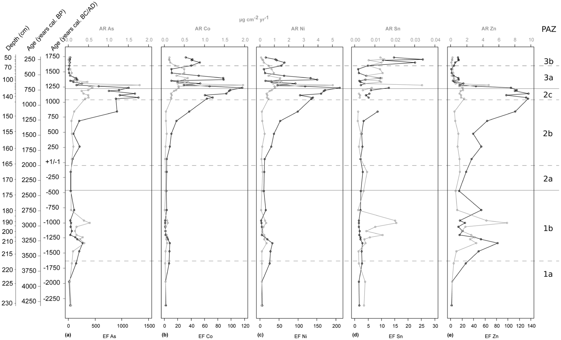
Accumulation rates (ARs, gray lines, µg cm-2 yr−1) and enrichment factors (EFs, black lines) of (a) As, (b) Co, (c) Ni, (d) Sn, and (e) Zn (data from ICP-MS analyses). Pollen assemblage zones (PAZs) were reported from Figure 4.
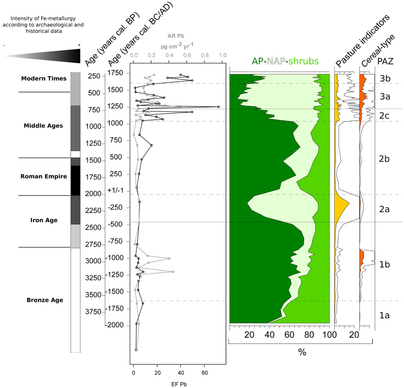
Iron-metallurgy intensity according to historical and archeological knowledge versus main paleoenvironmental proxies along the core (accumulation rates of Pb in gray, AR Pb in µg cm-2 yr−1; enrichment factors of Pb in black, EF Pb; arboreal pollen percent (AP); non-arboreal pollen percent (NAP); shrub percent; pasture indicators and Cereal-type percents). Pollen assemblage zones (PAZs) were reported from Figure 4.
Two peaks of ARs of, approximately the same intensity (except for Co), were recorded: first, between 1290 cal. BC and 750 cal. BC and, second, between cal. AD 1060 and 1360 (Figure 5). The ARs for Pb were the lowest of the four chosen TMs, ranging from 0.007 to 0.55 µgcm2 yr−1 (Figure 6). The ARs for As and Co were in the same range between 0.01 and 1.96 µg cm−2 yr−1 (Figure 5a and Figure 5b) whereas those of Zn were the highest, ranging from 0.08 to 7 µgcm2 yr−1 (Figure 5e).
As the three lithogenic elements analyzed showed the same pattern along the core, Rb was chosen as conservative element for calculation of EFs according to the recommendations of Reimann and de Caritat (2005) and particularly to its low concentration range compared to La and Zr (Supplementary Data S4). Enrichment factors of TMs showed two increases, reaching peaks synchronously to those of ARs (Figure 5). A noticeable difference was an earliest increase of EFs compared to ARs: the first increase began around 1620 cal. BC and the second one around 120 cal. BC. Pb EFs were the lowest, reaching 71 during the rapid increase dated from cal. AD 700–1250 (Figure 6), those of Co and Zn were in the same range, reaching respectively 116 and 135 during the same peak (Figure 5b and Figure 5e), whereas those of As were the highest, reaching 1249 (Figure 5a).
Compositional data analysis and clustering of geochemical data obtained by ICP-MS
The first two components of the biplot explained 74.6% of the total variance, a fair value for 13 variables (Figure 7a). Pb, Sn and Sb, on the one hand, and Cu, Co, and Ni, on the other hand, plot relatively close to each other (i.e. their links are short), indicating relatively constant log-ratios among the variables that compose these groups. Cadmium lies apart. Arsenic and Zn log-ratios were negatively correlated with that of Pb.
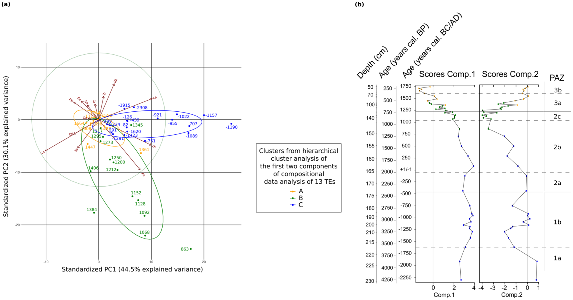
(a) Covariance biplot of compositional data analysis. Numbers represent the calibrated years BC/AD of the samples along the core, capital letters (A, B, C) represent the clusters from hierarchical cluster analysis of the scores of the first two components of compositional data analysis (the cluster distribution ellipse represents one standard deviation) and (b) scores of the first two components of the compositional data analysis along the core. Samples were divided in three clusters (A, B, C) according to hierarchical cluster analysis on the scores.
The hierarchical cluster analysis made on the scores of the first two components of compositional data analysis (Figure 7b) highlighted compositional changes over time (in terms of elemental ratios). The oldest samples, from 2308 cal. BC to cal. AD 707 (cluster C, Figure 7b) plot in the right of the biplot (Figure 7a). Those from cal. AD 707–1406 (cluster B, Figure 7b), in the bottom of the diagram (Figure 7a). The most recent samples form a group in the center of the biplot (cluster A, Figure 7b). Only one sample, cal. AD 1361, did not fit the chronological pattern of the clusters (Figure 7b).
Discussion
Global evolution of the peat bog along time
The lower dry bulk densities measured in the top of the core demonstrate the undisturbed character of the peat at the coring point (Martínez-Cortizas et al., 1997).
The Ca/Ti ratio combined with C/N ratio and LOI550 show a transition between the minerotrophic part of the bog, from the bottom to 150 cm depth, to the ombrotrophic part, from 150 cm-depth until the top of the core (Kuhry and Vitt, 1996; Shotyk, 1996). Highest C/N values in the lower half bottom of the core are related to several shifts in lithology that present layers of light fibrous peat in alternation with highly decomposed peat. It is also related to the presence of layers with low organic matter content, as shown by LOI550 reaching 40% at several measurement points between 200 and 150 cm-depth and by peaks of Ti content related to allochthonous mineral supply. The location of the Comailles site in an alluvial plain is certainly the cause of these detrital inputs, as pollen of wetland taxa have been identified throughout the entire sequence (Supplementary Data S3). However, no anomaly of TM content has been recorded in these depths, demonstrating the reliability of the core to trace past anthropogenic emissions of TMs. Moreover, these detrital inputs have been corrected by the calculation of EFs for TM record.
During the whole period, the landscape surrounding the peat bog comprised moist forests similar to that currently observed with Betula and Alnus as the dominant arboreal taxa, being more or less abundant according to the period, with Filipendula, as dominant megaphorb, and Vitis, attributed to the wild vine as it is still found today in this alluvial forest (Supplementary Data S3). The establishment of Betula during the Late Bronze Age, since approximately 1300 cal. BC, can be linked to drier conditions of the peat bog, shown by higher dry bulk density and the decrease of wetland taxa.
Bronze Age: an increasing anthropogenic impact on the landscape
Early Bronze Age: 2000-1600 cal. BC
During the Early Bronze Age, tree cover was dense, with deciduous forest in the drier areas dominated by Quercus, Fagus, and Tilia as main arboreal taxa and Corylus possibly in coppice, as also recorded by Jouffroy-Bapicot et al. (2007, 2013) from several peat bogs in the Morvan, approximately 50 km south-east of Puisaye. Moreover, at the European scale, this period corresponds to the subboreal, a phase characterized by mixed forest of Quercus and Fagus for the West of Europe (Magny et al., 2002).
In the absence of metallurgical sites dated from the Early Bronze Age in Puisaye, it makes it difficult to attribute the slight increase of TM emissions, in particular for As and Zn, recorded in the peat bog to bronze metallurgy.
Middle Bronze Age: 1600-1400 cal. BC
Archeological investigations from the Burgundy region have revealed the presence of numerous sites dated to this period, containing large deposits of tools, weapons and ornaments (Gabillot et al., 2015). However, no finds have been made in the Puisaye region, with the nearest sites being in the Yonne valley some 30 km to the east. The increase of Co, Ni, Zn ARs and EFs recorded in the peat core may be linked to bronze metallurgy. To explain this increase, we could hypothesize a long-distance input of TMs, as prehistoric mining activities have been attested in the Morvan since the beginning of the Middle Bronze Age, and more widely across Europe for this period (Longman et al., 2018). Nevertheless, even if Cu-metallurgical activities are attested in Europe earlier, they are scarce, spatially dispersed and consist of small and mobile workshops that make it difficult to link with TM emissions or changes in vegetation cover with any degree of certainty.
For this period, the slight decrease of Fagus and Quercus could be related to the first significant forest clearance for crop activities related to local settlements in Puisaye.
Late Bronze Age: 1400-800 cal. BC
At the Western European scale, the Bronze Age represents a major step in the landscape history, with global opening of woodland and the establishment of perennial fields (Iglesias et al., 2019). This is confirmed in Puisaye, where an increasing human pressure on the landscape was recorded, reflected by Cereal-type and Centaurea cyanus, considered as an indicator of local crop cultivation (Brun, 2011; Brun et al., 2007). Forests are moderately affected, especially in composition: Fagus is in expansion to the detriment of Quercus, related to the cutting of Quercus for use as timber in construction and/or fuel, leading to higher pollination of Fagus as a result of a decrease in competition. These changes are consistent with those recorded by several peat bogs in the entire Morvan by Jouffroy-Bapicot et al. (2007, 2013), demonstrating an increase in anthropogenic activities at a regional scale. However, the interpretation must be treated with caution owing to higher sampling resolution for this period than previous one.
The continuous decrease of the light-demanding species Corylus throughout the Bronze Age could be due to the closure of the forest cover, as indicated by the increase of Fagus, and/or the destruction of hedges, where Corylus is common. This process could be initiated to obtain wood of small diameter for combustion: indeed, Jakobitsch et al. (2022) highlighted the preferential use of thinner branches of Fagus as fuel during this time period.
Synchronous landscape changes and evidences of atmospheric emissions of TMs linked to bronze manufacture, suggest the presence of punctuated Cu-metallurgical activities with very local impacts in Puisaye. This proposition is reinforced by the geochemical study of three different peat deposits in the Morvan, where TM emissions from the Bronze Age seemed perceptible in some, but not all instances (Jouffroy-Bapicot et al., 2007). However, a long-range transport of TM atmospherically emitted from the Morvan to the Puisaye could not be excluded, as probable Cu-Ag metallurgical activities have been highlighted by Jouffroy-Bapicot et al. (2007, 2013) for this period.
Iron Age: the beginning of attested local Fe-metallurgy in Puisaye
First Iron Age – Hallstatt: 850-450 cal. BC
First archeological evidences of Fe-metallurgy in Puisaye came from a few discrete slag heaps dated between 800 and 500 cal. BC (Berranger et al., 2023). Their limited size and relative scarcity suggest a consistent relationship with the low levels of TMs recorded. In the vicinity of the Comailles peat bog, crop indicators are at lower levels than during the Bronze Age, which could be linked to unfavorable climatic conditions of this period (Magny et al., 2009), limiting crop cultivation in the valley of the Branlin. The increase of ruderal taxa also supports the assumption of a shift in main anthropogenic activities from crop cultivation to pastoralism.
The composition of the mixed deciduous forests changed significantly during this period. Fagus reaches its maximum representation at the beginning of the Iron Age, possibly favored by the previous cutting of oak trees during the Late Bronze Age, although climatic deterioration may have played a role in this interspecific competition; on that note, it should be stated that beech is currently very rare, if not absent from these mixed forests. Fagus begins a major decrease around 700 cal. BC, in a motion that could be linked to wood exploitation dedicated to mining and metallurgical activities, as they are archeologically known in the Puisaye for this time period. This scenario is supported by the “principle of least effort” mentioned by Jakobitsch et al. (2022) for wood collection in the vicinity of Cu-mining area in the Eastern Alps for the Late Bronze Age, where it seems that there was no preferential selection of wood but cuttings followed the availability of species with sufficient branch diameters surrounding the mining areas. However, we cannot exclude the role of other anthropogenic activities in vegetation changes recorded in Puisaye.
Second Iron Age – La Tène: 450-50 cal. BC
During this time period, Fe-bloomery workshops are more spatially grouped than before, the volume of production seems to increase. Numerous changes in smelting processes have also been noted, namely changes in the architecture of furnaces and the typology of the slag (Berranger et al., 2023, 2026). However, low TM emissions are recorded compared to previous periods, possibly because of larger distance between smelting sites and the Comailles peat bog, although it could be linked to aforementioned changes in production methods. While contaminations are low, the landscape undergoes significant changes. The sharp decrease of all arboreal taxa recorded in the Comailles core is synchronous to those described throughout 10 sequences from the north to the south of the Morvan, where a strong anthropogenic impact was observed with systematic increase in woodland openness (Jouffroy-Bapicot et al., 2013). This process could still partially result from the fuel demand of metallurgical activities, although it appears mostly explained by the conversion of forest into grasslands, through the establishment of local crop cultivations and pastoral activities, leading to increased pollen diversity.
In Europe, several paleoenvironmental studies near prehistoric mining sites suggest that the impact of these activities is negligible and only marked by changes in forest composition (Breitenlechner et al., 2010; Mighall et al., 2017) and/or local deforestation followed by rapid forest recovery (Mighall et al., 2000, 2002). In that respect, the present paleoenvironmental dataset alone cannot justify to link with certainty metallurgy and deforestation in the prehistoric Puisaye district. However, the exploitation of its woodland resources has been shown to have served as an asset to local economic development, which has in turn led to significant changes in forest composition and expanse.
Roman Empire: the apogee of Fe-metallurgy based on bloomery furnace
High Roman Empire: 50 cal. BC to cal. AD 200
In Puisaye, the high number of smelting sites dated to this period allows identifying a large intensification of Fe-metallurgical activity that could be qualified as a first pre-industrial development (Berranger et al., 2023). This district, which could be extended north to include the Pays d’Othe, south to include the Nivernais and Vézelinen, and west to include the Biturige territory, constitute one of the major production area for this period (Berranger et al., 2023).
However, the increase of EF is notable only for Zn, and remains minimal for other TMs. The limited number of samples geochemically analyzed for TMs by ICP-MS (only two samples) could explain these measurements, as a peak in element ratios is measured by XrF analyses (10 samples taken into account) for the end of the same time period, confirming the increase of metallurgy intensity (Supplementary Data S1). In addition, the bloomery furnace technology, which emitted fewer contaminated particles than later blast furnaces, could have led to a signal lower than expected, as highlighted by other paleoenvironmental studies (Bindler et al., 2011; Karlsson et al., 2016). Lastly, an increased distance between Fe-smelting sites and the Comailles peat bog could also have led to the dilution of the geochemical signal.
After sharp forest clearances and development of pastoralism during the Second Iron Age, the palynological diagram shows a natural dynamic of vegetation recovery, the establishment of secondary forests with the appearance of Carpinus, and the recovery of Corylus in the vicinity of the Comailles peat bog. Only one arboreal taxon, Quercus, was affected adversely by anthropogenic activities, although to a lower extent than during the Iron Age. Moreover, anthropogenic pressure on local vegetation appears limited, as crops and pasture indicators decrease. This development, bringing together an intense metallurgical activity and a definite forest recovery while these two parameters seemed opposed for earlier periods, could be explained by an intent to preserve forests, possibly through legal decisions aimed at ensuring the sustainability of wood resources dedicated to metallurgical activities (Nouvel, 2016). Indeed, Fe-metallurgy seems to constitute one of the main economic activities developed in Puisaye during the High Roman Empire. However, a more thorough hypothesis, as proposed by Nouvel (2016) for the Pays d’Othe, drawing a spatial partition between smelting sites and rural exploitations, is difficult to discuss in Puisaye. The current extensive forest cover is an obstacle for the identification of archeological sites other than smelting sites. Consequently, the available data are still insufficient to study the organization of settlements in Puisaye.
An anthracological study was conducted on material from two excavated slag heaps dated to the High Roman Empire (Montholon, northern Puisaye district: sites one and nine; Girardclos and Jeannot, 2019). The observation of charcoal assemblies highlighted a relative dominance of Quercus (42%—70%) over Fagus (18%—46%) thus confirming that the palynological decrease of Quercus was due to its selective exploitation as fuel, supported to a lesser degree only by Fagus and Carpinus at 2.4%. This spectrum is completed with pioneer Populus at 5.4% maximum, Salix, and some post-pioneer species, Maloideae and Acer. This study also demonstrated the predominant use of small-caliber oak wood, characterized by growth dynamics more compatible with dense coppice forest structure than open forest. Such a structure being primarily observable in extensive forested areas, these observations tend to suggest the management of possible farming-exclusion zones, emphasizing an intent to preserve forests already stated.
Late Roman Empire: cal. AD 200-500
Fe-metallurgy continues to develop in Puisaye into the Late Roman Empire, with numerous slag heaps dated to this period (Berranger et al., 2023). This intense phase of Fe-metallurgical activities is well recorded in the Comailles core by the increase in the 6 TM EFs, while tree cover remains important, with a minimum of 70% of arboreal pollen. In contrast, a study of contemporaneous Pyrenean charcoal kilns conducted by Pèlachs et al. (2009) highlighted a very localized but intense impact of charcoal production for Fe-smelting on exploited forests. Just as for the previous period, the lack of deforestation signals recorded by the Comailles peat bog during the Late Roman Empire could be explained by several hypotheses: it could be due to (i) the long distance from charcoal production sites to this archive, (ii) the presence of farming exclusion areas in its vicinity, or (iii) a forest structure that presents large areas repopulated in coppice after Iron Age clearings, leading to some species being over-represented in the record. This last hypothesis is supported by the results of Etienne et al. (2013) who demonstrated, by the study of pollen rainfall along a transect in a forest in coppice with standards, that species composing the coppice layer, such as Carpinus, were over-represented in the pollen rainfall compared to species of the tree layer, such as Quercus.
As shown above, wood cutting appears mainly focused on Quercus in Puisaye, while in the north of the Morvan for the same period, Jouffroy-Bapicot et al. (2013) showed wood cutting preferentially focused on Fagus. This difference of exploited species is probably due to the respective dominance of one and the other in each region. Indeed, Fagus in Puisaye was at 20% of TLPS while Quercus reached 35% of TLPS in the palynological diagram before Roman forest exploitation. In the north Morvan, Quercus was at 10% of TLPS while Fagus reached 40% of TLPS before a deeply transformative exploitation. As shown for previous periods, it may indicate that Quercus, Fagus and Carpinus, were preferentially selected compared to the others during the Late Roman Empire, as Corylus is underrepresented in anthracological studies of slag heaps.
From cal. AD 400 onward, tree cover increases with the recovery of Quercus, but without change in pollen diversity owing to the diversification of ruderal taxa. Anthropogenic pressure on vegetation is high but probably less from metallurgy. Indeed, only one slag heap is dated between the fifth and the sixth centuries in Puisaye, revealing a clear change in the organization of Fe production. In the Comailles core, only one sample was geochemically analyzed by ICP-MS for TMs for this timespan; ARs and EFs therefore cannot be interpreted. However, element ratios from XrF analyses decreased for each TM after the peak of emissions recorded during the end of the second and the fourth centuries (Supplementary Data S1). The quasi-hiatus in archeological data in the fifth and sixth centuries (Figure 6) is thus more probably related to a significant decrease in Fe-metallurgy rather than a research bias.
Middle Ages: a spatial extension of Fe-metallurgy at a regional scale
Early Middle Ages: cal. AD 500-1000
Local crop cultivation appears following the recovery of the oak-beech-hornbeam forest, as indicated by the slight increase of Cereal-type pollen and the very local messicole species, Centaurea cyanus (Brun et al., 2007). A change in the organization of Fe production is highlighted by archeological surveys, which show smaller but more homogeneously distributed sites across the wider region (Berranger et al., 2023; Nouvel, 2016). Parallel to the multiplication of metallurgical sites, a high signal of TM atmospheric emissions is recorded with the sharp increase of As, Co, Ni, Sn and Zn EFs; compared to another Fe-smelting district in the Vosges Mountains (Mariet et al., 2018b), ARs of As are approximately 16-fold higher in the Comailles core for the same time period.
From cal. AD 800 to the turn of the millenium, the increasing representation of shrub taxa suggests the cutting of the tallest trees and the dominance of coppice. Archeological data show a new multiplication of smaller slag heaps in the Puisaye district that could be put forward as a reason for the increase of pressure on vegetation showed for the period. Crop and pasture indicators remain at low level, suggesting once more a spatial partition between metallurgy and other anthropogenic activities.
Late Middle Ages: cal. AD 1000-1500
The landscape around the Comailles peat bog largely opens from cal. AD 1000 onward, with continuous clearing of all tree and shrub taxa, as documented on a Europe-wide scale for the Middle Ages (Roberts et al., 2018). An anthracological study conducted on a slag heap dated to cal. AD 1000–1200 (Montholon, northern Puisaye district: site 10; Girardclos and Jeannot, 2019), showed charcoal spectra dominated by Fagus, at 80%—94%, and to a lower extent by Quercus and Carpinus, between 5 and 19% cumulated for both. These findings reflect perfectly the decrease of the three taxa recorded in the Comailles core, and thus support the importance of metallurgy in these transformations. Corylus presents dynamics that seem unrelated to these phenomena, with its pollen representation decreasing while being absent from charcoal assemblies. Such a contrast could, however, be explained either by its selection for other uses (such as domestic or ceramic fuel, woodcraft, etc.) or by pollinating trees being in areas outside forests exploited for metallurgical purposes.
Compositional data analysis highlights a change in the geochemical composition of peat samples at the beginning of the Late Middle Ages with As and Zn becoming the major TMs of samples. A peak of Co, Ni and Pb ARs and EFs is also noted. Berranger et al. (2026) showed no clear differences of TM composition of slag from the Middle Ages compared to those of the Roman period. However, slag typomorphology showed changes in smelting processes between these two periods with the appearance of a new and distinct slag type. These changes could have led to changes in the geochemical composition of emissions from bloomery furnaces. Moreover, the emission of TMs in higher quantities until cal. AD 1250, reaching the highest EFs recorded for the six TMs, could also be linked to these smelting process changes rather than to a metallurgy intensification, the latter not being documented archeologically (Berranger et al., 2026). After cal. AD 1250, TM emissions decreased and the sample dated from the mid-14th century shows a different geochemical composition. This event might be related to the Black Plague that led to successive famines and a sharp decrease of population, and consequently to a decrease in metallurgical activities. At the same time, pollen diversity increases, related to the diversification of crop indicators, ruderal taxa, and pasture indicators, while the total representation of these taxa is stable. These observations could indicate a diversification of agro-pastoral activities and the displacement of metallurgical production away from the Comailles site.
Modern Times: cal. AD 1500-1740
The transition to the Modern Times is marked by a new shift in geochemical composition of the samples. The transition from bloomery furnaces to blast furnaces, around the 14th–15th centuries, could have led to this shift. The modification of the smelting process also allows to treat larger quantities of ores. However, emissions of TMs still decrease for As and Zn while they are more fluctuant for Co, Ni, Sn and Pb. Iron-metallurgy in Puisaye during the Modern Times is archeologically not well known and mainly documented by historical archives (Bully in Berranger et al., 2019). We could hypothesize that, even if the production of Fe is equivalent to those of Middle Ages, the number of sites is reduced and they are located far from the Comailles wetland, inducing low TM emission record. In the absence of data on isotopic composition of local ores, and because of the ability of the Comailles peat bog to record a regional signal of anthropogenic activities, it is not possible to discriminate Fe-metallurgy from other sources of TMs which are globally increasing during the Modern Times. Indeed, the recent increase of Pb (Figure 6) is related to the beginning of the Industrial Revolution, a phenomenon well documented in Europe (Allan et al., 2013; De Vleeschouwer et al., 2009; Longman et al., 2018; Mariet et al., 2016).
During this period, a forest dominated by Quercus recovers from cal. AD 1600, while Fagus has disappeared in the vicinity of the peat bog and Carpinus and Corylus have low pollen representation. A law by Colbert for forest management in 1669 favored the forestry of Quercus, to the detriment of other species, for navy yards and cooperage. Around the Comailles peat bog, there were no large rivers for wood exportation by floating; the management of forests for the production of tall Quercus trees was therefore most probably intended for cooperage. The most recent samples of the palynological diagram show a landscape similar to those described by Leguédois et al. (2011; see Figure 1b) for the local current potential arboreal vegetation, dominated by Quercus sp. at 86% of surface and Carpinus betulus at 2% surface. The vicinity of the peat bog is fully devoted to agro-pastoral activities, with open meadows and crop cultivations, evidenced by the continuous presence of Centaurea cyanus.
Conclusion
Despite the minerotrophic status of the bog until 150 cm depth, the Comailles peat bog showed its ability to trace TM emissions since the Early Bronze Age. Located in the ancient smelting area of Puisaye, the peat bog has recorded significant local Fe-metallurgy since the First Iron Age to Modern Times. First significant geochemical record of TM emissions in the core is dated from the Late Bronze Age and may be related to punctuated Cu-metallurgy, even if no archaeometallurgical workshop is known for this period in Puisaye. However, our study highlights that, even with an environmental archive at the heart of the mining district, prehistoric metallurgy is difficult to trace using paleogeochemistry alone and need the use of several proxies. The beginning of intensive Fe-metallurgy is dated back from the Second Iron Age and coincides with major forest clearances, evidenced by palynological analyses. Changes in smelting processes and organization of production at the scale of the region are consistently linked to changes in the geochemical composition of atmospheric emissions, according to the compositional data analysis. It suggests the potential ability of peat bog to record changes of smelting processes through time.
The palynological study of the Comailles core shows changes of tree cover during phases of metallurgy, while the forest remained dominated over time by Quercus or Fagus, two taxa known to be favorable for combustion. Comparison of palynological and anthracological data from slag heaps highlights the selection of wood intended for metallurgy, with preferential cutting of these favorable taxa over other trees or shrubs that appear underrepresented in charcoal spectra, such as Corylus. The study also shows that the continuous presence of Fe-metallurgy in Puisaye over an extended period implied the implementation of a sustainable wood-production system. This seems to have been made possible by specializations in land use, by a forest structure dominated by coppice, and possibly by the existence of farming exclusion. Moreover, the study of the Comailles peat bog demonstrated major changes in the local ecosystem, fully devoted either to wood production during phases of intense metallurgical activity or to agro-pastoral activities in other periods. Although metallurgy and agro-pastoral activities were intrinsically linked throughout all periods of metallurgical activity, no clear increase of agro-pastoral indicators has been highlighted during periods of intense metallurgy, leading us to hypothesize that there was a spatial separation between metallurgy and crop activities in Puisaye.
The questions of the spatial exploitation of forests over time and of the turnover of farming exclusion areas need further investigation through paleoenvironmental analyses of other wetlands in Puisaye and archeological surveys. For this last aspect, the study of extensive LiDAR acquisition could allow identifying more Roman rural settlements under forest cover.
Supplemental Material
sj-docx-1-hol-10.1177_09596836261458234 – Supplemental material for 4000 years of trace metal record in a former iron-smelting district, West Bourgogne (France): multi-proxy paleoenvironmental assessment of human impacts on the landscape
Supplemental material, sj-docx-1-hol-10.1177_09596836261458234 for 4000 years of trace metal record in a former iron-smelting district, West Bourgogne (France): multi-proxy paleoenvironmental assessment of human impacts on the landscape by Anne-Lise Mariet, Carole Bégeot, Isabelle Jouffroy-Bapicot, Marion Berranger, Olivier Girardclos, Rémy Jeannot, Stéphane Venault and Frédéric Gimbert in The Holocene
Footnotes
Acknowledgements
We thank Marc Leroy, Sylvie Laurent and Jean-Pierre Piétak for their implication in the SIDEROS project, Victoria Vienot-Cartier, Julien Didier, Fanny Canone and Christophe Loup for their help during field and lab work. The authors thank the PEA2t Platform (Université Marie et Louis Pasteur, CNRS, UMR 6249 Chrono-environnement, F-25000 Besançon, France), which manages and maintains the analytical equipment used in this study. We thank the reviewers for their comments, which help to greatly improve the manuscript.
ORCID iDs
Author contributions
Funding
The authors disclosed receipt of the following financial support for the research, authorship, and/or publication of this article: This work was supported by a grant from the Conseil Régional de Franche-Comté (SIDEROS project, coord. Frédéric Gimbert).
Declaration of conflicting interests
The authors declared no potential conflicts of interest with respect to the research, authorship, and/or publication of this article.
Data availability statement
The data will be shared if requested.
Supplemental material
Supplemental material for this article is available online.
References
Supplementary Material
Please find the following supplemental material available below.
For Open Access articles published under a Creative Commons License, all supplemental material carries the same license as the article it is associated with.
For non-Open Access articles published, all supplemental material carries a non-exclusive license, and permission requests for re-use of supplemental material or any part of supplemental material shall be sent directly to the copyright owner as specified in the copyright notice associated with the article.