
Abstract
This article concerns the birth and death of the proposed Survey Law of 1874 in the South African Republic (Transvaal), a law that promised to ‘correct’ flawed or fraudulent knowledge with an ongoing triangulation and a general survey of lands that would locate and map all aspects of geography for the state. Such knowledge was essential to the rising class of technocrats that had taken over government bureaus in Pretoria in 1872 and who sought to stabilise and then grow the finances of the republic to support the modernisation of its administration of land as well as its other functions. To this end, a network of technical consultants with knowledge across the subcontinent—and occasionally beyond—worked to draft a law and make the case. Despite the manifest failings of existing systems of land inspection and wide agreement on the desirability of a detailed survey in governmental and scientific circles, however, other forces opposed a formal survey of lands on grounds of cost, principle and possibly self-interest. The result was a failure to pass the draft law or even consider its technical merits. This failure speaks strongly to the need to consider the political and social contexts and conflicts around technical networks and discourses as being relevant to their operation and their outcomes.
From the late 1830s until 1877, and then again from 1881 until the South African War of 1899–1902, the Transvaal region between the Vaal and Limpopo Rivers was under the notional authority of the South African Republic (ZAR). This ZAR was a settler state built around the patriarchal authority of mostly Dutch-speaking agrarian settlers known over time as Boers (literally farmers).These Boers had left the British-controlled colony of the Cape of Good Hope over a variety of grievances, most of which intersected with the right to the land and government power in some way. Although they formally surrendered institutional slavery as part of British recognition of their autonomy in 1852, the ideals of free land and weak government remained unchanged. In the Transvaal, the resulting infighting and splintering meant that a unitary ZAR only really emerged after 1864. Even then, independent African polities, settler constituencies and neighbouring colonies all placed powerful limits on the reach of the government in the capital of Pretoria. The assertion of exclusive power over the land was an essential step in the construction of this settler state as a meaningful and modern entity, but efforts to define that state territorially pitted networks of technical experts and modernisers against popular agrarian ideals and visions of settler landscapes within this republic of volitional migrants (Veracini, 2021, pp. 1–9). This conflict is visible in the abortive and forgotten efforts to create usable spatial knowledge—a geographical archive of the state, to borrow from Edney (1997)—during the presidency of Thomas François Burgers (1834–1881) between 1872 and 1877.
This article concerns the birth and death of the Survey Law of 1874 in the ZAR, a law that promised to ‘correct’ the distorted geographies of the Transvaal through the ongoing labours of a network of surveyors and their sympathetic allies both on the scale of individual properties and more broadly in an ongoing trigonometrical survey to locate and map all aspects of geography in the republic. These distortions of position and extent created occasional problems for the mental geographies of rural Boers, but they were wholly invisible for Africans except when those incongruities became visible and generated conflict. Geographical uncertainty, however, created other economic and political problems for the small coterie of technocratic officials within the ZAR government who dealt with the problems that uncertain geographical positions and insecure land titles created. Starting in 1873, they began to pursue a general survey of lands and some sort of corrective triangulation with the aid of like-minded compatriots outside the republic. These initial efforts, however, failed to create legal or practical institutions, but even in failure, they established personal networks and principles that informed future efforts in the Transvaal and elsewhere on the subcontinent, even though the general survey sputtered to life only in the last decade of the ZAR and trigonometrical survey there languished until the aftermath of the South African War (Gill, 1908; Liebenberg, 1973).
Survey and mapping together comprise an archetypical black box as described by Latour (1999, pp. 190–193) with known or predictable outputs from a given set of inputs into a technical system that was opaque to outside observers. Latour’s formulation of the black box is useful because of shared scientific ideals of representational accuracy for maps across Europe in the nineteenth century and the creation of involuted, insular social networks around geographical knowledge. Unlike Latour’s normal box, which ‘opens’ to investigation in the wake of a system’s failure to produce the expected output, the survey and mapping box remained closed because blame easily fell on factors that technicians could portray as external to their discourse. These factors included a lack of resources such as expertise, data, labour and funds, which were only external to technical ideals and not the actual activities of survey and mapping. If we consider the whole context of the 1874 law, the situation becomes far more complex.
Likewise, the extended tendrils of the networks of agents within that box remained unclear to contemporaries and invisible to historians. The retrospective tendency to treat surveying and cartography as a narrative of triumphal progress—more resources, more data and better maps over time—misses much about the construction of that knowledge, and the importance of failed efforts like the 1874 law thus reduces to a positivistic analysis relative to the eventual outcome in the later twentieth century. Surveying is a vital part of the enumerative apparatus of a high modern state, as Scott (1998) describes, and in colonies as put forward by Cohn (1996), but emergent settler-colonial states had a stranger relationship with surveying. There it was literally constitutive, generated a space of settler legitimacy and permitted the enumeration of lands, resources and people as a precursor to control. In that light the failure of efforts to enact survey laws in settler states should warrant more investigation than they have, and this article offers one step in that direction.
Inspection and the Problems of Imprecision
The South African Republic notionally subtended an area 40% larger than England itself and depended on settler claims of right to the land. White ‘citizens’ (burghers) who arrived before 1866 could claim land rights (burgherregt) in the form of one or two 3,000-morgen (2,570 hectares, or 25.7 km2) farms, plus small township lots (erven), and the state expected to sell or lease other lands as necessary. Without any geographical coordinates or surveyors until the 1860s, local committees distributed land titles under a system of inspection by reckoning that would produce farms roughly sixty minutes’ ride by horse on a side with some provision for unusual conditions or boundaries (Doucakis, 2003). The speed of the horse was an unreliable measure, but the purpose of these inspections for small communities and towns was to situate settlers relationally to one another and build a local landscape—not produce securities for trade and sale or settle geopolitical disputes. Such inspections might happen a few at a time, and claimants would usually be present on the land, within a community that shared its understanding of the local geography. But when demand for land as a commodity exploded in the 1860s, the inspection commissions expanded to a degree that magnified imprecision and invited abuse.
The practical problem was that acquiring title deeds (grondbrieven) depended on inspections alone. Precise surveys were too costly for rural Boers and engendered suspicion over loss of land or higher taxation. Therefore, erroneous original titles held force of law and effectively were the land they claimed to represent. These titles had no pretence of precision: they measured sides in minutes’ ride by horse and location relative to neighbours and hours’ ride to a nearby town. If the owners were in occupation the errors might be smaller, but in the 1860s and 1870s, demand for land from absentee speculators led many Boers to sell their right, and the cash-strapped ZAR needed the funds. As a result, block inspections of hundreds of plots in areas far from Pretoria became common.
In those block inspections, few saw the land that the eventual titles covered—possibly not even the inspectors. The inspection system paid per farm inspected, which incentivised slapdash block inspections at physically impossible rates with the use of single, ephemeral landmarks for orientation. Error compounded error. To worsen matters, these inspections could easily miss African occupation of lands, districts or interstate boundaries, and even the presence of other claimants on overlapping, previously inspected ground. Legal entitlements for the holders of lands granted under burgherregt further complicated efforts to redress erroneous dimensions or less trivial matters like non-existence (Braun, 2015, pp. 196–207).
These matters did not afflict all inspections, but the suspiciously square and featureless lots formed a majority of diagrams by the time the Volksraad first called for a temporary hiatus on starting new inspections in 1871. The sitting Surveyor General, Magnus Forssman, examined the inspections but noted that he could only judge the internal consistency of such imprecise work, not guarantee accuracy. Forssman suggested possible checks including requiring a surveyor to be present for inspections (which was ignored), promoting the erection of land beacons (initially unenforced) and in 1870 issued aspirational instructions for surveyors and inspectors to improve standards for their work. Nevertheless, he believed the only solution that would undergird the value of titles to land in the ZAR was some sort of general survey law. Investors supported reform, but speculators opposed it (Braun, 2015, pp. 210–215).
There were other reasons to promote survey in the ZAR. The boundaries of the republic, the location and extent of natural resources, the position of African polities (whether to avoid conflict or coerce labour) and the development of infrastructure all required precise information about the land. The technocrats who predominated after 1872 thus promoted the enumeration of people and its claimed lands along with the regularisation of law and governance consistent with the ideals of modern states in Europe (Scott, 1998; Weaver, 2003). Proponents hoped that precise surveys might expose erroneous and impossible deeds while creating a basis for rational and progressive development of a prosperous republic, but sceptics variously feared the expenditure and the invasive nature of this knowledge as well as the possible financial consequences for the holders of erroneous titles. Neither group really considered the existing rural African majority or their political leadership as having a position on the question, despite their awareness of the meaning of inspection and their possible reactions to the slower, more arcane processes of the surveyor (Braun, 2015, pp. 236–238; Delius, 1983, pp. 130–134).
Surveyors’ activities were not equally arcane, however. The land surveyor might use simple measures and angles on a plot of land with durable and visible corner markers, which inspection had been meant to approximate. But to check that work mathematically—and to control the accuracy of blocks of land surveys or situate other landscape features—triangulation was a further necessary level of elaboration. Most surveyors could perform basic triangulations in tandem with a local survey. The most precise trigonometrical surveys, however, required complex instruments, extremely fine measurements and an uncommonly broad scientific education that included sophisticated knowledge of gravity, magnetism and non-Euclidian mathematics, among other subjects.
Although all duly admitted land surveyors in the ZAR had the maths and instruments to carry out small-scale work with fairly short lines of sight, the ideal model that technocrats veered towards was the last, most precise one. This involved a primary or first-order triangulation, which situated beacons for maximum visibility in all directions, possibly a hundred kilometres apart, and required heavy, costly, custom equipment from Europe to measure angles and baselines so precisely that far more complex maths and conditions (gravity, magnetism, temperature, etc.) became relevant. The most exacting form, ageodetic triangulation predicated on finding the shape and size of the Earth itself, raised the complexity, costs and rarity of practitioners even more dramatically. For such precise chains of triangulation, careful derivative triangulations (secondary and tertiary) needed to follow before local land surveyors could use them meaningfully. Cash-strapped colonial governments thus saw these high-level trigonometrical surveys as abstruse ‘acts of high science comprehensible by only the select few’ that had little immediate benefit (Edney, 1997, pp. 21, 29). For cartographers who pursued accurate and precise representations of territory following an ideal set down in Europe, this was the panacea for situating human and physical geographies on a knowable landscape. Applied to Africa, high-level survey and mapped space also separated European achievements from African and Asian Others and justified their claim to territory (Edney, 2019, pp. 120–122).
In contrast to the ZAR and its ‘sister’ republic, the Orange Free State, the British settler colonies of Natal and the Cape of Good Hope required the survey of lands upon purchase from the Crown. Their central survey offices were decades older (1828 in Cape Town and 1845 in Pietermaritzburg), but they also struggled to balance cost with precision, and likewise also dealt with shoddy older inspections and isolated surveys. At the Cape, scientists and Royal Engineers built some first-order triangulation chains in fits between the 1830s and 1860s, and the Surveyor General’s Office repeatedly sought to extend it. In Cape Colony, new land grants carried a survey requirement after 1816, but a legal effort to survey open lands systematically only started in the 1860s and land surveyors struggled to employ the large first-order triangles to orient their work as regulations asked (Braun, 2015, pp. 62–65). In Natal, no major triangulation networks existed, but the same stipulation of arranged survey upon sale of Crown lands existed as at the Cape from its initial annexation in 1843 (Christopher, 1984). Functional general surveys in the Free State and Natal only began in 1877 and 1880 despite ongoing issues with early titles and isolated surveys’ reliability. However, no South African colony or republic had a working law for a general survey of titled lands before then.
Financial and technical reasons, along with the inability of claimants on marginal lands to shoulder survey costs, were common issues all the settler states faced, and the ZAR was the poorest of the lot. There is some irony in this, because the colonisation of land and the elimination of the indigenous population as a factor via expulsion, confinement or subordination forms a consistent feature of settler colonialism, and precise positional science works well towards the formulation of a spatial and cultural geo-body against people outside that society and defined as ‘Others’ (Kauanui & Wolfe, 2012; Winichakul, 1994). But limiting those Others within settler claims also means accepting limits for their own ambitions and reach, which was not a popular proposition in the 1870s’ Transvaal.
Burgers and the Technocrats Arrive, 1872–1874
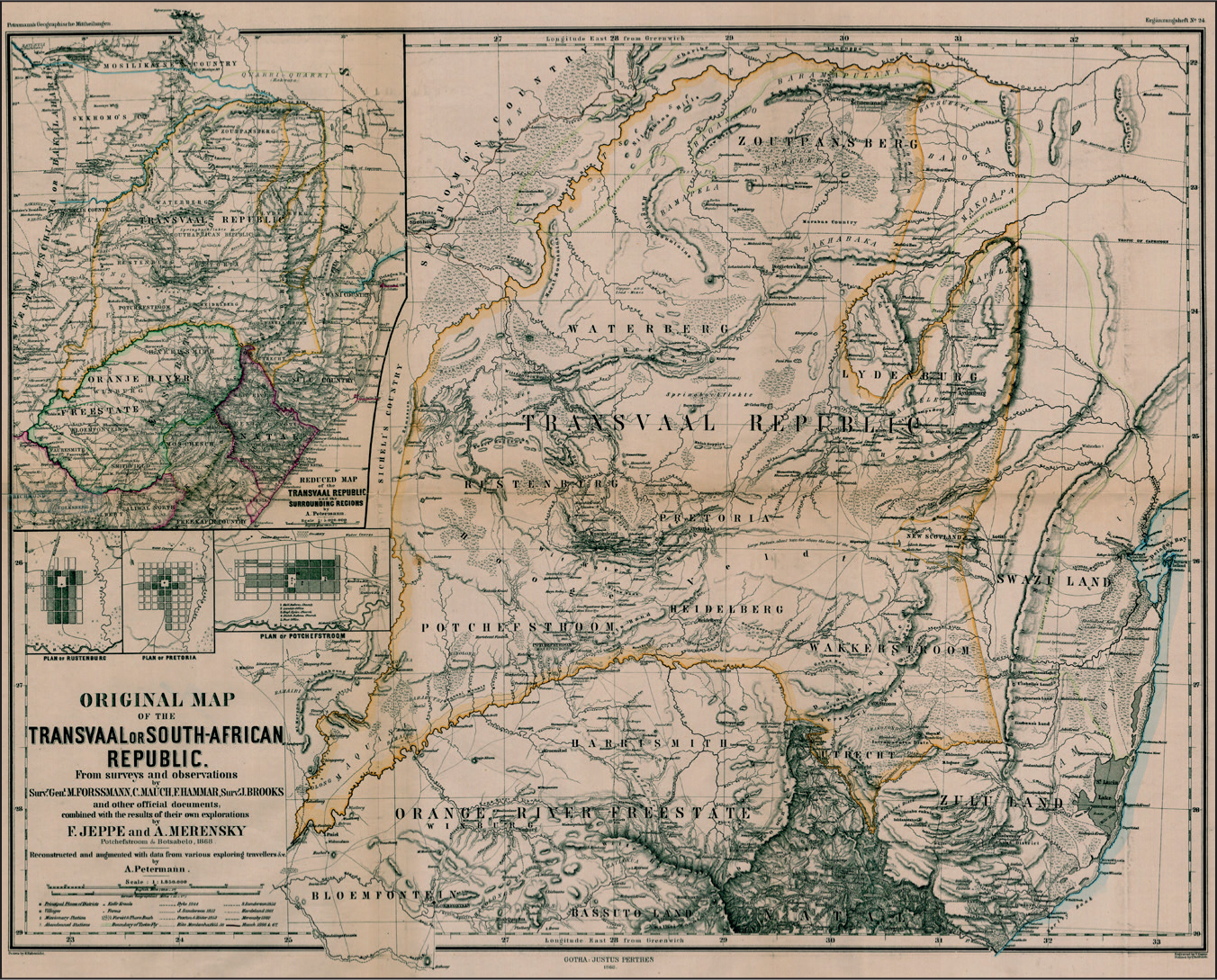
The story of the proposed survey law of 1874 began in 1871, although the need for systematic survey to pursue the European cartographic ideal was part of this discourse years before. August Petermann, the renowned geographer in Gotha, published the first map of the ZAR from the bureaucratic polymath Friedrich (Fred) Jeppe and Reverend Alexander Merensky of the Berlin Missionary Society in 1868 (see Figure
In November 1871, the sitting President, Marthinus Wessels Pretorius, and his State Secretary, Bernard Proes, resigned after the Volksraad rejected their acceptance of arbitration of the state’s southwest boundary by Governor Keate of Natal. 3 The award was deeply unpopular as it cut the ZAR out of claims on the diamond fields at New Rush (later Kimberley), which highlighted the connected issues of unsettled boundaries and uncoordinated governance. Initially, acting president D. J. Erasmus, commandant-general Paul Kruger and some others saw the union of the two Boer republics as a solution. Deputations met with President Johannes Brand of the wealthier and less fractious Orange Free State to the south in hopes he might seek election. Brand, however, was aware of the damage and opposition he would create if he pursued this idea. Besides, an attempt by Pretorius the prior decade to unify the republics under a single presidential officeholder had created a legal prohibition on holding both offices, and Brand employed this neutral legal shield. Brand, however, suggested an alternative, the Dutch-educated Reformed Church (Nederduitse Gereformeerde Kerk, or NGK) predicant Thomas François Burgers of Hanover in the Cape Colony, whose forward-looking and technical views of church and state had impressed him (Barlow, 1972, pp. 133–134; Engelbrecht, 1933, pp. 107–108; Van Jaarsveld, 1957, pp. 150–155).
Many of the roughly 2,600 burghers who had signed petitions in favour of Brand duly signed new petitions asking Burgers to stand for election. For some, particularly more conservative religious burghers such as Kruger and Erasmus, Burgers was as suspect for being a modernising outsider from the British Cape Colony and his NGK affiliation as his controversial stances against biblical literalism and divinity and the censure that he faced in the 1860s. Kruger and his abbreviated camp thus pressed long-time public servant William Robinson of Rustenburg into running in early 1872 even though Robinson himself—not to mention Pretorius—had signed the first Rustenburg petition asking Burgers to stand for election in December. 4 Their appeal did not mention Burgers, but they pointedly cited Robinson’s residence, service since 1840 and candidacy for the presidency in 1869 as his bona fides, in contrast to Burgers’s position as an outsider.
The petitions to Burgers, on the other hand, appealed to him as someone independent yet African-born, who would bring the guidance and education necessary for a young state—namely, a religious man who was not merely zealous but understood statecraft and would advance the material interests of this ‘fast developing young state’ and its people. 5 Burgers accepted this call, and promised to consolidate the government of the country through modern European legal reforms, attraction of investment, pursuit of peaceful relations with neighbours inside and outside the state and the honour of Christian morality and piety (‘land en volk, kerk en staat’). 6 As a liberal moderniser who addressed issues of piety, Burgers thus gained the support of the major Dutch Reformed Church branch in the Transvaal (Nederduitsch Hervormde Kerk, or NHK) irrespective of his background in the competing Cape NGK. This message carried far more weight than the belated entry of Robinson despite the latter’s receptivity to the unification of the republics. 7 Burgers won the election in April and May 1872 handily with over 88% of the vote and planned to take office on the first day of July (Engelbrecht, 1933, p. 109).
Another more important ally of Burgers in the ZAR was the powerful new state secretary of the ZAR, Dutch-born clergyman Nicolaas Swart, who succeeded Proes in November 1871. 8 Swart had served as a lay reader in Hanover in the 1850s, where he and Burgers met; despite his own agreement with Burgers, he moved to the Transvaal after 1859 and joined the ministry of the conservative secessionist Reformed Church (Gereformeerde Kerk, or GK) faction of Paul Kruger in Rustenburg (Spoelstra, 1989). However, he left the GK under a cloud after taking up his government post and soon joined the Anglican church in Pretoria (De Kock et al., 1968–1987; s. v. Swart, Nicolaas Jacob Reinier).
Swart wrote Burgers several letters during the election to assure him of the outcome and to identify some of his allies in government, including Fred Jeppe (who was postmaster general and treasurer of the republic in 1872), as well as some possible foes. These letters also warned the incoming president of obstacles to reform in terms that were alarmingly blunt:
And now when you come as president: Make a big bundle of your enthusiasm and when you cross the Vaal River drop it in the deepest hole. The people are widely different from the people in the Colony, and on Average stupid, they don’t read and frequently don’t understand. They are easily led away by any person who has brass enough and lies enough in proportion. It would not cost me a week’s time to get up a sort of a revolution. You shall frequently experience that with the best intentions you can do nothing. […] At first you will have it awfully difficult, you will have to convince the people of the falseness of the slanders and to bear with the slanderers and only then when you have got influence You can commence to do Your duty with the rascals.
9
This grossly unflattering portrayal encouraged Burgers to cultivate and emplace his allies as soon as he took office in July, which he energetically did.
Any attempt at reforms—survey or otherwise—would also need to fight the ‘slanderers’ with friendly press. The only running newspaper in the Transvaal, the Advocate in Potchefstroom, was geared more to English audiences. The new Mercury in the mining town of Pilgrimsrust would be similar. Burgers soon approached Jan Celliers, assistant editor at Het Volksbladin Cape Town, in August 1872 to set up a new newspaper in Pretoria (Barlow, 1988, p. 94; Engelbrecht, 1933, p. 131; Picton, 1969, pp. 86–87). Celliers agreed, and they began planning in earnest by November although setbacks and doubts delayed the publication of the new paper until August 1873. 10 This bilingual paper, De Volksstem, generally maintained a position in favour of reform throughout the Burgers presidency. Another acquaintance of Burgers, James Buchanan, came from the Cape to take up the role of attorney general in October 1872, with hopes he could bring Cape legal discipline to the republic as well. 11 Fortunately Swart, Celliers and Buchanan were not the only like-minded contacts Burgers drew from his Cape ecumenical and business circles.
Among Burgers’s close friends still at the Cape were the Marquards, who supported Burgers in his church disputes. He was particularly close with the mathematically gifted Leopold Marquard, who had been examiner of diagrams for the surveyor general in Cape Town since 1857 and was one of the most exacting and mercurial professionals working anywhere in the colonial establishment. Marquard also edited the theological monthly journal De Onderzoeker and dealt with technical questions of doctrine (Engelbrecht, 1933, p. 77). In writing to congratulate his friend in June 1872, Marquard put on his government cap and advised Burgers to ‘pay attention to the Surveyors’ office, then if you come up you can tell me how it is situated, and I can suggest a few things. That office is, in a new country like the Transvaal, one of the most important’. 12 A better advisor than the meticulous examiner of title deeds and surveys in the larger and older Cape Colony would be hard to imagine, and Marquard even helped to recruit promising candidates of like mind for civic positions. He knew many personally and professionally, like Jan Celliers, who only truly resolved to set up the newspaper in Pretoria in March 1873; he then informed Marquard, who informed Burgers. 13
Burgers therefore expected to pursue reform of land and survey offices, and the dire finances of the state further affirmed this course. The president enjoyed support from an ailing Magnus Forssman, who sought to step down from the post of surveyor general and return to Sweden. That desire opened the possibility of a comprehensive solution, which included a new survey law encompassing a general triangulation and survey of lands under a qualified, dedicated and precise new surveyor general. 14 Burgers and Swart duly requested information and sample documents in winter 1873 from the Cape Surveyor General, Abraham de Smidt, which he provided with Leopold Marquard’s full assistance. 15 De Smidt was also determined to improve the survey of government lands and extend the Cape’s partial network of primary triangulation that had stalled after the 1859–1863 work of the Royal Engineers on the southern coast; these measures resonated with Marquard and Burgers (De Smidt, 1876, pp. 10–11, 101–111). In the following year, Burgers and Swart would link Cape and Transvaal weights and measures using standard bars and masses they acquired from De Smidt and Marquard, which was an essential step in survey reform. 16
Devising an Ideal Survey Law, 1873–1874
The first specific move towards the general survey involved a meeting between Burgers, Forssman and land surveyor Arthur Walker on 17 October 1873. This was not the first time Burgers, his ministers or the overlapping Executive Council (Uitvoerende Raad) had heard voices advocating requirements for formal surveys. Land surveyor Edwin Griffiths of Nylstroom, in the badly afflicted Waterberg district, had made a scorching indictment of existing conditions directly to the Uitvoerende Raad in January 1873 and proposed progressive surveys going forward but not a network of triangulation. 17 Forssman subsequently appointed the combative Griffiths to be special examiner of inspections in March to help clear his backlog and, more likely, to continue being vocal and angry. 18 Likewise, Swart bent the ear of the speaker of the legislative council in the Natal colony, Walter Macfarlane, who in July 1873 suggested a similar idea of requiring survey for title and the slow completion of older districts by one government surveyor, but with no underlying triangulation. 19 De Volksstem duly published a long editorial in September casting severe doubts on the land registry unless the ZAR adopted a system like the Cape Colony’s. 20 By October, Burgers could count on support for a survey law beyond his inner circle. It is unclear exactly what Burgers, Forssman and Walker said, or when a high-level triangulation became part of the discussion, but Burgers included specific questions about trigonometrical survey in a letter he sent to Forssman and Walker the day after their meeting as well as recommendations related to the staffing, pace and costs of a general survey. 21
The initial idea that Burgers developed was to appoint a new surveyor general as well as a director of the trigonometrical survey, either separately or in person, and to require the survey of all lands. He envisioned triangulation working from small to large starting with individual surveyors’ work on blocks of farms, which was a reversal of the scientific ideal. The superintendency of trigonometrical surveys was a limited-term, twelve-year appointment, but the law allowed for its suspension if costs demanded. Other features included a system of exclusive survey districts, sized to assure a minimum amount of work to local surveyors without professional conflict, and draconian penalties—including five years’ hard labour—for damaging or moving beacons at property corners or trigonometrical points. This general scheme gained the official approval of the Uitvoerende Raad in November 1873 with a pool of sixteen surveyors. The total request for both activities was a meagre £2,250, which presumed the portion of fees returning to the treasury would assure the survey’s continuation. Fred Jeppe, wary of acting without a wider mandate, added a friendly amendment to the resolution acknowledging the need for approval from the wider Volksraad. 22
Happily, Burgers already had a candidate for the combined leadership position: Leopold Marquard, whom Burgers unsurprisingly offered the pending appointment at the beginning of January 1874. Burgers told Marquard that the Uitvoerende Raad had approved of the offer, but the surviving minutes from irregular December 1873 meetings do not record this, so it may have been his presumption. 23 Marquard’s obsession with correcting inaccurate and imprecise survey practices bordered on the quixotic, but even he apparently felt the challenge was overwhelming. In writing to Burgers’s wife, Mary, just after receiving the offer, Marquard noted that although his own wife was interested in moving to Pretoria and ‘the work to be done by me has many charms’, he was reluctant to give up his post with its long tenure, and at age forty-seven he felt he might be too old for it. 24 By March 1874 his feelings changed after he received several letters from Burgers that expressed the latter’s pleasure to work in a ‘rising country’ with his only lament being a shortage of ‘able men to assist’ in the transformation of the state. 25 That month Marquard wrote to Mary Burgers to express appreciation of the president’s vigour and sentiments, and he noted that the ZAR was clearly ‘making wonderful progress under Mr. B’s rule and I begin to feel a calling to lend him a helping hand’ to become such an able man. 26
Around that time, Burgers toured the contentious southwestern Transvaal boundary set by Keate in 1871. His companion was another Cape surveyor and personal friend, Samuel Melvill, who had relocated to the republic at the end of July 1873. 27 De Volksstem introduced Melvill to Pretoria as someone who ‘made his name in the old colony’ as one of its most trusted and skilled surveyors as well as an ‘open minded and aware’ person. 28 It is hard to know whether Burgers or Marquard hoped for Melvill to fill some particular role in a restructured survey office, but they shared a common opinion on the importance of survey. Furthermore, Melvill had significant managerial talents and experience with the resurvey of whole districts under the Cape office (De Smidt, 1876, P. 91). While touring with Burgers, Melvill communicated with Marquard and, at times, with Mary Burgers directly about the chronic health issues Burgers faced, reflecting a bond of loyalty and trust in confidential matters between them. 29 Indeed, Burgers wrote his wife while on tour that Melvill was ‘first-rate’ and that ‘when I get some more able and honest officials [in Pretoria] things will go on much better’. 30
The helping hand Leopold Marquard mentioned in March 1874 took material form in April, when he overhauled Burgers’s draft survey law into the form that would face the full Volksraad. This version, which survives in Marquard’s own hand among the president’s papers, changed few practical elements but incorporated far more detailed and precise language about the requirements of survey and matters of legal definition. The substantive revisions, however, emphasised the creation of reliable maps of the republic as a major goal, specified the trigonometrical survey as a geodetic one that was independent of block land surveys for the first time and placed the final say in boundary disputes with an appellate land commission of the surveyor general, the state secretary and the attorney general in the absence of a chief justice. 31 Marquard surely knew that Burgers’s allies would control the offices that made up the land commission and likely realised that no surveyor then in the ZAR could carry out geodetic work which would require technical training and personnel from Europe. These changes ultimately worked towards centralisation of planning, registry and assessment within technocratic government.
Such personal connections were also important in building financial and logistical connections outside the Transvaal. Leopold Marquard’s brother, Johannes, received an appointment as the sworn consul-general for the ZAR in Cape Town on the same January day in 1874 that Burgers offered the office to Leopold. Despite the position being unpaid he nevertheless provided a friendly conduit for the transfer of papers, goods and crucial funds between Pretoria and its representatives abroad until the first British annexation of the republic in April 1877. 32 Fred Jeppe too played a role in this process of securing funds, with his promotion of regular postal service and revenue stamps, as well as his efforts to bring more careful practices to the ZAR Treasury and so attract foreign capital that would propel these reforms including the general survey. The growth of networks that promoted and pursued technical solutions to perceived inefficiencies of the republic did not, however, mean that the ‘old Boers’ with power in the Volksraad, and the regular burghers who paid the bills, would accept costly modernising ambitions.
Failure to Reach Consideration, 1874–1875
When the Volksraad opened in September 1874, Burgers offered the customary opening address but made sure to showcase the proposed survey, right behind educational and legal reforms. He credited his awareness of the ‘true state of matters’ through citizen input for his ‘devoted attention’ to the question of a ‘proper trigonometrical survey of lands, along with all farms and government lands in the Republic’ under a comprehensive survey law. 33 The following item, unsurprisingly, was his intent to standardise weights and measures in the Republic to protect and promote trade. By then, the draft survey law had already appeared in the Celliers-printed Staatscourant(government gazette) and in summary form in De Volksstem, which invited ‘impartial discussion’ by tradesmen on its pages. 34 Through October, De Volksstem worked to keep public attention on the survey law and published supportive letters from Griffiths, among others, to shape opinion. 35
The question of the proposed law came before the roughly twenty-person Volksraad on 13 October 1874, with an impassioned speech by Burgers himself. The timing was, however, inauspicious because the sitting surveyor general, Magnus Forssman, had died just six days earlier. 36 Although Burgers’s ally Sam Melvill took over the post the next day, he could not attend, and the usefully volatile Edwin Griffiths was unavailable following an acrimonious argument over a diagram in August that led Forssman to revoke his status as a government surveyor, leaving Burgers without these experts’ voices. 37 The effect of surveyors’ absence is hard to assess, because Volksraad members in rural areas that faced these costs saw their support for a law that guaranteed them work as suspicious, but it foreclosed conversation about the technical elements of the law regardless. The Volksraad debate thus focused on whether a survey law should exist at all rather than the particulars of this draft, which was a frustrating level of disengagement for Burgers. Questions of cost and pacing arose, and Burgers was receptive to those amendments. 38 But according to recollections in De Volksstem months later, he had also declared he would sooner resign than continue the deceptions of the ‘corrupt’ system of land titling that existed, a level of hyperbole and frustration that damaged the tone of the entire session for the year. 39
This debate over mere consideration of the law resumed the next day. Burgers was no longer present to advocate for it, although Attorney General Buchanan and the chair of the Volksraad, Piet Joubert, gave long and impassioned pleas to adopt the law or some variation on it. Several of its supporters, though committed to technical solutions, declined to commit to the broad, immediate implementation that Burgers and his allies expected. 40 The result was anticlimactic: the Volksraad voted twelve to eight against considering the proposed law. De Volksstem castigated that failure at the time and again in its summary of the session in mid-December, suggesting that foreign speculators (‘land-jobbers’) and other profiteers opposed it to the detriment of the republic. The technocrats pursued other tasks in the immediate term—railways, legal reforms, education and diplomatic manoeuvres—while hoping to rekindle the survey law the following year. The president clearly tempered his hopes, and in his remarks to open the next Volksraad in May 1875, Burgers expressed reluctance to reintroduce the measure but also hoped that it might survive in some form. Instead of being the third or fourth item on the agenda, however, this second consideration of a survey law was the twelfth. 41
The pessimism was warranted. Summer elections had returned a different mixture of voices to the Volksraad, one that surveyor and railway speculator George Pigot Moodie—another Burgers ally—characterised at the start of June 1875 as ‘one of the worst I have known’ for putting internal posturing over economically geared reform and investment. Moodie warned Burgers, who was then in Europe campaigning for investment, that ‘if your stay is prolonged, your position may in some measure be jeopardized’, even with Piet Joubert acting in his capacity. 42 In dealing with questions of the borders of the republic, Joubert wrote to Burgers with some alarm about the need to inspect all land occupied by Africans under ZAR ‘patronage’ in order to define a full western boundary for the state, but he invoked the old inspection system in the process. 43
When the new Volksraad considered the question of a survey law at the end of May 1875, the deliberation was even more abstract than in October. A litany of repetitive worries emerged over costs, long-term liability and a growing number of memorials from burghers who now mobilised against paying survey fees. 44 Ultimately, the members decided blandly that ‘the sense of the membership of the Raad is against the survey, on grounds that the people in general oppose it’. The sole opposing vote to this sentiment arose only because they had no actual law before them to consider. 45 Populist principles rendered technical points irrelevant, and government officials expressed no surprise at the outcome. Other matters also militated against further discussion of a general survey of lands afterward, including military campaigns in the east of the Republic against African states that opposed ZAR expansion, British-led confederation proposals, looming bankruptcy and political infighting, the collapse of Burgers’ popularity and ultimately British annexation of the ZAR as the Transvaal Colony on 12 April 1877. Although a key purpose of the survey law was to put Pretoria’s finances on a sounder footing, it is unclear whether the 1874 law would in practice have generated the funds or encouraged foreign funds and credit that might have forestalled the political and fiscal crises of the 1875–1877 period.
Conclusion
This failure did not mark the end of efforts to advance survey in the north of the Vaal. Britain passed a survey law with a trigonometrical component through its hand-picked executive council in 1880, but this did not take effect before the Boer rising of 1880–1881 restored the republic north of the Vaal river. A Volksraad resolution in 1882 allowed inspections with a surveyor in attendance, but a comprehensive survey law with a triangulation only followed with Law No. 2 of 1884 (Jeppe & Kotzé, 1887, p. 1129). Finances kept the general survey inoperative until 1889, and some of it was scaled back in an amended law (No. 9) in 1891. A special commissions law (No. 3) of 1887 finally forced re-inspection of old blocks with a surveyor on hand, which provided a small check on gross errors of position in preparation for the general survey. Even then the triangulation network was ad hoc, more in line with the 1873 ideas of Burgers and Griffiths than the large-to-small plans of Marquard and later scientific actors, though some ZAR surveyors general tried to launch a permanent trigonometrical survey party (Braun, 2015, pp. 216–230). None of these laws made a meaningful start to a triangulation aside from adding an aspirational additional title for the surveyor general as the overseer of a trigonometrical survey that did not exist, but all of these moments still involved steps moving along the original line of travel that the proponents of the 1874 law had pursued. The geodetic survey only came about between 1902 and 1905, after the brutal experience of guerrilla warfare finally provided leverage to obtain temporary imperial funding for more reliable military and administrative mapping (Gill, 1908).
The year 1875 also did not mark the end of the actors and networks that pushed this first proposal. Although the annexation deposed Burgers, who died in 1881 in the Cape Colony, his confederates contributed to later efforts to enshrine trigonometrical surveys and related survey laws across the subcontinent. Leopold Marquard continued as examiner and author of mathematical reference works useful to surveyors. After initially shying away from high ambition and proposing only moderate survey schemes at the Cape, he and Abraham de Smidt together assisted the Astronomer Royal at the Cape of Good Hope, Sir David Gill, in promoting the resumption of geodetic surveys after 1879. After Abraham de Smidt retired in 1889, Marquard at last became surveyor general in Cape Town until 1892. Nicolaas Swart and Fred Jeppe, who fell out of favour in Pretoria in the two years before the annexation, quickly allied themselves with the new British administration that promised to continue technocratic modernisation. Sam Melvill remained surveyor general in Pretoria under British overrule and expanded that office if not its overall power. James Buchanan, on the other hand, took a central legal role in the neighbouring republic of the Orange Free State in 1875 (De Kock et al., 1968–1987; s. v. Buchanan, James). When the British administration departed in 1881, Jeppe became a collector of information and mapmaker instead of pursuing policy (Braun, 2018). Melvill returned to Cape Town in 1881 and became the permanent second assistant surveyor general there until his retirement in 1898. Swart also returned to the Cape in 1881, but remained in retirement. The new round of survey reformers in the ZAR after 1881 came mostly from the Cape survey establishment, and many had connections to Marquard, Melvill and others in Burgers’s circle.
This tale of networking and failed institutional modernisation shows that personal networks extend far beyond the creation or dissolution of a particular legal regime or organisation. The failure is in some ways ancillary, because the project of trigonometrical survey (and the general survey that it accompanied) had a variety of peripheral effects as well as peripheral influences; its echoes may be seen in efforts to restart larger schemes later in the 1870s and general surveys elsewhere. If we think about individuals in colonial states as communicating systems across time and space, we gain a broader understanding of initiatives like the Survey Law of 1874 as well as the wider modernising and scientific contexts and challenges around them.
Footnotes
Declaration of Conflicting Interests
The author declared no potential conflicts of interest with respect to the research, authorship and/or publication of this article.
Funding
The author received no financial support for the research, authorship and/or publication of this article.