
Abstract
Climate change and sea level rise present significant risks to coastal governments’ fiscal and service solvency. Current lack of focus on climate change by the U.S. federal and some state governments pressures coastal governments to develop tractable solutions to manage localized risks. This research integrates adaptive governance and capital planning literatures to develop an adaptive risk management framework. Heeding the call for research of coastal county actions to plan for and respond to climate change, we conduct content analysis of planning documents, financial reports, meeting minutes, media reports, and other documentation of all coastal counties in Florida to quantify government efforts to address climate change. Risk management practices are hierarchically categorized by focus area, risk type, and tactic and placed within the adaptive risk management process framework. A well-functioning adaptive risk management process can redefine vague climate change risks into knowable, tractable problems to address.
Introduction
Of the potential climate change challenges facing society, sea level rise (SLR) is one of the most apparent in coastal regions and threatens to enhance coastal flooding and saltwater intrusion into water supplies (Intergovernmental Panel on Climate Change 2018). SLR is expected to be one of the most socially and economically disruptive consequences of future climate change for low lying coastal regions (Hauer 2017; Hauer, Evans, and Mishra 2016). These disruptions pose risks to the sustainability of local governments, ranging from day-to-day challenges of delivering essential services to planning for large scale population shifts inevitable with loss of habitable land. Infrastructure that provides essential water supply, wastewater treatment, control of stormwater runoff, and transportation are all recognized as vulnerable to rising sea levels and intensification of existing flooding hazards (Allen et al. 2019; Fisk 2018; Hummel, Berry and Stacey 2018). Hauer, Evans, and Mishra (2016) estimate that, without adaptive measures in place, SLR could lead to population shifts of a similar magnitude to the Great Migration, as residents move from inundated areas to those not exposed.
Although federal and state governments can play key roles in shaping major climate change policy, SLR creates localized risks that can only be addressed in profoundly local political environments (Yusuf et al. 2016). As a result, coastal cities and counties face increasing pressure from the general public, media, and credit markets to develop strategic plans that address risks associated with SLR (Moody’s Investor Service 2017; Vella et al. 2016). To effectively plan for these risks, local governments must develop planning procedures capable of breaking their unique and complex problems down into politically tractable solutions (Brunner and Lynch 2010; Vella et al. 2016).
Yet, despite the significant risks that coastal governments face from rising seas, there has been relatively little research conducted on how they are strategically planning for such risks (Fisk 2018; Vella et al. 2016). This study helps fill this knowledge gap by conducting exploratory research on planning for SLR in all 35 coastal counties in the state of Florida. Florida has, by far, the most exposure to SLR than any of the 50 states, given its potential to lose 2.5 million residents by 2100 (Hauer 2017). Many Floridian counties already experience localized disruptions that serve as visible reminders of the realities of SLR, such as “sunny day flooding” where stormwater systems flood in response to the tidal seasons. Following the election of Governor Rick Scott in 2010, the state halted efforts by the previous governor to develop climate change policy, leaving local governments on their own to pursue initiatives related to SLR (Vella et al. 2016). Therefore, Florida’s coastal counties provide a rich cornucopia of implementation environments to study, given their exposure to SLR as a peninsula, lack of policy guidance from the state, and robust social, political, economic, and demographic diversity.
Our study investigates two research questions. First, given their tremendous exposure to climate change and SLR risks, how are Floridian county governments managing such risks? To answer this question, we provide a policy categorization scheme that classifies policies by focus area, risk type, and risk reduction tactic. Second, given these results, how does the content of current county policy align with normative process models from the adaptive governance and capital planning literatures? By normative process models, we refer to idealized models that depict how planning and risk management should be integrated with capital planning by performing a comprehensive evaluation of risks, developing options to eliminate or mitigate them, and systematically prioritizing capital investments. We develop an adaptive risk management framework that blends literature from adaptive governance and capital planning, and then explain the stages of risk management that counties have reached in planning for SLR.
Study findings indicate that Florida’s coastal counties are at the initial stages of the risk management process. They are beginning to define adaptation goals across diverse policy areas in light of data driven risk assessments that identify threats to water supplies, flood management systems, roads, public buildings, and other infrastructure assets. Progress among counties is eclectic, with select South Florida counties emerging as policy leaders with other major population centers beginning to mimic them. Effectively planning for SLR requires a comprehensive strategy for pinpointing risks, developing tactics to mitigate them, and prioritizing adaptive projects. Otherwise, policymakers lack the essential information they need to make decisions. Therefore, counties tend to progress sequentially through the framework, first by recognizing SLR as a problem, then planning to conduct vulnerability assessments to better understand risks, and with assessments in hand, developing feasible solutions. However, only a handful of counties have progressed to the end of the risk management process by developing prioritization schemes and implementing selected adaptive options.
The paper begins by explaining the rationale for blending the adaptive governance and capital planning literatures to develop our adaptive risk management framework. We then describe foundations of the framework and present its components. Next, the research design and data used to conduct the analysis are explained. Results provide a descriptive assessment of policy content and explain how current policies align with our framework. The paper concludes by discussing the contributions of this research to theory and practice.
Adaptive Risk Management Framework
Recently, the topic of climate change has received increased attention from the general public, elected officials, media, and credit markets (Moody’s Investor Service 2017; Moser and Ekstrom 2010; Sun Sentinel Editorial Board 2018). However, polarization in Congress has acted as a barrier to developing policy at the federal level, pressuring state and local governments to take the lead in developing actual policies. In South Florida, local governments have been pressed into action regarding SLR. For example, in 2017, voters approved the “Miami Forever” bonds, raising $192 million to combat the disruptive effects of SLR by making investments in adaptive infrastructure (City of Miami 2019). Furthermore, leading up to the 2018 elections, the editorial boards of the South Florida Sun Sentinel, Miami Herald, and Palm Beach Post joined hands in unprecedented action to “inform, engage, provoke and build momentum to address the slow-motion tidal wave coming our way” (Sun Sentinel Editorial Board 2018, paragraph 22). Thus, Florida’s counties provide an opportunity to study adaptation strategies at “ground zero”, potentially informing other coastal areas where SLR is beginning to surface onto the policy agenda (St. John III and Yusuf 2019; Vella et al. 2016; Yusuf et al. 2016).
Effectively responding to these pressures introduces several political and technical challenges to local governments. From a political perspective, conflicts emerge concerning general beliefs on climate change, the appropriate role of the state in assisting localities, and the prioritization and financing of relevant projects with local taxes and fees (Fisk 2018; St. John III and Yusuf 2019; Yusuf et al. 2016). From a technical perspective, such planning requires complex climate vulnerability assessments, involving the use of simulations of SLR and advanced geographic information systems (GIS) to pinpoint risks unique to the locality and help determine when action must be taken to eliminate or mitigate threats (Allen et al. 2019; Moser and Ekstrom 2010; Parkinson and McCue 2011).
Furthermore, a general criticism of climate research is its tendency to stop short of providing policymakers with feasible strategies for adaption (Dilling and Lemos 2011; Ford and King 2015; Lemos, Kirchhoff, and Ramprasad 2012; National Research Council 2007, 2009). As Ford and King (2015) explain, to effectively inform adaptation policy, studies must be designed to contribute to decision making processes with criteria for usable science in mind, especially pertinence, meaning that research investigates factors that policymakers can control and generates information relevant for decision making. In particular, the National Research Council of the U.S. National Academy of Science has been critical of progress in generating pertinent research that provides knowledge to support policymakers in analyzing risk and decision making (Dilling and Lemos 2011; Lemos, Kirchhoff, and Ramprasad 2012; National Research Council 2007, 2009, 2009b). Therefore, research is needed that assists policymakers in developing strategies for analyzing risk and breaking their unique and complex problems down into politically feasible solutions (Brunner and Lynch 2010; Vella et al. 2016).
The practical contribution of this research is that it provides local governments a blueprint for analyzing climate and SLR based risks across multiple service areas and incorporating new technical information into their established capital planning and budgeting processes. Specifically, we blend the adaptive governance and capital planning literatures to develop our adaptive risk management framework. Our rationale for blending these literatures recognizes the need for pertinent research dealing with factors that policymakers in local government can control, specifically decisions on land-use and capital planning within their own jurisdiction. We also recognize the need for timely research, given that many local governments are in the early stages of SLR adaptation (St. John III and Yusuf 2019; Vella et al. 2016; Yusuf et al. 2016).
Another motivation for integrating these literatures together is to combine their strengths and avoid the limitations of using either in isolation. For example, adaptive governance literature is critical for understanding the politics of climate change, evaluation of potential climate risks, and numerous barriers to local mitigation and adaptation. However, it stops short of addressing how this information should be incorporated into local capital planning and budgeting decisions or providing evidence that it has. Research in capital planning provides blueprints for integrating strategic planning and budgeting. Yet, it does so in a generic sense, with little regard for specific policy domains such as SLR adaptation which features its own fractious politics and lack of clear policy solutions (Yusuf et al. 2016). Moreover, like many climate challenges, effectively responding to SLR is complicated by the need to address multiple service areas and determining the ideal sequencing and timing of interventions in formulating a long-term adaptation strategy (de Coninck et al. 2018).
Thus, in addition to the practical contributions of this research, we also contribute to theory building by integrating these two literatures. To build our framework, we merged process models from the adaptive governance and capital planning literatures. By process models, we refer to frameworks that provide staged depictions of sequential steps to the planning cycle. Both literatures provide normative process models, meaning that they depict how planning should be done in an ideal sense. Below, we explain the literatures we draw on and how we bring them together to create our framework.
We use a simple approach to outline the capital planning process, separating recommended practices into major components, sequencing them, and incorporating basic guidelines for capital budgeting (Bland 2013; Ebdon 2004; Srithongrung, Yusuf, and Kriz 2019). These major components include comprehensive and strategic planning, needs assessments, long-term fiscal planning, and capital improvement plans. The literature stresses the importance of robust comprehensive and strategic planning to provide policymakers with the essential information they need to make effective capital budgeting decisions (Ammar, Duncombe, and Wright 2001; Bland 2013; Ebdon 2004; Srithongrung, Yusuf, and Kriz 2019). In general, this involves specifying the long-terms goals of community expansion, outlining future land use in accordance with these goals, developing proposals based on needs assessments and the condition of existing capital assets, and selecting projects that are feasible within budget constraints.
However, in the unique context of SLR adaption, informed decision making requires information that legacy systems often fail to provide. Specifically, local governments must use advanced geographic information systems (GIS) and simulations of SLR to pinpoint risks unique to the locality and help determine when action must be taken to eliminate or mitigate risks (Allen et al. 2019; Moser and Ekstrom 2010; Parkinson and McCue 2011). For example, in Brevard County, it was discovered that the majority of vulnerable roads are located along the intercoastal river and not the Atlantic Ocean (Neale 2018). Furthermore, these roads, in particular, have utilities underneath them, such as water and power lines vulnerable to erosion and potential damage from storms. Without conducting vulnerability assessments, local governments lack the ability to systematically prioritize and schedule projects in their capital improvement plans. Therefore, we look to the adaptive governance literature to outline a process for gathering the specific information needed to make these decisions and potential barriers to adaptation.
Moser and Ekstrom (2010) provide a framework to analyze adaption and barriers known to impede progress in adapting to climate change. Their idealized process model depicts concepts of “understanding”, “planning”, and “managing” as sequential stages of adaptation. Each stage is made up of generic subcomponents. For example, “understanding” is composed of problem detection, data gathering and analysis, and problem redefinition. The authors note that few adaptation processes have progressed beyond “understanding” because the barriers to adaptation are so significant and the process is relatively new to political agendas of local governments. Consistent with this general observation, research using this framework to study barriers to regional adaptation for SLR in Virginia discovers formidable challenges in the early stages of adaptation, with few governments progressing to the final stage of “managing” that involves policy implementation (St. John III and Yusuf 2019). Therefore, in this study, we focus on sub-components in the early stages, prior to implementation, such as problem detection, information gathering, problem redefinition, developing and evaluating alternatives, and selecting options to mitigate risks.
Our adaptive risk management framework is presented in Figure 1. As the left side of the figure shows, the framework is an eight-stage process model. For each stage of the process, components are displayed within the brackets. The components drawn from adaptive governance are italicized and those from capital planning are bolded. The arrows within the brackets indicate the sequential flow of the components. Finally, the right side of the figure provides a descriptor for each stage.
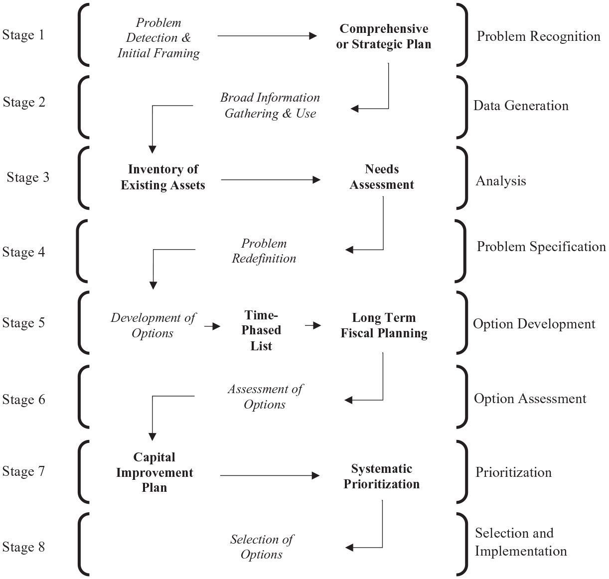
Strategic adaptive risk management framework.
In this framework, the recognition of climate change as a problem allows it to be incorporated into strategic planning documents that provide direction for information gathering policies. In an ideal process, information gathering involves securing funding, expertise, and technology to conduct vulnerability analysis specific to the locality (Parkinson and McCue 2011). For example, the potential future impacts of SLR can affect the population of a county in numerous ways, including saltwater intrusion that contaminates the water supply and corrodes infrastructure. In many cases, current disruptions such as nuisance flooding show that some neighborhoods are exposed to greater risk than others. Therefore, GIS databases must be upgraded to include the vertical elevation of water and key sewerage, electricity, and communication infrastructure (Allen et al. 2019). Data generation paves the way for specific risk assessments to be conducted on inventoried assets. To identify problem areas with precision, local governments must perform simulations of SLR and major storms to understand vulnerabilities to existing capital infrastructure and associated problems in service delivery (Allen et al. 2019).
Once this level of information is gathered, problems can be defined more specifically. Next, the development and assessment of options can begin in earnest. For instance, county governments can establish procedures for proposal development to ensure that policymakers have the information they need to make decisions, such as cost-benefit analysis. For these proposals to become actual projects, they must be approved and selected for inclusion in the capital improvement plan. Because counties are fiscally constrained and therefore limited in their ability to execute multiple costly projects at once, they must stagger them in a rolling capital improvement plan. Therefore, county governments need criteria to systematically prioritize projects to ensure that the most urgent ones are selected and scheduled.
This framework provides the basis to classify the stage of policy development that Floridian coastal counties have reached. In the next section, we describe the data and methods used to analyze adaption strategies for multiple services areas.
Data Collection and Methodology
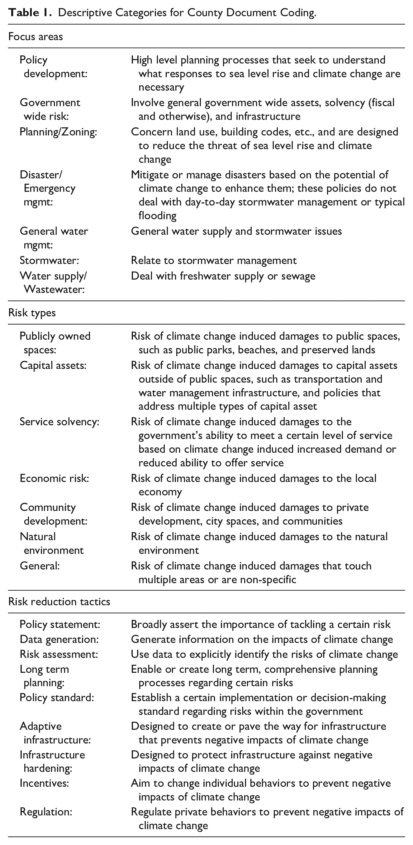
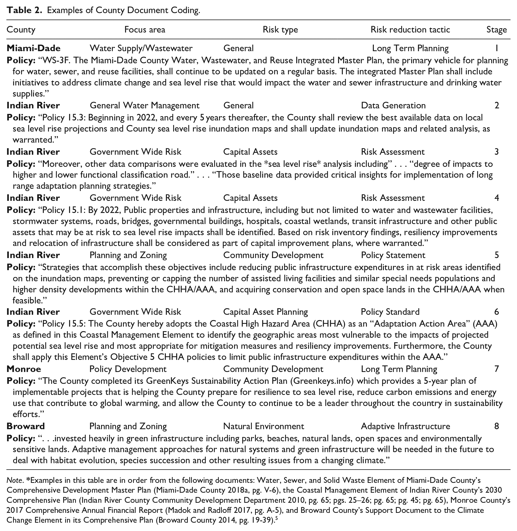
Given the exploratory nature of this study, our research design involves the collection of primary data from county government documents to unearth climate change and SLR risk management statements, activities, and policies. As Table 1 shows, we developed a categorization scheme to classify each policy instance by focus area, risk type, and risk reduction tactic. Next, we classified each instance to one of the eight stages of our adaptive risk management framework. By doing this, we provide a descriptive analysis of the focus areas that counties are most actively planning for and their relative progress.
Descriptive Categories for County Document Coding.
We collect relevant local documents to identify and compare local adaptation policy content and identify decision making processes (Vogel and Henstra 2015). To generate our data, we gathered comprehensive annual financial reports (CAFRs), county comprehensive plans (CPs), and Board of County Commissioner minutes. 1 The use of CAFRs and CPs allows for comparison across standardized financial documents and legally mandated planning documents. While governments may enact networks of interlocking adaptive plans, comprehensive plans serve as the principal platform for planning by coordinating numerous community efforts (Berke et al. 2015). CPs in Florida are required by Florida Statute and must address relevant topics including, but not limited to, capital improvements, future land use, transportation, and water management (Florida Statutes 2020). 2 Gathering minutes over fiscal years provides insight into the actual deliberations taking place among local policymakers. Finally, we also conducted a thematic media review to increase the validity of our findings and provide explanatory context on local circumstances.
The search of government documents yielded complete results for each coastal county apart from three. Once collected, documents were scanned using R for keywords including “sea level rise”, “resilience”, “adaption”, “climate change”, and “coastal flooding”. 3 We then read and analyzed all sections with matches, extracted specific text, and coded the policy instances. We operationalize climate change and SLR risk management practices as statements, activities, and policies that protect governments’ long run fiscal health, ability to provide services, and guard constituencies from climate change and SLR based risks. Our coding process intentionally leaves out mitigation-oriented practices, such as emissions reductions, to produce a manageable set of policy instances and ensure that comparable data was collected across counties. This data generation process gives a timely snapshot of each coastal county’s risk management policies.
Importantly, data collection reached a point of theoretical saturation in which gathering additional data from previous years did not lead to the creation of new descriptive categories of policy activity or add depth to the categorization scheme (Glaser and Strauss 1967). Moreover, our analysis of documents from recent years captures policies put into effect in prior ones. Thus, we consider the data sufficient to describe the theoretical concepts in our risk management framework. Altogether, 308 unique policy instances were collected and coded from the documents to form our final sample. All 308 instances were reviewed by the three authors for reliability, with final coding ameliorated in a concluding review session completed by the authors.
A media review supplements the document review. Keywords such as “climate change”, “high-sea level rise”, “resiliency planning”, and “flooding” were used in Google News searches for each coastal county. Approximately 90 articles were reviewed, of which 55 were archived and summarized. The review of the 90 articles helped identify each county’s operating environment by identifying key factors such as political climate, local actors, networks, rules, processes, locality specific risks, and financing tactics. Each of the 55 articles are directly relevant to local planning and budgeting, with coverage of 20 coastal counties. In some cases, articles regard actions of multiple cities or counties. For some smaller counties, information was not available on specific actions taken by those governments, especially those without a local news outlet.
Ultimately, analysis of these news articles was used as a strategy to increase the validity of our findings, where possible, and add explanatory context to our results from the review of government documents. In coding the observations for each county government, we referenced all associated news articles for the respective county. This strengthened our ability to report the stage to which individual counties have progressed and in making comparisons across counties and regions. For example, Martin County is located just north of the South Florida Regional Climate Compact (SFRCC) member counties. In coding the observations for this county, we noticed a dearth of policies and lack of depth relative to those in neighboring SFRCC counties. In reviewing media articles, a journalist was critical of Martin County for not joining the SFRCC, pointing out that the term “climate change” was cited just once in the county’s comprehensive plan and that little risk assessment had taken place (Smart 2018). Another general pattern that emerged in coding was that members of the SFRCC were further along than other major population centers on the coast, such as the Tampa Bay and Jacksonville metro areas. Here, we found articles consistent with these observations, with journalists making comparisons between the two regions and explaining that the recently formed Tampa Bay Regional Resiliency Coalition would be based off the SFRCC (Fears 2017; Pittman 2018).
Grounded theory undergirds the constant comparative methodology used to develop and refine our categorization scheme (Glaser and Strauss 1967). Specifically, to describe types of assets and services affected by SLR, risks within each asset and service category, and steps taken or planned to reduce risk, we conducted the document review by allowing categories to inductively develop as our extracted statements were compared to one another. The media review was done in parallel with the document review, with articles read to extract themes in climate change planning and provide additional context on each county’s efforts. Specifically, memo-writing during the media review stage identified themes in risk management and capital asset planning. Comparing the media and document review allowed us to better define categories and operationalize relations between them as the data was collected. This approach led to the development of a three-level categorization scheme that describes focus areas, risk types, and risk adaptation tactics.
As Table 1 shows, the first level of the categorization scheme describes the focus areas in which governments are developing risk management practices. Statements, policies, and activities that cut across focus areas are categorized as either comprehensive policy development or responses to government wide risk. Items that more directly address planning and zoning, readying for disaster, managing stormwater, and ensuring consistent water supply were assigned to specific categories.
The second level of the categorization scheme, risk type, classifies risks by government functions. This category encompasses risks to the physical assets that governments are responsible for, and their ability to continue providing key services and protecting their communities, given the potential for such risks to materialize. Under this definition, governments are striving to protect their capital assets, ability to provide services, publicly owned spaces, economic foundations, local private communities, and surrounding natural environment. 4 Finally, the third level describes the actions governments are taking to respond to risks. In Florida, our analysis indicates that some of the study counties are issuing policy statements, generating data, utilizing that data to inform specific risk assessments, engaging in long term planning processes, adopting policy standards, building new adaptive infrastructure, hardening existing infrastructure, and utilizing a blend of incentives and regulation to minimize their future climate change and SLR risks.
Each of the 308 policy instances were classified per the three-level categorization scheme and by the adaptive risk management framework. The instances were subjected to a consensus-based check by the authors as the final categorization was refined via constant comparisons between the coded statements and results from the media review. Multiple meetings by the authors were held to develop and massage the classification scheme and for coding of all documents.
In the following section, we first present results that describe how the coastal counties are managing climate change and SLR risks using our categorization scheme. Next, given these results, we explain how far along the counties have progressed according to our framework. To provide clarity in presenting our results, we divide the next section into two parts, beginning each part by summarizing key points, and then providing supporting details.
Results
How Are Floridian Coastal County Governments Managing Climate Change and SLR Risks?
To answer our first research question, we analyze focus areas to discover the types of risks being managed and tactics used to reduce exposure to these risks. To display our results for the multiple focus areas, we use treemaps containing boxes that are sized by observed policy counts. The treemap in Figure 2 shows the types of risks being managed within each of the focus areas. Figure 3 displays the tactics being used to reduce these risks for the focus areas. Finally, we use a map to indicate the number of policies each county has enacted in Figure 4.
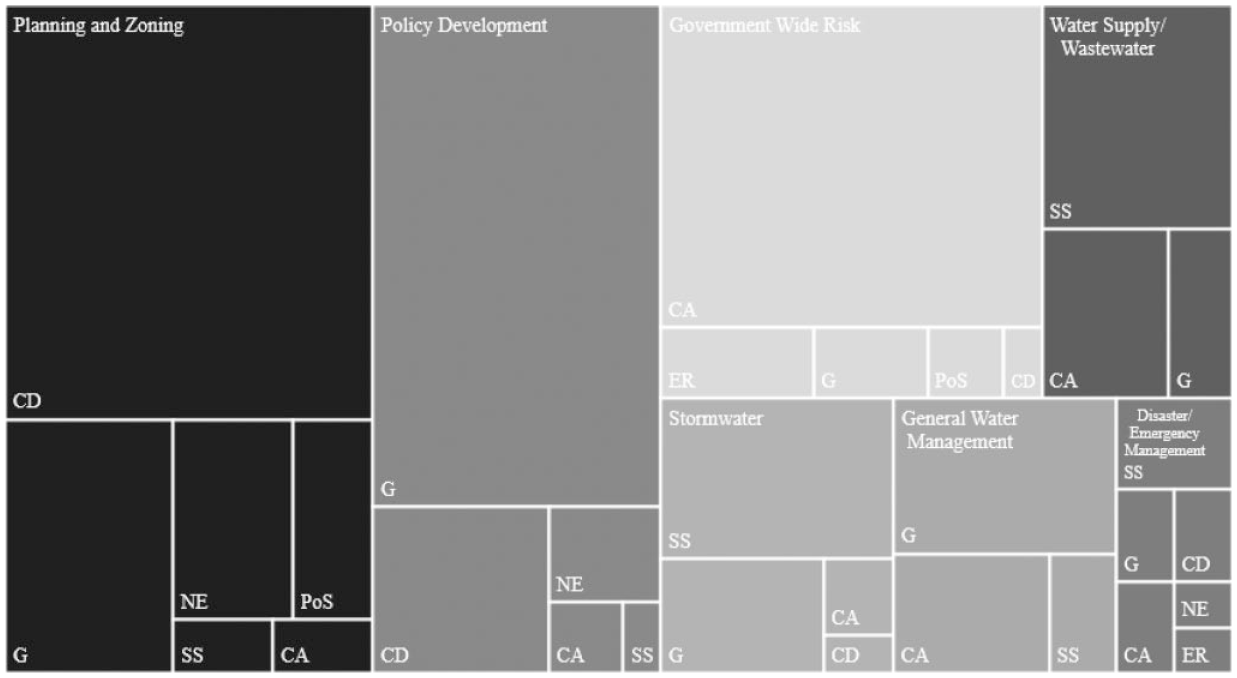
Risk types in focus areas.
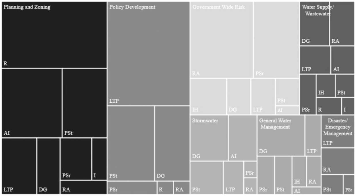
Risk reduction tactics by focus areas.
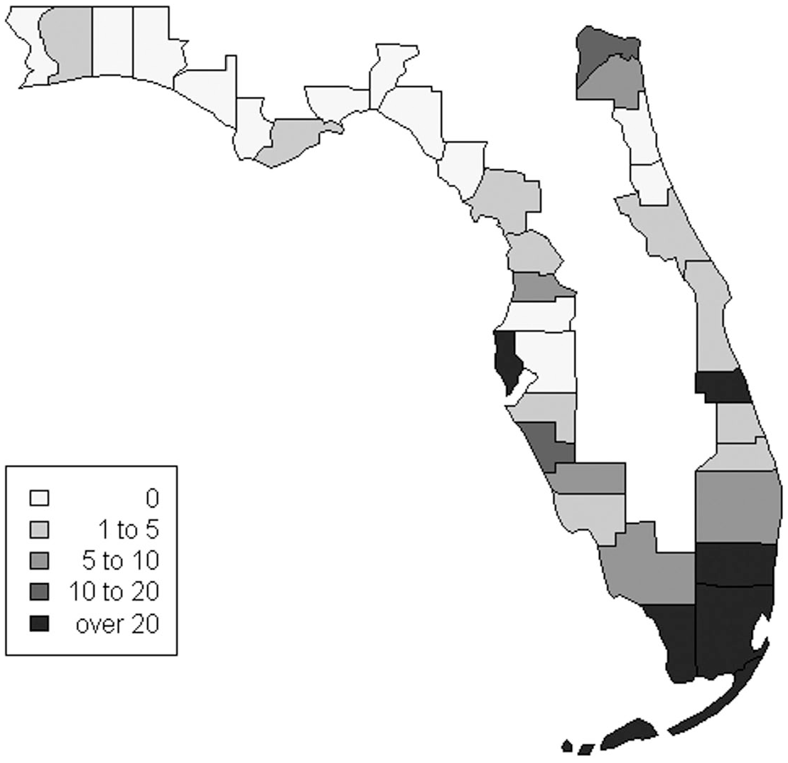
Coastal county policy count map.
At the summary level, results indicate that the focus areas county governments are most active in are planning and zoning, policy development, government wide risk, and various aspects of water management. However, we find that coastal counties have made very uneven progress, with counties in South Florida being the most active in developing policy. Below, we describe risk management tactics for these major focus areas. We begin by discussing policy development and management of government wide risks and then drill-down into planning and zoning. To provide structure by way of example in presenting results for these focus areas, we provide supporting detail for Monroe County, also known as the Florida Keys. We then describe risk management for water management systems, with special attention to Broward County.
The focus area of policy development concerns general planning processes seeking to create a unified response by centralizing responsibility for coordination at the county level and providing clear directives and assistance to departments. In this focus area, we find that counties most often identify general risks addressing multiple focus areas (Figure 2) and seek to reduce them in developing long-term plans (Figure 3). For example, Monroe County has completed its “GreenKeys Sustainability Action Plan” that provides a five-year plan of implementable projects to help the County prepare for SLR. Importantly, this schedule of projects was informed by extensive information gathering. As the County’s Chief Resilience Officer explained to the media, “We’ve done a lot of the modeling and the data gap filling and all of the studies over the past decade. . .We’re ready to rock and roll.” (Harris 2019, paragraph 8).
As Figure 2 indicates, in evaluating government wide risks, counties most frequently identify potential threats to their capital assets, such as public buildings, county roads, and water management systems. We find that the most common tactic used to reduce threats to capital assets is conducting risk assessments (Figure 3). For example, the county can establish processes to inventory capital assets and determine their exposure, if any, to SLR. Evaluations of government wide risk also include analysis of exposure to loss of habitable land that would result in major losses of tax revenue. In Monroe County, conducting these risk assessments has helped determine that a considerable amount of road elevation is necessary to meet basic transportation needs in the next 20 years, some fire stations must be relocated to maintain public safety, and new planning and zoning policies are needed to prevent damages to public and private property.
The focus area of planning and zoning concerns land use, building codes, and other policies intended to reduce threats of climate change and SLR. As Figure 2 shows, the most common type of risk managed in this focus area is community development, concerning potential damages to property in vulnerable areas. To reduce potential damages, counties are beginning to enact regulations that restrict new construction in flood prone areas and making investments in adaptive infrastructure (Figure 3). For example, Monroe County has been lobbying the state for funds to buy out homeowners in the wake of Hurricane Irma because new building codes call for elevating some homes at least an additional story (Harris 2019). Monroe County is also planning for costly road elevation, with half of their 300 miles of road network anticipated to be regularly flooded by 2040. Here too, Monroe County is seeking assistance from the state for these expensive projects that also require new infrastructure to collect, pump, and treat stormwater. For instance, following a pilot project, the County estimated a cost of $3.5 million to raise just 1 mile of road. To get started with various adaptive projects, the County has asked the state for $150 million. However, according to the head of Disaster Management for the County, “If we asked for what we actually needed, we’d be in the billions of dollars” (Harris 2019, paragraph 4).
Regarding water management systems, we distinguish between policies targeting the general water management system, those intended to manage stormwater, and ones dealing with water supply and wastewater systems. Collectively, these policies seek to manage capital assets at risk and ensure that governments can maintain service solvency in a future with more water from SLR. For water supply systems, this generally entails ensuring that saltwater intrusion is minimized, while stormwater systems generally must be able to continue providing protective services in the face of intensified flooding.
Broward County has developed strong information gathering and risk assessment processes to preserve its water supply and protect against future flooding. Broward’s Environmental Monitoring Laboratory along with its partners, the United States Geological Survey (USGS) and South Florida Water Management District, use a regional monitoring network to track and inform projections on the impact of SLR on saltwater migration. Broward has further partnered with the USGS to develop a county and local scale groundwater/surface-water model which simulates future scenarios. These simulations helped the County assess the capability of its drainage infrastructure to manage future flooding (Decker, Hughes, and Swain 2019). In terms of countywide SLR projections, Broward has generated new 100 year flood elevation maps to evaluate intensified flooding attributable to SLR.
Having explained the types of risks that counties are most actively managing and typical tactics used to reduce exposure to these hazards, we now explain how the content of policy aligns with the framework.
How Does the Content of Policy Align With Our Adaptive Risk Management Framework?
Figure 5 provides the number of policies evidenced at each stage of the framework and indicates how many of the counties have reached each stage. We find that most policies deal with earlier stages of our framework, beginning with recognition of SLR as a general planning problem and progressing to the development of options. However, there are noticeably less policies designed to help evaluate options, prioritize projects, and implement them, and few counties have even made it to these later stages. This pattern can be seen at the county level in Figure 6. As shown, only a handful of counties have progressed through each stage of the framework, many are in the earlier stages, and some have yet to define policies. To reiterate, counties in South Florida, specifically Monroe, Dade, Broward, and Indian River show the most progress. The remainder of this section describes the content of policy evidenced at each stage. In progressing through the stages, we reinforce the critical linkages among them for comprehensive and effective risk management.
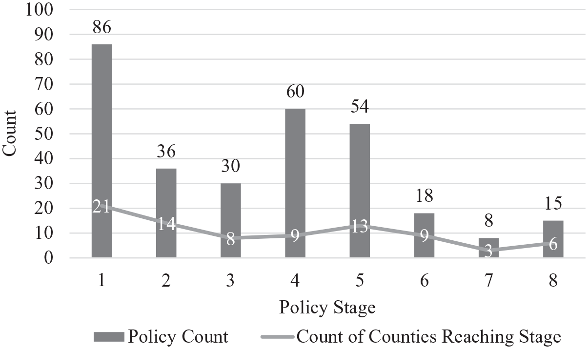
Counties and policies by stage.
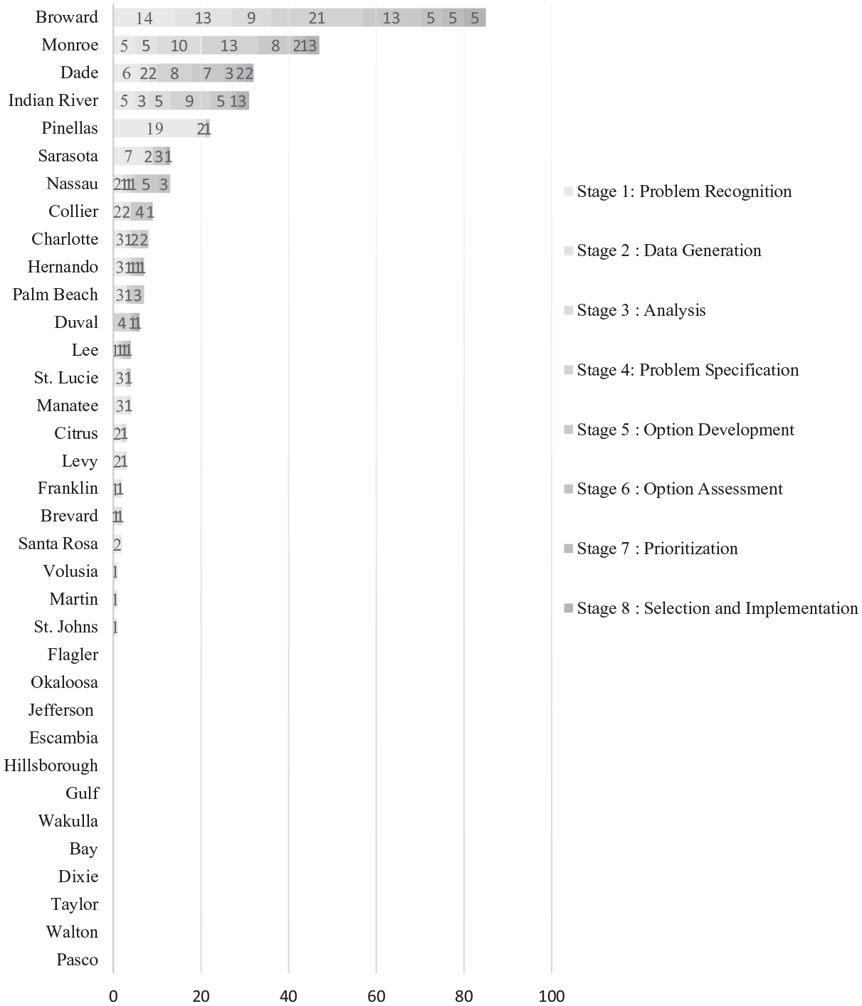
Policy counts by stage and county.
County governments enter stage one, problem recognition, once they acknowledge the need to respond to climate change and SLR based risks. We find that 60% of the 35 coastal counties have done so by issuing general statements recognizing such risks, beginning the process of incorporating them into their comprehensive plans. For example, Miami-Dade’s Comprehensive Land Use plan clearly identifies the need to plan for SLR in its water master plan (see Table 2). Importantly, Miami-Dade directly calls for initiatives to address SLR based risks that are anticipated to impact water and sewer infrastructure and drinking water supplies. Following this, they began to gather information to better understand threats to their water and sewer infrastructure by using advanced GIS modeling, SLR projections, and simulations of extreme weather events. Specifically, Miami-Dade has learned that rising seas have contributed to higher groundwater elevation making it difficult for septic systems to function properly unless they are elevated, with a study conducted by the County finding that the cost of capital improvements could reach over $3 billion (Miami-Dade County 2018b). In the context of our framework, these activities represent progression from stages 1 through 6, beginning with problem recognition and reaching assessment of options.
Examples of County Document Coding.
Note.
By engaging in robust information gathering, governments move from recognition of vague risks to identifying more specific problems for their respective focus areas and capital assets. Exactly 40% of the counties have defined policies for conducting formal risk assessments through a combination of advanced GIS analysis, incorporation of SLR projections to inundation maps, simulating extreme weather events, and inventorying capital assets and analyzing potential threats. Indian River County provides another illustration of how information gathering shapes problem specification. As shown in Table 2, the county plans on updating its inundation maps every 5 years based on SLR projections and using this to incorporate long-run adaption strategies into their capital planning process, such as resiliency improvements and relocation of public facilities.
As governments become more familiar with the scope and magnitude of their risks in earlier stages, they position themselves to make better decisions at later stages as they develop options and prioritize projects. Continuing with Indian River, they have developed specific options, such as reducing capital investments and capping the number of assisted living facilities in areas expected to be inundated in the future and acquiring open-space lands as a green infrastructure strategy to deal with enhanced flooding (see Table 2). In Monroe, Miami-Dade, and Broward, options have been developed to grapple with transportation needs, such as elevating specific roads and requiring that SLR and enhanced flooding be accounted for when building new transportation infrastructure.
However, many counties have yet to engage in extensive information gathering, limiting their ability to understand the totality of their risks and plan accordingly. For example, in coding policies for Palm Beach County, we found that relatively little information gathering had taken place and that vague options had been developed, especially in comparison to neighboring SFRCC counties (Monroe, Miami-Dade, Broward). These findings were validated in our media review which discovered that Palm Beach County is in the process of conducting a vulnerability assessment that will gather information on SLR impacts throughout the county as a joint initiative between the County and its cities. As the sustainability coordinator for the city of Boynton Beach noted, “We came to the realization soon in that process that none of us had done a vulnerability assessment”, adding that this was an “essential first step” in understanding climate risks (Morse 2019, paragraphs 7 and 8).
Once governments develop options based on robust information gathering, they need a process to help prioritize projects and incorporate them into capital improvement plans. Notably, we found this to be the least active stage, based on observed policy instances and the number of counties that have defined policies at this stage. Specifically, only Monroe, Miami-Dade, and Broward have developed such guidance. In Broward County, priority planning areas have been designated with environmental stewardship being added as an assessment factor in ranking transportation projects. Priority points are awarded to projects within SLR vulnerability areas that mitigate threats to infrastructure and are more resilient to extreme weather events. The need for a priority system is urgent in Monroe, given that half of the 300 miles of road in the Florida Keys have been flagged as problematic, requiring improvements by 2040 to meet basic transportation needs. Therefore, one focus of the GreenKeys initiative has been determining which road projects should begin now in the most vulnerable locations and which ones can be deferred. By developing priority ranking systems, policymakers are given objective information to help them analyze various adaptation projects, select feasible projects for inclusion in their capital improvement plans, and schedule them accordingly.
In sum, our results show uneven progress among the coastal counties. Specifically, 60% have recognized the need to respond to climate change and SLR based risks in their planning documents, and 40% have defined policies for conducing climate vulnerability assessments to better understand their exposure to SLR. However, only a few have progressed through each stage of the framework. 6 Of the 35 coastal counties, Broward, Monroe, Dade, and Indian River emerge as clear leaders based on the number of policy instances observed, progression through the framework, and media review. There appears to be less policy development in the Panhandle with few counties having even recognized SLR as a problem. One potential barrier to adaptation in the conservative Panhandle area are beliefs in climate change science. For example, when a Bay County Commissioner was asked about shoreline erosion, the response was, “Everything is purely speculation about climate change” (Breaux 2016, paragraph 8).
Concerning the use of media review to validate these results, we found examples of the press comparing the progress of counties in South Florida to each other and major population centers. For example, consider Palm Beach County, that we found to be the least active among counties in the SFRCC. The sustainability coordinator for a city in Palm Beach County explained to the press that “Many of the southern counties are farther along than we are with good reason, because they’re feeling the impacts more imminently” (Morse 2019, paragraph 12). The Director of Palm Beach County’s Resilience Office echoed this sentiment, noting that the slightly higher elevation in the county “does give us a little more time” to address SLR (Morse 2019, paragraph 13). Another example concerns counties in the Tampa Bay area. In conducting the media review, we found the press to be critical of the area’s progress, especially in comparison to South Florida, disclosing that the newly formed Tampa Bay Regional Resiliency Coalition (TBRCC) will be mimicking SFRCC policies as TBRCC begins to develop theirs (Fears 2017; Pittman 2018). As stated by the Executive Director of the Tampa Bay Regional Planning Council, they are in the process of determining “what areas are most vulnerable to sea level rise and climate change” (Pittman 2018, paragraph 5). Finally, counties in the Jacksonville metropolitan area also lag behind. The colloquially dubbed “Beach Mayors” have recently acknowledged SLR as a risk and the need for a coordinated response among their local governments (Pittman 2018; Rivers 2019).
Discussion
Rising seas pose a serious threat to coastal governments, but there has been relatively little research on how these governments are strategically planning for such risks (Fisk 2018; Vella et al. 2016). This research indicates that to effectively plan for SLR, local governments must evaluate risks across a vast number of municipal focus areas. Specifically, this study of Floridian coastal counties points to the need to manage risks for transportation, water supply, stormwater, and sewer infrastructure. Consistent with Allen et al. (2019), we find that these new challenges in planning call for enhanced GIS systems and simulation-based risk assessments to pinpoint risks for different service types and capital assets. Following such robust information gathering, counties can turn vague risks into scientifically and politically tractable problems, develop options, and use data-driven assessments to prioritize capital improvement projects and other preventative measures. Our adaptive risk management framework provides a blueprint for governments to incorporate these emerging technical activities into their established planning and budgeting processes.
We recognize that decisions to fund projects aimed at managing climate risks, in this case SLR, are inherently political in nature and highly localized. Climate change and SLR issues can encounter serious hurdles in becoming a key agenda item in local governments due to contentious beliefs on climate change, a corresponding lack of problem recognition, and a dearth of easy solutions (St. John III and Yusuf 2019; Yusuf et al. 2016). However, in the case of SLR in coastal counties, we maintain that a coordinated, comprehensive, and structured process is needed to arrive at politically feasible sets of solutions. Specifically, without engaging in robust information gathering and problem specification, the dilemma becomes unwieldy because planners are left without the technical information needed to develop alternatives for policymakers and help them prioritize projects.
Our research of the 35 coastal counties in Florida indicates that most are in the early stages of evaluating SLR based risks and incorporating them into their planning and budgeting processes. In particular, 60% have recognized general SLR risks in their comprehensive plans and 40% have defined policies for performing climate vulnerability assessments to define threats more specifically. Yet only a handful of the counties have advanced to the latter stages of our framework, namely developing criteria to prioritize adaptive projects and including them in their capital improvement plans. These results align with Moser and Ekstrom (2010) who find that few adaption processes have reached the implementation phase, with most in earlier stages of understanding (problem detection, information gathering, and problem redefintion) and planning (developing and evaluating options).
The primary contributions of this research are its ability to inform decision making, original research on SLR adaptation strategies, and potential to inform further theory development and empirical analysis. Heeding the call for research to support policymakers in evaluating climate risks and formulating strategies for adaptation, we conducted this research with criteria for usable science in mind (Dilling and Lemos 2011; Ford and King 2015; Lemos, Kirchhoff, and Ramprasad 2012; National Research Council 2007, 2009, 2009b). Specifically, our research is pertinent because it focuses on factors that policymakers can control, such as decisions on future land use and capital improvements. Moreover, our research is timely, given that SLR is a relatively new agenda item, with many governments in the earlier stages of formulating adaptation strategies.
This study also provides original research on SLR adaptation strategies, helping move scholarship beyond conceptual frameworks and toward empirical analysis of tactics implemented across multiple focus areas. We have blended the adaptive governance and capital planning literatures to create an adaptive risk management framework and policy categorization scheme, both of which can be used by other researchers in operationalizing adaptive measures. Our research can be viewed as complimentary to Berke et al. (2015) who developed a resiliency scorecard to evaluate the extent to which local plans target areas most prone to flooding and SLR hazards.
Having summarized our key findings and contributions, we now discuss how our research squares with foundational policy process literature. As Berry and Berry (1990, 2018) note, there are two principle explanations for the adoption of a new program or policy—internal determinants and diffusion. Internal determinants focus on how characteristics of a jurisdiction can lead to adoption whereas diffusion is fundamentally an intergovernmental concept, viewing policymaking, to some extent, as a copycat game. Regarding internal determinants, the general public and media are placing increasing pressure on elected officials for SLR solutions, as evidenced by the editorial boards of the South Florida Sun Sentinel, Miami Herald, and Palm Beach Post joining hands to raise awareness of the threats facing South Florida from sea-level rise (Sun Sentinel Editorial Board 2018). In addition, the state of Florida recently awarded 30 coastal communities with funds to combat SLR by analyzing vulnerabilities and developing plans to better handle changing coastal conditions (Florida Department of Environmental Protection 2020). Concerning policy diffusion, the earlier mentioned SFRCC has provided a roadmap for policy development and collaborative governance. For example, the TBRCC, established in 2018, is modeled directly after the SFRCC (Pittman 2018). Consistent with the policy diffusion literature, this points to potential mechanisms of diffusion involving learning, imitation, and normative pressure (Berry and Berry 2018).
As the advocacy coalition framework explains, actors form and maintain coalitions to achieve policy objectives in a coordinated fashion (Jenkins-Smith et al. 2018). In addition to the SFRCC providing a roadmap for policy development and collaborative governance, it may also be indicative of future efforts taken by local governments to collectively lobby to acquire financial resources to address climate change and SLR mitigation and adaptation strategies. As Vella et al. (2016) note, one of the primary purposes of the SFRCC is to serve as a lobbying vehicle. Our research found additional coalitions being established in Florida. For example, three members of the U.S. Congress from Northeast Florida, two Republicans and one Democrat, have joined the American Flood Coalition (AFC) and signed onto their campaign for increased spending on resilience and flood mitigation projects that address SLR (Patterson 2019). They, along with several other members of Congress and local elected officials, have joined the AFC, shedding light on potential strategies for reducing the financial burden of SLR resiliency projects.
We acknowledge the limitations of this research. Although some counties have a greater quantity of policies as measured by this study, this does not necessarily relate to the overall quality of any government’s risk management strategy. Here, we use nominal criteria to indicate the existence of policies and do not provide an ordinal measure of quality per instance based on further analysis of content. Moreover, we focus heavily on risk assessment and policy development and less on implementation. As a result, some of the policies we have documented may be delayed, partially implemented, or not reflective of future plans. Finally, county governments are just one layer of the complex intergovernmental arrangement that governs localities. Future research can improve on this work by developing ordinal measures of quality, collecting additional data on implementation, and conducting similar analysis for city governments. Finally, the nature of this exploratory research is descriptive. Future research can use local economic, financial, political, and environmental variables as explanatory variables for predicting stages of adaptive risk management.
Conclusion
For many local governments, there is no escaping the realities of SLR because they already experience regular disruptions from it, ranging from nuisance flooding to enhanced storm surge. Given the lack of consensus in Congress on the need to address climate change, coupled with the localized impacts of SLR, many coastal communities are likely to continue grappling with these issues on their own. Yet, despite pressures to adapt, relatively little research has been conducted on SLR adaptation strategies. The state of Florida provides an apt avenue to study SLR planning, given its peninsular geography and dozens of perimeter counties already dealing with visible effects of SLR.
This study of Floridian coastal counties shows that planning for SLR requires attention to multiple focus areas, especially transportation, water supply, stormwater, and sewer. Due to the localized impacts of SLR within a community, local governments must conduct vulnerability assessments that pinpoint risks to service solvency, future land use, and capital improvements. Effectively responding to SLR is further complicated by the need to develop feasible solutions based on vulnerability assessments, prioritize adaptive projects, and determine the ideal sequencing of them. Our adaptive risk management framework indicates that most counties are in the early stages of planning but only a handful have progressed to strategic implementation.
The contributions of this research include a framework for incorporating new climate information into established planning and budgeting processes, original research on SLR adaptation strategies, and potential to inform future research. Certainly, local governments in the early stages of SLR adaptation will benefit from studying strategies implemented in Monroe, Miami-Dade, Broward, and Indian River. It should also be the case that researchers focused on the intersection of climate change and planning can use this study as a guide to intertwine the adaptive governance and planning literatures to draw on their relative strengths and avoid the limitations of using either one in isolation.
Footnotes
Declaration of Conflicting Interests
The author(s) declared no potential conflicts of interest with respect to the research, authorship, and/or publication of this article.
Funding
The author(s) received no financial support for the research, authorship, and/or publication of this article.