
Abstract
In recent years, the rural–urban divide has become one of the defining features of American partisan politics. Usually conceptualized as a regional phenomenon, discussions of the rural–urban divide often overlook geographic polarization on the local scale and its impact on cities, urban governance, and urban problems. This research note draws attention to the growing political divide between adjacent rural and urban communities. First, this note demonstrates a method for conceptualizing and measuring the rural–urban divide on a local level. Second, through a case study of Wisconsin cities, it illustrates how the local divide has grown around nearly every city regardless of size, region, or type. Finally, this note explores several theoretical challenges that a growing local divide poses to cities and urban governance.
The growing political divide between rural and urban America has become a defining story of contemporary American politics. Over the last several decades, rural places nationwide have grown more uniformly and intensely Republican, while cities have become more consistently Democratic. Despite widespread discussion of the rural–urban divide, its impact on cities, urban governance, and urban politics remains underexamined. While some scholarship shows how this geographic polarization punishes cities in state and federal politics, relatively little has been written about its effect on local political life. This gap is driven, at least in part, by methodology. Many studies of the rural–urban divide rely on national surveys or county-level political data. These are well-suited to capture differences across regions but less attuned to conflict and division within them. Approaches to the rural–urban divide must be refined and rethought to capture the impact of growing geographic polarization on cities and urban governance.
This research note has three goals. First, I demonstrate a method for measuring the rural–urban divide at a local level. Second, I illustrate the reality of that divide through an empirical case study of Wisconsin cities. Third, I consider several theoretical implications of this growing local divide for urban governance and urban politics. Drawing on precinct-level election data, I construct a multilevel model that describes the partisan divide within and across counties. Through a case study of elections in Wisconsin from 1990 to 2020, I show that nearly every city in the state—no matter its region, size, or demographics—has become politically distant from its immediate neighbors. I demonstrate that this local divide persists across different years, types of elections, and methods for categorizing rural and urban places. Finally, through illustrative examples from cities across Wisconsin, I propose several ways that exploring this local divide may be helpful to the study of urban governance and urban politics. While the precise model used in this paper may be specific to Wisconsin, the idea can and should be explored in other states. When understood as a local phenomenon, the rural–urban divide provides ample opportunities for future research for urban scholars. Urban scholars have considerable insights to offer the broader political discussion on the U.S.'s geographic polarization.
Cities and the Rural–Urban Divide
It is well-documented that rural and urban Americans have grown more politically, socially, and culturally distant (Enos 2017; Hopkins 2017). While considerable debate exists about defining, measuring, and explaining the rural–urban divide, few doubt its importance to contemporary U.S. political life (Abrams and Fiorina 2012; Lang and Pearson-Merkowitz 2015). This partisan divide derives from and reinforces the lack of social interaction between rural and urban Americans (Gimpel et al. 2020), their distinct social and economic identities (Kelly and Lobao 2019; Lyons and Utych 2023), and their increasing resentment toward one another (Cramer 2012). The goal of this research note, however, is to explore the ways that proximity—not only distance—between rural and urban Americans can produce resentment and political conflict. For, though this divide is typically presented at the national level—analyzed as a growing division between disparate and disconnected rural and urban states or counties—there is a growing body of literature showing increasing polarization within counties and metropolitan areas, as cities grow more politically distant from their immediate neighbors (Kinsella et al. 2021; Rohla et al. 2018; Walker 2013).
It would be a mistake to say that cities have been ignored in the debates about the rural urban divide. Indeed, rural sociologists have rightfully criticized scholars of geographic polarization for ignoring the diversity and complexity of rural life (Kelly and Lobao 2019). The analysis of geographic polarization's causes tends to focus on urban life's dynamism, density, and diversity (Gimpel et al. 2020). Discussion about the consequences of the rural–urban divide has focused on how cities are punished in state and national institutions that overrepresent rural Americans (Rodden 2019; Mettler and Brown 2022). However, research should further explore the impact of local political polarization between cities and their immediate neighbors on urban governance, politics, and problems.
Scholars of urban governance have tools to explore how local divisions inform, constrain, and empower local politics. However, these traditions rarely break through into broader discussions of geographic polarization. Recent scholarship has explored the growing spatial cleavages in urban life, documenting the diverging political and economic fates of neighborhoods and communities within the same metropolitan area (Doering et al. 2021; Schachner 2022). Other scholarship emphasizes the symbolic dimensions of local division, as residents and policymakers draw cultural boundaries between different parts of a city, region, and county (Neves and Neves 2024). These boundaries can harden into realities as voters and politicians make political decisions reinforcing and legitimizing these differences (Godinez Puig 2024). With decision-making authority within regions fragmented across a number of local jurisdictions (Savitch and Adhikari 2017), these local divisions present new challenges for urban governance, new potential for conflict, and demands for collaboration (Lee and Lee 2022). Recasting the rural–urban divide as a local phenomenon between urban centers and their immediate neighbors, as well as small cities and their rural surroundings, helps illustrate the value that urban scholarship can bring to the ongoing debates on geographic polarization.
Methods and Data
The data for this paper come from the Wisconsin State Legislative Technology Services Bureau, which publishes a dataset containing election results and census population estimates for every precinct in the state. 1 Each precinct is nested within a community (city, village, or town) and a county. Every Wisconsin voter lives in a city, village, or town. The first two are incorporated communities, and the latter is unincorporated territory. Precinct-level analyses have frequently shown that partisan divides in the U.S. are larger and more significant than seen at higher levels of abstraction (Rohla et al. 2018). This analysis builds on that work by showing how polarization measured at the precinct level can reveal a rural–urban divide in a wider range of communities and contexts than often seen in other analyses. It builds on other work that examines the precinct-level dimension of rural–urban polarization (see, e.g., Rodden 2019) by showing that this divide exists in most communities, not just on the outskirts of large cities and historic manufacturing centers.
The outcome variable for this analysis is the Republican share of the two-party vote, calculated at the community level for every city, village, and town in the state. This is measured for presidential, gubernatorial, and congressional elections from 1990 to 2020. Analyzing data across these several types of elections helps demonstrate that the local divide is not an artifact of the particularities of presidential candidates or national races. Future studies may consider replicating this analysis with the proportion of registered Democrats and Republicans in rural and urban places. However, that is not possible in Wisconsin (or several other states), which has nonpartisan voter registration.
The primary independent variable is the rural or urban nature of each community. I propose two definitions for rural and urban communities at the local level. First, I compare the administrative seat of each county (usually also its largest city) with all other communities in the county. This approach highlights the challenges of a particular city in managing political conflict with surrounding communities, but it is less able to examine rural–urban polarization between several small cities and their rural neighbors. The second method, comparing incorporated communities (cities and villages) with unincorporated communities (towns) in a county, helps address this flaw. However, this approach speaks less to the political experience of any one city and may blur the differences across places of dramatically different sizes. The difference between towns and municipalities may also not perfectly map onto our cultural notions of urban and rural. Portions of villages and cities may feel truly rural, and some rather large settlements have chosen (for a variety of political, economic, and cultural reasons) to remain unincorporated. However, unincorporated towns typically have fewer people and more loosely connected populations spread across larger swaths of land; cities and villages are denser, more clearly defined communities. The advantage of this definition is that it recognizes that many communities have a divide between places that feel more or less urban or rural, which may be overlooked by less fine-grained analyses. Testing both definitions shows that this method is adaptable to different contexts, research questions, and conceptions of rural and urban. A small percentage of municipalities (7.5%) cross county lines. Because this analysis is structured at the county level, I count each segment of a divided municipality as a city or village in each respective county. I only count the portion of a city within the county that it is the administrative seat as a county seat.
I conduct this analysis using a multilevel fixed effects model in which communities are nested within counties. I use this model to calculate the predicted margins of Republican vote share in rural and urban areas within counties and show that this divide has grown statistically and substantively significant across all election types in recent years. While it is difficult to obtain demographic data for the rural and small communities in this analysis, the Legislative Technology Services Bureau (LTSB) data contain basic population and racial demographic estimates from the 2010 census. I use these data to control for key demographic characteristics of each community's population as a robustness check on the most recent elections to show that the local rural–urban divide cannot be explained entirely by population size or the racial demographics of these communities.
Not every state is organized into counties combining rural and urban areas (Virginia, for example, is divided into counties and independent cities). One limitation of the proposed method is that it may not translate precisely to other states. Studies in such places might consider analyses at a slightly larger geographic scale that do combine rural and urban places, including regions, legislative districts, etc. Alternatively, studies could classify places as rural or urban based on their distance from an urban core.
The data used in this analysis have some limitations. The dataset reports historic election results using the 2020 precinct and municipality boundaries, reestimating previous election results on that map. The primary concern in using this dataset to study the rural–urban divide is that it may misclassify territory incorporated or annexed into municipalities between the election date and 2020. As a robustness check, I have analyzed both the 1992 and 2000 presidential elections using the election results as originally reported. These results accurately reflect rural and urban classifications at the time but are not available in a systematic, digital dataset. In both years, this analysis finds a local divide quite similar (within a percentage point) to the one documented with the LTSB data. 2
I supplement this primary analysis of voting patterns across Wisconsin with several examples demonstrating the importance of the local rural–urban divide to urban governance and politics. These examples are drawn from a review of public records of government meetings and local media coverage from several cities across the state. My review of these records targeted midsize cities because they are more likely to immediately border rural communities and exemplify the consequences of this local divide. I focused my review on the period from 2020 to 2022 because my primary analysis suggested that this more recent moment would see the most intense local geographic polarization. This is not a systematic or exhaustive analysis of how rural–urban polarization may shape urban governance; rather, it is a set of illustrative examples meant to highlight the questions and directions that future research may pursue.
Case Justification: Why the Local Divide in Wisconsin?
Wisconsin is an ideal state to study the development of the rural–urban divide in American politics. Although the political competition between rural and urban places has dominated the state since its inception, the partisan valence of this divide has not always been stable (Fowler 2008). Cramer (2012), however, showed that in recent years, partisan politics have been grafted onto that rural–urban divide, with rural places growing increasingly Republican and cities increasingly Democratic. Further studies have confirmed this partisan geographic polarization in Wisconsin and many states nationwide (Brown and Enos 2021; Johnson and Scala 2022). This divide is of particular importance because of Wisconsin's razor-thin partisan margins and significance to national politics: four of the last six Presidential elections in Wisconsin have been decided by less than one point, and the precise breakdown of rural and urban electorates have been critical to this outcome (Johnson et al. 2024). While the regional divide between Wisconsin's largest, “bluest” cities and the rest of the state has received the bulk of scholarly and popular attention, a local partisan divide between adjacent rural and urban communities has grown during this same time.
Although Wisconsin's experience may be typical of other states in some regards, it is less representative in others. Wisconsin is close to average for the country in terms of the balance between rural and urban communities. The state ranks 27th out of 50 in population density, and 32nd out of 50 in percent of the population that is urban (ICIP 2024; U.S. Census 2020). This balance between rural and urban communities makes the state a critical case for the study of geographic polarization. However, the findings presented here may look different in those states that are quite a bit more rural or urban. Wisconsin has comparatively low economic inequality, but significant racial disparities and segregation (Dresser 2019; Dresser et al. 2024). Each of these may inform how the local rural–urban divide unfolds, both tying communities together and amplifying conflict between them. Again, this may look different in states with more intense economic inequality or less significant racial disparities. Finally, Wisconsin has particularly intense political polarization, including intense conflict between the parties in state government and significant investment in the state and federal partisan campaigns (Friedland et al., 2022). This may intensify the partisan divide between neighboring rural and urban places as political actors look to exploit conflict to expand their narrow margins, and this divide may look different in places that see less significant partisan contestation.
A final aspect of this case that merits explanation is Wisconsin's organization of local government. Wisconsin is divided into 72 counties (although for this analysis, I exclude Menominee County, which is made up entirely of the Menominee Reservation, has different governing structures, and is not divided internally into separate municipalities or towns). Counties have elected boards and elected or appointed executives who manage a range of government functions, including courts and vital records, highway and road maintenance, public health, and election administration (Wisconsin County Association n.d.). Counties are divided into municipalities (cities and villages) and unincorporated towns. Municipal governments have “home rule” and relatively broad authority to manage taxation, regulation, investment, and development within their borders (Silverman and Davis 2023). Towns, which are more sprawling collections of properties, maintain more limited governments that manage only a few select powers (property tax collection, fire, and ambulance services, road maintenance, etc.) granted them by state law (Wisconin Towns Association n.d.). This structure binds and divides adjacent rural and urban areas, making the local polarization documented here critical to the function of local government. Other states with different organizational structures—different ways of defining municipalities, less interconnection between rural and urban places, and different powers given to county or regional governments—may see both a substantively different local divide and require an altered methodological approach to study it (see Anderson 2008, Nelson 2011, and Nelson and Svara 2010 for discussions of how municipal structures and unincorporated territory vary across states).
Case Study: Wisconsin Cities and the Local Divide
This research note proposes two ways to conceptualize and measure the local partisan divide. Figures 1 and 2 plot the coefficients for the difference in Republican vote share between rural and urban places within a county by year for each of the four types of election analyzed (the full results are in Tables 1 and 2). These figures show that both approaches reveal a significant and growing divide between rural and urban places within Wisconsin counties. The first measure finds that, in 2020, the average county saw Trump underperform by 12 points in county seats compared to other communities (50.3% vs. 62.3% of the vote). This divide has grown steadily over the last several decades and has more than tripled in magnitude since the 1990s. For comparison, the difference between the county seat and other municipalities within the average county is roughly the same magnitude as the difference between the 25th and 75th percentile most Republican counties in the state. The second measure tells much the same story. In 2020, Donald Trump performed 14 points worse in the average county's incorporated cities than its unincorporated rural towns and 7 points worse in cities than (typically smaller) incorporated villages. Again, this local divide between cities and towns has more than tripled across the period studied.
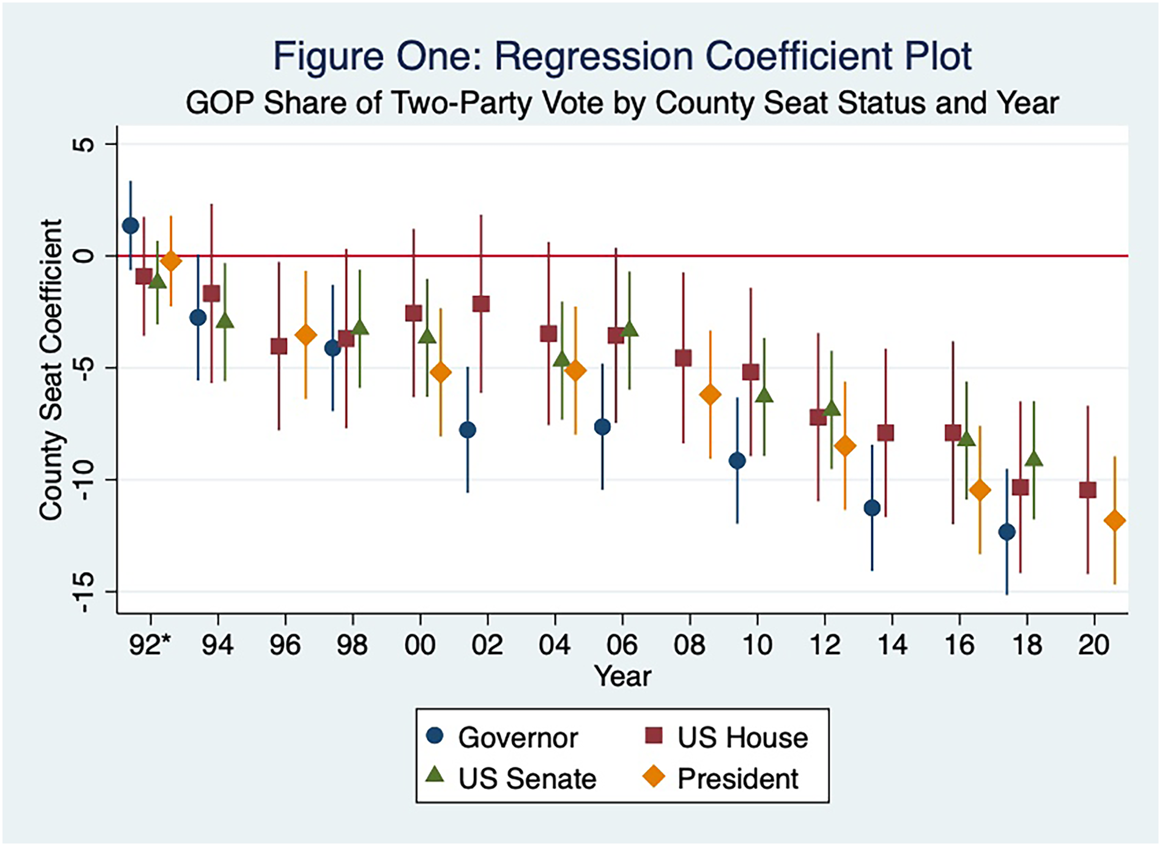
Regression coefficient plot: GOP share of two-party vote by county seat Status and year.3
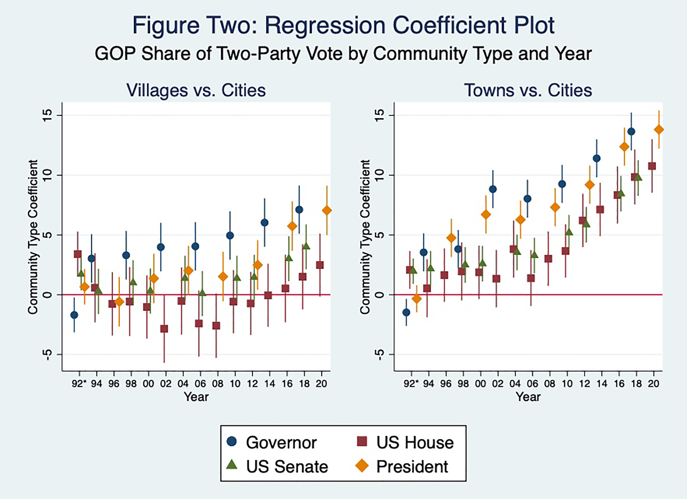
Regression coefficient plot: GOP share of two-party vote by community type and year.4
Multilevel Regression of Republican Share of Two-Party Vote Comparing County Seats and Other Communities Within Counties, 1990–2020.
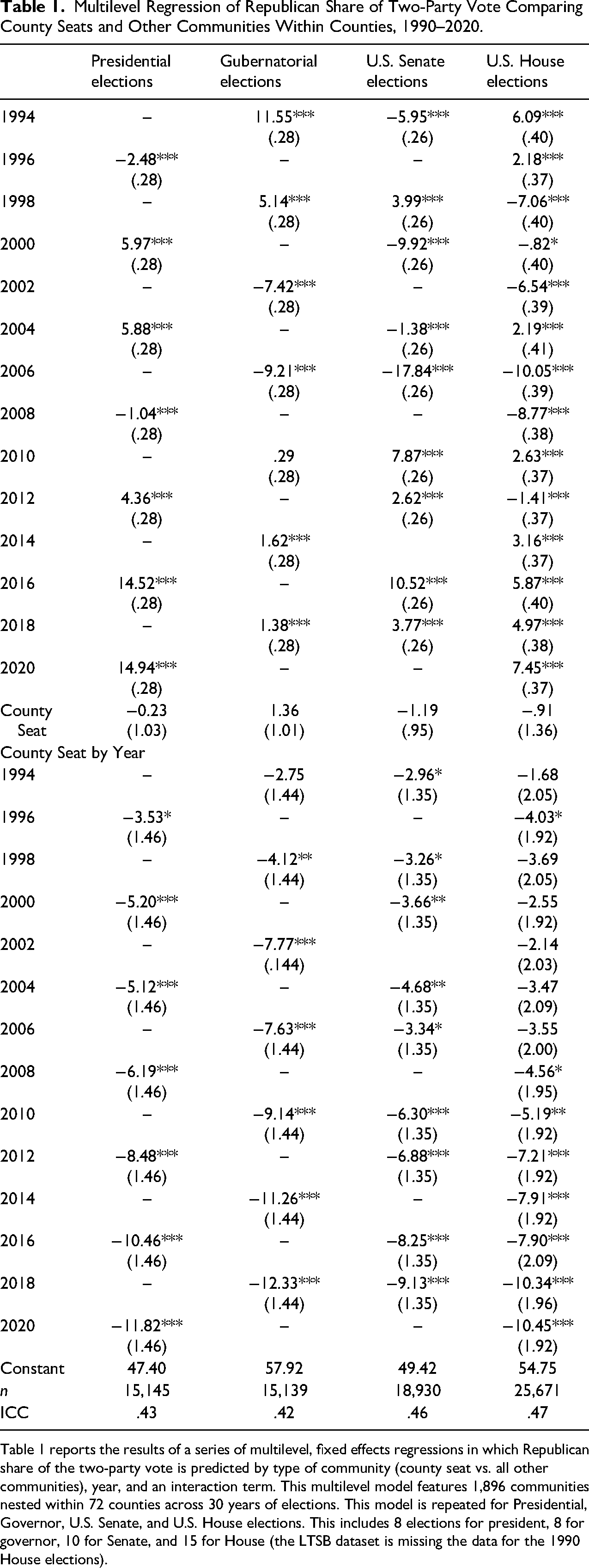
Table 1 reports the results of a series of multilevel, fixed effects regressions in which Republican share of the two-party vote is predicted by type of community (county seat vs. all other communities), year, and an interaction term. This multilevel model features 1,896 communities nested within 72 counties across 30 years of elections. This model is repeated for Presidential, Governor, U.S. Senate, and U.S. House elections. This includes 8 elections for president, 8 for governor, 10 for Senate, and 15 for House (the LTSB dataset is missing the data for the 1990 House elections).
Multilevel Regression of Republican Share of Two-Party Vote Comparing Cities, Towns, and Villages within Counties, 1990–2020.
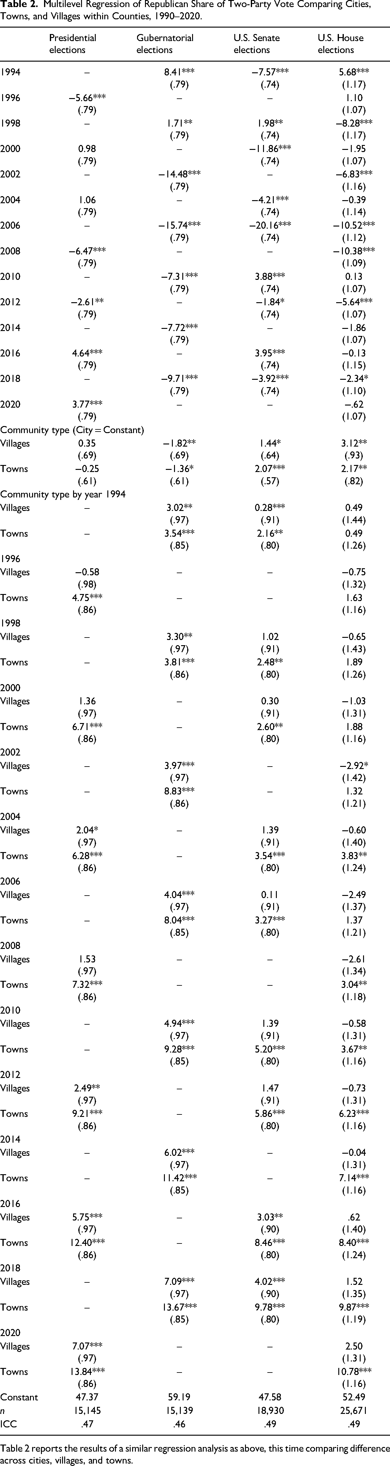
Table 2 reports the results of a similar regression analysis as above, this time comparing difference across cities, villages, and towns.
This divide goes beyond recent presidential elections. In 2020, across eight contested House races, Republican candidates performed an average of 10 points worse in county seats than in other communities; Republican candidates performed 11 points better in rural towns than in incorporated cities in the average county. In 2018, when Democrat Tony Evers eked out a 1-point victory over Republican incumbent Scott Walker, Evers also performed 12 points better in county seats than in other communities and 14 points worse in rural towns than cities in the average county. The 2018 Senate election between Democrat Tammy Baldwin and Republican Leah Vukmir—which was far less competitive on the state level (Baldwin won by 11 points)—still saw a sizeable local divide.
Three cities—Racine, Hudson, and Adams-Friendship—demonstrate this growing local divide across the rural–urban continuum. Just outside of Milwaukee, Racine is an old working-class city of nearly 80,000 with longstanding Black and Latinx populations. Racine County, which stretches west to more rural areas, is 87% urban. Adams-Friendship, twin cities at the center of the state, have a combined population of just 2,000. Surrounding Adams County is one of the most rural in Wisconsin, with only 13% living in incorporated communities. Finally, Hudson is a city in transition. A fringe Minneapolis suburb, Hudson's population (15,000) has more than doubled in the last 30 years. Half of St. Croix County (where Hudson is the administrative seat) is urban.
Despite their different sizes, regions, and rurality, each of these cities presents a considerable partisan difference from adjacent communities. In 2020, Donald Trump received just 33% of the vote in the city of Racine, while he averaged 62% in the remaining communities in the county. Trump performed better in the much smaller Adams-Friendship (he received 59% of the vote) but still performed 5 points worse than in the rest of Adams County. In St. Croix County, Trump performed 19 points worse in Hudson than in the county's other communities.
Demographic differences between cities and rural areas certainly play some role in this divide. In Racine, for example, the city is far more racially diverse; nearly 70% of Racine County is non-Hispanic White, compared to only 50% of the city. However, the demographic differences are much less significant in St. Croix County: the county is 93% non-Hispanic White, and Hudson is 88%. As Tables 3 and 4 show partisan differences across community types remain significant beyond simple controls for race and city size (the LTSB dataset does not include more detailed demographic data). Black, Asian American, and Latinx communities in Wisconsin are not now (nor have they ever been) confined to just the state's largest cities. Many small cities and rural communities across the state have seen the growth of small but notable communities of color. In most counties, communities of color are centered in the county's largest cities. This may help explain some of the growing local partisan divides as outlying communities react to small demographic changes. This clustering in the largest cities in counties is most pronounced among Black communities (Black populations are 3.9 times larger the average counties cities compared to its rural towns) and less pronounced among Latinx communities (which are only 2.8 times larger in cities) who may more often live in the rural parts of counties. This may be why the effect of Latinx communities on the local divide appears less important in Table 4. Future research may explore how more fine-grained demographic differences in education, occupation, religiosity, etc., help explain this local divide. Given that the divide between cities and their immediate neighbors appears across all communities, the precise demographic nature of this division likely varies from place to place.
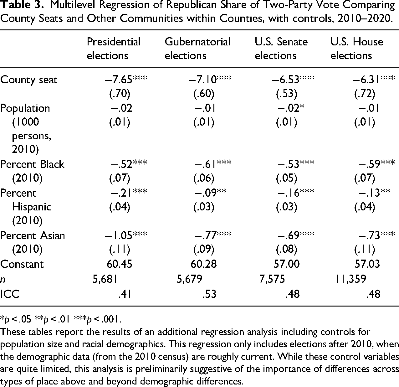
Multilevel Regression of Republican Share of Two-Party Vote Comparing County Seats and Other Communities within Counties, with controls, 2010–2020.
*p < .05 **p < .01 ***p < .001.
These tables report the results of an additional regression analysis including controls for population size and racial demographics. This regression only includes elections after 2010, when the demographic data (from the 2010 census) are roughly current. While these control variables are quite limited, this analysis is preliminarily suggestive of the importance of differences across types of place above and beyond demographic differences.
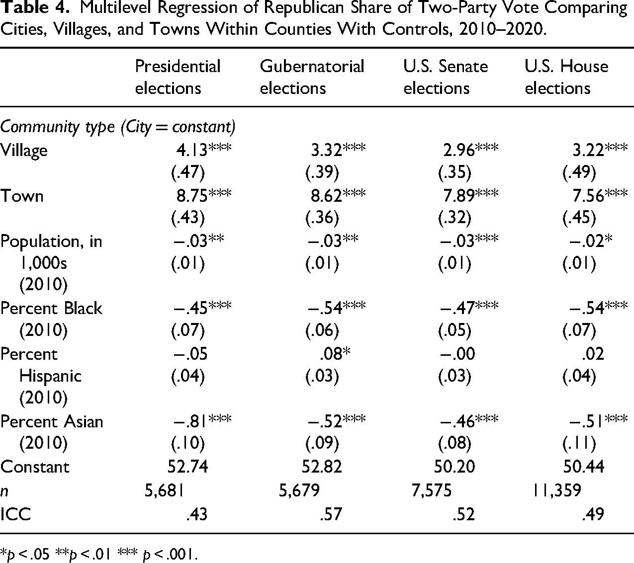
Multilevel Regression of Republican Share of Two-Party Vote Comparing Cities, Villages, and Towns Within Counties With Controls, 2010–2020.
*p < .05 **p < .01 *** p < .001.
While political conflict between cities and their rural neighbors is not new, the consistent partisan valence of the geographic polarization found here is a more recent development. Just like today, in 1990, the Democratic candidate for Wisconsin Governor performed considerably better in the city of Racine than in surrounding communities. However, both Hudson and Adams-Friendship were actually more supportive of Republican Tommy Thompson than their rural neighbors. The same pattern would hold two years later in the 1992 Presidential Election. By 2020, Democrats would have a local advantage in all three cities.
Figure 3 plots the predicted Republican performance in the average county, comparing county seats and other communities for all four types of elections considered in this paper. Figure 4 plots the differences in Republican performance across cities, towns, and villages within the average county. In 1990 and 1992, Democratic candidates for Governor and President performed better in cities in just half of Wisconsin's counties. By 2018 and 2020, that was true nearly everywhere. Just as the divide has grown more consistent, it has grown larger nearly everywhere. In 1990 and 1992, Democratic performance in cities and towns was within 5 points of each other in 60% of Wisconsin counties; all but a handful of counties saw a divide within 10 points. By 2018 and 2020, cities and towns in fewer than half of Wisconsin's counties were within 10 points of each other; only one in nine saw a divide smaller than 5 points. As these figures show, this same pattern also appears in elections for the U.S. House and U.S. Senate.
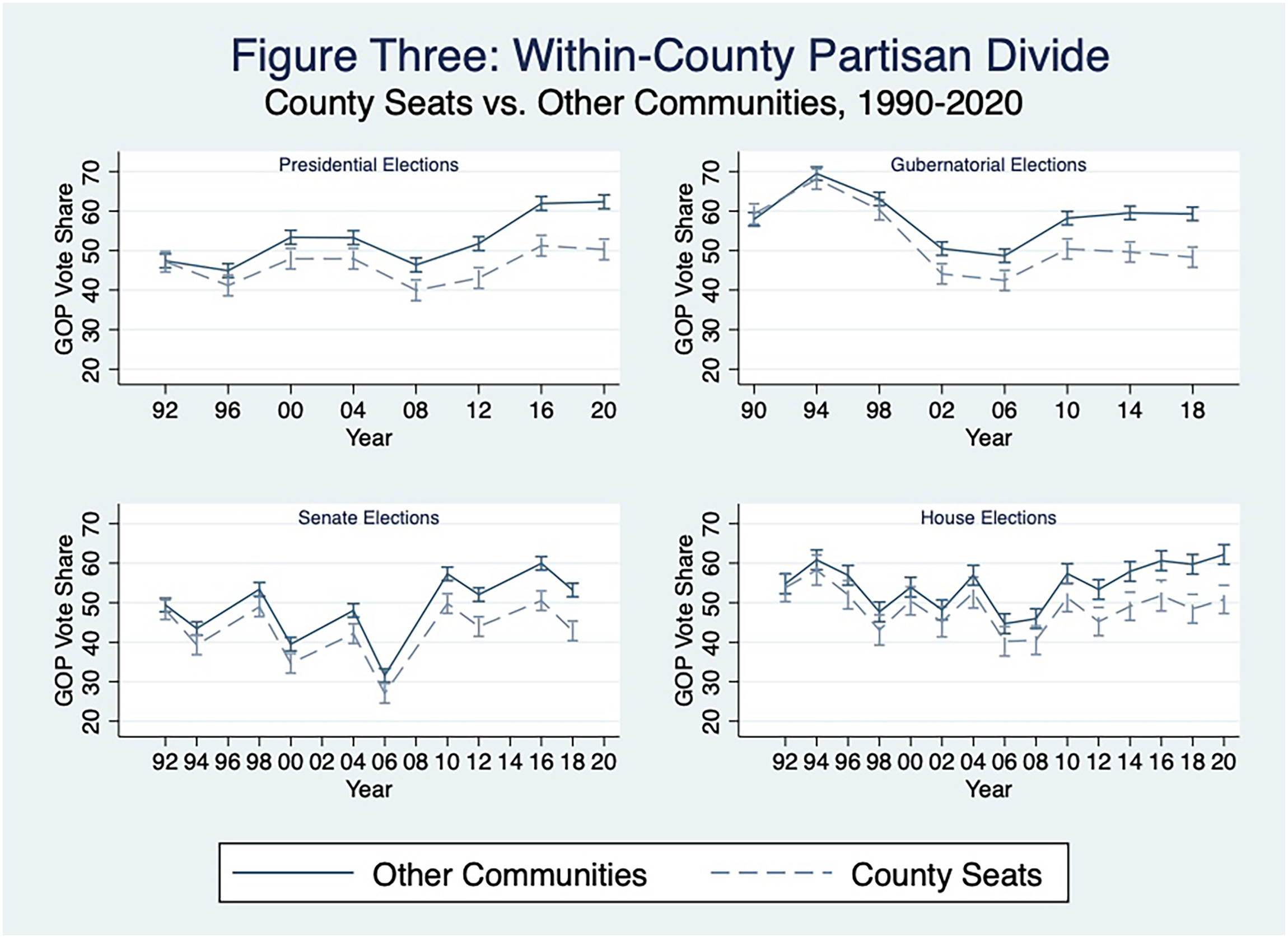
Within county partisan divide: county seats vs. Other Communities, 1990–2020.
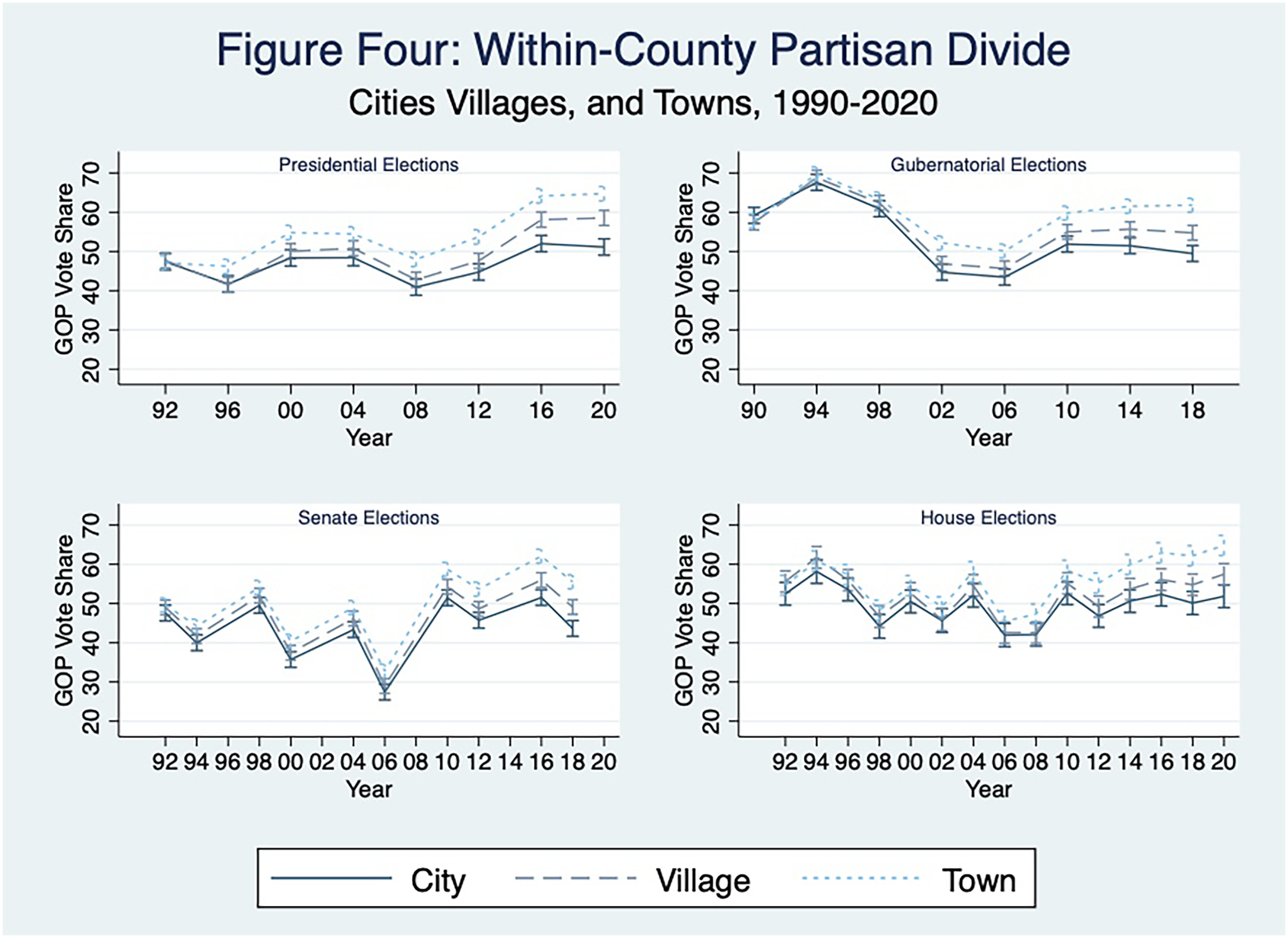
Within county partisan divide: cities, villages, and towns, 1990−2020.
There is a growing partisan divide between adjacent urban and rural communities. Geographic polarization, so often discussed at a regional and national level, must also be understood as a local phenomenon. Cities of every type, size, and region have become politically distant from their surrounding communities. Through an analysis of partisan changes in Wisconsin, this paper has shown that the local divide is not unique to any election, year, or place; rather, it has become a ubiquitous fact of political life. The exact shape of this divide may change in different contexts—for example, Wisconsin has few counties that are entirely urban and few unbroken chains of cities—but there is no reason to suspect that it is limited to this state.
The Relevance of the Local Divide for Urban Scholarship
Understanding the local divide is critical for the study of the problems, politics, and governance of U.S. cities. This is especially true as urban scholarship increasingly focuses attention on smaller cities that are much closer to the nexus of rural and urban. I focus here on three dynamics that illustrate the usefulness of the local divide to the study of urban politics: competing constituencies, policy islands, and conflict in regional institutions. I draw on examples from recent political conflicts in Wisconsin to illustrate these possibilities. These are only a fraction of the concerns posed to cities by the growing divide ripe for future research.
Perhaps more than other jurisdictions in U.S. political life, cities must confront the porousness of their borders. Hundreds, if not thousands, of people come and go from Wisconsin cities daily. City governments have always had to manage overlapping constituencies: residents, property owners, business owners, workers, and people who enjoy city services, infrastructure, and public accommodations. As partisan polarization between cities and their immediate rural neighbors grows more intense, so does the challenge of managing the competing interests of these constituencies. There may have always been conflict between city residents and people who commute to the city for work or leisure, but today, that conflict can take on a distinctly partisan flavor.
Two recent examples from small cities in Wisconsin highlight this potential. In Fond du Lac, the city council considered a nonbinding proclamation in support of LGBTQ Pride month in June 2020. 5 Eighty people spoke at a city council meeting on the issue; just under half were from far more Republican communities outside of the city. A majority of city residents who spoke that night supported the resolution, and nearly 70% of outsiders opposed it. 6 In nearby Oshkosh, the city council held a public hearing on a local mask mandate during the COVID-19 pandemic. 7 Nearly fifty people spoke on the issue, almost all in opposition. One out of three speakers was not residents of Oshkosh. They were residents of much more conservative rural communities who stressed that they used the city for work, shopping, and leisure. 8 In both cases, city council members struggled over how much to balance the opinions of local residents and outsiders.
A second challenge cities confront is potential policy conflict with their immediate neighbors. Cities and nearby rural communities are deeply dependent on the cooperation and policy decisions of neighboring communities. As adjacent rural and urban communities grow more politically distinct, they may adopt conflicting policies to address community needs. Of course, political conflict between cities and their neighbors is nothing new. However, this conflict's partisan, nationalized nature may present a more novel challenge. Cities risk becoming isolated islands, surrounded by communities whose contrasting choices undermine their policies’ effectiveness.
Again, municipal responses in Wisconsin to the COVID-19 Pandemic provide an illustrative example. Several cities—spanning regional, population, and partisanship characteristics—confronted the challenge of mitigating COVID-19 spread without the help of their neighbors. In Waukesha, city council members worried about the efficacy of placing restrictions on businesses when those just across the street, beyond city limits, could operate as usual. 9 In Wausau, they worried that sports leagues and other community groups would leave the city and begin operations in less restrictive communities nearby. 10 Many cities worried that they would lose businesses, cultural institutions, and residents to adjacent communities if they pursued contrasting COVID policies.
The transformation of political differences between cities and adjacent rural communities into partisan, nationalized conflict creates many opportunities for future research. What issues become the centers of political conflict between rural and urban areas? How do these issues interact with our broader partisan politics, and what role do partisan actors play in local conflicts? And how do these conflicts persist, evolve, and move from city to city?
Finally, although cities and their rural neighbors have grown more politically distant, they remain bound together in a number of local institutions. School districts, public utilities, county governments, law enforcement agencies, public health departments, legislative districts, and many more local political institutions stretch beyond municipal boundaries and serve adjacent rural and urban communities. How these institutions manage the competing partisan interests of cities and rural areas is ripe for future research.
For example, both Oshkosh and Wausau saw moments when cities had to bypass their county governments, which were hamstrung by partisan division. In Spring 2021, after realizing the county public health department did not have the political support for COVID mitigation policies, Oshkosh adopted its own mask mandate. 11 That same year, Wausau moved to create a city diversity committee after rural conservatives on the County Board stymied similar efforts. 12
Two recent elections for county law enforcement positions show how partisan tensions between rural and urban areas can shape local elections. In 2016, the Republican candidate for district attorney lost the city of Racine—with a large Black and Latinx population—by 22 points. However, she was able to secure victory by winning the county's smaller, much Whiter cities and rural areas by 33 points. 13 The 2022 race for county sheriff in Kenosha County, which followed a wave of local Black Lives Matter protests, tells much the same story. A Black candidate running on the Democratic ticket won the city of Kenosha—home to the county's significant Black and Latinx population and the site of the recent protests—by 5 points. However, his opponent, a White Republican running under the banner “Make Kenosha County Safe Again,” rode to victory on 30-point margins in the rest of the county.
The growing partisan divide between cities and their neighbors poses new challenges for urban governance and creates new opportunities for research. I have shown how cities must manage the competing political interests between residents and outsiders who may work, own property, or recreate in cities. I have demonstrated the challenges cities face when neighboring communities pursue contrasting policies and political strategies. I have discussed how the conflict between rural and urban areas can influence and impede local institutions that represent both. These are certainly only a fraction of the issues that the local divide presents in urban governance. Future research could provide a more fine-grained analysis of the issues presented here and explore additional challenges cities face in this political environment.
Conclusion
This research note has shown that the rural–urban divide may be closer and more intimate than typically understood. The fact that cities of all sizes, regions, and types are increasingly surrounded by politically distant neighbors has a profound effect on urban governance and local political life. This note demonstrated a relatively simple method for conceptualizing and measuring the rural–urban divide at the local level, deployed that method to show that local geographic polarization has grown dramatically in nearly every county in Wisconsin, and explored several important theoretical questions raised by this division. Political conflict and division have long defined the relationship between cities and their neighbors. What has changed in recent years is the consistent partisanship of this political divide across time, place, and political institutions. While the findings of this analysis—and the precise form of the model—are limited to Wisconsin, there is no reason to suspect that this local divide is unique to the state. Every state combines rural and urban communities—every state likely sees political conflict in the local institutions where the two meet. Future research can adapt the approach demonstrated here to examine how the local divide presents in other contexts.
This divide's magnitude, growth, and consistency suggest that it will be a critical feature of urban political life in years to come. Adjacent urban and rural communities—especially in smaller communities outside of major metropolitan areas—are profoundly interdependent. They must cooperate to facilitate development, manage infrastructure, and build thriving communities, cooperation made more difficult by this growing divide. This paper provides several examples of the problem the local divide presents to urban governance and politics, each of which could be the subject for future research. The growing rural–urban divide presents ample opportunity for urban scholars to examine how local institutions weather political conflict between adjacent communities. The evolution of rural–urban political differences into a persistent, partisan divide raises important questions about how the strategies and practices of local institutions must adapt and change to this new reality. But just as urban scholars have much to gain from the study of increasing geographic polarization, so too do they have much to offer. The local divide demands that we recognize the ways that proximity—not only distance—can drive political polarization and conflict. The political differences documented in this paper are between communities that are profoundly linked, where residents may move between rural and urban places daily and know (or think they know) the other side's world. We must more closely attend to the ways that closeness and interconnectedness can breed conflict, resentment, and polarization. This is a contribution that urban scholars—who have long studied divisions and conflicts within neighborhoods, communities, and cities—are uniquely prepared to make.
Footnotes
Acknowledgments
The author would like to thank Chaeyoon Lim, Mustafa Emirbayer, Richard Lachmann, Lew Friedland, Sadie Dempsey, and David Skalinder for providing incredibly helpful feedback on this paper. A version of this paper was presented at the American Sociological Association meeting in August 2021.
Declaration of Conflicting Interests
The author declared no potential conflicts of interest with respect to the research, authorship, and/or publication of this article.
Funding
The author received no financial support for the research, authorship, and/or publication of this article.