
Abstract
Tourist maps cannot be understood as signs or symbolic representations of an already constituted destination space. They are spatial devices playing an active role in the constitution of such space. To grasp this generative capacity, the author proposes conceiving tourist maps as diagrams, in the sense first introduced by Foucault and further developed by Deleuze and Guattari. Looking at very diverse tourist maps of Berlin and relying on selected spatial theory, this article examines four diagrammatic operations through which tourist maps constitute destination space: extending matter, edging experience, placing objects, and folding displacement. The article concludes by assessing the virtual ontological status of the space thus constituted.
Introduction
Tourist maps are central tourist devices, especially in urban locales, for planning day activities, finding the way to different sites, identifying major tourist attractions, and so on. Similar to dwellers’ mental maps, they help to avoid “the mishap of disorientation . . . and the sense of anxiety and even terror that accompanies it” (Lynch, 1960, p. 4). Tourist maps can be understood as bearers of tourists’ environmental images that, rather than being mental, are inscribed in durable and visible materials such as paper sheets, guidebooks, flyers, and brochures. As external material devices closely attached to tourists, these maps are also major tourist identity markers almost as ubiquitous as photo cameras. Their centrality in the articulation of tourist knowledge, practices, and spaces is probably the reason why they are produced and distributed by most stakeholders in the tourism industry, from tourism management organizations to restaurants and shopping malls, tour agencies, and hotels.
Despite the aforementioned reasons, tourist maps have been widely excluded in tourism studies. Del Casino and Hanna (2000) have observed that one contention, common in the geography of tourism, is that studying these maps is not really worthwhile “because of their blatant biases as advertisements and/or their flagrant disregard of the cartographic rule for accurately modelling reality” (p. 23). Another reason for their exclusion is that they are often considered to be mere representations, irrelevant for the analysis of tourists’ embodied performances of space and place. The few scholarly works on tourist maps, however, assess them as embodying complex relationships of space, identity, representation, and intertextuality. In the introduction to Mapping Tourism, Hanna and Del Casino (2003a) celebrate the wide range of topics that can be examined under the aegis of tourist maps: issues of representation, identity, memory, marketing, subjectivation, contestation, and so on. Tourist maps, they argue, are “not just” producers of space but above all artifacts entwined with the production and reproduction of social and cultural identities.
Certainly, very complex relationships of space, identity, and representation are inscribed and can be read in all main objects and devices of tourism such as maps, guidebooks, bus tours, or photography. Thereby, however, the specific qualities or performance of each of these devices—be they maps, guidebooks, or cameras—regarding their modes of “doing space” remain unnoticed. Indeed, while concentrating on the symbolic embeddedness of tourist maps, such approaches tend to pass over the question of their operation as producers of space and their character as a “quintessential spatial technology” (Brown & Perry, 2001, p. 30).
This suggests that the study of tourist maps has relied on an implicit distinction between space as a social and symbolic construction and space as extension. By focusing exclusively on identity, representational and symbolic construction issues, scholars concede that extension is a property of matter, this is, that tourist spaces are constructed upon prior and independent material extensions. This distinction has been thus structured in similar terms to those of gender/sex in classic gender studies and illness/disease in the first sociology of medicine. As Donna Haraway (1991) has shown, the concept of gender identity was formulated in the 1950s “within the framework of the biology/culture distinction, such that sex was related to biology (hormones, genes, nervous system, morphology) and gender was related to culture (psychology, sociology)” (p. 133). The problem with such distinction, argues Haraway, is that it leaves the construed character of sex and the continuity between bodily and cultural realities underexposed. More recently, Annemarie Mol (2002) made a similar argument regarding the unmarked category in sociological and anthropological studies of medicine, namely, disease. The distinction disease/illness was introduced in the 1950s by Talcott Parsons, as he proposed defining the object of medical sociology as illness, that is, the personal and cultural meanings attached to biological disease. Since then, argues Mol, social scientists could argue that “apart from being a physical reality, having a disease has a meaning for the patient in question” (Mol, 2002, p. 7), and even go a step further to point out that doctors have a cultural perspective on diseases and that medical knowledge is cultural. However, this cultural perspectivism still assumes disease to be a physical and biological reality inside the body and involves a political weakness, since “whatever one may say about ‘illness,’ as long as ‘disease’ is accepted as a natural category, and left unanalysed, those who talk in its name will always have the last word” (Mol, 2002, p. 22).
Consequently, the underlying distinction between space as social construction and space as physical extension does not simply reflect a difference in approaches to space, sociological and anthropological ones, on the one hand, Euclidean and geometrical approaches, on the other. What is at stake is not just two types of knowledge about space but rather an ontological distinction between the social and the physical, or more bluntly, between praxis and res extensa. Along the lines of this distinction, tourist scholars have accepted that the production of space through tourist maps does not involve or affect the geometrically stable material extensions of the world and overlooked the ways in which visual representations and tourist maps are involved in the production of spatial extension. Against this background, the main objective of this article is to investigate the most basic spatial operations performed by tourist maps through which destination space is constituted, beyond a distinction between the physical and the social.
To do this, I will first reconceptualize tourist maps as diagrams. Then, and relying on selected literature on space and exemplary tourist maps, I will distinguish and discuss four diagrammatic operations performed by tourist maps that are constitutive of destination space, namely, extending matter, edging experience, placing objects, and folding displacement. I will conclude by briefly summarizing the main points and emphasizing the virtual character of destination space thus constituted.
Maps as Diagrams of Destination Space
To understand the role played by tourist maps in the production of destination space, it becomes necessary to move beyond common understandings of maps as signs depicted in terms of a distinction between significant and signified or, more accurately for this case, map and territory. This is not to say that tourist maps cannot function as “indexes” representing a territory, since they are constantly used by tourists as route finders. Similarly, tourist maps can also be understood as “icons” of destination space, particularly as they are taken home as souvenirs or mementos. But the problem with these understandings of maps as indexes or icons is that they miss the generative and transformative capacities of tourist maps. In other words, tourist maps are not ex post operations of tourism, indexical or iconic representations of an already constituted tourist space, but they perform generative operations that produce tourist spatial extensions.
A suggestive alternative for this can be found in the concept of diagram. In A Thousand Plateus, Gilles Deleuze and Felix Guattari (2004) introduce this notion in the context of a broader discussion of four kinds of sign regimes that they called presignificant, significant, countersignificant, and postsignificant regimes. All these regimes, they observe, rely on a distinction, taken as a given, between a plane of expression (meaning, functions) and a plane of content (formed substance): “Expression then constitutes indexes, icons, or symbols that enter regimes or semiotic systems. Content then constitutes bodies, things, or objects, that enter physical systems, organisms, and organization” (Deleuze & Guattari, 2004, p. 158). It is precisely a distinction of this kind that underlies studies of tourist maps that focus on the construction of a textual-symbolic space (form of expression) but somehow assume that spatial extension (form of content) is ontologically given, not actively formed or transformed. In that context, Deleuze and Guattari’s notion of diagram is particularly helpful as it is oriented at understanding how forms of expression and content converge and constitute each other. Consequently, it is not simply that diagrams differ from indexes, icons, and symbols but rather that diagrams cannot be thought of in terms of sign regimes.
Diagrams are instead understood as generative machines producing reality forming and transforming expression and content. Deleuze and Guattari (2004) equate diagrams to abstract machines. With this notion, they aim at criticizing and expanding the linguists’ idea of a language-based abstract machine, which is limited to the form of expression:
A true abstract machine has no way of making a distinction within itself between a plane of expression and a plane of content . . . [It] is neither an infrastructure that is determining in the last instance nor a transcendental Idea that is determining in the supreme instance. Rather, it plays a piloting role. The diagrammatic or abstract machine does not function to represent, even something real, but rather constructs a real that is yet to come, a new type of reality. Thus . . . it does not stand outside history, but is instead always “prior to” history. (p. 142)
Use of the term history here necessitates a reference to the work of Foucault, from whom this understanding of diagram originates. Foucault (1977) introduced the concept when discussing Bentham’s plans for the Panopticon, which he described as the diagram of a disciplinary power mechanism, articulating delinquency as a form of expression with prisons as a form of content. Now, each of the diagrams described by Foucault, sovereign, disciplinary, and governmental diagrams, is treated in his work as “a map, a cartography that is coextensive with the whole social field” (Deleuze, 1988, p. 34). Deleuze though rightly questions this alleged uniqueness of the diagram for the whole social field, arguing that “there are as many [diagrams] as there are social fields in history” and that each of them “produces a new kind of reality” (1988, pp. 34-35).
These latter precisions introduced by Deleuze (1988) allow us to define a plausible theoretical starting point for the study of the diagrammatic function fulfilled by tourist maps. Certainly, tourist maps as diagrams are not coextensive or constitutive of “whole” destinations, but they can be productively understood as generative machines structuring destination space. In A Thousand Plateaus, Deleuze and Guattari (2004) speak of concrete assemblages to refer to the realities in which abstract machines are effectuated. In looking at tourist destinations as concrete assemblages, it becomes evident that tourist maps fulfill an important diagrammatic function simultaneously forming both its social and symbolic space, and its spatial extension.
One way of empirically approaching the diagrammatic operations inscribed in tourist maps is by focusing on the problem of visualicity. This notion does not simply refer to what is visible but, as Rob Shields (2004) argues, to the “logical and connotative system” on the basis of which urban space and representations of it are formed. As an abstract system, the notion of visualicity designates a type of diagram articulating the ways space becomes visible, graspable. The visible though is not to be equated with the material or the tangible. The principles of visualicity enable the visible to be intangible and the tangible invisible. Following this, the diagrammatic function inscribed in tourist maps and other visual devices can be empirically approached by looking at the operations through which these devices make destination space visible and graspable. In the following analysis, I describe and explain four diagrammatic operations inscribed in tourist maps of Berlin. The labels I use to describe these operations, “extending matter,” “edging experience,” “placing objects,” and “folding displacement,” are exemplified in the following sections with tourist maps of Berlin and articulated with some theoretical perspectives on space.
Overviews: Extending Matter
Cartography, observes Casey (2004), is the “effort to represent a given region of the earth . . . in accordance with the highest precision known at any given historical moment” (p. 260). Tourist maps depicting primarily the urban grid of a destination, such as the Berlin overview map of the guidebook Lonely Planet (see Figure 1), could certainly be interpreted in that way, that is, as cartographic representations of the city that have no impact on the space they claim to represent. Indeed, if the Lonely Planet map is compared with the tourist maps commonly analyzed in tourism studies, it is evident that this kind of map is of no interest to critical scholars, probably because they do not present enough material for interpreting the relationships between local and tourists identities, place myths, city marketing, and so on. The absence of this kind of map in such analyses is, in my view, highly problematic, because it leaves the impression that they are just cartographic representations not involved in the production of tourist space, as though caricatures, drawings, pictures, and tourist symbols were the only visual representations to take into account. I shall argue that it is precisely because this map does not say much about social and tourist identities that it is a particularly useful starting point for our investigation into maps as spatial devices or technologies.
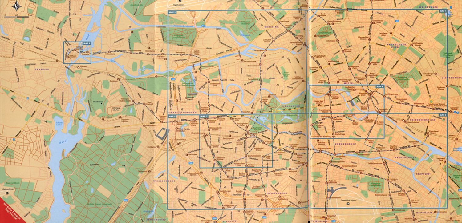
Berlin Overview.
The first feature that meets the eye is that the space of the destination is represented as a rather homogenous and nondifferentiated zone. It is important to note that neighborhoods are not differentiated by colors and that there are no visual overstatements indicating tourist attractions, facilities, or neighborhoods. The only urban elements highlighted by the map are some main avenues, green areas and Berlin’s underground, the U-Bahn, which is not abstractly represented, as in transport system maps, but embedded in the urban space. S-Bahn lines, that is, the overground system, are depicted but not highlighted. All these elements make clear that the map is not primarily a navigational device for users moving around within the city (as abstract transportation maps) or for situating themselves within the tourist geography of the city (as other tourist maps), but above all a diagram visualizing the city as extended matter, as a large physical extension.
The way this map is set in the page and relates to the limits of the page underscores the existence of a continuous physical space extending homogeneously over the whole world. In that context, any page limits or map borders involve arbitrary cuts in that absolute spatial extension. This is visually emphasized in that the map does not cover the whole city. While including almost the totality of the suburban zones sprawling toward the West of Berlin, at the right end of the map a sharp cut shows that the city extends farther east. Moreover, the map produces an extended physical space somehow indifferent to the tourist spatialities presented later on in the guide. No tourist attractions, tourist routes, or areas are highlighted, and what is more, the map excludes urban areas and attractions that are of interest for some tourists, such as the museums in South Zehlendorf, the zoo Tierpark to the East, and Schönefeld Airport to the southeast, while including a number of areas not usually visited by tourists. But extending matter in this indifferent manner is already a diagrammatic operation necessary for the constitution of tourist space. As Andrew Thacker (2002) has observed for cartographic maps in travel books, it allows producing “space as an undiscovered entity before the narrative commences, in order to justify the journey” (p. 14).
The Lonely Planet overview map also displays a basic spatial grid separating seven urban areas, which are presented in more detail in other maps in the guidebook. This grid also plays a central role in producing destination space as absolute physical extension. Indeed, by defining the limits of the other tourist maps of the guidebook, which do include tourist information, attractions, and even routes, it reinforces the notion that tourist space is constructed on an absolute space “out there.” Beyond this, the grid is presented as a cartographic device based on an abstract system of horizontal and vertical lines, which organize tourist space at two levels. On the first level, it demarcates four main areas. These areas are not centered in the map, but displaced to the right, and they fit major urban and tourist distinctions. The central horizontal boundary matches the West-East urban axis formed by the streets Birsmarckstrasse, Strasse des 17. Juni and Unter den Linden, whereas the vertical one roughly corresponds to administrative borders between urban districts. While relying on distinctions that are highly relevant for tourists, the grid insists on its cartographic gesture and structures destination space in four areas of the exact same size. On the second level, three further specific urban areas are demarcated. The two areas marked within the grid are particularly interesting, for they circumscribe two urban centers, which are also demarcated as having the same size, as though West and East Berlin’s centers were equivalent in size. Also here, the geometric pretensions contribute to visualize destination space as an absolute physical extension.
Bruno Latour (2009) has recently suggested that “res extensa . . . is an unfortunate confusion of the properties of geometrical forms on white paper with the ways material beings stand” (p. 142). Although by looking at tourist maps we cannot account for the ways tourist things really stand in the world, the analysis presented shows that the “unfortunate confusion” Latour speaks about is rather the result of a deliberate and accurate work of extending matter. Rather than accusing tourist maps of propagating confusion and deception—“Imagine that—the real world confused with a piece of paper!” (Latour, 2009, p. 142)—we should underscore the capital role played by this diagrammatic operation. Extending matter does not just enable producing space as an undiscovered entity, as Thacker suggested, but also, in a way, decompressing and expanding destination space. By visualizing the material extension of the destination, tourist maps counteract the possibility of a symbolic synechdoque of the tourist destination and render physical movement into a necessary condition to cover the material extensions making up destination space.
Tourist Areas: Edging Experience
In his phenomenological research into the space of place in human experience, Edward S. Casey (1998) radically questions the Kantian notion that experience and knowledge of the particular, of a place, for example, is preceded by experience and knowledge of space, the general. Interestingly, Casey does not just claim that in human experience place is general, “perhaps even universal” (p. 19), and the notion of absolute space only a particular derived from it. Casey (2008) also suggests that place should be understood as an event and that this involves, among other things, of course, dealing with the constitutive role of edges in human experience. Instants, for instance, which were understood by a long tradition of philosophers as the minimal units of experience, can be this “only within the edges of the events to which they belong” (p. 14). Casey (2008) observes thus that while the notion of instants, as it refers only to a temporal dimension, remains too abstract for understanding human experience, edges are constitutive of events, the spatiotemporal carriers of human experience.
These remarks are particularly helpful when looking at the diagrammatic operations performed by tourist maps, since besides extending matter, tourist maps play a major role in spatially edging tourist experiences. To grasp this, it might be helpful to distinguish first between borders and boundaries as Rob Shields does:
[T]he term border (from Portuguese and Spanish, via the Old French bordeure—“edge”) presently denotes territorial or material cases—at least in English, the word refers to a state border, the border of a diagram, a flowerbed planted along the edge of a property. In contrast, boundaries mark a border or edge. A marker stone (bourne), a line on a map, or even the result of an equation mark the “bounds” of an area. (Shields, 2006, p. 224)
Following Shields’s (2006) distinction, I shall suggest that tourist maps edge tourist experience by producing borders out of boundaries. Indeed, rather than signs, abstractions, or representations of borders, boundaries operate at a virtual level and therefore introduce real spatial distinctions. Again, Rob Shields has brought this right to the point:
The significance of a dotted line on a map is not its own inky materiality. It abstractly represents a border somewhere. But the history of colonialism is full of examples where lines drawn on maps were figured on the ground only much later. Such lines are more than representations or boundary-marking; they are virtual borders which prefigure concrete lines on the landscape. (Shields, 2006, p. 227)
Looking at tourist maps, it is quite easy to recognize the role these boundaries play in the demarcation of tourist areas. The latter have been mostly discussed in the literature in terms of “environmental bubbles” (Cohen, 1972), “tourist bubbles” (Judd, 1999), or “enclavic tourist spaces” (Edensor, 1998). All these notions describe spaces cut off from the local environments where they are located by means of material borders and security systems, spaces that tend to be associated with tourist “total institutions” such as cruise-ships, hotels, or resorts (Edensor, 1998). Even when urban tourist areas cannot be simply equated to enclaves materially cut off from the city by physical borders, this does not imply that urban areas are not subject to a process of tourist boundary drawing (Shields, 2006). Tourist areas are constantly fixed in maps and other visual materials, such as guidebooks, brochures, manual sketches made by locals, and certainly tourist maps.
Moving from borders to boundaries facilitates an acknowledgement of the role played by tourist maps in the production of tourist areas. One example of this, which can be found in the tourist map of Berlin included in the Wallpaper City Guide published by Phaidon in 2007 (see Figure 2), involves the segmentation of urban space in tourist consumption areas. This guidebook promises its rather sophisticated audience—the “design-conscious traveler”—“a real taste of the city’s landscape and the satisfaction that you’ve seen all that you should” (back cover). The map highlights some selected areas and emphasizes their inner homogeneity by coloring them. The city appears thus to be composed of a handful of neighborhoods, the pieces of an urban jigsaw puzzle. Coloring urban areas homogeneously situates the map in the visual tradition of political maps and evokes categorical and inflexible borders around the represented districts. But, interestingly, the map dismisses contemporary administrative divisions of Berlin. Indeed, in all cases excepting Schöneberg, the boundaries of the represented districts follow old administrative divisions. The map is complemented by short descriptions of the main social, ethnic, or architectural characteristics of the neighborhoods. Thus, Kreuzberg constitutes “the cultural melting pot of the city with plenty of places to eat and socialize,” Mitte is “the old city center, exciting new architecture and stylish boutiques,” Charlottenburg is “home of the main shopping drag plus a host of upmarket restaurants and hotels,” and so on.
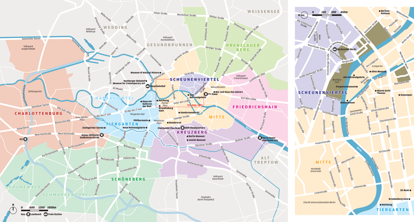
Berlin’s Tourist Areas.
The distinction of tourist areas involves spatially edging both local and tourist practices. On the one hand, boundaries delimit localities of urban practices, marking the spatial organization of dwellers’ urban experiences and practices. On the other hand, boundaries delimit localities of tourist practices—urban locales where tourists can develop a particular type of practice. In this latter sense, the generative character of tourist maps is associated with their capacity to transform “quantified space” into “qualified space” (Lefebvre, 1991). Through edging, maps qualify spaces as localities of urban practices available for certain tourist practices.
Beyond this, tourist maps of Berlin are particularly interesting, as they provide insights into the virtuality and inhabitability of borders. The Wall once separating East and West Berlin is still today a constitutive element of most visual representations of destination space. Such borders operate not just at a material tangible level. Their materiality might vanish, but borders can pursue a virtual existence, so that contemporary tourist maps show no major differences from maps dating from the beginning of the 1980s (see Figures 3 and 4). Since in both cases the border traced by the Wall is the main visual element organizing space, it is practically impossible to figure out which of the lines represents a physical border and which involves a virtual border.
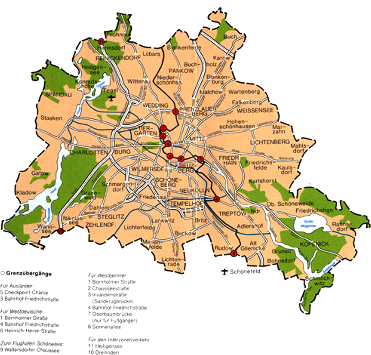
The Berlin Wall as Border.
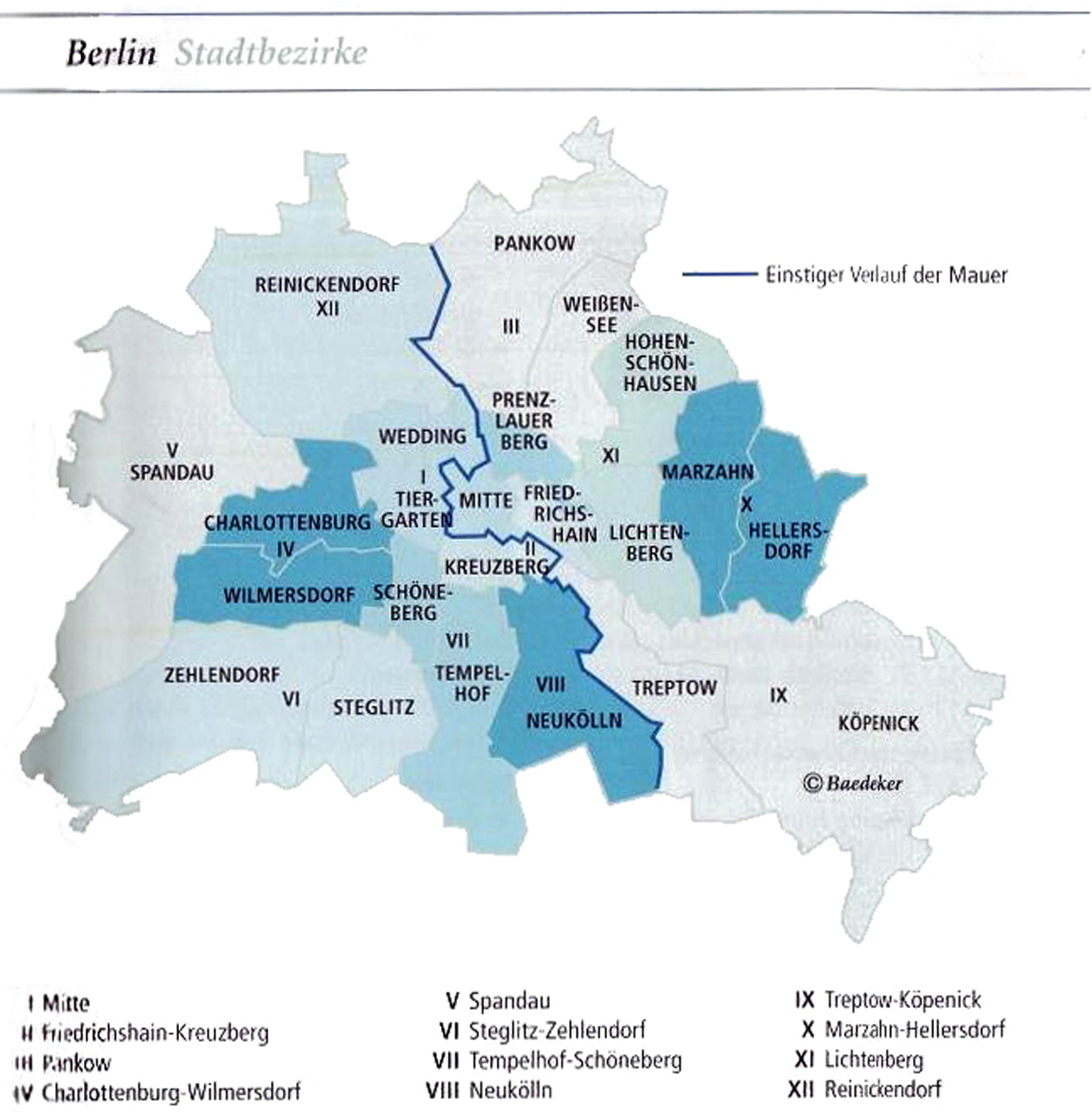
The Berlin Wall as Boundary.
Figure 3, however, adds a visual element that makes evident the materiality of the border. The red points over the border indicate crossing points, showing that the boundary relates to a material border. The Wall is thus presented as a crossable border by tourists—a border that separates two spaces, two worlds, and which introduces an either/or distinction. On the other hand, what makes Figure 4 particularly interesting is not just that the border represented is immaterial, virtual, and ultimately a product of the boundary inscribed in the tourist map but also that it forms that border as an interstice, which is not primarily to be crossed, but to be inhabited, traveled along, experienced. Here edging itself becomes the tourist experience, not just its condition.
Tourist Attractions: Placing Objects
Yet another perspective that aims at deriving space from place, and not the other way around, has been proposed by Niklas Luhmann (2000) in a rather short passage of his book Art as a Social System. Luhmann, as Casey, underscores the priority of place, but instead of emphasizing the constitutive role of edges, he elaborates on how objects produce places and thereby space: “[t]he ability to identify places independently of the objects that occupy these places generates space and time” (Luhmann, 2000, p. 111). Luhmann’s analysis is particularly interesting, as it proposes thinking of space not simply as opposed to place but as a result of the difference between object and place. Places constitute positions that can be occupied by only one object at a time. But even though they are constituted by the occupation of an object, places can become autonomous, at least temporarily, from the objects and their identities, so that a place can be recognized as such even after the object occupying it is displaced. For Luhmann, it is precisely this difference between object and place what generates space.
This approach involves looking at the ways objects are placed by tourist maps and the places and spaces produced through that operation. This involves a major change of perspective that should not be underrated. Indeed, as Martina Löw (2002) has observed, “apart from Luhmann, all [authors] seek to understand space as a relational arrangement. But nobody assumes that both people and things need to be arranged” (p. 150, author’s translation). Löw points out though that Luhmann only considered the placing of individual objects (Einzeldinge), thereby overlooking relationships between multiple objects (be they objects or people). Her proposal is to focus on the spatial “arrangements” of sets of objects, thereby distinguishing two operations: spacing, which is the process of placing multiple objects, and synthesizing, which involves transforming these collections of objects into integrated sets. Both operations are indeed central to understanding how tourist maps produce space, especially through the arrangement of tourist attractions.
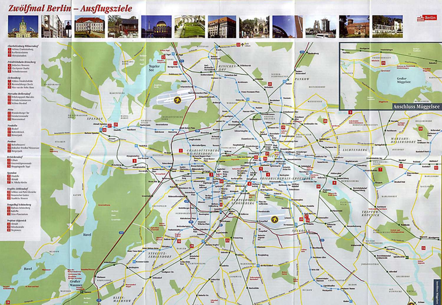
Tourist maps indeed exhibit high degrees of freedom for the elaboration tourist geographies through the placing of attractions. In extreme cases, maps claim to represent destination space only by placing a rather small number of objects (see Figure 5). In other cases, by placing only a certain type of attractions, tourist maps can render the urban space into a different kind of space, a natural landscape for example (see Figure 6). It is not that the latter map does not cover a larger metropolitan and therefore suburban area than the Lonely Planet’s overview map (Figure 1). The transformation it brings along relies rather on the way the map’s background is represented and especially on how attractions are placed. Indeed, despite being mostly concentrated in the center of the city, attractions are sufficiently widespread on the map so as not to suggest the existence of a dense city center. And their individual photographic portrayal is crucial, since it detaches them from their urban environment.
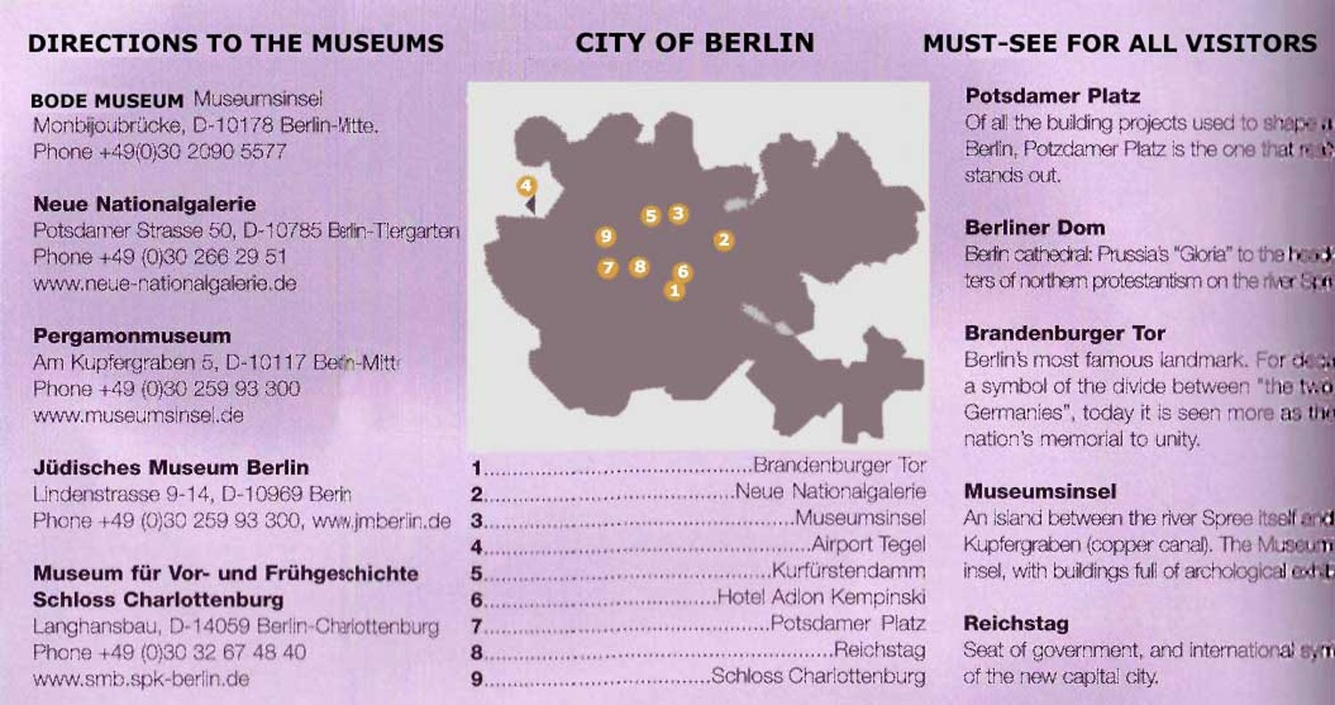
Berlin’s Attractions.
Berlin’s.
But tourist maps do not just distribute objects in places. Objects also need to be grouped or synthesized into larger sets for space to emerge. And while some maps arrange broad sets of tourist objects appealing to the general public, others introduce more specific and complicated arrangements. Figure 6, for example, establishes 12 distinct groupings of three attractions each, thus reflecting the administrative division of Berlin and suggesting that each city district has equally much to offer. A closer look at the maps above also reveals the central role played by textual indications in the grouping of tourist objects. Figure 5, for example, despite its apparent simplicity, depicts a rather complicated grouping of tourist objects. A first set of objects called “City of Berlin” groups destination space by means of nine tourist attractions. The right column of text brings together five of these into the subset “Must-see for all visitors.” Another column establishes a different set of objects under the heading “Directions to the Museums,” which are not depicted on the map but spatially integrated by means of a set of addresses.
The central question, however, is whether there are particular forms of arranging tourist objects characteristic of the destination Berlin. Probably the most salient and distinctive way of mapping Berlin in recent years has consisted of highlighting urban and architectural transformations—new buildings, building sites, and planned buildings—of this “always-becoming” city (see Farías, 2007). This was first noted by Karen Till (2003) for whom maps, models of the city, and virtual-reality simulations have been central for communicating the visions of the future of planners, architects, city boosters, and, particularly, of the public–private partnership for city marketing. Looking at the maps, brochures, and tours of the marketing campaign Schaustelle Berlin, she argues that these visual devices “detach buildings, ruins, and sites from their dense, multiple historical urban contexts and relocate them as showcases, or objects of tourist fascination to be viewed in particular ways” (Till, 2003, p. 63). Objects are thus arranged within a new spatial frame, “The New Berlin,” providing “a kind of ‘reality effect’ for these new mappings of the city” (Till, 2003, p. 63). Till’s analysis of maps of “The New Berlin” suggests an important shift over the years. The first maps of 1996/1997 were almost exclusively dedicated to the marketing campaign Schaustelle Berlin, highlighting with bold colors the objects indicated on the map. The map of 2000, she observes, was easier to read and of a more general nature, including transportation stops and names of streets. It highlighted buildings with rather pale colors not dramatically different from the colors of the background. She interprets such differences as oriented to communicate “to the reader/tourist that Berlin was undergoing rapid change but had ‘settled’ by 2000” (Till, 2003, p. 66). The arrangement of tourist objects produces thus a type of space that is not simply symbolic but which also involves the ways the physical space of the destination is formed and articulated.
Tourist Routes: Folding Displacement
A further perspective that is crucial to understand the way tourist maps work as diagrams of destination space has been put forward by Michel Serres in his book Atlas. This book does not convey a sound theory of space production but rather involves an attempt to found a relational metaphysics on the grounds of some fundamental spatial operations. Serres complains about the primacy of two prepositions in modern thinking: “under” and “inside.” “Under” is indeed at the basis of a notion of an underlying absolute space, whereas “inside” has enabled the modern separation between an interior (of mind, culture) and the exterior, and grounded the notion of place as an interiority. Instead of space as “under” or place as “within,” Serres conceives place as already containing space within itself. In this context, place is understood neither as a human event demarcated by edges nor as a position constituted by objects, but as a fold (pli), a doubling that produces an inside but results from an operation on the outside. The fold makes it possible to pass from place to space and from space to place.
In Horla, a short story by Guy de Maupassant, Serres finds the key notion to think about the fold and about this continuity between place and space. The Horla, which is the name for the invisible and malicious being haunting the main character of the story, combines the preposition hors (away from, out of) and the adverb là (there):
Hors indicates what is exterior and distant, while là designates the near. The Horla describes a tension between what is adjacent, neighbouring and contiguous and what is far, reachable or unreachable, starting from this closeness. Is there a contradiction opposing this hors to this là or, quite the contrary, is there a movement or a bond that unites them? (Serres, 1995, p. 64, author’s translation)
Instead of être-là, the phenomenological notion of human existence as Dasein, Serres proposes thinking of existence not in terms of a verb but of an adverb: hors-là, out-of-there. Rather than inhabitation, existence then involves displacement, resulting from being “both there and away simultaneously” (Boisvert, 1996, p. 67). Place does not emerge through an edging but rather through a displacement, from the inside to the outside, the near to the far, the closed to the open, the there to the away. Place then involves not just a folded space, but above all a folded displacement.
Tourist maps are central devices folding tourist displacements between here and there, one attraction and the next, and thereby constituting a tourist geography of contained movement. In tourism studies, there is a central strand of research on how space is experienced, practiced, and constituted in specific tourist mobilities (see Edensor, 1998; Farías, 2010; Haldrup, 2004; Larsen, 2001; Sheller & Urry, 2004). But although this literature tends to focus more on actual movement, on space as process, tourist maps confront us with space as a folded displacement or contained movement or, put differently, with a simultaneity of there and away, near and far, inside and outside. This folding of displacement occurs through a visual operation, which is very common in tourist maps, namely, the tracing of tourist routes. When actually followed by tourists, these routes might be studied as a particular form of tourist urban mobility. In maps though, routes might be understood as a diagrammatic operation constituting destination space by folding displacement. In what follows, I shall briefly describe two ways in which tourist routes fold displacement.
Tourist maps are often structured and organized around routes. These routes, however, are not vectorial trajectories prescribing unidirectional movement through a continuous space. As Figure 7 shows, routes in tourist maps emerge through the intertwining of multiple places. The space of the route is consequently discontinuous. Its discontinuity though should not be thought of as resulting from the irruptions and interruptions of places within a continuous space but rather as the containment of the complete space of the route in each of the places indicated. Along the route, places are not defined by edges or by certain objects but as stations, places to go through and traverse. Each place—or station—is interwoven with others places in the route and its position is relationally defined. Thus, through the intertwining of places, the route on the map brings along what can be considered the most minimal form of displacement, displacement without physical movement. The route brings along these tourist displacements in a folded manner, somehow folding and packing destination space for tourists to unfold it in actual practices.
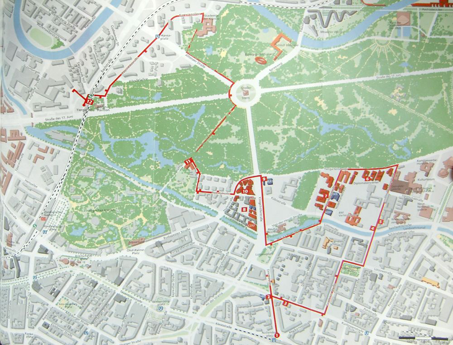
The New Embassies Route.
A further way in which tourist routes constitute destination space has to do with the relation they establish between the space of the route and the urban space surrounding it. A route is thus not just defined by the folded displacements it contains within itself but also in terms of its relationship with a constitutive surrounding outside. The hors-là constituting space operates in this sense not just for each of the places intertwined by the route but also between the route (là) and its surroundings (hors). A tourist area is thus constituted as a result of this tension between the inside and the outside of the route. These areas though are not defined by boundaries but rather by the folded nature of the route. The route is not an edge but a ridge. The route, as a mountain ridge, creates a gradient space to both its sides. The limits of such space are certainly blurred, but it is still clearly defined by the route crossing it.
Hence, the diagrammatic approach offers a unique perspective on the spatial operations of routes in tourist maps. Instead of a thwarted and incomplete form of movement, routes in tourist maps entail a double folding of space. On the one hand, the route entails a folding of intertwined places bringing along a form of displacement without movement. On the other hand, the route folds the space surrounding it to operate as a ridge constituting a broader tourist area.
The Virtual Character of Tourist Diagrams
The basic claim of this article is that tourist maps cannot simply be understood as signs or symbolic representations of an already constituted destination space but that tourist maps are spatial devices playing an active role in the constitution of such space. To grasp this generative capacity, I have proposed conceiving tourist maps as diagrams, in the sense first introduced by Foucault and further developed by Deleuze and Guattari (2004). Diagrams designate abstract operating principles informing the real in its material and symbolic dimensions and therefore giving form to both substance and expression. Correspondingly, the main aim of this article has been to identify, describe, and analyze the fundamental diagrammatic operations tourist maps perform. Extending matter, edging experience, placing objects, and folding displacement constitute central diagrammatic operations by which tourist maps form destination space. Each of these operations were presented and analyzed separately and by means of exemplary cases, although it should be stressed that most tourist maps combine multiple diagrammatic operations. To conclude, I would like to briefly discuss the ontological status of these diagrams of destination space.
The claim that tourist maps produce destination space might indeed be interpreted in two complementary but different ways by focusing either on their performation of destination space, or on the reality of their diagram. Focusing on performation would involve discussing the
process whereby socio-technical arrangements are enacted, to constitute so many ecological niches [such as a tourist destination] within and between which statements and models [such as tourist maps] circulate and are true or at least enjoy a high degree of verisimilitude. (Callon, 2006, p. 25)
Such an approach would address the complex historical process of actualization of diagrams and would entail analyzing how actors-networks partly constituted by tourist maps perform destination space, thereby identifying the specific contribution of the maps to their collective action, as well as taking into account “performation struggles” (Callon, 2006). In this article, I have followed a different, perhaps complementary strategy. Following Deleuze’s (2004) suggestion, I haven’t just avoided “giving [these diagrammatic operations] an actuality which they don’t have [but also, and this is crucial, avoided] withdrawing from them a reality which they have” (p. 260). Thus, I have understood the spatial diagrams of tourist maps as producing a real, but virtual destination space.
We can grasp this virtuality, first, in negative terms by looking back at Latour’s (2009) complaint that the notion of res extensa is an idealistic projection. Since in his work there is (almost) no space for the virtual (Harman, 2009), the ideal is equated with idealism. Hence, (tourist) maps projecting an absolute space would produce an idealistic confusion. However, the diagrammatic operations of tourist maps produce more than confusion. They constitute a real space, even when not actual or actualized. Thus, we approach the definition of the virtual taken by Deleuze (2004) from Marcel Proust as that which is “real without being actual, ideal without being abstract.” The same can be said of the diagrammatic operations visualized in tourist maps: these “are neither material nor are they simply abstractions (as in the case of representations of data). They are better understood as virtual—idealizations but not abstractions; real but not accurate visions of an actually-existing object” (Shields, 2004, p. 26).
It is perhaps through Peirce that we can better grasp the most decisive feature of the virtual space produced by tourist maps. Interestingly, Peirce (1906) introduced the notion of diagram by giving the example of campaign maps used in wars and discussing the answer a general might give to the question, “Why should you use maps when the country they represent is ‘right there’?” The general’s answer, says Peirce, would surely be that he might want to stick pins into the maps in order to mark the movements of both armies and work out possible scenarios. This experimentation with diagrams is possible, argues Peirce, because campaign maps contain and convey structural relationships constituting their object. Diagrams are not concerned with external appearance but rather with the constitutive structural relationships among the parts of the object at stake. Peirce then equates the general’s work on his campaign maps with experiments in chemistry oriented to figure out the molecular structure of a given substance. Neither the maps nor the chemical samples are the actual object of investigation and thought. Indeed, both might be thrown away right after use, because the structural relations they reveal are not attached to their actual materiality.
Peirce’s emphasis on the structural quality of diagrams resonates with Deleuze’s understanding of the virtual. Deleuze defines the virtual as consisting of differential elements and relations that form a structure and describes this virtual structure as exerting a “complete determination” of the object. The first part of this definition implies that the diagrammatic operations described above, and the destination space thus constituted, should therefore be understood as structural not actual. In other words, what tourist maps provide are the structures of destination space. The second part of the definition, which implies the “complete determination” exerted by tourist maps, should be very carefully considered. Deleuze equates the determination of the virtual with the determination a problem exerts on solutions. The virtual destination space brought along by maps thus has the reality of a generative problem and exerts a similar kind of determination, complete, not whole. Deleuze makes use here of a useful distinction between the completeness and wholeness of an object: “What is complete, he explains, is only the ideal part of the object . . . but never constitutes an integral whole as such. What the complete determination lacks is the whole set of relations belonging to actual existence” (Deleuze, 2004, p. 261). In this sense, and as we have seen earlier, the diagrammatic operations of tourist maps involve the complete space of the destination, the structural relationships between its different parts but at the same time no more than that. The destination as a whole depends rather on a process of actualization through performation, which has not been studied here and which involves actual states of affairs and lived experience. In their actual occurrence though, such states of affairs and lived experience take place on the ontological ground defined by the complete destination space constituted by diagrammatic operations brought along by tourist maps.
Footnotes
The author(s) declared no conflicts of interest with respect to the authorship and/or publication of this article.
This research was funded by the Transatlantic Graduate Research Program “Berlin - New York” (2005-2007) of the German Research Foundation.