
Abstract
This article uses ‘the journey’ – the act of traversing a physical landscape – as a means of understanding the role landscape can play in preserving and reinforcing societies and their activities. It is based on material recorded over the course of three field seasons between 2006 and 2014 in the landscape of the Karavas basin in the northern part of Kythera, an island off the southern tip of the Greek Peloponnese. This material consists of spatial records of the location and the character of gardens, water channels, mills and other features in addition to accounts and reminiscences of inhabitants that relate to the former and current use of the landscape and their social, cultural and spiritual relationships to it.
In this article, the journey is used to reconstruct a cultural landscape, a dynamic and self-sustaining amalgam of cultural, social and physical mechanisms and features. In this reconstruction, observed relationships between the inhabitants and their infrastructure form the basis for two interpretive approaches. The first considers the landscape and community as a unity, within which the character of the one is dependent on and reflects the character of the other. The second approaches the community as an interlocking and self-sustaining collection of cognitive and behavioural mechanisms. In this exploratory reconstruction, these two approaches are regarded as complementary, each compensating for conceptual and logical shortcomings of the other. The essential link between these two approaches is the landscape and its multiple meanings, in one sense a world defined, moulded and mediated by the task; in another, a structure of culturally mediated mechanisms. The author argues that both post-structural and structural interpretations generate valid and complementary understandings.
Introduction
The heart of a community can be understood as a quality held within and being representative of the totality of its inhabitants, and a relationship between a community and the physical space it occupies. Approaches to understanding this heart are designed to conceptualize one or the other but not, in general, both. Each approach involves a distinct methodology with specific tools: the one appropriate to the internal world of the community, the other rendered structural in its analysis of physical qualities. Each approach, when followed to the exclusion of the other, can only define, and thus only interpret, one part of the interaction between how and where a community lives. The former, whether understanding culture in symbolic terms or as defined by its activities, tends towards assumptions of stability and continuity. The latter, by its reliance on geospatial analysis and computing, tends towards interpretations based on strictly processual terms. 1 Both do not readily approach dynamics within a community as qualities that affect its resilience, its coherence and its capacity to adapt to change.
This article adopts two complementary approaches, each admittedly with its own limitations. It first seeks to identify these dynamics through the device of the journey – an act that is part participatory in that it involves an act of progressive discovery in the course of traversing a landscape and a community, and that consciously places the observer on equal terms with the community and begins with the incontrovertible physical reality of the landscape itself. It then uses a more structural approach, informed by the former, to interpret these oppositions as dynamic attributes that regulate the community on a more fundamental level. This style of interpretation is intended to serve as an analytical tool capable of defining observed characteristics as dynamic qualities underlying social structures that, on a deeper level, contribute to its coherence and resilience in the face of the sweeping changes that have confronted it.
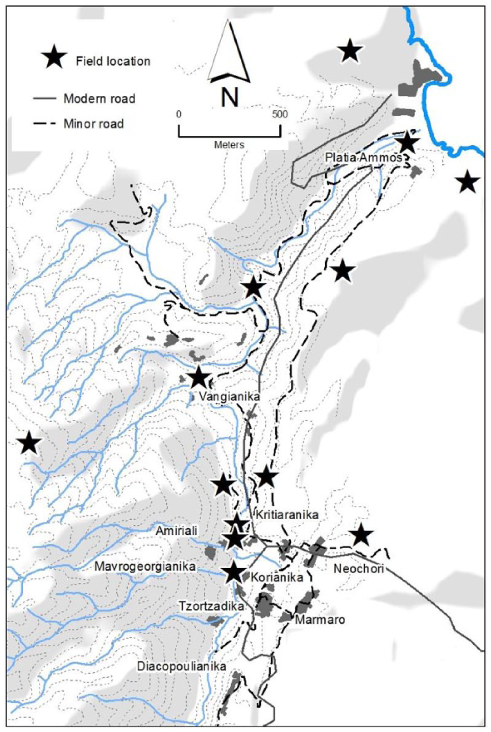
The basis for these two approaches is the work of the Karavas Water Project. Over a period between 2006 and 2014, the Karavas Water Project recorded the location of mills, water channels, gardens, house clusters and other infrastructure along the Karavas basin (Figure 1), that were associated with a communal way of life that existed in the northern part of the island of Kythera from the late 18th century, and continued unchanged until large-scale migration in the mid-20th century depopulated the region. Importantly, this region, like others across Greece, is the site of a new phenomenon of repopulation, in which activities that have continued in attenuated form are again taken up. While the economic circumstances of the population have changed, at a level fundamental to the heart of the community, its character remains whole and it is as a community with links to its past that it resurrects elements of its past. This resilience and cohesion suggest dynamics at work that extend beyond the activities themselves and the proclaimed identity of the population.
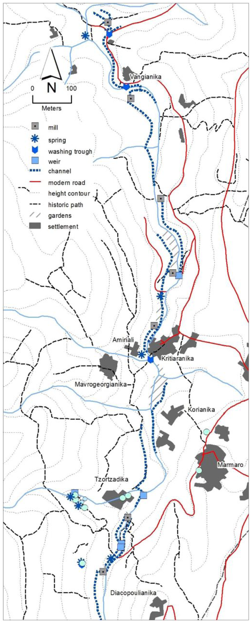
The Karavas basin, channels and related features.
Karavas, its locality and character
Roughly 30 km from north to south and some 280 km2 in area, the island of Kythera is situated a little over an hour’s journey by ferry from the southern tip of the Peloponnese. Diachronic surveys (Gregory and Tzortzopoulou-Gregory, 2015) demonstrate a continuity of habitation on the island spanning over 4000 years through to the current day. The north of the island of Kythera, including the Karavas region, is distinguished from the south of the island by a range of characteristics originating from a combination of historical and geographic qualities. These include distance from the seat of power in Chora, a common awareness of the northern location of the previous seat of power in Paliochora, the relatively late settlement of the area, and its inaccessible and rough terrain.
The Karavas basin extends from the ridges to the east of the town of Potamos near the village of Gerakari, past the scattered communities of Karavas and downstream to the village of Platia Ammos on the coast. The basin was intensively cultivated and the constantly flowing stream provided energy to drive water mills and to provide constant water to stream-side gardens. The infrastructure relating to the stream remains in active use and is regularly maintained by the community. This area was settled late in the 18th century by inhabitants of the town of Potamos who had themselves arrived only recently on the island. A review of family names (Kalligeros, 2012) suggests origins on the Mani and, to a lesser extent, Crete.
The communities of the Karavas basin are and have always been distinct, competitive and occasionally quarrelsome. Each community appears self-enclosed, even if only in name, since no apparent barriers exist between the community and any other. Yet, as a group, they function as a broader community with resilience and continuity that defeat the effects of time, migration, poverty and wealth, so that, together, they present a character that is somehow common to them all. As a community, they continue to maintain and use a highly efficient system of resource usage and production in the form of gardens (Πϵριβόλια) and water channels.
Two journeys through the Karavas basin
The stream running through the Karavas basin is fed by multiple springs along its length and the ridges to either side are at their closest only 150 metres from ridge top to ridge top. The stream runs through narrow, verdant strips of gardens, forest and reed-beds, and complex webs of terraces cover the steep northern slopes of the valley.
Three sets of routes span the length of this basin. The modern road runs between broad fields and terraces along the length of the southern ridge, descending to the sea to where the stream, dry in summer, meets the narrow coastal plain near Platia Ammos. An older road linking the communities of the basin descends from a point downhill from the Karavas town centre into the valley, following the southern side of the stream to where it crosses the modern road near the coastal plain. The mills and springs along the stream are most easily accessed by following the old foot and donkey paths following and crossing the course of the stream.
Each of these routes – the modern sealed road along the ridge, the older winding road beside the stream and the paths along the stream – represents, at the most basic of interpretations, a different view of the Karavas basin. Leaving the modern road aside, to walk the stream and to follow the lower road is to encounter two apparently contrasting ways of viewing the physical, economic and cultural world of the Karavas basin (Figure 1).
In addition, each of these routes represents a contrasting set of features and characteristics offering insights into the workings of the communities along the basin. By understanding each route as a journey – an act of traversing a landscape to fulfil a specific set of purposes – we are able to gather and interpret impressions of the forces underlying these features and characteristics. This interpretation begins by traversing space as part of the process of delineating and interpreting those characteristics of the community that underlie its complexity, stability and robustness.
Walking down the stream from the spring and cluster of buildings called Amiriali means following pathways between ancient, green and shady plane trees and through groves of primeval horse-tails on the banks and in the bed of the stream. Alongside the descending trail are series of gardens, some still farmed but many abandoned, linked by the cement-lined courses of water channels stemming from the stream and following the contours of the lower slopes. As the stream and paths descend, the channels, following a constant elevation, seem to rise and disappear into the undergrowth above until the white stones of a mill chute appear and the channel, supported by a narrow base of rocks, directs water out from the slope to the chute and the near vertical drop to the horizontal mill wheel. Close by a mill or spring, old paths, sometimes still stepped and paved with carefully laid stones, descend from the steep slopes to the north and south to meet and cross the stream.
Only some 40 years ago, the world of the stream and its lower slopes was a world controlled by the constant presence of water. Water fed the chain of gardens along its bank. Water turned the mills that ground the wheat and barley. Water fed the communities along the basin. Water drew the scattered communities together into common tasks associated with extracting the means of life from the narrow fringe of fertile fields along the stream. Life here meant working within a substantially self-sufficient community that depended on its produce for its livelihood. In the days before the post-war economy reached Kythera, each family worked its fields in order to ensure its own survival, and yet this necessity, so apparently individual to each family, required collective action which ensured that the community, as a set of individual families, was able to survive.
Water, constantly flowing down the course of the stream, is directed to areas distinguished by the type of activity and by the community within which this activity is carried out. Each channel is associated with a number of features related to specific activities. These features include diversion points where water is led into specific gardens; washing troughs consisting of moulded mortar facings built into the edge of the channel or located alongside it, where the women of the community met and washed clothes; and mill races supported by narrow stone bases jutting out from the slope, directing water to a vertical chute dropping the water some 6 or 7 metres down to the mill wheel that powered the milling of the grain. This combination of features, each related to a specific activity, is repeated down the stream, as each new channel provides a new and independent source of water. Not every channel leads to a mill. Some channels lead solely to gardens and some pass through the mill and on towards another set of gardens. Some channels pass by or through washing troughs and some do not. Nevertheless, each channel both embodies specific activities and delimits them by the extent of its course. A community of water users is bound by the common source, even if distinctions within each community exist, defined by activity. Each channel both sustains and defines a community of users.
There is also a level at which water channels move between communities, requiring cooperation between these communities. Each year, around Easter time, the channels are cleaned and repaired. This involves considerable effort and requires the participation of all users. Throughout the year, the flow of water must be regulated to ensure that each of the gardens is watered and that the miller receives sufficient water to power the mill. Once again, stable communication down the length of the channel is essential. Further, while the locations of the multiple gardens are defined by the availability of water, the ownership of each garden is a separate matter, being a result of many generations of bequest, dowry and purchase, or acknowledged but contested ownership through use. So, while each garden owner may work within a community defined by water usage, he or she is also part of respective family and village communities and, as explained later, these two communities are not, for the most part, geographically the same. In this way, access for usage to each garden may involve traversing gardens belonging to other families. While it may be an understood right, it is nonetheless a matter of potential contention requiring explicit understandings. So the cohesive spirit of collective action is sustained by the need to agree on respective watering schedules, to cooperate to maintain, clear and use the channels, and to traverse the gardens of other unrelated users. Two distinct communities of users are then sustained by water. One is geographically defined by the presence of water, although not necessarily related by family or village, and the other, in the case of the washing troughs, is defined by that activity and, through geographic association, by family or village.
From the level of the stream, we get the impression of the Karavas basin as a cohesive community of individual families drawn together by common necessities and infrastructure. It is easy to idealize this cohesion and efficiency of resource usage and to advertise it as an alternative to modern resource usage, and indeed such a case can be made. However, the real case, the one that involves an understanding of the community itself, can only be made after another side of this community is traversed and discussed.
The lower road from Karavas passes through the outer clusters of communities forming the town of Karavas before descending towards the stream. It passes below Neochori, with Diacopoulianika, a self-consciously separate community, visible on its own ridge away to the left, and continues through the upper houses of Kritharianika, with Korianika further upstream. A narrow lane extends downhill to the left through Kritharianika and across the stream to Amiriali and its spring, with the ominous ruined houses of deserted Mavrogeorgianika clinging to the steep slopes above. Hidden by dense laurel and fig trees some 300 metres up the stream is the now abandoned cluster of houses called Tzortzadika.
Beyond Karavas, the road descends to the lower slopes of the valley and follows the stream past a succession of small, largely deserted clusters of buildings and the occasional renovated house, distinguished by whitewash and blue shutters. The settlement of Bangianika is distinguished by a rough sign visible virtually as you drive round the bend and leave the town. Past the town, a road leads to the left across the stream and into the hills by the area known as Krioneri, and further on, another road leads to the left towards the lighthouse, passing through a series of small house clusters in a broad valley. The lower road itself continues to follow the stream as it levels out and is hidden by broad reed-beds. The landscape uphill, dry, stark and segmented into olive and fruit-tree terraces above the road, now descends to meet the stream so that, when the road finally crosses it before joining the main ridge road, the land is marked by a flinty, dry, olive-coloured brightness and consists largely of variations of rocky outcrops, the occasional sight of a barren terrace and the bare rock of the road cutting. Any hint of greenery and flowing water is hidden by the broad reed-beds.
This world is one dominated by settlement and not by the water-driven industry of the stream. Industry is evident in the scattered olive trees on broad terraces uphill and the dense networks of dry terraces along the opposite side of the valley. This landscape tells another story. Firstly, the collective of settlements in Karavas are, for the most part, each denoted by a separate family name: the Tsortzis from Tzortadika, the Coroneos (also spelt as Koroneos) from Korianika, the Krithari from Kritharianika. This distinction, apparent across the island, essentially denotes clusters as the origin – the iadika – of a family, even if today multiple family names are found in each village. It is a distinction of the Karavas locality, not so much that so many settlements exist in such a close geographic relationship (the nearby town of Potamos has a similar number of localities), but that they are each geographically distinguished by an intervening space: a bridge, a group of terraces, or the slopes of a topographically distinct hilltop or ridge.
Social and economic elements underlying opposing characteristics in the observed landscape
These two journeys distinguish opposing sets of characteristics which, because they concern the same individuals and communities, can also be seen as complementary. They are opposing in that the uniting influence of the streams, springs, gardens and channels contrasts with the distinctions of family settlement evident along the ridge. Nevertheless, each opposition is long-standing and apparently stable. A range of distinctive historical characteristics within communities in northern Kythera and along the Karavas basin contributes to these oppositions and suggests a social counterpart to those spatial characteristics observed. This section sets out a number of key oppositions derived from observations that relate to spatial configurations of domestic and agricultural activities.
Nuclear family structure and distributed field ownership
Violetta Hionidou, in her 2011 analysis of 18th-century Kytherean family structure drawn from the Venetian census and legal archives (Hionidou, 2011), argues that family structure in Kythera during the 18th century is substantially nuclear, with multiple family households created on a temporary basis only following the marriage of a son. Her conclusion, based on notary records and census data, that economic ties were preserved between brothers and their families, and between the family of a succeeding generation and its parents, has a contemporary counterpart in current law regulating family land ownership. While her analysis is confined to 18th-century Kythera, changes to the local and regional economy between the last Venetian census in 1788 and the Second World War were largely incremental until the introduction of industrial resource production late in the 19th century, bringing a cycle of increasing economic expansion, increasing migration and monetization into Kythera. Until that time, it seems justifiable to view the Kytherean household as substantially unchanged in character across this period. This structure is reflected in the distinct house clusters accumulated through the generational establishment of households
While house clusters have grown as generations create independent households, through these successive generations ownership of land has been competitive and strategic, resulting in legal actions between and within families. One current land-owner was kind enough to show and describe all the fields owned by the household (Figure 2). The current distribution of these fields is a result of a combination of generational accumulation through dowry and bequest, and a recent, unusually cooperative agreement between siblings to re-distribute respective allocations.
Example of single household field distribution.
This land-owner owns gardens, fields and domestic land in some 13 separate locations, some garden beds in the valley and some open fields on or close to the ridges. In an agreement with his siblings, he exchanged vineyards and olive terraces for fields with other productive capabilities. Making specific, strategic decisions, he has ensured that his fields cover a range of products, thus ensuring some resilience in the face of lean years, and has selected fields consistent with his capability to farm them.
An important aspect of the distributed field system is the need for individuals to continue to make use of their fields. If for some reason a field is not used, it may be ‘squatted’ as an outsider establishes accrued ownership rights following a period of uncontested usage. One source noted this period as ‘three years’. 2 An outsider is able to extend his or her ownership in this way and so enter a locality. In the years following the mass migrations of the post-war years and the subsequent gradual re-settlement by retired immigrants and their children, the issue of the ownership of abandoned fields and asserting this ownership is becoming important. Nevertheless, the rights of an outsider to claim unused land ensured that land remained cultivated, either in the act of asserting continuing ownership or of supplanting it.
The individual land-owner has then also in the past farmed the land belonging to his brother and under agreement harvests the produce of other fields also belonging to other family members. So, as a result of bequest and dowry, conscious selection and a need to assert family ownership in the face of the legal right for a stranger to take up unused land, his land holdings are distributed over a large area (Figure 2) that he must traverse in order to continue farming. Farming these fields is then a process that demands decentralized activities.
That this pattern is representative across the region and elsewhere and, indeed, is part of a historic pattern is difficult to establish. The links between dowry, inheritance, field size and dispersion (see, for example, Forbes, 2000) and the effect of partible inheritance (property apportioned among heirs, see Bevan et al., 2013) have been noted. Davis (1991: 180) notes instances of the deliberate selection of field location and Whitelaw (1991: 454) suggests the role of dowries favouring the inheritance of the house along the female line in preserving the integrity of land holdings. Yet there are a number of aspects of land ownership and use in the Karavas basin that set it apart from areas treated in other studies. These include its separation from estates of the south of the island, controlled by the Venetian aristocratic elite and their representatives and specific attempts by administrations, notably the British resident in the 1830s, to foster the clearance and cultivation of land (Jameson, 1836). However, perhaps the most significant characteristic of the land and population of the Karavas basin in this regard is the relatively recent movement of its population into an area that was both fertile and uncultivated, fostered perhaps in part by the efforts of the British administration of the early 19th century.
Locally asserted independence and mediated intra-communal conflict
Many of the families in the Karavas and Potamos areas migrated from the Mani in the southern Peloponnese in the 17th and 18th century to escape Ottoman rule and unrest during periods of war and conquest (Kalligeros, 2012). Settling in Potamos and establishing family districts in that town that still remain, many then established a presence in what is now Karavas through purchase of or marriage into land. Since that time, the Karavas area has been said to have maintained a character of independence and entrepreneurship that is distinct from the rest of the island. One effect of this was an asserted sense of local individual and family-based individualism and egalitarianism, fostered also perhaps by a history of constitutional independence having its roots in the revolutionary spirit of the French administration (1797–1799) (see Leontsini, 2000: 248) and intensified in the Karavas area by the historical absence of the feudal system maintained by Venetian families in the southern part of Kythera (Leontsinis, 1987).
That this characteristic is not confined to the 18th century is evident in the interaction between Jurgen (George) Koksma and the communities of Gerekari, Karavas, Diacopoulianika and Prongi in the course of building a system of water access to the lower communities. In 1960, Jurgen (George) Koksma, a Dutch engineer, undertook engineering works in Kythera as part of a 10-year community development programme sponsored by the World Council of Churches. His diaries, describing his various experiences, were curated by Jean Bingen and are housed in the local library at Kondolianika. Koksma, in early negotiations with communities, received representations from Gerakari – incited possibly by a single individual – accusing other communities of attempting to steal water. At one point in the building of the system, it appeared that this in fact had occurred (Koksma, 2014).
The longevity of these rivalries and the extent to which they may serve to distinguish a community and exclude another can be seen in the construction of the modern church in the centre of Karavas, the selection of the site influenced by a dispute that originated in the late 1700s with the exclusion of family members from the Karavas community from an Easter Church service (Tzortzopoulou-Gregory, 2014, personal communication, July)
While the existence of distinct family-based house clusters and a history of egalitarianism and independence appear to be divisive and competitive qualities, evidence for considering that the interests of a broader community are still recognized exists in the form of a long-standing reliance on notaries for providing documentary evidence of rights to land and property. A significant proportion of the information available to researchers comes from these agreements, set down by notaries from the 16th century on. The role of notaries continues as a function of the modern Greek state. That the role of the notary is so central can be seen both as a sign of the inherent opportunistic capability of the individual in Kytherean society of the time to take advantage of an unclear or contestable arrangement, and as a long-standing recognition of a communal right to a broader law.
Interpreting observed characteristics as dynamic qualities
This section seeks to establish a relationship between the characteristics observed above, static in that they are restricted to observed patterns of behaviour and spatial distributions, and more fundamental dynamics providing structure and coherence to a community and serving as a key element in continuity of the cultural landscape. It is not enough for a pattern of efficient land use to exist. What is important is that it remains embedded in the community and survives social and economic perturbations.
The two journeys described above are subjective impressions gained through the act of traversing the landscape. They are, though, also a set of observed and recorded data. The physical landscape is the level of the most basic observable element, from which the impressions of the journey inherit a consistent level of objective data in the form of physical correspondences and characteristics.
The interpretation of these characteristics, integrating space and community, should not be seen as an explanation but more as progressive points of understanding that rely on an essential overlap between space as a culturally mediated physical entity and culture as an entity that can be interpreted in spatial terms. If, as Mitchell (2000: 63) asserts, culture ‘insinuates itself into our daily worlds as part of the spaces and spatial practices that define our lives’, then space becomes a medium for culture and is modified through cultural practice. Backhaus and Murungi (2002: 8) refer to places as ‘bounded locales imbued with social and cultural meaning’. Massey (2006: 6) defines the place as inherently contested: ‘in any even minimal recognition of the relational construction of space and of identity, “place” must be a site of negotiation, and often that will be conflictual negotiation.’
If, then, culture has a dominant spatial component within which it and the space it occupies are inherently contested qualities, culture itself can be seen as an act of negotiation, and the conclusions and observations reached in this article constitute ‘firmer ground’ from which to perceive and interpret, and to broaden the theatre of negotiation.
This interpretation of observed and researched characteristics in the community involves two processes. The first develops statements relating to the community from impressions prompted by elements in the landscape, making use of the tension between Ingold’s (1993) taskscape and patterns within the physical landscape. These statements seek to resolve apparent contradictions by referring to patterns in community behaviour mediated by the spatial location of physical infrastructure and gardens. The second considers mechanisms and structures that govern the behaviour, collective existence and cognitive awareness within a community that, together, contribute to a sense of ‘culture’. These structures can be seen as agents preserving coherence and resilience, yet also in a critical theorist sense as driving change (Fuchs and Hofkirchner, 2009).
Each approaches the idea of ‘culture’ in a different but, arguably, complementary way. The first considers culture in a dynamic sense in which the boundary between the observer and the world, and the understanding the observer has of this world, is negotiated in an act of understanding. This understanding of culture ‘insinuates itself into our daily worlds as part of the spaces and spatial practices that define our lives’ (Mitchell, 2000: 63). It is, as Cosgrove and Jackson (1987: 95) suggest, ‘the very medium through which change is experienced, contested and constituted’.
The second approach uses observed data to generate a set of propositions supported by historical and sociological references that comprehensively represent observations. These propositions, developed from dualities observed in the respective journeys, are reviewed in a hierarchy of contexts in an attempt to understand them as dynamics threading through the various elements of a community and constituting its ‘culture’, defined as a medium for transformation (Cosgrove and Jackson, 1987: 95) and as a ‘relationship’ between forces interacting in its ‘production’ and ‘use’ (Mitchell, 2000: xviii).
1. Interpretation as a journey into the ‘taskscape’
The natural extension to evidence presented as a set of personal impressions is to interpret in post-structural terms, acknowledging the validity of the personal perspective. The reflexive relationship between the landscape and the community requires a perspective that acknowledges the dynamics of change and how meaning is acquired and modified in a community. A valuable tool for interpreting these forces is Ingold’s (1993) taskscape.
Ingold’s article introducing the concept of the taskscape – The Temporality of the Landscape – appeared in 1993 at a time when the positivist approach inherent in a range of disciplines was being questioned. His discussion of the landscape did not just deal with its temporality, but involved defining a frame of reference through a reflexive critical approach to the relationships between the individuals and the physical features around them. He explains:
One of the great mistakes of recent anthropology … has been to insist upon a separation between the domains of technical and social activity, a separation that has blinded us to the fact that one of the outstanding features of human technical practices lies in their embeddedness in the current of sociality. It is to the entire ensemble of tasks, in their mutual interlocking, that I refer by the concept of taskscape. (p. 158)
Bender, quoted in Massey (2006: 14), considers a ‘spatial and temporal confinement’ causing an overemphasis of the human as a shortcoming in Ingold’s approach. Nevertheless, the approach, by stating a common level for interpreting what are essentially the human and topographic elements of a landscape, provides a rationale for modelling human activity in a way that effectively combines space and community. If the landscape is seen as a combination of cognitive and physical, for instance as ‘multifunctional’ (Naveh, 2001: 269), this ‘spatial and temporal confinement’ becomes the means in which a progressive revelation of meaning can be achieved through a grounded reflexive critical approach.
The specifically topographic context of the observations from which distinctions between cohesive and dispersive forces are drawn grounds the interpretation through the severe objectivity of this physical world, within which errors, mistranslations and misinterpretations are minimized by the incontrovertible physical characteristics of a feature. By introducing a cultural world through a journey within a physical landscape, observers are introduced into this world, from the outset acknowledged as outsiders, aware of the essential difference between them and the world they analyse and interpret. While it is possible to distinguish between the spatial contexts of agriculture and settlement, when we begin to understand them as taskscapes – arrays of related activities – the behaviour behind them is more closely linked.
The dispersion of the gardens along the stream is in a geographical sense a complex network of distinct areas linked by the common infrastructure associated with water channels. The distribution of the gardens does not conform to that of the villages and house clusters, yet the gardens are forced into union by the water channels that juxtapose them with common domestic activities associated with the washing troughs. With this juxtaposition, the channels bring into association garden and washing trough, allowing a pattern of movement that traverses divisions between settlements.
The spaces between the settlements and between the scattered ownership of gardens are undercut by the water channels that divide the community into duplicated areas of domestic activity, and represent collective routes and actions involving access through neighbouring gardens and seasonal maintenance. The structured harmony they represent can be likened to the warp and woof of a carpet. The distinct settlements are the warp, parallel threads brought into harmony, resilience and coherence through the structuring function of the woof – the channels and the communication they represent.
When this common infrastructure is interpreted in a dynamic sense as the foci and conduit of activities, a more complex picture emerges of contrasting characteristics and the competing forces underlying them. The coordination of access and water availability does not compete with the dispersion of settlement. Instead, it can be viewed as a complementary aspect of the patterns of dispersion evident in the settlements along the valley since the two are intimately associated as user and the means of use. The need to coordinate activities along the stream confronts the individualism and competition characterizing settlement.
2. Interpreting characteristics as dynamic qualities through metaphor
The tension between communities is a contemporary and historical reality that can be seen in the communities’ responses to Koksma’s introduction of water reticulation linking settlements. Historically, Leontsini (2000) and Hionidou (2011) have acknowledged the particular level of social independence in Kythera, mirrored in the local institutions. The reality of rivalry, competition and independence is evident in the behaviour of families and individuals to this day. Nevertheless, just as clearly, the expected physical effects of this behaviour and these characteristics, as may be seen in the towered and walled villages of the Mani (Wagstaff, 1965), are not apparent.
A range of discrete processes can be synthesized from this general survey of the community along the Karavas catchment (Table 1). These fall into two apparent contrasting categories which, when seen as aspects of a functioning community can also be regarded as essentially complementary.
Dispersive and cohesive behaviour indicators.
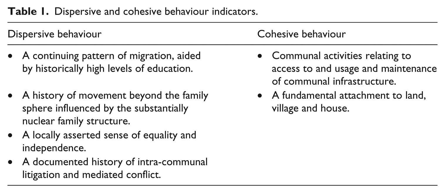
These cohesive and dispersive aspects of the community take the form of specific behaviour. If the above are two opposing sets of characteristics, do they acquire a dynamic nature as forces that reinforce social and cultural function, and to what extent can the interaction between these forces be seen as serving a role in the definition, coherence and resilience of this community? To investigate this further, we must invoke cultural and social concepts and metaphors that, while critical systems theory based in that they consider society in systemic terms and acknowledge the presence of ‘fundamental paradoxes, antagonisms and antinomies’ in society (Fischer-Lescano, 2012: 4), promote stability, longevity and resilience rather than assuming emancipation as an immanent resolution.
One metaphor capable of assessing the extent to which these opposing characteristics serve as forces is that of agonistic plurality. Proposed by Mouffe (2000b), the concept of agonistic plurality is founded on the interpretation of society as a compensating structure of interactions between individuals (Simmel, 1904). While, like Marx, Simmel understood society as a dynamic structure of competing forces, unlike Marx, Simmel regarded these forces as compensating interactions giving rise to and maintaining social structures and features. The role of conflict in society and politics is central to the concept of agonistic plurality, derived from the Greek ἀγών – contest. Agonism in a political context, for example Weber’s (1949[1917]: 26) ‘irreconcilable struggle’ suggests that the resolution of conflicts in society and the creation of a harmonious state are not possible but that the driving force in political consensus is the continuity of negotiation between conflicting parties founded on the ἀγών – the contest – as an arena (Mouffe, 2000a, 2000b; Crowder, 2006; Schaap, 2006). The suggestion that the continuous contest may constitute a source of strength and energy within a community is prefigured in Simmel’s (1971[1908]:144) discussion of economic exchange, trade and the relationship between the ‘stranger’ and the community.
Biedelman (1989), in applying the concept of agonism to Homeric exchange, echoing Simmel’s context of difference and exchange, extends the idea of agonism beyond the exclusively political and social into an area of exchange where it is magnified and enhanced by the Homeric context and enters a world capable of exemplifying sustaining social energy on a higher and more culturally tuned level common to the contemporary realm of Akritic epic. Conflict, contest and struggle are hallmarks of the Akritic repertoire, a folk tradition of epic poetry recounting the deeds of the heroic figure of Digenes Akritis. Digenes’ final deed, his virtual apotheosis, takes place on the threshing floor, upon which he wrestles Charos (Bryer, 2002; Livanos, 2011), symbolically linking the essential energy of regeneration and production with the eternal process of irreconcilable struggle.
While speculation on this level can provide no evidentiary link between conflicts involving cohesive and dispersive forces supporting and energizing a community, and basic observations of cohesive and dispersive behaviour, it is important to remember that the celebratory and metaphysical world of communities, including that of the Karavas basin, was one of music, song, remembered stories and a level of superstition generated and sustained within the community (Stewart, 2014). These provided another level of support, comfort and continuity and can be interpreted as the medium through which these conflicting forces gain life and power in the metaphors embodied in these songs, tales and beliefs.
Thus, these oppositions repeat in at least two fundamental community contexts, the socio-political and the mythic. The concept of the struggle extends from public politics into the history and the cultural expression of the community. The continuing dynamic of conflict in the community is sublimated into its broader character as ἀγών is expressed socially, politically and culturally. Examples of each of these three levels exist within the Karavas basin. Socially, the history of balanced plurality is evident in the ancient role of the notary. Politically, the constant negotiation necessary to maintain community structures is inherent in the conflicts observed by Koksma. Culturally, an awareness of the liminal exists within the community, focusing on those areas that enjoy no clear status of ownership – the water sources – at times not characterized by any specific activity – midday and dusk (Stewart, 2014). In these places and at these times, it would be too simple to say that the ‘other’ intrudes. Instead, this world of folk-tale, myth and belief, and the conflict inherent in it, become a part of the common community experience.
Conclusion
The cohesiveness, continuity and efficiency with which limited local resources are used are reinforced by the energy borne of the resolution of opposing forces. In this interplay between opposing forces, the balance continually adjusting in the face of seasonal activities, specific events and the actions of communities and individuals, ‘tradition’ as continuity is a balance that shifts within parameters set by the circumstances of the season, the character of the local community, technologies and methods of resource usage, and changes in the outside world. This shifting but continually renegotiated balance lends strength, durability and longevity to the material aspects of local resource usage that we consider so effective.
This discussion is an attempt to ‘read’ a community through two lenses. The first is through its interaction with characteristics of the landscape it inhabits. The second delineates and reviews characteristics that unite and disperse. Each approach is inherently limited. The first fails to ground essentially subjective insights into the behaviour of individuals and groups within an argument drawing on sources beyond the observed. The second acknowledges the physical world within which a balance of forces exists but does not include the more nuanced characteristics of individual and community within it. As complementary approaches, however, the limitation of each is compensated for by the approach of the other.
Because the topological elements of the landscape incorporate an essentially objective element that makes no a priori assumptions and exhibits minimal cultural bias, given that cultural bias is inevitable, the physical landscape serves as an objective datum for observations. A fundamental aspect of the landscape that this approach reveals is that of contrasting characteristics within a community that can be understood as contrasting driving forces.
By reviewing a community in the light of its place in the landscape and as a complex of forces, characteristics of the community are more closely associated with activity and behaviour, and the impressions of balance gained in the course of a journey acquire associations with concrete examples of balanced forces. Together, these perspectives go towards explaining the longevity and resilience of community and activity in the Karavas basin in the face of continuous change over the centuries. They also help to explain how the current community, fragmented and divided by recent large-scale migration, remains associated with the Karavas basin, why it is that use of the gardens and the fields never totally ceased, and why the presence of returned Kythereans in the substantially abandoned villages is now increasing.
Footnotes
Acknowledgements
My special thanks to Professor Tim Gregory and Dr Lita Tzortzopoulou-Gregory for their valuable assistance, generosity and inspiration.
Funding
The author(s) disclosed receipt of the following financial support for the research, authorship, and/ or publication of this article: This research received support from the Australian Archaeological Institute at Athens [2016 La Trobe University Research Scholarship].