
Abstract

Cultural Landscape is the result of human culture acting on the natural landscape, and it is a landscape created by both human and nature. 1 Settlement Cultural Landscape is a type of cultural landscape, which is the masterpiece created by human in the long-term life and production. It includes people’s learning of nature, exploiting of nature, production development and life creation. The masterpiece embodies the co-creation of man and nature. 2 The natural landforms and landscape patterns that constitute the cultural landscape of the settlement and the spatial structure, residential buildings, traditional culture of the settlement, all are significant features of locality. 3 Due to the economic and social development and rapid urbanization process, the locality of settlement cultural landscape is facing destruction or convergent evolution. Research on the locality preservation and cultural landscapes inheritance of settlement has been a hot topic that has long been a concern to academic scholars. In the context of the rapid development of information technology and its applications, the study of the information technology methods is necessary and imperative to develop locality preservation and to preserve our cultural landscape inheritance.
Thus, this article discusses the information technology methods for the locality preservation and discovery of inheritance of settlement cultural landscapes through three aspects: analysis of demand for locality preservation of settlement cultural landscape, analysis of information technology methods and their application characteristics, and technical system for the locality preservation of settlement cultural landscapes.
Analysis of the demand for locality preservation of the settlement cultural landscape
The local cognitive needs of the settlement cultural landscape
The locality of the settlement cultural landscape is reflected in its landscape components and landscape features. Investigation and feature identification should be conducted.4,5 The images acquired with remote sensing (RS) technology are helpful for understanding and grasping the spatial distribution and interrelationship of cultural landscape resources of settlements at a macro level. High-resolution RS images and global navigation satellite system (GNSS) positioning can also assist in detailed investigation and quantitative identification of landscape elements, 6 which any other technology is incomparable with.
Based on the investigation and identification of settlement cultural landscape locality by means of RS and GNSS technologies, with the help of geographic information system (GIS), the large amount of data obtained is organized and managed according to spatial information and attribute information, to form a comprehensive database of settlement cultural landscape. The database helps to carry out inquiries, retrieval, analysis and visual expression of settlement cultural landscape resources anytime and anywhere. Through multi-factor evaluation, the database can help to determine the locality of the settlement cultural landscape and its importance and sensitivity, 7 which can help to further carry out the preservation work.
Demand for preservation of settlement cultural landscape locality
On the basis of investigation and identification, the planning and management of locality preservation of settlement cultural landscape is effective. The planning process is essentially to classify, grade and evaluate the settlement cultural landscape of different districts, and formulate the preservation and management policy by the classification, grade and districts. 8 In the process of locality preservation and planning of settlement cultural landscape, multiple spatial information analysis based on GIS and settlement cultural landscape-integrated database, such as overlay analysis, buffer analysis, network analysis, etc., can all play a very good role. This can provide technology for multi-element quantitative comprehensive analysis in the process of settlement cultural landscape evaluation.9–11
In the process of preservation and management of settlement cultural landscape, the development of the settlement cultural landscape resource management information system based on GIS, such as the city information model (CIM) and the village information model (VIM), is a very good strategy to support city and village protection planning, supported by management information system and information model. Researchers can carry out routine query, retrieval, statistics, display and other management work. They can also carry out quantitative and qualitative analysis of variation and development forecast. At the same time, RS technology can be used to monitor changes in settlement cultural landscape resources, and timely adjust planning and management plans to ensure the preservation of the integrity and authenticity of the settlement cultural landscape.12,13
The demand for the preservation of local inheritance of the settlement cultural landscape
The fundamental purpose of preserving the locality of the cultural landscape of settlements is mainly in two aspects: one is scientific and reasonable utilization, and the other is continuous inheritance. Scientific and reasonable utilization is inseparable from planning and management. As a result, the application of information technology is obviously necessary. On the other hand, qualitative analysis with GIS can be applied in everywhere, every time, by every mean and to various extent. 14
The local inheritance of settlement cultural landscape involves two aspects: external and internal factors. The influence, penetration and erosion of foreign cultures are important external factors faced by the inheritance of settlement cultural landscapes locality. 15 The identity and pride of residents’ sense of their own cultural values are the fundamental internal factors of the inheritance of settlement cultural landscapes’ locality. 16 Based on the help of popular network GIS and management information system, the value and characteristics of the cultural landscape heritage of the settlement can be effectively promoted, which has attracted widespread concerns from all sectors of the society. The nurturing and educating the settlement residents is very meaningful, especially to young residents. If the whole society can consciously consider the value of the locality preservation and inheritance of the cultural landscape of settlements, the external influence factors would gradually reduce, and the internal protection awareness and responsibility of inheritance of residents would gradually enhance.
Analysis of information technology methods and their application characteristics
Information technology method is a general term for information technology that has been gradually developed and applied since the 1960s, which focuses on acquiring, managing, processing, analysing and expressing spatial information related to geographic location. It includes RS, GNSS, modern surveying and mapping technology, Internet of things (IOT) technology, big data technology, GIS, cloud computing technology, artificial intelligence (AI), virtual reality (VR), augmented reality (AR) and other technologies. 17 In summary, the application of information technology has the characteristics of objective and accurate information acquisition, flexible and intelligent information analysis, and intuitive and refined information expression, which is helpful to the study of locality preservation of settlement cultural landscapes.
Objective and accurate information acquisition
Using RS, GNSS, IOT and other information technologies, it is possible to objectively obtain accurate information about elements of settlement cultural landscape for locality. It includes static information of natural environment, buildings and structures, and socio-economic elements that constitutes the settlement cultural landscape. It also includes dynamic information such as people flow, vehicle flow, logistics, energy flow, etc. Combining static and dynamic parts, natural and humanistic parts, macro and micro parts together, researchers can comprehensively and systematically perceive and portray the locality of the settlement cultural landscape. It can also help to set up a technical foundation for quantitatively identifying its characteristics and its dynamic changes. 18 In recent years, with the launch of small satellites with high spatial resolution, high temporal resolution, high spectral resolution and high radiation resolution, as well as the development of unmanned aerial vehicle (UAV) remote sensing technology and its application, the application of RS technology has entered a new stage. Information technology is expected to play a greater role in the cognitive research on the acquisition of local information on settlement cultural landscapes, due to availability of BeiDou Navigation Satellite System (BDS), with its navigation system and its multi-modal application system, as well as the construction of the IOT system for smart cities and smart villages.
Flexible and intelligent information analysis
Due to the development and application of big data technology,19,20 cloud computing technology, WebGIS technology, AI technology, etc., the analysis and evaluation of the locality of settlement cultural landscape gradually moves towards quantification and automation. Based on the quantification, the planning and management of locality preservation of settlement cultural landscape can be more scientifically and intellectually investigated. In particular, the temporal and spatial patterns of settlement cultural landscapes and their dynamic changes can be analysed based on the macro perspective, such as the analysis of the spatial structure characteristics of historical and cultural cities and their historical contexts and changes. 21 At the meso level, the interaction of elements of settlement cultural landscapes can be analysed such as the quantitative analysis and characterization of the relationship between residential buildings and the regional environment in the traditional village cultural landscape. 22 At the micro level, the multiple attributes and the variation of various elements of the settlement cultural landscape can be analysed, such as the structure, materials, and its deterioration mechanism and process analysis, etc. 23 Based on such a flexible and intelligent multi-dimensional analysis, the preventive locality preservation of settlement cultural landscape can be effectively carried out.
Intuitive and refined information expression
With the assistance and support of big data, CIM, VIM, VR, AR and other technologies, the local three-dimensional visual simulation of the settlement cultural landscape and the simulation has reached a new state, which is not only intuitive but also very detailed. For example, the refined three-dimensional expression of components such as bucket arches and wood carvings in traditional Chinese wooden buildings would show the traditional architecture and its relationship with the surrounding built environment and natural environment from the meso level, and also show the traditional construction technology and craftsmanship at the micro level. This is very valuable for the locality display, utilization, education and inheritance of settlement cultural landscape. 24 Furthermore, using the information technology, it is possible to carry out virtual teaching, virtual sculpture, virtual restoration and other aspects of traditional building construction skills on this basis. The technological approaches to the locality preservation and utilization of settlement cultural landscapes are unprecedented, and are also very promising sustainable measures for sustainable development of cities. 25
Technical system for the locality preservation of settlement cultural landscapes
Based on the analysis and combination of the above two aspects, this paper provides a technical system framework for the locality preservation and utilization of settlement cultural landscapes (Figure 1). Oriented to the objective demands of the locality preservation and utilization of settlement cultural landscapes, and evaluated according to the characteristics of many information technology methods, three aspects of the technology are concluded: information acquisition technology, information analysis technology and information expression technology, which together can constitute a technical system for the locality preservation and utilization of settlement cultural landscapes.
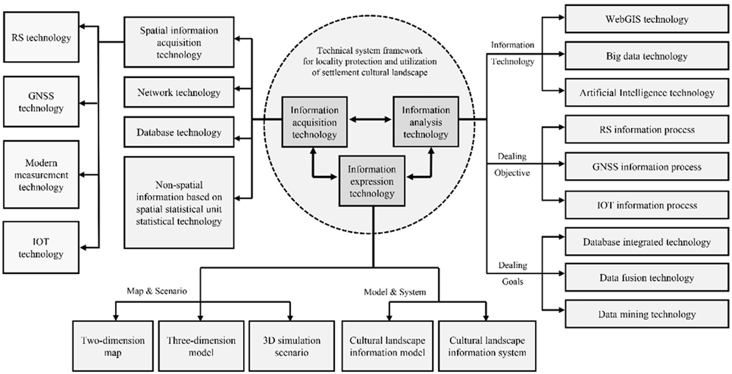
Technical system framework for the locality preservation and utilization of the settlement cultural landscape.
The main body of information acquisition technology is spatial information technology, involving RS, GNSS, IOT, etc. This is inseparable to the network technology, database technology, etc. Information analysis technology can be divided into WebGIS technology, spatio-temporal big data technology, AI technology, etc. Of course, it can also be classified according to information processing objects, information processing goals, etc. The information expression technology can be divided into map and scenario technology, and model and system technology, which can be used separately for different settlement cultural landscape types and locality preservation demands’ scenarios. The integration of three aspects of technology can be used to systematically evaluate the goal of the localiy preservation and utilization of the settlement cultural landscape.
Footnotes
Acknowledgements
The authors would like to thank Ms Zixin Feng for her help in language editing.
Authors' contribution
All authors contributed equally in the preparation of this manuscript
Declaration of conflicting interests
The author(s) declared no potential conflicts of interest with respect to the research, authorship, and/or publication of this article.
Funding
The author(s) disclose receipt of financial support for the research, authorship, and/or publication of this article from the Sino-German Centre (the National Natural Science Foundation of China and the German Science Foundation) (Grant No. GZ1457) and the National Natural Science Foundation of China (Grant No. 51378277).