
Abstract
Small villages have been central to progressive models of hunter-gatherer-fisher complexity on the Northwest Coast as a stage in the narrative of increasingly nonegalitarian social relations. We argue that Tsimshian settlement history is more complicated. We examine settlement and chronological data for 66 village sites in the Tsimshian area, 22 of which we define as small. Small villages were present in the area as early as 6500 years ago, but they are also contemporary with larger settlements until after 1300 years ago. We suggest that small villages represent a traditional Tsimshian social entity known as the wilnat’aał, or lineage, knowledge of which is preserved in Tsimshian oral records. We argue that the persistence of this settlement and community form illustrates the foundational role of this social unit throughout Tsimshian history, a result that has implications for archaeological research in the context of Indigenous history.
Keywords
Small villages play an important role in the archaeological narrative of Holocene developments on the Northwest Coast (NWC) of North America. As Ames and Martindale (2014) note, the NWC and particularly the Tsimshian case study are seen as an exemplar of the developmental trajectory toward social complexity 1 in hunter-gatherer-fishers. In this trajectory, small villages are precursors to larger village forms, a sequence that is argued to result from positive feedback between economic intensification and demographic growth. However, research in Tsimshian territory near Prince Rupert Harbour (PRH), British Columbia, Canada presented here suggests that history is more complicated than previously identified by local (e.g. Archer, 2001; Martindale, 2003) and regional (e.g. Matson and Coupland, 1995) researchers. Here we focus on the role of small villages and conclude that they predate larger forms, but that they are also contemporary both as discrete spatial entities and as appendages within larger settlements. We argue that village form may well correlate with historical principles that underlie the archaeological concept of complexity, but that other forces are at work as well. In particular, we note the correspondence between the small village form in its iterations over the Holocene and the wilnat’aał or lineage, a social entity that Tsimshian oral records indicate is an ancient and foundational principle in Tsimshian society.
We weave together two visions of Tsimshian history. From analysis of the Tsimshian oral record we argue that the wilnat’aał appear as the first social and spatial entity in Tsimshian history, sometimes in single villages within their territories and paired with their affinal parallels, the wilksiwitxw. At other times they appear as discrete villages in extensive settlement areas. Most recently they occur as components of galts’ap (tribes), either within their territories or again in settlement nodes, and in some cases in both. Our evaluation of the thesis of conjunction tests the archaeological data for evidence that the small village form is both taxonomically real and temporally persistent.
The simple-to-complex developmental sequence in NWC archaeology was proposed in the 1970s as both a description of the late Holocene archaeological sequence and an explanation for the origins of so-called complex hunter-gatherers (Fladmark et al., 1990). The argument, firmly established in Matson and Coupland’s (1995) landmark regional analysis, is that NWC history unfolded orthogenetically since the terminal Pleistocene as a progression from simple beginnings to a complex climax. The causal engine of this trajectory is a resource-demographic positive feedback loop spurred by the hypothesized development of anadromous fish populations consequent to postglacial ecological transformations.
Recently, new lines of evidence and analysis have emerged that challenge the exclusivity of this explanation, though not its foundational validity (Butler and Campbell, 2004; Cannon, 2002; Coupland et al., 2016; Grier, 2014; Lepofsky et al., 2009; Moss, 2011). Our own archaeological data fit into this pattern: they challenge a simple progressive trajectory but in identifying a more complex sequence do not reject the hypothesis that resource-demographic relationships are a pervasive force throughout the Holocene on the NWC. Instead we suggest that persistent cultural forces are also at work and visible archaeologically (see Martindale and Letham, 2011; Supernant and Cookson, 2014). NWC first nations have recorded histories that describe some of these principles and their spatial correlates.
This paper is a specific exploration of the conjunction between Tsimshian archaeological and oral records, emerging from the work of Marsden (1987, 1997, 2001, 2008, 2011, 2012, 2013), Martindale (2003, 2006, 2009), and Martindale and Marsden (2003, 2011). The archaeological response to the historical validity of oral records has followed a trajectory common to the academic acceptance of new ideas. Geertz (1973) noted that such debates include uncritical rejection or acceptance leading to faddishness and infatuation, which resolve only after the methodological rigor of any new approach is established. Similarly, Kuhn (1962) argued that scholarship exists within distinct idiosyncratic logical frameworks, the changes between which are largely epistemological, i.e. how knowledge is recognized and validated. Martindale and Nicholas (2014) extended the nature of such difference to cultural frameworks within which scholarship emerges. Thus, scholarly debates that cross significant cultural divisions are not only navigations of evidence and logic but also of less discursive assumptions, differences that lead to ideological rather than evidentiary debates.
Discussions of oral history and oral tradition tended to take a theoretical rather than a specific approach and often failed to distinguish between the different usage of the terms. Frequently the discussants had no personal experience with complex oral history research and failed to examine specific oral knowledge in the context of the culture to which it belongs (e.g. McGhee, 2008; Mason, 2000). Some debates on the theory of oral history are ideological and surprisingly emotional (e.g. Henige, 2009; Mason, 2000). With wider acceptance, which in Canada was triggered by the legal action of the Gitksan and Wetsuwet’en and the resulting Supreme Court of Canada’s Delgamuukw decision of 1997 (see Martindale, 2006), came greater scrutiny. The political nature of this subject, which aligns each discipline across a colonial divide, influenced the debate with advocates for the value of oral records arguing that their acceptance was a form of decolonization, thus a cause of moral activism, and, equally important, a valid source of historical knowledge. In contrast, critics focused on logical and evidentiary grounds, though with foundational double standards in which (1) the evaluation of cultural bias was only directed at the scholarship of oral records and not the archaeology and (2) oral systems of transmission were questioned without due analysis of the historical capacity of indigenous scholarly contexts, which were instead rejected simply because non-native archaeologists did not understand them. The associations with larger cultural dynamics have shifted the debate from separate assessments of archaeological and oral records with some consideration of conjunction between them, toward methodological issues. Here we return to what we argue is the foundational subject: do a well-sampled archaeological record and comprehensive analysis of a well-preserved oral record conjoin across events of quality and scale to be recorded adequately in both.
The authors in this paper do not purport to speak to every type of personal and societal activity described at one time or another as oral history; instead we offer (like Bernardini (2005) and Whiteley (2002)) a clear definition of the term as we use it in the context of a thorough knowledge of the NWC cultures with which we engage. Our understanding of NWC oral history is embedded in a detailed understanding of NWC cultures and based on decades of research with the peoples themselves.
Tsimshian, Gitksan, and Nisga’a oral histories, or adawx, are not personal remembrances, nor stories passed informally from one generation to the next, but rather legal documents owned by Tsimshian house groups, formally constructed by the lineage, validated by other lineages and passed on through word by word memorization and repeated iteration in ceremonial feasts by the chief and his heir. Since historical events are experienced by more than one lineage, the adawx together often describe events of such magnitude that they are reflected in the archaeological record. The adawx were the primary indigenous evidence at the well-known Supreme Court of Canada’s 1997 Delgamuukw ruling that set the global precedent for recognizing that oral records are historical sources rather than hearsay (Marsden, 1987; Martindale, 2006, 2014; Miller, 2011; Sterritt et al., 1998). Our work has most application in Tsimshian, Gitksan and Nisga’a history and in local legal debates (see Martindale, 2014). However, sufficient detailed case studies may reveal global patterns in the operation of oral traditions.
The Wilnat’aał and the Tsimshian, Gitksan and Nisga’a oral record
The territory of the Tsimshian nation encompasses the lower Skeena River watershed and the adjacent coast and coastal islands from Douglas Channel to the mouth of the Nass River (Marsden and Galois, 1995; Martindale and Marsden, 2011). Their neighbors are the Gitksan to the east, the Nisga’a to the north, and the Haisla and Heiltsuk to the south. Within the Tsimshian nation there are three regions in which the tribes are more closely integrated: the northern, southern, and interior Tsimshian. The interior Tsimshian are the Gits’ilaasu and Gits’mgeelm; the southern, the Gitk’a’ata and Gitkxaała. The northern Tsimshian are comprised of the once 10, now nine, tribes that wintered together in Metlakatla Pass in the PRH, currently the Gitwilgyoots, the Ginax’angiik, the Gitnadoiks, the Gitzaxłaał, Giluts’aaw, Gits’iis, Gispaxlo’ots, Gitlaan and Gitando.
The following is a summary of key social elements and changing settlement patterns of the Tsimshian and their neighbors, as understood from extensive research into their oral records (for direct reference to the adawx, see Marsden, 1987, 1997, 2001, 2008, 2011, 2012, 2013; Marsden and Galois, 1995; see Barbeau and Beynon, n.d.a, n.d.b, n.d.c, n.d.d, 1915–1957; Duff, n.d.; Robinson and Wright, 2003 for the adawx themselves). These texts reveal that in Tsimshian territory along the Skeena River, and on the adjacent coast and offshore islands, settlement patterns have varied from ancient times to the most recent period and from region to region; and yet common to all these patterns are fundamental social elements that consistently dictate the way the people organize themselves spatially. One of these is the wilnat’aał/wilksiwitxw relationship of lineages paired through marriage.
Each wilnat’aał began as a single matrilineal extended family group and over generations expanded to become a widespread network of house groups (for the explication of the concept of wilnat’aał and the evolution of the wilnat’aał see Marsden, 1987, 1997, 2001, 2008, 2011, 2012, 2013; Marsden and Galois, 1995). Some wilnat’aał were members of a clan from the earliest times, while others arrived on the NWC with no clan affiliation, such as those from areas to the south. From the beginning in the early postglacial period, the members of each wilnat’aał married outside their lineage (and clan) and therefore needed to be situated near at least one other such group. Intermarriage was therefore between local groups of the same two lineages, the wilnat’aał (where one sits), the mother’s side, and the wilksiwitxw/wilksiwatk (out of which one issues), the father’s side. As it expanded, each wilnat’aał perpetuated its identity through an interweaving of the complex elements of its adawx (lineage history), limx’ooy (ancient songs), and ayuks/dzapk (crests). This oral and visual record of each wilnat’aał’s history, from its ancient beginnings to the present, was made public through the yukw/yaawk (feasting system).
In the early postglacial period, as land was first settled, each wilnat’aał arrived on the NWC in search of an exclusive territory to sustain it. Where lineage groups were too large for the chosen territory, some among them moved on and established themselves elsewhere. In this way, a network of related offshoot groups was created over the region, each one eventually situated in its own territory and maintaining its ancient identity and kinship ties with others of its lineage. It is clear from the oral record that the earliest settlements were villages, that these were occupied by a single wilnat’aał, and that some groups lived in a form of wooden post and beam house. It is not clear, however, how many individual houses, or other types of dwellings, typically made up these early single wilnat’aał villages. It is also not clear at what point the house group (wilp/walp), a group of close kin who own and inhabit a house, came to be the fundamental landowning social unit of the wilnat’aał. Certainly at a very early time, the largest social unit of the wilnat’aał was the entire network of groups descended from the original lineage, dispersed throughout the region, and identified by the shared oral and visual record of their history.
Inland along the river valleys, single wilnat’aał villages of one or more houses were typically located at the edge of their territories, often across a river from their wilksiwitxw/wilksiwatk. Geographical features such as mountain ridges and rivers frequently served as territorial boundaries (Marsden, 2001). On the coast the paradigm was a single wilnat’aał village in an inlet or bay. These villages were surrounded by their territories and adjacent to the territories of their wilksiwitxw/wilksiwatk, similarly situated.
In the early to mid-Holocene as wilnat’aał/wilksiwitxw networks expanded, certain areas became more densely populated than others, resulting in a significant number of small single wilnat’aał villages located either along a river or on the shores of coastal islands. Most notable among these settlement areas were Temlaxam, centered at the confluence of the Skeena and Bulkley rivers (Marsden, 1987, 2011, 2012, 2013, Robinson and Wright, 2003; Sterritt et al., 1998), but reaching several miles up and down the Skeena River; and the extensive settlement areas on the Dundas Island group, Stephens Island and north Porcher Island (Figure 1). These were long-standing stable settlement areas, which probably remained relatively unchanged for several thousand years. In these clustered areas, each wilnat’aał village was no longer necessarily located within or even on the margin of its territory, instead accessing it by marine or river travel.
The study area (top), Prince Rupert Harbour (lower left) and Dundas (lower right) subregions showing place names and cultural areas.
At the same time, some wilnat’aał villages on the coast with contiguous territory (those on south Porcher Island, Banks Island, and Pitt Island, for example) came together at ceremonial gathering places, which later evolved into large seasonal tribal villages consisting of many wilnat’aał (Marsden, 2011). It was the ceremonial relationship between these groups that initiated the social unit the galts’ap, or tribe. These large tribal villages were made up of houses, some of which not only served as habitations but also as ceremonial buildings, or feast houses, and were often distinct in their size and design. The most enduring example of such a village is Laxklaan, now Gitkxaała. In most cases, each seasonal gathering place on the coast ultimately included wilnat’aał from all four Tsimshian clans, Gispwudwade/Giskaast (Killerwhale/Fireweed), Lax Ganeda (Frog/Raven), Lax Gibuu (Wolf), and Lax Xskiik (Eagle).
Large tribal villages of several wilnat’aał whose territories were contiguous also developed on the Skeena River, but these were year round villages from which the house groups travelled to their territories for various seasonal activities (Barbeau and Beynon, n.d.a, n.d.b, n.d.c, n.d.d). The inland tribal villages often included wilnat’aał of only two clans, usually Lax Ganeda and either Lax Gibuu or Giskaast and, to a lesser extent Lax Xskiik. Over time, ceremonial ties were also developed with neighboring tribes. The houses of the leading house groups of each wilnat’aał were also used as ceremonial houses and tended to be larger and located in the center of the row of houses that made up the village. The most enduring example of such a village was Gitanyow (Kitwancool) (Duff, 1959). These tribal villages, both on the coast and inland, were named after their location, for example, Gitksigyukla, People of the River of Sharp Rising Mountain, Gitwilgyoots, People Where Kelp, Gitnaxangiik, People of Place of Mosquitoes.
The galts’ap grew over time, from villages of single wilnat’aał each from a different clan, to include more than one wilnat’aał from each clan. In this significantly more complex village composition, the original identity of each wilnat’aał in these tribal villages was preserved and perpetuated in the wilp/walp or house group, the smallest unit of the wilnat’aał and the fundamental social and landowning unit of the galts’ap.
In the second half of the Holocene, trade became an integral aspect of the economy, provoking greater contact and integration throughout the region. Inland, the social/spatial unit of the tribe became entrenched, and component wilnat’aał within the galts’ap fostered trade ties with others in their wilnat’aał network. These connections strengthened relations and promoted intermarriage between tribes and ultimately larger networks of tribes (Barbeau and Beynon, n.d.a, n.d.b, n.d.c, n.d.d, 1915–1957; Duff, n.d.; Marsden and Galois, 1995; Robinson and Wright, 2003). The villages remained for the most part where they had always been, within the contiguous territories of their constituent house groups.
On the coast, the paradigm of wilnat’aał villages within their territories and a common ceremonial tribal village did not vary much over time except that the constituent house groups within tribes became even more integrated as time passed. As with the inland groups, relations between tribes were fostered through trade, often within a wilnat’aał network and through intermarriage. The groups on Stephens Island, north Porcher Island, and the Dundas Island archipelago differed somewhat: while the individual wilnat’aał came together into tribes, the tribes themselves became more closely integrated than elsewhere. A number of these tribal villages relocated to Metlakatla Pass for the winter months, moved together to their villages at the mouth of the Nass during the spring eulachon season, and returned to their island territories during the summer and fall.
In the late Holocene, the relatively uninterrupted evolution of these coastal groups from single wilnat’aał village to tribal villages was disrupted when coastal groups were repeatedly attacked by peoples from the north and were ultimately forced to leave their villages and take refuge on the lower Skeena River (Marsden, 2001). They eventually formed an alliance and drove off most of the invaders while accepting and integrating others, and in the process formed ties with some of the inland tribes on the lower Skeena River. As a result of these events, the tribes on the lower Skeena River joined with the coastal tribes for defense, and all groups in the region began to make their winter villages at Metlakatla Pass. With the integration of these tribes another social entity was formed, the settlement region consisting of different tribal villages, thus forming the northern, interior and southern groups of the Tsimshian nation. As a consequence of the alliance and either directly or through marriage, all the tribes that wintered at Metlakatla Pass now had villages at the eulachon grounds at the mouth of the Nass River, and seasonal villages on the coastal islands and on the lower Skeena River. While the pattern is sometimes described as a seasonal round followed every year by all the tribes, it is clear from the oral record that each year some wilnat’aał still wintered and/or spent the spring months in their villages in their coastal territories.
Thus, the wilnat’aał appears as the first social and spatial entity in Tsimshian and Gitksan history, sometimes in single villages within their territories and paired with their wilksiwitxw/wilksiwatk, at other times in discrete villages in territories, and most recently as components of tribes. We should therefore expect this complex history to be reflected in an equally complex archaeological record of settlement patterns. Specifically, we should expect the wilnat’aał to be reflected in the earliest spatial form, the small village, and in different iterations in ensuing eras through the Holocene.
The Raven Clan Wilnat’aał of the Gitzaxłaał, their territories, and the archaeological record
The preceding is a generalized overview of Tsimshian Holocene history from oral records, though detailed analyses of these sources can be found in Marsden (1987, 1997, 2001, 2008, 2011, 2012, 2013) and Martindale and Marsden (2003, 2011). Here we present a more detailed study of one tribe’s history, in this generalized context, to highlight the potential for another level of specificity and correlations between the oral and archaeological records that could be addressed, and also to indicate the complexity of the history and spatial manifestation of a single wilnat’aał when considered in more detail.
While in some areas the wilnat’aał/wilksiwitxw paradigm is seen readily in the record of owned territories—in the Gitkxaała territories on Banks Island, for example (Marsden, 2011)—the Dundas Island group and PRH social/spatial record is less obvious. Wilnat’aał of the early Raven clan of the Gitzaxłaał, one of the nine tribes of the northern Tsimshian, were among the first to claim these territories. The Gitzaxłaał established their ownership of the Dundas Island group in this early period and they remain its owners to this day. A branch of this wilnat’aał moved north to help found the first Tlingit Raven Clan groups, who were among the first founders of Tlingit villages. It is significant that the oldest site in Tsimshian territory is GcTr-6 (Figure 1) is on Dunira Island, radiocarbon dated to 9690 RCYBP (10885–11204 cal BP) (McLaren et al., 2011). It is most likely that these very early wilnat’aał on the Dundas Island group resided there year round, perhaps in different villages depending on the season.
The early Raven clan wilnat’aał of the Gitzaxłaał was also among the earliest groups to establish a village at Metlakatla Pass, at Kgadu, an area comprising the northern tip of Digby Island (Duff, n.d.). Recently the oldest radiocarbon dated archaeological site in PRH (GbTo-185) was discovered in this area dating to 8220 RCYBP (9028–9304 cal BP) (Letham et al., 2016). This Raven clan wilnat’aał of the Gitzaxłaał was also the first to claim portions of the Ecstall River watershed at the mouth of the Skeena River (Duff, n.d.), and to found Spaksuut (Fall Place), the village at the mouth of the Ecstall River, the fall village of all the Gitzaxłaał wilnat’aał. Further archaeological investigation of and near these three places could yield important information on the earliest settlement patterns of this wilnat’aał. In the case of Spaksuut, which is said to have been occupied from the earliest times to the contact period, archaeological research could further elucidate the discussion of the small village type. Such work could also enrich the history of the Gitzaxłaał by dating the acquisition of their territories and the founding of their earliest villages.
While in some cases areas were first settled by a number of wilnat’aał, who then resided in their territories and later formed tribal villages with their neighbors, in other cases, as with the early Raven clan wilnat’aał of the Gitzaxłaał, the earliest arrivals acquired large territories with abundant resources, which over time they gave others permission to use, while never ceding their ownership. This permission became a fundamental legal principle of the indigenous system of land title.
At some point, probably in the second half of the Holocene, the Gitzaxłaał developed a seasonal round that included their Ecstall River villages, fishing sites on the lower Skeena River and eulachon fishery sites at the mouth of the Nass River (Duff, n.d.). At this time, “use with permission” of the territories by other wilnat’aał became more common. While the Dundas Island group always remained the territory of the wilnat’aał of the Gitzaxłaał Raven clan, the wilnat’aał of the other Gitzaxłaał clans (the Wolf and Killerwhale) were given permission to share specific villages for certain activities such as seaweed and shellfish gathering, sea mammal hunting, salmon fishing, halibut fishing and birds’ egg collecting. Laxkwilwaał (On Where Yellow Cedar), for example (in the area of the village at GcTr-26, Figure 1, and situated in a highly productive seaweed zone) was a seaweed gathering village used by all the Gitzaxłaał (Duff, n.d.). This village site with two rows of eight small houses, were it to be dated, could be interpreted as a single wilnat’aał, village or seasonal village used by all the Gitzaxłaał wilnat’aał. Another such site, Laxwil’uksp’iins, for example (in the area of GcTq-1 and GcTq-6, Figure 1) was a village used by all the Gitzaxłaał for sea mammal hunting.
An influx of peoples began in the late Holocene, about 4000-3000 years ago (Martindale et al., in press), when the southernmost Tlingit branch of this Raven clan wilnat’aał were invaded from the north and took refuge among others of their wilnat’aał, the Gitzaxłaał Raven clan in the Dundas Island group (Marsden, 2001). The famous Tlingit leader Kagaa is said to have become established over time among the Gitzaxłaał beginning at the northern end of Dundas Island and, at some point, building a village at Laxkwinwaats where he constructed a da’ax or terraced chief’s house on the northwestern peninsula of Dunira Island in the area of GcTr-6. To date, no archaeological evidence of da’ax has been identified in this area, but the remains of another possible da’ax has been identified north of Baron Island as part of a large village site dating to 2700 to 1300 BP, GcTr-5 (Figure 1). The invaders continued to move south and eventually forced the newly arrived Tlingit and all the northern Tsimshian to relocate to fortified sites on the lower Skeena River. The coastal Tsimshian and their river allies ultimately defeated the invaders and the tribes became a new more integrated sociopolitical entity in a settlement area consisting of closely situated tribal villages in Metlakatla Pass (Marsden, 2001).
As the example of the Gitzaxłaał has indicated, it is difficult to make specific correlations with archaeological data but the potential is significant when the oral record informs the design of the archaeological research. At this point, however, the strongest similarity occurs at a broad spatial and temporal scale, and it is the case that throughout the history of the Tsimshian and their evolving sociopolitical entities, the fundamental social element of the wilnat’aał remained a constant; and, as the archaeological data shows, its spatial form, the small village, also persisted throughout the Holocene. Further archaeological work, using methods discussed below, could track the settlement history of these areas, potentially identifying specific lineage groups and their interactions over the last 5000 years.
Northern Tsimshian archaeology
The challenge for archaeologists working in the context of rich oral records is similar to that of classical or historical archaeologists: finding connections between material evidence and historical data, although this is exacerbated by colonial-infused expectations that undervalue Indigenous oral records (Marsden, 2002; Martindale, 2006, 2009; Martindale and Nicholas, 2014). Since culture and its histories are inevitably more complex than the material gestures they produce, archaeology always presents an attenuated view of the past. However, as Martindale and Marsden (2003) demonstrated, the conjunction between history and archaeology increases with scale: more people creating similar patterns over longer periods of time are more visible in both archaeological and historical (in this case, oral) records. In this section we consider the archaeological data of small villages as potential correlates for wilnat’aał.
Archaeology in Tsimshian territory (Figure 2) has been ongoing for almost a century, much of it focused on the massive village shell middens of the PRH area (Ames and Martindale, 2014). Rocky foreshores, high relief bedrock outcrops, and low-lying wetlands characterize the coastline. Naturally occurring well-drained and level terraces suitable for human occupation are limited, suggesting that the widespread use of shell terracing is an engineered solution. Villages have been distinguished from nonvillage shell middens based on the presence of surface house depressions (Archer, 2001); middens without visible surface architecture are sometimes called camps (see Brewster and Martindale, 2011; Cannon, 2002). There is size modality in shell-bearing sites (Archer, 1988; Letham et al., 2015). It is not clear if this variation is a developmental sequence or functional variation.
Archaeological site locations in the Dundas (upper), Prince Rupert Harbour (middle) and Stephens (lower) areas.
In Tsimshian territory, the remains of houses are identified as semisubterranean structural depressions with raised berms produced by the postconstruction accumulation of shell (Archer, 2001). Small villages are defined as sites with a small number (<10) of small houses (∼ 4 m × 6 m); large villages are identified as sites with larger numbers of houses (>20), multiple house rows, and a range of house sizes including those that are very large (>10 m × 15 m) (Archer, 1992, 2001; Coupland, 1985, 2006). These differences in village layouts have been interpreted as indicative of a transition from more egalitarian to more hierarchical society (Archer, 2001). Large houses within large villages are interpreted as evidence of ethnographically known social patterns of chiefs within village groups associated with tribes (Coupland, 2006; Drucker, 1983; Halpin and Seguin, 1990).
We suggest that in the context of an overall trend toward complexity (following Archer, 2001) that likely emerges from the weak but continual economic pressure of necessity, recent data also reflect the influence of persistent cultural and historical forces that echo the Tsimshian oral record. We argue that small villages do not represent simply a stage in developmental history, but also the material manifestation of the wilnaat’aał, which is the foundational social unit for the continuity of Tsimshian history over the Holocene. Small villages are also visible as subcomponents of large villages and we hypothesize that the development of large villages reflects the amalgamation of wilnaat’aał as reported in the oral record.
Research questions and methods
How small villages fit into the developmental sequence and how the archaeological data conform to interpretive expectations about complexity and potential correlates to oral records are predicated on three logically linked questions. First, are small villages a demonstrable site type and what other forms exist? Second, is the sample of villages and dates in our data set representative of the population of villages in Tsimshian history and sufficient to monitor their emergence and duration? Third, are village layouts visible on the sites’ surfaces sufficiently representative of architecture to monitor settlement and residential changes? We address each of these in the next sections and argue that all three conditions are met in our data.
Village taxonomy
Villages in the study area.
Taxonomic criteria, established in Martindale (2013) include four categories of metrics each with constituent variables: (1) terrace (comprised of area and length/width proportion), (2) house (comprised of number, area, orientation, and length/width proportion), (3) row (comprised of number, length, orientation, and curvature) and (4) variation (comprised of coefficients of variation for metrics 1–3). All variables were calibrated against maximum and minimum values in the data set and clusters were computed resulting in the sorting of Table 1, which we refer to paradigmatically by size and row curvature.
GbTo-4 includes two village areas separated by an engineered shell causeway, the only case of this construction in the sample.
Sites with asterisks are recorded ethnohistorically as being occupied in the 18th and 19th centuries.
Some sites in the study area are on Indian Reserve lands and not required to be registered with the British Columbia Archaeology Branch. The choice to submit is held by the First Nation. Such sites have been assigned temporary numbers.
Some sites have multiple site numbers (GcTo-2 and GcTo-8; GcTo-4, GcTo-5, GcTo-10, GcT0-11; GbTo-10 and GbTo-33) for different components.
The four study areas have been surveyed to differing degrees: PRH ( ∼ 100%, Dundas 50%, Lucy ∼100%, Stephens 1%).
Sample representativeness
Research pioneered by Fedje and Christensen (1999) showed that the modern shorelines of the NWC are a mid- to late-Holocene stabilization and that early- to mid-Holocene coastal archaeological data are more likely to be found at elevations above or below the modern shore. Data from the Dundas archipelago (McLaren, 2008; McLaren et al., 2011, 2014) map a relative sea level regression since the glaciated late Pleistocene from at least 14 m asl after 14,000 years ago with evidence of still stand stabilization at 7.5 m asl between 8850 and 6100 cal. BP. The Dundas survey used this information and included terraces at or slightly above 7.5 m asl in its assessment.
Though not tested per se, we predict a similar pattern of relative sea level change for the Stephens Island area based on similarity to Dundas in its location relative to tectonic plate boundaries and the edge (and thus axis of load) of Pleistocene glaciation. In PRH, relative sea level changed much more dramatically during the terminal Pleistocene as a result of having been more isostatically depressed by glacial load, though by the Holocene the rate of change became more gradual; relative sea level position slowly dropped from ∼4 m asl to its current position between 6000 and 1500 BP, with some potential minor fluctuations within that time (Letham et al., 2016). Although the PRH has been extensively surveyed and has a considerable site inventory, these surveys have focused on the modern shoreline, and therefore the archaeological data are skewed to the last 6000 years and cannot be considered representative of early times. Consequently, we can only rely on the Dundas Island area for early to mid-Holocene patterns, although findings from the Dundas Islands, Stephens Islands and PRH areas can be combined to query mid- to late-Holocene trends.
Data collected from small villages in the study area.
AT: auger test; CT: core test; ST: shovel test.
Site area estimates were taken from RAAD (the British Columbia Remote Access to Archaeological Data database) and checked against both archaeological plan maps and LiDAR data.
All dates were calibrated using OxCal 4.2 (Bronk Ramsey C, 2014).All terrestrial dates were calibrated using IntCal13 curve and all marine dates were calibrated using Marine13 curve (Reimer et al. 2013) and using Delta-R of 273 ± 38 (Edinborough et al., 2016).
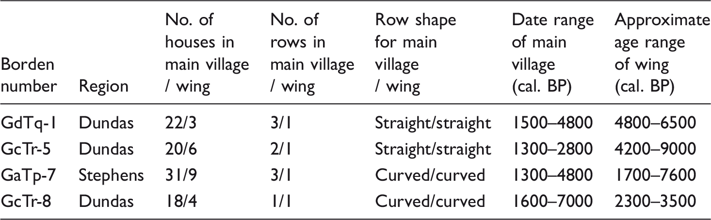
Two separate village components of one row of houses (n = 2, n = 3) facing opposite directions.
Two separate village components of rows (n = 1, n = 2) of houses (n = 1, n = 11) facing opposite directions.
Two separate village components of rows (n = 1, n = 2) of houses (n = 4, n = 9) facing opposite directions.
Surface–subsurface correlations in terminal components
Prior to this project, the use of surface contour data as proxies for subsurface architectural patterns had not been tested, although excavations of house depressions in the region have found houses (Coupland et al., 2010). Archer (2001) made a convincing case for a strong correlation between the midpoint of the upper and lower slope breaks within house depressions and the original exterior wall of the structure, based on physical properties of aggregated shell. Patton (2011: 194) argued that her results from GbTo-77 suggested a less clear correspondence between slope breaks in the surface depression and the building perimeter. We expanded Patton’s test of Archer’s thesis at GdTq-3 (a small village dating up to about 5500 cal. BP, see below) and GdTq-5 (a large village dating to about 1300 cal. BP) using excavations that removed the overlying humus and postoccupation soils to explore the most recent position of structures in relation to the depressions (see Martindale et al., 2010 for details, see Figure 2 for site locations). Our results are insufficient to fully test correlations between surface contours and subsurface architecture in the study area, but suggest that in many instances the house wall is best approximated as the midpoint of the upper and lower slope breaks. Factors such as house pit excavation, shifts in wall alignment during reconstruction and repair, and deep soil formation, however, make for less accurate correspondence between surface and subsurface contours. At GdTq-3, the surface depression was distorted to trapezoidal and was displaced and rotated from the structure’s original position. The remains of this house structure were about 5000 years old and were covered with more than 1.25 m of A-Horizon. GdTq-3 was the only small village where trapezoidal surface features were observed. As such, we conclude that surface contours can approximate subsurface architectural patterns for the terminal occupation, but that such correlations likely decrease with age.
Spatial results and analysis
We conclude from the above that small villages are a definable site type, that the sample is representative and that surface patterns reflect subsurface architecture. Here we proceed to an analysis of the role of small villages in Tsimshian territory at two scales: patterns within villages and patterns between villages.
Patterns within villages
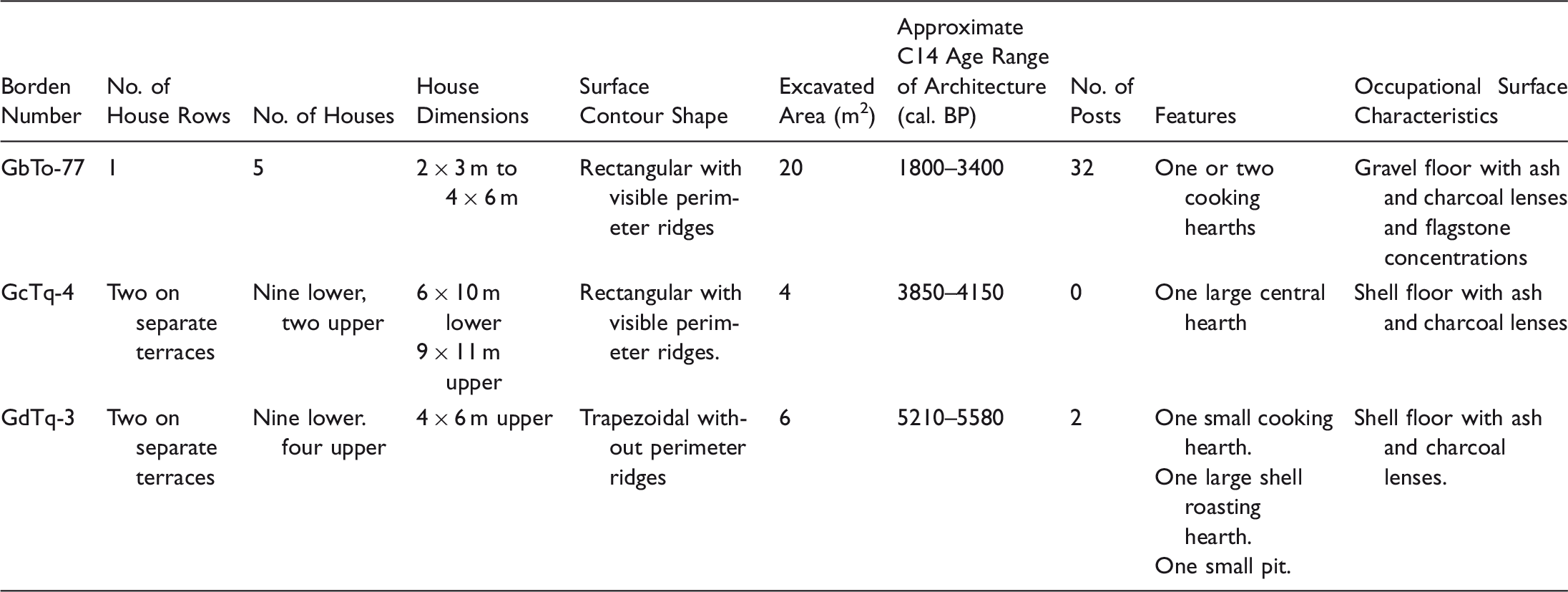
GdTq-3 (Figure 3) is located on the Dundas Islands, on an islet between Baron and Dundas islands (Figure 2). It consists of a ridge at 9.5 m asl with shell midden and a lower elevation terrace (3–4 m asl) both containing surface depressions. The higher shell ridge contains four small depressions and the lower terrace, nine. However, it is unlikely that the terrace and ridge occupations are contemporaneous. The shell ridge has upper and lower dates of 4978–5505 cal. BP (Beta 215183) and 6907–7303 cal. BP (Beta 215180), from a period when the relative sea level was 5 m higher than today (McLaren et al., 2011). The house features themselves date to between 6800 and 5900 cal. BP (Table 2), although one charcoal date (D-AMS 007907) was more recent and could represent reuse of this area of the site at a later date. It is likely that the surface depressions on the upper shell ridge represent a cluster of houses from the mid-Holocene that faced a small bay on the southeast side of the site. This component is the earliest known village in Tsimshian territory. Its row of four small houses may capture an early Holocene pattern that recurs in later sites. Its location atop a deep shell midden suggests that this form may have earlier antecedents. The house depressions on the lower terrace are arranged in two rows and represent a separate occupation in the late Holocene, an example of the persistence of the small village form. GdTq-3 is a rare case of a small village with more than one house row (others include GcTq-4, GbTo-66, 72, and GcTo-27).
Site Map of GdTq-3 with excavation results insert. Note this map differs from Letham et al. (2015) that presented surface contour patterns; this figure illustrates house dimensions based on excavation results of surface–subsurface correlations.
GcTq-4 is located on an islet between Baron and Dunira islands in the Dundas Island archipelago (Figures 2 and 4) and it also has two components: a small village located on a lower (4.5–6.5 m asl), front terrace, and an older shell midden located on a higher (9.5–11.5 m asl) back terrace. The lower terrace contains at least two rows of small (approximately 6 m × 10 m) similar-sized structural depressions orientated to the southwest beach. The higher, back shell ridge contains two structural depressions. These are both larger (approximately 9 m × 11 m) than the depressions on the terrace below (Ruggles, 2007).
Site Map of GcTq-4 with excavation results inset.
The higher elevation shell ridge has basal and upper dates of 6802–7261 cal. BP (Beta 215178) and 5123–5562 cal. BP (Beta 215179), times when the lower terrace would have been at mean sea level and uninhabitable. However, a charcoal sample from the hearth at the center of house pit 1 on the upper terrace dates to 3843–4141 cal. BP (TO-13309), indicating that this structure was built into the existing older midden at a time when relative sea level had dropped to its present elevation. We interpret house pit 1 as a residence, either constructed between the occupations of the back midden and the village on the lower terrace, or at the same time as the lower terrace houses, which must date to after about 5000 years ago. Thus, GcTq-4 has origins before 7000 years ago, but the earliest direct evidence for its occupation as a village dates from after 4000 years ago.
GbTo-77 is on the northwest shore of Digby Island in the PRH area (Figures 2 and 5). It has six surface depressions rimmed by a relatively small, shallow midden with a depth of often less than 1.5 m. Five small, but clearly defined depressions (approximately 3 m × 4 m to 4 m × 6 m) are arranged in a single row with a single very small outlier. Consistent with other village sites in the harbor, a back midden ridge rises behind the surface depressions (approximately 2 m in depth). From 2003 to 2005, Patton (2011) excavated two surface depressions (A and D in Figure 5) and the back midden at this site. GbTo-77 was likely inhabited between about 3000 and 2000 years ago (Table 2). Dates on charcoal from the top and middle sections of the back midden are virtually identical, suggesting rapid accumulation of the terrace platform. The hearth date (3068–3380 cal. BP, TO-12056) is much older than the other radiocarbon dates associated with this site; it may be an outlier caused by the burning of old wood (Schiffer, 1986).
Site Map of GbTo-77 with excavation results inset.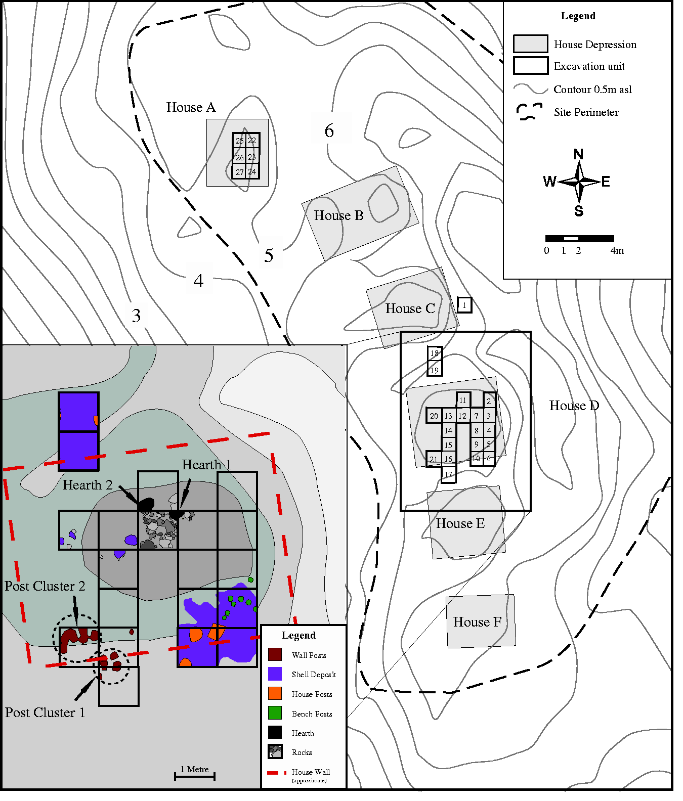
Excavation results from surface depression D and auger tests within the main row depressions demonstrated these structures were built on sterile gravels, not earlier midden as was the case at GdTq-3 and GcTq-4. The stratigraphic, architectural and radiocarbon data define this as a small village built onto a previously unoccupied landform about 3000 years ago.
Excavation data from GbTo-77, GcTq-4, and GdTq-3.
Wings
Patterns in large villages with wing components.
Patterns between villages
Figure 6 shows a boxplot of pooled probability for radiocarbon dates for each village type (small straight rowed, large straight rowed, large U-rowed, and large Late Period; the latter are large villages with documented occupations in the postcontact era). While pooled probability charts obscure separate components within sites representing separate occupations, they are useful when the comparable data sets can be refined in some way. In this case, we illustrate basal and terminal components in addition to total pooled probability for each village type.
Boxplots of pooled probability of radiocarbon dates versus site type in the study area. LP = Late Period Villages (Total: n = 181, Basal: n = 30, Terminal: n = 23), LC = Large Curved Villages (Total: n = 20, Basal: n = 6, Terminal: n = 9), LS = Large Straight Villages (Total: n = 106, Basal: n = 27, Terminal: n = 44), SS = Small Straight Villages (Total: n = 130, Basal: n = 30, Terminal: n = 24). Values in the Y-axis are in calibrated years BP using OxCal with Marine13 and Intcal13. Marine dates were corrected for reservoir effect using Delta R 273 ± 38 (see Edinborough et al., 2016). Dates from human bone were assumed to have 90 percent marine diet. All dates derived from the Canadian Archaeological Radiocarbon Database (CARD) (Martindale et al., 2016) or collected by the authors. Statistics are midline = mean, shaded box = interquartiles, whiskers = 1 sigma, dots = outliers. Late Period large villages defined from ethnohistoric records as GbTo-4, 6, 10, 23, 31, 33, 34, and GcTo-1.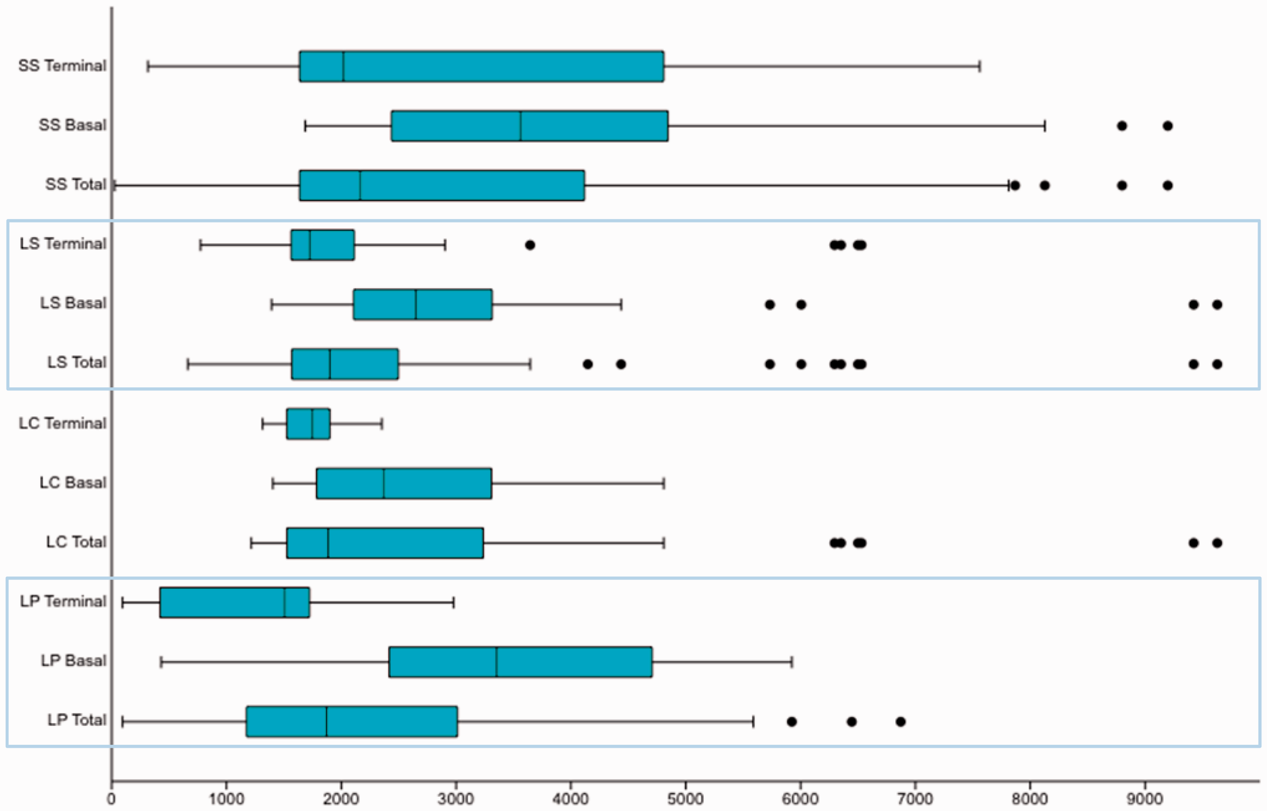
Several observations are possible from these data. First, the majority of smaller villages have dates beginning around 5000 years ago, preceding large villages. Our data are least clear on the origins of large, deeply stratified villages. As Martindale et al. (2009) showed, large villages can overlie smaller occupation components. In that analysis, the large village of GcTr-8 dated to about 3000–1300 years ago even though the basal dates at the site were over 7000 years old. Second, the trends of basal dates at large villages indicate that both straight and curved forms have basal components dating to before 9000 years ago, but that the majority date from after 3500 years ago. However, what is clear is that even as large villages appear, small villages persist (Ames, 2005: 299–301). The basal dates of many small villages postdate 3000 years ago (Table 1). Third, late period forms are a subgroup of the straight rowed that are known to have been occupied up to the historic period; as Marsden (2001), Martindale and Marsden (2003), and Supernant and Cookson (2014) note, this difference appears to reflect a settlement reorganization associated with a period of warfare after 1300 years ago. After this time, only Late Period villages in the PRH are occupied, a significant territory-wide settlement shift. Importantly, two late period villages (GbTo-6 and GbTo-54) are small, indicating that spatial manifestations of social form continue to be complex after the regional reordering. In sum, the archaeological data show resolvable patterns in space and time: (a) small villages are the earliest spatial form: (b) after about 4000 years ago large villages appear, some of which contain small village-like subunits as wings: (c) until about 1300 years ago, people in the region lived in both large and small villages: and (d) after about 1300 cal. BP, most small villages and many large villages were abandoned for a small suite of villages, the ethnographically known subset concentrated exclusively in the PRH area.
Discussion
Our archaeological work demonstrates that the territories of the northern Tsimshian contain a number of distinct village types patterned over space and time. Village life began at least 6500 years ago, although the Tsimshian oral record indicates that the first villages were earlier and coincident with the first people to reside in the area, archaeological evidence of which exists from over 10,000 years ago. Small villages are the first form of village in the areas for which we have early data: the Dundas and Stephens outer island groups. Thus, the archaeological record is comparable to the oral records for the earliest period: small villages scattered across the region. We argue that these spatial patterns in archaeological data conform well to the spatial implications of social patterns for wilnat’aał described in the Tsimshian oral record.
Early villages were similar in terms of house construction and settlement layout to later villages, only smaller. The most significant changes in our data over time are (a) the increase in village size in terms of area, volume of shell, and number of houses, and (b) the change from villages containing houses of uniform (small) size to those containing small and large houses. From our data, we can only estimate that this occurred somewhere in and around 4500–3000 years ago. Some of these larger forms contain wing components that are spatially similar to small villages, suggesting that the larger villages are to some degree and in some contexts amalgams of smaller spatial entities. The history of these developments seems to vary between straight-rowed forms (the earliest and the most common) and U-rowed forms (later and known only in three cases). Our data are clear that small villages as independent sites persist even in the context of large villages. Patterning in surface depressions at later large villages suggests that people held onto the social ties that configured earlier small villages even as the tribal galts’ap emerged. The development of wings, either as extensions of large or small villages, suggests that people moved en masse but that the social order of the older settlement form remained important. Again, this conforms to the oral record and its description of the enduring role of wilnat’aał within the tribal village. Thus, the variations in villages through the mid-Holocene align well with the oral record’s accounts of the integrations of wilnat’aał into ceremonial and tribal communities.
The settlement patterns are largely consistent across the region in the early and mid-Holocene but differ markedly in the late-Holocene. After about 1300 years ago, many large and small villages in the region are abandoned at about the same time. The only exceptions are a subset of villages in the PRH that continue into the contact era. This period of village abandonment or hiatus aligns well with the oral record accounts of Tsimshian relocation to defensive sites from coastal territories in the face of northern invaders (Marsden, 2001). Thus, as a test of the broad patterns of the oral record, the archaeological data presented here do not disprove the history of the adawx.
Conclusions
This research is presented in the context of ongoing legal proceedings that evaluate the conjunction between archaeological and oral records (Miller, 2011). Our data suggest that a simple progressive model of village form deriving from resource-demographic dynamics has merit but does not fully capture either social complexity or the archaeological evidence of settlement history in Tsimshian territory; this challenges pervasive archaeological expectations of a link between demography and so-called complexity (see e.g. Henrich et al., 2016). While specific points of conjunction exist between the material patterns and the Tsimshian oral record, the strongest similarity occurs at a broad spatial and temporal scale. In archaeological terms this is the small village/wing; in oral records it is the wilnat’aał; we conclude that the former is the spatial manifestation of the latter.
Much of our recent archaeological work (Ames and Martindale, 2014: Martindale and Letham, 2011; Martindale and Nicholas, 2014) argues that Indigenous NWC history is complicated, and the data presented here illustrate the heterogeneity of the NWC archaeological record. The implication of our work is that the oral record is significantly more fulsome than the extant archaeological data. Thus, archaeologists would benefit from a concerted effort to shape their working hypotheses in the context of a greater understanding of indigenous history, one that focuses on the frameworks of cultural expectation that mediate history. The challenges of doing so are considerable since (1) the cultural frame from which Indigenous knowledge emerges is heterogeneous and the records of oral history, like any history, only capture facets of the past and (2) identifying the material expression of large-scale events and processes requires a substantial archaeological sample. However, we demonstrate the value of interdisciplinary partnerships between historians, indigenous scholars, and archaeologists to this purpose.
Footnotes
Acknowledgements
We would like to thank the Lax Kw’alaams and Metlakatla Indian Bands for their support of this project. We thank Gary Coupland for his support of excavations at GbTo-77. Funding and logistical support was provided by SSHRC, NSF, Wenner-Gren (dissertation field work grant), Lax Kw’alaams Indian Band, Metlakatla Indian Band and Kleanza Consulting Limited. Nexen Energy ULC provided the Prince Rupert Harbour LiDAR data. Sue Formosa collected data and developed the maps for GcTr-8, GdTq-3 and GdTq-4.