
Abstract
Scholarship in visual communications, media, and geography explore how news media assign meanings to environment through narratives of and about place. In this study, however, the author aims to move scholarship from evaluating journalistic place representations to exploring the cultural and ideological processes of how these place representations come to be. Understanding how journalists construct place adds depth to knowledge about news as a social and cultural construction, and contributes to previous research on news place-characterizations. This study enacts a methodology called ‘mental mapping’ and serves as a call for communication scholars to consider such participatory methods. Data for this study come from interviews with 30 participants, including reporters from three newspapers, public officials, and residents of Iowa City, USA. In the end, this study identifies a visual methodology for exploring the role and influence of how journalists work and represent place in the news, a process the author calls news place-making.
Introduction
Iowa City, Iowa’s southeastern neighborhoods – known as the ‘Southeast Side’ – looks fairly benign: rows of single-family, ranch-style homes stretch along tree-lined streets next to townhouses, a park, schools, and apartment buildings, soccer fields, and a community garden. But in a city of 70,000 that is roughly 82 percent white, the ‘Southeast Side’ is home to a majority of the city’s black residents thought to have moved there from the inner cores of Chicago and St Louis (Keene et al., 2010) and has become synonymous with notions of ‘the inner city’ (Burgess, 1985) and the ‘ghetto’ (Wilson, 1997). Following a street melée on Mother’s Day 2009, stabbings, and a murder, local news coverage of these neighborhoods has connected the ‘Southeast Side’ label (Keppler, 2009) to tales of urban, black residents who allegedly misuse public welfare (Conzemius, 2010; Hennigan, 2009, 2010), spread poverty and ‘black culture’ into local schools (Roth, 2009), and generate mounting levels of crime that distract police from serving the broader community (Hermiston, 2010).
And while Southeast Side residents tend to dispute those characterizations (Bailey et al., 2011; Keene et al., 2010), news explanations for social conditions in southeastern neighborhoods and a continued migration of blacks to Iowa City from larger cities follow traditional, racialized narratives of blacks as dangerous, pathological, and coming from fractured families (Forman and Neal, 2004; Gutsche, 2014a, 2014b; Stabile, 2006). The Southeast Side, then, has become an ideograph (McGee, 1980) for the ghetto and an example of how journalists construct notions of place (Soja, 2010). Scholarship from the fields of visual communications, mass communications, and geography explore similar ways of how news media assign meanings to everyday life, including by presenting local news through larger, cultural narratives of and about people and places (Adams and Jansson, 2012; Cloke et al., 2004; Gutsche, 2011; Hallin, 1986). In this study, however, I hope to move scholarship from evaluating journalistic place representations to exploring the cultural and ideological processes of how these place representations come to be.
This study enacts a methodology called ‘mental mapping’ (Gould and White, 1993; Norwood, 2009; Wood, 2010), ‘speaking landscapes’ of words, images, colors, and one’s personal experiences with geography (Lynch, 1980) as an attempt to diminish the power differential between researcher and the researched. Maps have been identified as a medium to express emotional, ideological, and physical interactions with geography (Cloke et al., 2004; Johnson, 2007; Ladd, 1967) and exist in a similar methodological and ontological framework of visual scholars who use drawing and photography to document and explicate social phenomena (for example, see Mutonyi and Kendrick, 2011; Ranker, 2012).
Data for this study come from interviews with 30 participants, including reporters from three newspapers, public officials, and Iowa City residents that explore the role of journalists in characterizing place. During the interviews, participants drew maps of the city to discuss how their varying social roles influenced their perceptions of city spaces and causes for social conditions in the Southeast Side. Below, I begin with a brief description of the geography and news coverage at the center of this study. Next, I discuss relevant scholarship about constructions and storytelling of geography. I then present and describe participants’ mental maps as a method to explore place-making in local news media and promote mental mapping as a tool for future media research.
Background
A fairly racially homogeneous city, as with others in the state, Iowa City has become a destination for nearly 50,000 blacks since the 1980s (State Data Center, 2012), settling in a region that continues to be more than 90 percent white (Figure 1). By 2000, Iowa City’s Southeast Side neighborhoods were growing as much as six times faster than other neighborhoods and were home to the highest concentration of racial minorities in the city.
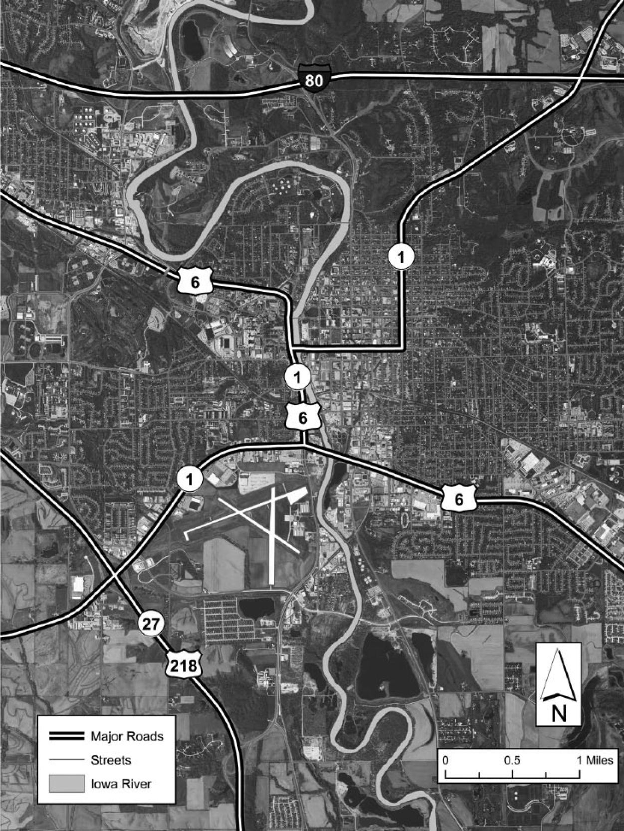
Iowa City, Iowa, 2012. © Tyler Johnson.
By 2009, blacks and Latinos here were double that of the city’s average (Bailey et al., 2011). In 2012, Iowa City was 82 percent white, 6 percent black, 7 percent Asian, and 5 percent Latino (US Census, 2012).
As cultural rifts between long-time white residents and black newcomers increased, news coverage of the city and its Southeast Side in The Iowa City Press Citizen, The (Cedar Rapids) Gazette, and The Daily Iowan, the University of Iowa student newspaper, began explaining news from the Southeast Side as being influenced by ‘ghetto’ culture (Gutsche, 2011; Spence et al., 2010). Characterizations of the Southeast Side as ‘the inner city’ or as a ghetto were reinforced, however subtly, in comparisons of the Southeast Side to urban centers and, more specifically, to a trend of increasing homelessness in Iowa City that apparently is rampant in cities.
Possibly the strongest example of racialized discourse that characterized the Southeast Side as a ghetto appeared in an opinion piece selected by editors headlined ‘Perpetrators of urban decay’ (Conzemius, 2010). 1 In this piece, the author writes about the neighborhood’s changing culture and claims that ‘inner-city refugees’ from Chicago bring ‘their bad habits with them, and soon Iowa City residents have more dead bolts and locks on their doors’. Other coverage of disorder in Iowa City – particularly street violence among white college students that had made the city’s downtown the most violent geography – further marginalized the Southeast Side and cast it as an ‘undesirable’ place. One news story about college students downtown headlined ‘IC’s Mean Streets’ labeled drunken and violent white, college men ‘roving packs’ clarifying, however, that assaults and vandalism were mere ‘entertainment’ (Zilbermints, 2009). Most coverage of the Southeast Side’s social conditions blamed pathological ‘black culture’ that was bred and maintained in a particular geography (for example, see Conzemius, 2010; Gutsche, 2011; Heldt, 2009; Hermiston, 2009; O’Leary, 2009).
Conceptual Framework
As I watched news coverage of the Southeast Side unfold, I wondered how and why news media came to assign meanings to this part of the city. 2 Southeast Side residents I met rejected representations of their neighborhood as a ghetto that appeared in the press, and had been on-record saying so to researchers (Bailey et al., 2011; Keene et al., 2010; Spence et al., 2010). Yet, residents’ descriptions of the Southeast Side rarely appeared in news stories. Instead, journalists appeared to rely on official sources and other neighborhood ‘outsiders’ to characterize the neighborhood as an extension of inner-city ghettos. Therefore, as a journalist and researcher, I became most interested in place-making as a journalistic function (for example, see Gutsche, 2014c; Hallin, 1986; Zelizer, 1993) to add a deeper understanding of the cultural and ideological work of news. 3 To explore place-making, I turned to mapping as a visual story to describe and explain everyday life.
Visual Storytelling of Geography in Everyday Life
Historically, mapping has served as a means to identify and describe stories about geography. Traditionally, maps have been drawn on cloth or paper, carved in metal and stone, or now molded through interactive computer simulations. Yet, because individuals experience geography in unique ways, material maps cannot fully capture the layered meanings of environments, and it becomes important to involve discussion about, or with, mapmakers to explicate a map’s dominant and alternative messages. In this way, ‘vernacular’ mapping explores the counter-narratives of place-making among subjugated people and cultures by focusing on participants’ use of words and drawings as a response to dominant/Western ideologies (Caquard, 2011). In other words, maps are stories that identify economies, personal stories, and colonization that may not be readily noticed – if noticed at all – in dominant place-representations.
In the United States, for instance, Johnson (2007: 106) writes that native peoples represented ‘context and history … rather than representing the earth to a standard scale’ by highlighting the ‘cultural significance’ of place and topography in maps. These maps, then, came to identify one’s ‘life pathways’ through ‘internal mapping’ of where they have been, what they have experienced, or simply what they know (or think that they know) about a particular geography. Ladd (1967) used mental mapping to show the experience of youth in Boston’s Mission Hill area. By allowing children to draw their neighborhoods, Ladd was able to identify mental, emotional, and physical barriers and boundaries that these young people experienced every day. In my study, Ladd’s work is especially helpful by showing how participants can connect physical locations with emotions and memories.
Recent work also evaluates the role of place in the news through mapping. Lindgren (2011), for example, mapped local news stories of coverage of the Greater Toronto area as portrayed in a Chinese-language newspaper to show how the ethnic press balanced forming a ‘sense of place’ of local and foreign notions of home. Gasher (2009) and Howe (2009) both mapped news coverage, with the latter mapping news in and around Phoenix, Arizona, to show how news media portrayed neighborhoods, governmental centers, and ethnic spaces based, in part, on audience preference.
Other scholars have also approached visual storytelling via maps and photographs to articulate lived experiences of place (for example, see Caldwell et al., 2012; Norwood, 2009; Williams et al., 2009). Matei et al. (2001), for instance, turned to Geographic Information Systems (GIS) mapping to track how news coverage influenced fear of space in Los Angeles. In that study, researchers conducted a spatial–statistical analysis of 215 mental maps from respondents of seven ethnically marked neighborhoods. Participants selected for the study included those found to have measured high in their ‘media connectedness’ by responding to questions about how much they consumed media for information or enjoyment. Black and white maps and colored markers were mailed to respondents who were instructed to mark neighborhoods on their maps in colors defined in the instructions to reveal their level of perceived safety.
Once the maps were entered into and coded by GIS software, the researchers analyzed the respondents’ feelings toward space and compared them to crime data and racial demographics of those same spaces. Researchers also used color to plot people’s fear on a map of the Los Angeles area, creating a visual representation of how people view space and place, concepts discussed below, which help explain where and why people may or may not live, travel, or spend resources. Similarly, Hayden (1997: 12) identifies the need to explore people’s lived experiences and memories when explicating the meanings of lived environments and writes that scholars of cultural history, communication, and urban planning should ‘[come] to terms with the urban landscape as it exists and has existed, connecting the history of struggle over urban space with the poetics of occupying particular places’. Visual representations of lived experiences, then, help interpret the role and effect of discourse on mediatized places by identifying intersecting forms of expression and explicating their meanings.
Understanding Space, Place and the News
Human geographers have defined stark differences between the concepts of space and place (Harvey, 2009; Lefebvre, 1991; Soja, 2010) that become important distinctions in this study in that I am concerned with how particular geography was characterized in news. ‘Space’ encompasses identifying and marking a particular geography for a specific purpose. Location is thus assigned a specific purpose, such as being a park, a hospital, or a high-rise apartment building. ‘Place’, on the other hand, refers to the meanings assigned to a geography or location that has been recognized as a particular space (Harvey, 2009; Round, 2008). In this way, an apartment building may become ‘home’ or otherwise be reappropriated by a complex interaction of decisions, actions, and perceptions regarding environment (Entrikin, 1991).
The process of place-making has been examined locally, nationally, and globally – generating such notions as North and South, East and West, Orient and Occident (Said, 1979). Place-making in literature and mass media has constructed notions of ‘here’ and ‘there’ used to inform narratives of particular geographies (Anderson, 1983; Parisi, 1998). Williams (1976) notes that dominant representations of ‘the country’ portray the rural as sensitive, simple, and feminine, while ‘the city’ tends to be viewed as aggressive, advanced, and masculine.
Such broad constructions of place propagated by popular culture ultimately inform literature, politics, and mass media, Williams says, detouring both the news media and their audiences from exploring or recognizing deeper meanings of nature and the news. Newsworkers have been shown to embed and maintain ideological and cultural messages (Berkowitz and Gutsche, 2012; Lule, 2001) as they work as an interpretive community, a ‘cultural site where meanings are constructed, shared, and reconstructed by members of social groups in the course of everyday life’ (Berkowitz and TerKeurst, 1999: 125).
Beyond following similar standards and sharing dominant mores about newswork, journalists work closely with other institutions in their local geographies that shape the purpose and meanings of news at a local level (Berkowitz and TerKeurst, 1999; Gutsche, 2013). In the news-making process and to make the news ‘make sense’ to the audience, journalists tend to marginalize or ignore explanations for social conditions and daily events that exist outside the mainstream (Ettema and Peer, 1996).
However valuable, much of the research dealing with news and geography focuses on place-representations rather than the place-making process. Burgess (1985: 193), for example, identifies how dominant ideologies of ‘the inner city’ – ‘an alien place, separate and isolated, located outside the white, middle-class values and environments’ – appeared in British news coverage of street violence in the 1980s to ignore what Burgess suggests may have been more important causes for the riots – economic and racial inequalities originating outside these urban neighborhoods.
Furthermore, Gans (2004) writes that journalists apply a trope of ‘small-town pastoralism’ to represent rural places and people as slow-paced and traditional that glorify America’s homespun values, and serve as a benchmark to measure technological advancement. Fry’s (2003) work on national television news coverage of Midwestern flooding during the 1990s borrows from both of these scholars to show how journalists characterized small Midwestern towns through a lens of nostalgia.
More recently, Adams and Jansson (2012) have described their notion of ‘communication geography’ in which they argue for interdisciplinary approaches and methods to identify and examine place-making as a multi-layered communicative practice. This approach fits well with the call from media scholars to identify and explore news through multiple levels of analysis. Shoemaker and Reese (1996) and Shoemaker and Vos (2009), for example, encourage media scholars to expand individual studies of newswork to examine audience effects and sociological and cultural influences to advance understanding of messages and meanings. This study, therefore, deepens understanding of place in the news through participatory research and visual storytelling methods.
Exploring Location in Dominant Place-Making
In December 2011, I conducted semi-structured interviews with three sets of community members in Iowa City – journalists, public officials, and residents of the Southeast Side. I considered officials and journalists dominant place-makers who, by holding their social roles in the community, contributed to dominant, mediatized characterizations of city spaces in the news. These interviews focused on participants’ perceptions of news coverage, Iowa City environments, and activities within the various spaces and places throughout Iowa City. However, to be clear, mine is not an audience study, but rather a newsmaking study (for example, see Gutsche and Salkin, 2011). While potential audience members do act as informants, they present perspectives not as news consumers but as real-life participants in news stories. More specifically, participants were asked to draw maps of Iowa City as a whole during the interviews so that they described and explained their place-making process as they drew. This allowed for discussion that added depth to the interviews in terms of providing an additional venue for storytelling in which participants were able to discuss their experiences in multiple ways.
In the next section, I first discuss how I identified the journalists and officials for this project. Selecting residents for this project was an extension of the initial process of identifying journalists and officials, which presented its own interesting elements of place-making. Therefore, I discuss this place-making process – and outcomes – that not only led to the selection of Southeast Side residents, but provided a deeper awareness of place-making as a shared process between journalists and their official sources.
Identifying Journalists and Officials
The first set of participants was selected from names of journalists and photographers that appeared in bylines of news stories used in my textual analysis to build a list of 15 potential participants. Eleven journalists agreed to participate: 10 identified as white, 1 as Hispanic, and 3 as female. A second set of participants included 6 public officials and community leaders (less than half of those I contacted) who were also identified in news coverage of the Southeast Side. All identified as white, 1 as female.
Identifying residents for this study was more challenging. I wanted to speak with Southeast Side residents who represented the most stigmatized version of the Southeast Side that officials and journalists said was the most prevalent in news discussions about neighborhood disorder. It was necessary, then, to ensure that I was aware of what geographic space participants were describing so I could explicate the geography and, more specifically, identify the types of people considered to represent the Southeast Side. Pinpointing Iowa City’s Southeast Side is not a straightforward matter: its precise geographic location and boundaries are ambiguous and contested. No official city or county map defines a space as the Southeast Side, nor were news stories clear about the Southeast Side’s geographic boundaries.
To assist me in the subsequent step of selecting Southeast Side residents, I sought to identify spatial definitions formed by intersecting ideological constructions of place, which was the purpose of an initial mapping exercise conducted among journalists and officials, which I discuss below.
Identifying Residents by Locating the Southeast Side
Journalists and public officials were given a full-page aerial photograph of a Southeastern portion of Iowa City and asked to locate the city’s Southeast Side by using a highlighter to draw neighborhood borders. Not only did this mapping help answer questions about how local journalists and officials interacted with and interpreted space, but it resulted in interesting findings that showed the degree of similarity between the two groups. One finding, in particular, stood out: Consistently, journalists and officials (who were all interviewed separately) located three similar versions of the Southeast Side, each with its own meanings that were shared among the two groups (Figure 2).
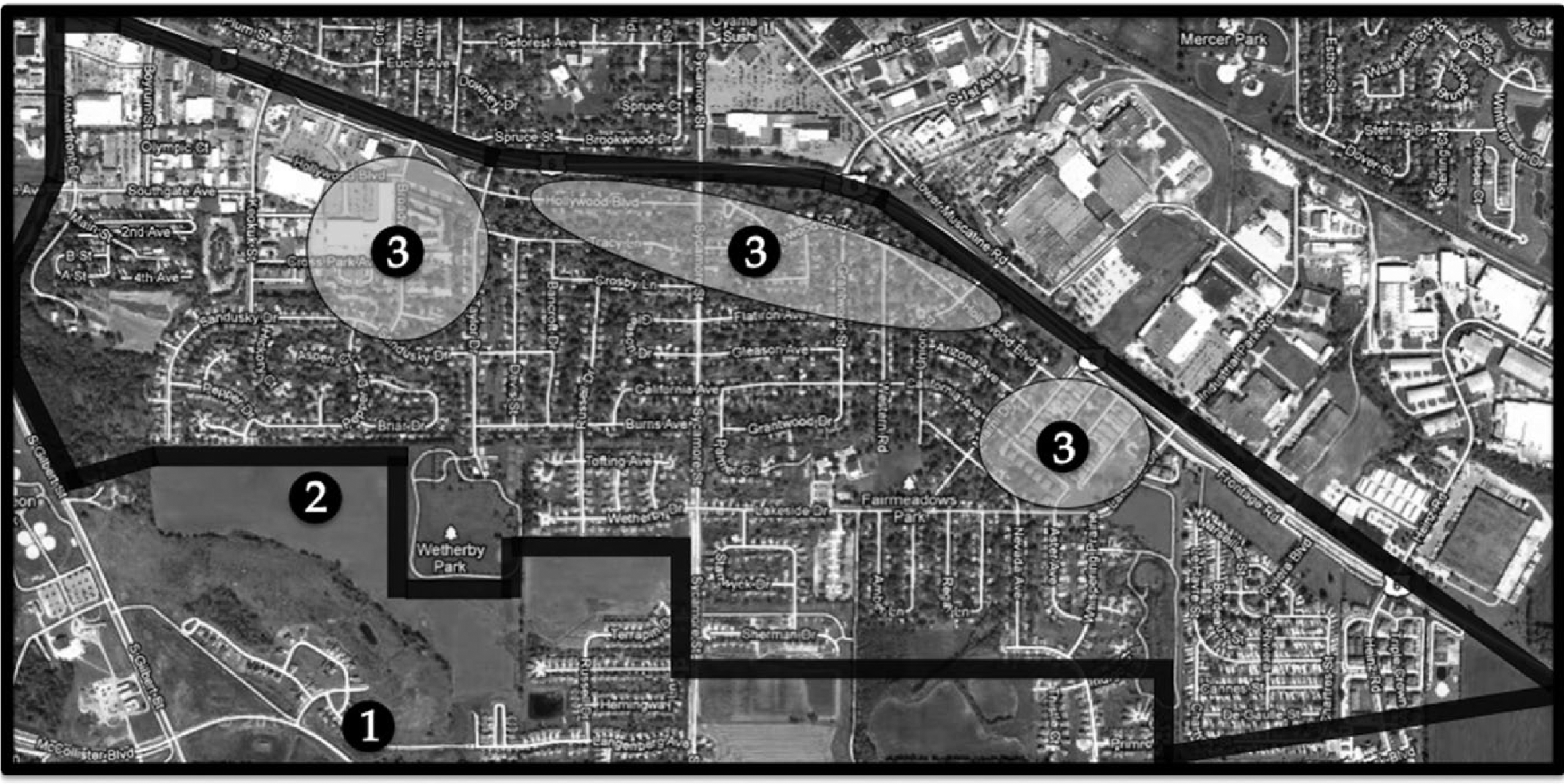
The three Southeast Sides. © Robert E Gutsche, Jr.
The first Southeast Side – identified in Figure 2 by a solid line (numbered 1) – stretched several blocks above Highway 6 to Court Street at the north, South Gilbert Street at the west, and to the city borders on the south and east ends. Participants said that this Southeast Side contained more businesses and economically and racially pluralistic residential neighborhoods. A second Southeast Side – outlined with a solid line (numbered 2) – focused on neighborhoods bordered at the north by Highway 6, at the west by South Gilbert Street, and by cornfields and city parks at the south. The eastern edge for this version of the Southeast Side seemed to appear near a trailer park and elderly care facility. This version of the Southeast Side, participants said, was considered to include more low-income housing and more pockets of racial and ethnic minorities.
A third Southeast Side was comprised of three separate locations (each numbered 3). Locations within this third Southeast Side included the Dolphin Lake Point Enclave apartments (formerly the Lakeside Apartments) near Lakeside Drive at the eastern edge of Highway 6. A second location included a stretch of Hollywood Boulevard between the Dolphin Lake Point Enclave apartments and the Broadway Condominiums on Broadway Street. The Broadway Street Neighborhood Center (BSNC) near Cross Park Avenue, which provides residents with preschool, parenting classes, tutoring, clothes, and food, represented a third location.
All journalists and officials said that the third version of the Southeast Side ‘is what the public means by the Southeast Side’ in that BSNC clients carry negative stigmas associated with Southeast Side neighborhoods. 4 While this particular exercise helped identify potential residents for this study, it also led to an understanding of just how close the ideological place-making process was for both the journalists and officials. The ramifications of this ideological connection should not be understated and is further explored in this study’s conclusion.
While this application of mental mapping revealed a resonance among journalists and officials as to the Southeast Side’s multiple meanings, a deeper reading of place-making was needed to explain the layered meanings of place being assigned to the Southeast Side by including interpretations of the city by residents at the center of the Southeast Side construction, which is discussed next.
Identifying Residents
Because journalists and officials identified clients of the Broadway Street Neighborhood Center as epitomizing the Southeast Side, I selected the BSNC as a site to conduct interviews with residents, which informed mental mapping below. I spent several hours within one week at the center (in addition to other time I spent as a journalist and researcher in the neighborhood over the course of 3 years). In the end, 17 residents agreed to participate in the study, and 5 declined. All residents identified as black, 10 as women.
Explicating Mental Maps
All participants – journalists, officials, and residents – were asked to draw maps to identify and explain natural or manmade geographies in Iowa City. 5 By asking them to describe their maps as they drew them, together we were able to identify evidence of different concepts of place and with it of ‘story’, which extended to authority, power, and social and cultural barriers in Iowa City. To do so, I first encouraged participants to see these maps as drawings that told people where they went in the community and what they knew about different parts of the city.
I asked participants to feel free to think of these more like drawings than absolute representations of space with scale and proportion (Johnson, 2007). While I asked participants to identify where they lived, I did not encourage them to identify any other items or locations on their maps. Participants were asked to draw all places in Iowa City, not just ones where they felt safe and considered themselves most knowledgeable; participants were encouraged to also draw both the areas where they had been and where they had not. When participants finished their maps, I asked them to describe what they had drawn and to tell me what types of people they thought lived in different neighborhoods, who enters and exits the spaces, and what they think happens in those spaces.
Once all maps were completed and collected, I turned to Wood (2010) and Cloke et al. (2004) to perform a critical analysis of mental maps. Wood writes that maps begin as empty, blank spaces that are either filled or left void, the reasons for which explain how one interacts with a specific environment and can be understood as story through semiotic analysis. Cloke et al. (2004) employ a Geertzean (1973: 308) approach of ‘thick description’ to read maps that ‘emphasizes the complex layers of meaning that can attach to what are often apparently simple social behaviors’. More specifically, Cloke et al. (2004) suggest cartographers and geographers become ‘insiders’ to study culture by moving past performing a mere analysis of place representations and interviews, but by allowing participants to speak for themselves and contribute to the researcher’s analysis. 6
In this way, mental maps revealed how participants experienced Iowa City, assigned meanings to various geographies, and – most importantly – constructed stories about the Southeast Side. Their maps, then, became visual narratives through which participants explained to me dominant and counter narratives and the degree to which journalists incorporated or rejected alternative explanations of place. Below, I briefly discuss three major themes that emerged from using mental mapping as methodology.
Mapping Stories of Mobility
First, mental maps were helpful in revealing the role of social and physical mobility in the city that influenced the stories participants told about the city and had access to. Exploring participants’ ability to traverse the city and enter or exit particular areas through access to transportation or with social power helped me to understand how social roles influenced the ability of journalists and officials to form similar, dominant stories that did not include perspectives from residents.
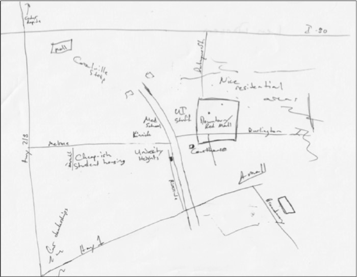
For example, while journalists and officials also drew roads on their maps – broad sketches of roadway and streets that lead to neighboring cities, such as by Jeff, a reporter for the Press-Citizen – residents focused much more on the roads themselves, drawing them wide and crowded with traffic (Figure 3). Residents, such as Lisa (Figure 4), however, drew details about her home, including a shortcut to her child’s elementary school that cuts through a grove of trees: ‘I like walking down the block and not feeling like you’re going to die’, she said.
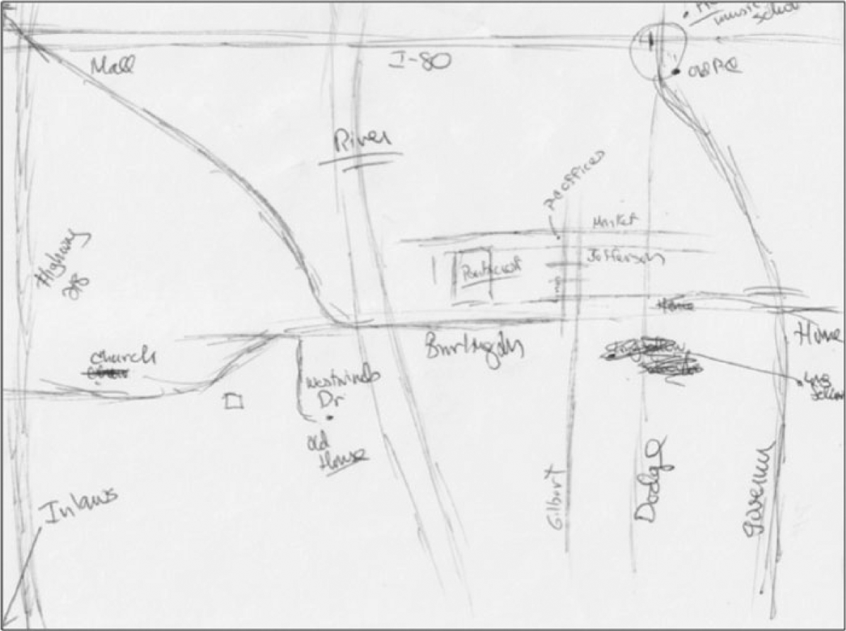
Jeff’s map, reporter.
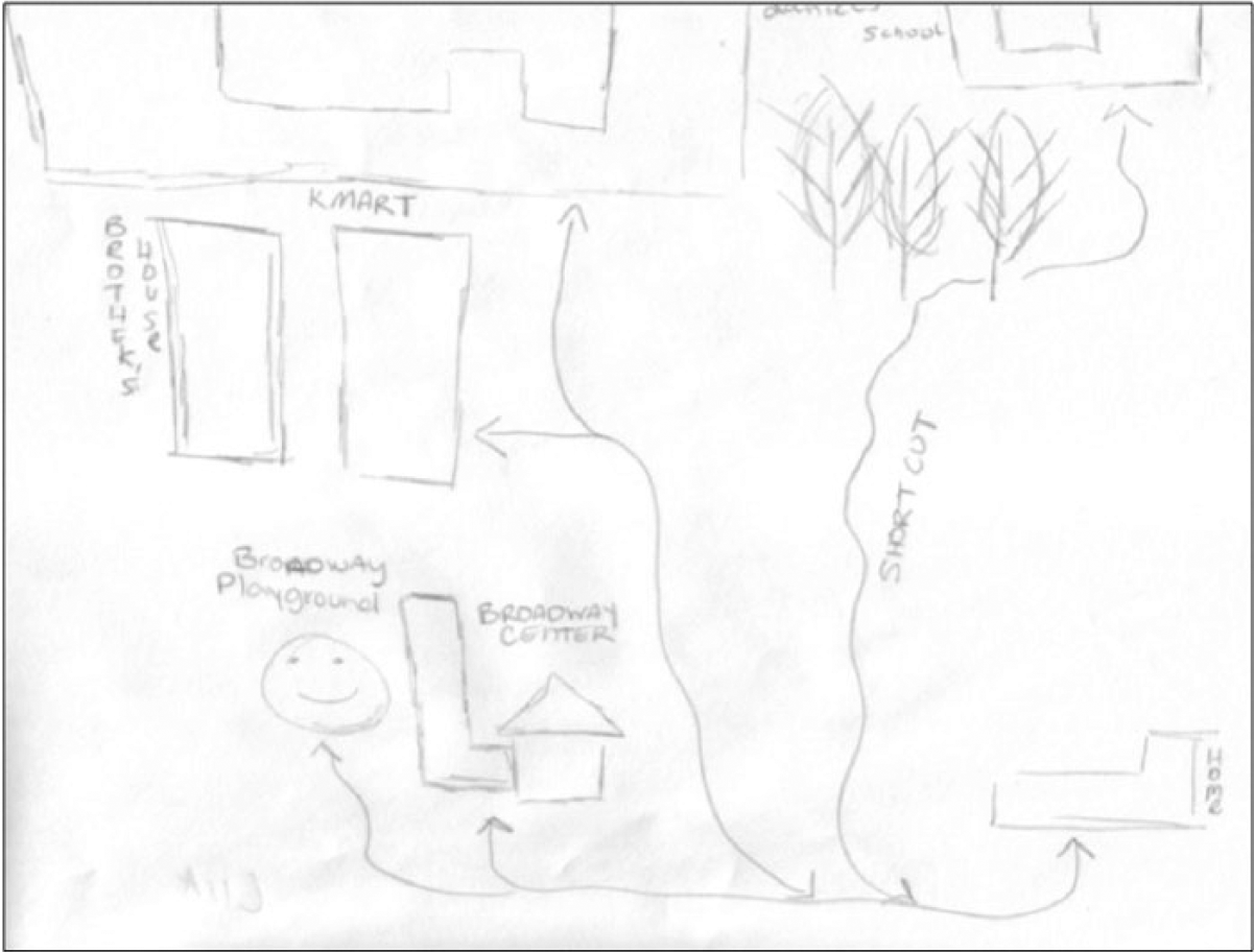
Lisa’s map, resident.
Interestingly, all journalists and officials included the Iowa River, which cuts through Iowa City, and defined it as a geographic feature that defines the city, while only 1 of the 17 residents included it; most residents said that they did not know about the Iowa River, where it was, and that it was not an important part of their lives. Such a striking comparison reveals how drastically residents, journalists, and officials experience and define the city and showed commonalities in ideologies and experiences among communities of journalists, their sources, and neighborhood residents and how mental mapping as methodology helped participants articulate their interactions with city spaces.
Drawing Knowledge of Place
Second, participants’ maps showed the spaces they frequented that contributed to personal knowledge of city geography and those places upon which they relied on dominant narratives and stories from others to describe and explain social conditions and environments. Understanding where – and why – participants spent time in particular parts of the city and not others helped me understand how personal experiences and stories of ‘urban spaces’ or the ‘Southeast Side’ contributed to constructing dominant and counter narratives of southeastern neighborhoods.
Through mental mapping, officials and journalists identified the same city spaces where they sought sources and information for news, in part because they spent most of their professional and personal time in these spaces – those near government and other opinion leaders in the downtown and the university areas. This mapping, therefore, also showed the spaces which journalists and officials found un-newsworthy in that they left these as empty spaces on their maps of which they were not personally familiar. Officials and journalists, then, filled in these blank spaces, particularly in their southeastern portions of their maps, with explanations from dominant narratives of urban spaces rather than stories from personal experiences or the Southeast Side that may challenge the place’s dominant characterization.
As Len (Figure 5), a reporter for The Gazette, said: You walk through the street and you see more black people … I think there is a lot of racism still, you know. That’s no secret. Like, you grow up in a town of 500 or 5,000 in Iowa like most people around us did and you never saw black people except for on TV.
Len’s map, reporter.
Conversely, residents seemed to represent city spaces as being fearful for them. For example, Tony, a Southeast Side resident, drew a map that reflects his feelings of isolation (Figure 6). By showing only the places he goes – his new home in the neighboring city of Coralville (‘CV’), his uncle’s house (‘U’), the Broadway Street Neighborhood Center (‘NC’) and the warehouse where he works (‘W’) – Tony said that he tries to ‘stay at home’ to avoid police and longtime, white residents who he thinks would discriminate against him for being black.

Tony’s map, resident.
Residents who described other spaces throughout the city as off-limits to black residents from the Southeast Side challenges city descriptions by officials and journalists that the downtown and university spaces were most welcoming and central to the city’s identity.
Sketching Social Barriers
Third, maps helped participants communicate ideological meanings behind space and place by drawing boundaries represented by lines or by the point of where drawing starts and stops. Maps show – and the mapmakers explained – philosophical and social barriers that get at the root of the degree of difference between dominant, mediated stories of the Southeast Side and stories from residents about their neighborhood. For instance, while officials and journalists marked the downtown and university in boxes as safe places, they separated themselves from the rest of the community, contributing to descriptions of the Southeast Side as ‘other’.
Journalists and officials also revealed shared dominant place-making processes and showed how the two groups reinforce each other’s explanations of city geography. For example, both Fred, a school official (Figure 7), and Roger, a journalist who covered Iowa City schools (Figure 8), mapped the city by schools and turned to student demographics collected by the school district to describe and explain social conditions in Iowa City neighborhoods, based, in part, on students’ socio-economic status.
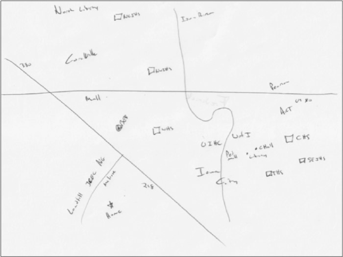
Fred’s map, official.
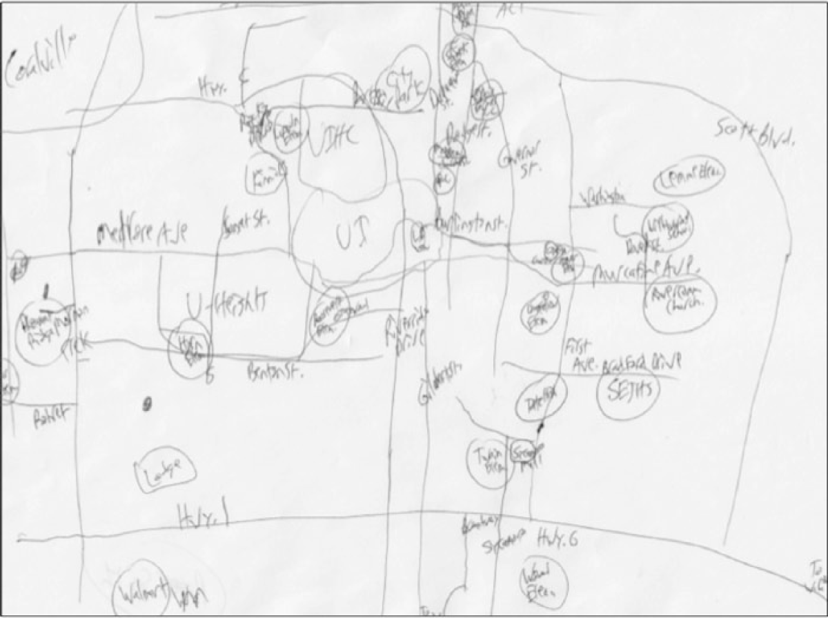
Roger’s map, reporter.
Residents, on the other hand, including Sandra, tended to draw specific elements of their neighborhoods that indicated notions of home (including smiley faces) but consistently drew and explained Highway 6, which borders the Southeast Side, as a means to keep blacks from entering into the rest of the city (Figure 9).
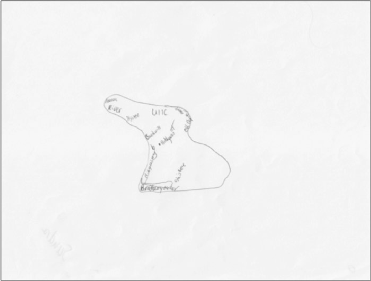
Sandra’s map, resident.
For many residents, the highway is a physical boundary that represents a border that shows ‘where blacks live’ and takes a prominent role in their maps, sometimes shown with traffic and as a wide landmark between their neighborhood and the rest of the city. Sandra’s map also shows her limited exposure to the rest of Iowa City, in part because of her reliance on public transit that is represented as a small, tight route around the city in the center of her page. Sandra said that even if she were able to move around town easier and visit more places, people would not want her in their neighborhoods or downtown: ‘People portray this place (the Southeast Side) as bad’, she said. ‘They are afraid of a lot of African Americans over here.’ By and large, journalists and officials did not show or describe explicit physical barriers from moving about the city as residents did; however, their stories revealed how the choices that they make about where to go and where to avoid contributed to their place-making, particularly about places they did not personally visit.
Discussion and Conclusions
This study focused on mental mapping as a qualitative, participatory method used for explicating interaction between space and ideology in terms of how geography is discussed in the news and here contributed to a larger research agenda that explores how journalists characterize place. In presenting this study, I considered news and notions of geographic place as social and cultural constructions and presented the data and methodology not as an all-encompassing explanation for how newsworkers characterized the Southeast Side, but as an example of how mental mapping serves as visual communication and a methodology that provides participants with an opportunity to become involved in research.
Asking people to recreate place in a map and to express their maps’ meanings attempts to bridge what ethnographers have struggled with – the idea of writing from ‘here’ about people who are ‘there’ (Denzin, 1997; Lewin, 2006; Soja, 2010). Scholars who use mental mapping may also be able to spur social action by ‘listening to voices’ (Cloke et al., 2004: 30) of those who are being studied, in this case, the marginalized and silenced voices of Southeast Side residents.
More specific to journalism studies, mental mapping informed my understanding of how social roles influence participants’ interpreted city spaces, thereby influencing what is considered authoritative and informed explanations of neighborhood conditions. Mental maps were especially helpful in identifying physical and philosophical boundaries that demarcate real and perceived social and cultural territory (Monmonier, 1996; Wood, 2010) and led to a deeper understanding of news coverage of a city, particularly in terms of how journalists and those they cover seem to live in very different ways in the same city, rarely crossing paths.
The mental mapping exercise by journalists and officials in which they identified the same geographies and meanings of ‘three Southeast Sides’ is a good example of the interconnectedness of the interpretive communities of journalists and officials (both local governmental leaders and police). While the process began as a way to explicate the complex and layered meanings of place among participants, the exercise identified the degree to which officials and journalists operate in a shared interpretive community (Berkowitz and TerKeurst, 1999; Zelizer, 1993), specifically in defining place and embedding ideological constructions within the place-name.
Indeed, while describing the multiple versions of the geography, participants even acknowledged how their consistent and continued use of the ‘Southeast Side’ label propagated particular ideologies of place. Journalists seemed to recognize the dangers of using the ‘Southeast Side’ place-name, often in phrases of ‘I know about that place,’ and then describing the Southeast Side either as ‘mostly black’, ‘crime-ridden’, or ‘poor’. However, the use of that term by both officials and journalists seemed acceptable and a legitimate means of communicating shared meanings of that place.
A finding that social elites such as journalists and officials share similar language and interpretations may not appear, on its face, to be unexpected. However, mental mapping in this case served as a means to identify the multiple levels of those shared ideological constructions in creating the Southeast Side and opened opportunities for residents to resist and counter mainstream explanations of place by producing artifacts that can be shared and explicated across audiences, a portion of which this project continues to examine.
In the end, this study suggests that scholars adopt a notion of news place-making as an understanding of the ideological (and practical) work journalists (and their sources) do in shaping dominant understandings of geography. Approaching place as an ideological project – as a process embedded with applications of power in what geographies are defined, how they are defined, and who defines them – contributes to an awareness of how place-making holds purposes of social control through stereotyping.
Therefore, journalism scholars should consider the extent to which current notions of the interpretive community operate within the field by extending the notion beyond a group of shared experiences and ideologies that start and stop with those labeled as journalists. In this study, officials and journalists were shown to operate as a second-level interpretive community in that they shared common values, experiences, and power to construct geographies in ways that they saw fit. This collaboration and interaction of shared information and interpretations appeared to extend the power of place-making regarding the Southeast Side beyond the newsroom and empowered particular sets of officials (while excluding others) in shaping mediatized place – and its people.
News place-making, in which geography is selected as the ideological focus of journalistic forms of social construction, could serve as a means to explore cultural interactions and functions of different spheres of the journalistic communities. My hope is that this news place-making and mental mapping as a visual medium can inspire and influence citizens, journalists, and scholars to further explore the social implications of narrow, dominant representations of geography – and its people – with the intent to uncover elements of power and inequalities of geographic representations in the news.
Footnotes
Acknowledgements
Funding
This research received no specific grant from any funding agency in the public, commercial, or not-for profit sectors.
Portions of this paper were based on research that received the Gene Burd Urban Journalism Research Prize from the Urban Communication Foundation and the Journalism Studies Division of the International Communication Association in 2013.
Notes
Biographical Note
ROBERT E GUTSCHE, Jr is an Assistant Professor in the School of Journalism and Mass Communication at Florida International University. He is the author of A Transplanted Chicago: Race, Place, and the Press in Iowa City (McFarland, 2014). His work on the journalistic interpretive community and new myth has appeared in Journalism Studies, Journalism Practice, Journalism & Mass Communication Studies and other journals.
Address: School of Journalism & Mass Communication, Florida International University, North Miami, FL 33181, USA. [email: