
Abstract
This article – drawing upon the archives of the London publisher John Murray – addresses the narration of landscape in 19th century printed accounts of travel and exploration. The geological work of the earth scientist Charles Lyell, and the textual and cartographic investigations of the scriptural geographer Edward Robinson, are used to examine the construction of narrative as a question of inscriptive practice, rhetorical desideratum, and interpretative strategy. We show how, with specific audiences and purposes in mind, and with Murray’s redactorial influence at heart, Lyell and Robinson cast their accounts in particular ways in order to satisfy expectations of scientific rigour, literary form, authorial credibility, and bodily encounter. The accounts – one by a scientist facing revelation in nature’s wonder, the other and by a theologian reading landscape scientifically in order to ‘prove’ scriptural truth – contribute to our understanding of the geographical dimensions of the relationships between science and religion in the 19th century. In addressing the complex connections linking author, publisher, and audience in the production of landscape narratives, the paper highlights the importance of epistemological matters in examining the making of geographical narrative, addresses the value of publisher’s archives in geographical research and illustrates how and why authors (and publishers) chose to put their written accounts to order in the ways they did.
Keywords
Introduction: travel texts and narrative form
As matters of genre and of narrative form, printed accounts of travel and exploration have been scrutinized by scholars of literary studies as well as by geographers. 1 The travel text as a mode of narration has been shown to share much in terms of rhetorical and discursive construction with the novel – the traveller as protagonist, the itinerary as plot. 2 As a structuring device for works of travel, narrative is sufficiently commonplace – at least from the mid 18th century – that the terms ‘travel text’ and ‘travel narrative’ may occasionally appear synonymous. Yet, while travel texts share ‘some of the attributes of the novel’, most particularly in terms of plot and narrative trajectory, the various written forms they assume – epistolary exchange; geographical itinerary and gazetteer; political, economic, or scientific discourse – mean that, much like the post-modern novel, they ‘persistently compromise’ the pretence of temporal order with ‘digression, excursus, and compilation’. 3
Historians of geography have made clear, however, that narrative in books of travel is not simply a means by which the written text is put to order in translating a traveller’s movements across space into a chronologically-sequenced story. Travel narratives are themselves works of literary practice, even as they reveal and reflect travellers’ interpretative strategies. The study of travel narratives can reveal authors’ inscriptive procedures and their (and their publishers’) decisions about the representation of the self and other, of landscape and authorial experiences in the field. 4 In both literary and epistemic senses, narrative is at once a process and an act of translation – part of the practice of ‘rendering the foreign into familiar terms’. 5
The study of travel writing thus offers an important means by which narrative as a strategy for the depiction of landscape can be understood as more than, simply, reading the geographical content of the text. Given that travel writers use narrative to tell stories about landscape, and to recount their journeys through it, narrative can be seen as descriptive and analytical – literary form and investigative technique. How travellers choose to narrate their encounter with landscape can be seen to reflect judgements about audience expectation, about the intended function of their text, and about authors’ desires to demonstrate credibility through their writing. 6 For one commentator, landscape is the ‘tension between proximity and distance, body and mind, sensuous immersion and detached observation’. 7 As the example of travel writers make clear, writing about landscape – that is, narrating the passage across it, and the experience of being in it – is also a matter of tension: one of the hard-to-resolve distinctions between the embodied experience of landscape and its representation in text and image. This fact can be further complicated by the aesthetic and literary cultures at work in given times and places, such as those conventions of the Romantic era which influenced the depiction of landscape variously in emphasizing the aesthetic principles of the picturesque and the sublime. 8
This paper examines how different travellers have negotiated these tensions, how they narrated their encounter with landscape, and how their strategies of textual representation varied in relation to the demands of scientific rigour, literary form, geographical utility, and the requirements of publishers and audiences. Our concerns are with two near-contemporary 19th-century travellers and authors – the geologist Charles Lyell (1797–1875), a British earth scientist in North America, and Edward Robinson (1794–1863), an American scriptural geographer in the Levant. Lyell’s work in North America, and Robinson’s investigations in the Holy Land, dealt with landscapes that were by turn spectacular and sacred: the one sought nature’s majesty in sites of scientific revelation, the other correspondence between landscape and the scriptures in sites of biblical truth. How Lyell and Robinson chose to narrate these landscapes was not simply a function of genre, nor was it a matter of different geographies or ends in view. It had to do, we argue, with travel writing as questions of different inscriptive practice, of the publisher’s editorial mediation, and of the authors’ and publisher’s thoughts about the audiences for their work.
The concerns of Lyell, the earth scientist, and Robinson, the practising theologian, with narrating landscape may also be used to cast light upon contemporary debates concerning the connections between science and religion – with how the world could be ‘read’ or narrated, as it were, for clues to support one view or another. Our objectives in addressing these two different authors, operating in two different parts of the world, are thus threefold. First, we use their work to explore the nature and making of in-the-field narrative writing. Second, we point to the value inherent in publishers’ archives in understanding the construction of travel narratives, and look at the involvement by the publisher in shaping the material form of these books. Third, where debate on the nature of the relationships between science and religion in the 19th century has been dominated by historical perspectives, we point to the importance of geographical perspectives and, in so doing, to the value of interpreting travel narratives (and the processes of their making) in relation to work in book history and the history of ideas increasingly concerned with the spatial dimensions of text and thought. 9
Lyell’s and Robinson’s narratives were both issued by John Murray – Britain’s leading 19th-century publisher of accounts of travel and exploration. 10 John Murray’s Romantic-era travellers spanned the globe, and in accounts addressed variously to scientists, politicians, merchants, and armchair travellers, revealed landscapes which were often geographically remote and epistemically unfamiliar. Murray and his travellers thus sought – as a function of authorial fidelity and editorial judgement – to establish a correspondence between the experience of landscape in the field and its representation on the page, and so to collapse the geographical distance between reader and landscape. The production of these narratives was further predicated upon authors’ individual judgements as to style and function and upon Murray’s editorial role in shaping books’ content and in cultivating audiences. 11
The Murray firm’s editing and publication of travel narratives has been examined, for example, with reference to the amendment of the narratives of the polar explorer George Back in the 1830s. Back was anxious to get into print an account of what, in effect, had been a failed expedition. Murray required that what Back called his ‘rough Journals, made from each days [sic] occurrences’ be put to better order – that is, be re-arranged as to chronology and thematic significance – if they were to be published so as to attract interest. 12 Similarly, the West African explorer and Murray author, Hugh Clapperton, undertook his in-the-field writing in two formats, a log and a journal, and altered the second from the record of the first to produce a ‘fair copy’ of his travels which was further amended by Murray’s staff before appearing in print. Another narrative of travel in West Africa – one written by the brothers John and Richard Lander – was, under Murray’s instruction, edited by an official from the Admiralty in an effort to improve perceived flaws in its style and scientific credibility. 13 Murray was far from alone in transforming authors’ words: the Edinburgh firm of Blackwood made major changes to the narrative of the African explorer John Hanning Speke in order to reflect the publisher’s expectations of readers’ interests concerning the innate civilization of Africans. 14 In books on South American travel, too, Murray manipulated the market and managed different authors’ words to create different forms of travel narrative. 15 Because Murray (and other publishers) thus amended authors’ words, and because readers could take different stances in interpreting the printed text, we must take seriously the ways in which narratives of travel and landscape were produced (and by whom) and how particular descriptive techniques and rhetorical approaches were used to secure and demonstrate authorial credibility and textual fidelity. 16
The narration of landscape by Lyell and Robinson depended upon various and complex connections between author and publisher, and in Lyell’s case, upon satisfying readers’ desire for ‘the “Eureka Moment”’ – the point of ‘instant, astonished recognition’ which typified the ‘Romantic notion of … discovery’. 17 For Robinson, narrating the landscape of the Holy Land required fidelity to the word of God. These connections between author and publisher, between narratives of landscape as practices and sites of scientific and scriptural revelation, are central in understanding the texts of Lyell and of Robinson, the wider intellectual contexts in which they were set, and the local practices through which their work was undertaken, produced, and received.
Narrating deep time and landscape as spectacle: Charles Lyell at Niagara
At the turn of the 19th century, earth scientists held, in the main, to one or other of two interpretative positions concerning the planet’s formation and age: that the features of the earth’s surface were the consequence of either dramatic, recent events (catastrophism), or were the culmination of gradual processes operating continually over long periods (uniformitarianism). Resolution to this debate came as a consequence of fieldwork. 18 To apprehend the earth’s surface processes – to read the landscape for clues as to its geomorphological history – meant seeing for one’s self, or, failing that, of reading the accounts of trusted observers. 19 In this peripatetic profession, one of the most travelled observers was the lawyer-turned-geologist Charles Lyell.
Lyell’s scholarly reputation as a geological theorist, and practical traveller, had been secured through his three-volume Principles of Geology (1830–33) wherein he presented evidence for an older Earth than was then held by many natural philosophers, and advocated the principles of uniformitarianism to explain his claims. 20 Lyell undertook numerous travels in Europe and North America in the course of developing his uniformitarian perspective. Although his text was received with enthusiasm, and would eventually become scientific orthodoxy, it was not alone sufficient to disprove catastrophism. For that reason, Lyell continually sought additional proof in the field. In 1841, he accepted an invitation to deliver a series of lectures at the Lowell Institute in Boston. His dozen lectures, which attracted audiences in excess of 3,000 people, earned him the sum of $2,000, and he used this money to fund a geological reconnaissance of eastern North America – a continental laboratory in which he might test and refine his ideas. 21 What he wished to see, more than anything else, was Niagara Falls. 22
Since the Falls at Niagara had been brought to the attention of the European imagination towards the end of the 17th century, they had been a source both of subjective awe and scientific curiosity. 23 The Falls functioned ‘as a device for reverie’ and, for Lyell, as a geological calendar by which uniformitarianism might be tested and measured. 24 What was at question was how long the Falls had taken to recede from their nick point on the Niagara Escarpment near Queenston to their present position. For Lyell,
the Falls of Niagara teach us not merely to appreciate the power of moving water, but furnish us at the same time with data for estimating the enormous lapse of ages during which that force has operated. A deep and long ravine has been excavated, and the river has required ages to accomplish the task.
25
In an effort to reconstruct the retrograde progression of the Falls, Lyell surveyed the geology and sedimentary deposits on both sides of the river and interviewed the area’s inhabitants who were able to explain to him how, in the course of their lifetimes, the Falls had gradually and perceptibly receded. Each investigation took him further up river, closer to the Falls, and also allowed him to ‘peel back’ successive layers of the earth’s surface to reveal its structural geology.
Lyell’s landscape vision of Niagara was captured in the frontispiece (Figure 1) to his Travels in North America (1845). This idealized bird’s-eye-view placed the Falls in geographical context, but it also revealed an otherwise hidden sub-surface geology through which the river had patiently excavated its course – taking, Lyell calculated, 35,000 years to do so. Lyell eventually reached the Falls on a clear, late-August morning, catching his first glimpse at about three miles distance: ‘The sun was shining full upon them – no building in view – nothing but green wood, the falling water, and the white foam. At that moment they appeared to me more beautiful than I had expected, and less grand’. 26 When compared with other contemporary British visitors’ reactions upon their first view of Niagara, Lyell’s response – which placed emphasis on the Falls’ picturesque qualities rather than their sublimity – appears somewhat muted. The awestruck reveries of two near-contemporary travellers, both Murray authors, are more typical, but arguably demonstrate an affectation of wonder – the correct emotional response to a sublime spectacle commonly advertised as ‘the most splendid sight on earth’. 27 The military officer and adventurer George Head, for example, suffered a form of sensory overload: ‘With the strongest anticipation of a spectacle, the very grandest of Nature’s efforts, I was, on my arrival, utterly unprepared for the splendour of the reality … Chaos seemed before me! My ears were confounded; my sight was dazzled’. 28 The actress, Fanny Kemble, was similarly stunned: ‘without speaking a word, [a travelling companion] dragged me to the edge of the rapids, to the brink of the abyss. I saw Niagara. – Oh, God! who can describe that sight?’. 29
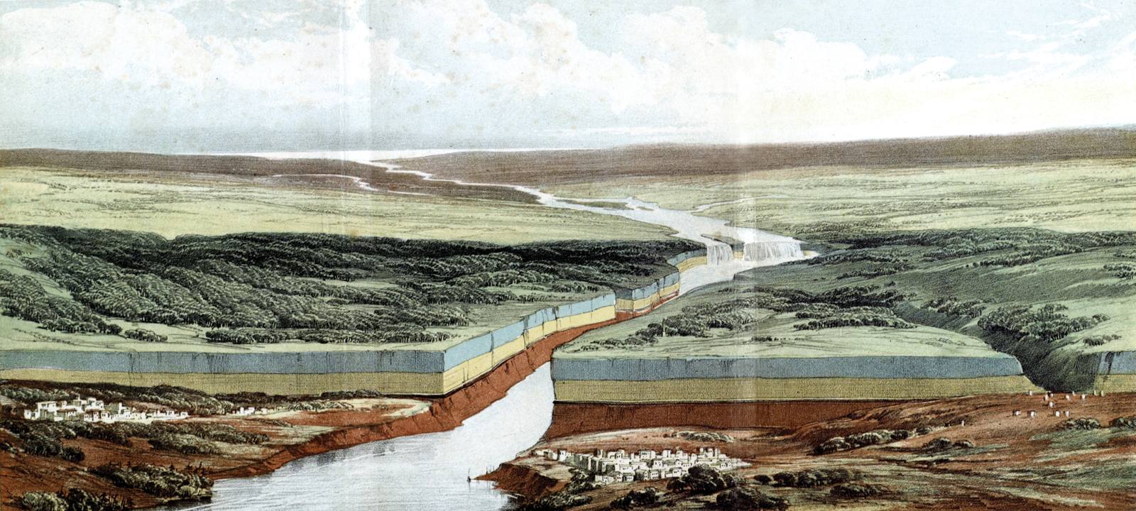
‘Birds-eye view of the Falls of Niagara & adjacent country. Coloured geologically’. Frontispiece to Charles Lyell, Travels in North America (1845).
Unlike Head and Kemble, whose physical proximity to the Falls left them simultaneously thrilled and bedazzled, Lyell’s first sight of Niagara occurred at a distance. This geographical separation from the spectacle can be seen to account, at least in part, for his initially under-whelmed reaction. The different emotional responses which Head, Kemble, and Lyell documented were a consequence also, however, of the type of narrative which they sought to construct. Head’s Forest Scenes, an account of a winter’s journey from Nova Scotia to Upper Canada and a four-month residence on the forested shores of Lake Huron, sought to offer a heroic narrative of arduous and manly travels. It was a text, however, that also meditated – as Henry David Thoreau would later famously do in Walden (1854) – on the author’s emotional and subjective response to ‘forest life’ and the natural environment. 30
Stylistic inspiration for Head’s book came, in part, from a volume of adventuresome travels in South America – Rough Notes Taken During Some Rapid Journeys Across the Pampas and Among the Andes (1826) – which his brother had published to popular acclaim with Murray four years previously. 31 It is certain that Murray would have wished Forest Scenes to match Rough Notes’ literary success – the latter book was the most successful account of travel in southern South America to be published in Britain during the 1820s. 32 The critical response to the publication of Forest Scenes suggests that Head succeeded in emulating his brother’s ‘individuality of manner, spirit of description, and truth of nature’. 33 One periodical noted that ‘The brothers…resemble one another in straightforwardness of style and promptitude of manner’. 34 At least one publication found fault, however, with Head’s ‘grandiloquence in describing the Falls of Niagara’, dismissing the offending passages as ‘an excrescence on the familiar and unambitious style in which the volume is generally written’. 35
Head’s occasional grandiloquence notwithstanding, Kemble’s Journal was emotional in an altogether different register. At turns gossipy, ‘frank and tactless’, Kemble’s account detailed her largely unfavourable impressions of American society and culture. 36 Although Kemble’s volume had not originally been written for public consumption, Carey, Lea & Blanchard, a Philadelphia publishing firm (who subsequently issued the book in cooperation with Murray), saw in the text an opportunity to replicate the sensation which Frances Trollope’s caustic Domestic Manners of the Americans (1832) had provoked three years previously. 37 Kemble, who harboured literary ambitions and also required funds to ensure the security of an elderly aunt, agreed to the book’s publication. To whet the public’s appetite, certain salacious ‘pages of unauthorized galley proofs’ were circulated by the publisher in Philadelphia and picked up by national newspapers and quarterlies. 38 In an effort to mitigate the offence Kemble’s guileless text might cause to those who were mentioned in it, her husband saw to it that several sections of the book, along with most proper names, were redacted prior to its publication. This did little, however, to diffuse the ‘literary bombshell’ which the book represented. 39 For Head and Kemble, subjectivity, sensibility, and sensation were intrinsic qualities in their narratives – Head wished to convey an adventuresome spirit, Kemble to make a name for herself and thus to ‘further her career in belles letters’, Carey, Lea & Blanchard to create a sensation. 40
Lyell, by contrast, was aware that if his interpretation of the Falls’ developmental history was to be taken seriously as evidence in support of his uniformitarian position, he would be required, at least in some measure, to keep his subjectivity in check. It is unsurprising, therefore, that his representational strategy relied, in part, upon quantification and hoped-for objective description. Plain facts clearly ordered were the mark of a scientist’s discourse. Although Lyell’s narrative follows a superficial chronology – each chapter opening with a calendar date, as though it were a journal entry – there are occasions on which it departs from a temporal order to incorporate the author’s reflections (added at the time the book was revised for the press) on events that had previously, or would subsequently, occur – essentially flashbacks and flashforwards, or, in the language of narrative analysis, analepses and prolepses. 41
Lyell’s account of his encounter with Niagara opens with a prolepsis, wherein he indicates that his emotional and aesthetic response to the Falls would, later in the narrative, undergo a shift from under-whelmed to awestruck. From hinting at this imminent revelation, however, the narrative resumes a resolutely scientific character as Lyell resolves his sensory engagement into an objective, abstracted representation. In this literary mode, the aesthetic spectacle of the Falls could be reduced by Lyell to its practical elements in bald statements of fact:
The waters, after cutting through strata of limestone, about fifty feet thick in the rapids, descend perpendicularly at the Falls over another mass of limestone about ninety feet thick, beneath which lie soft shales of equal thickness, continually undermined by the action of the spray…against the base of the precipice.
42
As Lyell’s narrative prolepsis had made clear, however, he was to be gradually overtaken by his emotional and aesthetic response to the Falls. No longer picturesque, they became literally awesome. He explained it thus:
after several days, when I had enjoyed a nearer view of the two cataracts, had listened to their thundering sound, and gazed on them for hours from above and below, and had watched the river foaming over the rapids, then plunging headlong into the dark pool . . . I at last learned by degrees to comprehend the wonders of the scene, and to feel its full magnificence.
43
Lyell’s long residence at the Falls was, in his view, central to the perspective which he gained. In a letter to his father-in-law, Lyell spoke dismissively of tourists who ‘discuss the Falls in three hours’ before moving on to the next picturesque spot on their itinerary. 44 Time, and the absence of distraction, was crucial. The change in Lyell’s reading of the landscape at Niagara might be dismissed simply as the gradual recognition of its beauty that occurred to him once the business of geology had been put to one side, a consequence of continued residence there rather than a typical tourist’s transience. It might also, and more properly, be seen to represent a transfiguration on his part which prompted a state of reverie in which his observations on the Falls’ development came together with his geological philosophy in an almost dizzying revelation.
The Falls at Niagara were, for Lyell, ‘a chronometer measuring rudely, yet emphatically, the vast magnitude’ of geological periods, but they represented only the most recent in an unimaginable series of ‘antecedent revolutions’. 45 In contemplating the Falls’ long history against the inconceivable reaches of deep time – a notion still far from accepted in contemporary scientific and religious circles – Lyell turned in his narrative skywards for a suitable point of comparison:
No analogy can be found in the natural world to the immense scale of these divisions of past time, unless we contemplate the celestial spaces which have been measured by the astronomer. Some of the nearest of these within the limits of the solar system . . . are reckoned by hundreds of millions of miles, which the imagination in vain endeavours to grasp. Yet one of these spaces, such as the diameter of the earth’s orbit, is regarded as a mere unit, a mere infinitesimal fraction of the distance which separates our sun from the nearest star. By pursuing still farther the same investigations, we learn that there are luminous clouds, scarcely distinguishable by the naked eye, but resolvable by the telescope into clusters of stars, which are so much more remote, that the interval between our sun and Sirius may be but a fraction of this larger distance. To regions of space of this higher order in point of magnitude, we may probably compare such an interval of time as that which divides the human epoch from the origin of the coralline limestone over which the Niagara is precipitated at the Falls.
46
In a narrative sense, this cosmological reasoning is suggestive not so much of Lyell losing his grip, as it is of him gaining earthly perspective. The tension which previously seemed to exist between his objective description of the Falls and his emotional reaction to them is revealed to be almost the opposite – not an incompatibility, but an opportunity to recast the landscape as something other: as a telescope by which the remote regions of time might be resolved. This important transition in Lyell’s narrative had, however, to be negotiated carefully. The credibility of his account depended upon Lyell’s ability to outline a compelling scientific case while also demonstrating that his moment of revelation amid the spray of Niagara had been genuinely felt and that it was epistemically valuable. In appearing to vacillate between the robustly scientific and the linguistically oratorical, Lyell’s text mirrors his own effort to satisfy these twin measures of credibility while simultaneously avoiding the ‘hacknied phrases of delight and stereotyped notions of the sublime and beautiful’ that were seen, pejoratively, to characterize visitors’ descriptions of the Falls. 47
Rather than undermine his intellectual position, however, Lyell’s subjective response to Niagara – his reverie in its grandeur – became central to his understanding of the Falls’ position within the geological history of the region and to the communication of his uniformitarian interpretation to the book’s audience. Lyell’s contemplation of the Falls offered him a more profound and emotionally-engaging appreciation for the implications of deep time. As his concluding passage makes clear, however, the natural spectacle of Niagara was overshadowed by the wondrous, almost sacred prospect which geological time offered:
Many have been the successive revolutions in organic life, and many the vicissitudes in the physical geography of the globe, and often has sea been converted into land and land into sea, since that rock [over which Niagara cascades] was formed. The Alps, the Pyrenees, the Himalaya, have not only begun to exist as lofty mountain chains, but the solid materials of which they are composed have been slowly elaborated beneath the sea within the stupendous interval of ages here alluded to. The geologist may muse and speculate on these events until, filled with awe and admiration, he forgets the presence of the mighty cataract itself, and no longer sees the rapid motion of its waters, nor hears their sound, as they fall into the deep abyss.
48
Lyell’s narrative account of the Falls’ erosive action, and its implications for his understanding of deep time, was more than just purple prose. It was deliberately calculated to excite in his audience the feeling of being witness to a profound moment of scientific discovery. What Lyell, and by implication Murray, sought to achieve in the text was to capture a moment of epiphany. The significance of this trope to Romantic readers has been described by one historian in relation to the composition of Keats’s ‘On first looking into Chapman’s Homer’: ‘The geography of the earth, or the structure of the solar system, are in an instant utterly changed, and forever. The explorer, the scientific observer, the literary reader, experience the Sublime: a moment of revelation into the idea of the unbounded, the infinite’. 49 Lyell was aware that the success of this particular type of narrative construction would depend upon the careful balance of those elements of his account likely to be ‘of great popular interest’ against those ‘scientific details…and geographical & geological description … which would be dry to the general reader’. 50 This is not, we emphasize, a scriptural geology in the sense that others knew it at the time – seeing nature as a quasi-laboratory space for the confirmation of already-held views about the truth of scriptural accounts – but an attempt to cast scientific light, in proper narrative form, upon earth’s sequential history and, by implication, upon the truth of the written but unsubstantiated words of God. 51
When Lyell first approached his publisher John Murray (who had undertaken his Principles of Geology) with a plan to publish an account of his researches at Niagara, he envisioned a compact treatise of ‘100 pages’, to be submitted to The Edinburgh New Philosophical Journal. 52 Thereafter he would have ‘a certain number of copies printed for the American market’ by the New York firm Wiley and Putnam. 53 Whether or not this ambition was genuinely held by Lyell, or reflected disingenuousness on his part calculated to excite Murray’s interest in the project, is unclear. What is certain is that by 1844 Lyell, in consultation with Murray (who had assumed responsibility for the text’s publication), had extended his scope. He now aimed to produce an account of his North American travels in two volumes, which he estimated – in a reference to a recently-published sensational account of transmutation – would be ‘each of the size of the Vestiges of Creation’. 54 While it was necessary that Lyell’s geological narrative should be ‘adapted to the comprehension of the general reader’, an important element for Lyell and for Murray was the effective use of illustrations. 55
On leaving Niagara, Lyell had acquired that tourist staple – a souvenir daguerreotype of the Falls. He regretted the fact that the earliest visitors to Niagara had been unable similarly to record the scene, and to capture thereby a visual narrative of the Falls’ regression. As he lamented to one correspondent, ‘What would I give for a daguerreotype of the scene as it was 4,000, and again 40,000 years ago’. 56 The next best thing, in Lyell’s view, was to include in the published version of his text a facsimile of ‘the grand cataract … as it appeared in the year 1678’ when it was sketched by a Catholic missionary, Louis Hennepin. 57 Despite a degree of vertical exaggeration, and the erroneous inclusion of a sailing ship in Lake Erie, Hennepin’s sketch (Figure 2) was faithful enough to demonstrate that certain changes in the morphology of the Falls had occurred in the intervening 150 years. In this way, juxtaposed with Lyell’s own bird’s-eye-view, Hennepin’s sketch was employed to offer visual affirmation of Lyell’s narrative of landscape change at Niagara.
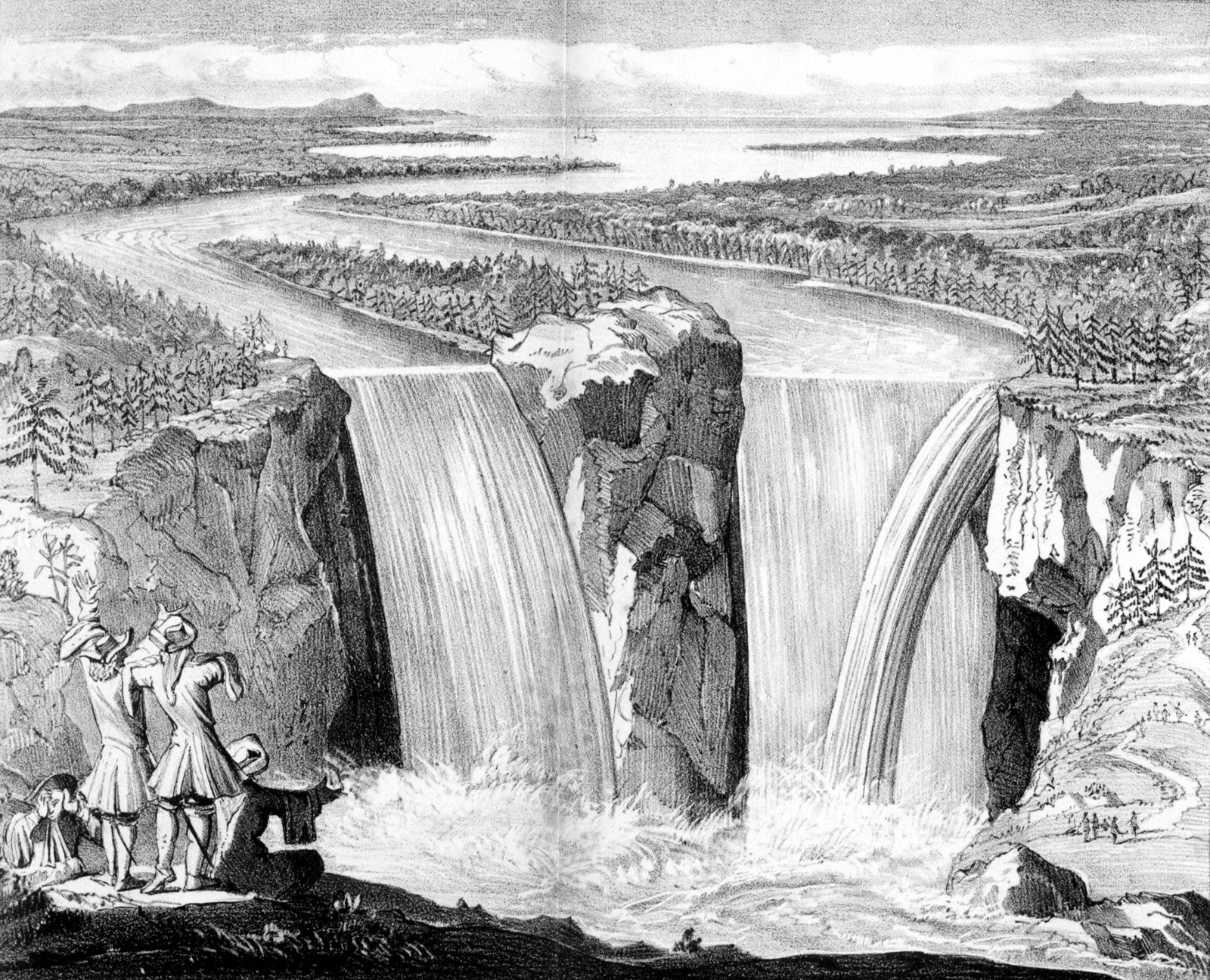
‘Fac-similie of a view of Niagara Falls, by Father Louis Hennepin. From the original Utrecht edition, 1697’, from Charles Lyell, Travels in North America (1845).
Murray, naturally, had a central role in facilitating and managing the book’s illustrations, assisting Lyell in selecting an engraver for the Hennepin facsimile (Hullmandel & Walton), and a colourist for the frontispiece (Day & Hague). 58 Given the fact that Hullmandel & Walton, and Day & Hague were then regarded as ‘fierce competition’, engaging both firms would have required tact and diplomacy on Murray’s part. 59 As a consequence of his position, Murray was able to procure for Lyell’s volume a map of North America which had been drawn the previous year for George Featherstonhaugh’s Excursions through the Slave States (1844). The map – which is recorded only as having been ‘prepared by the Person who lives in one of the Streets that opens into Holborn’ (most probably the cartographer John Arrowsmith), and engraved by J. & C. Walker – was adapted for Lyell’s purposes and coloured to show geological strata. 60 Despite these additions and amendments, recycling Featherstonhaugh’s map helped minimize the expense of the book’s publication – Murray’s ledgers record an expenditure of £8 for this task. 61 To Murray, use of another’s map in this way was sound business practice, and a reflection of the costs of map engraving. Featherstonhaugh, as a contracted Murray author, seems to have had no say in the matter. For modern-day researchers, such evidence cautions against uncritical assumptions about authorship and the need to be attentive to the circulation of content across and between different narratives of travel.
The critical response which greeted the publication of Lyell’s twin volumes in 1845 was ‘very favourable’ – some reviews were so fulsome in their praise that Lyell suspected them to have been ‘written evidently with a wish to help the sale, & not without tack for that object’. 62 The ‘agreeably mingled’ blend of scientific observation and social commentary which Lyell and Murray achieved in the text was singled out for particular praise – it being ‘sure to interest the intelligent reader’. 63 Lyell’s perspicacity, particularly as it related to his ability epistemically to penetrate the landscape and thus to narrate stories of its history, was commended: ‘His scientific habits have moulded his mind to the perception of hidden truths; have taught him that he who would arrive at right conclusions must not be content with the surfaces of things, but must look below to find their meanings’. 64 For The English Critic, Lyell epitomized the abstemious scientist – ‘patient of the toil exacted by the austere genius of inductive philosophy’ and ‘hard-working, sober-minded, well-disciplined’. 65
Lyell’s subjective experience at Niagara, and the revelation it engendered, did not, in the view of The Examiner, compromise his objectivity. As it was cast in that periodical’s account, the ‘spectacular scene’ had prompted a valuable and ‘new matter of elevated thought and grand reflection’. 66 Narrated in this way (in, that is, precisely the Romantic trope of discovery), Lyell’s experience at Niagara represented a moment of liminality – a threshold at which he was able to read the Falls’ landscape as a geological index of time and as an almost revelatory spectacle. Niagara was the site at which ‘the wonders of the antediluvian period were working out before his [Lyell’s] eyes’. 67 The narrative of his landscape encounter reads, thus, like a pilgrimage – the story of a ‘long personal quest to find a deeper understanding of reality’, as one historian of science has elsewhere characterized the work of geology in the field. 68 Landscape is central to this pilgrimatical trope; it is from a phenomenological ‘exposure to the geological features’ that Lyell was able to draw a more profound, indeed sacred, insight. 69 Just as others have cautioned about the simplicity of referring in historical context to ‘theology and science’ in essentialist terms, so the particularities of the connections between the two terms were importantly a matter of the narrative authority employed in detailing precisely how and where the two ways of reading nature were to be interpreted. 70
What Lyell sought at Niagara was additional proof of his uniformitarian perspective. What he got was something other besides: a new perspective on deep time, which emerged from his contemplation of the unremitting and gradual erosive work of the Falls. Lyell was transfigured by his experience in part because the tension which appeared to render his scientific and aesthetic readings of the landscape distinct and incompatible was resolved by a moment of reverie into an opportunity for insight. This is not simply to rehearse the idea that science is socially and spatially constructed. It is to suggest that subjectivity (in this case as a question of Lyell’s landscape perception) was implicated in, and necessary to, his conceptualization of geological time. In this respect, Lyell’s scenic and scientific gazes were together implicated in the production of his geological knowledge and his representation of Niagara Falls as a site in which the veracity of uniformitarianism was clearly (and wondrously) demonstrated. Niagara – a natural laboratory and a site of aesthetic reverie and geological revelation – was a landscape read and narrated as science and spectacle, of landscape and science as spectacle. The implications of this landscape narrative were clear: science is the new religion, and geology its prophet.
Narrating sacred landscapes: scriptural geographies of the Holy Land in the works of Edward Robinson
Charles Lyell sought scientific revelation from the Book of Nature. Others turned to the Book of Scriptures. In the 19th century in particular, widespread attention to the geography of the Holy Land was evident in a mix of travel writing, religious and literary studies, archaeological enquiry, and, notably, in the discourse of scriptural geography. As a genre, scriptural geography has long-running roots – evident in early Christian Biblical toponymics and in 17th- and 18th-century sacred and ecclesiastical geography. In the 19th century, scriptural geography emerged as a distinctive, popular, and widespread form of geographical enquiry concerned, in the main, to consider the surviving remains of Biblical sites, and the physical setting of the Holy Land, as the basis to Biblical exegesis and renewed faith in the Holy word. It did so because of developments in Christian textual criticism and following western ‘rediscovery’ of Palestine from the early 19th century. 71 Whist scriptural geology has been the subject of scholarly attention in relation to 19th-century narrative studies of the testing by science of religion, and vice versa, no such attention has been paid to scriptural geography as a narrative of religion read scientifically. 72
Aiken argues in his history of this geographical genre that while it had this common end in view, 19th-century scriptural geography had discernibly different forms at different times: a ‘didactic’ form ‘whose aim was to acquaint the reading population with the geographical context of the Bible’s stories’; a ‘polemical’ form wherein ‘Authors attempted … to use data from both the physicality of the landscape and its archaeological remains and the habits of its population to support their belief in the truth claims of the Book whose story was set in that Land’; and ‘contextual scriptural geography’, ‘a project about explanation and situation of the biblical text, using the methods of modern science and theological scholarship’. These ‘three orders of Scriptural Geography’ fell, roughly, into three periods: didactic before 1850, polemical between about 1850 and 1880, and contextual after 1880. 73 As illustrations of this three-fold typology and chronology, Aiken discusses, respectively, the work of Bishop Michael Russell, of the Rev. Professor Josias Leslie Porter, one-time Vice-Chancellor of Queen’s University Belfast, and of George Adam Smith. 74
It is not our concern to debate the merits of Aiken’s classificatory schema, nor his reading of Porter as a leading polemical scriptural geographer. It is our concern to examine the relationship between landscape and narrative in the work of this, hitherto overlooked, scriptural geographer. In turning to the Holy Land narratives of the American clergyman and author, Edward Robinson, who made two trips to the Holy Land, in 1838 and in 1852, it is clear that as a scriptural geographer, he had to deal with the problem of effecting correspondence between what as an author he saw, experienced, or was told by others, and what different audiences would find at once theologically credible and scientific as to its style and conduct in the field: his was a textual genre which depended upon seeing in the Holy Land’s geography confirmation of the Bible as the Word of God. For Porter, there was no one better than Edward Robinson. Writing to John Murray in 1856 over preparations for a Murray handbook on the Near East, Porter wrote ‘I wish I had Robinson’s new work, for he is the only man in whose accuracy I can depend; and his historical notes are invaluable’. 75
Porter’s view of Robinson’s importance and of his work is borne out by contemporaries in theological and in geographical circles: a commentary published shortly after his death noted that ‘His works on the Holy Land stand at the head of the literature of this subject, not only in this country [the United States of America] but in the civilised world’. 76 In addition to works of biblical scholarship, Robinson wrote three books on the geography of the Holy Land, each published by Murray. His Biblical Researches in Palestine, Mount Sinai and Arabia Petraea: A Journal of Travels in the Year 1838 appeared in 1841 (simultaneously in London, New York, Boston, and Halle), with later editions in 1856 and 1867. This book, and a related paper, was the basis to Robinson’s being awarded the Gold Medal of the Royal Geographical Society in 1842. Later Biblical Researches in Palestine, and the Adjacent Regions: A Journal of Travels in the Year 1852 was published in 1856, and his Physical Geography of the Holy Land in 1865. For Yothers, Robinson’s Biblical researches in Palestine ‘provides the most striking instance of the tendency of Holy Land narratives to mix widely disparate genres,’ because his account is coloured by ‘a strong Protestant polemic that leads him to cast doubt on the authenticity of sites venerated by Roman Catholic and Orthodox Christians while attempting to create a sacred key to the geography of Palestine that can be matched closely to the biblical text’. 77
If Robinson’s work was thus polemical and contextual, what is important in this context is how he sought to connect landscape and narrative, in his own texts and in relation to the Scriptures: for Robinson, ‘The ultimate verification of a site’s significance…must come from the biblical text’. 78 Robinson’s status as author and scriptural geographer was established in four related ways: by being in the field (credibility secured by immediacy); by particular methods involving instrumentation and cartography (epistemological procedures); by the support of other leading geographers and cartographers, in Britain and in Germany (warrant by association); and by negotiating with Murray over different editions of his work for different audiences (management of reputation, authorial and editorial).
Prior to publication of his 1841 book, Robinson presented a summary version of his first Palestine travels, which he undertook with the Rev. Eli Smith, to the Royal Geographical Society. 79 The bulk of this paper was topographical description but its detail, and the associated map, was praised by the leading German cartographer, Heinrich Berghaus:
The observations of these two travellers are so full and comprehensive, their notes upon the form and features of the country so exact and definite, that the geographer is in a situation, on the basis of these specifications, to construct a special map of the territory, which may perhaps leave little more to be desired . . . It is therefore eminently creditable on the part of Messrs. Robinson and Smith, in respect to Biblical geography, that they have visited and investigated the territory of Judea in all directions – this land of the earliest of all history for the nations of Christian civilization. In this way they have become real discoverers in the field of topography and history.
80
In Biblical Researches, Robinson spelled out how he and Smith proceeded:
[W]e early adopted two general principles, by which to govern ourselves in our examination of the Holy Land. The first was to avoid as far as possible all contact with the convents and the authority of the monks; to examine everywhere for ourselves with the Scriptures in our hands; and to apply for information solely to the native Arab population. The second was to leave as much as possible the beaten track, and direct our journies [sic] and researches to those portions of the country which had been least visited. By acting upon these two principles, we were able to arrive at many results that to us were new and unexpected; and it is these results alone which give a value (if any it have) to the present work.
81
Robinson’s avoidance of religious houses and monastic authority was in part a matter of Presbyterianism polemics. It was also a methodological choice: see things for yourself and rely upon native authorities (Eli Smith was fluent in Arabic, both men in Hebrew). So, too, was the decision to leave established routes and the aim ‘to examine everywhere with the Scriptures in our hands’. 82 The landscape through which Robinson travelled, and the narrative of it he would produce in his Biblical Researches was constituted by affirmation (or not) with that already existing book, the Bible. In a profound sense, Robinson’s narrative of the Biblical landscape began in a text – the Book of Scriptures – and ended in a text, his scriptural geography, wherein he established the veracity of the landscape as the basis to his narrative. Narrating the landscape of the Holy Land itself was less the end in view than was confirmation from that landscape of what was authoritatively inscribed as the Word of God – establishing the sacred was, then, a matter of geographical correspondence. This is not to see Robinson’s narrative as dismissive of science and, thus, to read his narrative as without science’s appeal to the authority of narrative as part of its method: there was room for both science and religion since, in his view, science could help one get to religious truths.
The fact that narratives of sacred landscape began with the Book and ended in a book is evident in Robinson’s declaration of his initial motive – ‘I had long meditated the preparation of a work on Biblical geography; and wished to satisfy myself by personal observation, as to many points on which I could find no information in the books of travellers’. 83 It is also evident in the books taken into the landscape as corroborative ‘virtual witness’ to their own observations:
First of all we had our BIBLES, both in English and in the original tongues; and then RELAND’s Palaestina, which next to the Bible is the most important book for travellers to the Holy Land. We had also RAUMER’s Palastina, BURCKHARDT’s Travels in Syria and the Holy Land, the English compilation from LABORDE’s Voyage en Arabie Petree, and the Modern Traveller in Arabia, Palestine, and Syria. Were I to make the journey again, considering the difficulty of transporting books, I should hardly add much to the above list, excepting perhaps a compendious History of the Crusades, and the volume of RITTER’s Erdkunde, containing Palestine in the second edition.
84
But others’ books, even the Bible, were not necessarily secure guides to places other travellers had not frequented and were effectively useless in helping Robinson and Smith prepare the map of their travels so praised by Berghaus. Providing new knowledge meant going ‘beyond’ the book as, also, it meant leaving the beaten track.
With no prior written text as guide, producing certainty in their narrative of travels demanded recourse to methods other than textual, particularly scriptural, correspondence. The first was instrumentation, a scientific means to produce authoritative claims. The second was the adoption of in-the-field inscriptive practices which, but only later, would produce consistency through authorial correspondence in the written text:
[W]e carried with us no instruments, except an ordinary surveyor’s and two pocket compasses, a thermometer, telescopes, and measuring tapes; expecting to take only such bearings and measurements as might occur to us upon the road, without going out of our way to seek for them. But as we came to Sinai, and saw how much former travellers had left undescribed; and then crossed the great desert through a region hitherto almost unknown, and found the names and sites of long-forgotten cities; we became convinced that there ‘yet remained much land to be possessed,’ and determined to do what we could with our limited means towards supplying the deficiency. Both Mr Smith and myself kept separate journals; each taking pencil-notes upon the spot of everything we wished to record, and writing them out in full usually the same evening; but we never compared our notes. These journals are now in my hands; and from them the following work has been compiled. On thus comparing them for the first time, I have been surprised and gratified at their almost entire coincidence.
85
For its accuracy and because it advanced new scientific methods in scriptural geography, Robinson’s Biblical Researches was widely praised by the leading German geographer and scriptural authority, Carl Ritter, who saw the work (and the whole project of Robinson’s textual scrutiny of sacred landscape) as ‘an important enterprise on behalf of a deeper scientific investigation of the geographical, historical, and antiquarianism relations of the Holy Land’. 86
Robinson’s narrative – undertaken as a work of science and polemics and collaborative authorship, and praised for its cartography and depth of research – was rooted nevertheless in Biblical veracity. Robinson wrote to reveal Scriptural truths via the landscape, and did so for different national audiences:
It certainly was my endeavour to make the work as finely scientific & literary as possible; & I am not conscious of having admitted the slightest particle of national feeling or prejudice. How indeed could I? I am writing for
In this sense, and because he negotiated (unsuccessfully) with John Murray over a version of Biblical researches aimed at young persons, to be called a ‘Biblical Geography for Youth’, Robinson’s narrative was avowedly didactic in purpose. He debated with Murray over precisely what content might be drawn from this work and included in such a different scheme. Robinson also enquired whether the remaining unsold copies of the American edition of his Biblical Researches might be brought over for sale in England: an idea Murray firmly resisted. And just as was the case in Murray’s handling of Lyell’s volume, so the publisher kept a tight rein on the map costs, even choosing a different and cheaper colourist in order to keep the costs down. 88
In a further sense, Robinson was doing in the context of scriptural geography what others were doing for scientific and religious tracts more generally in this period. The requirements of what contemporaries called ‘authorcraft’ were different for different authors: professional scientists could and did adopt a narrative style of ordered facts (just the sort of style Lyell hoped to bring as a scientific author with an authoritative voice), whereas others, popular writers especially, needed clarity and accessibility. Robinson stood somewhere in the middle: the investigation of nature was a devotional exercise done scientifically by a non-scientist who, in his book, nevertheless had to establish certainty and authority for scientists and non-scientists alike. 89
In a yet further sense, however, Biblical Researches was only a prolegomenon. This much is clear from the preface to his posthumous 1865 work, which stated that Robinson ‘considered his books of travel as merely preparatory to a systematic work in the Physical and Historical Geography of the Holy Land’; one whose maps would be taken from his earlier work, whose truth lay in scriptural concordance and in whose landscapes lay evidence of God’s word. Here, too, Robinson’s dealings with Murray over the maps for the book, the publisher’s supportive attitude concerning the production of audience-specific publications drawn from the same initial book while simultaneously refusing to allow American editions to be sold in Britain are all consistent with the period: books were items to be managed for particular markets and it was publishers, not authors, who knew best who was out there. 90 Biblical Researches and Robinson’s never fully-realized Physical Geography of the Holy Land – narratives aimed at understanding the physical world – would have been understood by Lyell as works which placed science in the service of religion, in contrast to Lyell’s scientific understanding of landscape through revelatory insight.
Conclusion: working with narrative
This paper has examined two authors’ travel texts and narrative practices concerning landscape depiction. Both authors saw truth in the Book of Nature but for different reasons and in different ways. One, Lyell, encountered nature while seeking scientific insight: his narrative was consequential upon evidence which helped affirm prevalent theory. The other, Robinson, believed in the truth of the Book of Scriptures: his narrative was consequential upon unchallengeable faith. In the Holy Land, the physical landscape was a corroborative resource whose interrogation demanded recourse to scientific method if the resultant text was to bear the scrutiny of contemporaries, and serve its author’s needs. In Niagara, Lyell found spectacular evidence whose longer-run impact would, over time, help deny the legitimacy of just such scriptural narrative.
For Lyell and Robinson both, narrative was a rhetorical device which was used to put their travels to order – to construct from disparate in-the-field observations a coherent story of landscape encounter. Narrative was more, however, than simply a matter of chronology. With specific audiences and purposes in mind, and with editorial guidance from Murray, Lyell and Robinson cast their accounts in particular ways in order to satisfy expectations variously of scientific rigour, literary form, authorial credibility, and bodily encounter. In this respect, the production of landscape narratives was not an unproblematic description of geography, but was a calculated and collective act of representation. Narratives functioned not only to bring landscape to readers’ attention, but, more importantly, to service the claims – geographical, scientific, and reputational – which their authors wished to make.
The paper has also signalled to issues beyond these two authors and their narratives. The first is to the importance of epistemological matters in examining the making of geographical narrative as a function of style, rhetoric, craft, and purpose – to how authors proceeded, in the field and elsewhere, and to what credence was placed on which method and why. For one leading historian of the book, ‘The making of credibility should be our subject in analysing the importance and development of the book’. 91 The second is the category of author. If it is the case that ‘the author is not a lone figure making a book, but is enmeshed in a whole set of relations with agents, publishers, printers and booksellers to actually get their work into the public domain’, 92 it then behoves geographers no less than literary scholars to interrogate the relationships between the several agents involved in producing the book. Travel narratives never simply reflect the landscapes they purport to describe and explain: knowing and showing how and why they do not can be advanced by interrogation of publisher’s archives in the ways we have indicated.
Nor is landscape an epiphenomenon of the narrative and its representative forms – books, maps, and topographical scenes – through which it is depicted, framed, read, and consumed. The physical landscapes, for Lyell, bore evidence of deep time, Nature’s processes. For Robinson, the landscapes of the Holy Land bore the impress of God’s hand, revealed through a combination of in-the-field enquiry and textual exegesis. Third, then, this is to argue that work in the dating of the connections between science’s making and its theistic contexts must be paralleled by studies in the placing of such connections and their contexts, and that narrative about travel in place can assist in such endeavours. 93 In this respect, geography has an important role to play in setting out and explicating certain of the complex interconnections between science and religion in the 19th century. The work of Lyell and Robinson together demonstrates how geography could simultaneously challenge and confirm religious understandings of the world.
Narrating landscape will always be a consequence of prior theoretical suppositions. This has been a common feature of work on the topic in geography. So, too, is narrative a matter of particular inscriptive practices and purposive claims whose study, by geographers and others, can reveal much about authorship, audiences, epistemology, and the production of geographical knowledge. Study of these inscriptive practices and purposive claims through new geographical perspectives on the making and nature of books as works of narrative must always recognize that, like books, narrative is undertaken and put together in certain ways for a reason. Investigating the construction of geography’s written narratives is central, then, to understanding the work of geography – to revealing how geographers conceived of the world, to explaining how they sought to put it to order, and to identifying the ways in which they strove, through text and practice, for credibility and authority.