
Abstract
The convergence of urban renewal, the emerging environmental movement, and historic preservation in the 1960s spawned great interest in redeveloping the central waterfronts of American cities. The prominent landscape architect John Ormsbee Simonds advocated, and consulted on, the transformation of several city riverfronts during the 1960s and 1970s. Working from an environmental philosophy, Simonds viewed central riverfronts as the keystone of a system of metropolitan blueways or protected water-based park lands and corridors. His planning efforts, and those of others like him, laid the foundations for the waterfront redevelopment movement’s sweeping success in the closing decades of the twentieth century.
In the spring of 1962, landscape architect John Ormsbee Simonds undertook a preliminary study of Wacker Drive and the Chicago River for the Chicago Central Area Committee. With new high rise office and apartment projects in progress, the Committee wished to dress up the environs of these eagerly anticipated additions to the city’s vaunted downtown. Simonds proposed the preparation of a master plan for the area, which would seek to unify the many open spaces, orient them to the river, and improve the neglected riverbanks. 1 The significance of Simonds' proposal lay in his idea of transforming this stagnant, utilitarian waterfront zone into a dignified and pleasant landscape several years before waterfront revitalization became a national craze. In the years after World War II, and in some cases long before the war, decentralization and deindustrialization had rendered the central waterfronts of most American cities obsolete with decaying wharves, shuttered warehouses and factories, and underused railroad facilities. There were a few precedents for waterfront revitalization before the 1960s. But, in this decade of intensifying environmental awareness and ambitious urban renewal, civic leaders and planners saw in deteriorating central waterfronts opportunities to clean up polluted harbors, create park space, and to stimulate renewed investment in adjacent struggling downtowns. Consequently, waterfronts became a target of urban renewal planning. In the ensuing decades, the growing interest in waterfront revitalization would turn these spaces into signature landscapes of the postindustrial city in North America and around the world. Although Simonds did not participate in the planning or development of renowned coastal city waterfront projects such as in Boston, Baltimore, New York, or San Francisco, he was a pioneer in the revitalization movement, advocating and planning the transformation of several city riverfronts during the 1960s and 1970s. His early participation sheds light on the forces at work in the formative years of waterfront redevelopment.
Simonds viewed the planning of riverfronts, a subset of waterfronts, as opportunities to create urban parks that would provide the public access to the scenic and recreational qualities of waterways, enhance metropolitan park systems, and help revitalize sagging central business districts. He drew on his philosophy of environmental planning, his experience as a practicing landscape architect, and his living in Pittsburgh during its striking post–World War II renaissance (Figure 1). Simonds embodied the convergence in the 1960s of the budding environmental movement and the optimism of urban renewal, which along with historic preservation fueled interest in redeveloping waterfronts. With a few notable forerunners such as San Antonio’s River Walk and new federal funding initiatives to acquire open spaces in urban areas, planners based in several professions worked closely with civic leaders to rethink the role of waterfronts. The commercial success of a few major waterfront developments in the second half of the 1970s galvanized the many waterfront projects already in various stages of planning into a fad that subsequently reshaped urban landscapes. 2
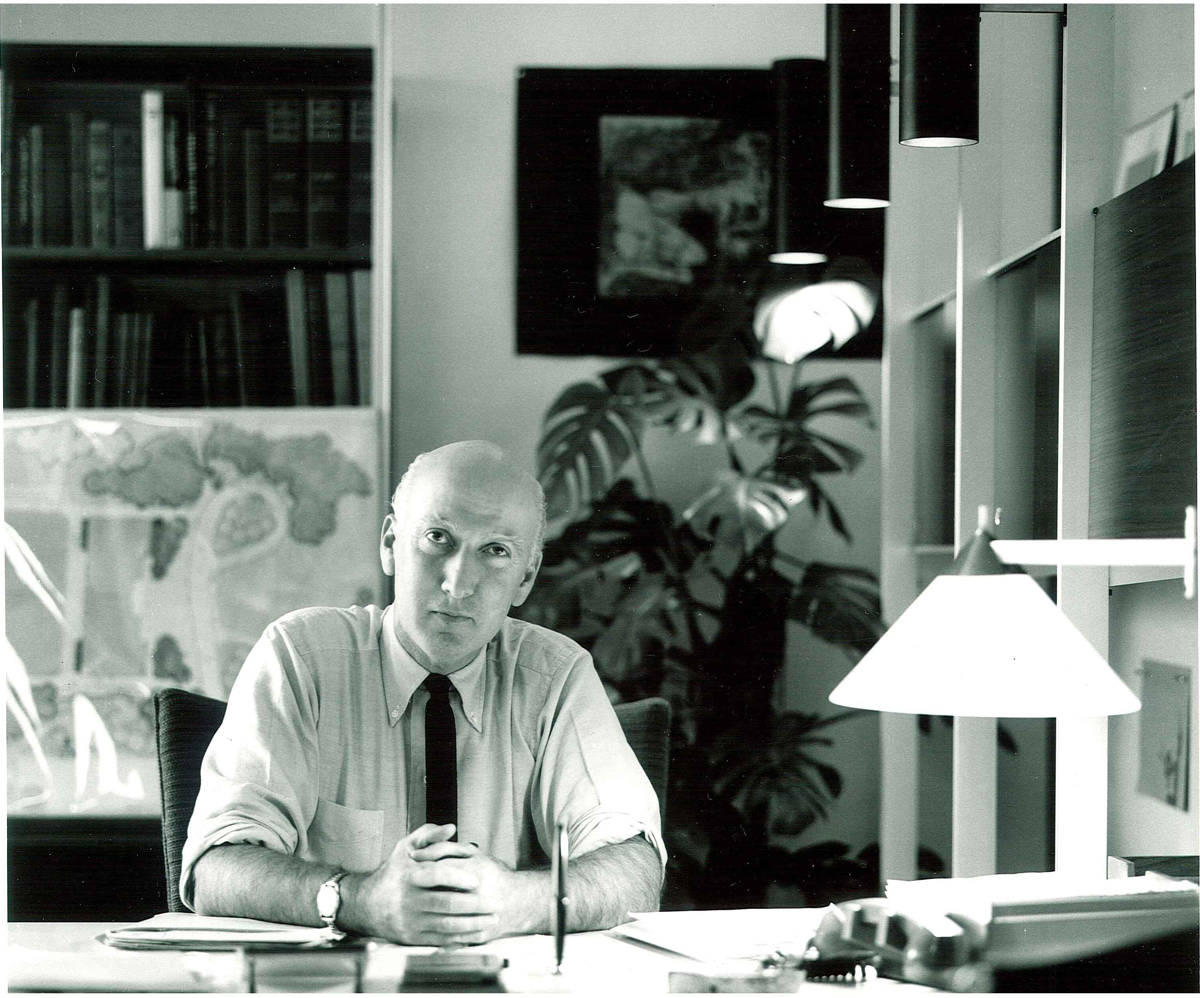
John Ormsbee Simonds, 1913–2005.
By the time Simonds engaged in riverfront projects, he had achieved considerable stature in the landscape architecture profession. His 1961 book, Landscape Architecture: The Shaping of Man’s Natural Environment, quickly became the premier text in landscape architecture schools. 3 The American Society of Landscape Architects elected him as its president in 1963, and he also served on appointed federal commissions during the 1960s. Simonds had thirty years of practice, nationally acclaimed designs, and several more publications by the end of the decade. A frequently invited speaker and senior partner of the firm Simonds and Simonds that practiced well beyond its western Pennsylvania home territory, John Ormsbee Simonds was an influential figure during the years that waterfront planning gained momentum in the United States. 4 Commercial priorities typically predominated in waterfront redevelopment, and he did not eschew their importance; but he also never lost sight of the environmental qualities that made waterfronts special places within an urban setting. Working at a time when waterfront redevelopment had to overcome many obstacles in order to become reality, Simonds' planning efforts and those of others, who shared his philosophy or in some cases advocated an even more robust ecological approach, helped to lay the foundation for the movement’s success in the closing decades of the twentieth century.
Waterfront Planning Precedents
When Simonds first encountered riverfront revitalization, probably during Pittsburgh’s celebrated planning of its Point State Park in the 1950s, most urban waterfronts across America presented a shabby, tired appearance. Cities treated the central waterfronts as part of their commercial and industrial infrastructure. They traditionally contained an intense concentration of port facilities. Wharves, warehouses, cranes, ship provisioners, repair yards, and railroad tracks crowded the harbor’s edge adjacent to severely polluted waters. By the early twentieth century, these congested ports also housed grain elevators, oil storage tanks, food processors, coal-fired power plants, sewage treatment sites, and small manufacturers struggling to survive. Waterfronts were cacophonous, rough-and-tumble nineteenth-century artifacts contrasting unfavorably with downtowns proudly turning away from aging warehouses and wharves to modern clusters of skyscrapers, department stores, and grand railroad terminals.
Frederick Law Olmsted saw the opportunity for splendid parks on waterfronts. In a late 1860’s report for Riverside, the new suburban town located a few miles west of Chicago, Olmsted and his partner Calvert Vaux underscored the principle of preserving a site’s outstanding natural features for the benefit of the entire community. They proposed damming the Des Plaines River to augment its recreational and scenic utility and reserving the riverbank for park land. 5 In the following decades, Olmsted mapped out for Boston a park for the Muddy River valley and a waterfront promenade in his Charlesbank scheme. 6 A few years later, he worked with Daniel Burnham on the astonishingly successful Chicago World’s Fair, which demonstrated good landscape design on an urban waterfront. Early in 1893 journalist and planner Sylvester Baxter and Charles Eliot, who had studied and worked with Olmsted, produced a report for the Metropolitan Park Commission in Boston, which presaged some of the principles by which Simonds designed his park plans. Thinking on a metropolitan scale, they especially valued the region’s rivers and streams and their accompanying low-lying lands for park preservation, in effect forming the riparian corridors Simonds later called urban blueways. These preserved waterways, along with beaches, islands, and native forest, would, they hoped, bring nature into the city. 7
After the turn of the century, plans of the City Beautiful movement frequently projected formal waterfront parks. The 1902 McMillan Plan for Washington by Daniel Burnham, Charles F. McKim, and Frederick Law Olmsted Jr., proposed a water park for the Anacostia River Flat, which was not executed. The construction of Warren Manning’s three-mile long River Front Park along the Susquehanna in Harrisburg showed the possibilities of reclaiming waterfronts. Park development along the banks of the Schuylkill River in Philadelphia, John C. Olmsted’s boulevard plan for the shore of Seattle’s Lake Washington, and several other proposals revealed the interest in improving waterfronts. 8 None, perhaps, left more of an impression than Burnham’s seven-mile long Chicago lakefront scheme in his famous 1909 Plan of Chicago and the implementation of extensive parts of it during subsequent decades. 9 Even as the City Beautiful gave way to the City Practical, planners continued to propose waterfront parks. For example, Werner Hegemann envisioned coexisting harbor facilities and parks on the Sacremento and Oakland waterfronts. For Milwaukee, he pictured pedestrian malls on both sides of its river, while Frederick Law Olmsted Jr., urged Simonds' Pittsburgh to construct a promenade overlooking the Monongahela River wharf. 10
Notwithstanding such prominent examples of planned and constructed parks, few cities wrested their waterfronts back from the clutches of commerce and industry before the mid-twentieth century. Grand plans usually gathered dust on the shelves of public officials and nonprofit organizations interested in city betterment. 11 Business interests, private property rights, and extant land uses trumped values of public access and aesthetic improvements, despite the decline of central port functions when larger cargo handling technologies and ships required the erection of port facilities far from older central locations. The Great Depression hastened the deterioration of outdated docks and warehouses.
However, with municipal resources at low ebb, the New Deal financed some waterfront improvements. The despair of longshoremen and wharf businesses drew the attention of government officials anxious to encourage development and stimulate employment. The Works Progress Administration (WPA) funded small waterfront parks and other projects along waterfronts. Noteworthy for its longer-term implications was the WPA’s support for construction of San Antonio’s Paseo del Rio, the realization of architect Robert Hugman’s riverwalk vision without the commercial aspects that would come a few decades later. New York parks impresario Robert Moses took the opportunity to advance some of his projects with New Deal funding. In the late 1930s, he completed Riverside Park with recreational facilities, trails, vistas, and a boat basin; the parkway along the Hudson River; and the Henry Hudson Bridge. On the other side of Manhattan, he filled in new land to create East River Park and in 1941 began the development of Battery Park at the southern tip of the island. 12
Federally assisted projects and notable examples such as San Antonio’s Paseo del Rio did not, however, herald the beginning of waterfront revitalization across the nation. The challenges to transforming America’s central waterfronts into open space resumed after the war. Highway engineers identified decaying waterfronts as logical locations for new expressways. Postwar expressway construction cut off many waterfronts from adjacent neighborhoods and downtowns. Now, Moses' New York riverfront improvements of the 1930s were criticized for privileging automobiles over pedestrian access. In his influential 1963 book titled Cities, landscape architect Lawrence Halprin disparaged the “five tiers of transportation facilities” that separated the Hudson River from adjacent neighborhoods. He added that “It is true there are trees, but they are only decoration. The whole city has been divorced from the great Hudson River waterway…, even though the actual design is pleasant.” In addition to the barrier that expressways created, shipping firms, dockworkers unions, and port authorities fought to retain traditional waterfront functions in the face of daunting competitive pressures from ports outfitted for containerization and still larger ships. Thus, most central waterfronts languished into the 1960s. 13
Gathering Momentum
In the late 1950s and early 1960s when Simonds undertook more and more planning projects, several factors began to converge to increase interest in reclaiming and regenerating city waterfronts. Foremost was federal urban renewal policy that civic leaders and planners employed to redevelop declining downtowns. Urban renewal offered federal funding for revitalizing derelict waterfronts, thereby removing blighted districts believed to be weighing heavily on adjacent downtowns and fashioning new venues to attract people back to central business areas. For example, discussions about refurbishing Baltimore’s deteriorated inner harbor of dilapidated sheds and neglected wharves accompanied the planning and development of its downtown Charles Center renewal project, which was completed in 1963. 14 An Inner Harbor plan followed a year later. In Pittsburgh, where Simonds practiced, the city and state’s commitment to clean up the historic Point at the confluence of the three rivers and develop a prestigious park unlocked private investment for construction of the proposed adjacent Gateway Center office complex. Most important for river cities was the revival of San Antonio’s Paseo del Rio. Having been neglected since its construction, Hugman’s prescient project had deteriorated into a crime-ridden walkway. Private leadership embarked on an ambitious, highly successful initiative to develop a lively riverwalk of shops, restaurants, hotels, and entertainment. The River Walk became an inspiration and model for river cities across the nation. 15
The desire to preserve historic buildings, often in response to the brutalism of urban renewal, also stirred interest in waterfronts. The 1964 Ghirardelli Square project that turned an old chocolate factory into a successful retail and restaurant complex on San Francisco’s waterfront highlighted adaptive reuse of old buildings and the potential of festival markets. In Savannah, the opening of a bar, restaurant, and shops in an old cotton warehouse sparked a waterfront revival. The defeat a few years later of Robert Moses' proposed expressway along the Mississippi riverfront next to New Orleans' Vieux Carre reflected growing sentiment for the preservation of these historic zones for public access. By the early 1970s, historic preservation had become integral to plans for waterfront development in New York, Boston, San Francisco, and several other cities. 16
While urban renewal focused attention on waterfronts for economic redevelopment, some urbanists catching the spirit of the emerging environmental movement saw them as opportunities for restoring nature, augmenting open space, and providing recreation in cities. Rachel Carson’s writings, Ansel Adams' photographs, publicity about the pall of smog hanging over Los Angeles, and the appetite for outdoor leisure in increasingly prosperous postwar America stirred an environmental consciousness among Americans hitherto preoccupied with other concerns. The defeat in the mid-1950s of the proposed Echo Park Dam that would have inundated Dinosaur National Monument transformed sedate, reasoned conservationists into politically oriented, publicity conscious environmental activists outraged over environmental degradation, the relentless loss of natural habitat, and pollution’s deleterious impacts on public health. Reflecting this growing political momentum, President John F. Kennedy convened a White House Conference on Conservation in 1962, and Congress passed legislation such as the 1963 Clean Air Act and 1964 Wilderness Act. 17
Urban environmental needs were not overlooked. Indeed, federal legislation after 1960 set aside funds for acquiring open spaces for parks, including urban land. The report of the Outdoor Recreation Resources Review Commission, formed by Congress in 1958 and chaired by Laurence S. Rockefeller, sparked concern for providing open space in cities, despite its specific charge not to consider urban areas. 18 The 1961 Housing Act allowed for the acquisition of open spaces in urban areas. The Bureau of Outdoor Recreation administered land acquisition under the 1964 Land and Water Conservation Fund, while the following year, the Housing and Urban Development Act proposed a program for acquiring land in developed areas that specifically included waterfronts. Not one to overlook a gathering political force, President Lyndon Baines Johnson included concern for conservation and natural beauty in his Great Society vision and expounded it in a message to Congress in February 1965. A few months later, Johnson called a “White House Conference on Natural Beauty” to discover new ideas and increase support for already proposed ones. In his charge to the Conference, the President underscored the need to clean up polluted rivers and announced a demonstration project for the Potomac River, which he hoped would “inspire similar efforts by State and local governments on other urban rivers and waterfronts….” 19
Johnson’s “White House Conference on Natural Beauty” indicated that restoring waterfronts had become a component of the nation’s urban conservation and redevelopment conversation. The Conference was organized around fifteen topical panels comprised of design and redevelopment professionals, federal officials, and Congressmen. Simonds chaired the panel on “City Parks and Open Space,” in which waterfronts frequently entered the discussion, while the editor of Landscape Architecture Grady Clay headed a panel titled “Water and Waterfronts.” Yale planning professor Christopher Tunnard, urban planner Carl Feiss, and New Jersey’s US Senator Harrison Williams all noted the decrepit state of urban waterfronts and the pressing need to reclaim them. Senator Williams stated, “Restoration of our waterfront areas should also be high on our agenda, and more attention could be given to utilizing our city lake and river systems for boating, fishing, and leisurely pastimes.” Carl Feiss acknowledged that waterfront improvements were underway in cities like St. Louis, Detroit, and Pittsburgh; but he decried the ugliness that still existed around water in most cities, proclaiming that only Chicago, Minneapolis, and San Antonio had made “superlative use of their urban water resources for beauty and recreation.” 20 Together the many observations about waterfronts in these panels revealed the significance that participants placed on their revitalization for conservation and urban renewal. The seeds for waterfront revitalization in America’s cities had been planted. By the late 1960s, local officials, planners, and private interests busily envisioned, debated, and negotiated waterfront projects some of which would materialize as notable achievements in subsequent years.
John Ormsbee Simonds and Environmental Planning
Simonds' planning for riverfront improvements and extensive water-oriented urban parks grew out of his practical experience and philosophy of landscape architecture and planning. When he undertook the Chicago assignment in 1962, he had already been in private practice for more than twenty years in Pittsburgh. He opened the practice in 1939 with his brother Philip, not long after earning his Masters of Landscape Architecture (MLA) from Harvard’s Graduate School of Design (GSD). At Harvard, he and fellow students like Garrett Eckbo, Jim Rose, and Dan Kiley absorbed the tenets of modernism preached by such luminaries as Joseph Hudnut, Walter Gropius, and Christopher Tunnard, who taught landscape architecture there. He attended Harvard during the early years of Dean Hudnut’s radical reorientation of the design schools, which embraced modernism and strived to overcome the long-standing separation among the architecture, landscape architecture, and planning departments. As a result, Simonds was exposed to the importance of collaboration among the three disciplines, including an affinity between his chosen profession and planning. Described appropriately as a modernist by colleagues, Simonds also brought a deep appreciation of the natural environment to his work throughout his career. 21
Born in 1913 to a circuit-riding minister in North Dakota, Simonds experienced the outdoors there and in Michigan where the family moved. He left Michigan State University in the midst of his undergraduate studies in 1933 to travel the world on a tramp steamer sailing from California. He spent time in Borneo where he experienced the wonders of the tropical jungle and its peoples. After graduating from Michigan State in 1935, Simonds spent a year with the Civilian Conservation Corps in northern Michigan restoring logged over lands and supervising the construction of a state park. He then went eastward to pursue professional studies at the GSD. Upon graduation from Harvard, Simonds joined fellow graduate and future partner Lester A. Collins in an ambitious journey to study Asian landscapes from Japan and China to Tibet, India, and southeast Asian countries. Later in life he would acknowledge the importance of this trip for his landscape perspective; colleagues commented on his Zen-like appreciation of the relationship of man and nature. Educated in the modernist hothouse of Harvard, deeply imbued with the wonders of nature, and forever influenced by his Asian travels, Simonds had the foundation in place, upon which he built a coherent approach to landscape architecture. 22
Early in Simonds' professional life, an additional experience significantly influenced the direction of his career. The new firm of Simonds and Simonds toiled initially on landscape planning for residences around Pittsburgh. However, as the brothers were establishing their reputation, the Smoky City was aggressively pursuing the most ambitious redevelopment strategy of any American city at the time, Pittsburgh’s Renaissance. As soon as World War II ended, the powerful corporate-dominated Allegheny Conference on Community Development cooperated with Democratic public officials to clear the city’s skies through smoke control regulation, clean up the rivers by building a sewage treatment plant, and redevelop deteriorating downtown spaces, especially the point of land at the head of the Ohio River. Simonds partnered with architectural firms on several of Renaissance’s signature projects in the 1950s and early 1960s. He witnessed the possibilities of improving urban design and open spaces through planning when public and private leaders forged a partnership and inspired the public’s enthusiasm for large-scale change. Further, he forged a friendship with the city’s elder statesman of planning, Frederick Bigger, whom he later credited with teaching him a great deal about planning communities. 23 Simonds frequently held out Pittsburgh’s example to other cities' leaders, exhorting them to think ambitiously about revitalizing their downtowns and riverfronts. Most importantly, the Renaissance experience expanded his firm’s repertoire to include large-scale, land-use planning. 24
Although Simonds considered himself a problem solver who collaborated with architects, engineers, and economists, he was at his core an environmental planner. Later in life, Simonds observed that he and fellow students at the Harvard GSD searched earnestly but in vain to discover the “essence” of the new modernism sweeping aside the old Beaux Arts canon of landscape design. The pilgrimage to Asia with Collins, several years of practice, and seemingly unrelated pursuits such as hunting led Simonds to realize that the beauty he and others sought from their plans and designs came from “the perception of harmonious relationships [which] produces an experience of pleasure….” Beauty could not be imposed or contrived. He wrote, “All planning of and within the landscape should seek the optimum relationship between people and their living environment....” 25 Thus, one plans an experience. Spaces and forms become the tools to achieve the desired experience.
Central to designing the relationships that made for the desired pleasurable experience was, in Simonds' perspective, planning human land uses in harmony with nature. He defined landscape architecture in terms of this fundamental principle. In a letter to the editor of Landscape Architecture written while in retirement, Simonds described his profession as “the art and science of preserving or creating compatible relationships between people and their activities and the natural world about them.” 26 Land uses, our “way of living,” must be “attuned to the natural world.” 27 In order to fulfill this aspiration, he advocated “comprehensive planning,” by which he meant including both human and environmental imperatives. He termed this “planning it all together.” 28 Others were thinking along similar lines. In 1968, William H. Whyte noted in his popular book, The Last Landscape, that one school of thought “so far confined to a handful of people, believes that open-space planning should take its cue from the patterns of nature itself....” 29 Landscape architect Ian McHarg and planner David Wallace employed an in-depth ecological analysis for their land-use plan of countryside vulnerable to the suburbanization rapidly spreading northwest of Baltimore. McHarg expounded fully on his ecological approach in his influential 1969 book, Design with Nature. Simonds also prepared a careful analysis of a site’s natural features, though in less depth than McHarg. He adhered to what he promoted as his P-C-D approach, whereby in an Olmstedian vein, the best of these features are “preserved in tact [sic].” Then, a “protective conservation band of limited use” is planned around the preserved features. Only then does the planner designate areas where full development could take place [underscores added by author]. 30
Given the importance of natural phenomena in his philosophy, Simonds stayed true to the heritage of a longline of landscape architects from Olmsted to McHarg by turning the conventional position of open space in American cities upside down. Rather than being the afterthought of development or “superficial embellishment” as Anne Whiston Spirn wrote, open spaces and particularly a network of interconnected open spaces, including waterfronts, should become the defining aspect of a city. 31 In 1966, Simonds lamented that highways structured American cities, a stark contrast to the vision of park networks as the defining framework. 32 In this respect, he was fond of quoting Kublai Khan’s projection for his planning of Peking. Simonds introduced his comments at the White House Conference, for example, by reminding participants that Khan said, “It is not enough to build parks in our city. Rather, we shall create our whole city as a park.” 33 Years later Simonds wrote that “The character and livability of a city are largely determined by the nature and arrangement of its open spaces.” 34 In his view, the various natural and man-made open spaces such as parks and plazas should be interconnected by greenways of pedestrian paths, bicycle trails, and parkways as well as blueways of protected stream corridors, riverfronts, and shorelines. The resulting network of open spaces of different dimensions, features, and functions would become part of an urbanite’s daily experience. In planning new towns, abundant and appropriate open spaces could be built into the original vision and subsequent development. Existing cities had to be opened up by reclaiming and restoring natural features. It is as if the cities would “invite nature back into its confines” through careful, sensitive planning. 35
Water occupied a commanding position in Simonds' landscape and planning philosophy. “Free water,” he believed “is the shining splendor of the natural landscape.... To some degree we humans still seem to share with our earliest predecessors the urgent and instinctive sense that drew them to the water’s edge.” 36 The integrity of all water features from impressive water bodies such as lakes, harbors, and rivers to prosaic drainageways and wetlands should be undisturbed in order to protect their scenic values and ecological functions. He felt that governments should acquire water features and their land edges for inclusion in the public domain. In built-up landscapes, streams that were buried in culverts or artificially channeled should be daylighted and ecologically restored. 37 Intensely developed water edges such as waterfronts required expensive actions of acquisition, demolition, clean up, and restoration, which would often be sharply opposed.
The preservation and conservation of water features and their edges, Simonds pointed out, presented great possibilities for creating open spaces that could provide pleasurable natural and human land-use relationships. On a metropolitan scale, preserved watershed drainageways formed linear natural corridors by which routes of movement could be aligned “in harmony with the line of flow.” 38 They established interconnected networks of movement and fulfilled their ecological roles of absorbing and filtering water runoff while buffering development with extensive park lands. Simonds may have had in mind the precedent setting Bronx River Parkway or the exhortations on behalf of parkways by John Nolen and Henry Hubbard in 1937. 39 He called these linear parks of extended stream edges, river frontage, and shorelines “blueways.” With walkways and bicycle paths near the water edges and carefully designed parkways removed closer to the boundary of the conservation and development zones, blueways created natural networks for connecting open spaces while adding recreational, scenic, and ecological value. 40 Simonds warned that the transition caused by the meeting of water and land required careful planning. Landscape architects had to express and soften the transition without losing sight of the larger ecological and human use aims (Figure 2 ). Water’s primacy as a natural feature also demanded the planning of views. He advocated view management by planning views along the blueway corridors, which both varied in perspective and were sequenced so as to attract, surprise, and delight users. 41
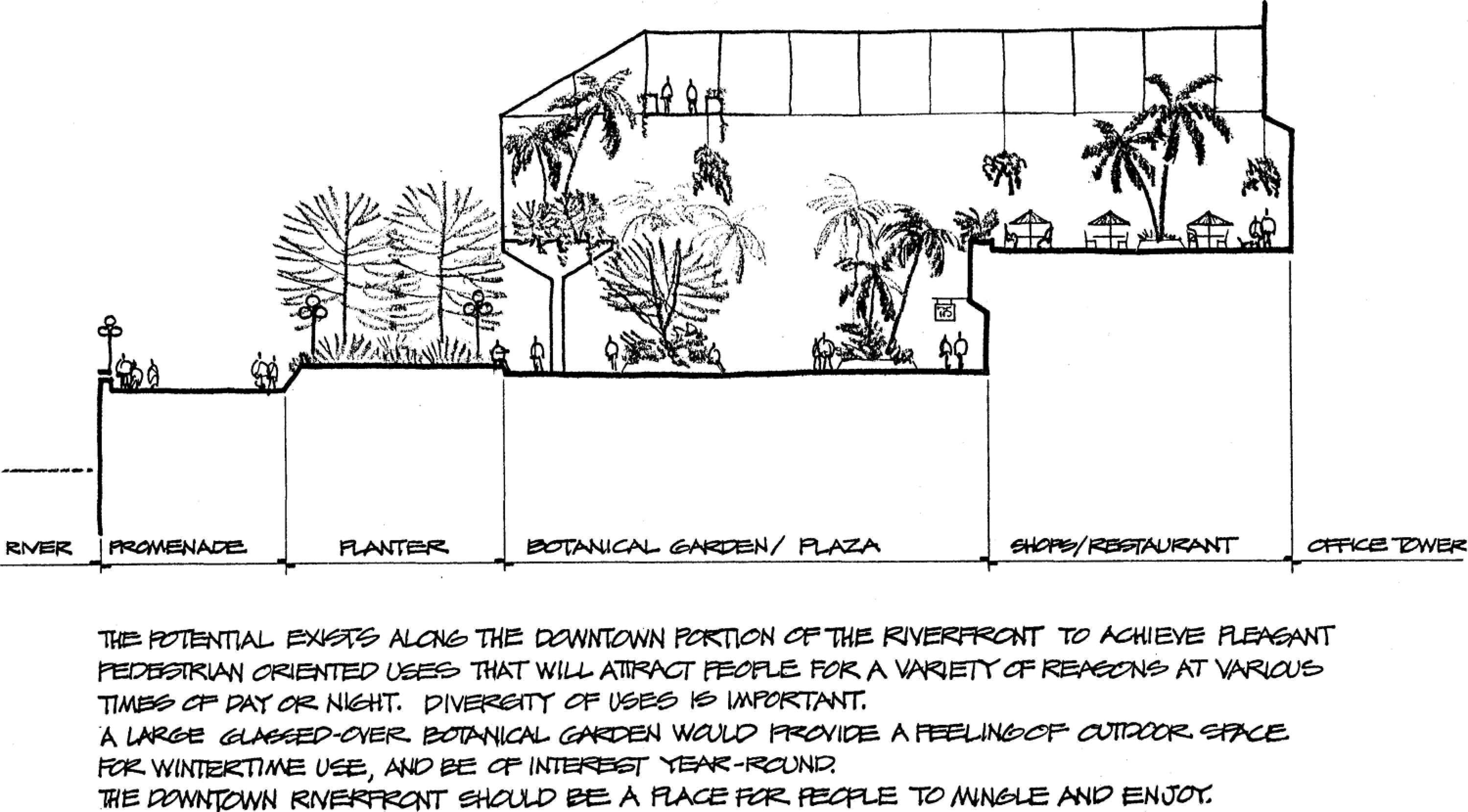
Saginaw, Michigan, 1979. A plan for the downtown riverfront to provide both diverse pedestrian activities, where people can mingle and a glassed encased botanical garden with a feeling of outdoor space in winter.
An important component of a blueways system of open spaces was the central waterfront. In Simonds' scheme, a reclaimed waterfront should, if possible, be integrated with the blueways system of open spaces and fully accessible to the public. However, he recognized that the central waterfront had special characteristics and roles within the city different from those of open spaces elsewhere in the metropolitan region. A properly planned, revitalized waterfront would have an uplifting impact on the adjacent downtown (Figure 3 ). The environmental remediation of a polluted and busy harbor offered a water attraction to downtown workers and residents and to the rest of the metropolitan population, which often had little access to substantial water bodies. The historic quality of older waterfronts also required special consideration. These roles suggested simultaneous entertainment, recreational, and scenic functions for the waterfront. 42

Sketch for a proposed master plan for Wacker Drive and the Chicago riverfront, 1962.
The various roles and characteristics of central waterfronts complicated, but did not eliminate, Simonds' P-C-D approach. The water feature, the harbor, had to be restored and preserved to the greatest extent politically and functionally possible. The water edge and a more extensive conservation zone would accommodate light land uses such as public promenades. 43 However, the adaptive reuse of historic buildings, the demand for entertainment, the desirability of water views, and the centrality of the waterfront all meant that development would be judiciously allowed to penetrate the conservation zone. Extant hard edges and traditional waterfront activities, along with the high expectations for waterfront revitalization, challenged the natural values at the core of the blueways philosophy, but this philosophical approach remained the foundation for Simonds' work from Chicago’s riverfront to a consultative role in Fort Lauderdale twenty years later.
Simonds' Early Riverfront Recommendations
Beginning with the consultation on Wacker Drive and the Chicago riverfront in 1962, Simonds worked during the following twenty years with half a dozen cities in their efforts to improve their riverfronts. The emphasis on rivers and the associated reparian lands was a piece of Simonds' larger landscape perspective. At the same time, the firm was engaged in planning park systems, outdoor downtown pedestrian malls as part of urban renewal projects, and environmental and community friendly high-speed highway corridors. In many of these projects, Simonds underscored the potential of the riverfronts for urban improvement. With the growing number and range of consultations, Simonds and his brother as partners met weekly with their associates in charge of specific projects, monthly as partners for “status review,” and periodically in “bull-sessions” with the staff at the firm’s “rooftop garden retreat” for reports and speakers. 44 Simonds had his hand in all projects, often making the key decisions and presentations.
Between the mid-1960s and early 1970s, Simonds urged several cities to consider the potential contribution of their riverfronts to projects on which the firm was working. The White House Conference on Beauty for America, in which Simonds had an important role, inspired Chattanooga to engage Simonds and Simonds in 1966 to prepare a beautification study for the greater urban area. 45 During the three years of the study, Simonds and his associate R. Jackson Seay Jr., recommended the conservation of, as well as recreation along, Chattanooga’s riverfront. They proposed a Riverfront Development Authority to orchestrate this aspect of the larger beautification plan. Simonds told a local reporter that “When Chattanooga walks down off its mountainside and shakes hands with its river, this will be great.” 46
At the same time, the firm, renamed Environmental Planning and Design (EPD) in 1970, was advising the Tennessee River city, the firm consulted with the two small West Virginia Ohio River cities of Parkersburg and Huntington on creating pedestrian malls as part of downtown renewal projects. Despite the existence of a flood wall, Seay recommended that Huntington establish a port authority to provide public access to the riverfront with a park and marina. In Huntington and elsewhere, suggestions for riverfront improvements at meetings with business leaders typically elicited concerns that commercial river interests might be harmed. 47 The transformation of urban waterfronts from traditional commercial and industrial activities to environmental and recreational uses was only gaining momentum in the 1960s. Many cities from large ones such as San Francisco to smaller ones like Huntington had not yet grasped the new developmental opportunities that waterfronts offered. Simonds' recommendations of recreational uses often failed to persuade clients, especially when the riverfronts were not central to the project’s objectives.
A project to plan a highway corridor in central Milwaukee ran into such an obstacle when Simonds proposed a lakefront park. EPD contracted with the Milwaukee County Expressway and Transportation Commission in 1969 to develop plans for the land around the elevated interstate highway running from Marquette University over the Milwaukee River to Lake Michigan. Despite two previous studies of the central Milwaukee River area and a reactivated river committee, Simonds lamented that the riverfront had been neglected. He proposed pedestrian promenades and “specialized retail” services along the river. Together, he concluded, “these riverfront walks would complete a total major downtown pedestrian system... and provide an exciting focal point for Milwaukee’s central area.” He suggested siting a small shopping complex at the highway overpass as a “southern terminus” of the downtown riverfront pedestrian route. 48 In an interview with the Engineering News-Record, Simonds summarized the purpose of his outlook for the Milwaukee riverfront. “It provides the impetus for cleaning a scummy river and building a commercial, apartment and restaurant area beside it, tied in with industry and the rest of the community.” 49
Characteristically, Simonds set the limited planning scope of a project within a larger perspective. In Milwaukee, he did not confine his vision to riverfront and highway corridor recommendations. He proposed a walkway eastward in the highway corridor that would connect downtown with the lakefront. Simonds advocated developing the lakefront at this juncture, an area outside of his project’s boundaries, as a park with lagoons and a venue for recreation and commercial entertainment. “Such development,” his report concluded, “would provide economic return for the Harbor Commission and at the same time generate downtown activity and enhance the city environment.” 50 The Harbor Commission, however, was not ready to cede its traditional jurisdiction and mission for either the lakefront or river. Labeling the suggestion for a lakefront park a joke, the Commission resolutely snubbed proposals for recreational uses. Echoing concerns of downtown businesses for adequate parking space, the Commission indicated it had a prospective tenant, who wished to store automobiles on a forty acre parcel of these lands. The Harbor Commission’s determination to use its lands only for “harbor-oriented facilities or operations” reflected similar attitudes of many port authorities across the nation in the face of the movement for redeveloping waterfronts. 51
Other EPD consultations presented more direct, though still limited, possibilities to improve riverfronts. Between 1968 and 1972, Simonds advised Louisville’s Riverfront Commission on the design for the roof of a massive parking garage and connected belvedere that extended for two blocks over the new expressway along the Ohio River. He had first landscaped the roof of a parking garage in 1953 with his award-winning design for Mellon Square in Pittsburgh and would employ the strategy in other plans. The proposed design turned the belvedere into a small riverfront park, but a dispute with a local landscape architect terminated EPD’s participation in the project. 52
By then EPD had begun work for the South Bend (Indiana) Redevelopment Commission on the design of a pedestrian mall for the city’s Central Downtown Redevelopment Area. EPD suggested that the frontage along the west bank of the St. Joseph River “should belong to the public” with a site there reserved for a focal point at the end of the mall. 53 Although a cultural center was initially proposed, the city settled on a plaza with a stage for events to attract people downtown. South Bend hired another consultant for an extended greenbelt study of the river lands, but in 1974, EPD was designing enhancements for River Bend Plaza. At its completion, EPD requested slides of the plaza in order to promote the firm’s work at a time when entertainment venues along waterfronts were rapidly gaining popularity. 54
Other contracts specified the designing of urban parks, for which Simonds' plans capitalized on the possibilities that rivers presented. In the early 1970s, EPD won a contract to plan a park along the Ohio and Erie Canal in central Akron as part of a larger urban renewal project. Simonds treated the canal as a river knifing through the Rubber City. In addition to standard park amenities like playgrounds and tennis courts, EPD conceived of walkways along the canal’s banksides, pedestrian bridges, an observation tower, benches, water sculpture, and boat docks. 55
Long before undertaking the Akron study, Simonds had the chance to think about transforming some portions of his hometown’s riverfronts. In 1963, Simonds unveiled a plan for Twelve Mile Island, an island in the Allegheny River upstream from downtown Pittsburgh. Despite its distance from downtown, the island was squarely within the metropolitan area. 56 A sand and gravel company owned it and leased land for small seasonal cottages. A coal mine loomed nearby on the mainland, and several suburban industrial towns occupied sites up and downstream from the island. Recognizing the improving water quality of the region’s rivers and the growth of water-based recreation both locally and nationally, Simonds viewed Twelve Mile Island as an opportunity for Allegheny County to develop public access to the river. He proposed some reforestation and the traditional park facilities of picnic shelters, trails, and playing fields. But, he also added docks for small boats, designated fishing and wading spots, and recommended a mooring location for larger sightseeing craft. On the mainland, he envisioned a ferry site and boat launch. Moreover, Simonds urged the county to buy property on the mainland in order to create an extensive river park. 57 While the Twelve Mile Island plan never materialized, fifteen years later he entered into a contract for a portion of another island a few miles below downtown Pittsburgh, for which he produced a similar design. 58
Central Riverfront Plans
Simonds' recommendations for Chattanooga, Milwaukee, South Bend, and Huntington to reconsider their old riverfronts, even though the contracted projects did not include them, derived from his philosophy of environmental planning, awareness of the growing waterfront movement, and concurrent commissions that specifically involved riverfronts. Between 1962 and 1980, he worked on central riverfront plans for Chicago, Pittsburgh, Toledo, and Saginaw, each of which involved the prospect of intense development. 59 These plans demonstrate Simonds' understanding of the important roles central waterfronts could play in a city. They also reveal his penchant for viewing projects both in their entirety and for their fit into a larger spatial framework than the commissions defined. He advocated master plans that envisioned a coherent, unified whole for a site. Successful plans, in the end beauty itself he contended, depended on getting correct the relationships among nature, movement, open spaces, and land use functions. Simultaneously, he often wanted clients to consider the implications of their projects for adjacent districts, for all the parks of an urban area, and for the region itself. In this manner, he used a central riverfront project to urge civic leaders to think about developing or burnishing a metropolitan-wide blueways system.
In the May 1962 proposal to the Chicago Central Area Committee, Simonds made a case for preparing a master plan to improve Wacker Drive and the Chicago riverfront. He acknowledged the existing development in the river corridor, which included the prominent Wrigley Building and Tribune Square, as well as pending projects such as Marina City and the US Gypsum Tower, which heralded a bright future for the area. The problem, he intoned, was piecemeal development resulted in inadequate parking, open spaces unrelated to each other, and a riverfront “lined with solid blocks of structures which have no view of, or orientation to, the river.” A master plan would coordinate the various pieces into a coherent landscape and “create for the area a new public image of smooth function, bustle, beauty and distinction.” A team of professionals, the approach he favored, would prepare the plan. The team would enlist the aid of economic experts and solicit input from public agencies and private interests. 60
Six months later, Simonds made a presentation to the Board of the Chicago Central Area Committee, in which he laid out the rationale for a full-scale study of the two mile stretch of the highway and riverfront. It was vintage Simonds' philosophy of beauty. You are no doubt expecting me as a Landscape Architect to tell you how Wacker Drive and the Riverfront can be made more beautiful... But, first it is important that we understand what we mean by beautiful. Beauty isn’t something you can set around in pots, or paint a wall, or hang from lamp posts. Beauty is rather an end result – a quality which you sense when all the parts of a thing or place are working well together.
61
In this holistic approach, Simonds viewed revitalized central riverfronts as integral parts of a city’s larger open space system. He sought interconnections with the various kinds of open spaces found in metropolitan regions and advocated by him. Although central riverfronts had distinctive characteristics unlike those of other metropolitan parks, they should nonetheless be connected to “extensional accessways and conservation lands” so as to augment and complement an open space network. 64 He had in mind not only traditional parks but also the blueways formed by preserving the various drainageways and wetlands. Simonds told his Toledo and Saginaw clients that a network of parks and pathways, including the linear opportunities of riverfronts, would give their cities a new spatial orientation as a counterpoint to the geography that highways presently shaped. The Phase One Riverfront Study for Saginaw, for example, envisioned the riverfront “as a blue and green segment of a larger Saginaw open space framework around which, and within which, your evolving city will take form.” 65 Even on the limited scale of the Chicago study, he called for “interconnecting walkways and places.” He concluded that “The Wacker Drive Environs should be conceived as a complex of spaces, open and closed. .. all forms together organized into a well-coordinated place.” 66 Simonds' ambitious projection of reshaping cities via an extensive, interconnected park network had few precedents in America’s automobile-driven culture and little success in influencing urban development.
Simonds extended his holistic vision of riverfront planning to mitigating the physical and social disjunction between communities on each side of the river. He applauded Saginaw and Toledo for having the foresight to acquire property along both sides of their rivers. In contrast, he lamented the fragmented ownership patterns and land uses of railroads, highways, and industry, which prevented Pittsburgh from undertaking more ambitious riverfront projects. 67 He believed that with control of sufficient land and proper planning, riverfront redevelopment could unite communities, which rivers had separated. Activities on both sides must be planned to relate to each other. 68 The Toledo plan shows pedestrian pathways, parks, overlooks, and open spaces facing each other across the Maumee River. However, Simonds seems to have planned for only these visual relationships across the Maumee. When he returned in 1983 to update the Toledo plan and design International Park, he emphasized the visual relationship to the central riverfront across the Maumee from this proposed tourist attraction. Simonds also believed bridges were exceptional places from which to view water and, perhaps, he meant them to be a means to relate the riverfronts on each bank of the Maumee. The extant vehicular bridges show pedestrian egress to the riverfront parks; but there is little evidence that the plan encouraged pedestrian or bicycle use of the bridges. How visual relationships would overcome decades of historical separation without direct interconnection remains unclear. Fifteen years later in his book Garden Cities 21, he suggested methods to add pedestrian bike and walk ways to bridges. 69
Simonds encountered the challenge of a riverfront with a long history of separation from the opposite shore when he undertook planning for the Allegheny River’s north shore in Pittsburgh. Although several bridges spanned the river, the north shore never functioned as part of downtown and had deteriorated under the burden of industry, railroads, and vice activities. The prospect of a new multipurpose sports stadium arising on the north shore spurred the Department of Planning to hire EPD in 1968 to consider initially a far longer expanse of riverfront than the much smaller Roberto Clemente Park that the city finally settled on. For the segment across from downtown, Simonds discussed a multilevel, multiuse design with everything from public access for fishing and boating to private commercial and residential uses. He showed slides of San Antonio’s River Walk and European cities to invoke a vision of development that would complement downtown’s dense building fabric. 70 The city drastically narrowed the project’s scope, but Simonds retained in this smaller plan a marina, public dock, floating restaurant, water taxi stop, and motel, only a little of which survived in the final design. 71 The intensity of development envisioned initially for Pittsburgh suggests how Simonds viewed riverfronts associated with downtowns and foreshadowed more concrete plans for Toledo several years later.
Whether or not it could seamlessly connect with a metropolitan blueways system or unite communities across the river, a reclaimed central riverfront had critical functions to perform for revitalizing the adjacent downtown. Simonds began by highlighting the water feature. The river, he argued, was the primary attraction; planning had to keep the focus on it. With sufficient waterfront land in the public domain, Toledo and Saginaw had ideal opportunities for creating magnificent parks and associated development. “Promenade Park,” he told Toledo’s city council, “without any exception had to be the crowning jewel of your city and your park system.” 72 To luncheon guests in Saginaw, he asserted that “A good riverfront plan is far more than riverfront decoration. It reorients and revitalizes the entire community.” Even in Pittsburgh and Chicago, where the banksides were thin strips of heavily developed land, he advocated that plans “should take all opportunities to provide the people with water contact.” 73 Pittsburgh’s narrow, north shore strip of land adjacent to Three Rivers Stadium was situated across the Allegheny River from the Smoky City’s Renaissance transformation. Simonds designed an “undulated” waters edge path, as well as benches and overlooks, which provided views of the confluence of the three rivers, downtown’s new skyline, Point State Park, and the fountain at the tip. 74
If the water feature and shoreline were the front of a riverfront park, then the back side bordering downtown also had an important function. Businessmen and politicians hoped a reclaimed waterfront would stimulate the redevelopment of their sagging downtown reeling from the competition of suburban malls, office campuses, and entertainment complexes. Simonds intended that a riverfront park perform this function by opening the business district to the water’s attractions. 75 By the mid-twentieth century, the downtowns of most American cities had little connection with their waterfronts. Simonds wished to reconnect these former spatial partners. To Toledo’s city council, he averred that “we can’t have a park on the riverfront and the city above it, you have to have a city and park that meet and mix together on the riverfront.” 76 A dozen years earlier, he proposed in Chicago that the careful “arrangement of open spaces,” so that new plazas could penetrate “into existing blocks to open up interior spaces and orient them to the [Wacker] Drive and the river.” 77 Similarly, he told Toledo that its “riverfront park will open upward and into the city. A network of attractive pedestrian walkways, plazas, and malls will refresh and revitalize the downtown, enhance real estate values, and provide inviting ways and places leading down to the water’s edge.” 78 The park’s success depended on the efficacy of these connections to the business district and adjacent residential neighborhoods. He welcomed collaboration with economic analysts to plan the benefits for Toledo of reorienting downtown to the waterfront. 79
The challenge was to design a central riverfront that effectively interfaced with the downtown, while creating a place with a signature image or identity that appealed to the metropolitan population. To achieve these aims, a revitalized riverfront had to be “urban and urbane in character,” and therefore Simonds argued that the design called for an “urban treatment for the waters edge.” 80 To the Chicago Central Area Committee, he advised it strive for “the development of [a] world-famous riverfront and thus a civic feature of first magnitude.” 81 The existing development along the Chicago River limited design opportunities to an intense refurbishment of the narrow riverfront. He proposed that “By all means the river banks should be improved, walled, terraced, decked, planted and developed as a civic riverside with boat landings and possibly restaurants and shops... At the upper level a flying overlook promenade would be a dramatic, highly attractive feature.” 82 His vision had more in common with riverfronts of older European cities than with the broader, formerly industrialized banksides of American river cities. 83
Saginaw and Toledo’s riverfronts furnished spacious sites on which Simonds could demonstrate his “urban and urbane” vision. Simonds' Promenade Park was to be a business, civic, and cultural venue for Toledo integrated with downtown and the previously proposed sports arena and community conference center by a pedestrian mall, skywalks, and vehicular extensions into the park (Figure 4 ). The design terraced the site down to the river in a manner reminiscent of his earlier deliberations for Pittsburgh’s north shore. Terracing provided gardens, courts, and restaurants with views of the Maumee River and the extensive park on the opposite shore. Scattered amid the site, particularly closer to and along Summit Street that bordered downtown, were commercial uses such as an office tower, hotel, and shops, along with some existing businesses. Taking advantage of the multilevel design, Simonds inserted parking garages with landscaped roofs that linked smoothly with other planned open spaces. Nearer to the water, he projected a “boatel,” ice skating rink, art center and museum, restaurants, and amphitheater. He located housing toward the peripheral sides of the site. Walkways, a marina, overlooks, and a public wharf occupied the waters edge. The many gardens, courts, lawns, and plazas formed an interconnected network of open spaces, detailed with attractive paving, planters, benches and other furniture, fountains, and lighting. The urbane treatment left little of the natural character of the waters edge; but immediately beyond the two bridges that framed the central riverfront, Simonds' Promenade Park linked up with proposed blueways along the banksides and greenways penetrating new housing complexes and existing neighborhoods.
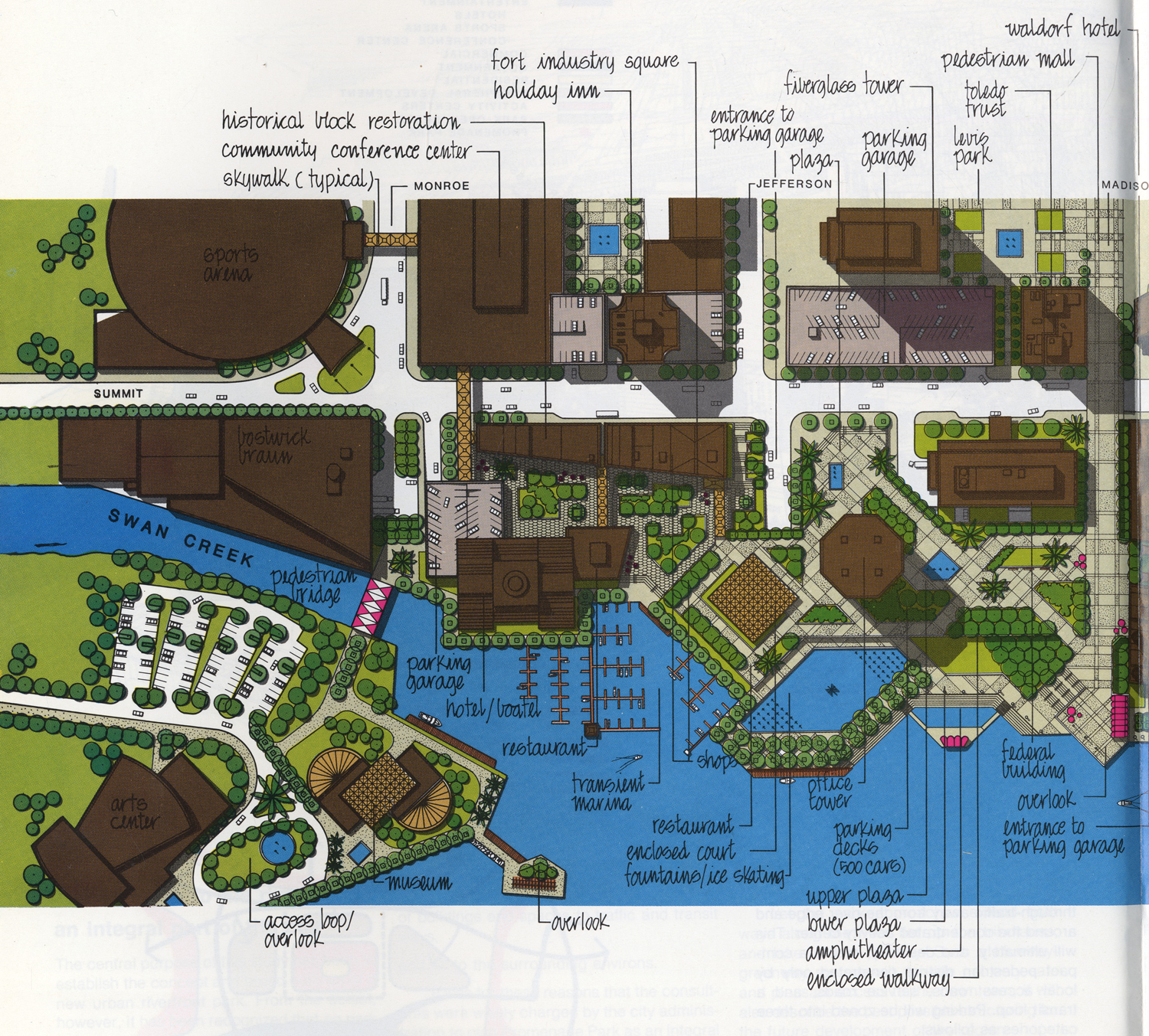
Plan for half of Promenade Park, the central riverfront of Toledo, Ohio, 1975.
He designed Promenade Park, his most complete riverfront plan, to be an extension of downtown, complementing already proposed entertainment venues with opportunities for year-round programming. He oriented its features to the river and placed them within a landscaped setting that invited relaxation, reflection, and casual strolling. At the same time, the intensely developed site connected with the region’s blueways system. 84
Conclusion
When Simonds became involved in urban riverfront planning in the 1960s, he was joining a movement in its formative phase. Like waterfronts in general, riverfronts had been important sites of America’s industrial growth, which had experienced severe functional decline and physical deterioration. Unlike their coastal siblings, riverfronts tended to be small and linear in available acreage, not controlled by a single port authority, and threatened regularly by floods. Urban rivers and riverfronts did not have the same romantic, historical mystique that seaports and maritime activity engendered. They were unloved and taken for granted except by river shipping interests that had for decades strenuously protected their prerogatives to the commercial use of the channels and banksides. When civic leaders considered redevelopment of their riverfronts, they were less inclined and able to undertake large-scale commercial projects than leaders in coastal cities were.
By the early 1960s, waterfronts attracted the attention of civic leaders, who wished to redevelop these centrally located, underperforming sites at the heart of their cities. In the post–World War II era, they could use public–private partnerships to foster political consensus and tap into federal transportation and urban renewal programs to fund redevelopment. Plans for commercial, residential, and most especially entertainment complexes such as festival markets on the waterfronts of coastal port cities set the tone for the movement. By the early 1970s, nearly 100 large and small cities were reportedly rethinking their waterfronts. 85 Civic responsibilities, citizen engagement, and limited funding often complicated, delayed, or stymied reuse, but notable successes in New York, Seattle, Boston, and Baltimore among others spurred civic leaders across the nation to craft their own waterfront solutions.
Although commercial reuses advocated by developers with strong corporate resources tended to dominate revitalization, environmentalist and stakeholder groups increasingly influenced waterfront planners to incorporate historical, ecological, scenic, and recreational values in their projects. 86 In 1990, writer Charles Little exclaimed that “We are rediscovering the urban river,” especially as greenways in the city. Little credited environmentalists and the 1972 Clean Water Act for having accelerated this trend in the 1980s. 87 Naturalist Michael Houck charged that many urban planners not only ignored the ecological aspects of projects but also believed poor communities had little interest in nature. In the early 1990s, he and others formed a grassroots-oriented organization, Coalition to Restore Urban Waters, with the support of some federal agencies and national environmental organizations to restore rivers, streams, and wetlands in cities and particularly in disadvantaged neighborhoods. 88
Simonds and a few others such as William H. Whyte and Ian McHarg perceived urban rivers and riverfronts in a similar light more than twenty years before Little and Houck were writing. They were transitional figures in the transformation of riverfronts, shedding light on them as sites of not only commercial redevelopment but also the restoration and enjoyment of nature. Bringing his sensibility of the importance of planning land uses in harmony with nature, what he called environmental planning, Simonds viewed the central riverfront as part, almost the keystone, of a metropolitan blueways system of interconnected drainageways and riverside corridors. Urban rivers and the lineaments of the tributary watershed, when restored, would conserve natural features, provide ample park lands accessible to the public, and establish corridors of movement. Like Little years later, Simonds argued that with proper environmental planning, urban blueways would invigorate and unite the people of a city rather than separate them as they had in the past. 89 Central riverfronts had the additional responsibility of complementing the revitalization of downtown. They had to relate to downtown, accommodate commercial development, and still feature the natural assets of the sites. As the pivotal part of the blueways system, they underscored the significance of water as an attraction and the necessity for environmental awareness and remedial action. Central riverfronts became a gateway to a conversation about establishing a regional watershed parks program. In thinking beyond simply commercial redevelopment when the commission made it possible, Simonds ran counter to prevailing waterfront orthodoxy of developers, the Army Corps of Engineers, civic leaders, and many municipal planners. Through his many professional activities, Simonds promoted the revitalization of riverfronts and foreshadowed the more holistic and ecological urban rivers movement advocated by Little, Houck, and others, which emerged toward the end of the century.
Footnotes
Notes
Acknowledgments
The author would like to thank John Nemmers and his staff of the George A. Smathers Libraries at the University of Florida; Jack R. Scholl, principal partner of EPD, LLC, Pittsburgh, PA; John F. Bauman; and two anonymous reviewers.
Declaration of Conflicting Interests
The author declared no potential conflicts of interest with respect to the research, authorship, and/or publication of this article.
Funding
The author received no financial support for the research, authorship, and/or publication of this article.