
Abstract
In the former Soviet Union, traditional urban districts with pre–World War II housing were considered obsolete and the aim was to demolish them, but in practice they were frequently ignored, because efforts were focused on new housing production in order to address acute housing shortages. Inertial forces stymied plan implementation for older districts during a rich period of plan making while new residential districts were built at a fast pace on virgin land. This research analyzes more than a dozen written planning documents from various periods during the twentieth century for Tartu, Estonia, where, had mid-twentieth century town plans been implemented, entire districts of nineteenth-century and early twentieth-century wooden houses and apartment buildings would have been demolished. Findings suggest that several factors acted in concert to set the conditions for both neglect and preservation of such districts during the second half of the twentieth century that resulted in continuous occupancy of the dwellings and preserved the built form (and the social structure) of the district. These factors include a focus on building new housing and new districts rather than renovating older districts; a lack of resources to renovate older districts; and a lack of resources to implement plans. This synthesis of town planning in Estonia demonstrates how planning ideas have evolved throughout the twentieth century parallel to—but temporally delayed compared to—Western Europe and North America.
Introduction
Most European centers, including the post-Socialist cities of the Former Soviet Union (FSU), possess a heterogeneous built environment that is the legacy of various political, economic, and social forces. In the FSU, traditional urban districts with pre–World War II housing were normally considered obsolete and the aim was to demolish them, but in practice they were often simply ignored because efforts were focused on new housing production in order to address acute housing shortages. 1 In Western European cities, however, comparable urban districts containing worker housing were also considered obsolete and often were, in fact, demolished because their proximity to the center made them ripe for redevelopment as sites for new housing and urban expansion.
Many former socialist cities possess a heterogeneous urban structure and neighborhood typology, even though socialist ideology supported homogeneity—in dwelling units, apartment buildings, and neighborhoods—and access to comparable services and infrastructure across districts. This phenomenon suggests less control than is normally assumed of socialist leadership, as it is commonly accepted that political systems with strong ideologies are impelled to leave an imprint on the built environment as a way of demonstrating societal control. For countries of the FSU, physical planning was a key mechanism for shaping the centrally planned economy and containing communist ideals. 2 Yet this imprint is strikingly absent from pre–World War II urban districts that appear untouched during the Soviet years.
This research offers an in-depth inquiry into the influence of town planning on continuity and change—due to inertia and other forces—in a small post-Socialist Baltic city and the existence of juxtaposed neighborhoods (i.e., modernist districts and early twentieth-century neighborhoods) and the “preservation” of neighborhoods with wooden housing that would have been demolished had Soviet-era plans for urban reconstruction been carried out. Town planning maps and documents are used to trace changes in town planning practice and action and to distinguish town plans that were and were not implemented in an effort to explain the reasons for inertia versus implementation.
Background and Literature
Various researchers have sought to explain urban spatial patterns inherited from state socialism, 3 including research about how Soviet-style planning shaped cities and regions 4 as well as research during the 1990s about urban dynamics during the early transition years. 5 The body of research, which focuses on, among other places, Latvia, 6 East Germany, 7 the Czech Republic, 8 and Estonia, 9 suggests that urbanization during state socialism possessed unique characteristics compared to western-style urbanization. 10
Town Planning in the Soviet Union
In the FSU, the process of urbanization was guided by state priorities and, especially during the post–World War II decades, a pressing need to expand the housing supply. 11 The largest enterprises were planned from Moscow. The next and most important tier of decision making occurred at institutes in regional capitals (Tallinn, Riga, or Vilnius for the Baltic Republics). The third tier of decision making rested at the local level, 12 where town planning was oriented toward establishing the physical environment of a city, which occurred in accordance with (often unrealistic) development aims but may have been only loosely connected to the social fabric of cities. 13 In the Socialist state, unlike other systems, the state both owned and developed the land, 14 and a land ownership system that was unresponsive to market prices resulted in an “absence of incentives to recycle land.” 15
Housing in the FSU was a lesser concern compared to expansion of the military and heavy industry sectors. Housing that today is poor in quality 16 and provides modest per capita living space (compared to Europe and North America) is a remnant of wartime destruction, distortions caused by housing allocation during Soviet times, and poor conditions inherited from the Tsarist period. 17
During the Soviet years, official policy required—in theory—razing older districts by demolishing antiquated housing and relocating residents usually to new, standardized housing built in new districts (adapted from Clarence Perry’s neighborhood planning unit principle) and containing tower blocks inspired by Corbusian modernism. 18 The Soviet ideology supported state renovation of old city cores of declared cultural value, but other older districts were seldom renovated, let alone maintained adequately. In addition, there was not, in the Soviet system, a tradition of residents maintaining housing units and buildings; detached homes were privately owned by residents but all apartment buildings were owned by the state or by cooperatives and state-controlled enterprises. 19 The land, including all plots, was officially owned by the state. Residents who were not owners were likely to contribute little to property maintenance. In this way, the Soviet system of housing provision was centrally planned and favored the construction of new housing over renovating old housing.
New Districts in the Townscape
Under state socialism, in Estonia and elsewhere, city centers and environs were often neglected while growth occurred on the outskirts. 20 The renovation of historic districts was burdensome and expensive for state authorities, and the infrastructural needs of such districts—which were oriented to support private dwellings—were inconsistent with the socialist vision of collectivity. Consequently, Soviet planners did not reserve resources for neighborhood renovation. In this way, detached dwellings (housing one or two families) and small two-story apartment buildings (with up to ten apartments) on individual plots of land—forming traditional pre–World War II urban residential districts—were viewed as inefficient and obsolete. Heritage protection could preserve a neighborhood, but without the designation, any district could be threatened by demolition—either piecemeal or wholesale. 21
There is a general perception that the modernist movement that prevailed after the 1950s in the West also did so in Eastern Europe. In lieu of preservation of older residential districts, new housing was provided by Soviet authorities within massive new housing estates in economical apartments. 22 These estates, known as mikrorayon (or microdistricts), were planned and constructed by the offices of municipal administrations (following directives from Moscow) 23 using standardized designs and, beginning in the early 1960s, industrial prefabricated materials. The prefabricated reinforced concrete building models were difficult to modify, so that precisely the same building was erected in more than one district and more than one town and even across the Soviet Union, depending on the building types produced by local housing factories (known as combines). At the same time, there was bureaucratic pressure to operate the housing production system at full capacity, and potential locations for new standardized apartment buildings were always sought by state building companies. 24 The plans were generally formal and inflexible and difficult to change, modify, or adapt to local conditions or needs.
Mikrorayon introduced dramatic change to urbanization and were intended to provide temporary relief to address housing shortages; tower blocks within mikrorayon were to be replaced with permanent housing stock within a generation. 25 However, mikrorayon did not adequately address, in principle or in practice, the planning demands of “new suburbs” or “new satellite towns” 26 and the built form and the social environments they produced have been heavily criticized for standardized construction and insensitivity to local needs. 27 Within the districts, promised cultural and service establishments did not appear in adequate numbers, 28 nor did retail, schools, planned and designed greenspace, or outdoor play areas. 29
Research Design
In this article, we seek to better understand the effects of central planning on the evolution of the built environment and town planning practice and outcomes. We use Tartu, Estonia, as our geographic area of inquiry. The research is motivated by the following research question: what specific factors explain the relatively preserved condition of the built environment in Tartu, Estonia, especially intact districts of historic wooden houses near city centers? We note, by way of comparison, that similar early twentieth-century residential districts near city centers in Finland and Sweden were demolished. 30 For example, wooden houses were demolished in Finland from the 1950s through the 1970s in Kallio, 31 a central district of Helsinki 32 and in the center of Turku/Åbo. 33 In other cases, historic districts were reconstructed with modern dwellings replacing demolished early-nineteenth-century wooden buildings, which occurred in the Länsi-Pasila district of Helsinki. 34 Our inquiry thus helps to address a gap in research about intact historic districts in cities of the FSU that lack heritage protection. In this article, we explore how, in the shadow of great modernist housing estates, pockets of old neighborhoods were preserved authentically.
We examine in considerable detail the evolution of the urban context in Tartu, Estonia (population 100,000 in 2010), and one of its unique urban districts, Supilinn, throughout three distinct eras of the twentieth and twenty-first centuries. These include (1) the early decades of the twentieth century, when population growth and a building boom occurred, 35 (2) the latter half of the twentieth century, when Estonia operated under state socialism; and (3) after 1991 the reintroduction of independence and a market economy. 36 We focus particularly on the legacy of the forty-seven-year Soviet era (1944–1991), because after World War II, leadership of the Soviet Union managed and controlled the economy, profoundly shaping urbanization. 37 Urbanization during the Soviet era produced new spaces in cities such as Tartu, and it also left many districts untouched, even more untouched, we suspect, than would have occurred in the absence of state socialism.
We evaluate all principal general planning documents for Tartu and Supilinn produced during the twentieth century and recent years (including thirteen written planning documents and planning maps illustrating proposals); in this way, we enhance scholarship on the topic, as few studies about urbanization under state socialism have returned to original research material. 38 Prior to World War II, town planning efforts did not include existing districts like Supilinn; consequently, the first plan in the twentieth century discussed dates from 1944. The town planning documents we study are preserved in the Tartu City Government archives and the Estonian Museum of Architecture.
We organize the group of town plans into sequential phases and assess contemporaneous review of and commentary on these plans. The analysis includes detailed assessments of land use changes and proposals for reconstructing the districts. We also assess the outcomes of each successive town planning effort. Understanding the historical context that lead to the unique urban form of towns in Estonia today is helpful in generating recommendations for future district planning. That is, town planning (and especially a lack of implementation of plans) during Soviet times produced values, lifestyles, and practices that still endure. 39
Context
Tartu, one of the oldest towns in Estonia and the Baltic States, is first mentioned in written sources in 1030 (see Figure 1). Supilinn, a residential district of Tartu, has a recorded history since the seventeenth century 40 and experienced a period of rapid growth a half century before World War I that coincides with a key period of urbanization in then Tsarist Estonia. Supilinn houses a modest number of early nineteenth-century residences in wooden buildings; however, the district grew in the last decades of the nineteenth century and early twentieth century when tenement houses were built quickly for industrial workers by gentry landowners as well as native Estonian entrepreneurs (handicraftsmen and women and other working-class groups) for profit maximization of rental units (see Figure 2 41 ). 42
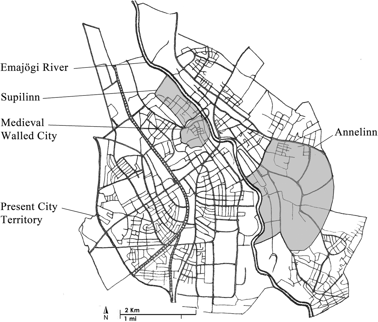
Study area map. Source. Created by the Authors and Elnaz Haj Abotalebi.
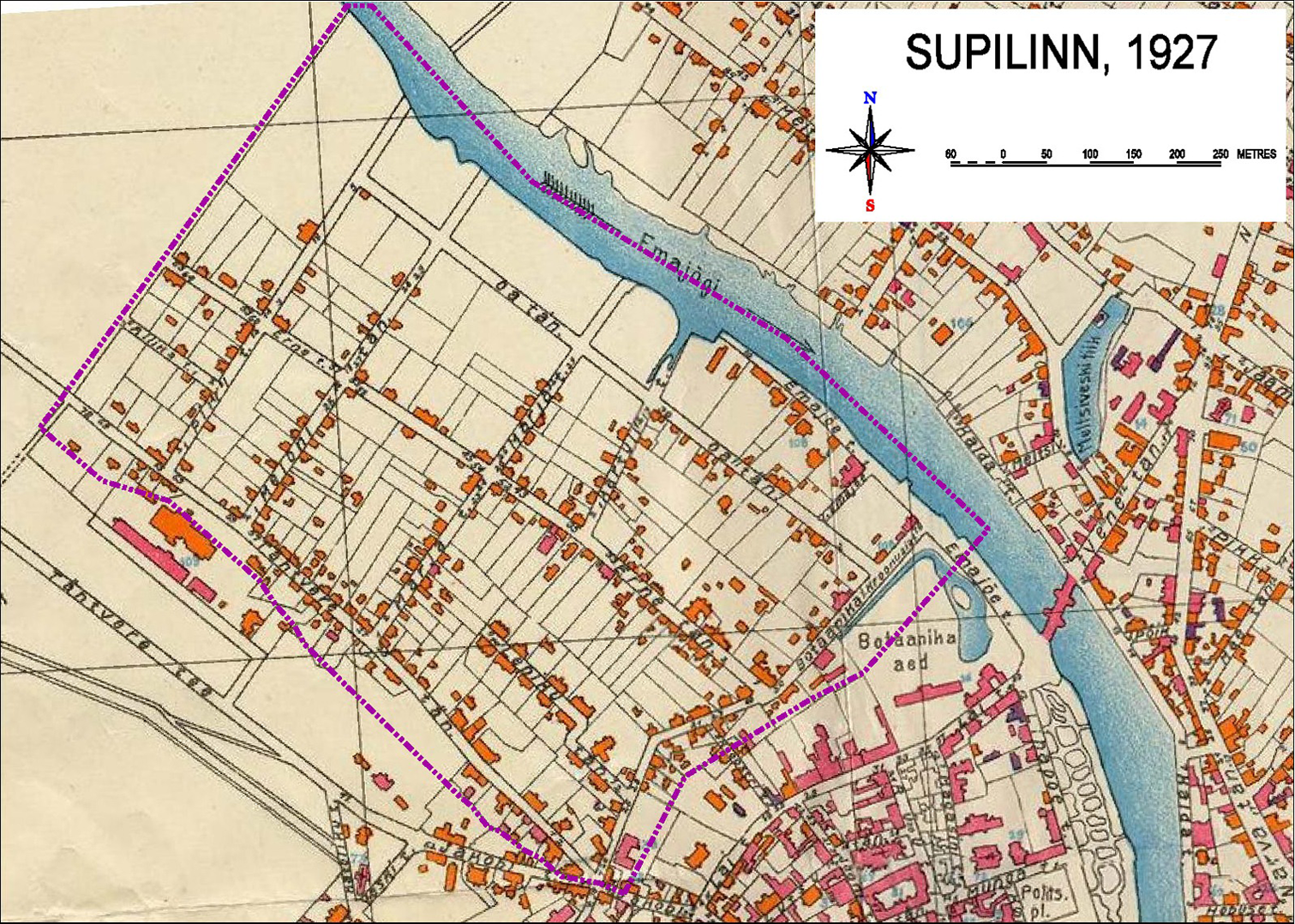
Map of Supilinn, 1927. Source. Reprinted from the original plan available from Tartu City Government, Estonia.
Supilinn 43 is a residential district located between the city center and land that has never been built upon (where there is now an outdoor recreation area). Several street configurations exist in Supilinn: some streets were developed organically to follow natural contours of the land 44 and other streets were planned orthogonally to provide access to properties (see Figure 3). 45 Property boundaries date from the late eighteenth century (according to the earliest available maps). 46 During the ensuing years, properties have continuously been subdivided; however, the historical configuration of individual properties still dominates: the shorter border fronts the street and the longer border stretches to the center of the city block.
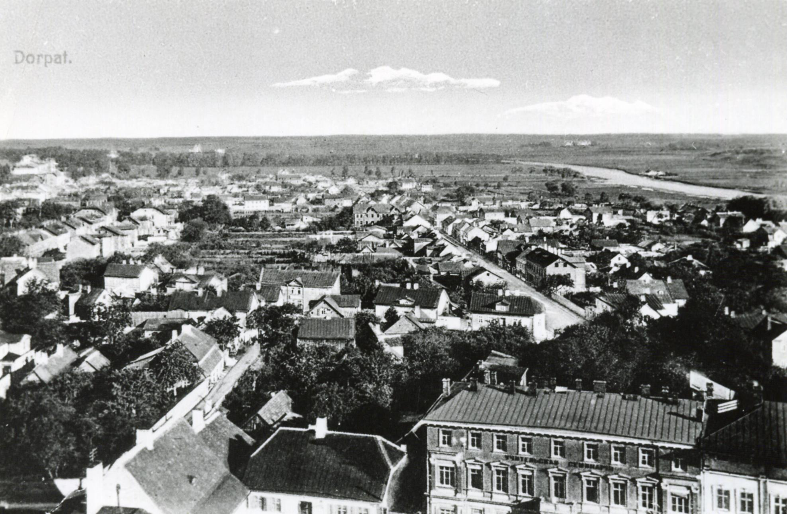
View of Supilinn looking northward from the tower of St John's Church (Jaani Kirik), circa 1920. Source. Reprinted with permission from the Tartu City Museum, Estonia.
Supilinn was spared in both World War I and II. In the interwar period of the Republic of Estonia, construction in Supilinn progressed slowly (approximately one building per year), a pace that continued throughout the Soviet occupation until 1991. Today, two-thirds of the buildings in Supilinn (not including sheds, garages, and other outbuildings) date from the premodernist period (ending in the late 1920s), 15 percent date from the early modernist period (late 1920s through late 1950s) and the remainder, 15 percent, date since the modern period (late 1950s to the present). 47 Supilinn has preserved relatively large properties (often 2,000 to 6,000 square meters) that were previously used for gardening; since domestic gardening has mostly disappeared, ample space is available for additional construction.
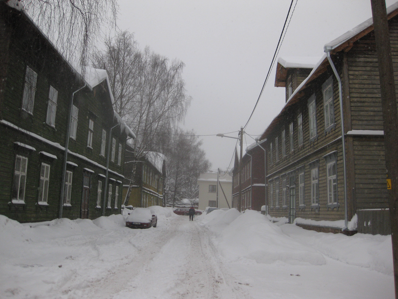
Residential parcels have always dominated land use in Supilinn. About three-quarters of the buildings are small, one- to two-story, sometimes with a third floor loft, with up to ten apartments per building. The remaining quarter of the buildings is detached single-family houses. 48 The buildings typify traditional wooden construction. In the nineteenth century, compulsory facade regulations enforced classical principles of symmetry and rhythm. See Figure 4.
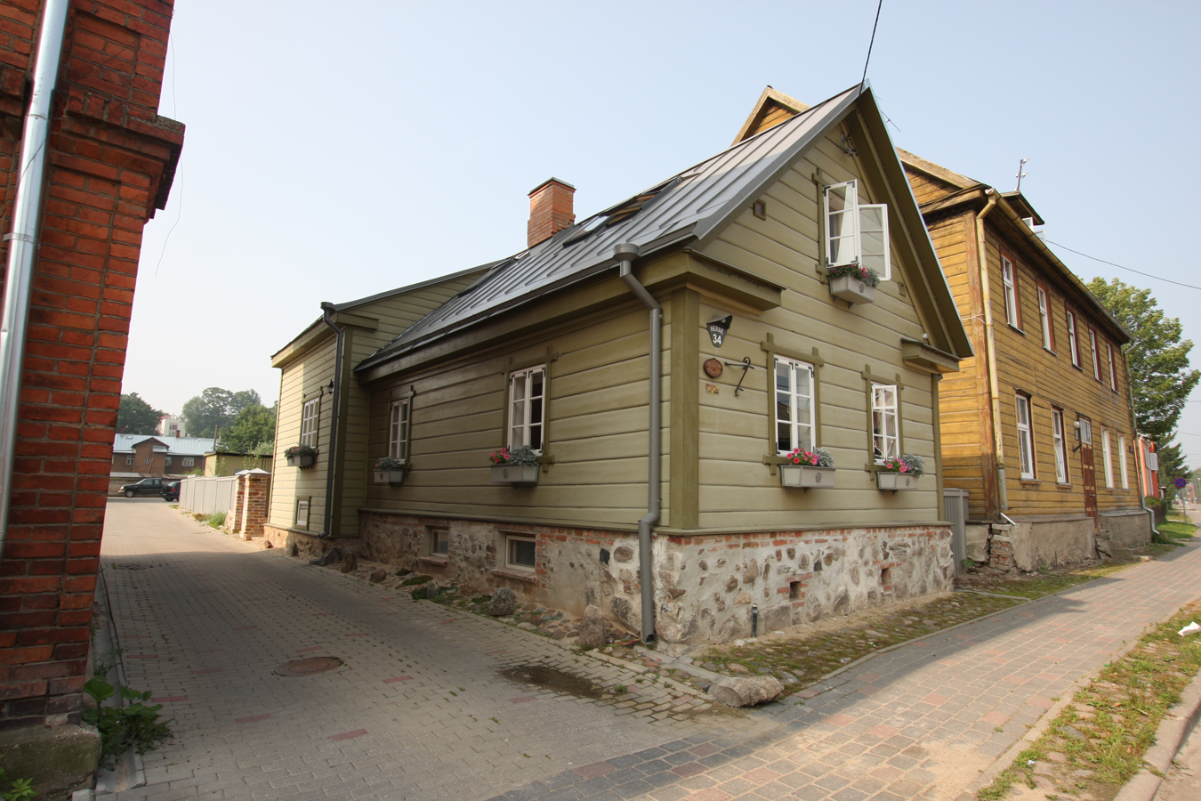
A private residence in Herne Street, 2010. Source. Mart Hiob.
From as early as the 1920s, there was a tendency to view districts of historic wooden houses as undistinguished and of little value. 49 Even when the Tartu city core (or “Old Town”) became protected in 1973, wooden houses on its perimeter were considered valueless. 50 Toward the end of the Soviet occupation, it was viewed that wooden houses gave positive value to districts; this was reflected in interest in preserving wooden houses but only when new construction was more expensive. 51
Analysis
In the next section, we organize a comprehensive sequence of written plans for Tartu in the twentieth and twenty-first centuries to demonstrate the evolution of town planning ideology that occurred in this small post-Soviet city. From the 1940s through the 1980s, town planning was carried out according to prevailing Soviet town planning practices. We note that metropolitan building patterns in urban physical environments and town planning ideology in Estonia show some similarities to norms of the western world, despite different political environments. 52 The sequence of plans is summarized in Table 1 and synthesized in considerable detail in the following section.
Evolution of Town Plans in Tartu, Estonia.
aState project design institute Estonprojekt (author A. Soans), Tartu linna keskrajooni punaste joonte projekt (The project of street corridors of Tartu city center), Estonian architecture museum, item EAM 3.1.034, Tallinn, Estonia, 1945. bArchitecture project design and planning center of Soviet Estonia (author P. Tarvas), Tartu linna planeerimise üldplaan (General plan of Tartu city), Estonian architecture museum, item EAM 3.1.237, Tallinn, Estonia, 1945. cState project design institute Estonprojekt (author A. Soans), Tartu linna planeerimise ja hoonestamise projekt (generaalplaan) (Project of planning and construction of Tartu city (general plan)), Estonian architecture museum, item EAM 3.1.523-526, Tallinn, Estonia, 1947. dState project design institute Estonprojekt (author A. Soans), Tartu linna planeerimise ja hoonestamise projekt (Project of planning and construction of Tartu city), Archives of Tartu city government, planning and land management department, Tallinn, Estonia, 1956; State project design institute Estonprojekt (author A. Soans), Tartu linna planeerimise projekt (Project of planning of Tartu city), Archives of Tartu city government, planning and land management department, Tallinn, Estonia, 1959. eState project design institute Eesti Projekt (authors of architectural sections V. Solomatina and H. Reissar), Tartu generaalplaan (General plan of Tartu city), Archives of Tartu city government, planning and land management department, Tallinn, Estonia, 1963. fState project design institute Eesti Projekt (authors of architectural sections M. Meelak, M. Port, O. Zhemtshugov, R. Kivi, Tartu generaalplaan (General plan of Tartu city), Archives of Tartu city government, planning and land management department, Tallinn, Estonia, 1976. gKivi, Detailed plan of Tartu old town protection zone. hState project design institute Eesti Projekt (author K. Voolaid), Tartu Supilinna rekonstrueerimise kontseptsioon (Reconstruction conception of Supilinn in Tartu), Archives of Tartu city government, planning and land management department, Tallinn, Estonia, 1986. iTartu City Council, Tartu linna üldplaneering aastani 2012 (Comprehensive plan until 2012 of Tartu city), Act of Tartu city council no. 99, October 6, 1999. jTartu City Council, Supilinna linnaosa üldplaneering (Comprehensive plan of Supilinn borough), Act of Tartu city council no. 88, October 18, 2001. kTartu City Council. Tartu linna üldplaneering (Comprehensive plan of Tartu city), Act of Tartu city council no. 125, October 6, 2005.
A succession of political environments in Estonia included the Tsarist period (1710 to 1918), the Republic of Estonia (1918 to 1940), the first Soviet occupation (1940 to 1941), the German occupation (1941 to 1944), the Soviet occupation (1944 to 1991), and the Republic of Estonia (1991 to present). Despite such profound governmental changes, we find surprising continuity in the creation and maintenance of the built environment. For example, Tartu city architect Arnold Matteus (1897–1986) held the office from 1926 to 1935 and from 1941 to 1960 through Estonian, German, and Soviet leadership in Estonia. 53
During World War II, Tartu was twice at the frontline, first in 1941 when the Soviets retreated and then in 1944 when the Soviet army returned. Both occasions resulted in extensive destruction evidenced by large areas in the city center that remain empty. Fortunately, Supilinn was hit sparsely: fewer than ten buildings were destroyed. 54 Even while World War II still waged, a discussion about how to rebuild Tartu had begun. Some town planners saw reconstruction as a golden opportunity to organize a better city on the ashes of bombed blocks. 55 Others suggested the urgent dismantling of all unwanted districts including Supilinn. 56
During the interwar period, town planning concentrated only on newly developing districts. Town planning efforts in Tartu started in earnest immediately after the German occupation was exchanged for Soviet occupation in 1944. Since Tartu city architect Matteus remained in office during this political transition, many of the town planning ideas put forward during the years of Estonian Republic and German occupation survived.
Phase I: 1940s to 1960s
During an era of extensive reconstruction planning for war-ravaged cities in Europe, a conceptual town plan for Tartu was published in 1945 and updated three times during the following six years. Preliminary plans from December 1944 57 as well as later developments 58 and modifications display traits of Stalinist utopian reconstruction. The characteristic system of symmetry and vistas surrounding focal points at street intersections and emphasis on monumental public facilities (such as government buildings and recreation facilities) is visible throughout the plan. Significant physical changes were envisaged for Supilinn, even though the street network was generally maintained (unlike the 1944 plan where new streets were proposed). Northwest of Supilinn, a large outdoor sports complex was planned and major access roads to the city center were added.
A comprehensive plan for Tartu completed in 1956 was published both in Estonian and Russian and undertaken by Estonprojekt, one of three state-run project design institutes in Estonia, in cooperation with the local administration. 59 The plan calls for complete demolition of all buildings and roads in Supilinn and Stalinist reconstruction of the district, featuring large superblocks and broad streets. Three primary land uses (two-story buildings, occasionally three-story buildings, and one- to two-story buildings and green areas) for Supilinn are designated in a color-coded land use map. Two principal arterial streets meet at a key intersection in Supilinn at an appropriate place for a monument, providing rich opportunities for urban vistas. Adjacent to the district, a brewery, one of the chief industries in Tartu, was to be expanded, consuming space in Supilinn formerly occupied by residences. However, building detail is not shown. A green corridor is planned along the Emajõgi River adjacent to the botanical garden in the south, and recreational and sports facilities in the north of the district.
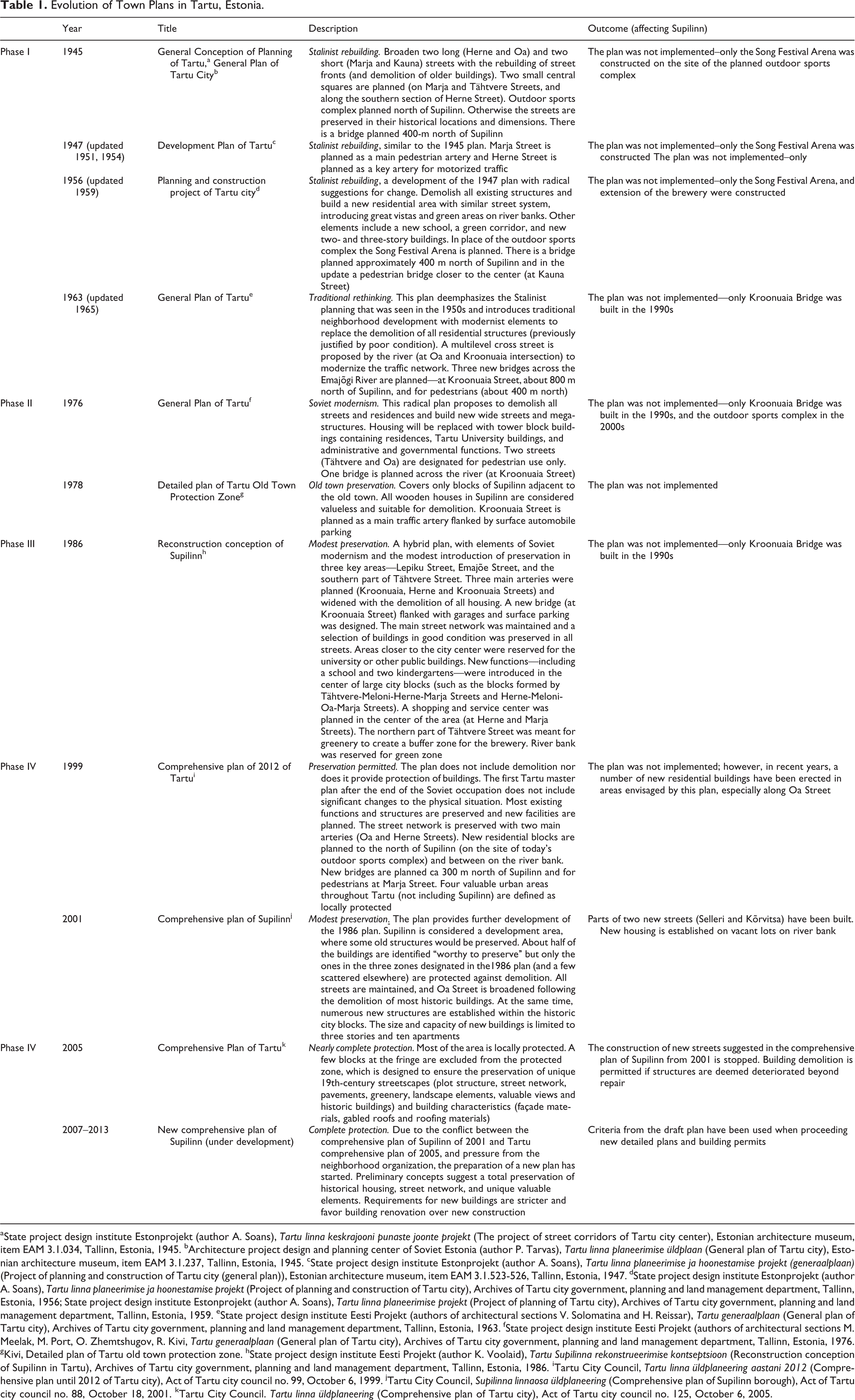
Three years later, in 1959, a revision of the plan was published, which provides greater detail about certain aspects of the 1956 plan. 60 The revision preserves a public bath building, proposes two bridge crossings (one for automobiles and one for pedestrians) north of Supilinn and specifies that the recreation area should include a ski jump tower, an amphitheater, and several restaurants. At the intersection of two planned main streets (Herne and Marja) a central monumental element is added (see Figure 5).
The planning project of Tartu City (General Plan), 1959. Source. Reprinted from copies of the original plan available from Tartu City Government, Estonia.
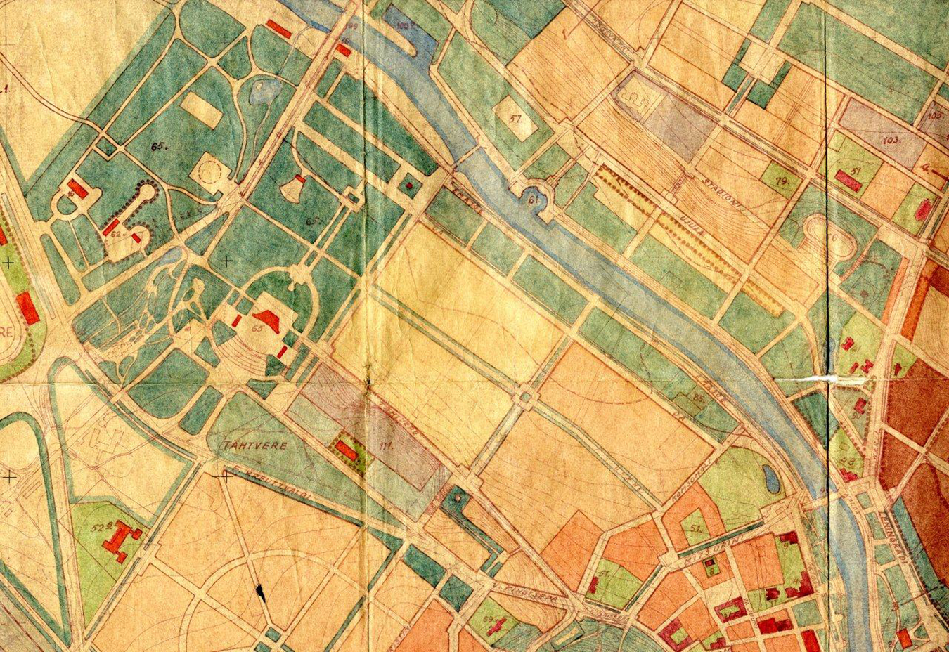
Almost twenty years after the first plan during the Soviet era, a new Tartu city general plan was undertaken in 1963. 61 This plan places lesser emphasis on Stalinist features, such as monumental squares at street intersections, that appeared a decade or two earlier. However, the 1963 plan possesses more traditional features than modernist features. Supilinn was planned for strictly residential use (see Figure 6). A technical review of the existing residential buildings throughout Supilinn concludes that most are in poor condition (on a three-level scale), and this assessment is used to propose the demolition of all residential structures. The plan further calls for the widening of selected streets, and buildings throughout the district were planned to be 1- to 1.5-story residential structures. 62
General plan of Tartu City, 1963. Source. Reprinted from copies of the original plan available from Tartu City Government, Estonia.
Phase II: 1970s
In the late 1960s and early 1970s, modernist ideas inspired by Le Corbusier’s proposals in Paris and elsewhere 63 become dominant in the Soviet Union. In Estonia, new suburban districts of large apartment blocks were planned in Tallinn (Mustamäe, Väike-Õismäe and Lasnamäe), Tartu (Annelinn), and other larger towns. The modernist approach required new kinds of urban infrastructural organization because streets were dissolved and towers were scattered across park-like settings. Residential areas were strictly separated from business and industry while roadway networks were designed to provide convenient automobile access.
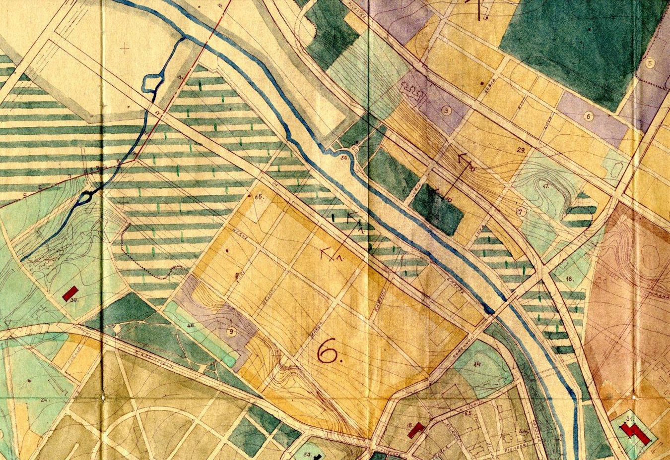
The most radical development plan, the General Plan of Tartu, appeared in 1976 and called again for the demolition of all streets and residences in Supilinn, replacing them with new broad streets (some reserved exclusively for pedestrians) 64 and mega-structures (see Figure 7). 65 Supilinn would contain a mix of uses: approximately 40 percent of the land was reserved for housing (tower blocks at least four stories high 66 ), 30 percent for university buildings, 25 percent for greenspace, and 5 percent for public rights-of-way. As in previous plans, the brewery is enlarged. The only building to be preserved is a public bath (in Emajõe Street). In addition, there is a planned stadium in the outdoor sports complex at the northern end of Supilinn.
Zoning map of Supilinn and Tartu City Center (Proposed), 1976. Source. Reprinted from copies of the original plan available from Tartu City Government, Estonia.
Four years later, the Detailed Plan of Tartu Old Town 67 specifies the condition—and potential—for protection and renovation of historically valuable buildings and other structures in the historic core of Tartu. In the plan, all wooden houses in Supilinn are considered valueless and suitable for demolition, including houses within the protected zone. Estonian architect Mart Port echoed the sentiment of Soviet leadership about demolition of historic dwellings: “only after satisfactory solution of the housing problem will it be expedient to tackle the next job: the replacement of two- to three-story wooden houses, which are inferior in terms of architectural value, amortized and without amenities by modern buildings.” 68
Phase III: 1980s
By the early 1980s, nearly all low-cost undeveloped land within city boundaries suitable for new apartment blocks had been used in Estonia, and new locations for housing were needed, prompting proposals for the reconstruction of historic districts. 69 Echoing the years immediately following World War II, many people still lived in cramped quarters. 70
The Conceptual Plan for the Reconstruction of Supilinn was completed in 1986, and this would be the last written plan before the disintegration of the Soviet Union. 71 Previously, the treatment of Supilinn had been part of larger comprehensive plans, but the 1986 planning effort suggests recognition of Supilinn as a distinct district demanding a dedicated planning exercise. The result is a hybrid plan, with elements of Soviet modernism and, in a departure from town planning in Estonia during the 1960s and 1970s, modest elements of preservation. This is the first plan since the 1940s in which Supilinn is not slated for entire demolition.
The plan calls for much demolition within Supilinn, however building preservation occurs in three key areas: a centrally located ensemble of historic wooden apartment buildings with unified townscape (Lepiku Street, see Figure 8), the riverfront on the north side, 72 and on the southern side (Tähtvere Street between the city center and Marja Street). These three areas are distinguished as an “architecturally valuable milieu to be preserved” according to contemporaneous town planning language. Apart from these three key areas, the wooden buildings in Supilinn are not considered valuable. Perhaps more importantly, the buildings are mostly deemed to be in poor condition, and so they are targeted for demolition.
Historic wooden houses with Art Nouveau Detailing on Lepiku street, 2010. Source. Daniel Baldwin Hess.
New buildings proposed for the district in this plan did not include tower blocks; instead, smaller buildings would prevail, and they would include a shopping center (grocery, restaurant, laundry, post office, and household goods store), a community service center, kindergarten, and new buildings for university (or similar public use). City blocks were large and the center portion of city blocks (rear gardens of residential plots) would be developed with buildings such as schools and kindergartens. The main street (Herne) was to be completely demolished, and a new wider street was to be established.
Implementation Prior to 1991
Change of urban landscapes is a two-step process, first planned (to meet social, economic, and political demands of the day) and then executed (by way of implementation of plans). This study examines plan implementation and thus helps us to understand the mechanisms of urban development.
During the 1950s, 1960s, and 1970s, city plans were officially held in secrecy and no public display was allowed. The official concern was that antigovernment forces—so-called public enemies and foreign agents—could use the plans for sabotage. A few glorified drawings of proposed building schemes were made available for public consumption. Planning documents, which included a large 1:10,000 scale color-coded land use map, technical infrastructure map, and other thematic maps and accompanying text, were shared freely among officials even though the copies were numbered and tracked. However, the de facto degree of secrecy was questionable since the plans were working documents needed in everyday decision making. 73 Military installations were not depicted on the plans and town officials had little knowledge about the intentions of the military. Town governments had little influence on military planning and therefore the areas under administration were simply excluded from ordinary development. Although military zones were restricted, citizens could visit. 74
Ambition for urban reconstruction during the Soviet years outstripped available resources, and none of the plans reviewed in Table 1 was implemented in full (and few were implemented even in part). Investments in Supilinn during the Soviet era were minimal; for example, sewerage and water supply systems were reconstructed, some street alleys were planted, and two streets were paved with asphalt and others with gravel (which perhaps worsened street conditions because surfaces were previously cobblestone 75 ).
The Soviet-era plans envisaged grand changes in urban structure. Similar to other realms of Soviet society, town plans were unrealistic and bordered on utopian. The utopian aspiration reached its peak in the 1976 plan, which laid out a complete revision of both housing and street networks according to new modernist principles in a manner that made little use of existing structures. 76 The plan firmly reflects modernist influences in the form and position of buildings. The Soviet system was dependent on central allocation of funds 77 ; funds were scarce and in a second tier town like Tartu, they were seldom used for rebuilding existing structures that still possessed some—even minimal—practical value.
Similarly, the plan of Supilinn (1986) was not implemented. 78 However, a new attitude displayed in the plan toward selective preservation of certain areas and lesser emphasis on mega-development demonstrates a change in town planning approach and is propagated in town plans produced during the next decades.
Considering the many town planning exercises that addressed Supilinn, little was implemented prior to 1991. From the Soviet period, only the construction of the Song Festival Arena can be considered a major investment. If we look to other pre–World War I neighborhoods bordering the town center of Tartu (such as Karlova, Toometaguse, Kastani, Ujula, etc.) we find similar patterns, with marginally higher levels of investment and thereby implementation of town building plans. Other residential districts in Tartu do not have natural boundaries as distinct as those enclosing Supilinn but generally they have higher building density. A demand for low-density development sites could have favored residential districts like Supilinn. In contrast, new neighborhoods established during the interwar period from 1920 to 1941 (for example, Tähtvere and Tammelinn) were generally not considered ripe for demolition. Instead, new buildings in established neighborhoods were added between existing structures—a practice of densifying using available land—or on the fringes.
In addition to a reluctance to demolish useable housing, geological conditions in Supilinn may explain a lack of large-scale land use change and reconstruction. It is difficult to construct buildings higher than two stories upon the ground in most parts of the district because a one- to eight-meter layer of peat and dirt rests in the ground upon a base of sand and sandstone. Construction costs were estimated to be expensive. 79 In addition, a high ground water level complicates building. Consequently, the foundations of historical buildings are constructed on floating wooden trunks resting in water (to avoid rotting). 80
Similar geological conditions occur in the adjacent Tartu city historical core 81 where little development took place during Soviet times. Modern construction techniques use boring to reach sturdy earthen layers beneath peat or, for smaller buildings, use plate foundations; both methods are more expensive than a traditional linear base beneath bearing walls. 82 Therefore, it would have been cost prohibitive to build apartment blocks, given the geologic conditions in Supilinn. 83 In addition, construction of new blocks of apartments required equipment—including large cranes—that did not fit within the narrow lanes of Supilinn.
In other pre–World War I wooden neighborhoods in Tartu, where geological conditions were more favorable for construction, a few large block of houses were erected. Generally, the demolition of old wooden structures took place only in connection with infrastructural change. For example, in Karlova, a district built densely with wooden buildings, a number of historic structures were demolished to construct the infrastructure for a new highway bridge, and new tower blocks were squeezed into existing city blocks—where demolition had already occurred—adjacent to the bridge.
Phase IV: 1990s and 2000s
Following the reestablishment of Estonian independence in 1991, responsibility for town planning was assumed by the municipality of Tartu. Though new national laws helped to institutionalize planning practice, there was a general apathy during the 1990s toward town planning; the passiveness was a legacy from the Soviet-era secrecy surrounding planning that discouraged participation. The first planning and building law, enacted in 1995, established a new framework for planning based on democratic participation and public procedures. 84 In Tartu, new development and redevelopment occurring after 1991 at first adhered to plans from the Soviet years. The political transition produced hardship; there was little capital available for investment and much demand for maintenance. After the end of Soviet rule, preservation of heritage gained support 85 but Supilinn was not included in a list of valuable urban areas.
The first Tartu comprehensive plan since reestablishment of independence was undertaken in 1997 and adopted in 1999. 86 Four protected districts were included in the comprehensive plan, but instead of establishing new guidelines for preservation practice (including site selection), the plan referred simply to the previous acts. The comprehensive plan does not reference three valuable streets in Supilinn mentioned in the 1986 plan.
Supilinn was regarded as an ordinary residential area where the number of inhabitants was expected to increase approximately 30 percent, and the 1999 plan addressed densification and reconstruction. 87 The Soviet plan for a main traffic artery between Supilinn and the old town was abandoned along with widespread demolition.
The general attitude toward Supilinn was indifferent, which was typical of a then widespread disinterest in town planning. The district was not viewed as worthy of protection, but at the same time it also was not subject to radical or even modest plans for alteration. Following the restoration of Estonian Independence in 1991, private land ownership was reinstated, and properties confiscated by Soviet leaders were restituted to the original owners or their heirs. The municipality owned a small share of land—streets, municipal institutions, and modest reserves. 88 Local and national governments imposed as few restrictions as possible and at the same time had to newly reckon with the legal rights of private landowners.
The comprehensive plan of Tartu in 1999 addressed certain deficiencies in the district but did not propose clear alternatives for the future. The plan did not have lasting influence on Supilinn, due primarily to the unpopularity of the district as a residential area in the 1990s. 89 The infrastructure in Supilinn was below minimum acceptable standards with gravel-paved streets without sidewalks and deteriorated water and electricity supply and wastewater management.
Continuity of Townscapes
Due to its proximity to the old town, recreational areas, and the Emajõgi River, Supilinn was regarded among Tartu officials as having great potential as a redeveloped residential area. The reputation of the district was enhanced by its residents—people connected with the university, artists, and even the city architect at the time—and the city government responded by initiating a new plan for Supilinn in 1997. 90
The comprehensive plan of Supilinn borough was adopted in 2001. 91 In the plan, a number of new streets were proposed for densification. A new residential area to the north of Supilinn was abandoned, where public use was proposed (similar to the 1976 general plan). Most buildings are designated as “worthy to preserve,” but preservation is not explicitly required. The three districts described in the 1986 plan are designated as valuable built environments. These areas are to be preserved and reconstruction plans must be approved by city government. New buildings are limited to three stories in height and ten apartments per building.
In general, the plan does not view Supilinn as a valuable area. It recognizes that there are a few valuable streets and some buildings that should be protected, but the overall approach both permits and encourages large alterations. Supilinn is considered a rundown district requiring major intervention to become an attractive residential area. Densification is a key solution for attracting new services and upgrading infrastructure.
The restitution policy of in the 1990s created a new class of property owners. Most property owners were also residents and sought to improve properties in Supilinn. 92 The owners wanted to avoid radically altering the plot structure or adding new buildings because they both regarded it as harmful to their property and they valued the historic environment. 93 The 2001 plan was opposed by many residents who did not approve of densification of the district. The Supilinn Society, a neighborhood organization formed in 2001, strongly opposed new structures and proposed the invalidation of the plan.
The 1999 Comprehensive Plan of Tartu 94 possessed several widely acknowledged shortcomings and a new planning process for the city began in 2003. In 2002, a new national planning law was adopted, which allowed designation of local valuable built environment or “milieu” areas (miljööväärtuslik hoonestusala in Estonian). Supilinn was mostly included in a newly designated “milieu” area. For the first time Supilinn was recognized to be a valuable area as an ensemble of buildings, streets, and all elements of the built environment that had survived from the tsarist period.
The new comprehensive plan of Tartu (2005) supplanted components of the 2001 comprehensive plan of Supilinn, 95 especially new streets that would alter the original plot structure and street network. The Supilinn Society requested the initiation of a new comprehensive plan for Supilinn to overcome the conflicts between two existing plans. In 2007, a new district planning process was begun by the city government 96 and the first draft was approved in 2012. 97 The plan is strongly oriented toward preserving structures (including housing, streets, and plot boundaries) dating from pre–World War II.
Inertia versus Implementation of Plans
Situating this study in Estonia allows us to consider continuity and change in a country that has been subjected to many ideological changes during the twentieth century. All major regime changes occurring in Estonia—in 1918, 1940, 1941, 1944, and circa 1991—were followed by promises from government leaders of change and implementation of new ideas. Throughout these eras, however, the power of the state reduced the likelihood that Estonians would reproduce built environments from the past. Under the political regime during state socialism, no constituency could demand renovation of Supilinn or any other neighborhood; now, however, most neighborhood residents strongly favor preservation. 98
Although during the Soviet occupation there were no restrictions introduced by property ownership (all real estate belonged to the state), the socialist system did not prioritize improving living conditions for its citizens. Therefore, a lack of resources in the housing sector was widespread in an environment of acute housing shortages.
There is no doubt that forces of change were strong in cities of the FSU, and diminished or diminishing fiscal resources produced a lack of capacity for urban expansion and a policy to construct new housing on virgin land instead of renovating existing urban districts. The inertia of the built environment also played a role during the mid-twentieth century, as an acute housing shortage made it impossible to temporarily relocate residents while older districts such as Supilinn could be razed for new construction. Geological conditions in Supilinn deterred demolition and replacement because the construction of large steel and concrete towers (for residential or municipal use) favored at the time would have been too costly.
Conclusion
In the current article, we have focused on unintended consequences of implementation of Soviet-era town plans in Tartu, Estonia. The Soviet provision and allocation system produced a “shortage economy” and introduced irrational forces into the housing system. 99 A housing shortage meant that residences were continuously occupied and were not abandoned as properties might have been in an active market housing system, when “trickle-down” dwelling units assume bottom positions on the housing ladder for acquisition by other groups. 100 We conclude that, during the Soviet years, a housing shortage was a major source for inaction. 101 In most cases, dwellings received only essential maintenance and were not modernized when required. Old wooden housing areas exist in other Estonian cities (Pärnu, Tallinn, Rakvere, and Viljandi), 102 but few are so completely and authentically preserved as Supilinn. 103 After decades of limited choice during the Soviet era, there has now been, during the last decade, construction of detached homes on the periphery of cities that provide more housing options for those with sufficient means. 104
An overview of town planning activity (which was largely unexceptional) and implementation (which was modest) from 1944 to the present sheds light on the ensemble of pre–World War I urbanism in Tartu and suggests that Supilinn was threatened with total demolition consistently until the 1980s, although a sequence of demolition plans was never carried out. In practice, change in the built environment usually takes place in marginal or incremental ways, 105 and complete demolition and reconstruction of Supilinn would have been radical. Soviet authorities in Estonia did not generally succeed in implementing modernist reconstruction plans within urban districts dominated by historical wooden buildings in the way that officials in nearby Nordic countries of Sweden, Finland, and Norway rebuilt comparable districts.
The preceding discussion addresses our research question and suggests key explanations for a failure to implement official written plans: a lack of resources for plan implementation; a shortage economy insured that Supilinn was continuously occupied and never abandoned or ruled obsolete; general disregard for historical wooden areas; and a focus on new housing and new districts. In Supilinn, difficult geological conditions also contributed to inaction. Since the entire district was designated for redevelopment, there was little interest in reconstruction and rebuilding even though there was plenty of space between existing buildings. As a result, the authenticity of the original urban space is preserved. Consequently, we argue that the legacy of written plans exerted an implicit rather than an explicit influence over local planning and development. Officials paid little attention to Supilinn, as it was a small district housing 3,000 people and large districts (such as new mikrorayons housing 10,000 or more people) were of greater concern. Tartu had experienced extensive destruction in World War II (about one-fifth of the city was demolished 106 ), and Soviet-era reconstruction was focused on rebuilding damaged areas and thereby helped to spare preserved historical districts.
Wooden housing areas were viewed as a necessary evil of urban life until all Soviet citizens would receive new apartments in modern concrete buildings. That is, wooden districts were reconstructed only when they stood squarely in the way of greater development plans. 107 We find significant town planning activity in Tartu—with a major plan (and subsequent addenda and revision) produced at least every decade, consistent with a Soviet ambition to reorder cities and societies—yet virtually no implementation in existing neighborhoods for the reasons given above.
The evolution of town planning in Tartu demonstrates how planning ideology has changed and diffused throughout the twentieth century. Modernist reconstruction and city renewal were subject to heavy criticism in western countries in the 1960s and 1970s when Jane Jacobs’ The Death and Life of Great American Cities (1961) was published and the iconic Pruitt-Igoe housing complex was demolished in St. Louis, Missouri. 108 However, Soviet town planning ideology did not abandon modernism before the disintegration of the political system in 1991. The Soviet system did not accommodate the democratic features of new town planning ideology like collaboration and public engagement.
After Stalinist architecture and town planning fell from favor, modernism seemed to offer Soviet authorities simple and clear solutions to immense housing shortages following World War II. In addition, well-respected Estonian architects 109 traveled to the west on state-sponsored trips. For example, An Architect’s Trip to England in 1966, 110 which was widely read in Estonia, describes contemporaneous development in London from an architect’s viewpoint, summarizing popular thoughts of the day about British town planning and the built environment. Such diffusion of knowledge from one country to another had an effect on architecture and town planning, although the effect may have been ideologically altered due to the status of Estonia as a Republic of the Soviet Union.
A notable change in town planning practice occurred between 2001 and 2005—significantly delayed compared to western Europe and the United States and more than ten years after Estonian independence in 1991—of moving in opposition to Soviet-era recommendations for the reconstruction of Supilinn. Consequently, current passion among many for preservation, and a vision of planning that simultaneously looks forward and backward in time, stands in stark contrast to the abstract modernist principles of the 1960s, 1970s, and 1980s that are vividly expressed in plans from those decades. At the same time, the image of Supilinn as a residential district has improved remarkably during the last decade. 111 Signs of gentrification 112 suggest that renewal is likely to preserve the material content of Supilinn while simultaneously threatening its social diversity. However, it is likely that, in the coming years, the Tartu city government will invest little capital in the district, and most improvements will be privately funded. 113 We argue that future plans for districts such as Supilinn, the larger cities in which they lie, and even metropolitan areas and regions, must be developed with an understanding of the underlying mechanisms that structured the geography of the built environment of cities before, during, and after state socialism.
Footnotes
Acknowledgment
Michael Gentile provided helpful insights during the development of this research and anonymous reviewers provided comments on an earlier draft.
Authors’ Note
When this research was conducted, Daniel Baldwin Hess was a Fulbright Scholar at Tallinn University of Technology–Tartu College. The Fulbright Scholar program is sponsored by the US Department of State and administered by the Council for International Exchange of Scholars, a division of the Institute of International Education.
Declaration of Conflicting Interests
The author(s) declared no potential conflicts of interest with respect to the research, authorship, and/or publication of this article.
Funding
The author(s) received no financial support for the research, authorship, and/or publication of this article.