
Abstract
Development pressures threatening northwestern Baltimore County, Maryland, in the early 1960s led to the creation of the private Valleys Planning Council, which commissioned University of Pennsylvania Professors Ian McHarg and David Wallace to produce The Plan for the Valleys, featuring McHarg’s approach of ecological determinism to locate development and preserve land, with Wallace designing the type and density of development. We analyze The Plan’s development and land protection elements and the County’s subsequent use of an urban growth boundary, agricultural zoning, and conservation easements. Although a catalyst for landscape protection, The Plan’s substantial development elements were never built.
Urban sprawl was a recognized and still emerging phenomenon in America’s metropolitan regions in the early 1960s. In his landmark 1961 book, Megalopolis or the Urbanization of the Eastern Seaboard, Geographer Jean Gottmann described sprawl as a “continuous stretch of urban and suburban areas” and as the “mushrooming suburbs filling in the spaces between the larger cities.” 1 The Exploding Metropolis, edited by William H. Whyte, had appeared in 1958 and identified the twin problems of urban decline and suburban sprawl. 2 But local governments were doing little to control sprawl. 3
Restrictive rural zoning, limits on extensions of sewer and waterlines, and the preservation of open space were in their infancy and not yet popular tools for planners and local governments. Local governments did not adopt restrictive agricultural zoning until the 1970s. 4 The first urban growth boundary to limit sewer and water extensions was created in 1958 in Lexington-Fayette County, Kentucky, and remained the only one until Baltimore County created an urban growth boundary in 1967. 5 A small number of private nonprofit land trusts had acquired conservation easements to preserve land, but there were no state or local government programs to acquire conservation easements. 6
There were also few good models for greenfield development. Post–World War II Levittowns had deposited thousands of homes at a time on the suburban landscape, and Frank Lloyd Wright’s Broadacre City called for a house on an acre of land with a car in the garage: the epitome of low-density suburban sprawl. 7 Perhaps the most famous models were the new towns of the United Kingdom, modeled after Ebeneezer Howard’s garden city, along with the three garden cities that had been built in the United States prior to World War II (Greenbelt, Maryland; Greenhills, Ohio; and Greendale, Wisconsin). Howard envisioned a largely self-contained city of 30,000 people in harmony with nature. 8 Yet, the postwar new towns of the United Kingdom far exceeded this population size and required significant government funding. 9 The private sector had not embraced the construction of new towns.
In the absence of rural land protection and sensitive greenfield development, new interstate highways had made American suburbs and the countryside easily accessible by car; new sewer and waterlines helped to transform vast acreages into single-family house lots; and federal housing policies encouraged home construction and home ownership, primarily on former suburban and rural greenfields. 10 Open space, farmland, forests, and natural areas gave way to scattered subdivisions, large houses on large lots, and commercial strip development in awkward, expensive to service development patterns. Planners, local governments, and concerned citizens struggled to accommodate growth and yet maintain the open lands that made the countryside attractive. 11
One such struggle emerged in Baltimore County, Maryland, in the early 1960s. It is an unlikely story of how a powerful citizens’ group, the Valleys Planning Council (VPC), saw the need for a visionary plan to respond to suburban development pressures. The VPC commissioned University of Pennsylvania Professors Ian McHarg and David Wallace to create a plan for three valleys in the rural northwestern part of the county.
The Plan for the Valleys (PFV, 1964) advocated a balance of development and land preservation. But the implementation of the plan then suffered the vicissitudes of landowner reaction and Baltimore County politics, and the development elements were never realized. 12 The ideas and techniques in The Plan have proven both influential and fundamental for development suitability analysis as the core of a land use plan: regional ecological and physiographic determinism, population growth projections, and optimum development levels.
The recommendations of The PFV, together with the novel public–private collaboration between the VPC and Baltimore County planners, led to: The Urban–Rural Demarcation Line (URDL) in 1967—an urban growth boundary that limited water and sewer extension, Resource Conservation (RC) Zoning begun in 1976 which now protects more than 135,000 acres of farmland, and The preservation since 1979 of more than 60,000 acres of farmland through the acquisition of conservation easements.
13
Today, Baltimore County is famous for having some of the most closely planned and protected countryside in the United States. 14
Ian McHarg (1920–2001) and David Wallace (1917–2004) formed a business partnership upon receiving the commission for The PFV. And the business lives on today as the prominent Philadelphia planning and design firm of Wallace, Roberts, and Todd. Wallace was an established planner and architect with professional experience in Maryland. McHarg had created a unique ecology-based curriculum at the University of Pennsylvania’s Department of Landscape Architecture and Regional Planning in the late 1950s. The PFV would play an important role in McHarg’s rise as an internationally renowned environmentalist and was featured in McHarg’s seminal environmental planning book Design with Nature (1969); Wallace, on the other hand, retained doubts about The Plan to his death. 15
Baltimore County 1960: The Coming Tide
Baltimore County in 1960 was a largely rural and agricultural region despite a population of almost 500,000. 16 The county surrounds Baltimore City like an open wrench, and the city has long been unable to annex county land (Figure 1). The county’s physiography ranges from a coastal region along the Chesapeake Bay to its southeast, to a piedmont region approaching Pennsylvania to the north. Northwest of Baltimore City is a ridge and valley region, which contains the Worthington, Green Spring, and Caves Valleys (Figure 2).
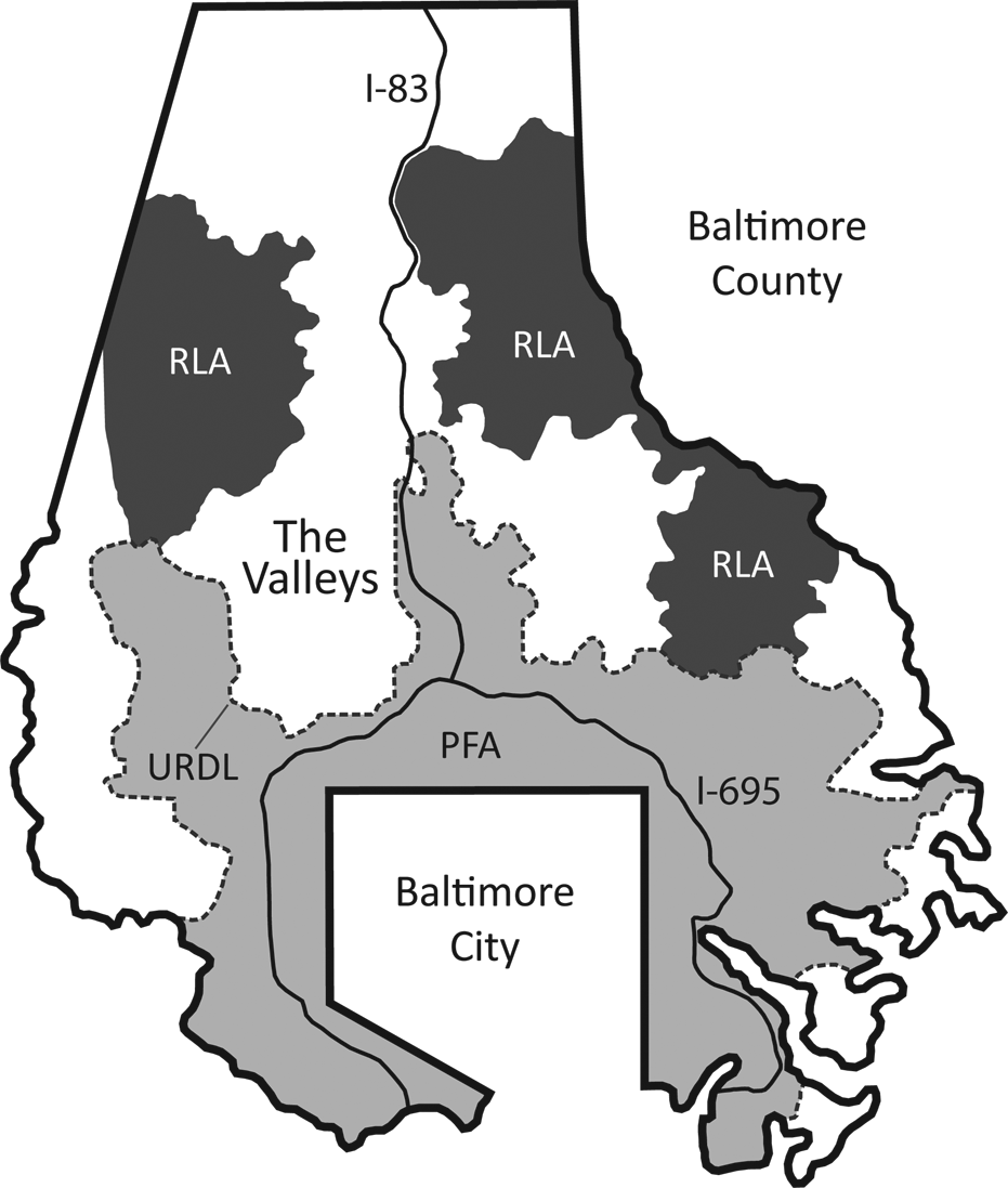
Overview of Baltimore County, Maryland. The Valleys to the northwest of Baltimore City and the proximity to I-83 and I-695. URDL is the Urban–Rural Demarcation Line created by Baltimore County in 1967. The URDL defines the outward boundary of the Priority Funding Areas (PFA) in gray. These are the primary development areas of Baltimore County, delineated as part of Maryland’s 1997 Smart Growth legislation. Rural Legacy Areas (RLA) are the high priority land preservation areas identified by Baltimore County, also as part of the 1997 Smart Growth legislation. Source: Graphic by Ethan Daniels, used by permission.
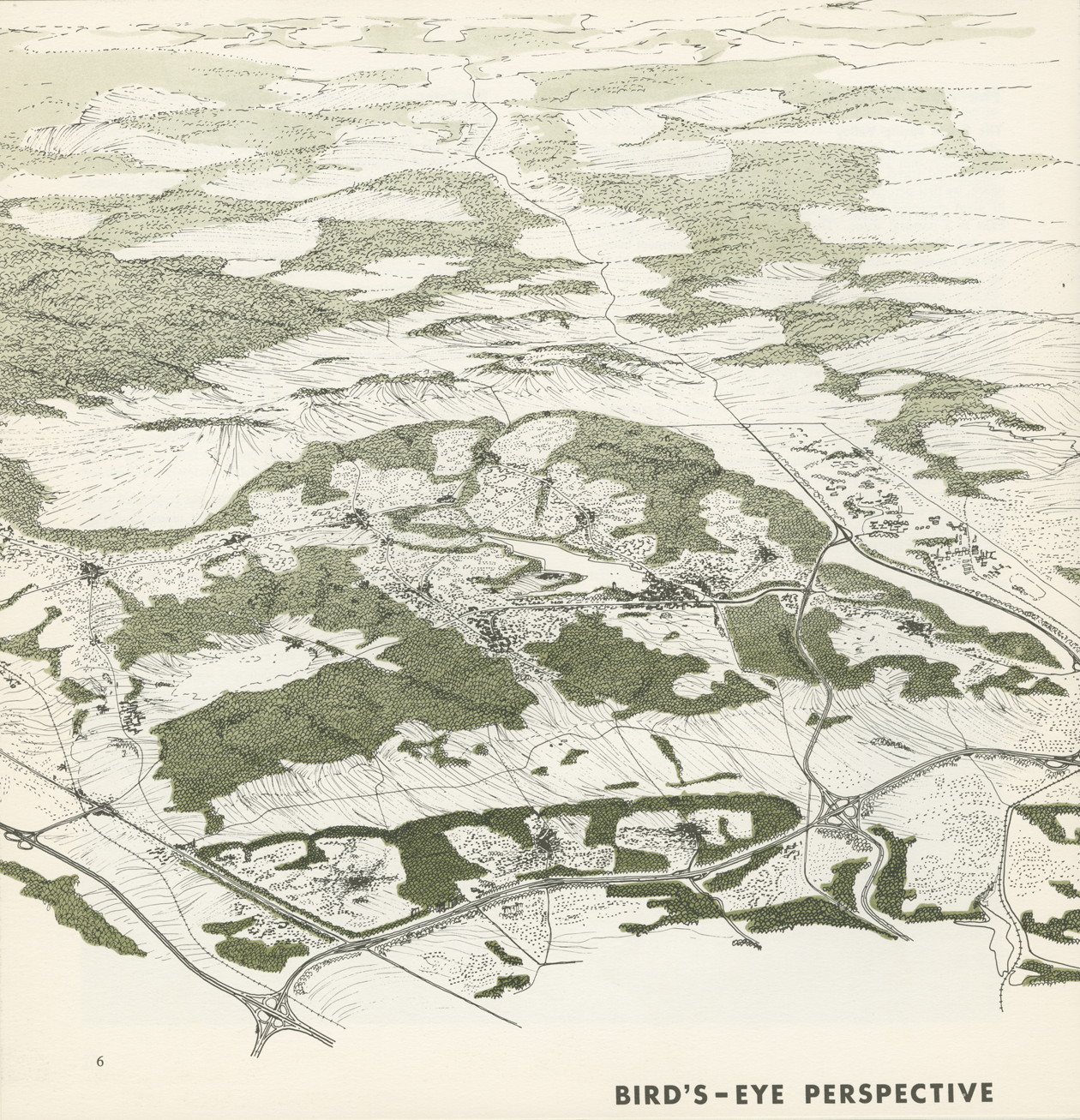
The Worthington, Green Spring, and Caves Valleys, bird’s-eye view. Source: The Plan for the Valleys (1964). Credit: Ian L. McHarg Papers, The Architectural Archives, University of Pennsylvania.
In 1960, Baltimore City was in a state of “precipitous economic decline,” 17 with urban flight facilitated by the construction of the Baltimore Beltway (I-695). In 1961, the northern stretch of the Beltway was completed. 18 The adjacent three valleys had almost no protection against development. Nearly all of the land was zoned for one-acre single-family house lots. A particular threat to the residents in the Worthington Valley was the Jones Falls Expressway, which emanated from central Baltimore City. Once the Expressway connected to Interstate I-83, it would place the Valley within a twenty-minute drive of the city. 19 Residents feared that sewers would follow. 20
The Rise of the VPC
The VPC began as the Green Spring and Worthington Valley (GSWV) Council, founded in 1962 by landowners who took an enlightened self-interest in protecting the countryside. Renamed the VPC in the mid-1960s, the VPC has long advocated “a balanced and rational use of the land.” 21 Its initial mission area was seventy-nine square miles of northwestern Baltimore County (see Figure 1). 22
The original 250 members consisted of some “wealthy landowners” 23 and “leading citizens.” 24 They were also a mixed lot. David Wallace and William McDonnell described their first meeting with VPC members in March 1963 as “an interesting group with a few big landowners, but mostly people on three to ten acres who liked to look at open land.” 25 The VPC was not a grassroots organization in the conventional sense, for certain members circulated within influential business and political networks. Many worked in Baltimore City, and a number were foxhunters, who understood that the three valleys could not merely be made hunting preserves. Minutes from the first meeting of the VPC in 1962 showed that the VPC believed “its own ideas for development will be recognized and adopted by the County government.” 26 To achieve this, the VPC needed a plan.
Baltimore County Executive Spiro T. “Ted” Agnew, who later became Governor of Maryland and Richard Nixon’s Vice President, attended the first VPC meeting. Agnew not only promised his personal support but added that he “would do everything in his power to see that all County agencies involved cooperated to the fullest extent with the members of our Council, as well as with our professional planners.” 27 The County Executive’s attendance at the meeting attested to the clout of the VPC’s founding members. Yet, Agnew had reservations about a takings issue if the region were downzoned from one-acre zoning, and he worried that “if we accept and back this plan, every Tom, Dick, and Harry who ever took a course in drafting will be making plans across the County.” 28 Despite this equivocation, Agnew had “in principle” supported the idea of a private plan and therefore had also given his blessing to cooperation between the VPC and Baltimore County planners. 29
Wallace–McHarg Associates
To come up with a plan for the three valleys, the VPC turned to David Wallace. Wallace had earned a PhD at Harvard and then served as the executive director of the Philadelphia Development Authority. In 1955, famed developer James Rouse founded the Greater Baltimore Committee, a powerful business advocacy group, and brought in Wallace as executive director. Soon, Wallace was placed in charge of the Charles Center renewal project in Baltimore City. Completed in 1957, this extensive twenty-two-acre redevelopment included a centerpiece building designed by Mies van de Rohe as well as plazas, elevated walkways, and underground parking. 30 Jane Jacobs wrote a favorable review in Architectural Forum entitled “A New Heart for Baltimore.” 31 Wallace joined the University of Pennsylvania faculty in 1961.
Wallace recalled receiving the initial phone call from Tom Karsten of the VPC, who emphasized that the objective of the VPC was “not to oppose change but to prevent the rape of the countryside that unplanned, disorderly development would surely entail.” 32 Wallace then formed Wallace–McHarg Associates with fellow University of Pennsylvania Professor Ian McHarg because he “felt his ecological approach would complement my own planning, design, and architectural skills.” 33
Ian McHarg, trained in landscape architecture and planning at Harvard, came to the University of Pennsylvania in 1954 to create a curriculum in landscape architecture within the Department of City and Regional Planning. McHarg offered an innovative course called man and the environment, which not only raised McHarg to national prominence but also served as a testing ground for his view that the discipline of ecology had to incorporate an understanding of soils, hydrology, geology, and meteorology. McHarg also hosted his own television show, The House We Live In, on CBS in 1960, which made him a celebrity environmentalist.
McHarg noted that a 1957 consulting project, the Metropolitan Open Space Study for greater Philadelphia, “had the largest effect, certainly on me, as a precursory ecological enterprise. It laid the foundation for the Plan for the Valleys.” 34 Here, McHarg first employed an inventory of “rivers, streams, lakes, ponds, and their flood plains, aquifers, aquifer recharge areas, steep slopes, forests, woodlands, and prime agricultural lands.” 35 A suitability analysis would then determine where to allow development, constrain it, or forbid it. McHarg termed this process of natural resources inventory and suitability analysis “ecology determinism.” 36 It has become a standard approach in comprehensive planning, and his layering of environmental features to identify development opportunities and constraints was the precursor of geographic information systems, an essential tool today in land use and environmental planning. 37
Wallace–McHarg Associates would be paid US$43,000 for The PFV. 38 But the two partners had considerably different roles in drafting the plan, which was reflected in part by their different personalities. Wallace was quieter, more pragmatic, and especially concerned about social justice. 39 Wallace would lead the design of the developments. McHarg was a showman and often dogmatic in his adherence to ecological determinism. He would devise the landscape protection techniques and the location of the developments.
The PFV (1964)
There were two parts to the Wallace–McHarg plan. In April 1964, Wallace–McHarg Associates delivered 100 copies of Part II: Technical Report on the Plan for the Valleys to John Spillman, III, President of the GSWV Council. Wallace–McHarg Associates completed The Technical Report before they produced a simplified version known as The PFV in June 1964.
The Technical Report had no maps or illustrations; rather, its purpose was “to enable the reader to understand as completely as possible the reason for each conclusion, and the basis for each assumption, be it value judgment or fact. That is why the Report is so long.” 40
Authorship of The PFV was shared among Wallace, McHarg, William Roberts, and Thomas Todd under the rubric of Wallace–McHarg Associates. William McDonnell also did significant groundwork out of the firm’s office in Towson, Maryland. 41 McHarg focused on the ecological inventory and visual analysis, while Wallace examined the threat of uncontrolled growth, and the two then thrashed out alternate development options. 42
Arguably, the broadest influence of The PFV on planning and growth management came from McHarg’s concept of ecological determinism. The PFV’s preamble, whose author was almost certainly McHarg, referred to “the urban expansion which menaces the Green Spring and Worthington Valley is typical of a national problem.” 43 McHarg aimed for a “large-scale demonstration” of how sound planning for development could coexist with a beautiful landscape. 44
McHarg’s distinctive voice is also evident in The Proposition, a section that acts as a set of organizing principles for The PFV. The Proposition asserts that the problems and solutions facing the Valleys are best understood as follows: The area is beautiful and vulnerable; Development is inevitable and must be accommodated; uncontrolled growth is inevitably destructive; development must conform to regional goals; Observance of conservation principles can avert destruction and ensure enhancement; The area can absorb all prospective growth without despoliation; planned growth is more desirable and as profitable as uncontrolled growth; Public and private powers can be joined in partnership in a process to realize the plan
The primary objective of The PFV was to determine the optimum level of development which would retain the amenity of the countryside, yet be consonant with public policy. An action program delineated private and public steps toward implementation. Coordination with the Baltimore County Office of Planning and Zoning would obviously be crucial. The PFV proposed a design process to achieve this optimum development as well as a mechanism to distribute financial benefits to the landowners on the valley floors. Baltimore County, however, controlled the zoning and infrastructure investment needed to bring The PFV fully to life.
To determine the optimum development level, Wallace–McHarg Associates first identified the essential landscape qualities of the Valleys and then proposed various alternatives for protecting them. 45 The approach entailed an analysis of the physical features, current conditions (population and land use), a population forecast, a presentation of development alternatives, and a discussion of implementation. The PFV identified the essential qualities of the Valleys as the “great, broad, sweeping valleys and the wooded slopes which confine them.” 46 The three valleys and their forested walls formed the Basic Amenity of the region (see Figure 3). Other noteworthy features were extensive farmlands, the narrow scale of the roads, and even the post-and-rail fences. In terms of land use, 15 percent of the Valleys was residential with an average lot size of one and one-half acres, although 40 percent of lots were over five acres. 47 Another two-thirds of the land area was agricultural, divided among 1,361 farms, located in the central to northern parts of the region. 48 Commercial and industrial uses were minimal, while 5.8 percent of the region consisted of institutional land. 49
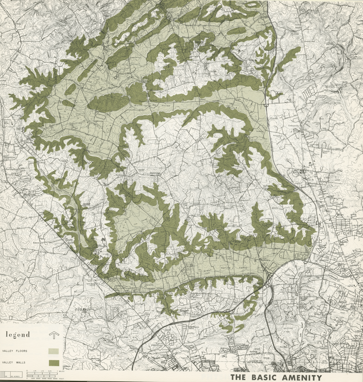
The basic amenity of the valleys: the valley floors and the forested walls. Source: The Plan for the Valleys (1964). Credit: Ian L. McHarg Papers, The Architectural Archives, University of Pennsylvania.
Physiographic Determinism
McHarg later recounted how “the concept of ecological determinism was invoked” to arrive at the optimal location for preservation and for development in the Valleys. 50 The PFV relied more specifically on physiographic determinism, which included factors such as geology, hydrology, and soils. The PFV asserted that “each of these processes interacts with the other; each has implications for development.” 51 The geology of the area consisted of Wissahickon schist on the ridges and limestone on the valley floor, according to The Technical Report, and influenced the potential location of development. 52 The limestone formation, known as Cockeysville marble, contained a vast aquifer beneath the Valleys. This drinking water was not only vulnerable to failures of on-site septic tanks but also to potential sewer leaks if lines were ever extended. In addition, the nature of the soils—silt loams with high permeability—was unsuitable for widespread use of on-site septic systems. 53 These physiographic observations provided valid reasons why development should not occur on the valley floors.
Two key related themes become evident early in The PFV process. First, the openness of the viewshed throughout the Valleys meant that complete protection of the valley floors was a necessity: “a small development of any kind will be extraordinarily conspicuous and can effect a major transformation and destruction” 54 (see Figure 4). Second, the R-40 one-acre zoning in the Valleys made the area vulnerable to the extension of sewers: “Should the Valleys be sewered, they will succumb to development and be erased forever.” 55 The PFV also postulated that sewer leakage could be as high as 20 percent and would pose a serious threat to the groundwater resources. 56
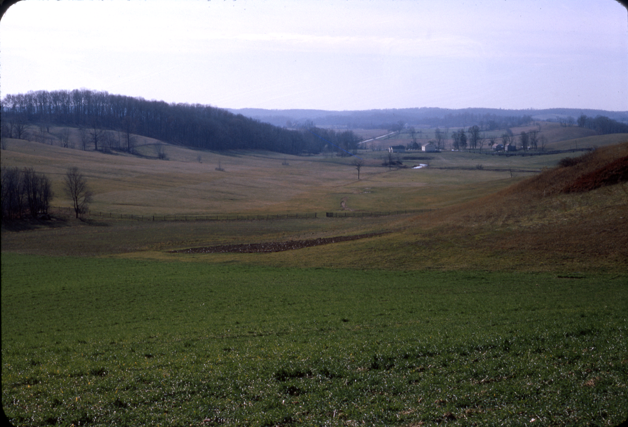
The Worthington Valley. Source: The Plan for the Valleys (1964). Credit: Ian L. McHarg Papers, The Architectural Archives, University of Pennsylvania.
The Specter of Uncontrollable Growth
The PFV projected that the population of the greater Baltimore region would double between 1964 and 1980, while the Baltimore County population was expected to rise from 500,000 to 800,000. 57 The Valleys region was projected to grow more than fourfold to 73,000 by 1980 and to a range between 110,000 and 150,000 residents by 2000. 58 If the higher level were reached by the end of the twentieth century, no open land would remain in the Valleys. 59 These population numbers did not assume imminent sewer extension, yet anticipated the development of up to 10 percent of the Valleys in the next few years. 60 The study explained that this alarming growth would result from the increased accessibility of the valleys as well as the pull of its natural beauty. The latter factor is, of course, one of the many contradictory dynamics of sprawl: people who move to an area for its rural character are also destroying that very quality.
The PFV defined “uncontrollable growth” as the “sequence or larger pattern, without any comprehensive plan or process for creating coherent communities with adequate open space.” 61 Wallace wrote that The PFV’s projected population and development forecast “literally scared the hell out of everyone.” 62 Future development would occur “over a considerably larger area than it would actually need to encompass in order to satisfy housing demand.” 63 This dire scenario became the driving force for The PFV to direct development and density to the plateaus above the valleys and in compact settlements.
Little residential development would occur in the valleys, and areas prohibited from development included fifty-year flood plains, land within 200 feet of stream edges, and steep slopes over 25 percent. 64 The PFV proposed a maximum density along the forested valley walls of one house per three acres, with all trees over a four-inch caliper subject to a preservation evaluation. 65 Similarly, density on forested plateaus would be limited to one house per acre, with the concentration of density reserved for the open plateaus. Here, gross density would average 0.6 dwelling units per acre, with open space alongside cluster pods of 4–29 dwelling units per acre served by central sewers. 66 Sewer service would also be needed for the tower apartments of up to 100 units per acre located on promontory sites overlooking the valleys. 67
The tower apartments reflected the design of Le Corbusier’s Towers in the Park, which was the model for many then-on-going urban renewal projects across the nation. 68 Wallace, who was primarily responsible for designing the development on the plateaus, drew on his architecture and urban renewal experience in calling for the tower apartments—apparently without considering whether such intense development was appropriate in a rural area.
The PFV also envisaged a connected network of hamlets, villages, and towns, ranging in population from 500 to 20,000 residents, with the larger settlements suggesting the influence of the garden city and new town movements. The variety of housing types and densities in these settlements was a very important part of The PFV and in particular embodied David Wallace’s social concerns. The PFV considered affordable housing a “vital” issue and emphasized that the “Valleys should not and cannot be reserved for upper income housing” as the result of planned growth. 69
An admirable goal of The PFV was its willingness to accommodate the projected growth of 110,000–150,000 new residents, while also arguing for a downzoning to one house per twenty-five acres in the Worthington Valley (see Figure 5). 70 Yet, in hindsight, one has to wonder how realistic such a regional plan was. How quickly would the population increase? And could the extension of central sewers to support such substantial development actually be kept out of the valley floors?
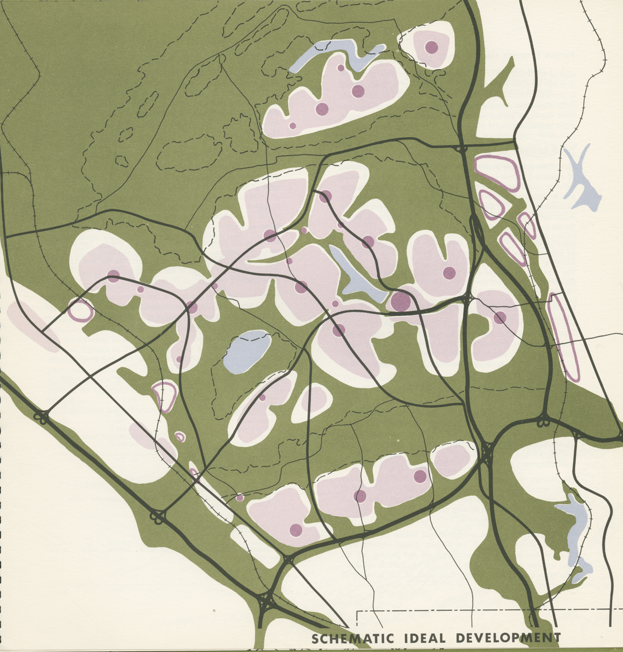
The ideal development pattern for the Valleys, mixing settlements with preserved valley floors. The developed areas are in gray and the valley floors in white. Source: The Plan for the Valleys (1964). Credit: Ian L. McHarg Papers, The Architectural Archives, University of Pennsylvania.
The action program of The PFV recommended three interrelated techniques to protect the valley floors: a phased urban growth boundary to limit the extension of sewer and waterlines, natural resource zoning to allow only low-density development, and a special conservation district for the purchase of conservation easements to keep the land undeveloped indefinitely. 71 These three techniques are found today in some of the nation’s leading counties in growth management, including Lancaster County, Pennsylvania; Lexington-Fayette County, Kentucky; and Sonoma County, California. 72
The action program also called for Baltimore County to adopt The PFV’s regulations into its comprehensive plan, underscoring that The PFV was a private plan but relied on public implementation in the form of zoning and infrastructure investment. 73
The PFV proposed a novel private Real Estate Syndicate, or what today would be considered a transfer of development rights (TDR) program to pay landowners on the valley floors for protecting the viewshed of the residents on the plateaus. In theory, the Syndicate would act as a general partnership capitalized with debentures and stock, the latter of which could be exchanged for the relinquishment of development rights. The Syndicate embodied a simple notion: “Those whose land will be worth more because of the Plan, can share part of the additional gains with those who voluntarily give up their right to development.” 74 Yet, the Syndicate would prove too complex to put into operation.
The Syndicate would have limited development on the valley floors and walls and directed it to the ridges and plateaus through a pricing mechanism that would pay for itself. The Syndicate would attempt to use various means—fee simple purchase, conservation easements, life estate, and right of first refusal—to obtain the development rights to land on the valley floors. The residents in the new developments on the plateaus would need to purchase the monetized value of the preserved views of the valleys. But The PFV failed to specify the actual development rights, even though those rights were instrumental to the feasibility of the Syndicate and the TDR. 75 The PFV envisioned that 3,000 acres of land would be preserved for agricultural use and that an aggregate benefit of US$7 million would occur to the developers by virtue of adopting optimum growth over uncontrolled growth, which could then be used to purchase conservation easements from the farmland owners at US$2,300 per acre. 76 This expectation was quite important for convincing the community to support The PFV.
Interestingly, in the early 1960s, the TDR had not yet been used anywhere in the United States. So, no one had a clear idea of how it should work. In 1978, Calvert County, Maryland, became the first county in Maryland and one of the first in the nation to create a TDR program. 77 The private sector does not create a TDR program, a local government does: an obvious flaw in the concept of the Syndicate.
The Path to Partial Implementation
In 1965, the Baltimore County Office of Planning and Zoning tacitly endorsed The PFV. 78 By 1969, Baltimore County had “more or less” integrated The PFV into its comprehensive plan, Guideline. 79 But the tower apartments, new towns, and residential pods on the plateaus were never built. Baltimore County did not change its zoning ordinance to enable large-scale development of the plateaus to happen. Instead, the county did eliminate several proposed school sites and sewer lines as a result of The PFV. 80 Without that public infrastructure, private investment would not follow. In short, the development elements of The PFV were shelved while the landscape protection aspects of the Plan came to the fore.
The PFV has three major landscape protection legacies that endure today, even though the Syndicate as a means of transferring development rights was never put into practice. First, in 1967, Baltimore County adopted an urban growth boundary, known as the URDL. The URDL has been expanded slightly on only one occasion since then. 81 The purpose of the URDL is to set a limit on the extension of sewer and waterlines. Lands with higher-density zoning inside the URDL have received central water and sewer services. Yet, sewer service has never reached the three valleys, which are located outside of the URDL (see Figure 1).
Second, Baltimore County instituted low-density RC Zoning beginning in 1976. Concerns about water quality in the County’s reservoirs began to galvanize citizens’ groups, the VPC, and the County Planning Commission to advocate for downzoning in the countryside. Despite The PFV’s call for downzoning in the Worthington Valley, zoning in rural Baltimore County had remained at a maximum density of one house per acre. Residential development could still easily leapfrog over the URDL and into the countryside, and the use of septic systems continued to spur rural residential development and the conversion of farmland and forests. 82
In response, the Maryland Department of Health recommended downzoning to one house per three acres to minimize possible groundwater contamination from on-site septic systems. 83 This action validated the power of the URDL in keeping sewers from rural areas as well as McHarg’s concerns about unsuitable septic locations in the valleys.
The county planning staff then demonstrated that the pattern of scattered rural residential development was threatening the county’s agriculture industry.
84
The county planning staff organized the North County Advisory Group, which was comprised of a wide array of stakeholders in the region. Their ensuing proposed land use regulations relied on five RC zones: I. RC 1—Flood plains, II. RC 2—Agricultural, III. RC 3—Deferred planning zone, IV. RC 4—Watershed, and V. RC 5—Rural residential.
RC-2 areas were based on prime soils, the absence of subdivisions, and a critical mass of farmland including farm size and farming intensity. County planners employed a sliding density scale that conferred one development right on parcels up to twenty acres, with another right for each additional twenty acres. RC-3 applied to the outside edge of the URDL and allowed a relatively low density of 0.3 houses per acre but with clustering on one-acre lots. RC-4 allowed one house per three acres and served as an overlay zone for all streams and reservoirs and included a prohibition on building steep slopes over 25 percent, echoing a recommendation of The PFV. RC-5 was proposed for development next to existing subdivisions and villages, with a two-acre minimum lot size.
The extensive RC rezoning became part of the new county zoning maps in 1976. Then, a new county executive requested a reassessment of active farms, which resulted in a change in the RC-2 zone in 1979, so that any farm up to 100 acres could be subdivided once for a 2-acre building lot, with another 2-acre building lot for each additional 50 acres. Although natural resource zoning discouraged widespread rural residential sprawl, it was not sufficient to halt a significant amount of rural residential development. 85
Third, in 1979, Baltimore County created a purchase of conservation easements program to preserve agricultural land from development. 86 Landowners in the three valleys and elsewhere outside the URDL have been able to preserve their land not only with the county but also through the Maryland Environmental Trust—a state-sponsored land trust founded in 1967 which accepts donations of conservation easements—and the Maryland Agricultural Land Preservation Foundation, the nation’s first state farmland preservation program, founded in 1977, which purchases conservation easements to farmland.
The Rural Legacy Program, created in 1997 as part of the state’s Smart Growth legislation, provides additional state funds to counties for the preservation of high-priority land. A county designates Rural Legacy Areas where landowners are eligible to sell conservation easements to the county to preserve their farmland and open space. The purpose of the Rural Legacy Areas is to preserve farmland and open space in large contiguous blocks. But none of the three valleys is located in a Rural Legacy Area (see Figure 1). Baltimore County designated rural legacy areas to the north of the valleys (see Figure 1), where the majority of the County’s farmland and preserved farmland is located. 87 Another reason is that the Green Spring Valley has experienced a considerable amount of rural residential development and is not a prime candidate for farmland preservation.
The central piece of the Smart Growth program is the Priority Funding Areas for directing state funding and desired growth. None of the three valleys is included in a Priority Funding Area because they are outside the Rural Urban Demarcation (see Figure 1). Rather, Baltimore County’s Priority Funding Area is the land inside the URDL where compact development is desired.
The PFV 50 Years Later
To what extent was The PFV vision implemented and how successfully? The PFV imagined that the Green Spring Valley’s slopes would have become more densely wooded, overhung by “silhouettes of apartment buildings on the ridges.” 88 Neither happened. The Green Spring Valley—the closest to the City of Baltimore and hence the most vulnerable—has lost its unique sense of place because of scattered residential development on large lots. But the Caves and Worthington Valleys have survived largely intact, in part because of the willingness of the farmland owners to sell or donate conservation easements on their land.
As of 2015, Baltimore County had preserved 62,828 acres of farmland toward a goal of 80,000 acres, primarily in the north and northwestern parts of the County. 89 The county ranks among the top ten counties nationally for acres of preserved farmland. 90
University of Maryland Professor Uri Avin has argued that although The PFV earned an American Planning Association National Planning Landmark Award in 2010, its reputation has been “obscured by legend,” for the plan itself was only partially implemented. 91 True, not one of the major development elements, such as the hamlets, villages, or tower apartments, was built. No real estate Syndicate was created to enable the TDR, in part because the public sector was needed to create a TDR program, and Baltimore County made no effort to create one. Although Baltimore County integrated much of The PFV into its comprehensive plan, the Valleys Planning Council had no control over zoning, and Baltimore County did not change the one-acre zoning to allow more intensive development, especially on the plateaus. As a result of all of these factors, The PFV’s vision of a large amount of population and development adjacent to the three valleys did not happen.
Over time, however, three land protection techniques recommended in The PFV came to fruition in the form of the URDL, the RC-2 agricultural zoning, and conservation easement acquisitions, which have formed a strong, interconnected set of land protection tools. McHarg proudly wrote in 1996 that the Valleys “more than 30 years later still retain their pastoral beauty.” 92
The URDL has succeeded in directing growth: today, 90 percent of Baltimore County’s 831,128 residents live within it, despite comprising only 33 percent of the county’s land area. 93 The URDL has also helped to delineate Priority Funding Areas in Baltimore County, to direct where the state should focus its infrastructure investments and promote compact development (see Figure 1).
The PFV’s proposal to provide central sewers to the plateaus seems, in retrospect, naive and in conflict with the preservation of the valley floors. The presence of sewers is a signal to landowners that their land has a higher value because it can be developed more intensively. So, what safeguards could The PFV provide that the sewers would never extend to the valley floors? The Plan’s land preservation recommendations relied on landowners on the valley floors voluntarily selling conservation easements. And even the recommendation for downzoning required a political decision by Baltimore County elected officials that could easily be reversed. Residents may have sensed that a TDR program (the Syndicate) would facilitate development of the plateaus and the necessary sewer extensions that over time could expand to enable unwanted development on the valley floors. Instead, the landowners consented to the sale or donation of conservation easements to preserve land and to downzoning to limit development potential. The inducement to sell or donate conservation easements would likely have been significantly lower if the countryside had become sprinkled with hamlets, villages, and tower apartments. As The PFV noted, “To many of the resident owners of undeveloped land, the character of the land represents a way of life.” 94
The implementation of RC Zoning in Baltimore County was a contentious process, yet has produced impressive results. RC zoning, a core recommendation of The PFV, has protected a large majority of the County’s watershed (92 percent), which provides drinking water to 1.8 million residents in the region. 95 The R-2 RC Zoning also protects more than 135,000 acres of agricultural land. 96
An important part of The PFV was the recognition of the need for affordable housing rather than wealthy suburban enclaves. But the success of land preservation in Baltimore County and the absence of the large development projects in the three valleys may have had a negative impact on housing affordability. The median cost of housing as a percentage of household income for Baltimore County is high. Nearly one third of homeowners with a mortgage spent 30 percent or more of their incomes on housing and 51 percent of renters paid 30 percent or more of their income on rent in 2014. 97 Yet, these housing burden figures are similar for the United States as a whole where 34 percent of homeowners with a mortgage paid 30 percent or more of their income on housing in 2014 and renters spent 52 percent of their income on housing. 98 In the three Valleys, for which discrete data are not available, there is ample anecdotal evidence that housing affordability is more out of reach than in the rest of Baltimore County. Also, between 2000 and 2010, the population of Baltimore County residing outside the URDL actually declined, suggesting high housing costs outside the URDL. 99 Arguably, if a large amount of housing had been built on the plateaus, the price of housing in Baltimore County might not be as high, and there would be less economic segregation in the county’s housing market.
Conclusion
The PFV remains a landmark in the history of managing growth in the United States in its attempt to balance large-scale development with landscape-scale land protection. With few models of sensitive greenfield development to draw on, Wallace–McHarg Associates proposed developments that combined elements of Le Corbusier’s towers in the park along with residential pods, garden cities, and new towns. Yet, the proposed developments were mostly simply out of scale with the largely rural surroundings and were never built. And since The PFV, the blending of large-scale development and landscape-scale land protection has proved elusive. Rather, separating development and protected land became an accepted strategy not only in Baltimore County but also in the nation’s leading counties in growth management.
Ian McHarg’s ecological determinism created a template for a natural resources inventory followed by an environmental suitability analysis for locating or discouraging development. In addition, the land protection techniques of urban growth boundaries, natural resource zoning, and the acquisition of conservation easements that emerged from The PFV are now crucial ingredients in the nation’s leading counties in growth management. 100
The PFV clearly played a role in the orientation of regional planning in Baltimore County. As Theresa Moore, a former executive director of the VPC, wrote, the Plan “galvanized the residents of northwestern Baltimore County, gained the respect of county agencies and elected officials, and laid a foundation for moving in the direction of smart growth.” 101
The VPC’s commissioning of The PFV was an unprecedented initiative but would be very difficult to emulate today both in terms of cost and the likelihood of implementation, coming from a privately funded study.
Ian McHarg earned the lion’s share of the credit for The PFV. And each year, the VPC gives an award in McHarg’s name in appreciation for his work. By contrast, David Wallace acknowledged that The PFV had not been fully implemented and commented rather bitterly that, “The failure in implementation was irrelevant to him [McHarg].” 102 Wallace remained disappointed in The PFV: “Unfortunately the Valleys cannot be considered, as has been touted, to be the first successful large-scale example of humane development and conservation of the countryside by citizen action.” 103 Yet, he conceded that the landowners were nevertheless pleased by the end result, even though many had not supported the development proposals in the plan.
Footnotes
Declaration of Conflicting Interests
The author(s) declared no potential conflicts of interest with respect to the research, authorship, and/or publication of this article.
Funding
The author(s) received no financial support for the research, authorship, and/or publication of this article.