
Abstract
Recent scholarship provides evidence for reconsidering the original urban plan for Washington, DC, one of the world’s few planned cities. Commissioned by President George Washington in 1791, Pierre L’Enfant did not, as some scholarship claims, simply follow baroque urban design concepts with associated geometric patterns for his design. Rather, the character of the land guided the location of public squares, each for a state with a “reciprocity of sight” along communicating avenues. L’Enfant conceived of these individual but visually linked state districts as a metaphor that demonstrated a new nation’s ideals of independence and unity in built form.
Keywords
In the years following the American War of Independence, it became clear that federal government operations needed a permanent location. Rather than chose an existing city, the Congress of the Confederation decided that a new city, centrally located, would be desirable and President George Washington chose Pierre Charles L’Enfant as the most qualified person in America to design it. This article briefly examines several circumstances that affected L’Enfant’s work: the path taken to select the new city’s location and the topographic character that recommended it, L’Enfant’s qualifications and experience, and the administrative framework, including the appointment of three commissioners to oversee his work, which hampered its execution. The chosen site and L’Enfant’s design is then examined in detail including how the plan was shaped by the land and water, as well as other influences. The author relies on original letters and L’Enfant’s reports that reveal his progress culminating in an original and brilliant urban design that was a metaphor representing the new nation’s ideals in built form. The author has drawn L’Enfant’s proposed design on recently reconstructed 1791 topography to show the implications of his strategy to develop and populate the new city. The article concludes with comment on why L’Enfant’s plan was only partly realized, what was built instead, and why his work remains of interest.
Locating a Permanent Seat of the Federal Government
Between 1783 and 1791, there was much debate by the country’s leaders about balancing the role and responsibilities of the federal government with state sovereignty, and this affected the location and design of a federal city as the capital of the new nation. By 1785, Congress had moved ten times and met in eight different locations in four states, some barely towns with inadequate housing and assembly accommodations for visiting politicians. Every move disrupted proceedings and made retaining documents more difficult. Other events reinforced the need for a permanent place for the government. For example, on June 21, 1783, Congress fled Philadelphia to Princeton, New Jersey, because some 250 irate soldiers descended on the State House to demand back pay from the Pennsylvania Executive Council who were also meeting in the same building. 1
Later that year, on October 7, 1783, Congress approved a site along the Delaware River for the federal city but retracted their approval ten days later, and the subject was not discussed again for another two years. L’Enfant, a French engineer and architect with an office in New York City, anticipated an urban design commission in that location and wrote to Marquis de Lafayette on November 2, 1785, saying he had surveyed land along the Delaware River and was preparing plans for a federal city. 2
The need for a permanent seat, although not the specific location, was established when James Madison supplied the following definition in a section of the US Constitution presented for approval in September 1787: To exercise exclusive Legislation in all Cases whatsoever, over such District (not exceeding ten Miles square) as may, by Cession of particular States, and the Acceptance of Congress, become the Seat of the Government of the United States, and to exercise like Authority over all Places purchased by the Consent of the Legislature of the State in which the Same shall be, for the Erection of Forts, Magazines, Arsenals, dock-Yards, and other needful Buildings.
3
The deadlock was finally settled at a dinner in the middle of June 1790 in Manhattan. Thomas Jefferson, then Secretary of State, Alexander Hamilton, then Secretary of the Treasury, and congressmen Richard Bland Lee and Alexander White, both of Virginia, agreed on a location in what is known as the Compromise of 1790. It stipulated that the federal government would move from New York City to Philadelphia for the next ten years and would assume the 20,000,000-dollar war debt for all states in exchange for locating the national capital on the Potomac River between the states of Virginia and Maryland. 7 While this compromise was a great financial disadvantage to Virginia and other southern states, except South Carolina, who had discharged their war debt and paid their soldiers, the advantage was the permanent location of the federal government adjacent to their state.
L’Enfant as Urban Designer
From the ages of four until twelve, L’Enfant lived at Versailles where his father worked for the king and where he was exposed to the gardens designed by Andre Le Nôtre. 8 Later, from 1771, L’Enfant spent six years at the Royal Academy of Painting and Sculpture in Paris. 9 In April 1777, at the age of twenty-three years, L’Enfant left France to serve in the Continental Army. At Valley Forge, L’Enfant had direct contact with General Washington and other officers and his artistic talents were put to various uses. Marquis de Lafayette had him draw the portrait of Washington (unfortunately lost) as well as other officers. Inspector General Baron Friedrich von Steuben, training raw recruits at Valley Forge, had L’Enfant illustrate his manual, “Regulations for the Order and Discipline for the Troops of the United States.” 10 L’Enfant was made a captain in 1778, and hoping to engage with the enemy more directly, went south. He was wounded in the Siege of Savannah on October 9, 1779, and it took several months for him to recuperate. He was taken prisoner by British forces in the surrender of Charleston on May 12, 1780 and exchanged with other officers in November. L’Enfant was promoted to the rank of brevet major in the Corps of Engineers five months before the war ended (September 3, 1783) and was honorably discharged on January 1, 1784.
Living in New York City, the current seat of the federal government, L’Enfant continued to serve national interests. 11 Washington commissioned L’Enfant to design the certificate and bronze medal for the new Society of the Cincinnati, which required him to return to France for its casting in December 1783. Jusserand notes in a letter from L’Enfant to General Rochambeau dated June 15, 1786, that the fee he expected as compensation for his design was slow to arrive. 12 This is an early example of the “gentleman’s agreement”-type contract where L’Enfant was asked and agreed to work without stipulating his fee, and when the execution cost exceeded expectations, his work was unfairly compensated.
Another example of L’Enfant’s business challenges arose with a project to renovate New York’s old City Hall (built 1699–1703) into a new Federal Hall in 1788. Occupying British forces had used the building as a prison during the war and Congress had meet there from 1785 until the move to Philadelphia in December 1790 for the third session of the first Congress. The renovation was an important project because the first Congress under the constitution was to meet there on March 4, 1789, and Washington’s inauguration was to take place there two months later on April 30. Working as one of five appointed commissioners—the traditional English system to oversee large civic projects—L’Enfant’s role according to Scott was “to purchase the Materials & superintened (sic) the said Business…” 13 L’Enfant had to cooperate with others who were likely to be less educated in the design fields and less experienced with construction. Some thought the result was the most beautiful building in America, but it was shoddily built and lasted only twenty-three years before being demolished. 14 The offer for L’Enfant’s compensation for this work was honor and ten acres of Manhattan land, which he declined, and a few years later, US$750, which he also declined. 15 L’Enfant’s architectural office completed at least fourteen other residential and commercial projects around New York in the six years leading up to the design commission for the new capital city. 16
L’Enfant had been seeking the Capital commission for years. He reminded Washington of his interest in a letter dated September 11, 1789, offering to design “the capital of this vast empire,”
17
but the formal appointment would take another sixteen months. After the compromise of 1790, Washington obtained congressional approval for the “Act for Establishing the Temporary and Permanent Seat of the Government,” or more simply, the “Residence Act,” which the First Federal Congress passed on July 12, 1790, and Washington signed on July 16. The Act stipulated three requirements: The site would be no more than ten miles square (ten miles by ten miles). The site would be located along an eighty-mile stretch of the Potomac River between the Eastern Branch (now the Anacostia River) and Connocochegue Creek (now the town of Williamsport) about twenty miles south of the Pennsylvania state line. Three commissioners would oversee the purchase of land and construction of the “buildings for Congress, the President’s House and public offices by the first Monday in December 1800.”
18
Eight months later, the Act was amended on March 3, 1791 (a day before the first session of Congress ended), to require “the whole of the district of territory” to include the port of Alexandria in Virginia to the mouth of Hunting Creek, which is just south of the city as well as the land south of the Eastern Branch. However, there was a stipulation “That nothing herein contained, shall authorize the erection of the public buildings otherwise than on the Maryland side of the river Potomac.” 19 This amendment insured the final location had to be the southernmost portion of the eighty-mile river stretch and that all federal buildings be built on the Maryland side of the river. A later consequence of this change was that Congress retroceded thirty-one square miles on the west side of the Potomac River back to the state of Virginia in 1846, partly because the amendment hurt the economic development of northern Virginia and partly because the city of Washington was moving toward abolishing slavery.
Meanwhile, on or about January 22, 1791, Washington appointed the three commissioners. Representative Daniel Carroll of Rock Creek (Montgomery County), Maryland, sixty-one years old at that time, was a cousin of Charles Carroll, one of the wealthiest men in Maryland. Daniel Carroll’s brother-in-law was Notley Young and his nephew was Daniel Carroll of Duddington, both of whom owned large tracks of land in the chosen location. Thomas Johnson of Frederick County, Maryland, fifty-nine years old at that time, was a judge and the first governor of Maryland (1777–1779) and later became president of the Potomack Company (described later in this article) after George Washington. Dr. David Stuart of Abingdon Plantation near Alexandria, Virginia, thirty-eight years old at that time, was Washington’s private physician and husband to the widow of Mrs. Washington’s son. These gentlemen may seem unqualified in today’s terms to oversee a large civic project, but they were wealthy, which was helpful considering they were unpaid during their first two years of service, they were land owners, familiar with the location as well as other proprietors, and committed to the formation of a new government. This also meant they had personal interests to consider in their decisions. Lewis observes, “He [Washington] chose friends who possessed no qualifications for the task.” 20 As Commissioners charged with overseeing the project, and hence L’Enfant, both their lack of design experience and the financial situation of the federal government caused difficulties for L’Enfant and the execution of his urban design.
Aspects of the Site’s Landscape
The final site was located at the confluence of the Potomac River and the Eastern Branch, 3 miles from the head of tidewater and 200 miles inland from the Chesapeake Bay off the Atlantic Ocean. It was a place with many qualities to recommend it. For the past 150 years, Indian tribes lived along these rivers benefiting from the temperate climate, abundant fish and game, and rich, fertile soil. Tidewater Potomac had ninety-eight navigable bays or creeks equally supplied from Virginia and Maryland. Further, the Potomac River flowed east from the Allegany Mountains, part of the Appalachian Mountain range from which the Ohio River flowed west into the Mississippi River. Lawrence Washington, George Washington’s older half-brother, formed the Ohio Company to promote commercial passage from Virginia to the west. 21 George Washington founded and was president of the Potomack Company since its inception in March 1785, whose purpose was to connect the Potomac via a canal to the forty-mile-long wagon road to the Monongahela, which is a navigable fork of the Ohio River. 22 Once the connection was finished, it would greatly improve trade with the west, especially with the three territories of Kentucky, Tennessee, and Ohio. It would also make George Town and Alexandria rival British-held Montreal and Spanish-held New Orleans as ports of international trade. Undoubtedly, this inner-coastal passage was considered to be of great advantage to the future prosperity of the country and further recommended this specific location for the federal city.
Other aspects of the location were described by Tobias Lear, Washington’s personal secretary, who published Observations on the River Potomack, the Country Adjacent, and the City of Washington in 1793, which Scott described as “a factual account that focused on what businessmen and developers would need to know about local conditions and services.” 23 In the pamphlet, Lear noted, “The number of inhabitants living in the several counties of Virginia and Maryland, bordering upon the Potomack or its branches, amount to upwards of three hundred thousand, according to the census taken by order of the general government, in the year 1791.” 24 More locally, 4,900 people lived in George Town in 1793, mostly engaged in the inspection and export of tobacco to Europe. 25 The port of Alexandria also exported tobacco, as well as flour and wheat. In sum, the location on the Potomac and its surrounding population and the presence of two active ports were great attributes of this location, but its significant advantage was its centrality, which was an essential priority for President Washington, as Jusserand notes, “constantly mentions in his letters.” 26 The site was nearly the geographic center of the country between Georgia and New Hampshire and close to the center of the country’s population, which was actually a point considerably north of Virginia, even if slaves counted, although future growth was expected to be in the south and toward the west. 27 Washington, Jefferson, and Madison—all Virginians—also favored the site because it was close to home and, according to Gutheim, “they feared that westerners might seek independence (or connections with other nations) if frustrated by an inappropriate location of the new capital or by other decisions against their interests.” 28
To further entice Congress to select this site, Maryland offered 5,000 acres and $72,000, and Virginia offered 3,000 acres and $120,000. This ceded 8,000 acres of land was a small but central portion of the projected 64,000 acres that is ten miles square. These gifts and the proceeds from future city lot sales allowed the construction of the federal buildings to proceed until 1796 without the need to ask Congress for additional funds. 29
The center part of the site was between George Town and the Eastern Branch and made up of seventeen tracts of farmland mostly exhausted from growing tobacco, which also contained maize fields, woods, and orchards with a few cottages and graveyards. Within it were two plotted hamlets with a few buildings. Hamburgh was on the Potomac River between Rock Creek and Tiber Creek, and Carroll’sburgh (or Carrolsburg) was at the point of land between the Potomac River and the Eastern Branch.
On March 30, 1791, nineteen proprietors signed an agreement to convey their land to the federal government. 30 The terms allowed the proprietors to retain possession of every other plotted lot and to receive twenty-five pounds per acre for land taken for public use, which they could use and profit from until the lots were laid out. No compensation was given for the land needed for public streets and alleys. 31 In this manner, land was secured for the federal city at little or no cost. 32 Unfortunately, many property boundaries were not accurately recorded and the Commissioners spent months sorting claims while land speculators anxiously awaited the specific locations of major public buildings to be constructed first.
L’Enfant’s Design Approach
Officially appointed on January 29, 1791, L’Enfant arrived in George Town five weeks later on March 9. He found Major Andrew Ellicott, appointed by Washington in February, leading a team of surveyors to set the city boundaries. Ellicott had previously served in the Maryland militia as a surveyor and had worked on the disputed 244-mile border between Maryland and Pennsylvania with other parts along West Virginia (then Virginia) and Delaware from 1763 and 1767. This resolved as the Mason-Dixon Line, chiefly a nearly straight line, approximately along the fortieth parallel, which ignores the presence of terrain and waterways. This process of surveying follows administrative direction and not the topography because its intent was to document negotiated decisions and not to react to found conditions. For the city of Washington, the surveying work took a trained team and required specialized equipment to determine precise locations and distances. Benjamin Banneker, a local free black mathematician and amateur astronomer, assisted with the celestial observations to establish the cardinal directions and as the master of the complex surveying equipment. 33 Ellicott’s two younger brothers, Benjamin and Joseph, were also part of the team. L’Enfant’s assistants were Issac Roberdeau, another surveyor who later served as a Major with the Topographical Engineers until 1818, Stephen S. Hallet, a French-trained architect who immigrated to America at the outbreak of the French Revolution, and Charles de Krafft, another surveyor and draftsman.
Jefferson outlined L’Enfant’s instructions in a letter on about March 8 for “Laying out the hills, valleys, morasses and waters between that (Eastern branch) and the Potomac, Tyber [Tiber], and the road leading from George Town to the Eastern branch and connecting the whole with certain fixed points on the map Mr. Ellicott is preparing.” 34 Jefferson was keenly interested in the design of the new federal city. 35 The previous August and September, just one and two months after the Residence Act was approved, Jefferson sent Washington letters that included sketches of his ideas for the new city’s layout as a small grid with the federal buildings closely spaced. L’Enfant, now living in George Town, promptly examined the land on horseback and even with heavy rains and snow that continued for six days, likely followed higher ground to avoid the rain-soaked and muddy stream beds. The land was very different from the fairly flat French royal gardens L’Enfant knew. The rolling hills—Lear described the land as “wavy”—had many navigable streams that descended about forty feet from the surrounding escarpments onto the tidal flats of Tiber Creek from the north and Jenkins Hill rising about eighty feet above the Tiber’s high tide to the east. 36
L’Enfant recorded his preliminary impressions immediately in a letter to Jefferson, dated March 11, noting Washington’s approval of “a rough drawing in pencil of the several surveys which I had been able to run” and claiming his expanded role to produce “the delineation of a grand plan for the local distribution of the city.” 37 While Ellicott’s team was surveying the four 10-mile-long boundaries and setting forty permanent monuments or markers spaced one mile apart, L’Enfant’s team focused on the land between Rock Creek and the Eastern Branch, partly at the request of Jefferson who did not want them to focus on a small area and have land owners inflate their demands and partly because L’Enfant was considering a far bigger city than Jefferson envisioned. L’Enfant planned an urban design for a population of 800,000, which was the size of Paris at that time. 38 L’Enfant’s design progress through the spring and summer of 1791 can be traced following the three reports he made to Washington.
On March 26, 1791, only seventeen days after his arrival, L’Enfant presented an eight-page report to Washington—known as the First Report—in which he commented on two aspects of Jefferson’s design ideas. L’Enfant thought the hilly situation was not conductive to a grid-type plan and he did not want to concentrate the important public buildings in a central core. L’Enfant described his position in the report stating, In endeavoring to effect this (grand prospects and defensible high ground, a plan that can grow, efficient space between important buildings) it is not the regular assemblage of houses laid out in squares and forming streets all parallel and uniform that it is so necessary, for such a plan could only do on a level plain and where no surrounding object being interesting it becomes indifferent which way the opening of streets may be directed.
39
Thus, reassured by the President, L’Enfant immediately asked Jefferson for maps of London, Madrid, Paris, Amsterdam, Naples, Venice, Genoa, and Florence, which are all cities with seaports or dockyards and arsenals, suggesting L’Enfant was looking for information about how large cities managed their ports and their defense. Jefferson sent L’Enfant his maps of Paris and Amsterdam as requested, as well as maps of Frankfort, Karlsruhe, Strasburg, Orleans, Bordeaux, Lyons, Montpelier, Marseilles, Turin, and Milan. At that time, these were mostly walled medieval cities on rivers with narrow streets that had no dominate geometric order, and according to Reps, only “Karlsruhe showed the use of a symmetrical radial street pattern and it is doubtful if others provided much in the way of inspiration” for L’Enfant, a person already familiar with Versailles, Paris, other French cities, and likely other European city plans. 41
On June 12, Washington returned to Mt. Vernon. Historians are disappointed that Washington did not note his next meeting there with L’Enfant in detail, but it likely occurred on or after June 22 because L’Enfant’s next report—the Second Report—bears that date. 42 The accompanying drawing, which does not survive, was enough for L’Enfant to obtain Washington’s comments. Five days later, Washington went to George Town to meet for two days with land proprietors, Commissioners, and several subscribers to execute deeds and showed them L’Enfant’s drawing that located some principle points along with his report. The report mentions the advantages of building on higher ground, using the few existing roads as the proposed principle broad avenues, and turning Tiber Creek into a canal.
L’Enfant’s Third Report was presented to Washington on August 19 and reflected changes ordered by him. The report included a drawing L’Enfant referred to as the “annexed map of dotted lines,” which indicated the progress of the surveying work, and was, in L’Enfant’s words, “correct only as it respects the situation and distance of objects” 43 (Figure 1). This drawing has no title, author, date, or scale noted but has shaded rectangles for the National Church and Judiciary sites and locates the President’s House and Congress House at the center of nine and twelve radial avenues, respectively. 44 Miller makes a persuasive argument for the influence of the Baroque landscape plan of Chateau de Chanteloup, near Ambroise and Tours, which was probably known to L’Enfant because the printed map was done by the same person who installed his father’s paintings at Versailles and his son served with L’Enfant in the War for American Independence. In this hunting forest, Miller observes, “a rigid grid pattern of pathways was simultaneously integrated with radial tree-lined allées, creating a multiplicity of transparent uninterrupted views leading to ronds points, and artifices.” 45 L’Enfant’s proposed design also showed the significant changes in elevation, major waterways, other principle avenues, and eleven public squares, the importance of which is examined later in this article.
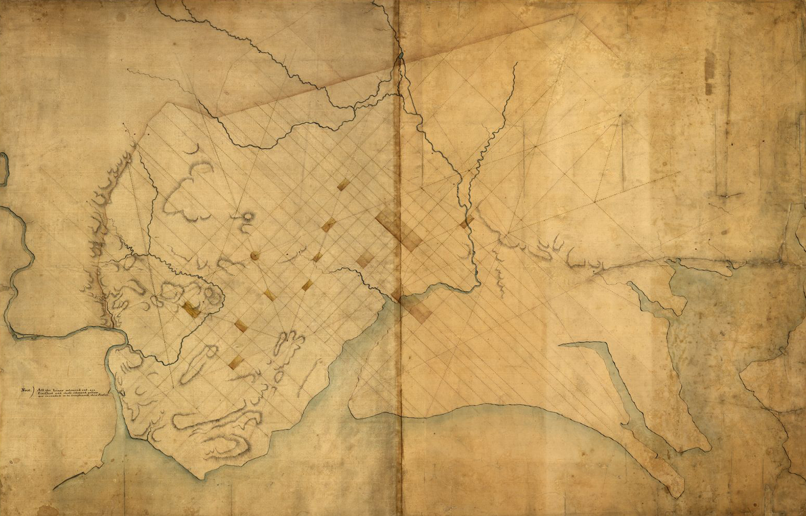
Dotted line map of Washington, DC. P. C. L’Enfant, 1791, Public domain image from the Geography and Map Division, US Library of Congress.
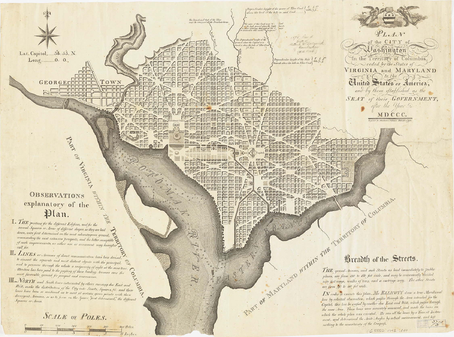
According to Reps, sometime later in August, L’Enfant presented his final revised design to Washington in Philadelphia 46 (Figure 2). The drawing showed L’Enfant’s full urban design and included descriptive notes about the avenues and streets, public buildings and spaces, public squares to be allotted to each state, as well as monuments, five grand fountains, the canal, and a Grand Cascade at the western foot of the Congress House. The intent was to have 10,000 copies printed in time for the first sale of lots scheduled for October 17. Jefferson’s letter about the engraving, dated the previous day, says that either L’Enfant or Mr. Ellicott has the right to have it printed, on which L’Enfant wrote in pencil, “What right could this man have thereto?” 47 This is significant because L’Enfant expected to earn royalties from the drawing sales. The report that accompanied the plan was sent to the Commissioners in George Town.
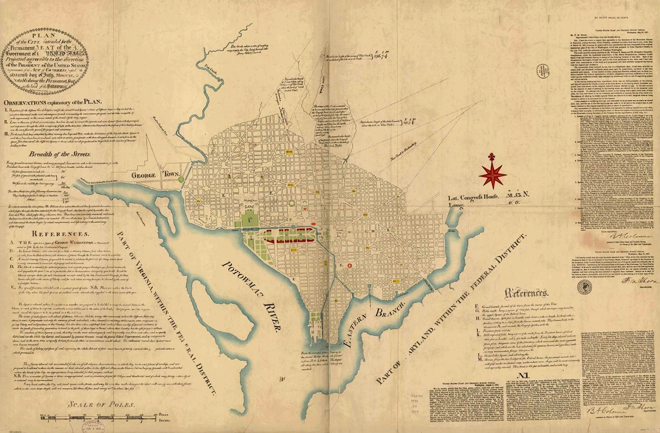
Plan of the city intended for the permanent seat of the government of the United States. P. C. L’Enfant, 1791, Facsimile by the US Coast and Geodetic Survey Office (1887). Public domain image from the Geography and Map Division, US Library of Congress.
Sometime between August 28 and 31, L’Enfant met with Jefferson and Madison in Philadelphia. On August 28, Jefferson wrote to the Commissioners asking for a meeting on September 7 or 8 to set the terms for the lot sale. L’Enfant did not want to rush the sale and insisted in his Third Report that the final drawing be made available to the whole continent simultaneously to avoid speculation and promote fair sales, which would provide more funds for construction. Nevertheless, on September 8, Jefferson and Madison met the Commissioners in George Town to finalize details and settle on the name as “The City of Washington, in the Territory of Columbia.” Additional decisions included using the alphabet and numbers for the street grid fill between the diagonal and radial avenues with the Congress House and its public grounds as the starting point, setting the maximum height of buildings as equal to the width of the principle streets, and requiring the buildings be constructed of fireproof materials stating “outer and party-walls of all houses within the said city shall be built of brick or stone.” 48 They also wanted the drawing to include depth soundings for the Eastern Branch to convince potential land buyers of its navigability, and this work had not yet been done. A few days later, on September 12, Ellicott asked L’Enfant to add the depths of the Eastern Branch to the drawing in time for the October lot sale. Less than two weeks later, on September 24, the Commissioners optimistically instructed L’Enfant to employ 150 laborers to commence construction on the two main public buildings, the President’s House and Congress House, which indicates their support of the design and confidence in its execution under L’Enfant’s direction. 49
L’Enfant’s Design
Between the professional surveyors’ work delineating the ten-mile square boundaries, waterways, and terrain topography, and L’Enfant’s discussions with Washington and Jefferson, who were both experienced amateur surveyors, L’Enfant’s design undoubtedly started with the lay of the land.
L’Enfant’s first task was to locate the President’s House and Congress House on higher ground with the best prospects and to defend their distance from each other and then to lay out areas for other governmental departments, public places, and sites for commercial and cultural activities. The Congress House 50 and President’s House 51 were connected by a Public Walk, similar to Jefferson’s proposal, which was lined with embassies, cultural buildings including playhouses (theaters), rooms of assembly, and academies. The judiciary branch of government, which was not yet formed by Congress, was to be close to these buildings but not directly connected, reflecting its status as an independent branch of government. L’Enfant’s design also located a national bank, nondenominational national church, and three markets. An historic column was placed exactly one mile east from the Congress House to mark the nation’s distance standard. An equestrian statue of President Washington was to be placed at the intersection between the Congress House’s east–west axis and the President’s House’s north–south axis. According to Bednar, these were all part of “the hallmark of the plan, a monumental federal precinct that takes advantage of its topographic setting and its river location through grand vistas.” 52
L’Enfant’s second concern was how to populate the city. Over a decade of debate between state’s rights and the federal government surely impressed upon L’Enfant the need to have the urban design provide for how representatives from each state, in addition to a supporting population, could live and work in the federal city. His proposal reflects a keen understanding of the need for public space of people who live in cities. L’Enfant’s last and most complete drawing included Observations Explanatory of the Plan (Explanatory Notes) that Scott calculates included “6,111 acres of which 54.6 percent was for public space with fifteen squares colored yellow.” 53 The size of the fifteen public squares—eight rectangles, four ovals, and one each of round, triangular, and square shapes—was based on the number of avenues that led to them. They were identified by number only and described in the Explanatory Notes as “to be divided among the several States of the Union, for each to improve with statues, columns, obelisks, or any other ornaments such as the different states may choose to erect.” L’Enfant further says that each state would be responsible for developing their district constructing residential and commercial buildings in a manner that represented their state, which “must leave to posterity a grand idea of [the] patriotic interest that promoted it.”
The locations of the public squares were not only based on the high points but also on the waterways. L’Enfant explained this in a letter to Hamilton saying, “The city must be beautiful, due advantage being taken of the hilly nature of the spot for grand or lovely prospects, and of its water resources for handsome fountains and cascades.” 54 L’Enfant’s survey located twenty-five springs that supplied fresh water in all seasons, creeks, and navigable streams that ran through the city. 55 Each state’s public square was located on higher land near a source of fresh water, which was an essential requirement for any dense development at that time. The waterways would also provide transportation and a means to flush waste away.
Understanding that vistas connect distant places, L’Enfant spaced the public squares about one-half mile apart, which is about as far as the eye can distinguish building-scale objects. Thus, the “reciprocity of sight” between squares would be a means to connect one state to another. Such visual proximity would also have the benefit of making places seem closer, which was the way L’Enfant addressed a criticism of his design that had greater distances between principle buildings than others thought desirable. Wide avenues connected the open public spaces thereby linking the states and uniting the city. L’Enfant intent, outlined in his Explanatory Notes, proposed that states would rapidly develop their individual districts by constructing the more important buildings around their public centers and spreading outward from there. What was built would reflect local pride and the customs of the state, and healthy competition between states would promote more investment in design and accommodations.
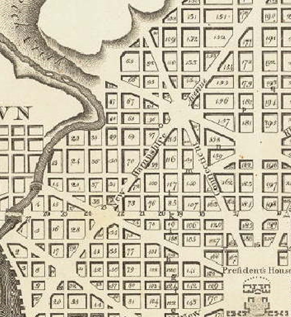
L’Enfant’s drawing did not identify block numbers or which of the numbered public squares colored yellow were to be assigned to a particular state, nor were the names of the avenues noted. The avenue names were likely decided at the meeting between Jefferson and Madison at the end of August in Philadelphia as preparations for the first official printing were underway. 56 The names first appeared in print on Samuel Hill’s engraving of Ellicott’s plan published in the May 1792 issue of Massachusetts Magazine (under circumstances described later in this article). While letters from that time do not record how these decisions were made, in general, the avenues named for the northern states were located in the northern part of the city, southern states in the southern portion, and the middle states in the central portion. The prominence of Pennsylvania, the current seat of the federal government, undoubtedly made the undisputed claim for the primary avenue connecting the President’s House and Congress House, which is in the approximate location of an existing dirt road that went from a ford across Rock Creek to George Town and to the ferry (soon drawbridge) over the Eastern Branch. 57 Two other existing roads were turned into Maryland Avenue, which led to Bladensburg, a town ten miles inland to the east and the last place ocean-going vessels could navigate off the Eastern Branch, and Massachusetts Avenue, which led to Frederick-Town to the northwest, “one of the largest inland towns in the United States,” as noted by Lear in 1793. 58
While all the avenues, except Georgia Avenue, retain their names to this day, no attempt has been made (to my knowledge) to identify which public square and surrounding district was intended for each state. Perhaps L’Enfant thought Washington would be the right person to award a state a specific area of the city. Nevertheless, by a process of elimination, the allocation of numbered public squares to a specific state can be determined, given that each state had only one public square and it was certainly meant to be located along its named avenue (Figure 3). Thus, the location of each state’s public square can be identified, the approximate district size and extent can be estimated (outlined by the author in thick lines on Figure 3), and the intended built metaphor of a united city, corresponding to a united states, can be imagined.
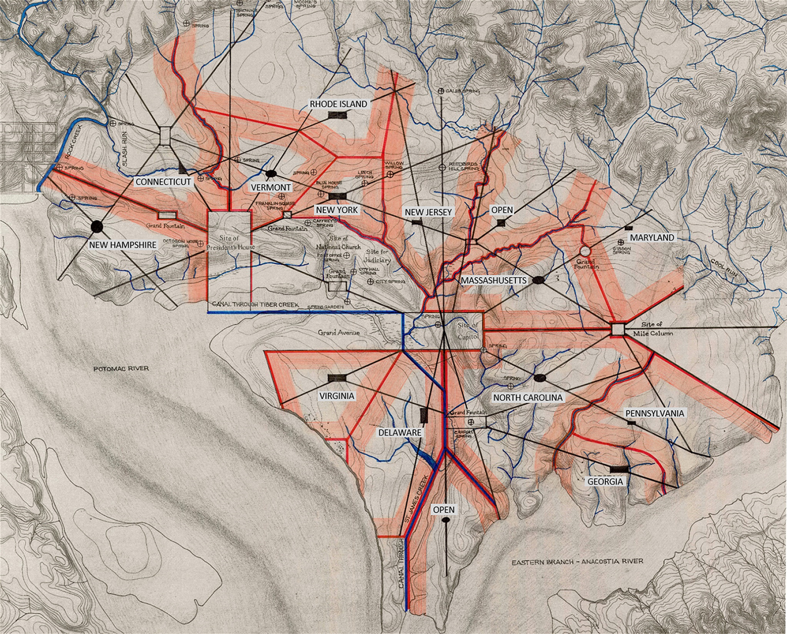
Topography of the federal city, 1791, with L’Enfant’s plan overlaid. D. Hawkins, 1990, Public domain image from the Geography and Map Division, US Library of Congress. Overdrawn by the author to show state’s districts.
The State Districts
Based on this interpretation, an analysis of the findings overdrawn on Hawkins’ 1791 topographic map suggests the following characteristics for each state’s district (working clockwise from west and with named springs identified):
The district of New Hampshire Waterways—Rock Creek and Potomac River with numerous tributaries. Existing infrastructure—the ford over Rock Creek leading to George Town. Context—adjacent to George Town to the west and the President’s House to the east. Access to fresh water—has two existing springs (Octagon House Spring) and a proposed Grand Fountain. Elevation—the public square—a circle—is located about seventy feet above the river, about fifteen feet above the elevation of the President’s House, and on the highest elevation within the area. Prospect—the favorable views are west and south toward the Potomac River and Virginia.
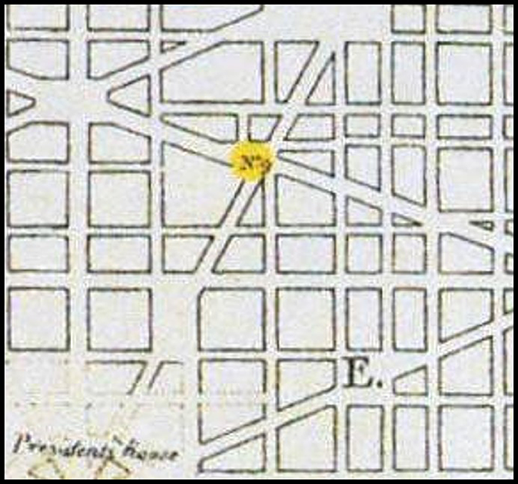
The district of Connecticut (Figures 4
–6) Waterways—Rock Creek and Slash Run. Existing infrastructure—the ford over Rock Creek leading to George Town and an existing road to Frederick-Town, Maryland. Context—adjacent to George Town to the west, the escarpment to the north, and the President’s House to the southeast. Access to fresh water—has three existing springs and a proposed Grand Fountain. Elevation—the public square—a triangle—is located on the bank of Slash Run, near but not in an intersection of three avenues (now Dupont Circle). Prospect—the most favorable view would be toward the President’s House.
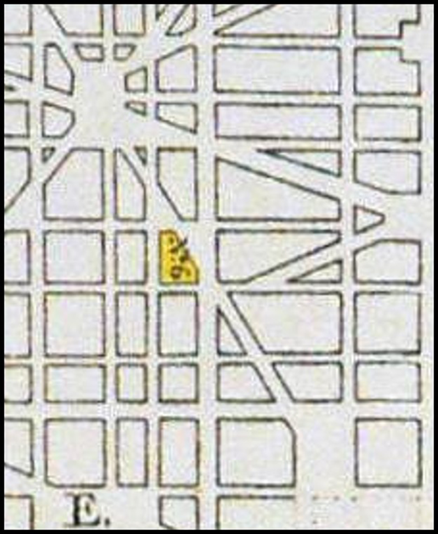
Detail of L’Enfant District of Connecticut’s Public Square—No. 6. Plan of the city intended for the permanent seat of the government of the United States. P. C. L’Enfant, 1791, Facsimile by the US Coast and Geodetic Survey Office (1887). Public domain image from the Geography and Map Division, US Library of Congress.
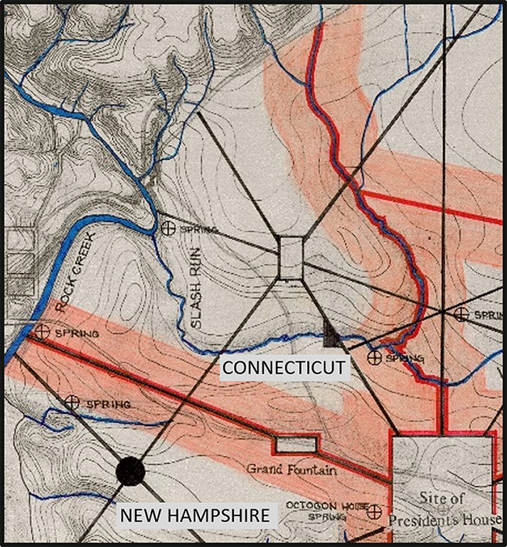
Detail of the District of Connecticut. Topography of the federal city, 1791, with L’Enfant’s plan overdrawn by author. D. Hawkins, 1990, Public domain image from the Geography and Map Division, US Library of Congress.
Detail of the plan of the city of Washington. A. Ellicott, Printed by Thackara & Vallance, Philadelphia (1792). Public domain image from the Geography and Map Division, US Library of Congress.
The district of Vermont (Figures 7
–9) Waterways—a tributary of Slash Run. Context—adjacent to the President’s House to the south. Access to fresh water—has three existing springs (Franklin Square Spring) and a proposed Grand Fountain. Elevation—the public square—an oval—is located about twenty-five feet above the elevation of the President’s House and close to the highest elevation within the area. Prospect—the most favorable views would be toward the President’s House and toward the district of New York’s public square.
Detail of L’Enfant District of Vermont. Plan of the city intended for the permanent seat of the government of the United States. P. C. L’Enfant, 1791, Facsimile by the US Coast and Geodetic Survey Office (1887). Public domain image from the Geography and Map Division, US Library of Congress.
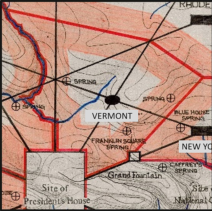
Detail of the District of Vermont. Topography of the federal city, 1791, with L’Enfant’s plan overdrawn by author. D. Hawkins, 1990, Public domain image from the Geography and Map Division, US Library of Congress.
Detail of the plan of the city of Washington. A. Ellicott, Printed by Thackara & Vallance, Philadelphia (1792). Public domain image from the Geography and Map Division, US Library of Congress.
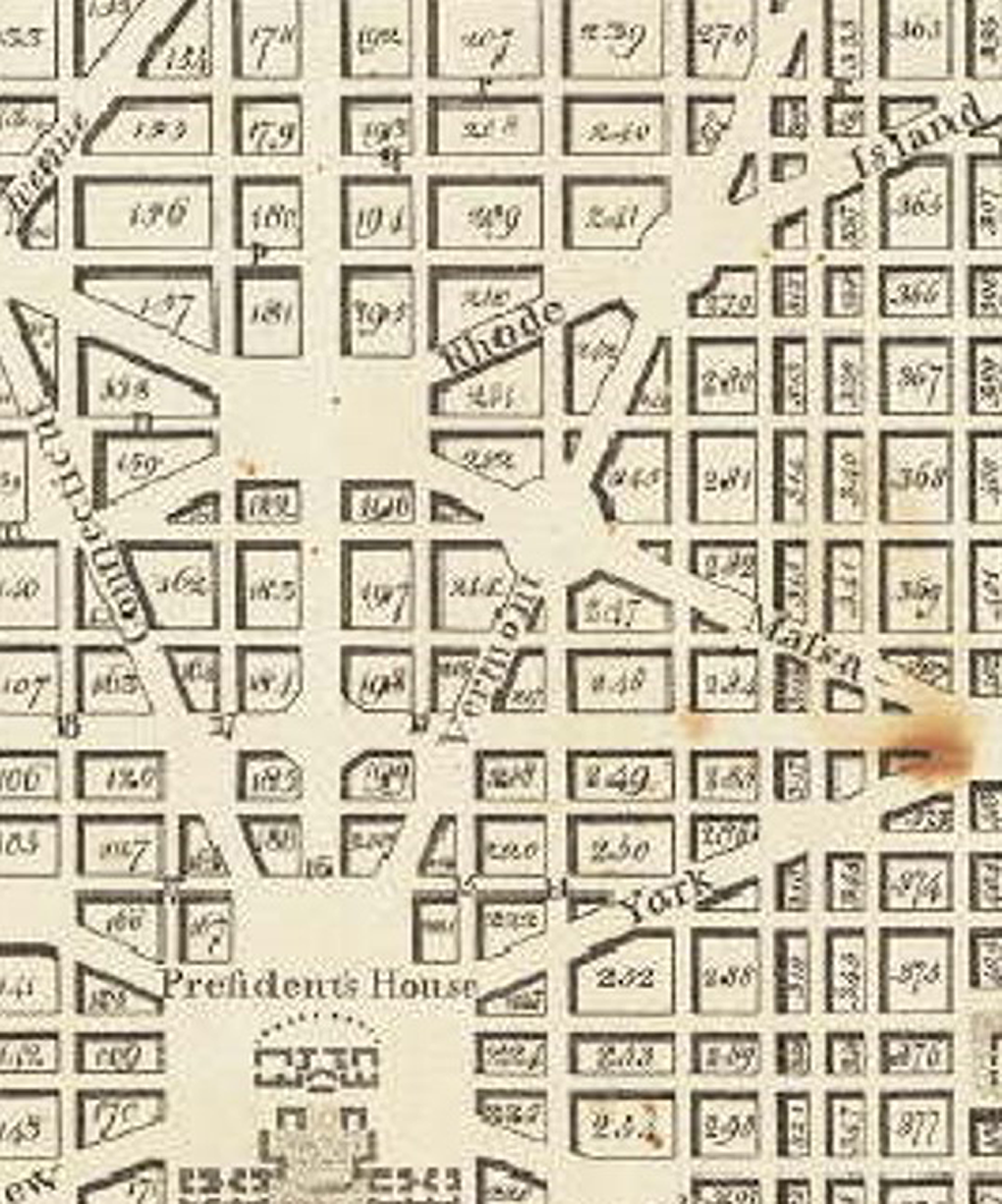
The district of Rhode Island Waterways—numerous tributaries of Tiber Creek. Context—adjacent to the escarpment to the north. Access to fresh water—has one existing spring. Elevation—the public square—a rectangle—is on the highest ground of all fifteen public squares. Prospect—the most favorable views would be toward the escarpment, the district of Rhode Island’s public square, and the city center.
The district of New York Waterways—numerous tributaries of Tiber Creek. Context—adjacent to the federal buildings including the National Church to the south. Access to fresh water—has two existing springs (Blue House Spring and Leech Spring) and a proposed Grand Fountain. Elevation—the public square—a rectangle—is about the same elevation as the President’s House. Prospect—the most favorable views would be toward the districts of Vermont’s and New Jersey’s public squares, the President’s House, and the National Church.
The district of New Jersey Waterways—numerous tributaries of Tiber Creek. Context—adjacent to the federal buildings including the Judiciary to the south. Access to fresh water—has two existing springs (Willow Spring and Reedbirds Hill Spring). Elevation—the public square—a rectangle—is surrounded by three low hills. Prospect—the most favorable views would be toward the district of New York’s public square and the Congress House.
The open district between New Jersey and Massachusetts/Maryland Waterways—numerous tributaries of Tiber Creek. Context—adjacent to the escarpment to the northeast. Access to fresh water—tributaries of Tiber Creek. Elevation—the public square—a rectangle—overlooks the confluence of two Tiber Creek tributaries. Prospect—the most favorable view would be toward the Congress House.
The district of Massachusetts Waterways—numerous tributaries of Tiber Creek. Context—adjacent to the Congress House to the south and the Mile Column to the east. Access to fresh water—has a proposed Grand Fountain. Elevation—the public square—an oval—is located on the northern edge of Jenkins Hill. Prospect—the most favorable views would be toward the district of Maryland’s public square, the Congress House, and the Mile Column.
The district of Maryland Waterways—numerous tributaries of Tiber Creek and Cool Run. Existing infrastructure—an existing road connecting Bladensburg, Maryland, and the ferry (future drawbridge) over the Eastern Branch. Context—adjacent to the Mile Column to the south. Access to fresh water—has one existing spring (Gibson Spring) and a proposed Grand Fountain. Elevation—the public square—a rectangle—is located between the foot of Jenkins Hill and the escarpment to the northeast. Prospect—the most favorable views would be toward Massachusetts district’s public square, the Mile Column, and the escarpment in the state of Maryland.
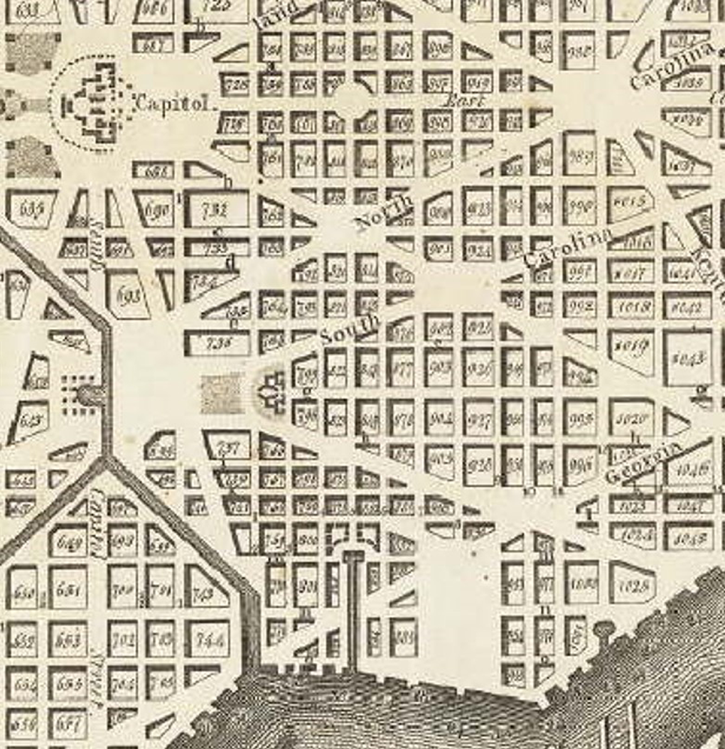
The district of Pennsylvania Waterways—the Eastern Branch with numerous tributaries. Existing infrastructure—an existing road connecting Bladensburg, Maryland, and the ferry (future drawbridge) over the Eastern Branch. Context—on the bank of the Eastern Branch. Access to fresh water—the Eastern Branch. Elevation—the public square—a rectangle—is located on the east side of Jenkins Hill about ten feet below the elevation of the Congress House. Prospect—the most favorable views would be toward the district of North Carolina’s public square and the Eastern Branch.
The district of Georgia Waterways—the Eastern Branch with numerous tributaries. Context—on the bank of the Eastern Branch. Access to fresh water—the Eastern Branch. Elevation—the public square—a rectangle—is located on the bank of the Eastern Branch. Prospect—the most favorable view would be toward the Eastern Branch.
The district of North Carolina (Figures 10
–12) Waterways—numerous tributaries of St. James Creek and the Eastern Branch. Existing infrastructure—an existing road connecting Bladensburg, Maryland, and the ferry (future drawbridge) over the Eastern Branch. Context—adjacent to the Canal to the west, Congress House to the northwest, Mile Column to the northeast, and the Eastern Branch to the south. Access to fresh water—has three existing springs (Carroll Spring) and a proposed Grand Fountain. Elevation—the public square—an oval—is located on Jenkins Hill at about the same elevation as the Congress House. Prospect—the most favorable views would be toward Pennsylvania district’s public square, the Congress House, Mile Column, and the Eastern Branch.

Detail of L’Enfant District of North Carolina’s Public Square—No. 14. Plan of the city intended for the permanent seat of the government of the United States. P. C. L’Enfant, 1791, Facsimile by the US Coast and Geodetic Survey Office (1887). Public domain image from the Geography and Map Division, US Library of Congress.
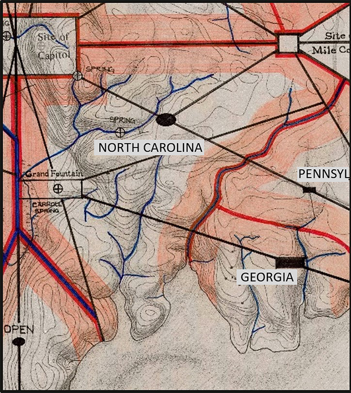
Detail of the District of North Carolina. Topography of the federal city, 1791, with L’Enfant’s plan overdrawn by author. D. Hawkins, 1990, Public domain image from the Geography and Map Division, US Library of Congress.
Detail of the plan of the city of Washington. A. Ellicott, Printed by Thackara & Vallance, Philadelphia (1792). Public domain image from the Geography and Map Division, US Library of Congress.
The open district between North Carolina and Delaware Waterways—the Eastern Branch with numerous tributaries and St. James Creek. Context—adjacent to the Canal to the west and the Eastern Branch to the east. Access to fresh water—the Eastern Branch. Elevation—the public square—an oval—is aligned with the north–south axis of the city. Prospect—the most favorable views would be toward the Congress House and the Eastern Branch.
The district of Delaware Waterways—Potomac River and St. James Creek with numerous tributaries. Context—adjacent to the Potomac River to the west, Congress House to the north, and the Canal to the east. Access to fresh water—Potomac River and St. James Creek. Elevation—the public square—a rectangle—is on the highest elevation within the area. Prospect—the most favorable views would be toward the district of Virginia’s public square, the Congress House, and the Potomac River.
The district of Virginia Waterways—Potomac River. Context—adjacent to the Potomac River to the southwest and the Grand Avenue (now the Mall) to the north. Access to fresh water—Potomac River. Elevation—the public square—a rectangle—is on the highest elevation within the area. Prospect—the most favorable views would be toward the district of Delaware’s public square, the Grand Avenue and National Church beyond, and to the Potomac River and Virginia beyond.
Frustration and Dismissal
Unfortunately for L’Enfant, the lot sale on October 17 did not go well. Only thirty-five lots were sold raising $2,000, which was considerably less than expected. 59 One reason for the poor result was because L’Enfant withheld his drawing and prospective purchasers were unsure of the exact location of the land they wanted to buy. This, and other complaints, prompted the Commissioners to start moving toward L’Enfant’s dismissal. On October 21, 1791, the Commissioners asked Washington to propose a sum that would satisfy L’Enfant’s service to date. Two months later, in a letter to the Commissioners dated December 18, 1791, Washington defended L’Enfant and said, “The work of Major L’Enfant, which is greatly admired, will show that he had many objects to attend to and to combine, not on paper merely, but to make them correspond with the actual circumstances of the ground.” 60
By all accounts, L’Enfant fully intended to have his design printed in time for the October sale. When the Philadelphia printer could not obtain a copper plate of sufficient size, L’Enfant wrote to Washington saying that the printer was not at fault and hoped the lot sale would be postponed even though he feared speculators would run up the cost of land. However, the Commissioners were very concerned with the lot sales and needed a printed drawing. They directed Ellicott to redraw the plan for printing. L’Enfant, on the other hand, knew his design and insisted on proceeding with its execution without a printed plan. For instance, on December 2, L’Enfant bought Aquia Creek sandstone quarry, which is twenty miles south along the Potomac River, for £1,800 (about $6,000), and hired cutters to start supplying the stone needed for constructing government buildings. In late December, L’Enfant left George Town for Philadelphia to supervise engraving the plan with instructions for Ellicott, “to delineate on paper all that had been done in the city” so it could be the basis for drawing the remainder. 61 Once there, L’Enfant offered to correct the drawing in progress, but Ellicott refused.
On January 17, 1792, perhaps assuming the issues with printing the drawing would be resolved, L’Enfant wrote a report listing the operations and estimated costs for labor and materials to construct his design. 62 L’Enfant outlined infrastructure projects to establish sources for obtaining building materials, transporting them, and refining them for construction. Barracks were to be built in four locations for 600 to 800 men working on the Federal Square and President’s Square along with a commissary to feed them. Aqueducts, bridges, and a canal had to be built along with barges to transport brick and stone. Also needed were mills to grind the plaster of Paris cement and kilns to fire clay blocks into brick. People were to be hired as loaders, stone masons, metal workers (to make iron tools), and overseers, along with carpenters to build wheelbarrows and wagons, and others to operate the commissaries. 63 For the first four-year building phase, L’Enfant estimated the cost at $300,000 per year for a total of $1,200,000. Subtracting the $200,000 grants from Virginia and Maryland, L’Enfant recommended the United States borrow $1,000,000 from Dutch banks with the Commissioners serving as “sponsors,” that is, personally guaranteeing the loan.
This last effort was insufficient to salvage L’Enfant’s job and reflects his unrealistic expectations and misunderstanding of the whole situation. Jefferson discharged L’Enfant in a letter on February 26 or 27, 1792. Three reasons were stated for the dismissal: L’Enfant had refused to hand over his drawing for the October lot sale; he had the newly started house of Daniel Carroll of Duddington, a nephew of Commissioner Daniel Carroll, demolished the previous November because it was located in the proposed New Jersey Avenue at a cost of $45,000 to the federal government; and he had slandered the Commissioners calling them ignorant and unfit, refused to work under them any longer, and demanded that he report to President Washington alone despite Washington and Jefferson having repeatedly explained the impossibility of such a change under the Residence Act. 64
A week later, on March 6, 1792, Jefferson wrote to the Commissioners saying Washington thought $2,500 or $3,000 was appropriate payment for L’Enfant’s services to date but that he would leave the final decision to them. In another letter dated March 8, Washington wrote to Commissioner Stuart saying 500 guineas (about $2,725) and a lot in a good part of the city would be the right compensation. L’Enfant accepted none of their proposals and did not seek compensation for his design until after Washington died in 1799. He then submitted a total of ten requests to Congress starting on December 24, 1802. L’Enfant asked for $8,000 for one year’s labor plus $37,500 for the profit he had a right to receive from the sale of the engraved plan plus $50,000 for “perquisites of right in particular negotiations and enterprise,” for a total of $95,500. A congressional bill on April 27, 1810, finally resolved this matter and awarded L’Enfant $666.66, plus interest from March 1, 1792, for a total of $1,394.20, which was promptly claimed by his creditors. 65
Ellicott’s Alterations
With L’Enfant no longer involved in the project, Jefferson had Samuel Hill of Boston print 4,000 copies of a slightly smaller version of Ellicott’s drawing by July 20, 1792. 66 On November 13, 1792, Thackara & Vallance, Philadelphia publishers, delivered a full-sized engraving of Ellicott’s drawing complete with depth soundings of the two rivers and 1,146 numbered blocks, along with a simplified text from the Explanatory Notes that L’Enfant included on his drawing (Figure 13). Neither engraving identified L’Enfant as the urban designer.
Plan of the city of Washington. A. Ellicott, Printed by Thackara & Vallance, Philadelphia (1792). Public domain image from the Geography and Map Division, US Library of Congress.
There is no doubt among scholars that much of the elegance and subtlety of L’Enfant’s urban design was lost when Ellicott took the surveying information he knew, along with a general understanding of L’Enfant’s design, to redraw and thereby redesign, the federal city plan. Lewis observes, “Where L’Enfant had allowed for rolling hills and grade variations to lend an individuality to the various squares, Ellicott leveled the land…” 67 and regularized the subtle geometry of L’Enfant’s radial and diagonal avenues. Miller notes L’Enfant’s understanding of spatial perception responded to topographic variations, which meant the overall effect of the design provided open spaces for public use, broad avenues for the free flow of air and views, and a highly livable city. The result of Ellicott’s changes, Miller continues, was that “twelve civic reservations [public squares] and five radial avenues were eliminated; public sites were reshaped; and five stately fountains, placed at strategic ‘gateways,’ were deleted.” 68 Avenues were shifted or aligned, and public square no. 15 was omitted. Where L’Enfant’s design had six public squares located to the side of the intersection of two avenues or next to only one avenue, Ellicott’s plan moved every public square to the intersection of at least two avenues, and in three cases, where three avenues intersect. This change reversed the emphasis of the design, making straight avenues the dominant feature rather than public squares located based on topography and proximity to fresh water. Ellicott’s more regular geometry also ignored the spacing L’Enfant sought to provide a reciprocity of sight that would connect the cultural and economic center of each representative state district. Most regrettably, the Congress House was turned to face east instead of west and repositioned, so that a building and not the great Congress Square, a public civic space, was the center of the city.
Conclusion
L’Enfant’s design, if built as planned, reflected the characteristics of its specific location. This work remains relevant because L’Enfant used the landscape to situate individual districts with a strategy to unite them into a whole design. If L’Enfant had been able to build his proposed design, at any pace, the result might have been a city where the federal government and each state’s interests could be more accurately and fairly known. Nevertheless, as Gutheim concludes about the city as built, “The remarkable dynamism and vitality to which the city owes its present character and appearance seems most traceable to the shrewd topographical realism of the plan: its management of streams, drainage, and river frontages, and its recognition of ridges, terraces, and most of all, strategic heights of land which were to become the sites of major public buildings.” 69 This becomes evident when L’Enfant’s plan is overlaid on Hawkins’ topographic map that shows the situation in 1791. L’Enfant conceived of these individual but visually linked state districts as a metaphor that balanced, in built form, the competing ideals of regional culture and federal unity.
Footnotes
Acknowledgments
The author is grateful to Walton Moody, a discerning historian, and Diane Ivone, a gentle editor, for their keen reading and insightful comments on early drafts of this article. I also thank Todd Gilens for his thoughtful and skillful editorial comments.
Declaration of Conflicting Interests
The author(s) declared no potential conflicts of interest with respect to the research, authorship, and/or publication of this article.
Funding
The author(s) received no financial support for the research, authorship, and/or publication of this article.