






Abstract
The infamous “security maps” made in the 1930s by the Home Owners’ Loan Corporation (HOLC), rating supposed mortgage lending risk in urban neighborhoods across the United States, have long been considered the quintessential expression of racist redlining policy. However, a number of misunderstandings and unwarranted speculations about how these maps were made and used have proliferated. Using previously unexamined correspondence, this article establishes that HOLC could not have used the maps for loan denials, did share them with the Federal Housing Administration but not with private industry, and highly improvised their production with numerous methodological inconsistencies, including with regard to race.
Writing back to Home Owners’ Loan Corporation (HOLC) headquarters in late March 1936, Field Agent Alec Morgan with its Mortgagee Rehabilitation Division (MRD) confirmed receipt of some items he had requested for his work on the agency’s City Survey. “[R]egarding use of brown pencils,” he explained from Birmingham, Alabama, “although we no longer make racial maps at the same time I have the local real estate men furnish me this information so that I can make an intelligent discussion of the location of the negroes in my reports[.] [M]ost of the cities that I survey have from thirty to fifty per cent negroes so you can understand why consideration of them cannot be eliminated entirely.” By mid-May, his initial interviews with local banking and real estate industry personnel were nearly complete, so he had begun working on a highly detailed report and an accompanying mortgage “security” map grading the supposed riskiness of lending in Birmingham’s various neighborhoods. 1 After two months, the report and Morgan’s hand-finished, four-color map was complete. However, the MRD’s manager Corwin A. Fergus thought the time he had taken was excessive. “Frankly I do not know exactly what is the trouble,” Morgan wrote back, defending himself as “naturally a slow, methodical worker.” Despite receiving help from one of the city’s most prominent real estate and insurance brokerage firms, Morgan explained, “We have worked four mornings from seven until ten and I think it will take about two more to complete the ninety-seven sections into which the map is divided.” 2
Despite the burgeoning interest in and awareness of the practice of “redlining” in recent years—that is, the targeted denial of loan monies or other financial supports to designated areas, typically on the basis of race—these intimate glimpses of the work underlying the City Survey are completely unprecedented. They come from a virtually unexamined set of records: the General Administrative Correspondence of the HOLC. A New Deal agency that refinanced the mortgages of around 1 million American homeowners in the depths of the Great Depression, HOLC has become notorious for commissioning an extensive series of neighborhood-level maps for over 200 US cities, rating the supposed viability of mortgage lending. 3 Besides revealing rich and previously unknown details about how exactly the agency conducted the now-infamous City Survey from 1935 to 1940, these records can help to resolve long-standing questions about why the maps were made. More importantly, they provide a nuanced and necessary correction to some sweeping assertions that have been made about the HOLC and redlining since the program’s existence was uncovered in the late 1970s. To be sure, these assertions have broadened the conversation and spotlighted the federal government’s role in promoting discriminatory, race-based lending. However, a closer look at the archival record makes clear that a reassessment is in order, in terms of what the City Survey maps did and what they could not do.
Extant only on uncatalogued microfilm at the National Archives II in College Park, Maryland, HOLC’s General Administrative Correspondence poses daunting research challenges, which explains why the records have gone overlooked for so long. 4 All things considered, scholars have done a laudable job in piecing together the outlines of the agency’s City Survey program. 5 To summarize the most signal developments, Kenneth T. Jackson was the first to discover the maps after delving into the hundreds of boxes of HOLC records at the National Archives. In two articles later adapted as a chapter in Crabgrass Frontier, Jackson offered a general background of the City Survey and sketched its local expressions in Saint Louis, Newark, and Memphis. 6 Without the benefit of the General Administrative Correspondence records, geographer Amy Hillier was nonetheless able to deduce the basics of how HOLC surveyed and re-surveyed Philadelphia from 1935 to 1937. 7 James Greer uncovered additional details about the City Survey by examining minutes of the Federal Home Loan Bank Board (FHLBB) that oversaw HOLC, as well as speeches given by some of the higher-level administrators involved with the program. 8 Historian Ocean Howell’s initial foray into the General Administrative Correspondence microfilm revealed that different strategies had been used for the San Francisco and Los Angeles surveys, yielding disparate assessments of Mexican American neighborhoods. 9 Finally, scholars with the Mapping Inequality project, an interactive website launched in 2016, made national comparisons vastly easier by digitizing nearly 200 City Survey maps and their accompanying neighborhood worksheets. 10
However, lacking granular information about the City Survey program’s operations, previous researchers have had to rely disproportionally on speculation. Considering HOLC’s dim view of property values in African American neighborhoods and the explicit, racially informed commentary in the maps’ accompanying documentation, many scholars quite reasonably assumed that their main purpose must have been to exclude African Americans and other racial minorities from participating in HOLC’s mortgage refinancing program. That notion turns out to be incorrect. In fact, nearly 24,000 African American homeowners received HOLC assistance in rough proportion to their ownership rates and in many locales actually received more than that. 11 Some observers have struggled to reconcile mounting evidence that HOLC made the majority of its loans in the lowest-rated areas—“C” (yellow) and “D” (red)—despite Jackson’s identification of this counterintuitive pattern early on. 12 Similar incredulity has accompanied the revelation that the majority of “D” (red-rated) areas were actually not African American neighborhoods, a fact that can now be easily discerned by a cursory exploration of Mapping Inequality’s website. 13
In contrast, other scholars have argued these findings indicate a less significant role for race in HOLC’s operations, an interpretation some critics have regarded as an attempt to “absolve” the agency of racism. This newer tendency of deemphasizing race also relies on speculation in the face of scarce primary source evidence and uses social scientific, statistical analysis that treats race as a variable independent from the age and condition of housing. 14 Such approaches insufficiently appreciate that for most of the twentieth century, African Americans were relegated by various legal and extralegal means to the oldest urban housing stock; therefore, race is better understood as a "confounding" factor rather than as a truly independent variable. Moreover, HOLC may have rated nonblack residents living in “D” areas—very often Southern and Eastern European immigrants—the same as African Americans, but simply accepting this categorization fails to recognize that they did not face analogous constraints on their housing options. Therefore, the conclusion that race must not have mattered as much as previously assumed is unwarranted. It is far more important that virtually all black neighborhoods were rated “red” than the fact that not all “red” neighborhoods (nor even most) were African American. 15
HOLC’s General Administrative Correspondence offers answers to many questions that have vexed past inquiry. The following look at the MRD’s first year of operations can provide the basis for a new understanding that more precisely delineates how racial considerations guided its mapmaking and survey methodology. As Amy Hillier has noted, HOLC did not invent redlining, in the sense that using maps to evaluate loan decisions was already becoming standard practice at the time. 16 So, why did HOLC make the City Survey maps if not specifically to deny loans in nonwhite neighborhoods? As several scholars have observed, HOLC utilized numerous other channels to disseminate its damaging, racialized thinking about property values. 17 Surprisingly, the image that emerges from these uncatalogued records is of a shoestring operation in search of a mission. HOLC’s City Survey upon its debut was nothing whatsoever like a highly organized effort with extraordinary powers to reshape the country’s housing market. Instead of proceeding with a clear and consistent logic from the outset, the survey’s methodology and execution were more often characterized by improvisation, inconsistency, and arbitrariness, including on questions of how race fit into the picture.
Origins and Setup of the City Survey Program
Revisiting the timing of HOLC’s refinancing loan operations relative to the launch of the City Survey can address any lingering questions of whether the agency could have used the maps to deny federal aid to African Americans and other racial minorities. A common misunderstanding has been a failure to distinguish HOLC’s two phases: its “rescue” phase, lasting from 1933 to 1936, followed by “consolidation” from 1936 until the agency’s ultimate liquidation in 1951. During the rescue phase, HOLC refinanced struggling homeowners behind on their mortgage payments, simultaneously recapitalizing their creditors. The City Survey project was initiated later, during the consolidation phase. However, the slight chronological overlap of the two phases has prompted some scholars to add the qualification that “most” of HOLC’s loans were already issued by the time it began making maps 18 ; meanwhile, the belief persists that the agency used these maps to deny refinancing loans on the basis of race. Two dates are relevant to the matter at hand: June 1935, the deadline Congress set for HOLC loan applications, and June 1936, when the last of these loans were closed. Since work on the City Survey did not begin until September 1935, it can be said with certainty that by then, HOLC had closed fully 90 percent (920,026) of its loans. 19
Although the origins of HOLC’s MRD remain somewhat shadowy, the initiative was allegedly “centered” in FHLBB Chairman John H. Fahey’s office 20 and arose from a partnership between two men: James F. Twohy and Charles H. Stewart. Twohy joined the FHLBB in 1934, leaving behind his railroad contracting and manufacturing business in the Pacific Northwest, while Stewart had already ascended to the leadership of Portland’s Federal Home Loan Bank in 1933. 21 By February 1935, the FHLBB had organized a “Mortgagee Rehabilitation Department,” but it consisted only of a three-man “Managing Committee”: Stewart, Twohy as “Chairman,” and the former Columbus, Ohio, realtor and bank liquidator Corwin A. Fergus. 22 HOLC administrators likely recruited Fergus following a late 1933 trip to Dayton, where they had worked with him to retire Reconstruction Finance Corporation loans. He soon demonstrated his investigative prowess by singlehandedly completing a detailed survey of Detroit’s real estate landscape, presaging the work and format that the City Survey would later take. 23
Fergus became Acting Manager of the Mortgage Rehabilitation Division after the FHLBB finally established it through resolution on August 27, 1935. 24 Although the resolution did not include a budget, it specified hiring Field Agents to pursue the Division’s objectives in each of HOLC’s eleven regions who would report directly to Fergus. At least for the moment, the MRD’s existence—as well as its final products—was to remain strictly confidential. Only Regional Managers were notified, who were expected to provide field agents with office space, necessary equipment, and stenographic support. 25 With HOLC’s lending activities winding down, Regional Managers were scrambling to maintain regular operations amid layoffs, and so many were less than enthusiastic in their support of the MRD’s City Survey work. “Compiling data that they have wanted has taken a material amount of time of our personnel, particularly in the Accounting and Servicing Departments and has necessitated overtime work,” one manager complained. 26
The secrecy surrounding the City Survey’s debut partly explains the lack of support from Regional Managers. Initially, only FHLBB’s top leadership was authorized to review the project’s resulting reports and maps. And surprisingly enough, at the outset even these higher-ups were largely indifferent to the massive volume of highly detailed information being produced. Fergus recalled that by November 1935, “it was apparent that an analysis section was necessary…because the reports from the field were lengthy and the chief executives did not have the time to read them.” 27 Accordingly by March of the following year, the MRD tasked a Washington staffer with the job of distilling these. 28 By February 1936, Fergus finally secured permission for a wider sharing of City Survey materials, with security maps first and reports later so that sensitive or identifying information could be removed, a process that would drag on into that October. 29
So even if HOLC’s State and Regional offices received their initial security maps immediately upon authorization in February 1936, fully 97 percent (986,994) of the agency’s refinancing loans had been closed by that point. 30 Moreover, by the end of its first fiscal year in June 1936—the same month that HOLC finished closing all its loans—the MRD had completed surveys of ninety-two cities, only about half the total. 31 The small number of map copies that HOLC’s Washington office initially shared, due to confidentiality concerns and the difficulty of reproducing the originals, makes it beyond unlikely that these could have been used by appraisers or loan officers in any systematic way to evaluate the remaining loan applications. As will be seen, the MRD itself quickly abandoned early efforts to use the maps for loan categorizing purposes, because of how time consuming it was to pinpoint individual borrowers. However, while the foregoing should dispel the persistent misconception that HOLC used these redlining maps to deny nonwhite borrowers access to refinancing loans in its initial “rescue” phase, the possibility remains that the agency used them in racially discriminatory ways at a later point.
If not for loan denials, then why did the MRD make the maps, and in a related question, why was this mysterious unit established in the first place? Scholars have offered general context in lieu of definitive answers here, as in Ocean Howell’s evocative observation that HOLC undertook the City Survey “so that it might better understand what it had already bought—and how it might plan to safeguard its investments.” 32 HOLC’s enabling legislation did not preclude any such project, James Greer has pointed out. 33 And since HOLC fell under the jurisdiction of the FHLBB, the MRD’s work had potential implications as “guidance” for the savings and loan institutions under its purview, as well as for the Federal Savings and Loan Insurance Company backing them up. “The board [FHLBB] considered minimizing the risks involved in mortgage lending by these local associations and ‘helping to protect them against adverse trends’ to be its responsibility,” Amy Hillier has written. 34
These broad assessments have relied on a handful of scarce and opaque mentions of the MRD in published sources. The FHLBB’s annual reports from the mid-1930s offer few specifics. The one for the 1935–1936 fiscal year again mentioned the MRD’s work in relation to the winding down of HOLC’s loan program and FHLBB’s ongoing work with savings and loan associations. Although not specifically named, it referred to the MRD’s “[n]ation-wide survey of mortgage and real estate conditions” in cities of over 40,000 inhabitants. By the time of the 1936–1937 annual report, the MRD had been consolidated into FHLBB’s Division of Research and Statistics even as its survey work continued. This time the template for City Survey reports was summarized but with no mention of the accompanying security maps; “type of population and trends” is the only hint that the project had a racial dimension. However, this annual report at least gave a sense of how HOLC and the FHLBB were using the City Survey materials by then, specifically “[so] that the Board and the administrative officers may formulate sound policies in regard to the approval of financial institutions for membership in the Bank System, for federalization, for insurance of shares, and for H.O.L.C. share investments[.]” Gathering local-level real estate and home financing data was considered crucial if policymakers were to avoid making any “erroneous decisions.” 35
One urgent, politically sensitive, and unpublicized need that was rife in HOLC’s internal discussions at the time was property management—collecting payments from its mortgagors, foreclosing on delinquent borrowers, and maintaining, renting, and gradually selling properties it accumulated with an eye on eventual liquidation. The seeming mundaneness of such motivations has led at least one observer to discount them in search of grander objectives, but they were very real concerns as the agency pivoted away from its rescue phase. 36 After all, fully one-fifth of all HOLC borrowers ultimately defaulted. Some of the most candid expressions here came from the MRD’s field agents themselves. One wrote, “Our intelligent handling of this problem will be of extreme importance to the stability of real estate values upon which private lending agencies have already made loans or will base their future investments.” 37 With the overall situation in mind, another agent opined: “Our work is not nearly complete, and cannot be, until all local institutions thruout [sic] the country have liquidated their delinquencies and acquisitions, not by [a] dumping process, but by gradual helpful cooperation, following which the corporation may ease back into private hands, its mortgages and acquisitions.” He concluded: “[S]uch a program cannot be accomplished by a too hard-boiled foreclosure program on our part without serious damage to ourselves, and others.” 38 The private industry contacts approached certainly had this context in mind, like one loan supervisor who assumed the MRD was gathering information “in connection with a possible liquidation program for the real estate acquired by your corporation.” 39 HOLC finally formed its Property Management Division in January 1936 to satisfy such needs. 40
MRD co-organizer James Twohy stated early on that the unit was set up “for the purpose of assisting in every way possible the restoration of home finance agencies on a normal and private basis.” 41 Just what he meant by this can be discerned from some of the unexplored objectives named in the unit’s August 1935 enabling resolution. While the MRD was explicitly charged to “[m]ake surveys of real estate and home mortgage problems,” its other goals speak to Twohy’s emphasis on “rehabilitating” the country’s home mortgage financing industry. These included: “[to] collect and disseminate information on successful methods of disposal of real estate owned by mortgage lending institutions”; to determine the extent to which private institutions were lending or else shifting the “burden” onto federal agencies like HOLC; to make recommendations about how to stimulate homeownership; to determine “where there has been a general breakdown of the functioning of mortgage lending institutions” and support their ongoing reorganization however possible; and to help encourage life insurance companies, mutual savings banks, and other large institutional lenders to “continue to carry distressed mortgagors.” These objectives make clear that HOLC’s concern was less with the loans it already held but rather the prospect of having to assume additional home mortgage debt in some future authorization. As for the last of these, the MRD and the FHLBB more generally were hopeful that insurance companies might resume lending and perhaps even be enticed to expand their mortgage portfolios in a revamped, more “secure” mortgage market increasingly characterized by long-term amortized loans. 42 Tapping insurance companies’ large capital reserves would foster the emergence of a truly national secondary mortgage market, which would not otherwise become a reality until 1938 when Congress established the Federal National Mortgage Association (“Fannie Mae”).
It is helpful to know more about the structure of the MRD, the backgrounds of its personnel, and the scope of their interactions over the course of its work. During its first year of operations, the MRD’s staff consisted of just twenty-two persons. 43 Corwin Fergus served as Manager for the duration. That year, his compensation was $8,000—approximately $142,000 today—meaning his salary approached those of the highest tier managers at FHLBB-HOLC. 44 Assisting Fergus in the Washington office were at least four managerial assistants who evaluated materials produced by the field agents and were occasionally deployed to the field. 45 The two most active Washington staffers were Walter N. Ruth, a Baltimore-based investment banker and real estate developer, and Clifford C. Boyd, who had worked in the same Columbus, Ohio real estate firm as Fergus and was his most trusted advisor. Boyd began as one of the original field agents but was later recalled to Washington to oversee the City Survey’s operations. 46
The field agents who conducted the city surveys, one in each of the eleven HOLC Regions or two in the heavily urbanized Northeast, fit a predictably consistent profile. Described by Fergus as “high-priced men” with salaries in the range of $4,000 to $4,500—$73,000 to $82,000 today—it was imperative that “Very careful consideration should be given…to the[ir] appearance and personality…bearing in mind that they are to be in constant contact with the public.” 47 Unsurprisingly, of the initial thirteen men hired, all were white and native-born. While their ages ranged from thirty-four to fifty-seven, most were in their forties. They were college-educated from generally well-off backgrounds. 48 At least one, a former New York stockbroker, came from old money as the son of a steel magnate, while another seems to have worked his way up from auto supplies salesman to stockbroker. 49 At least eleven had previous careers in banking or finance. Probably most of these men took jobs with the MRD because of Depression-related setbacks or diminished career opportunities for men of their stature.
Fergus expected the field agents to impress him, and he granted them considerable independence in conducting their work. For example, while the larger cities were supposed to be surveyed first, Fergus allowed the field agent in charge of Texas to prioritize his surveys in a way that made logistical sense. 50 Field agents determined the geographic scope of each survey on either a city or a metropolitan basis and resolved any resulting complications. Fergus told one agent in charge of Saint Louis, a border city, to first “determine whether or not the various lending agencies have been crossing state lines” before deciding whether “one or two reports will be best.” 51 For Los Angeles, Fergus supported the agent’s decision to proceed on a countywide basis despite the much greater amount of work involved. 52 Initially, Fergus declined to suggest any organizational schema for the survey reports, explaining to one: “I purposely did not give you an outline because I wanted to see what you would do alone.” 53
Far from some master plan imposed from above, the MRD improvised its approach to the City Survey as it went along, with Fergus actively soliciting his field agents’ feedback. He occasionally invited their critique on the unit’s reports and summaries, and clearly regarded some field agents more highly than others. 54 He commended agent Lloyd N. Wheeler, who had longstanding prior experience as a Detroit mortgage broker, writing “I know of no one who is better equipped to offer suggestions and enter into some discussions with me.” 55 And he scolded the diligent but often tardy Alec Morgan, “If you don’t hit the ball for me my pride in being able to pick men is going to suffer a very severe blow.” 56 Fergus did not insist that the agents always follow his advice, once admitting they were “working in more or less of a brand new field” and emphasizing that he welcomed their input. He continually sought ways to refine and standardize results. 57 Operating in uncharted waters, Fergus depended on field agents to pass along any actionable information and in some instances allowed them to make actual policy-shaping decisions. Agent Wheeler, upon uncovering that several of the largest real estate companies in Detroit were meeting collectively, took the initiative to bring the Regional Manager in on these conversations, only telling Fergus afterward. And another agent liaised with a visiting US Senator, gleaning insider information about a pending proposal to merge the federal government’s various housing-related agencies. 58
Conducting the Surveys, Making the Maps
Field agents used various strategies to gather data for the City Survey. Before even arriving on location, they collected published reports and whatever information private entities were willing to share. Upon arrival, field agents often dove into whatever public records were available, whether at city engineers’ and surveyors’ offices or at the recorders of deeds and clerks of courts. 59 After complaining about a lack of cooperation from the Lansing Chamber of Commerce, Agent Wheeler explained he “personally check[ed] the Court House records for transfers and foreclosures, City Hall records for building permits, taxation delinquencies, and individual institutions for income of people.” 60 However, availability and access to data varied considerably from city to city, leading Fergus to acknowledge that “some of the information which we are requesting will be difficult, and in some cases almost impossible, to obtain.” 61 Agents made productive use of statistics and maps compiled by state governments and other federal agencies such as the Civil Works Administration, Works Progress Administration, and Federal Housing Administration. 62
The detail-rich surveys as well as Fergus’ public boast of 10,000 contributors has led scholars to surmise that the City Survey relied on cooperation from local financial institutions and real estate firms. 63 Now we know how the MRD accomplished such a feat. Initially, Fergus and field agents had expected to gather much of the survey information through correspondence. Advance inquiries could be paired with in-person follow-up interviews, as explained by C. C. Boyd: “I have found it was best for me to assemble my facts and figures before I attempt interviews…You are then able to judge whether the speaker is handing you a true or distorted story. And you have learned, who are the better ones to interview.” 64 Dozens or even hundreds of informants in a given location were approached in this way, with the city’s scale often determining the strategy. 65 Agent Wheeler noted that unlike in Lansing, where he had contacted literally every lending institution, in Detroit “[I]f we take the four or five largest insurance companies, a few of the largest banks, and the largest institutions in liquidation, we will have a picture complete enough to tell the entire story.” 66 T. H. Bowden observed of the Los Angeles area’s 4,000 real estate brokers: “It was, of course, impossible to cover any such number, consequently a list of 200 names was selected and the questionnaire sent to them.” 67 Two hundred contacts seems to have been the uppermost limit for large cities—which is where the agent in charge of Chicago similarly settled. 68
In their form letters requesting information, field agents conveyed a sense of urgency while appealing from a fellow investor’s perspective. One agent who wrote “all concerns in Memphis” had claimed “it was necessary…that they rush [the forms] to me as speedily as possible.” 69 “For reasons we presume are perfectly apparent to you,” another wrote, “our Corporation is anxious to get specific data concerning mortgage loan and real estate conditions in your City.” Yet another assumed familiarity with and approval of the federal government’s recent housing policy interventions: “You will readily appreciate how important are the various agencies operating under the Federal Home Loan Bank Board as factors in the recovery of the real estate and mortgage loan market and will therefore understand the benefits which will accrue to your community and to your business through the work which I am seeking to do. It is upon this basis that I ask for your active cooperation.” 70
But private industry did not leap at the chance to collaborate on the City Survey, as the slow pace of responses and a reluctance to comply soon tested the field agents’ patience. “I am convinced that the delays hereafter are going to be in having these forms filled out by the Institutions. Very few of them are equipped to give information promptly” reported one agent; another confirmed that two weeks for a response was typical. 71 Believing it wasn’t “worthwhile” to expect any more than ten replies from Milwaukee’s sixty-seven building and loan institutions, an agent informed Fergus he was sending in whatever responses he had. 72 Such delays created dilemmas about how to stage the required work. Under intense pressure from Fergus to complete their assignments in a timely manner, field agents typically traveled between cities while gathering and awaiting information and worked on more than one survey at a time. 73
Various factors explain institutions’ lack of enthusiasm. While some flat out refused to cooperate on grounds of confidentiality, one field agent was not alone in his assessment that an “unwillingness to take the time” was more typical. 74 Another agreed that inconvenience explained much of the recalcitrance, adding that informants “felt that the result would be of no interest to the Board [FHLBB]” and that many banks were “not interested in real estate lending” due to the Depression. 75 To the agents’ frustration, some lenders shared only selective figures; others contributed information that did not match the MRD’s specifications, with one agent reporting “Most of the institutions do not keep separate reports covering information on residential mortgage transactions.” 76 Some field agents adopted personal touches to gather desired information. Raymond L. Olson concluded the best strategy was to drop forms off in person and pick them up a week later. 77 Lloyd Wheeler claimed no difficulties, writing that he obtained the desired information “in practically 99% of the cases” by convincingly explaining the City Survey’s purpose. Some executives supposedly contacted him on their own volition, while others volunteered to participate without even being asked. 78
Agents encountered particular difficulties in collecting data from large insurance companies, a key objective. As mentioned, the MRD hoped that these firms could function as a secondary mortgage market, thereby increasing liquidity within the home finance industry. On a more practical note, the MRD wanted to know their interest rates on loans, which affected the rates charged by savings and loans under the FHLBB’s purview. 79 However, the sprawling organizational structure of these large lenders complicated efforts to gather such information. Local offices typically refused to release their figures without permission from headquarters. Other times, they lacked access to this data because it was filed at the national office. 80 Some agents sent requests to both, although roundabout strategies did not always work. One’s request for a breakdown of mortgage holdings by city earned him a stinging refusal from Metropolitan Life, noting it “would be an extra burden on the Company which we do not feel is justified, particularly as the information requested would be of no particular value to us.” 81 Seeking to avoid a similar outcome in the New York Region, an enterprising field agent personally inquired at one large insurance company’s Manhattan offices. By way of comparison, agents found smaller and locally-based insurance companies more cooperative. 82
Interviews offered field agents the best chance to obtain desired information but sometimes produced further resistance. Some contacts had particular concerns. Savings and loans were “reluctant to discuss the status of their own association,” while banks worried about “furnishing information to competitors.” 83 One agent who met with considerable “antagonism” lamented “if we knew the friendly institutions it would save considerable time at the start.” 84 Another discovered their prospects had previously been “bothered” by numerous inquiries from various government agencies. 85 “Of course we must expect to encounter an occasional grouch,” one agent conceded after the “multiplicity of such requests” was brought to his attention. 86 Field Agent Olson explained his approach: “I begin by a facetious statement that we know they are already accustomed to making out so many forms, [therefore] one more should not distress them.” But even he was stumped by one belligerent contact who suspected that Olson’s actual motive was to strong-arm him into making FHA-insured loans. 87 Although Fergus acknowledged that most institutions eventually cooperated with the MRD, he concluded “[B]ankers are generally jittery on anything that borders on politics. There has been so much scare thrown into the bankers of the country…As a result, they are suspicious of anyone connected with the Government.” 88
Field agents navigated this unpredictable local landscape by seeking backup and leveraging their own professional networks for contacts and advice. “If you are having any trouble in getting any data, or need any help of any kind don’t hesitate to write in for we want to help you,” Fergus reassured one agent. 89 The MRD director meant what he said. Fergus got the President of one Federal Home Loan Bank to intercede for an agent and wrote the Deputy Comptroller of the Treasury on behalf of another. He promised a third he would prevail upon a high-ranking Reconstruction Finance Corporation official—a “very good personal friend” with whom he had an upcoming round of golf. 90 Fergus likely hired his agents not only for their previous experience but specifically for their connectedness. One of the Boston Region field agents reported he had approached the Secretary of the Chamber of Commerce, “one of Mr. Fahey’s many friends,” along with “a number of bank executives here who are also good friends of mine.” As a result, he was “cordially received everywhere, and promised hearty cooperation.” 91 Morgan believed he obtained information from large insurance companies in Atlanta “on account of my personal friendships,” while Olson likewise saw good results from being “personally acquainted with probably one-half of the men I called on” in Salt Lake City. 92 Clearly field agents leveraged their professional and social contacts and demonstrated creativity in completing the work.
With regard to the mapmaking process, the General Administrative Correspondence records move us beyond previous assumptions about the role of private individuals. 93 Although field agents relied heavily on information gathered broadly for the City Survey, their strategies to recruit private help with the security maps differed markedly. This was not only for the practical considerations of involving too many consultants, but also due to Fergus’s personal preferences. As a former realtor and liquidator, Fergus’s experience made him more sensitive to the divergent perspectives of investors and brokers, who often disagreed on how to calculate property value and who had different relationships to the rated areas. Fergus sought to balance and capitalize on what he saw as the relative strengths and weaknesses of both groups. This sometimes put him at odds with his field agents who, aside from C. C. Boyd, all had backgrounds in real estate finance rather than sales.
Early on, Fergus had instructed his agents that “The [security] map is to be a composite opinion of competent realtors engaged in residential brokerage, good mortgage lenders and the HOLC appraisal staff.”
94
But as the project continued, Fergus’s preference that the field agents prioritize the opinions of realtors became increasingly clear. This can be seen in his reaction to Wheeler’s heavy reliance on local lenders and HOLC’s own appraisers for his first map. Doubtless exaggerating, Wheeler boasted that he had shown his Lansing map “to every Banker and Mortgage man” who gave it their “unanimous approval.” Convinced that Wheeler had got his approach backwards by seeking lenders’ input first, Fergus recommended a different approach for his next city. For Indianapolis, Fergus instructed that the map should instead “represent the consensus of opinion of four or five of the best real estate men available.”
95
He outright chastised two other agents for their Rochester, New York map: [Y]our index indicates that you consulted only
Fergus gave his blessing to the complex mapmaking process C. C. Boyd used for Cleveland, which involved assigning clearly defined roles that played to the strengths of the individuals involved. First, Boyd had two of the city’s most prominent real estate developers draw up draft maps for their respective sides of town. At the same time, he tasked seven leading realtors with creating maps for the sections where their firms’ sales were concentrated and queried them extensively about their assessments. He then “superimposed” their results on the original two draft maps and took the composite over to the appraisal department at the Cleveland Trust Company, the city’s largest bank, for “corrections and criticism.” Next, Boyd showed the draft composite map to local building and loan officials and compared it with several lending maps from the Union Central Life Insurance Company, acquired through a local contact. Throughout the process, his “general referee” was a former HOLC District Appraiser who had reentered private practice. Boyd also corralled additional realtors to write descriptions for the map’s dozens of color-coded “security areas.” But even then Boyd remained unsatisfied. A former realtor himself, he spent considerable time inspecting neighborhoods in person before finalizing his decisions about them. 99
Fergus seemingly embraced Boyd’s time-consuming approach of inspecting neighborhoods firsthand, making it an integral process utilized by more than a few agents. 100 T. H. Bowden reported he had “personally visited every area” in San Francisco by means of a friend’s chauffeured car. 101 Wheeler “drove around the city considerably” with the Detroit District Manager to make sure they were “of the same mind” as to what constituted “declining” areas and to assess whether his informants were “prejudiced one way or another.” 102 Indeed, Fergus once opined, “there has been too much of an inclination to take the word of the real estate men rather than going out over the areas and checking the sections themselves.” 103 In Philadelphia, Fergus and a field agent discovered some previously-unknown pockets of African American residency during an inspection. Subsequently, the agent “fine-toothed combed” several sections of the city and “found the proverbial ‘needle in the haystack.’” Unsurprisingly, considering HOLC’s racially-informed approach, he rated these areas “D” (red). 104
The General Administrative Correspondence reveals that making the maps was a tedious and technical process. First of all, the quality and availability of the base maps that agents used varied greatly (
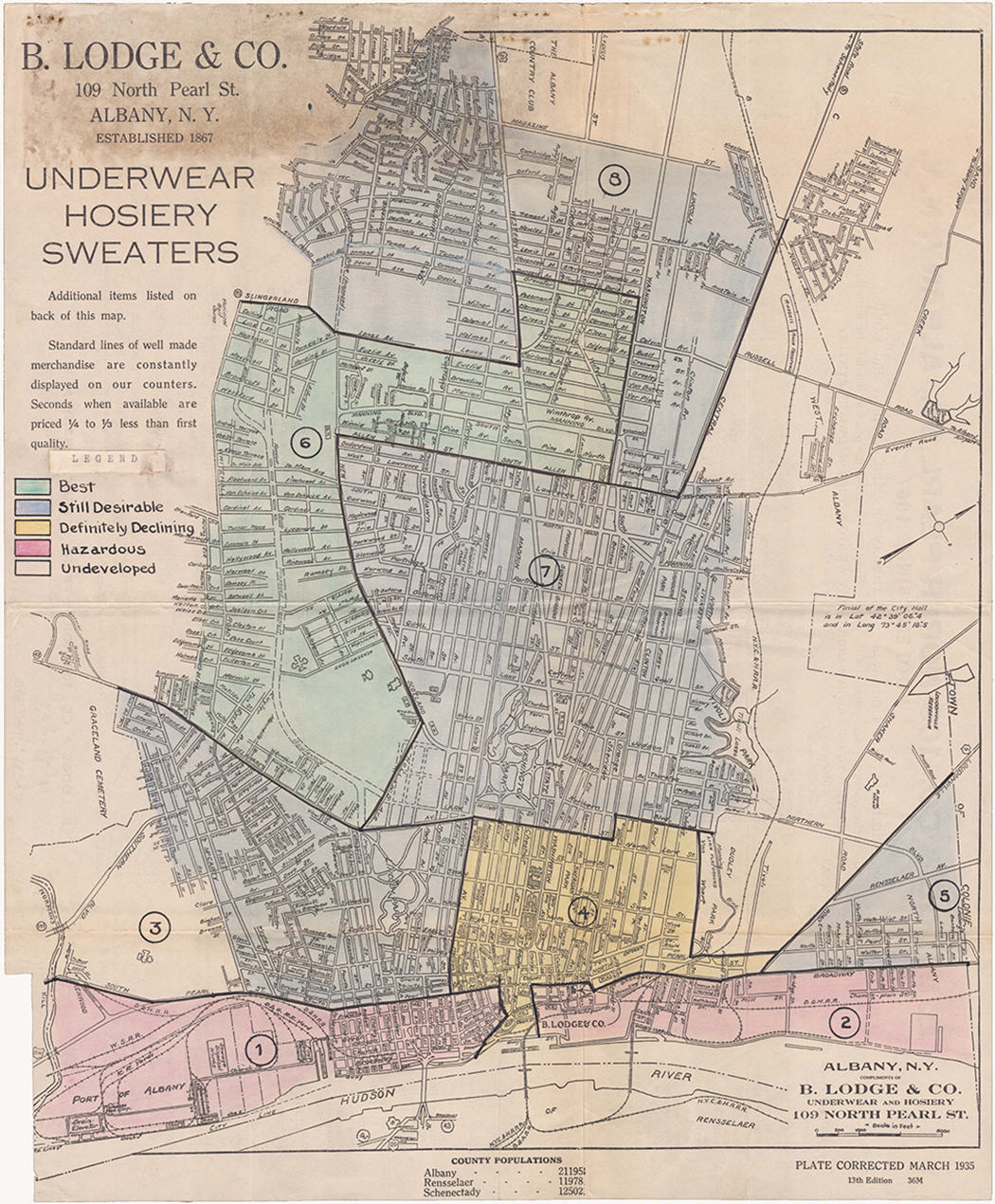
Early draft of a Home Owners’ Loan Corporation mortgage security map for Albany, New York, using a map from a local department store that presumably best fit the geographic scope and scale desired. Courtesy of National Archives II (College Park, MD).
Making copies of the security maps was quite a laborious process. Field agents or their assistants had to label the base maps, trace the security areas onto them in India ink, and cross-hatch areas by hand, a task that one agent noted “requires a good deal of time.” Reprographic technology at the time meant photographing the target image and then projecting it onto photosensitive paper in order to make uncolored copies.
110
Agents typically colored a master copy by hand, sometimes roughly in colored pencil or crayon; HOLC staff then used this to make additional copies, with each requiring on average five days to a week’s worth of work for large cities, with watercolors used for the first-generation maps (

1936 version of Cleveland’s security map by Field Agent Clifford C. Boyd, showing execution in India ink and watercolors by hand. Note also the rating of nonresidential areas, crosshatching not yet being used at this point. Courtesy of National Archives II.
An undercurrent of anxiety about expenses and an imperative to economize typified the MRD’s first year of operations. The base maps and photoreproduction could be particularly expensive, with some of the individual maps costing the equivalent of $60 today; the Los Angeles survey’s maps, to the field agent’s consternation, threatened to surpass the allotted budget maximum of $200, over $3,700 in today’s dollars. 113 Secretarial understaffing impacted the Washington office as much as agents in the field, with Fergus once berating even his favorite Boyd for a poorly-typed report that caused an “undue burden” when it had to be retyped. 114 Another field agent made a point to return early from a trip instead of overnighting during Good Friday because “it will prove less expensive to the Corporation,” while others economized by covering their assistants’ travel expenses out of their own pocket, making use of local WPA workers at no cost to HOLC, or even conscripting their own wives to assist in the work. 115
Major Questions and Future Directions
The initial consensus after Kenneth Jackson’s pioneering work was the primacy of racial considerations in New Deal housing policy. A related assumption held that HOLC shared the maps widely with other government agencies like the Federal Housing Administration (FHA) and presumably with private industry, making the agency culpable for the diffusion of redlining as standard industry practice into the 1960s and beyond. Notably, Amy Hillier challenged this premise nearly two decades ago. But without the General Administrative Correspondence, most scholars have merely speculated about the ways in which racial considerations informed HOLC’s work, how widely the security maps were shared, and how they were used. These records can help resolve longstanding debates and point not only toward a more complete and nuanced understanding, but also suggest some directions future scholarship might take.
Some of the evidence fits with established notions concerning HOLC’s views on race. Not surprisingly, the MRD listed population “trends” including race as topics to be covered in the earliest City Survey outlines and referenced the security maps’ racially- and ethnically-loaded “area descriptions” when discussing loans it held in various neighborhoods. 116 Behind-the-scenes comments are rather more explicit than anything previously seen, as when Field Agent Olson described Galveston’s black neighborhoods as “very trashy from the general residential picture.” Deriding it as “the only southern city I have found where whites intermingle with colored,” a situation that “depreciates the [mortgage] security,” Olson disapproved of the local practice of valuing “an exclusive negro section more highly than one containing a mixture.” 117 Olson and other agents’ explicit comments comport with our existing sense of HOLC’s nativist and racist biases. When faced with the challenge of how to evaluate ethnic settlements in El Paso and Oklahoma City, Olson turned to Fergus for advice. The boss’ answer was clear: “Any segregation or concentration of a particular nationality which would affect value or desirability should be shown.” 118
However, other evidence from these records indicates that we need to substantially revise our current interpretation of how HOLC theorized and applied its understandings of race. Scholars have long assumed field agents followed a clear and consistent set of guidelines when categorizing neighborhoods by security grades. Kenneth Jackson seemingly initiated this line of thinking when he confused an FHA individual block-rating procedure (to determine eligibility for its insurance) as the means by which HOLC designated its so-called security areas. 119 Subsequent researchers similarly assumed the grades had some empirical basis. For example, Kristen Crossney and David Bartelt posited that HOLC must have compiled the necessary data from loan applications in its rescue phase, even while admitting their hypothesis had little basis. 120 Amy Hillier was the first to suspect that HOLC’s process involved some degree of arbitrariness when she discovered significant discrepancies among three versions of Philadelphia’s map made in 1935, 1936, and 1937. However, she assumed these correlated to personnel changes rather than the lack of any standard methodology. 121 In his initial foray into the General Administrative Correspondence, Ocean Howell discovered scant consistency among West Coast cities in how Mexican American occupancy was evaluated. Because the same field agent had overseen all the surveys, Howell concluded that local lending norms and practices picked up from local consultations explained the discrepancy. 122 But no one would have predicted that grades might derive from one field agent’s belief that no more than 10-15 percent of any city’s neighborhoods should be rated “A” (green) in the interests of maintaining high “standards.” 123 In actuality, ideas about race in the mapmaking process were idiosyncratic, arbitrary, and variable rather than systematic.
Perhaps most strikingly, the MRD’s abjectly racist decision to rate essentially all African American neighborhoods as “D” (red), and thus “hazardous” for lending, does not appear to have been foreordained. At the outset of the City Survey, African American neighborhoods were supposed to be graded “F,” something of an asterisk (

Early draft of the security map for Birmingham (1936?), likely by Field Agent Alec Morgan, with “Negro” areas as a fifth security category colored in grey pencil. Courtesy of National Archives II.
The MRD’s goal of imposing a consistent national risk rating standard taking race into account sometimes conflicted with its desire to rely on local informants. In Savannah, Georgia, this produced the unlikeliest imaginable result: an “A” rated (green) African American neighborhood. While Field Agent Morgan felt this section “would have been better if colored in the blue instead of the green,” local realtors had insisted that “from a negro standpoint this was the best property in Savannah.” While Morgan considered such realtors “not what I would call aggressively active and up to date in their thinking,” he nonetheless deferred to their rating—as did Fergus. The green rating stood. 127 Even Fergus’s most-trusted C. C. Boyd was troubled by the implications of imputing creditworthiness to areas based on their demographic composition, although he was likely more concerned for white ethnic groups than African Americans. “The more I have thought about marking areas on these maps and then designating the nationalities with the assumption that these nationalities are detrimental to real estate values,” Boyd confessed on one occasion, “the more I think we are playing with something that may kick back.” He “wonder[ed] if it would not be better to…leave it to the judgment of the user as to whether or not the population is a detriment.” 128 Particularly confounding was the MRD’s discovery that in a number of cities, HOLC mortgagors in “C” and “D” areas had a better record of repayment, which led one Washington staffer to admit “we are anxious to know whether or not this trend will be definitely established.” 129 HOLC was essentially trying to fit its theories about property values to a messy reality that did not necessarily conform to either their expectations or past lending practice.
In keeping with the overall improvisatory character of the City Survey’s first year, agents, staffers, and Fergus debated the project’s mapping methodology and worked out policy on the fly. Scholars like Ocean Howell have suspected that business districts and some areas inhabited by people of color were deliberately “no-lined” in anticipation of demolition for future transportation projects. 130 But here too, there is no evidence of any planning foresight, with commercial areas also initially assigned a color. Fergus’s subsequent decision to not grade loan security in these areas and instead demarcate them using cross-hatching came too late, in fact, for the earliest batch of security maps. In at least one case, a field agent reported “All of my Memphis maps were colored before I left there and I do not have any more maps with me, hence the business district will be colored [in].” 131 Furthermore, several field agents urged Fergus to increase the number of security map colors to five, with an intermediate grade added between “B” and “C.” Olson explained the rationale here: “One objection to the grade ‘declining’ is that it applies to so many sections wherein [white] working people live and in those sections many Building and Loan Associations make loans. They do not like to be known as making loans in declining areas.” 132 Ultimately Fergus conceded the point that “there are different grades [with]in our [security] areas” but limited the number of colors to four to avoid “undue confusion.” 133
Dissemination of the resulting security maps and other City Survey materials has been another major point of scholarly contention. Kenneth Jackson’s original claims have enjoyed widespread acceptance into the present day despite recent challenges. “Obviously,” Jackson asserted, “private banking institutions were privy to and influenced by the government’s Residential Security Maps,” citing a set of FHLBB questionnaires that suggested New Jersey savings and loan leaders were familiar with HOLC’s four-grade security schema. 134 Even if true, it does not automatically follow that persons consulted in the mapmaking process were given access to the finished product. 135 And it is another step altogether to follow Jackson’s assumption that HOLC circulated its security maps to the home finance industry. 136 At least some scholars have paid more attention to a circa 1942 memorandum on the City Survey operations filed with the finding aid to the FHLBB Records. That report sheds light on access protocols for the reports and maps and their respective distribution. Of the maps, it explicitly states, “Almost from the beginning of the Survey Program there was a constant demand for copies from that part of the public which was familiar with them.” To prevent this, distribution was strictly confined to select government circles. “None of these maps have ever been given to private interests,” the report emphasized further. 137 Kristin Crossney and David Bartelt in a 2005 article were the first to cite this source in concluding that HOLC did not share the City Survey maps with private industry. 138 However, their finding has gone largely unacknowledged. Howell later reverted to Jackson’s original assumption that private interests must have had access. HOLC’s stated confidentiality, he concluded, “appears to be a case where official policy bore little relation to actual practice.” 139
Despite the MRD’s reliance on local industry in gathering information, Fergus followed HOLC higher-ups’ instructions not to share copies of the finalized security maps. On several occasions, he overrode his field agents’ desires to do exactly that, acknowledging that it was “somewhat embarrassing” to have ask for information without any promise of sharing the result. In at least one instance, local informants took matters into their own hands, when a Waco, Texas realtor traced the security area boundaries from a map Olson had lent him onto a duplicate copy. “Naturally I could not insist that it be torn down because after all the grades of security represented the judgment of these men,” Olson pled in reporting the lapse. 140 The only exceptions to the no sharing rule were on several occasions when Fergus determined there was no other way to secure the cooperation of high-ranking officials already associated with FHLBB-related work. For example, he sent maps and report summaries to Massachusetts’ Bank Commissioner and a copy of the Detroit security map to the Receiver of that city’s First National Bank. 141
Releasing security maps beyond their original confidential designation within HOLC proved a tortured process. Initially, only the five FHLBB Members had access. This strict confidentiality caused difficulties for the field agents. Just months into the project, two different agents asked Fergus whether they could share City Survey findings, including the security maps, with Regional managers to entice their cooperation. Fergus authorized them to show materials and explain what they were doing, but could not secure permission for sharing final products. 142 Yet some agents remained insistent. The outspoken Olson argued, “[E]ach HOLC office makes full and free use of the map in assembling the information on HOLC loans. The map information, therefore, is not confidential and if agreeable to you I would like to make a map for each manager who requests it as a gesture of reciprocity for the service and cooperation given me.” 143 Field Agent Wheeler also pushed hard for sharing but used a different rationale: the risk of redundancy, which might doom the MRD to irrelevance. By sharing its security maps the MRD could “assure uniformity,” seeing as the Detroit Regional Office had recently begun purchasing maps for its servicing and property management operations. Fergus’s favorite C. C. Boyd similarly feared that the MRD’s laborious work was going unnoticed. “Unless this knowledge is passed on to the proper sources,” he wrote, “other departments of the Corporation are going to be doing a number of things we have already anticipated.” 144
By February 1936, Fergus had secured permission for a wider sharing of City Survey materials internally. Regional managers were first granted access to security maps, with the reports delayed until sensitive interview material or identifying information could be redacted. 145 Fergus, however, continued to exercise some control. He authorized the sharing of only two copies of each map under confidential terms. After a compromising incident in Atlanta, Fergus devised measures to avoid further breaches. 146 By May, a clearer policy had been set: six copies of each report and accompanying security maps were to be produced, with just two passed along to Regional and State HOLC managers respectively, but with any sensitive interview material removed. 147 In a “responsibility that we must ask the Field Agents to bear,” Fergus noted, they were to individually determine what constituted sensitive content for redaction. 148 Several agents grumbled about this requirement. Olson stated, “I find that interviews and information are more readily given if I assure my people that all information supplied is confidential. Therefore, in my opinion, the entire reports are confidential, and to strike any particular part of it might take out the meat from the whole report.” 149 Yet despite lingering concerns that some “dynamite” might accidentally “boomerang” back to negatively affect the MRD, the Regional and State offices received their copies in October 1936. 150 Incidentally, this was four months after the last of HOLC’s refinancing loans were closed.
Another foremost question has concerned the nature of the relationship between HOLC and FHA, and the extent to which they coordinated their racially jaundiced assessments of the US housing market. Jackson portrayed the two agencies as working in tandem with “a free interchange of information and ideas” yet admitted he was unable to prove that FHA “simply adopted as its own” HOLC’s security maps. 151 Other scholars have identified rivalry, cooperation, or a combination of both between the two agencies. 152 While evidence defining the precise nature and extent of HOLC and FHA’s relationship unfortunately remains scarce in the General Administrative Correspondence, it is nonetheless telling. Ernest M. Fisher, FHA’s Director of Economics and Statistics, reported in March 1936 that the two agencies were working out an arrangement for “the confidential exchange of information.” 153 Even before a formal sharing arrangement, MRD personnel were clearly aware of FHA’s research projects, with Fergus once reporting to Field Agent Wheeler, “I was over to the F.H.A. the other day and find that they have made a complete study of Detroit areas.” “[Y]ou can ascertain whether or not this map is there and if no, you could spend a very interesting hour with the Chief Underwriter in checking your map with theirs,” he suggested. 154 In a rare exception, Fergus disregarded strict confidentiality rules by honoring FHA Principal Housing Economist Homer Hoyt’s personal request for a copy of the Atlanta security map—“provided that Dr. Hoyt understood that this map was for his personal use and that he would keep the same confidential.” 155 Notwithstanding the rivalries that existed between HOLC and FHA, these tidbits indicate that there were a number of open lines of communication which included the former keeping the latter apprised of the City Survey’s methodology and results. Suggestively, the MRD had offices in the same building as FHA until its merger into the FHLBB’s Division of Research and Statistics necessitated a move in September 1936. And the circa 1942 report clearly states that FHA received three copies of the entire set of City Survey maps upon completion. 156
A persistent misconception, even among some scholars, is that HOLC used security maps to deny applicants access to its mortgage refinancing assistance. 157 To reiterate, the agency’s loan-making phase was 90 percent complete by the time MRD even initiated the City Survey in September 1935, and essentially complete by the time that Regional mangers were given access to the first batch of maps. While Jackson acknowledged that HOLC lent in areas it considered risky for mortgage investment, he left the impression that the agency was actively refinancing loans and making the security maps simultaneously. 158 Later scholars following Amy Hillier more carefully drew the timing distinction, with Ocean Howell concluding that “HOLC itself did not ‘redline,’ at least not in the original sense of the term.” 159 Of course, this returns us to the initial question: if not for loan denials, then for what purposes did HOLC create the security maps? Here again, the General Administrative Correspondence holds some answers.
HOLC’s first use for the security maps was surprisingly mundane: mapping where it had made its refinancing loans in order to anticipate foreclosure volume and facilitate loan servicing. The MRD’s organizers had appreciated this particular utility of the City Survey project from the outset. They notified HOLC’s Assistant General Manager in Charge of Loan Service of the unit’s existence months before the formation of an actual Property Management Division in January 1936. Early correspondence to Regional Managers requesting logistical support stated field agents would be gathering “statistical information which obviously will be of great value to you in connection with the property management problems with which you will shortly be faced.” 160 As noted, Regional offices were in the process of downsizing at the time, so some managers predictably questioned whether the undertaking was “worth the effort.” 161 Therefore HOLC higher-ups sent follow-up letters specifying “We are particularly interested in the maps which they [field agents] are developing, showing the distribution of current and delinquent loans” and requesting “the assistance of your Appraisal and Loan Service Divisions.” 162
The tedious process of allocating the loans to the maps varied depending on field agents’ different work plans, access to clerical labor, and desired level of granularity. For each city, Fergus initially sought a simple tally of the total loans in each of the four security grade categories, a process that yielded the revelation that the best record of repayment was not always in the most “secure” lending areas. 163 What was involved, Field Agent Olson explained, was “running off cards by addressograph, stacking them by streets in numerical order and then spotting them upon a map,” which in the case of a mid-sized city like Dallas required “a great deal of work by several persons.” 164 An operator would first use the address printing machine to make cards for each loan in the district at a rate of about 1,000 per hour. These then had to be sorted manually by city and security grade before identifying the addresses on the map. Sometimes the District Appraiser’s staff did the work. Field Agent Morgan, who utilized this procedure for Savannah, quickly realized it was “not too much more trouble” to keep track of loans by individual security areas. “Therefore, my map will show not only the total number of loans made in each one of the four classifications of the city,” he reported back to Fergus with satisfaction, but also “the number of loans made in each individual red, yellow, blue and green section of the city.” 165 Other agents favored different approaches. Boyd tasked a small team of workers with mapping the actual locations of all HOLC loans onto security maps for several Ohio cities. “It requires tremendous detail to do all this,” he fretted. 166 Fergus’ subsequent request that all agents provide loan counts for the individual security areas as well as citywide totals by security grade meant that some had to redo their work. 167
Categorizing delinquent loans on maps was even more challenging and burdensome. Early on in the project, Olson claimed: “To show the delinquencies in the several parts of a city could only be done by the concerted efforts of a huge staff of experts, statisticians, etc. With payments coming in every hour of the day and with the arrangement of ledgers alphabetically it would be an almost impossible task.” Part of the difficulty came from HOLC managers’ delay in finalizing a definition of “delinquent” as 90 days or more past due. 168 Meanwhile, the Regional offices continued their foot-dragging despite entreaties from Washington. 169 While a number of the field agents experienced difficulties, Olson faced perhaps the most resistance in gathering delinquency totals from the Dallas Regional Office. His inquiries motivated the Regional Manager to complain to one of HOLC’s Assistant General Managers: “I simply do not feel there is a sincere appreciation of the difficulties involved in meeting his request, and I am calling it to your attention in order that you may [better] advise us as to your wishes.” 170 As a result of Olson’s experience, Fergus eventually gave up on obtaining delinquency totals from that office, and by early 1936 he abandoned the effort for the other regions as well. By that March, Fergus ceased even requesting loan numbers for security areas or totals by security grade. 171
However, one field agent did persist in following through, thereby demonstrating the enormity of the task. Fergus was eager to demonstrate the MRD’s relevance to other HOLC administrative units, and details on the locations of loans and delinquencies was particularly useful information. As recognized from early on, such data could “be put to practical use by a Loan Servicing Supervisor who is trying to concentrate on his most delinquent loans, as he would then know by exact areas where his worst situation existed.” 172 The same month that Fergus discontinued the effort, Field Agent Wheeler had gathered a month’s worth of loan stubs for the Detroit district and succeeded in convincing both the Regional and State managers that it would be worthwhile to map all 65,000 of that city’s HOLC loans by delinquency status. 173 Because no personnel in these offices were available, he arranged to employ some two dozen workers from the National Youth Administration and the local welfare office. With his operation up and running, Wheeler reported back that local administrative personnel, especially in servicing, were “anxiously awaiting the results of this breakdown,” with the intention of revising their procedures as a result. Wheeler hoped such information on loans could be used to organize loan checkups on a more efficient, geographical basis rather than randomly. “That way, each man will then be contacting people more nearly in the same social strata and perhaps more similar to each other,” he additionally noted. 174 Three months later, with the work complete, Wheeler confessed he was “sorry I ever took it on as it has been a monstrous job.” As a result, loans in Detroit by the end of 1936 were being serviced in a more logical fashion, right down to the individual security area, and HOLC’s Chicago offices were attempting to rationalize their own servicing along similar lines. 175
None of the previous discussion is to dispute that HOLC embodied the racist assumptions broadly characteristic of the real estate and home finance industry at the time. Indeed, it recruited its personnel from those sectors, and its policies were shaped by academic theories and professional practices premised on the assumption that African Americans and other racial minorities could only exert a negative influence on property values. 176 Even though black applicants received refinancing loans in rough proportion to their overall share of the country’s homeownership base, HOLC lending policies reinforced rather than challenged racial segregation. 177 Racist and otherwise bigoted remarks can be found throughout HOLC’s General Administrative Correspondence—yet none of this changes the fact that HOLC did not use the City Survey’s now-infamous security maps to deny its mortgage loans. This is because the project was initiated after its refinancing phase was essentially complete; Regional and State offices were not even authorized to receive copies of the maps until after practically all the loans were closed. And while the project relied on information from individuals in private industry, strict confidentiality guidelines ensured that they never gained access to the finished product, although the FHA definitely did. 178 Crucially, the new evidence cited here almost certainly confirms Jackson’s original contention that HOLC’s maps factored into the FHA’s own mapmaking process and quite plausibly that agency’s racially-informed denial of access to its mortgage guarantees.
Additionally, these new findings do not preclude the possibility that HOLC used the City Survey maps for discriminatory purposes once they were available—nor even that the agency would have used them to deny its refinancing loans if they had been ready during the rescue phase. Field Agent Olson once affirmed, “I think we have thought of maps in that connection” in response to a realtor’s suggestion that they could be used to determine location-based eligibility for mortgages; as noted, the use of maps for loan evaluation purposes was becoming standard practice in private industry at the time.
179
Furthermore, HOLC could have used the security maps in a racially discriminatory way that seldom comes to mind: deciding who was eligible to purchase liquidated properties through foreclosure.
180
An early indication along these lines came in a Deputy Assistant General Manager’s observation that “the maps and data show the trend of residential sections, volume of home construction, and many other items of great value to those employees in Regional Offices who must take action on matters affecting decisions on property sales, foreclosures, etc.”
181
While liquidation dragged on for many years beyond the scope of the General Administrative Correspondence microfilm that ends in 1936, other evidence makes clear that HOLC specifically designated properties it deemed appropriate for “colored” purchase, presumably in existing black neighborhoods (

Marketing card for a Home Owners’ Loan Corporation–owned property acquired through foreclosure, 1939, flagged for sale to African American buyers. Courtesy of Atlanta History Center.
In the ongoing effort to explain the racist record of New Deal housing agencies like HOLC, scholars would do well to continue exploring dimensions besides the notorious residential security maps. With the new information presented here about the first year of City Survey operations, we are in a better position to scrutinize HOLC’s discriminatory practices after 1936, an interval that has gone virtually uninvestigated to date. Later episodes are begging for researchers’ attention. For example, HOLC’s controversial program during World War II of “converting” its remaining properties to multifamily occupancy to help meet the wartime housing shortage appears to have been administered with regard to existing racial settlement patterns. 184 Understanding the origins of HOLC’s MRD and its City Survey, and particularly how underfunded and improvised the initiative originally was, hopefully will encourage future scholars to explore the project’s later phases and HOLC’s longer timespan more generally. HOLC would go on to resurvey more than twenty cities from 1938 until the project’s discontinuation at the end of 1940. But whatever the City Survey subsequently became, HOLC at the end of 1936 was in no position whatsoever to reshape the US housing market in the ways many have so often imagined. Near the end of the survey’s first year, one field agent felt “one of the biggest tasks is to get the operating heads of the Corporation to make use of the work which we are doing”—after learning that no one had yet asked to use the project’s reports and security maps now on file at the San Francisco Regional office. 185 Just the week before, Fergus had penned a draft memorandum for all Regional offices stating “we are anxious to get any suggestions on additional types of information which experience has shown would be valuable in our operation.” 186 For anyone supposing that the City Survey was a means whereby HOLC simply designed racial inequity into American cities, these long-overlooked documents make clear that the reality was considerably more complicated.
Footnotes
Acknowledgments
Thanks are owed to Daniel Amsterdam, Colin Gordon, Allen Hyde, J. Mark Souther, and the anonymous reviewers at the Journal of Planning History for their generous feedback on previous drafts, and particular gratitude to Catherine Conner for her insights and peerless editing assistance.
Declaration of Conflicting Interests
The author declared no potential conflicts of interest with respect to the research, authorship, and/or publication of this article.
Funding
The author received no financial support for the research, authorship, and/or publication of this article.
