
Abstract
In the context of a military dictatorship based on socialist ideology, Villa El Salvador emerged in 1971 in the south of Lima due to an internal migration process that began thirty years earlier and a collective effort by the community to achieve self-governance, which was facilitated by a modular urban structure. This urban phenomenon has not yet received the necessary reflection to understand the processes shaping its layout. Herein, the degree to which Villa El Salvador represents a contemporary blend of two urban traditions is critically explored, integrating perspectives from Western and Andean urbanism.
Keywords
Introduction
Peru, much like other Latin American countries, is
Lima continued its growth following the orthogonal layout until the nineteenth century, adapting to pre-Hispanic roads and water
Within this context, Villa El Salvador emerged to the south of Lima in 1971 as an urban proposal that acquired the category of “Villa” according to the Peruvian urban planning regulations in force at the time, in which cities and settlements were categorized according to population and size.
2
Thanks to self-management efforts made by a large migrant population, it was possible to secure suitable terrain from the military government to establish a new
This study closely examines the case of Villa El Salvador as a contemporary miscegenation, blending Western urbanistic heritage, represented by the formal city initiated from the colonial checkerboard layout, with the Andean legacy of urban settlements based on modular repetition, conceived according to their worldview and productive social structure to accommodate communal relationships and activities beyond housing.
Most of the existing studies made on Villa El Salvador tend to focus either on its sociological and
Methodology
The employed methodology centered on first-hand information gathered through on-site visits to Villa El Salvador and the conducting
The field visits included interviews with former community leaders actively involved in the founding and consolidation of the district. In addition, insights into the fundamentals guiding the design of Villa El Salvador were gathered through interviews with the project’s urban planner.
In the subsequent phase, a comprehensive review of literature and maps was undertaken to elucidate the characteristics of reticular urbanism in the pre-Hispanic world. This focused primarily on planned settlements characterized by orthogonal and modular structures. The Western perspective, spanning from the Hippodamian plan to Hispanic American cities, was considered. Major expansion projects from the nineteenth and twentieth centuries, grounded in the rationale of reticular continuity, were also incorporated into this study.
The literature study helped determine the theoretical foundations for assessing the urban grid and establishing evaluation parameters to assess Western and Andean contributions to its organization. The analytical parameters focused on patterns of repetition and modular design at the urban scale.
Based on the insights derived from this literature review and case analysis, a theoretical discussion was developed to contemplate Villa El Salvador’s significance as a benchmark case study, shedding light on the amalgamation of both reticular and modular urban heritages.
Repetition Patterns and Modular Design
The concept of modular design at the urban level has not been extensively explored in theoretical terms. Nevertheless, it is feasible to outline general guidelines or fundamental criteria through a comprehensive conceptual review. In the context of this study, the dictionary of the Royal Spanish Academy provides two relevant definitions of the term “module” 11 :
1. Dimension. Commonly considered as a unit of measurement, and, more broadly, anything that functions as a standard or rule. This definition denotes an established order rooted in the repetition of a unit of minimal dimension.
2. A piece or a set of pieces repeated in the construction of any type to simplify, regularize, and economize the process. This definition relates to a minimum and replicable construction unit, allowing the conceptual analysis to extend to the scope of repetition of this unit.
Repetition patterns can be seen as a design approach that concentrates on duplicating a structural or functional module. Due to their inherent formal and/or constructive traits, these modules facilitate the formulation of growth fundamentals, imparting a systemic quality to the whole. 12 However, these growth fundamentals cannot originate from a central hierarchical model or structure. 13 On the contrary, the regulation of the system depends on the adaptability and reconfigurability of each module.
In the broader context of repetitive composition as classified by Arnedo, 14 two main strategies emerge: regular repetition and irregular repetition. For an urban context and the intentions of this analysis, a regular and complex repetition strategy will be employed. This approach entails the spatial combination of elements that completely forfeit their autonomy and individual identification to seamlessly integrate into a unified whole.
Now, within the strategy of regular and complex repetition, two compositional elements will aid the analysis conducted in this study: grids, defined as extensive systems composed of the constant combination of one or more geometries, and plots, accepted as extensive systems configured by the repetition of functional units that already have an organized internal arrangement. These units connect to other similar units through complex projective relationships (Figure 1).
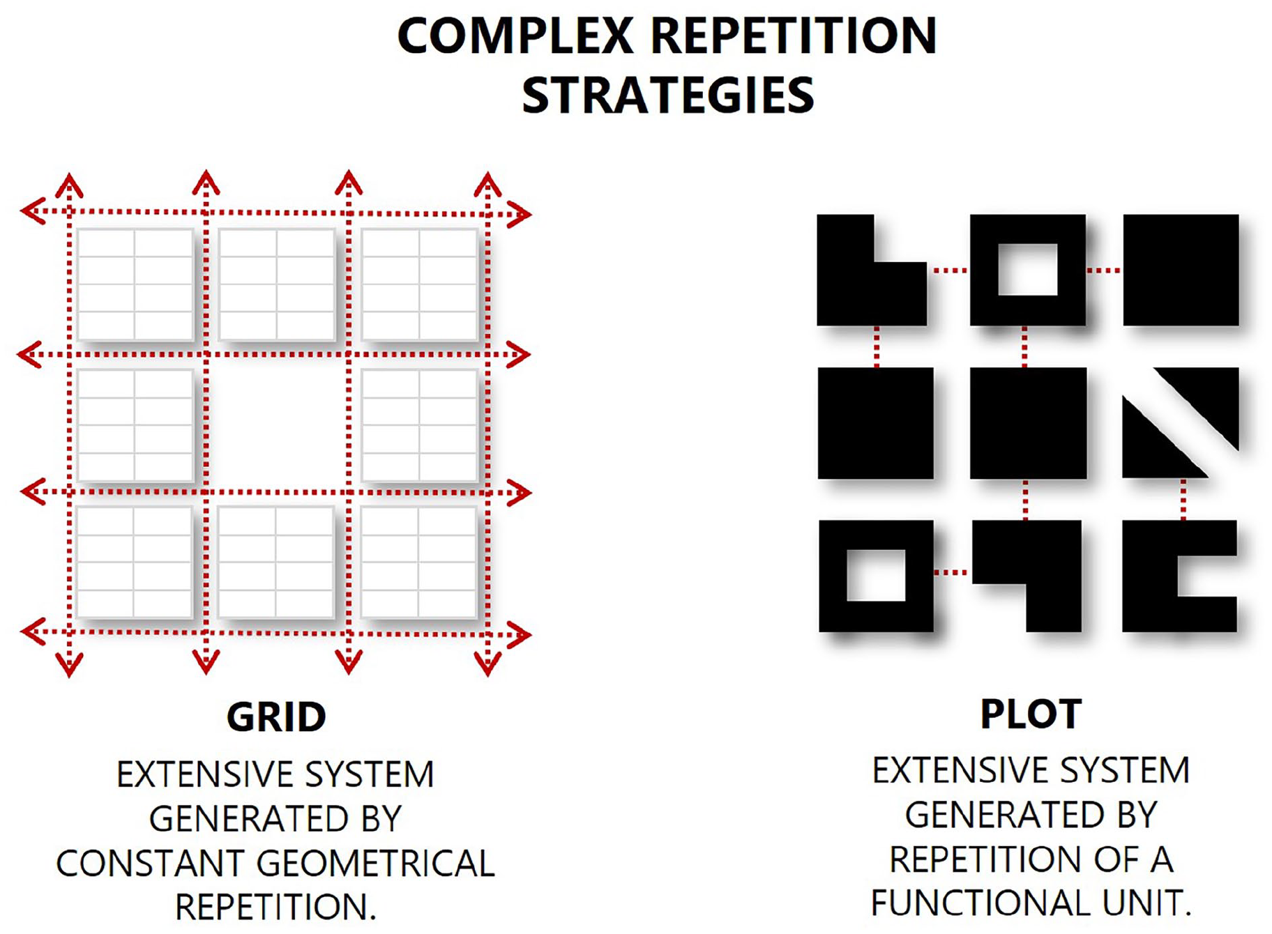
Graphic synthesis and approximation of the urban context of the meshes and grids as strategies of complex and regular repetition. The mesh originates from a pattern of geometric repetition, and the grid originates from the repetition of functional units that have internal functionality.
While this classification of repetitive design strategies is oriented
Andean Urban Heritage
This study will explore the pre-Hispanic urban heritage in Peru, particularly its impact on modular urban design. For these purposes, a difference in the approach to analyzing and understanding pre-Hispanic architecture and urbanism should be delineated. Makowski 17 underscores the necessity of avoiding an analysis of the pre-Hispanic-built environment from a Western perspective that seeks anthropocentric principles for facilitating the activities and social relationships of a population. Instead, this author contends that, in the pre-Hispanic context and under a Western approach, it may be characterized as an “anti-urban Andean system.”
Without deviating from the study’s purpose, which is not an exhaustive analysis of pre-Hispanic urbanism in Latin America, it is pertinent to summarize and highlight certain features outlined by Makowski.
18
As opposed to the anthropocentric approach of Western urbanism, what is known as pre-Hispanic urbanism was guided by a cosmocentric perspective, and not just in the Andean environment. Therefore, the arrangement and coordination of structures on the landscape were conceived
Regarding the principle of planned and modular design, the viewpoints of Williams 19 and Canziani 20 propose the existence of modular design in the form of large rectangular enclosures or Kanchas constructed in a single phase, thus following predetermined schemes. This occurrence unfolds within the context of cultural unification across the Andean region, 21 emerging under the dominance and expansion of the Wari Empire in the central Andes during the Middle Horizon period (~600–1,000 CE). This development is part of a broader strategy aimed at consolidating successive advances in territorial control and organization.
This approach to urban planning continued to influence later cultures and reached a more sophisticated level during the second stage of the Inca period or the Late Horizon (1438–1532). As a result, the initial dominance of religion expressed in public ceremonial architecture gradually evolved toward urban developments associated with an efficient political-administrative system. This system facilitated the expansion of the productive base through public works, leading to a socially redistributive economy. Despite this shift, military resources persisted as a notable component of the exercised power. 22
Under this paradigm shift, the Wari Empire solidified its position, employing urban planning to systematize and enhance efficiency in occupying and integrating new territories, particularly where there were no pre-existing settlements. Hence, Wari urbanism emerges as a straightforward model featuring preconceived large rectangular enclosures with an orthogonal urban layout of narrow streets with high walls which results from the sequential repetition of a rectangular enclosure unit as stated by Makowski.
23
This rectangular enclosure unit represents a new stage in the evolution of
This enclosure unit maintains its central void and adjusts its architecture with perimeter buildings structured to serve various functional needs. These functions may include administrative roles (taxation, accumulation, redistribution, etc.), ceremonial purposes, productive activities, and residential areas. Here, the pre-Hispanic economic and productive system relied on communal work organized around the “Ayllu,” (a Quechua term denoting the ancestral basic unit of pre-Hispanic Andean societies). The Ayllu signifies a social organization grounded in kinship, origins, and shared property ties, often linked to a specific territory
25
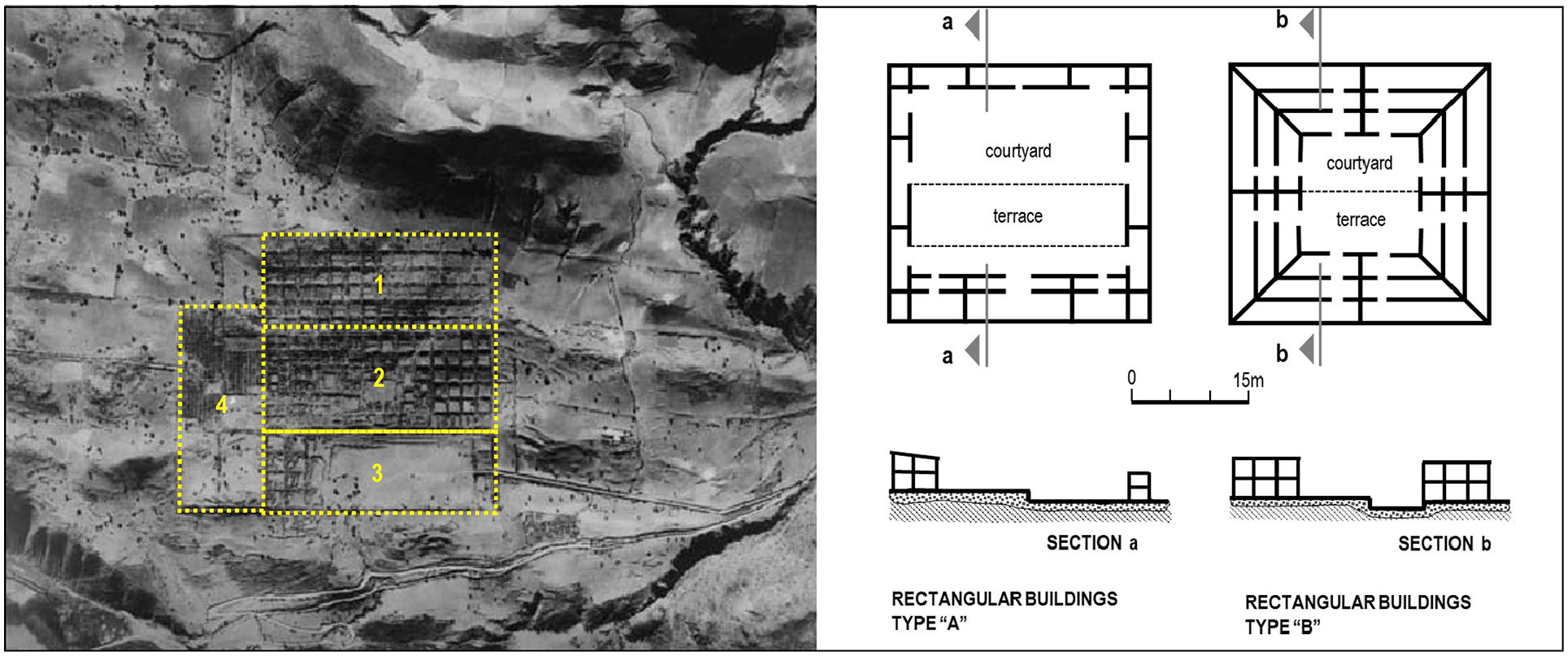
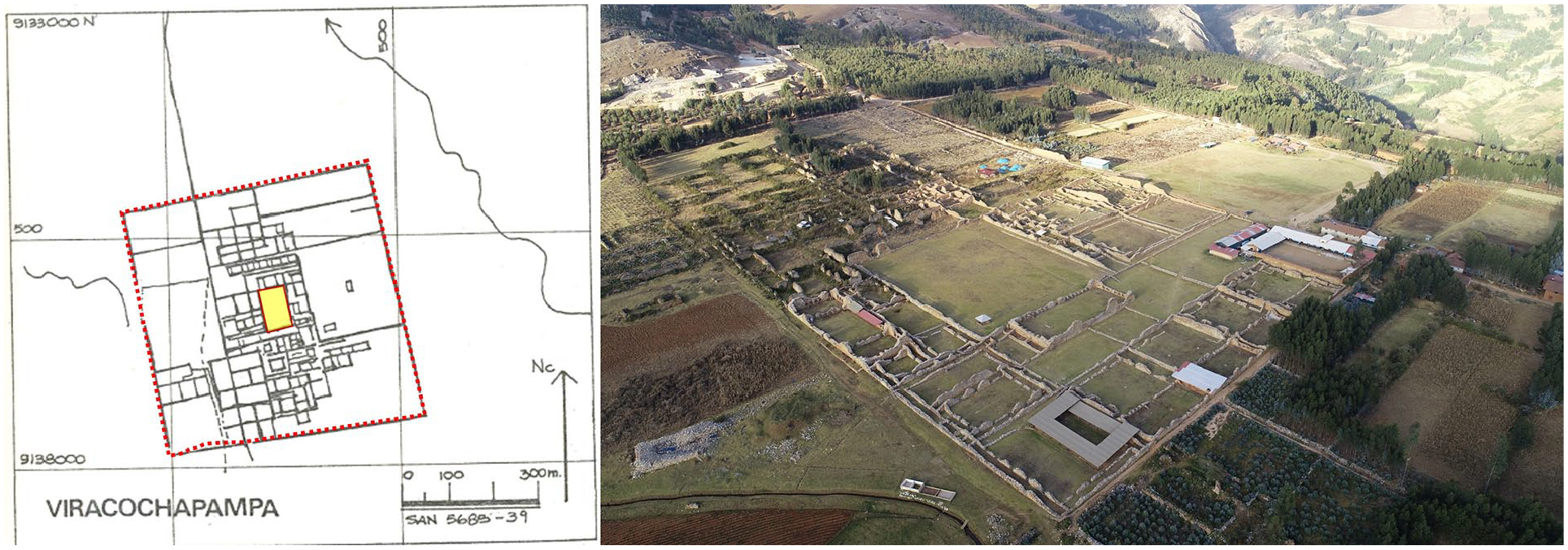
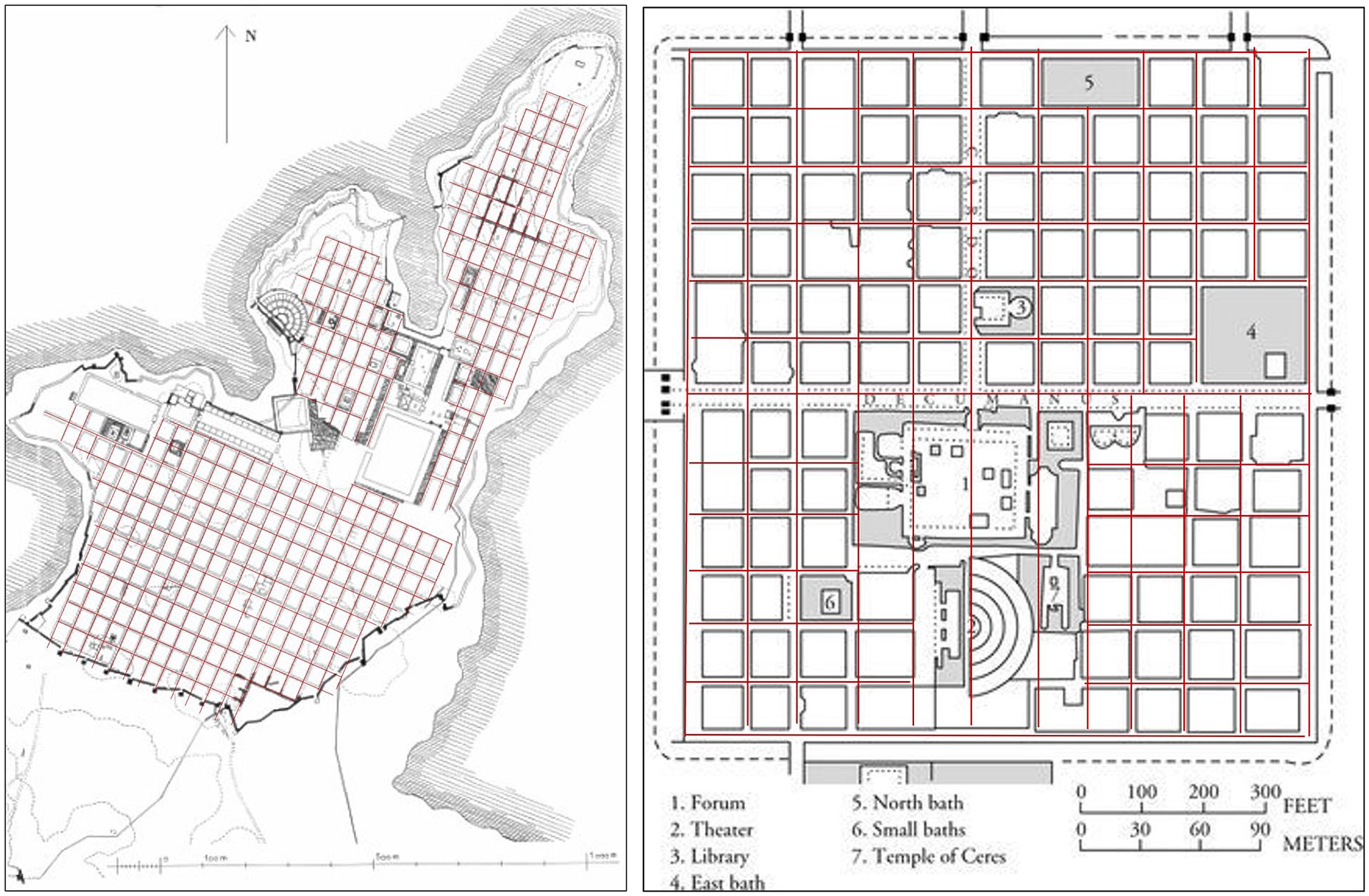
The rectangular enclosure unit, serving as an urban cell and fundamental architectural typology, was designed in various forms to host diverse communal activities that sustained the Ayllus, urban settlements, and, ultimately, the empire. Two of the most iconic examples from this period are likely the complexes of Pikillacta (Figure 2) and Viracochapampa (Figure 3). In both instances, an orthogonal urban pattern based on a modular scheme with a main kancha or courtyard is evident. This central space is enclosed by a square perimeter, dictating its urban framework in harmony with the terrain. Notably, Pikillacta demonstrates a clear sectorization into four primary zones. While specific data on the distinct functions of these four zones is lacking, it is conceivable to identify a storage zone (north), a region with rectangular enclosures (east), a central zone featuring heightened complexity and restricted access to enclosures (center), and a public zone distinguished by a spacious esplanade (west).
28
It must be clarified that the translation of the term Kancha from Quechua refers to an enclosed or fenced open space
Left: Aerial photography and sectorization of the Pikillacta complex in Cusco. Right: Two typologies of enclosures with central kancha found in the Pikillacta complex in Cusco.
Left: Plan of the Viracochapampa complex in La Libertad. Right: Aereal photograph of the Viracochapampa complex in La Libertad.
Concerning new settlements, Inca urbanism
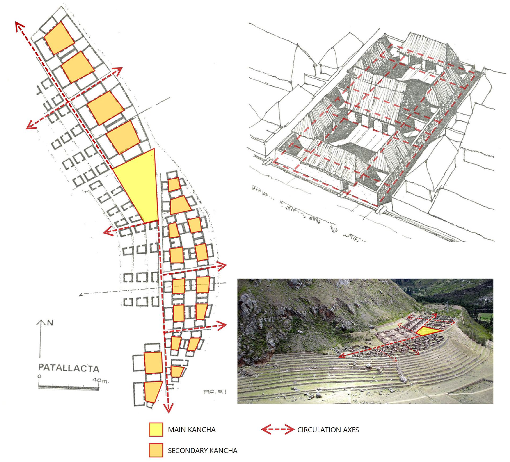
Modular structure in the Patallaqta Complex, Cusco.
Western Urban Heritage
The reticular layout concept in urban planning originated in
The use of the Hippodamian plan, with orthogonal road axes, continued in the Roman Empire. Initially employed for military purposes in Castrum or military camps, it later evolved into well-planned cities such as Timgad (100 CE). The deployment of organizing axes, known as Cardo and Decumanus, as main roads North-South and East-West oriented, respectively, generated reticular urbanism. At the intersection of these main roads, the agora was replaced by the forum, which serves as the main public space conformed mainly by public buildings for political, administrative, and commercial activities, along with temples.
Blocks resulting from the intersection of orthogonal road axes also exhibited variations between Hellenistic and Roman cases, as illustrated by Miletus and Timgad. In Miletus, the layout of orthogonal axes showed marked variations between square and rectangular blocks, delineating two large residential neighborhoods articulated by the agora and accompanied by a concentration of public buildings. In Timgad, the orthogonal reticular structure eventually developed into square blocks which
Evolution of the Hippodamic layout plan up to the Roman Castrum. Left: Variable grid layout in the city of Miletus (IV BCE). Right: Quadrangular grid layout in the city of Timgad (100 CE).
The exploration of reticular urban models persisted throughout the Middle Ages. The ideal city model crafted by Francesc Eiximenic in Book XII of the Crestiá (1386) amalgamated spiritual, governance, and material aspects. It incorporated lessons from the Roman Castrum experience, culminating in a refinement process and a quest for regularity initiated in earlier Spanish settlements.
37
Cases such as Eiximenic’s (Figure 5) exemplify the intention to plan urban space and achieve order by maintaining the regularity of a checkerboard or grid pattern. An important complementary development was
Renaissance theorists strongly advocated for the principle of regularity and the enhancement of the public square, motivated by defense considerations and the rectification of urban shortcomings. 39 Despite the prevalence of urban models with radial layouts, such as Filarete’s Sforzinda (Figure 6), which may have been conceived through a misinterpretation of Vitruvius’s writings on city orientation based on winds, 40 Exploration of the reticular urban model persisted, as demonstrated by the work of Pietro Cataneo (1510–1569).
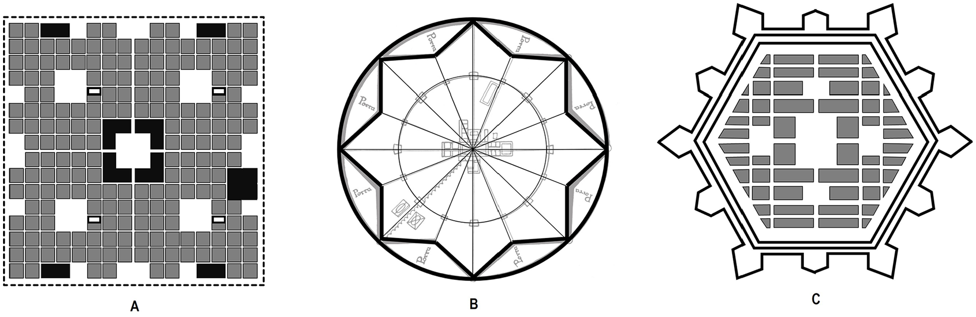
Three reticular models by medieval and Renaissance Theorists. (A) Eixemenic reticular model. (B) Radial grid model. Sforzinda by Filarete. (C) Pietro Cataneo’s reticular model.
While the New Laws of the Indies formalized the principles and regulations for the foundation of new urban areas through the ordinance of Philip II in 1573, this legislation marked the culmination of a process of application and refinement of the urban model that had already been employed in Hispanic America since the founding of cities such as Villa Rica de la Veracruz (1519), Mexico City (1521), or Lima (1535). In these cities, an evolution from an irregular reticular form to a grid of identical square blocks can be observed (Figure 7).
42
This consolidated the initial global idea of an irregular array of street axes into a regular grid model aimed
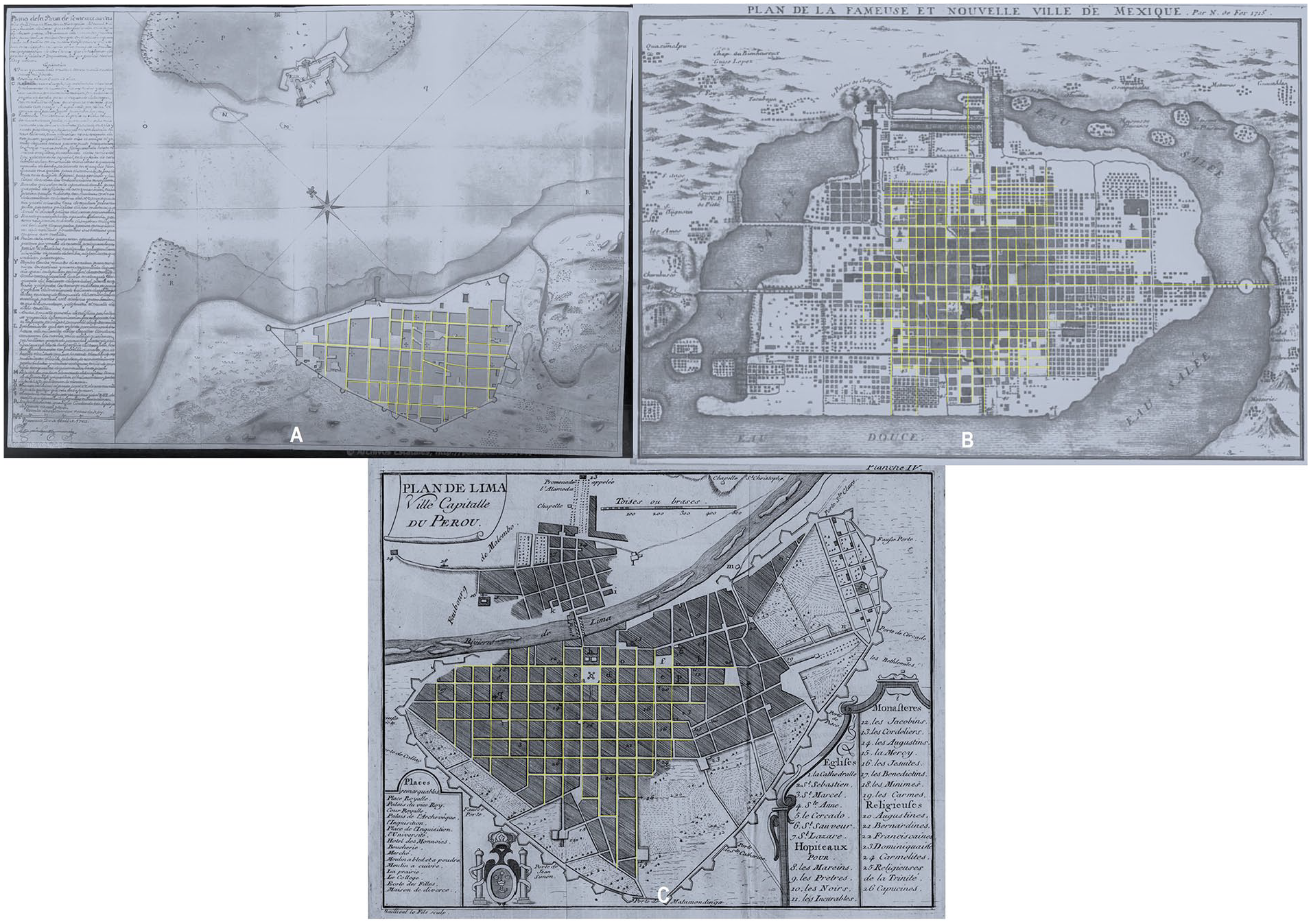
Evolution of the Hispanic reticular city. (A) Villa Rica de Vercaruz (1519) with an irregular layout. (B) Mexico City (1521) with an irregular layout. (C) City of Lima (1535) with a checkerboard layout of identical square blocks.
The gradual imposition of the grid in Hispanic American cities did not necessarily result from a reassessment of classical and medieval models but rather a response to the need
The tradition of orthogonal urban planning resurfaced in the nineteenth century with Spanish urban expansions in Madrid and Barcelona, which were led by Carlos María de Castro and Idelfonso Cerdá, respectively. This was a response to the intense demographic growth and industrialization experienced by Europe during that period. What sets Madrid and Barcelona apart from other urban expansion processes in Europe, as shown in Figure 8, is the almost radical rationalization and orthogonality of the new urban spaces. It evolved from its colonial and Greco-Roman predecessors into a remarkable rationalization of the secular historical experience in the construction of old town centers.
45
The objective was not only to build a hierarchical organization and widen the pedestrian-friendly thoroughfares and exchange spaces but also to generate a shift toward a new model of closed city blocks. Instead of accumulating plots, the aim was to provide continuity to the urban fabric through collective housing and a mix of uses, with exceptions for large buildings or public facilities. Especially in the expansions of Madrid and Barcelona, the classical, closed city block’s evolution, formed by the intersection of orthogonal axes, migrates into an improved block with a common public courtyard or garden. This new type of closed or
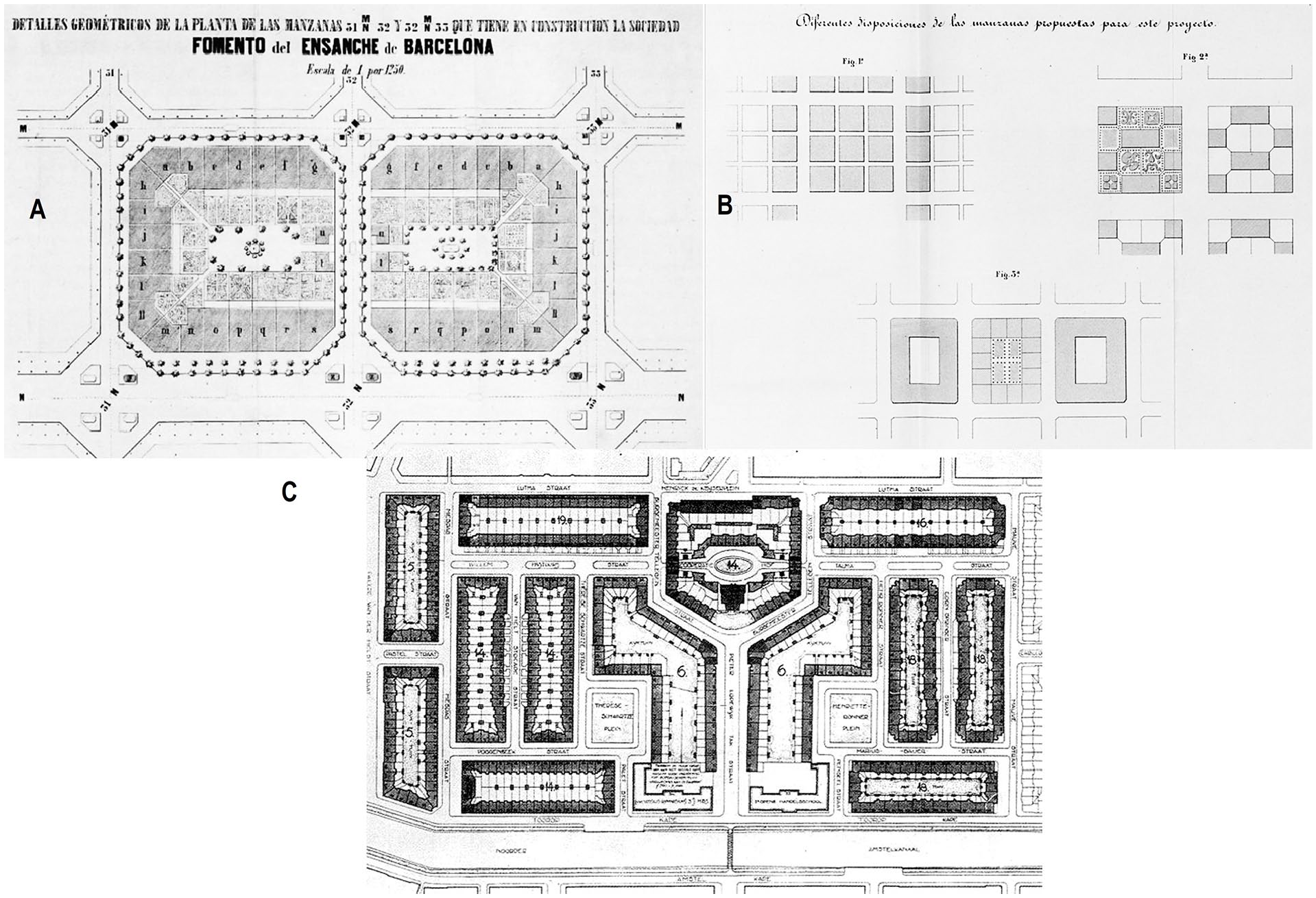
Evolution toward the closed and semiclosed blocks in the expansion projects of the nineteenth and twentieth centuries. (A) Details of the city block model from the Cerdá Plan in Barcelona (1860). (B) Details of the city block treatment from the Castro Plan in Madrid (1860). (C) Details of the city block treatment from the Plan Zuid in Amsterdam (1917).
In the early decades of the twentieth century, cities such as Amsterdam and Vienna addressed the need for affordable housing and tackled unsanitary urban conditions through a process of land expropriation, enabling new urban developments. In contrast to the disruptive models of modernism, these developments prioritized continuity with the historic city and the
This modernity, aiming to maintain the continuity of the classical urban profile through a reticular urban structure, stands in contrast to models such as Howard Ebenezer’s Garden City, Clarence Perry’s Neighborhood Unit, and the open-block designs originating from Le Corbusier’s Radiant City and other International Congresses of Modern Architecture—CIAM
In Peru, modernity became a process of hybridization or the convergence of cultural patterns that enriched and led to the emergence of new urban practices and customs.
48
The initial push for modernization occurred in the 1920s during the second government of President Leguía (1919–1930). This era witnessed the start of an early modernization process for the state and the city of Lima, which involved foreign investment, sanitation plans, and the development of extensive avenues. It also included the initial expansion aimed at connecting Lima with the port of Callao and the
A second wave began to emerge in the 1940s when the first alarm was raised about 63 percent of Lima’s population being of provincial origin and living under perilous conditions, as confirmed by the census conducted in 1940. Here, we must recognize that migration from rural to urban areas resulted from modernization efforts implemented in the preceding years in the coastal cities of Peru. Against this backdrop, the fields of architecture and urban planning departed from academicism and the imitation of colonial models, embracing the principles of the CIAM. For the first time, there was an alignment of urban requirements with social needs, 49 leading to the integration of the city with the initial expressions of mass housing. This transformation is evident in projects such as the Unidad Vecinal N°3, constructed between 1945 and 1949 and inspired by Perry’s model, or the Residencial Matute, built between 1952 and 1965, which leaned more toward Le Corbusier’s open-block model.
On the Western front, reticular urban design evolves from the continuous reformulation of historical reference models, from the grid layout to Hispanic American colonial cities. Perhaps in the reticular expansions with closed city blocks in Madrid and Barcelona as well as subsequent cases such as Amsterdam or Vienna, one can discuss modularity founded on a block that goes beyond the grid layout, transforming into a repeatable and adaptable architectural model accommodating mixed uses. This continuity arises from the necessity to rationalize land use, leading to urban models centered on collective housing, which in turn create public spaces emphasizing pedestrian interaction and coexistence. This coexistence is vividly experienced in public areas, facilitated by the presence of commerce and other activities accompanying housing, and in a more controlled and private manner in the inner courtyards of the blocks. Conversely, in Peru, the arrival of modernity, which was belated and in its early stages, triggered a considerable migration from rural areas to the major coastal cities. According to Shariff Kahatt, 50 this modernization phenomenon gave rise to a blend of mestizo cultural patterns (pre-Columbian and colonial) with strategies from the Anglo-American modernization of the twentieth century. Urban models adopted from the initial city expansions distanced themselves from the reticular urban model with square blocks that originated in Lima in 1535.
Villa El Salvador
Villa El Salvador emerges as a distinctive case in Lima’s urban development, serving as a planned alternative to the rampant and informal urban sprawl that began around 1940 and for its swift execution. Rooted in the ancient heritage of pre-Hispanic Andean culture and the basic unit of the Ayllu, 51 its urban structure operates on principles of communal work, reciprocity, and solidarity. Based on these principles, one can comprehend the urban structure and its connection to communal organization. According to Salvador Rueda, 52 the success of planning was grounded in the notion that public space, particularly the essence of the city, fostered social cohesion by expanding opportunities for interaction, exchanges, and communication. This laid the groundwork for constructing social capital, thereby enabling self-management and community achievements during the formative and consolidation years of Villa El Salvador.
From Occupation to Urban Project
The occupation of Villa El Salvador commenced with the occupation of private lands in the southern part of Lima. This occupation originated in the area known as La Parada, the Wholesale Market of Lima, and materialized in the southern part of Lima in 1971 on private lands located in the neighborhoods of San Borja, Monterrico, and Pamplona. 53
These lands were initially occupied by 200 families from different provinces within the country. This number increased to ~1,900 families, 54 prompting a violent police eviction attempt led by the current Minister of the Interior, which resulted in fatalities among the community leaders. The increase in families occurred due to negotiations with the government and the scale of the urban project attracted even more people interested in settling and starting new homes, finally reaching 7,000 families in the first stage of occupation at the new project.
A relevant aspect of the context in which this initial process of
The transfer of 7,000 families to a 2,500-hectare public property land located south of Lima in the area known as La Tablada de Lurín (Figure 9) was negotiated. According to Romero, 55 the land was chosen for its almost homogeneous topography and the absence of legal issues, as it was publicly owned and designated for urban expansion according to the Lima and Callao Metropolitan Development Plan (1967–1980).
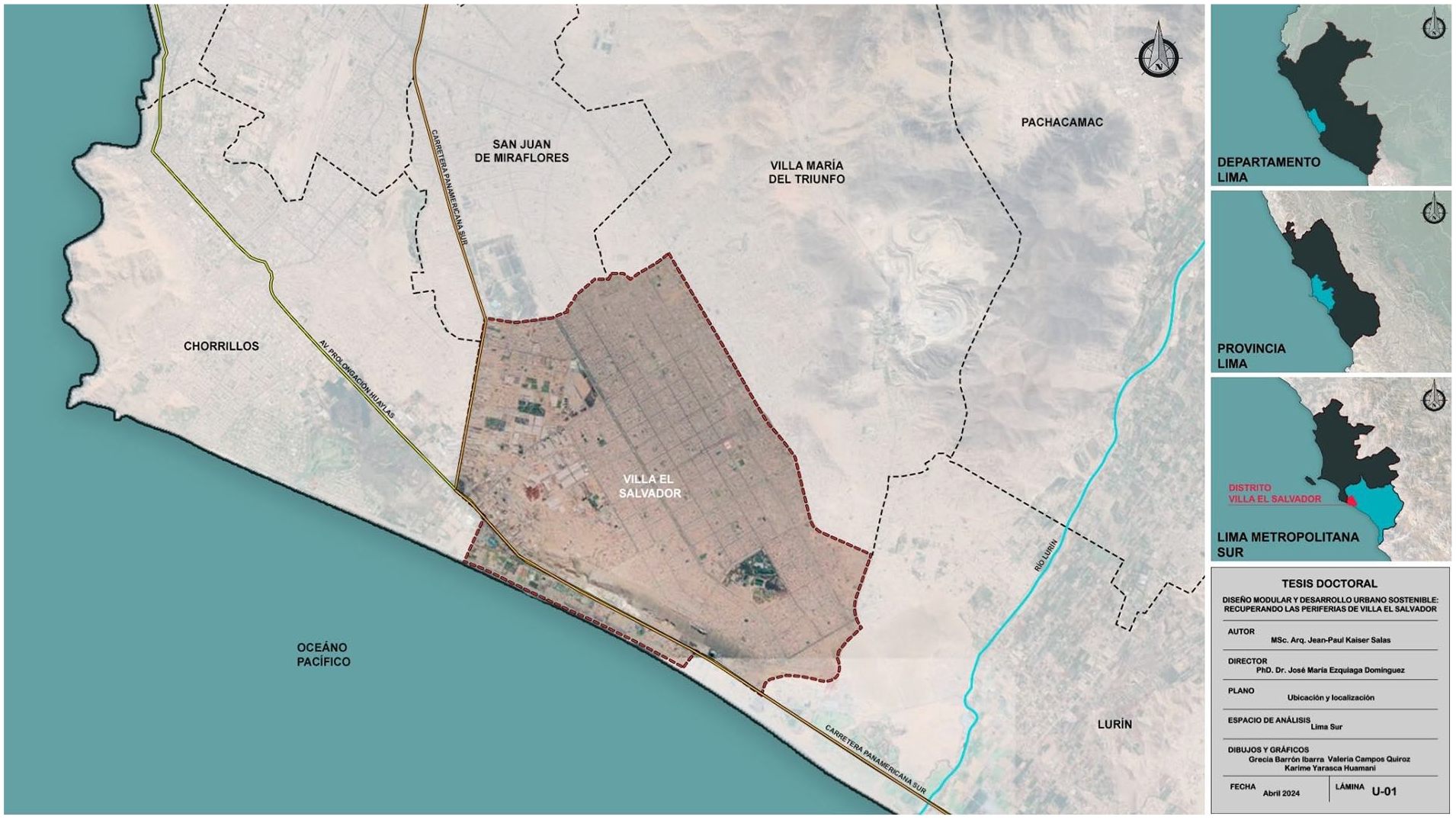
Location map of Villa El Salvador.
Urban Project and Social Organization
During negotiations with the military government, it was decided that the “Junta Nacional de la Vivienda”
A notable aspect of the urban project that led to the formation of Villa El Salvador was its genesis in the close interaction between the technical team and the local population. This engagement enabled the project’s author to address the most immediate needs of the population and comprehend the importance of reflecting and facilitating their social organization in the project. According to Romero, 56 the primary interlocutors in this process were community leaders. Drawing from these direct interactions as well as through participation in neighborhood meetings, the major concerns of the population were identified and integrated into the urban project.
The territorial model of Villa El Salvador (Figure 10) was structured around a
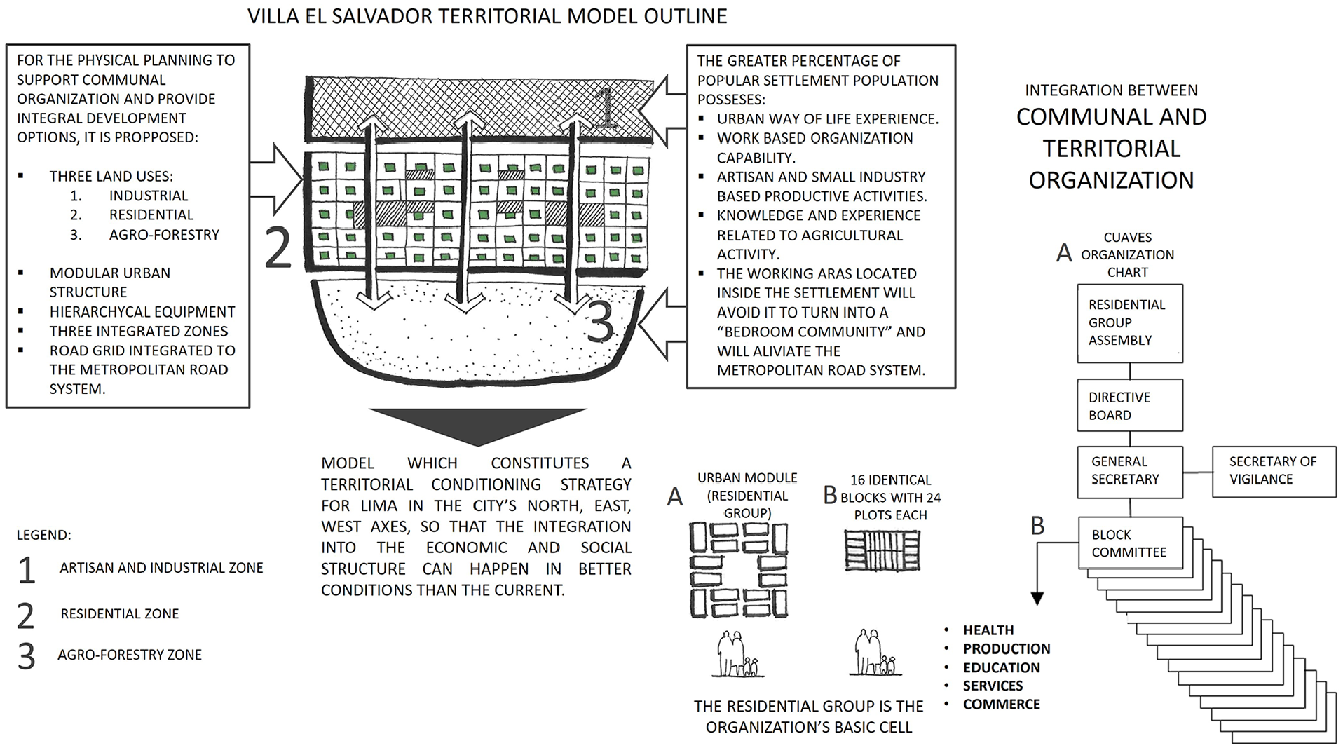
Territorial model of Villa El Salvador.
The primary objective of this project was to create a simple and adaptable urban structure conducive to the development of community organizations.
59
Following this principle, the layout of the residential area was conceived with a modular and flexible module applied throughout the designated territory (Figure 10). This residential module consisted of sixteen blocks, each containing twenty-four plots measuring 140 m2 (7.00 m × 20.00 m), along with a central public space that housed a park and communal facilities. The implementation of this modular urban structure facilitated the organization of Villa El Salvador’s residential area,
Certainly, from a technical perspective, preceding experiences served as valuable lessons for the subsequent realization of the Villa El Salvador project. Under the auspices of the National Housing Board, Romero authored urban developments in Pamplona Alta, Año Nuevo, and San Gabriel (1968, 1969, and 1970, respectively). These initiatives reflected a preliminary intent to structure urban land using evolving modular frameworks.
These early endeavors underscored the critical lesson that urban design should be closely tied to social capital, with urban planning serving as a facilitator for social organization. 65 While the heterogeneous modulation of these three urban models did not achieve the same effectiveness in facilitating community organization as Villa El Salvador, as reflected in the subsequent occupation of areas originally designated as public spaces, it revealed a trial-and-error process that allowed for the progressive refinement of urban modulation leading up to its culmination in 1971.
To facilitate the community organization of the population, the modular urban structure was

Territorial model application of Villa El Salvador.
It is important to note that within the residential group module of Villa El Salvador, the block constitutes the minimum construction unit. Similarly, within the four building types established by Ramón López de Lucio, 68 this unit adheres to a block model based on the self-construction of rows of self-built single-family homes. Moreover, the block serves as the minimum unit of communal organization within the territorial model of Villa El Salvador.
Analysis of Repetition Patterns
By conducting a morphological analysis and adapting the strategies of repetition theory (as reviewed at the beginning of this article), a process is outlined to identify the elements that construct patterns in each case and thus deduce the blending of Western reticular urbanism and pre-Hispanic urbanism traits throughout Villa El Salvador. Within the strategies of complex regular repetition, there are two major groups: grids and plots. According to both definitions, it is possible to assign them to each of the reviewed layout types.
Andean modular urbanism is identified with a plot structure because it is a system configured by the repetition of functional units with a specific internal organization corresponding to the rectangular enclosure as the basic unit of Andean modular urbanism. The hierarchy and spatial relationships between built enclosures, which correspond to the Ayllu as the fundamental unit of the Andean social structure, reflect the socioeconomic structure within pre-Hispanic planned urban centers, which were pioneered by the Wari culture and refined by the Inca culture. In contrast to Western urban heritage, Andean modular urbanism arises from the repetition and adaptation of a basic module whose primary objective is to contain specific activities. An important characteristic of Andean modular urbanism lies in its circulation passages, which are exclusively and dedicated to transfer and distribution functions. This function, as noted by Makowski,
69
Canziani,
70
and Hardoy
71
is restrictively related to spatial relationships according to the social and productive structure within the settlement as the streets don’t provide access to all the enclosures. This issue is addressed by Williams
72
stating the possibility of roof access to some enclosures. It’s important to state that the repetition of the functional zoning, the repetition of specific enclosure typologies and the restrictive character of the circulation layout,
In the case of Western reticular urbanism, the most prominent characteristic is the clear separation between public and private spaces, with the former concentrated predominantly, though not exclusively, on road axes. Hence, “the grid of streets and blocks defines a fundamental and extremely effective functional and legal binomial: the network of streets, squares, and avenues is of a public nature (domain and conservation), and the set of subdivided and built blocks is of a private nature.” 73
At the morphological level and within the reviewed repetition strategies, Western reticular urbanism is identified in the category of grids. This classification arises from its nature as a system that expands through the consistent combination of one or more geometries, particularly a rectangular grid. This grid forms the basis for the road structure and the constructed blocks, effectively delineating the boundaries between the public and private domains. In practical terms, shared community activities and various social, cultural, and commercial interactions typically occur along the roads, with residential and other private functions confined within the blocks created by the intersection of these road axes. In addition, while expansion projects observed in Madrid and Barcelona, along with their successors in Amsterdam and Vienna in the early twentieth century, showcase clear modularity through the repetition and adaptation of a preconceived block model aimed at standardizing the urban profile and adding continuity to the historical city, 74 the fundamental urban structure is perceived as a grid with its origin rooted in the reticular geometry of its road axes. In summary, the morphology of Western reticular urbanism is fundamentally rooted in the grid as its main repetition strategy.
It’s important to stress the fact that Andean Urbanism (or
The repetitive geometric pattern underlying the residential group in Villa El Salvador objectively facilitates the rational distribution of public spaces and urban amenities, adhering to the principles of efficiency and equity (Figure 12). Furthermore, this helps residents recognize and navigate their territory, whether at the block, residential group, or sector level. This characteristic aligns with the legibility principle in urban landscapes, 76 emphasizing the need for a coherent pattern for recognition and organization among different components. Moreover, this principle could be extended to create functional relationships and interdependence among residential units. This facilitates the generation of an urban and social network of dynamic collaboration at various scales, providing a comparative advantage over other cities or settlements lacking the urban planning characteristics of Villa El Salvador. Unlike Andean modular urbanism, the road axes at various hierarchies and scales in Villa El Salvador are not limited to the restricted function of circulation. On the contrary, they form a network of meeting spaces and unrestricted exchanges that complement and integrate the parks of residential units, ensuring the principles of autonomy and interconnection inherent in a modular system.
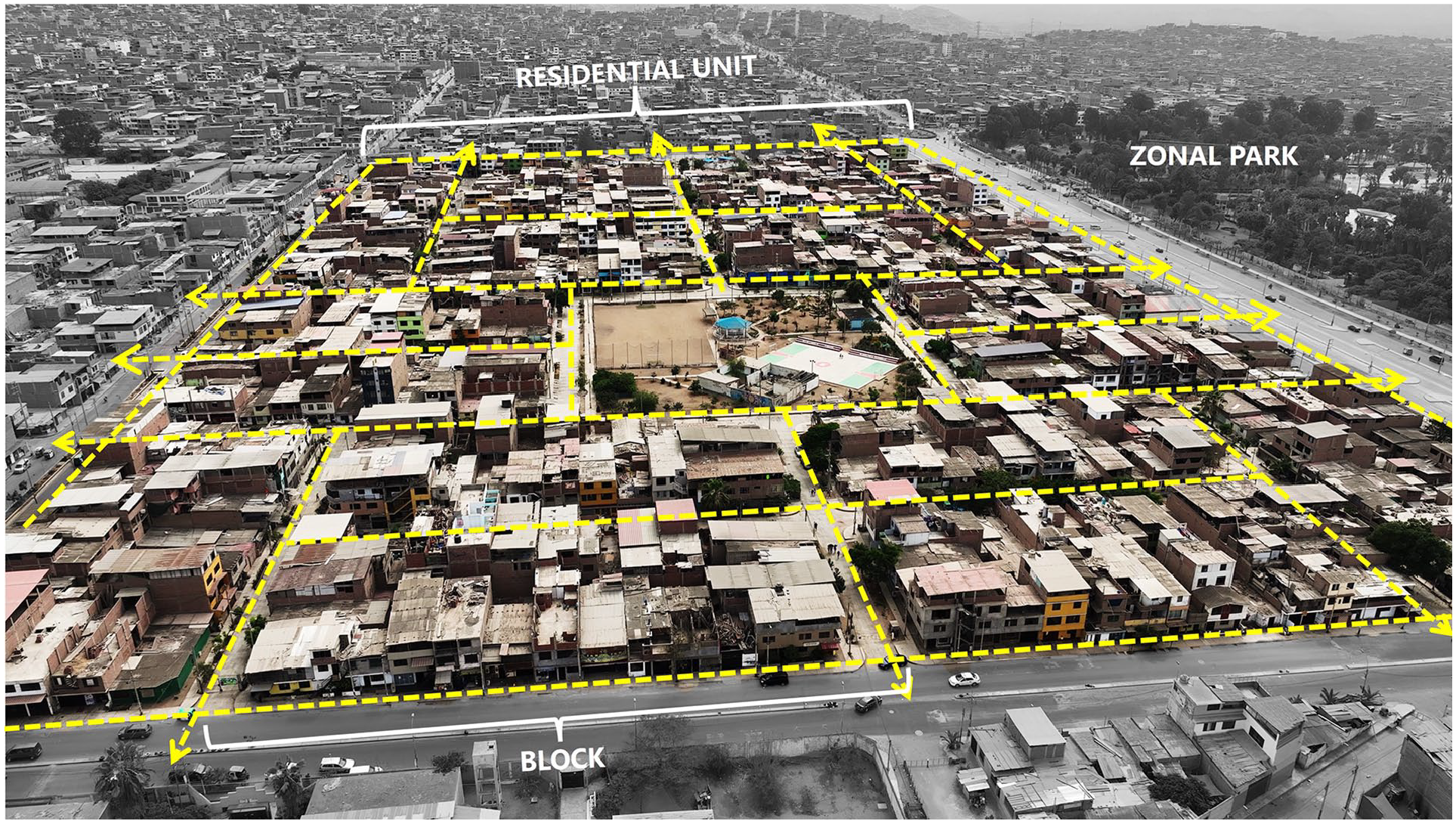
Residential group pattern analysis (Residential Group N°24, Sector III, in Villa El Salvador).
Finally, Villa El Salvador as a case study, emerges as a contemporary and tangible example, representing a set of identifiable characteristics associated with both urban traditions. Initially, a formal, efficient, and organized land occupation is observed through a territorial zoning model divided into three parts, aiming for the labor and economic autonomy of the entire community. The territorial model is located and positioned as an extension of the existing city under the logic of
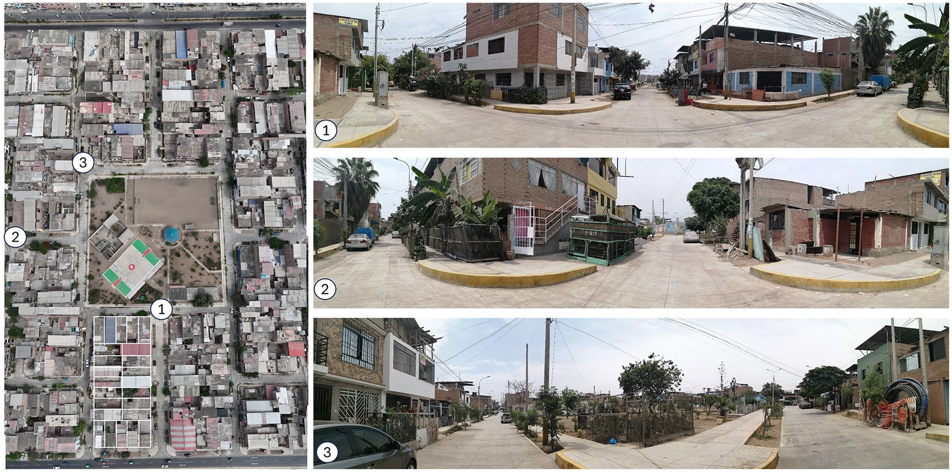
Left: Detailed aereal photograph of central park and surrounding blocks in Residential Group N°24, Sector III, in Villa ElSalvador. Right: Street level photographs of Residential Group N°24, Sector III, in Villa El Salvador.
Discussion and Conclusions
A
Assessing repetition patterns in the Andean and Western urbanism and, ultimately, in Villa El Salvador, provides an understanding base of the latter beyond its immediate context and circumstances. However, while this initial analysis initiates the theoretical discussion about Villa El Salvador, a more comprehensive examination in subsequent stages is essential to scrutinizing its morphological and socioeconomic evolution over time. This comprehensive approach will help identify its key achievements, limitations, and potential.
Based on the
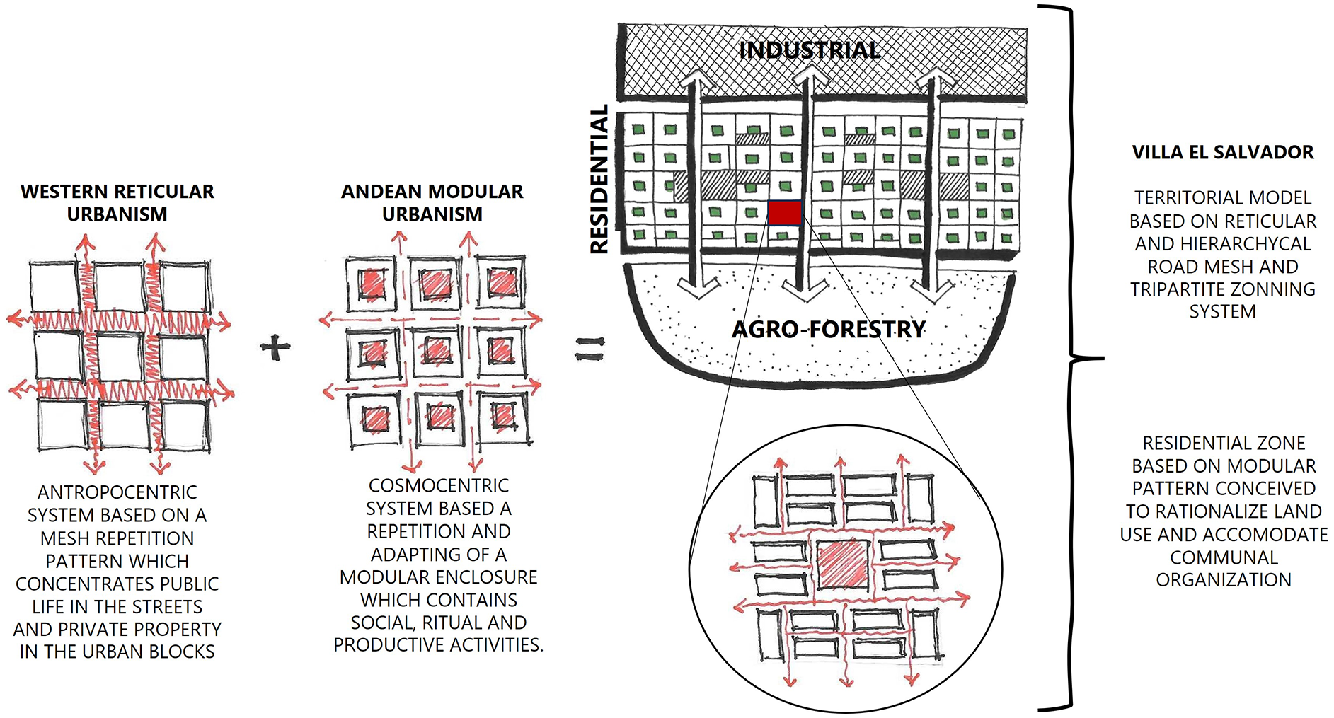
Graphical synthesis: Urban form of Villa El Salvador as a blend of Andean and Western urban heritages.
Thus, Villa El Salvador emerges as a crossbreed urban model that harmoniously incorporates the formal and functional aspects of both Western and Andean urbanistic traditions. This blend ensures rational and efficient land use while concurrently fostering an urban structure that supports the development of communal organization, thereby facilitating the growth and evolution of the community and urban space. The significance of Villa El Salvador’s urban structure during its genesis and early development is acknowledged by those involved in the process. Likewise, the enduring relevance and possibilities of this structure in the contemporary context present a substantial opportunity for research in the
Footnotes
Acknowledgements
The authors would like to thank Mr. Eleazar Cuadros for his invaluable contribution through drone images of Villa El Salvador and students Grecia Barrón, Valeria Campos, and Karime Yarasca for their assistance in plans and graphics for this research.
Declaration of Conflicting Interests
The author(s) declared no potential conflicts of interest with respect to the research, authorship, and/or publication of this article.
Funding
The author(s) received no financial support for the research, authorship, and/or publication of this article.