
Abstract
The memories of landscapes that people hold can stabilize histories and traditions in rural areas, are entwined with everyday lives and have several meanings. The paper explores the memories that people hold about plateaus in two adjoining villages (Alor-Uno and Edem-Ani) in the Nsukka area of Enugu State, Southeastern Nigeria. This area is an exciting and essential area of the world, distinctly underrepresented in landscape memory scholarship. The paper shows that the plateaus separating Alor-Uno and Edem-Ani are landscapes of political memory of the ancient wars between the two communities and more contemporary disputes regarding territorial extent of the communities and use of the land behind the plateaus if you are in Alor-Uno. Alor-Uno claims that wars waged against it by several kingdoms displaced the community, permitting occupation of parts of the community’s land, and they seek to reclaim it from Edem-Ani. However, extant narratives often recognize the disputed area as part of Edem-Ani because of the use of the plateaus as a boundary by colonial administrators. The presence of the plateaus helps the people recollect these ancient wars’ memories, and they use it to seek legitimation of their claim over the land. The paper argues that the memory of past land use reinforces the legitimacy of current land tenure configurations and shapes sensitivity to territoriality leading to exclusion. This can sustain group identities across generations translating into a ground for future fighting. It calls for more attention to the non-human agency and in connection to landscapes’ political memory, which speaks to the current post-human thinking in human geography. It suggests that resource conflicts analysis should take social meanings, memories and identities connected to the physical landscape seriously, as they contain ideological and symbolic elements foregrounding conflict environments.
Introduction
Mundane memory spaces can enhance our knowledge of how the past shapes places and identities and produce an array of memories and linkages with the past (Wheeler, 2014). It has been recognized that the connection between memory and place is knotty, with both individual and ‘social’ memories performing a vital role in processes of place-making and identity (Hoskins, 2012). People’s memories of a landscape, be it either a ‘formal’ or mundane site, can be linked to conflict, war and other traumas (Baird and Le Billon, 2012; Baird, 2014). There have been efforts to understand the sociocultural meanings and significance of the physical landscape in Nigeria (Okolie, 1992; Ugwuanyi and Schofield, 2018; Ugwuanyi, 2020). Other efforts have been on exploring cultural landscapes in Nigeria, such as Afamefuna and Okonkwo’s (2019) investigation of the Sukur cultural landscape in the Adamawa State of Nigeria.
Similarly, Muhammad (2017) examined the cultural landscape of the Nupe people in Central Nigeria. He noted that one of the distinguishing features of the cultural values of the Nupe people is their tangible and intangible cultural landscape transactions. Ugwuanyi (2021) explores how heritage knowledge is built around time-space discourses in Africa, drawing on the lived experiences of the Igbo of Nigeria. It shows that local knowledge systems are visible on the landscape via human–nature ‘relational ontologies’, and such pictured living holds heritage in a continuum across generations. Despite these studies focusing on exploring the social meaning and significance of physical landscape plus those analysing cultural landscapes, there is no attention to the political memories people hold of physical landscape features in Nigeria. Thus, it is vital to explore the memories associated with the physical landscape of Nigeria. In this context, this study explores the memories that people hold of plateaus of two villages (Edem-Ani and Alor Uno) in Nsukka local council of Enugu State in Southeastern Nigeria.
The focus on Nsukka is not because the Nsukka plateaus are the only ones that can reveal the social memories and imaginings of plateaus as landscapes. There are many other significant plateaus in Nigeria, such as the famous Jos and Mambila plateaus and the Obudu plateau. However, the study was inspired by the first author’s visits to areas near the plateaus separating Edem-Ani and Alor-Uno in the Edem-Ani region. Repeated attacks on valuables such as crops and pillars on the plots in the area by Alor-Uno youths prompted the author to investigate what such attacks were about and their historical roots. Interestingly, exploring the Nsukka plateaus is vital because of the limited investigation of the memories associated with plateaus in Nigeria. This research will thus help further studies of the memories and social meanings of other plateaus in Nigeria.
Professor G.E.K Ofomata labelled the Nsukka region as a plateau. Since then, it has become commonplace to call the area a plateau because of the numerous table-like hills dotting the physical landscape. However, plateaus are not the only physical landscape features there. The biophysical characteristics and significance of Nsukka plateaus have been studied (e.g. Phil-Eze, 2012), but the memories and social meanings that the people hold of plateaus have not been explored. However, this is not to say that nothing has ever been written about the social imaginaries of plateaus, for example, Yeh’s (2013) work on the Tibetan Plateau. Also, Shea’s (2019) paper links memories and narratives to place identity and fondness in varied neighbourhoods around the Cumberland Plateau in Tennessee, USA. This present study shows that the communities deploy the memories people have connected to the plateaus to lay claim to the land and seek legitimation of their claim. Wars waged against Alor-Uno by several communities shattered and displaced the community and led to the takeover of the community’s land.
The presence of the plateaus provides a sense of these past struggles and connects to the present struggles to reclaim the land behind the plateaus by Alor-Uno. Edem-Ani is defending against the takeover of the land. The paper argues that the analysis of resource conflicts should take social meanings, memories and identities connected to the physical landscape seriously, as they contain ideological and symbolic elements foregrounding conflict environments. Besides, it makes several contributions to strands of landscape memory literature. Among other contributions, it shows that the memory of past land use reinforces the legitimacy of current land tenure configurations and shapes sensitivity to territoriality leading to exclusion. This can sustain group identities across generations translating into a ground for future fighting. It calls for more attention to the non-human agency and in connection to landscapes’ political memory, which speaks to the current post-human thinking in human geography. The article is structured as follows: presentation of the methods, conceptual discussions on the landscape, nexus of landscape memory and identity and landscape, memory and conflict. Then the study area is discussed. The rest of the article reports the finding before the discussion.
Methods
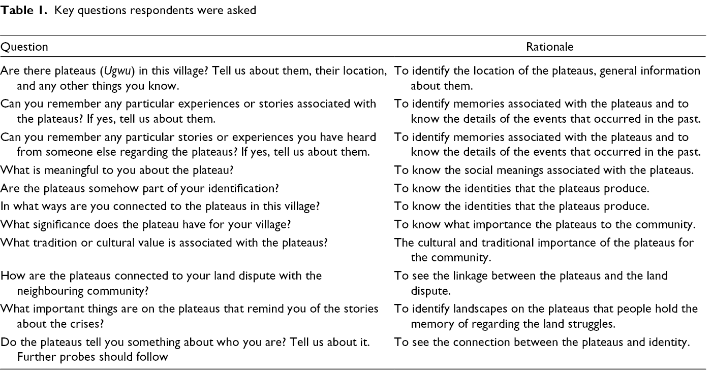
The research was conducted in two communities (Edem-Ani and Alor-Uno) in the Nsukka local government area (LGA) of Enugu State, Nigeria. Nsukka is the principal town in the area formally grouped under the old Nsukka division, which, as Afigbo (1981) indicated, occupies the northernmost part of the northern Igboland. The Igboland is the area inhabited by the Igbo ethnic group in Southeastern Nigeria. The study was conducted between January 2020 and August 2020, with a return visit in January 2021. Two primary sources of data were used: in-depth oral interviews and field observations. The purposive sampling strategy was used to identify knowledgeable individuals and then snowballed from early interviews and existing connections. We targeted knowledgeable indigenes within and around the villages who lived in the village for at least 10 years because they are more likely to have in-depth knowledge about the subject. This is not to say that those who are not indigenes or have not lived in the village for an extended period do not have memories of the events connected to the plateaus. The participants included traditional rulers and village heads, among others. We interviewed 23 persons, which amounted to 48 interviews because some were interviewed more than once on different days, especially Onyishi, elders and youth leaders, to verify consistency in their opinions.
The participants discussed the subject using semi-structured interviews, often on multiple occasions, and with follow-up interviews. The information elicited from them is their opinions, stories, statements, identities and practices regarding memories and social meanings of the plateaus as landscapes. These form the material data for this study. Besides the general introductory questions of getting to introduce the researchers and the aim of the study, the questions in Table 1 are the key questions that the respondents were asked. Some follow-up questions were asked during the interviews, but these were based on the responses, especially in a further probe of grey answers. Data analysis involved identifying and evaluating themes and patterns and relating them to the research questions posed by comparing previously collected data (Memon et al., 2017). This enables us to assess the reliability of the data collected and make necessary adjustments when necessary (Clark and Vealé, 2018).
Key questions respondents were asked
Ethical standards concerning conducting interviews were upheld. While some participants signed the consent letter, others declined, especially the less educated. Still, we asked if they consent to be interviewed and, once they agreed, we proceeded with the discussion. The participant’s personal and identity information was not directly indicated in the research report except where the participants permitted it. The interviewees were between 40 and 90 years old, with varying educational backgrounds. This reflects that interviewees were of diverse backgrounds to get a broader perspective. Pertinent for this paper is their knowledge of their village’s history, traditions and values, including oral traditions about the plateaus in the village, which underpinned this study. For many, their sense of being Edem-Ani or Ero was rooted in being born in their village. Still, they avow their ethnic identity of being Igbo, their native language and familial links. Many identify as Christians, while others as traditionalists with very few Muslims. Here, traditionalists are those who practice animism, that is, those doing spirit worship.
The conceptual approach to landscape
Landscape has been understood varyingly across disciplines. However, within human geography, three perspectives have emerged: labour as productive of and shrouded by landscapes; landscapes as associated with seeing and the sense of sight; and landscape as lived, embodied and practised (Neumann, 2011). Despite their interlinkages, the third perspective is pertinent to our study. It conceives landscapes as phenomena that people hold memories in connection with them – lived experiences of society that are relived via landscape memories. This perspective is also akin to the although no longer ‘new cultural geography’ tradition. There has been a call for a more empirical approach to landscape and jettisoning Marxist foundations in most of the new cultural geography, plus the theoretical structure (Rose, 2006). Merriman et al. (2008) argue that the authors advancing these critiques sometimes favour the new cultural geography. This development indicates that the advancement of landscape theory cannot be aided by the historical fissures and conceptual dualisms (Merriman et al., 2008). Thus, Neumann, 2011 argues that there is no unified theory of landscape within geography, and it is difficult to claim that the different traditions are entirely inadequate. Thus, the sympathy of this paper lies in the new cultural geography.
Carl Sauer’s (1889–1975) thoughts have been influential in the theorization of landscape within human geography. His landscape reading drew on cultural and historical geographies to conceived landscape as a physical material reality we are absorbed in with all our senses. Sauer (1963) defined landscape as the result of exchanges between the natural environment and a cultural group in which culture is the agent. The natural environment is the avenue via which the cultural landscape is produced (1963b: 343). Among the many critiques of the Sauerian approach (e.g. its ‘superorganic’ culture reading), social heterogeneity, inequality, stratification, and power imbalances and exclusion were insufficiently theorized and tackled (Duncan, 1980; see also Wylie, 2007). Therefore, the Sauerian landscape tradition lacks a critical treatment of social and political issues recognized as the vital constituents and drivers of the landscape (Wylie, 2007). These are relevant to how we conceptualized landscape in this study as they help reveal some of the drivers of land struggles that are remembered because of the memories that landscape produce.
J.B. Jackson’s ‘vernacular landscape’ conceives landscape as produced by the mundane everyday practices of people who live and work in a place (Jackson, 1984, 1997: 343). Despite the criticisms levelled against it for its distrust of formal theory (Cresswell, 2003), it is remarkable for maintaining that landscape has symbolic and material roles because of people associate myth, memory, meaning, imagination and symbolism with them (Cosgrove, 1998). It thus follows that landscape is the summation of all aspects of a region, as conceived by humans (Ermischer, 2004). People’s memories of landscapes are critical to the past, implying that beyond their physical presence, landscapes remind people of some processes that occurred in a place (Fowler, 2004). Gunner (2005) argues that in some cases, a group’s principal allegiance to the significance of a specific landscape, and land, is connected to its ideological and symbolic import. This does not regularly discount the chance of possession being concurrently visualized in a more material way (McGregor, 2003). This helps think about how the landscapes, such as those shaped by the brutal tribal wars, shape the discourses of the conflict presently. This review shows that a landscape has broader social meanings in which cultures are formed and articulated, as well as social heterogeneity and inequality, power imbalances and exclusion. It shows marks of the lived experience of people who have dwelled in it, offering both continuousness and a sense of the past (Ingold, 1993). We now turn to how memory is approached in the paper.
Memory, place and identity
Memory enables remembering – a sense of connection to the past life. Recollecting is a social process representing the values, experiences and knowledge that individuals, a community, or society deems vital and essential, which are retold and sustained via memory work (Shea, 2019). Remembering goes beyond establishing ‘objective’ facts and specifics to include how we frame our experience, prevalent stories, the unique way we structure the political and social experiences that shape our lives. Social context is vital to memory and remembrance because it is in society that we recollect, recognize and localize our memories. It also makes sense that the memories we embrace tightly as solely ours are made and remain firm in negotiation with the social domains we dwell. Thus, individual memory occurs via interpersonal exchanges that were previously social, cultural, collective and public. While memory is social, it is also significantly socially temporal (Barlow, 2017; Shea, 2019). Thus, memory produces different stories over time and creates new linkages with the past, present and future based on context, drive and environment.
There are excellent connections between place and memories. Shea (2019) argues that memory is social and significantly tied to place. In exploring the place–memory nexus, Donohoe (2014) contends that place informs one as belonging to a particular group and shapes one’s appreciation of people and the world. Hence, the place is vital to the way of life as we are continually partaking in places (Pink, 2009). Place is also vital for thinking through memory, just as (re)productions of memory are evident in public and private places (Drozdzewski et al., 2016). Sumartojo (2016) argues that the creation of personal memories can be triggered by one’s presence in a physical place before or by sensual experience in that place, or those sensual experiences could have engendered recollections of several places and various periods. Memory also shapes communities’ sensitivity to territoriality, such as monitoring the boundaries of places. It also negotiates between belongings and exclusion and between acceptable and barred usage of space or land over time (Shea, 2019). Therefore, the relationships between place and memory are powerful. Place's memories can thus be employed in directions that aid the calculated politics of memory just as memory landscapes are (re)constructed and preserved for specific reasons. Thus, memory-filled political landscapes entail places shaped by the recollection of public memory contested by groups who battle to achieve hegemony to symbolize and narrate their past selectively.
Memory is connected to identity; it gives us a sense of what we are and continually shapes our lives (Damasio, 1999; Till and Kuusisto-Arponen, 2015). Onuoha (2013) indicates that depictions of the past via memory are essential to the symbolic designation of social groups, place and identities. Identities, national or otherwise, are formed and preserved via a range of memory sites (e.g. landscapes), traditions and forms. Competing histories strongly connect to a group’s identity and are crucial for encouraging social exclusion, belonging and social identity. Memory is pertinent both for the present and the future, in creating or remaking, asserting or declining group identities, in claiming land and other resources, and in several other issues (Longman, 2017). Memories of oppression, anguish and exclusion can sustain group identities and come to be lived through across generations translating into a ground for future fighting (Onuoha, 2016). Identity is continually produced in narratives. The ways we are positioned and position ourselves in past narratives are what defines identities (Huyssen, 1995: 1). It thus makes sense that exploring communities’ narratives of their past can reveal how identities are shaped by memory.
Landscape, memory and conflict
Landscape constitutes a place full of memory (Kiriama, 2018); hence, it constitutes both what we can see and what is inside our heads (Meinig, 1979; Schama, 1995). Landscape matters to many rural people, including the Igbo of Nigeria. Land, Ala (the Mother Earth), has a vital place in the Igbo culture and tradition, signifying the human–nature relations. Ugwuanyi (2021) has indicated that local knowledge systems in Igboland are written on the landscape via human–nature relations and continuity of the knowledge across generations that began with known ancestors. Ugwuanyi (2021) relied on memorized narratives of landscape features among the Igbo of Nigeria to justify his theorizations on ‘territorial communion’. In line with this, the continuity of the local knowledge system is enabled by the memories specific landscape’s presence evokes, especially the told histories and traditions of villages. Without memories, the meanings of landscape, and indeed the heritage they hold for the people, may be lost. Ugwuanyi followed Ingold (2005) to clarify the significance of Ala in Igboland to establish human–nature relational systems that ensure the survival of heritage across generations. The things the people have done, placed and institutionalized on Ala are the products of human and non-human interactions. The landscape conveys the images of this communion across generations. The human–non-human relations in connection to memories enable the modalities of becoming in which human and non-human life and place merge in connection to temporalities to keep the past alive both now and for the future (Harrison, 2015). Landscapes’ presence enables the recollection of memories as they house what societies make of the past, offering a sense of the past and continuousness.
Landscapes are indeed places of social and political relations as well as everyday lived experience. Memories of particular landscapes can differ between different groups who symbolize their past with that landscape, hence conflicts. Conflicts occur in politically charged spaces, and the memory markers can explain this on those landscapes. Memories are associated with politically charged spaces and landscapes (Baird, 2014). Baird (2014: 63) argues that memories are vital for incorporating past conflicts into histories and culture. This is principally the case for societies that treasure the elders’ chronicles and oral history in conveying social memory. Marschall (2010) reasoned that memories are essential to fuelling solid emotions and even initiating violence. It does make sense that landscape, memory and conflict are interconnected. Landscape can help us better understand how past conflicts are remembered and what it means to the present generation, and how they engaged in the conflict. Studies have explored the connection between post-conflict spaces and memory, including Halilovich and Fejzić’s (2019) exploration of the memory landscape connected to the conflict in Bosnia and Herzegovina. Baird (2014: 61) indicates that political memories shape contemporary politics concerning battles, for example, those against the exclusion in access to land and resources. These are landscapes that were visualized not only in terms of the wars but also in association with memory (Baird, 2014: 63).
Baird and Le Billon (2012: 290) interrogate how wars and their consequences often change land use and ownership, transforming post-conflict landscapes via ‘new boundaries, population movements, land reforms, and conditions of access’. Baird (2014: 64) reasoned that in several ways, representational imprints designate boundaries, signalling territories of different groups, and thus essentially establish space, hence ‘affecting access and exclusion’. Maandi (2009: 454) indicates that land rights become evident in the material landscape via such things as boundary signs and other human-made imprints, in addition to the legal or illegal activities, which affect the shape of the land. Baird and Le Billon (2012) indicate that memories of past tenure and use of the land by local people are vital for legitimizing access and makes it easy to ‘Other’ the newcomers (or supposed landlords who have not used) the area. Gunner (2005) notes that this can be seen from the perspective of conflictive exchanges regarding dispossession and resistance between victor and defeated and settlers and the exiled. These connections between landscape, memory and conflict reflect how Edem-Ani and Alor Uno are associated with the plateaus separating them as landscape. Thus, landscapes are filled with politics because of the past political events (e.g. wars) associated with them.
The study areas: History and geography
The study areas comprise Edem-Ani and Alor-Uno (Figures 1 and 2). These two communities are in Nsukka LGA in Enugu State, Nigeria. Edem is politically organized into three zones. Edem-Ani is one of the three zones of Edem ancient traditional state. The other two are Akpa-Edem and Ozi-Edem. The Eze Edem (King of Edem) is the head of the kingdom, and the three zones are headed by Onyishi – the eldest man in the zone. This political institution dates back over 900 years. The focus is on Edem-Ani, which is in the northern part of the Edem Kingdom and has 14 villages, among which Umuchiagwu has been in enduring conflicts with Alor-Uno’s traditional kingdom. Initially, the other villages supported Umuchiagwu in the conflict in ancient times, but since the 1800s, Umuchiagwu fought alone. Both Edem and Alor-Uno (originally Ero-Uno until 1958) claim historical ancestry to the Igala Kingdom, not of the Igboland, but they identify as Igbo today. The ancestor of Alor-Uno is Ozuzukoko, a hunter who settled in Alor-Uno because there was fertile land he could cultivate and animals to hunt. He begot three sons named Ibakwa-Aka, Alor-Uno and Ibagwa-Ani. Alor-Uno had three sons named Uwani Alor-Uno, Ajuona Alor-Uno and Amikpo Alor-Uno. These three sons formed the three quarters in Alor-Uno, and their children are the villages now found within the kingdom. A fourth group – Ugbene – is seeking recognition as a quarter. Ugbene is an aggregation of people who settled in Alor-Uno following their worship of Adoro-Ero, a goddess in Alor-Uno. For this reason, in ancient times, they had limited social recognition. Intermarriage between them and the natives is rare, and they are not permitted to celebrate the Adoro festival at the same time as the natives. They cannot attain the position of Adoro priest.
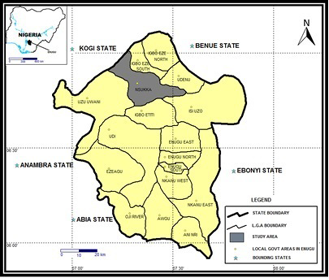
Nsukka in Enugu State, Nigeria.
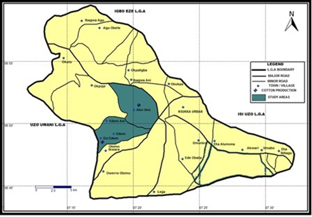
Showing Alor-Uno and Edem-Ani in Nsukka, Enugu State, Nigeria.
Much of the histories of Edem-Ani and Alor-Uni are interconnected because they are neighbours and share the same ancestral roots as they belong to the Igala ethnic group. Also, much of the history of these two communities aligns with the history of Nsukka – the primary settlement in Northern Igboland. While both communities were gerontocratic, Alor-Uno was more autonomous because Edem-Ani was politically tied to Edem’s autonomy. In Nsukka, there were inter-village conflicts, mostly over land tenure and resource control, besides conflicts waged against the Igala army (1830s–1850s) invading from the north. Igala raids dominated the northern parts of Nsukka in such places as Enugu-Ezike, Imilike, Oba, Ibagwa and Opi. The attacks did not result in a total conquest but subjugated many villages and led to new villages like Edem and Alor-Uno. Some of the villages were ruled directly and others indirectly through one of the Igala kingmakers known as the Ashadu. These events influenced the reciprocal sociocultural influences between Nsukka and Igala (Apeh and Opata, 2009). It is vital to note that there was a slave community in Alor-Uno. The fourth quarter (although unrecognized) in Alor-Uno, that is, Ugnene-Ero, is regarded as the remnants of those slaves and is discriminated against by the other quarters. The Afor market in Alor-Uno blossomed, which became the envy of many surrounding communities.
The villages of Nsukka, including Alor-Uno and Edem, were among the Eastern Nigerian societies with late contact with Europeans in the 1920s (Achebe, 2005). The slavery practices introduced by Europeans impacted the egalitarian polity with entrenched democratic principles and freedom constructed on reciprocal ideals for the individual and the society (Abidogun, 2007). Plateaus played significant roles in evading adoption by slavers and the Igala raiders, and also served as a site where the people could fight back to wade off the intruders and are still remembered as such. The introduction of colonial rule and the Christian missions led to the Western education model and an indirect form of political administration (Apeh and Opata, 2009; Odugu, 2016). Nwankwo (2019) indicates that 18.7% of the Enugu population was Christian in 1952, but based on projections, it was over 77% in 2019. Colonial administration impacted traditional boundaries between communities in an attempt to create administrative divisions. This sometimes led to boundary disputes, which the colonial court may seek to resolve. In other cases, the boundary conflict may not have predated the colonial rule as in Edem-Ani and Alor-Uno. Still, the colonial administration tried to resolve the dispute by using natural boundary markers such as hills and rivers.
Land disputes were further aggravated by the various post-colonial governments’ balkanization of the country into states and local government areas to hinder the secession of regions from the country, like that attempted by the Eastern Region as the Biafra Republic resulting in the Nigeria–Biafra War. The division put sister communities into different local government areas. Some in the northernmost part now fall under either Kogi or Benue states. The establishment of the University of Nigeria in 1960 is perhaps the most significant post-colonial event in Nsukka history. The university has been a driver of the intense social, economic and political development of the region. Much of the communities remain in relative peace except for the continuation of the Edem-Ani–Alor-Uno border dispute, which was temporally put on hold by the advent of the colonial rule. Figure 3 shows the positions of Edem-Ani and Alor-Uno, the plateaus and the disputed area.
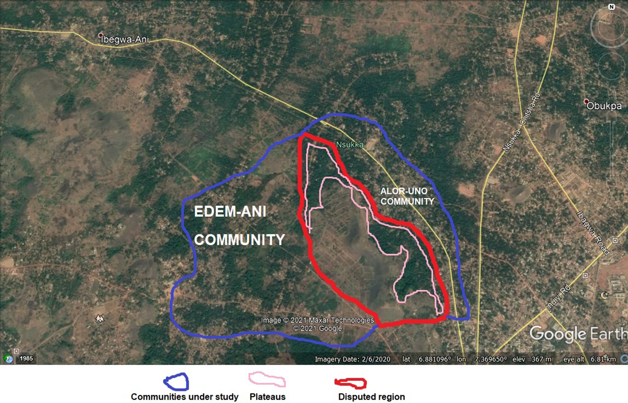
A Google Earth image of the two communities.
The geography of the two communities is much the same. Plateaus surround both Edem-Ani and Alor-Uno. So, they are communities in the valley. This geographical location has contributed to soil fertility, which provides the basis for their source of livelihood – agriculture. For Alor-Uno, the most vital benefit of living in this valley is that it provided a haven from wars and enemies. Vegetation is mainly of grasses, shrubs and standalone trees. The significant landscape feature in the area is the plateau. Both Alor-Uno and Edem-Ani have a stream, namely the Iyi-ahihia and Iyi-oku, respectively. The plateaus have economic, developmental and symbolic implications. Some villagers mine stones used for the construction of house in the plateaus, providing a source of livelihood. Development wise, the plateaus are argued by Edem-Ani to hinder their socio-economic development because they limit the accessibility of Edem-Ani.
Indigenous beliefs in Nsukka have often classified plateaus, particularly their summits, as sites of potent forces of nature, and they are generally portrayed symbolically as deities. These beliefs seem to reproduce as antique and current, signifying how societies connect to a specific place and live with local, often centuries-long knowledge. The plateaus have variegations of meaning and responsibilities for a community. In most cases, the plateaus have some spiritual significance, but not all plateaus have this import. The sacred plateaus usually have similar physical appearances, such as not having any adjoining plateau, that is, standing alone and having a dome shape with a tabletop and a flat top of between 20 and 30 square meters. Traditional rituals and festivals are performed atop specific plateaus, such as the Omabe masquerade festival. Some plateaus with these features also serve as prayer grounds for Christians (Figure 4).
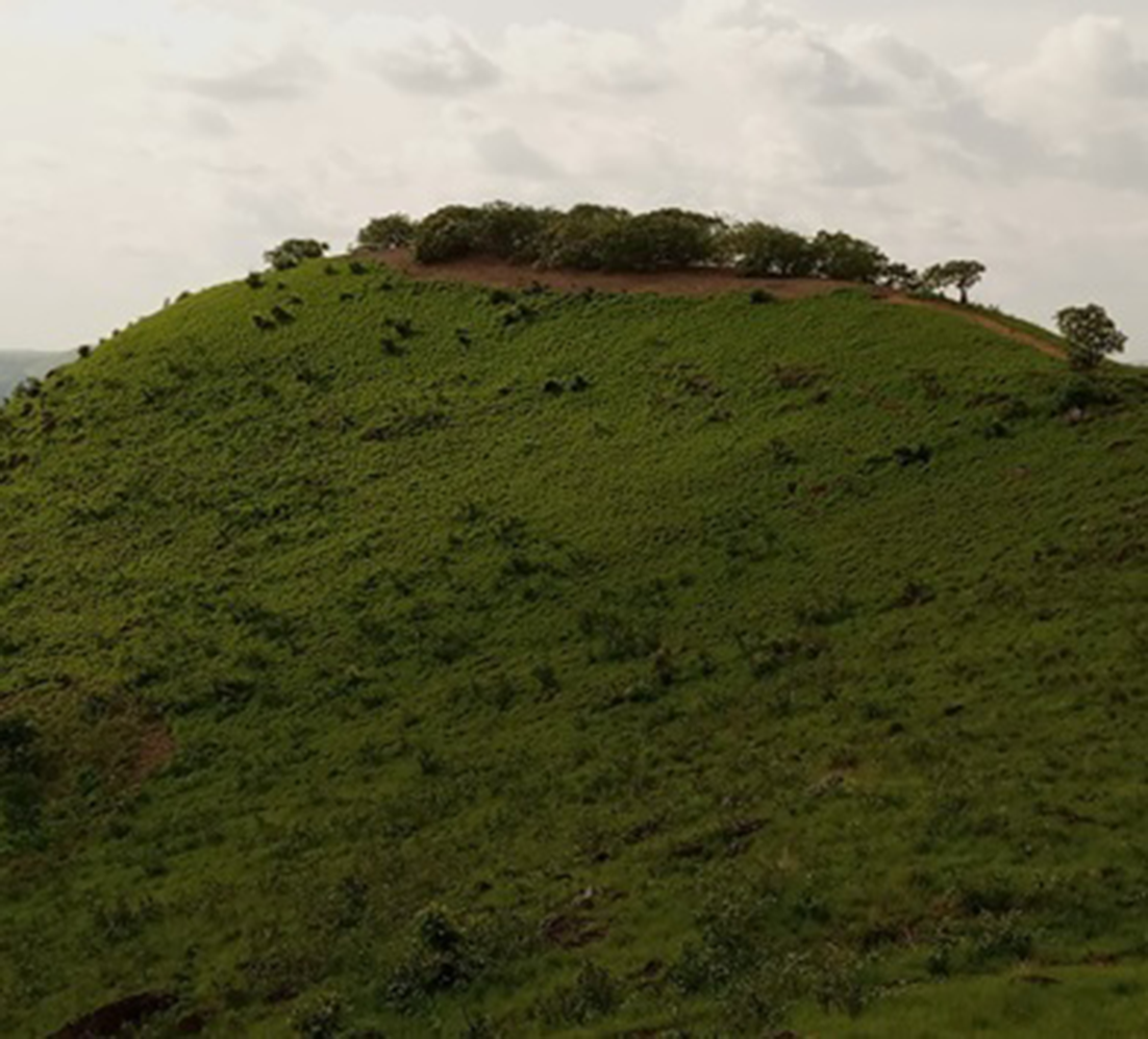
Place of prayer atop a plateau at Ugbene-Enu Village, Alor-Uno.
Landscape memories of the land struggles between Alor-Uno and Edem-Ani
Stories of the struggles
Like wars between Umuchiagu of Edem-Ani and Alor-Uno, historians indicated that inter-village and inter-tribal wars in pre-colonial Igboland were driven by the desire of powerful groups to access resources and possess the land (Egboh, 1972). The beginning of the dispute between Edem-Ani and Alor-Uno cannot be pinpointed. Still, the major wars could be remembered as told by past generations, and the sighting of the plateaus separating the two kingdoms evokes memories of the wars. The major battles that could be remembered occurred between the early 1800s and late 1890s. The advent of colonial rule that somewhat brought together many disparate communities under one administrative division rescinded the fights over property and territory. The colonial era influenced the landscape, in that it established the boundary between the two villages in the middle of the plateaus’ top using stones assembled in a straight line. However, the memories of the brutal wars remained and often ignited tensions between the people.
Our study began with a visit to the disputed area for observation. We observed stone relics at the top of the plateaus and inquired about their significance. The interviews began with the eldest man (Oyinshi) in the two villages because they know the stories a great deal, but some younger people know the tales without much detail. The Onyishi of Ugbeleegu in Alor-Uno stated that they are the rightful owners of the disputed land because, since ancient times, their forefathers farmed the land up to forest area in the Southwest and Odenigbo in the Southeast axis. However, Edem people migrated across the hills at Odenigbo to settle in the valley of Edem hills and our hills which we designated for farming (Interview with Oyinshi Alor-Uno). He argued:
The conflict is caused by the fact that the Umuchiagwu people of Edem are migrants that want to take our land by force. So, we are defending against the invaders. The stone relics on top of the plateaus are used as shields against Umuchiagwu during the war. The claim that it is the boundary between us is false. We used trees as boundary demarcation. The tree we planted as boundaries have grown into a forest. We planted Ube trees to designate our boundary with Edem.
We asked the Onyishi of Ugbeleegu where the said trees are located, but he could not expressly state it. One of our key informants in Alor-Uno, Mr Goffrey Eze, noted that ‘our people marked big live trees as boundaries and then planted fire-resistant trees in-between. However, most of those trees have been removed by greedy farmers wanting to expand their farming spaces’. Alor-Uno positions itself as a vulnerable species targeted for extinction because of the many wars waged against them. Mr Eze explained that, during the 1890s, there was a civil war between Alor-Uno and the surrounding communities. “We call the war Aya Ebiriba” (Ebiriba War) because “Ebiriba war mercenaries were hired to fight against us”. The surrounding communities were envious of the success and prominence of Alor-Uno, which was engendered by the famous Afor market in Alor-Uno. He noted that:
The war led many Alor-Uno people to vacate the land that is being contested. After the war, Edem people occupied the land and have refused to leave even when our people returned from exile. Our land extends up to the Odenigbo area in the south and the entire University of Nigeria campus in the east because we shared a boundary with the Orba community.
On what the stone relics (see Figure 5) on top of the plateau represent and the memories they hold, Mr Ezeh argued that
the stones are not the boundaries between Edem-Ani and us. Stones are not natural boundaries. They are used to demarcate internal farm boundaries. We do not share in the thinking that they are community boundary.
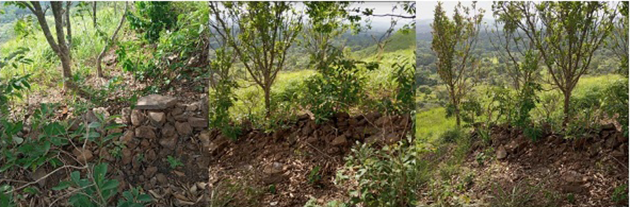
An assemblage of stones at the top of plateaus on the Alor-Uno–Edem-Ani disputed boundary.
The Onyishi of Umuchiagwu of Edem-Ani village and the Attama of Iyioku – that is, the chief priest of Iyioku deity – stated that the war was caused by the mutual claim over the disputed space. Still, the land is in Edem-Ani’s territory. Based on stories passed down to him by his father, he recalls how the major battle was fought. He noted that the conflict was often between farmers from either village, as both cultivated the land in ancient times. The root of the conflict lies in the attempt by Alor-Uno to stop them from using the land. Mutual killings across many years resulted in large-scale wars in the late 1890s.
In the last large-scale battle, they [Alor-Uno] climbed the hills, we were at the valley, and they continually pelted us with stones. We fought back by sending some of our warriors to go through the sides of the hills to capture some of their people and their livestock. There were casualties, and many of them, including other villages in Alor-Uno, fled and were displaced for many years. Some did not return till today, such as those that settled at Ero-Egwu in Enugu-Ezike.
He noted that the stone relics also remind him of the story of how, in his words, ‘white men’ – colonial administrators – resolved the boundary dispute that led to the war (Interview with Onyishi of Umuchiagwu of Edem-Ani). He stated that stones were used for the boundary demarcation because fire cannot destroy stones other than trees that were previously used – as such, shifting the boundary would be difficult. The establishment of the boundary at the top of the plateau affirmed Edem-Ani’s claim that those behind the plateaus cannot be considered as belonging in their ‘homeland’ and, as such, cannot have access to land tenure. So, it produced a binary identity of the Self and the Other. Thus, although cultural and patrilineal affiliations primarily define the identities of the communities, the plateaus shape identities as they now establish those who are called Ndi Edem-Ani or Ndi Alor-Uno (People of Edem-Ani or People of Alor-Uno). However, this mutual labelling and brutal territorial wars have not significantly damaged their relationship in other realms. They attend each other’s feasts, intermarry and relate peacefully. However, this mutual respect and association are abandoned once they meet at the disputed land.
Brutal fights over the disputed territory re-emerged following the end of the colonial regime. However, the fights were brought to a halt by Nigerian–Biafra War because Nsukka was the first area to be captured by the advancing Nigerian army from the north. The people could not engage in further brawls but run for safety. The state and federal governments’ interventions stopped further fights after the Nigerian–Biafra War. For this reason, the conflict has taken the dimension of court disputes, but there are irregular fighting episodes between individual farmers that may be brutal but not lasting. Edem-Ani claimed that the customary court judgement declared them the rightful owner of the land. Mr Eze argued in his words that Edem-Ani had an ‘administrative advantage’. Edem-Ani has had better representation and influence in the local, state and federal governments. He noted that Alor-Uno had appealed the judgement in the high court, and no judgement has yet been made.
From these stories, Alor-Uno always remembers the disputed area (Figure 6) as a place where their ancestors dwelled but were murdered and removed forcefully by their enemies. For Edem-Ani, the site is remembered as a place their ancestors cultivated and that is being contested by an enemy who wants to dispossess them of their inheritance. What is established from the two versions of the wars is that Alor-Uno was displaced, whether or not they are the rightful owners of the disputed area. However, the representation of memories linked to stone relics on the plateaus and plateaus as a boundary is varied and contested. These differences emerged because each community tried to make their position seem truthful and the other’s accounts false to ensure that the disputed land was not lost to the other community. These different accounts have been passed down to their respective generations from the past, and the present generation holds them as truthful.
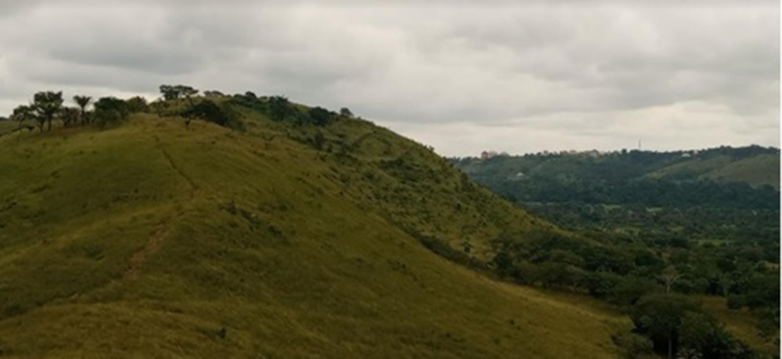
Igbogwodigwo area in Edem-Ani village: Part of the disputed area between Edem and Alor-Uno.
Of plateaus, conflict and memory
Adjoining plateaus separating these two ancient communities extend from the Odenigbo area in Nsukka town down to the Ugbeneelu area of Alor-Uno. The presence of these plateaus has since been the source of disagreements between Edem-Ani and Alor-Uno over the extent of their areas. Hence, the plateaus have become political landscapes – geographies that become politicized by the interactions between opposing actors (Boyer, 2015). Boundary objects and signs are essential for customary systems of land rights. The top of the plateaus has boundary markers such as assemblage of stones, particular trees used to designate village boundaries, and conflict markers such as having two sets of stone assemblages indicating the contestations for the boundaries. The boundary at the top of the plateau is disputed by Alor-Uno and has been a source of conflict in this post-colonial era. Essentially, the presence of these plateaus reminds the people of the past wars to reclaim a lost territory or to fend off a marauding land grabber.
The older people in the two villages recall conflict lucidly, even though some also endeavour, for diverse reasons, to suppress their recollections (especially Alor-Uno people), though most times without success. Although some of the plateaus were not markedly changed by these old times wars, their presence helps recollect those experiences. Thus, landscapes (such as these plateaus studied) are connected to history of the place , reflecting the past, which can be realized via material remains (e.g. the stone relics) or knowledgeable understanding reminding the past in the minds of the beholders and via social practice and dwelling in the place. However, we cannot restrict the production of historical landscape to human activities and alteration since the natural landscape such as the plateau can remind people of events (e.g. wars, land disputes) of the past generations, ancestors and ancient folks. Thus, the memories that people hold of the plateaus are produced through histories of the events connected to the plateaus made available via storytelling and oral tradition. People who have a knowledgeable understanding of the events retell the stories to the present generations.
The unique characteristics of the landscape impact the memories. The plateaus that shape the contested memories have unique characteristics such as elongation (i.e. long enough to stretch across a significant part of communities’ border). Some other plateaus are located within the villages but cover small areas and are isolated. The isolated plateaus may have other specific memories associated with them. Still, it is the adjoining nature of the plateaus at the disputed border that makes them be filled with the memories of the conflict since they serve as a referent element of territory – the central conflict driver. So, because they are closely packed, they leave no room for the two villages to expand their territory, indicating the agency of non-human in social relations. The informants in Edem-Ani argued that since there is no trace that Alor-Unos have dwelled in the disputed area, it means that Alor-Unos’ claim of being the original inhabitants of the area is false. For Alor-Uno, they claim that the difficulty in crossing the plateaus back and forth made them not build homes there and instead designated it as a farming area. This further suggests how non-human elements shape human agency. Thus, the adjoining nature of the plateaus, their immovability and massiveness shape the events that people hold their memories in connection to the plateaus.
Displacement, land use and territorial configurations
As noted in Alor-Uno, testimonials of disenfranchised people often have some sort of expressive memory for an ideal site left behind. The ideal site left behind is the land from where Alor-Uno claimed to have been displaced. This place is often inconvenient with a more practical tactic to retrieving the same place: memory contains many sounds, is often competing, and the land is often the catalyst for such disagreements. The memory associated with the landscape means that the present site is inevitably plunged into the multiple politics of the past. The displacement of many Alor-Uno people does not seem to be connected to their war with Edem-Ani and the Ebiriba war only. Another significant event was the war that happened between them and Nike over slave-trading interest in Nsukka Division. Nike was the principal slave dealer in northern Igboland. Alor-Uno was raided for slaves by Nike in the late 19th century, which led to the displacement of the community far and wide (Achebe, 2003).
Displacement can completely shatter communities and disorder land tenure, with a severe threat of ultimate loss when claims rest on the concrete occupation of the land. The memories of displacement of Alor-Uno and memories of land use by Edem-Ani shape the contemporary struggle for land use and territorial configurations. Alor-Uno claims that Edem people could only occupy the lands because of these wars that displaced them. However, given that the Edem-Ani people have used the land for many years, it has been challenging to establish Alor-Unos’ claim. The occupation of the land by Umuchiagu Edem-Ani is verifiable because of the presence of their homes. These memories of past tenure and the use of Umuchiagwu Edem-Ani are vital for legitimizing their claim. It provided the impetus for Edem-Ani to be widely recognized as owners of the area and to order access, and made it easy to ‘Other’ the supposed landlords (Alor-Uno) who had not used the area because of displacement by wars. These events help show how the memories of land usage across generations shape access and exclusion to land tenure between these groups.
Within each village, access to land and resources is primarily guided by the principle of indigeneity. Indigeneity here implies that you are recognized as a community member by being born by a native of that community, that is, because your father is originally from that community – not necessarily because you were born and raised in the village. Other factors may be considered, such as gender, seniority and class (interview at the study area). It is important to note that this definition differs from international definitions of indigeneity, which are about much more than being born in a particular place. Present land uses and territorial configurations are such that those who have used the land from the recorded past, which is as far as evidence can be provided, have had the upper hand in the decisions to approve land ownership, usage and, by extension, territorial extent. However, Alor-Uno claim to be the area’s original inhabitants before the recorded history of the area and up until the slavery era, even before the expansion of British colonial interests in Nigeria.
Current usage of the land and territorial configuration is that Edem-Ani is widely recognized as the owner of the area because of recollections and narratives that are verifiable, such as government compensation of Edem-Ani for using part of the disputed area as a now-defunct police barrack, which supports their claimed memory of their usage of the land. Hence, much of the disputed lands have been significantly taken over by Edem-Ani, but the remaining portion has been a bone of contention. Edem-Ani has successfully taken the land that served as the defunct police barracks from the 1970s. Much of these lands have been partitioned into plots and sold. This area is in the southeast of Edem-Ani and southwest of Alor-Uno, just behind the plateaus, and a section of it has been designated for a proposed market by Edem-Ani (Figure 7).
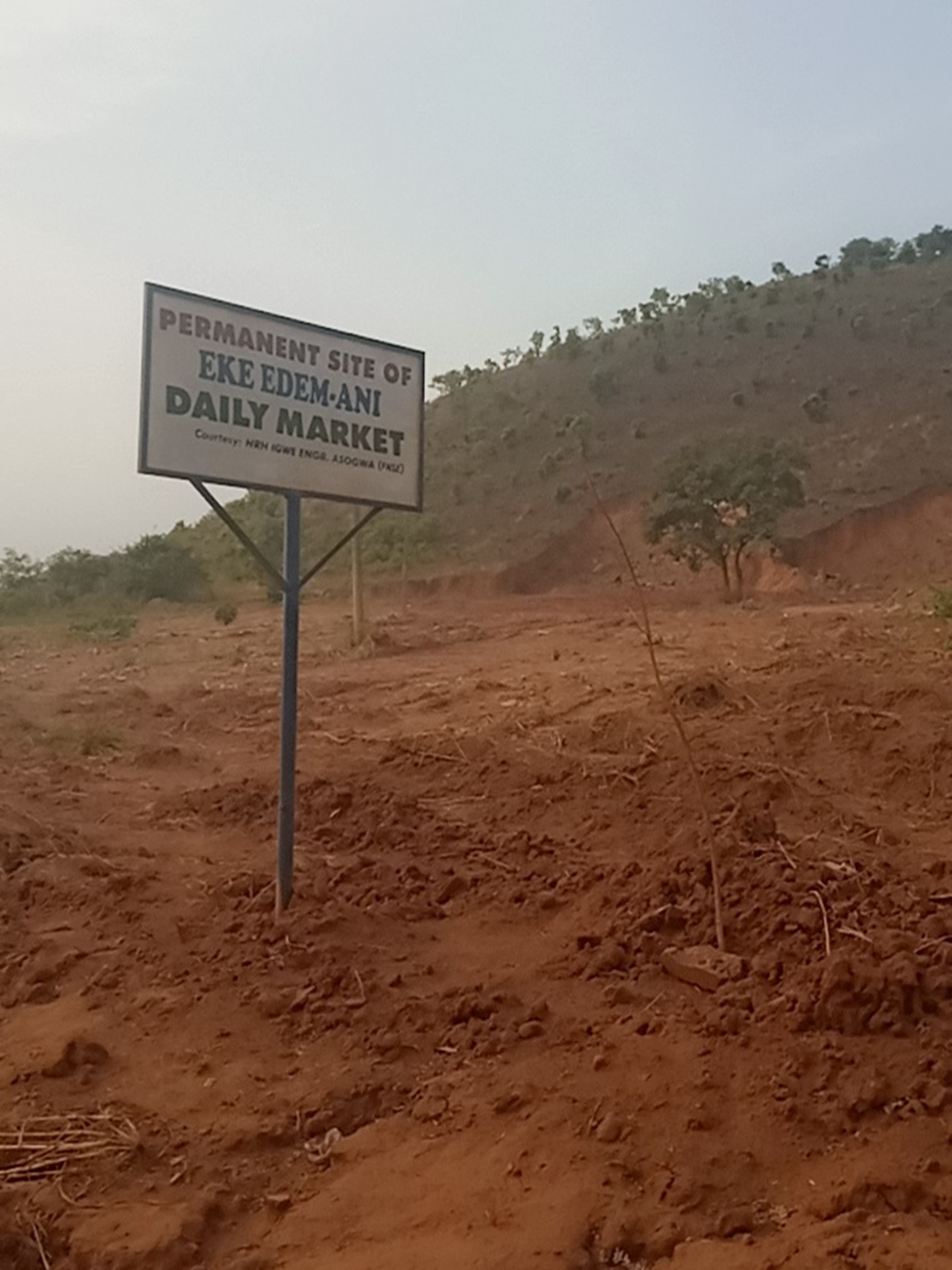
Designated site for Eke Daily Market at the foot of the plateaus in Edem-Ani.
Discussion
The paper has shown the land and territorial conflict between Alor-Uno and Edem-Ani, which occurred in the past and has continues in the present. It shows how the presence of plateaus separating the villages invokes the memories of wars fought and how they use it for seeking legitimation of their claim over the disputed space. The paper’s findings have several implications and connect with many ideas from strands of landscape memory literature. It supports the notion that memory shapes communities’ sensitivity to territoriality and negotiates between belongings and exclusion in land tenure (Shea, 2019), which engenders conflict, as we have seen in the case study. This also connects with the idea that specific landscape imprints signalling supposed territories of different groups and thus essentially establish space, hence ‘affecting access and exclusion’ (Baird, 2014: 64). The presence of the plateaus evokes the ancient wars and contemporary struggles’ memories. They are sites of memory that the communities draw upon to lay claim to the land and seek legitimation of their claim.
Our finding mirrors the idea that memories of past battles influence the land distribution and power relations (Kinsey, 2004). The use of the plateaus as a landscape of identification and territorial boundaries has shaped land tenure, as Edem-Ani now wants to exclude Alor-Uno from using the land because they have had the land for many hundreds of years after the civil wars that plagued Alor-Uno. This speaks to the notion that memories of past land use and tenure are vital for legitimizing access and makes it easy to marginalize the supposed landowners who have not used the area for a long time due to displacement (Baird and Le Billon, 2012) with the changing of land tenure configurations via the making of new boundaries (Baird, 2014: 61). These findings of this study thus inform us that the memory of past land use reinforces the legitimacy of current land tenure configurations and shape sensitivity to territoriality leading to exclusion.
The disputed space between Edem-Ani and Alor-Uno plus the stone assemblages at the plateaus’ top reflect Nora’s (1989) conception of sites of memory that directs our thinking to how ideas of the past are reconstructed in the depiction of places. That space and the stone relics enable the recollection of struggles over dispossession and resistance, as well as socio-political exchanges between victor and vanquished or between settlers and the displaced (Gunner, 2005). Hence, it speaks to the fact that memories of persecution, grief and marginalization can sustain group identities and can come to be lived through across generations translating into a ground for future fighting (Onuoha, 2016), as observed in the study areas section. We found that while the people’s memories of this landscape vary between the two communities, they do not change temporarily. Thus, we found no support for works indicating that the stories that the memories evoke are socially temporal (e.g. Barlow, 2017; Shea, 2019).
Given that land and the significance of plateaus are at the heart of the conflict between Edem-Ani and Alor-Uno, we call for more attention to the non-human agency in connection to landscapes’ political memory. This speaks to dialoguing with literature on the human and nature interactions connected to landscape memory (Harrison, 2015; Ingold, 2005) and particularly in the Igbo society (e.g. Ugwuanyi, 2021). As Ugwuanyi makes us appreciate the Igbo, they live in harmony with Ala (land) and situate all their actions on the land, which establishes human–nature relations that ensure the survival of landscape memories. Taking this argument further, it vital to add that even though the Igbo live in harmony with Ala, and by extension, a landscape, Ala itself produces disputes among the people as we have seen in Edem-Ani and Alor-Uno. As such, we need to also think about the agency of non-human social relations in Igboland. This perspective speaks to the current post-human thinking in human geography that emphasizes the relationality, materiality and agency of non-humans.
In conclusion, landscape studies in Africa need to focus more on this aspect of the landscape found in other world regions (Baird, 2014; Baird and Le Billon, 2012). The continent is replete with intra-state land/border conflict environments. Given that the presence of landscapes reminds people of the past and these memories can differ between communities as well as being a source of conflict as this paper has shown, resource conflicts analysis should take social meanings, memories and identities that are connected to physical landscape seriously as they contain ideological and symbolic elements foregrounding conflict environments. This is equally vital to conflict management and resolution strategies. Not doing this leaves the landscape liable to damage, especially the landscape ecosystem, because of conflict disasters (Taruvinga and Ndoro, 2003).
Footnotes
Declaration of Conflicting Interests
The author(s) declared no potential conflicts of interest with respect to the research, authorship, and/or publication of this article.
Funding
The author(s) received no financial support for the research, authorship, and/or publication of this article.
Data Availability Statement
The research used data from interviews and field observations. Relevant data are included in the paper and available upon request.
Author Biographies
Email:
Email: