
Abstract
Benjamin D. Hennig charts the cables, canals and corridors of a connected planet, and where they could break.
The waters surrounding the Arabian Peninsula have become a vivid illustration of how global political shifts and disruptions ripple through the world economy. Some 12 per cent of global trade, including 30 per cent of global container traffic, passes through this narrow connection between the Indian Ocean and the Mediterranean.
The route was blocked for several days in 2021 when the container ship Ever Given ran aground in the Suez Canal, with the value of goods delayed estimated at up to 10 billion US dollars a day. In late 2023, Houthi rebels began targeting international shipping in the Red Sea in response to the Gaza conflict.
South of the Red Sea, in the Gulf of Aden, modern piracy has been a major challenge emerging from the collapse of Somali state authority. Over the past three decades it developed into a highly organised system of maritime extortion. While international efforts improved regional security for a time, recent years appear to indicate a rebound of pirate activity. Similar concerns remain relevant around Singapore and the Strait of Malacca, one of the busiest maritime passages in the world, where dense traffic and contested waters make any disruption consequential.
The main alternative to the region is the circumnavigation of Africa via the Cape Route, which adds an additional 4,500 nautical miles, or almost 30 per cent extra distance, to the journey from Asia to Europe and takes close to two extra weeks. Southern European ports are even more affected, as added time is needed to reach them within the Mediterranean. This has already pushed up freight rates in recent years, but it has also added environmental costs and represents a setback for global shipping’s progress towards net-zero emissions by or around 2050. Rerouting via the Cape of Good Hope adds an estimated 42 per cent to emissions for each individual vessel.
Such problems are compounded when rerouting is not possible at all. On the other side of the Arabian Peninsula lies one of the clearest recent examples of such a disruption. The Strait of Hormuz between Iran and Oman is a crucial corridor for oil and liquefied natural gas, handling roughly a fifth of global oil supply and most crude shipments bound for Asian markets. More than $600 billion worth of energy trade passes through the corridor in normal times. When conflict involving Iran, Israel and the United States raised the prospect of Hormuz being closed, the consequences moved quickly into energy markets across the world and began affecting the global economy more broadly.
Geopolitical tensions also bear on the Taiwan Strait, which sits at the centre of East Asian manufacturing networks and the semiconductor supply chains on which much of modern electronics manufacturing depends. Because a small number of Taiwanese firms produce the most advanced chips, any military escalation there would have consequences far beyond the region.
Other vulnerable locations include the Panama Canal, which links Atlantic and Pacific economies. Here, climate change adds an environmental dimension to the geopolitical vulnerabilities. The canal’s operation depends on freshwater from Gatún Lake, and has suffered major disruptions through droughts in recent years.
What do such disruptions mean for processes of globalisation? Globalisation is often described through the language of markets, trade agreements, supply chains, migration and digital communication. Yet behind these abstract terms lies a much more material world. As the examples above show, the global economy depends on shipping routes and on many other types of infrastructure that enable connectivity, ranging from roads, railways, ports and pipelines to power lines and submarine data cables.
Beyond tankers passing through narrow maritime corridors and container ships linking centres of production and consumption, globalisation relies on pipelines transporting oil and gas, electricity grids carrying power, and fibre-optic cables carrying the world’s communications across the seabed and over the continents.
The political geography of the era following the Second World War has been shaped as much by these connecting systems as by the borders and political blocs that divide the world. Energy security, food prices, military dominance, internet access and industrial production, all depend on networks that stretch across land and sea.
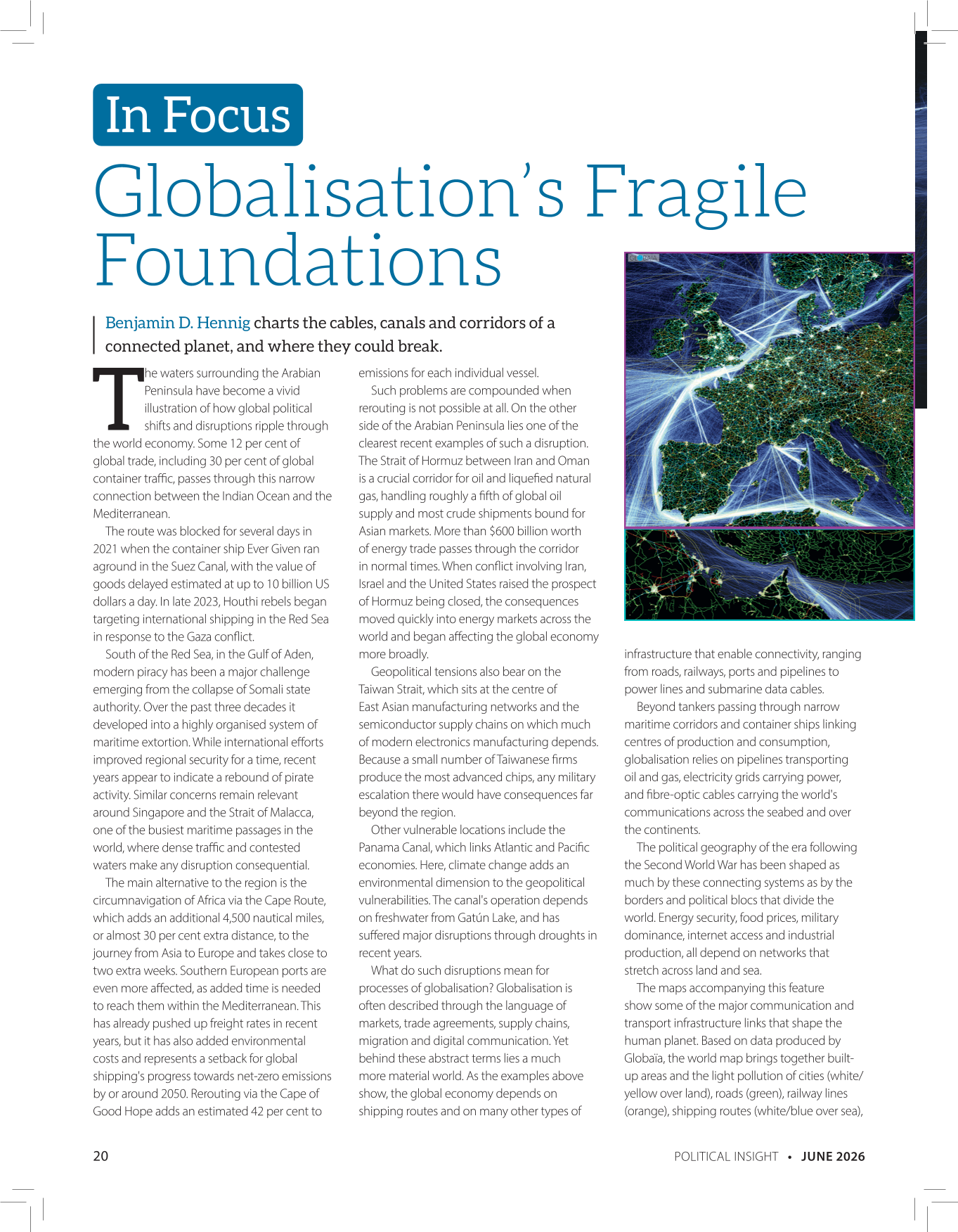
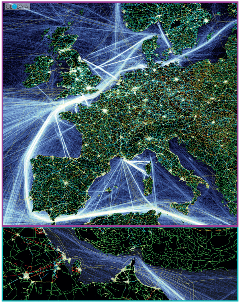
The maps accompanying this feature show some of the major communication and transport infrastructure links that shape the human planet. Based on data produced by Globaïa, the world map brings together builtup areas and the light pollution of cities (white/yellow over land), roads (green), railway lines (orange), shipping routes (white/blue over sea), pipelines (red), transmission lines (blue) and submarine cables (yellow over sea).
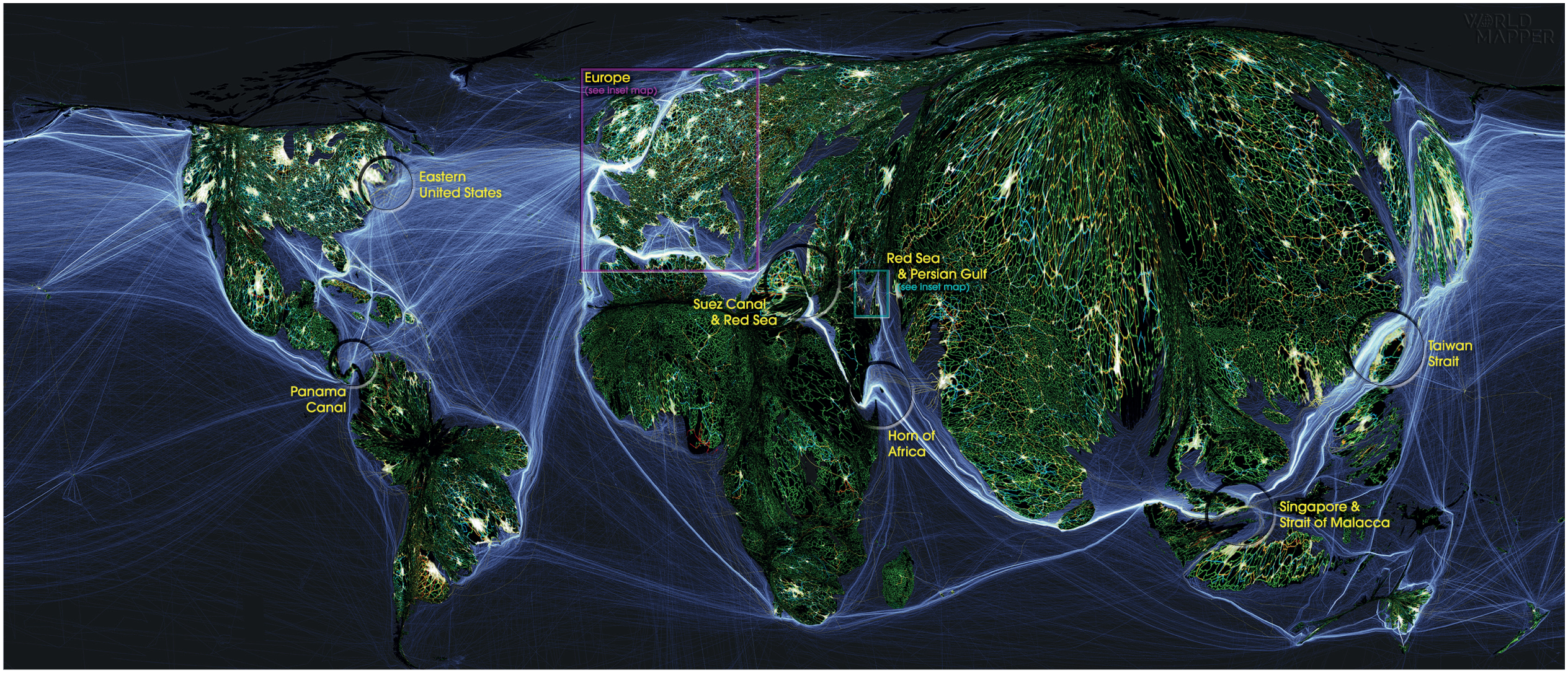
For the global perspective, these connections are shown on a gridded population cartogram as a base map, giving more visual space to the most populated parts of the world while reducing sparsely populated regions. The result is a map of the human planet, in which infrastructure is shown in relation to where people live. It shows that global connectivity is not equally distributed across the world’s population.
Europe, eastern North America, and parts of South Asia and East Asia appear as dense webs of overlapping systems. Cities, roads, railways, power lines and communication routes merge into bright clusters, while the oceans around them are crossed by heavily used shipping lanes. By contrast, large parts of Africa, Central Asia and the interior of South America appear less densely threaded into these infrastructures. This does not mean that these regions sit outside globalisation; quite the opposite. Many are deeply embedded in global systems through extraction, export routes, finance, labour mobility and resource dependency. What differs is the position they occupy within those systems. Some places, predominantly in North America and Europe, are connected as centres of command, exchange and consumption; others as sources of raw materials, corridors of passage, or peripheral nodes in networks organised elsewhere.
The least visible connections are those beneath the sea. Submarine cables carry almost all intercontinental data traffic on which much of the 21stcentury world now relies. Financial transactions, diplomatic communication, scientific collaboration, streaming platforms, social media, everyday messages and much of the globalised economy, depend on these physical infrastructures stretched across the ocean floor. Dense transatlantic cable connections link major data, financial and political centres, such as those running from the eastern United States towards Europe.
This interconnectivity continues across land. Europe is perhaps the most intensely connected region of the world, as shown in the zoomed conventional map in this feature. Dense urban lights merge with closely spaced road and rail networks, especially across western and central Europe, creating an almost continuous infrastructure field from the British Isles through France and Germany into northern Italy. Transmission lines, pipelines, a multitude of undersea cables and shipping routes add further layers to this connected landscape. With no borders shown, Europe appears less as a set of separate national territories than as a compact, highly integrated space of circulation.
European energy infrastructure has also become a central arena of geopolitical vulnerability. Russia’s invasion of Ukraine exposed the extent to which European energy systems had depended on Russian pipeline gas, including flows through Ukraine and other major corridors. The war triggered a major shift in European energy politics: a search for alternative suppliers, increased liquefied natural gas imports, changed storage policies, demand reduction, and renewed concern over the security of pipelines, terminals and grids.
The connections that hold the globalised world together often reproduce older geographies of power. Many of these structures are rooted in the history of colonialism: European imperial expansion laid down trade routes, coaling stations and port hierarchies that still shape how the world connects today. As the post-war order becomes increasingly unsettled, not least since Donald Trump’s second presidential term in the United States, the density and complexity of these connections also create major vulnerabilities.
Globalisation has produced a highly efficient system in which resources, goods and information move across long distances. Yet such efficiency has so far depended on concentration. A small number of corridors, ports, canals, straits, pipelines and cables carry a large share of global movement.
The complexity of this cobweb also means that globalisation cannot simply be undone; the world is unlikely to become less connected. Globalisation has not come to an end, despite the disruptions and vulnerabilities outlined in this feature. Yet it remains to be seen what kind of connected world will emerge from the current period of geopolitical fragmentation, economic nationalism and strategic realignment.
We may see a world with even more concentrated and more polarised flows. Another possibility is a realignment of these patterns, as states, companies and international institutions seek alternative routes, redundant systems, regional production capacities and more diversified supply chains. Whether this leads to a more fragmented and unequal world, or to a more balanced system of global interdependence, will be one of the central political challenges of the coming decade.
Footnotes
Benjamin D. Hennig is Professor of Geography at the University of Iceland and Honorary Research Fellow at the University of Oxford.