
Abstract
This article reports a multi-scale analysis of polycentric urban development in 22 Chinese city-regions. Using fine-grained population data, our analysis contrasts polycentric development patterns at multiple geographical scales. We present a typology of Chinese city-regions based on both (1) their inter-city polycentricity and (2) the intra-city polycentricity of the individual cities that comprise these urban regions. Overall, we find only limited levels of association between inter-city and intra-city polycentricity. The Pearl River and Yangtze River Deltas have high levels of inter-city and intra-city polycentricity. Most city-regions in Central and Western China are characterized by a primate urban system and low levels of inter-city polycentricity. We hypothesize the major economic, political, and geographical processes underlying observed patterns.
Introduction
Over the past decade, polycentric urban development has increasingly attracted interest from academics and policy-makers alike (Hall and Pain, 2006; Musterd and Kloosterman, 2001). In the most general sense, “polycentric urban development” refers to a broad range of processes causing multiple proximately located (parts of) urban centers that were formerly functioning more or less independently to become functionally integrated. In the literature, it is claimed that polycentric urban development could bring about positive externalities and produce an integrated system that is “more than the sum of its parts” (Meijers, 2005). More specifically, polycentric urban development is assumed to produce economically more competitive, socially more cohesive, and environmentally more sustainable urban regions (Hall and Pain, 2006; Parr, 2004). For example, it is believed to encourage economic synergy and specialization, foster compact urban centers and mixed land-use, as well as reduce urban heat islands (Lee and Lee, 2014; Meijers and Burger, 2010; Veneri, 2010).
Ideas about polycentric urban development have also raised considerable interest among policy makers and urban planners. As a consequence, a range of normative plans and policies have been proposed advocating “polycentric urban development”, including the European Spatial Development Perspective, the “planned polycentrism” in Tokyo (Sorensen, 2001) and Seoul (Lee and Shin, 2011), as well as the rise of “megaregions” in the US (Nelson and Lang, 2011). More recently, this quest for polycentric urban development has emerged in China. Li and Wu (2012) have provided a detailed documentation of the rises and falls of city-regional projects in China. Most important for our discussion here is the observation that polycentric urban development in China has been pursued at a range of geographical scales. At the national level, the three dense urban agglomerations around the Pearl River Delta (PRD), Yangtze River Delta (YRD), and Beijing have long been deemed “growth poles” of the national economy. At the inter-city level, city-regions and balanced development among cities of various sizes are emphasized in China’s 13th Five Year Plan for National Economic and Social Development, which was approved in March 2016 in the National People’s Congress, China’s top legislative body. Before appearing in national plans, polycentric city-regions and more specifically synergies and complementarities among multiple centers have featured in regional plans for the country’s more developed Yangtze River and Pearl River Deltas (Li and Wu, 2013). At the intra-city level, many municipal governments have included a “polycentric urban pattern” in their spatial plans (Sun and Wei, 2015). A recent high profile case in point is the designation of a “vice administrative center” in Beijing. While there is a long history of satellite city development in Beijing, this latest episode aims to relocate the municipal government (not the central government of China) from the city center to a satellite town. By relocating the municipal government, its public servants, and related supporting sectors, this plan hopes to partially address the over-crowding issue in the old urban core and instill development into Beijing’s outskirts.
Against this backdrop, this paper reports an exploratory analysis of polycentric urban development in China at both the inter-city and intra-city scales. Our study aims to make the following contributions. First, we seek to extend the literature on the multi-scale nature of polycentricity and provide an integrated assessment of polycentric urban development at both inter-city and intra-city scales. Second, it will contribute to the literature on Chinese cities by comparing polycentric urban forms in 22 Chinese city-regions by means of a consistent dataset. Third, the paper will draw upon insights on Chinese urbanization and conceptualize the dynamics and processes underlying observed multi-scale polycentric urban patterns. Our analysis thus extends the work of Liu et al. (2016) and Liu and Wang (2016), who examined the polycentric spatial structure of 22 major urban regions. The remainder of this paper is organized as follows. The next section reviews the literature on multi-scalar polycentric urban development and presents a brief clarification of empirical approaches to measuring polycentricity. We then elaborate our data and explain how urban polycentricity at both intra-city and inter-city scales is measured. Polycentric development patterns at multiple geographical scales are then empirically contrasted, with references to prior studies, by means of a typology of Chinese city-regions. The paper concludes with a summary of empirical findings, methodological limitations and possible avenues for further research.
Literature review
Multi-scale polycentric urban development
The literature on polycentric urban development is far from consolidated, as evidenced by the diversity of concepts, approaches, and research foci (Meijers, 2005; Van Meeteren et al., 2016). A major element in the academic debate concerns the scale at which “polycentrism” unfolds. As already implied above, the concept of “polycentric urban development” has been conceptualized and pursued at multiple geographical scales (Liu et al., 2016), ranging from the intra-city scale (e.g., employment and population centers within a city), the inter-city scale (e.g., the “Ruhr” and “Randstad” city-regions in the Europe), the regional scale (e.g., multiple growth poles envisioned in the European territorial development plans), to the global scale (e.g., a worldwide city network anchored by a number of global cities).
Polycentric urban development may exert different impacts on socioeconomic development and environmental processes at different scales. Furthermore, the scale at which polycentric urban development unfolds obviously matters, as different spatial scales imply a focus on different policy issues (Brezzi and Veneri, 2015). For example, polycentricity at the intra-city scale is usually linked with job-housing balance and the provision of public services, whereas inter-city polycentricity is commonly associated with “regionalized” agglomeration, “borrowed size”, and industrial specialization (Meijers and Burger, 2015; Modarres, 2011). As empirical studies have mostly focused on one of these scales, in the literature, there is no integrated assessment of polycentric urban development at different scales in general, let alone studies on the interactions between “polycentrism” at different scales (however, see Brezzi and Veneri (2015) for a multi-scalar analysis of polycentricity in selected Organisation for Economic Co-operation and Development countries).
Polycentric urban development in China
During the socialist era, Chinese cities generally remained quite compact, as peripheral areas and satellite towns were relatively underdeveloped (Wu, 2015; Wu and Yeh, 1999). For example, cities were treated as centers of accumulation instead of centers of consumption. Public investment in the core areas was already limited, and satellite towns and peripheral areas were even less serviced. Moreover, socialist cities were organized around state work-units, dan wei, which promoted high level of job and housing balance and helped producing a compact urban form. Furthermore, land and housing markets did not exist. As a consequence, apart from large state industrial towns/plants, urban development in the socialist era was quite constrained in city centers (Hsing, 2010; Wu, 2015). At the inter-city scale, the control of urban population distribution and city size was a spatial planning policy. This control was achieved through the allocation of major state investment and projects as well as the hukou household registration system.
The transition brought by urbanization, marketization, and globalization created conditions for more polycentric urban patterns. For example, driven by strategic plans as well as land-based municipal finance, new towns and districts mushroomed in the outskirts of Chinese cities (e.g., Wu and Phelps, 2011). This emergence of new towns was also propelled by rural transformative development (Lin, 2002). Furthermore, substantive economic development along the Chinese coastal lines has led to dense urban agglomerations consisting of multiple centers.
A great deal of research has tried to conceptualize and identify emerging polycentric urban regions in China at the inter-city scale (Yang et al., 2015). Intra-city polycentricity has been less researched, with the few studies mostly focusing on a few leading Chinese cities, including Beijing, Hangzhou, and Guangzhou (Wen and Tao, 2015; Wu, 1998; Zhao et al., 2011), so that relatively little is known about cities in other parts of the country. A notable exception would be the Pearl River and Yangtze River Deltas. In contrast, the polycentric development of the Pearl River Delta and Yangtze River Delta has been well documented at both intra-city (Wu, 1998; Wu and Yeh, 1999) and inter-city scales (Liu et al., 2016; Wang et al., 2015). However, these analyses oftentimes employ different data sources and methods, thus making their results incomparable. As policies and plans have been proposed to advance “polycentrism” at multiple geographical scales, an integrated assessment would provide a cross-sectional overview and form the basis for future policy evaluation.
Measuring polycentricity
The measurement of polycentricity hinges on the assessment of whether there is a relative balance among proximate centers in terms of their “importance” (Hall and Pain, 2006). In addition to the functional integration of a set of historically independent settlements, the concept of polycentricity emphasizes the lack of a dominant settlement in terms of size and/or economic vitality. Empirical approaches to measuring polycentricity therefore differ in (1) how to approximate the “importance” of individual centers and (2) how to assess the balance of “importance” among centers.
The most common approach is to approximate the “importance” of individual centers by different urban attributes, such as population, employment, and Gross Domestic Product (GDP). However, the examination of “polycentricity” can focus on the attributes of centers (i.e., the morphological aspect of polycentricity) as well as interactions between centers (i.e., functional and relational dimensions; Halbert, 2008). This bifurcation is often said to reflect the more conventional bifurcation between a more classical “urban systems” perspective focusing on the market principle in Christaller-like hierarchies and what has been called the emerging “urban network” paradigm (Camagni and Capello, 2004). In the “urban network” paradigm, the importance of individual centers depends on their connectivity and positions within the network. In addition, “polycentrism” has also been conceptualized and measured through its political dimension (Halbert, 2008; Van Meeteren et al., 2015), where it points to a multi-layered and multi-sector urban governance structure.
While all these perspectives offer different insights about polycentric urban development, most analyses focus on the morphological dimension and assess polycentricity based on the “importance” of individual centers. On the one hand, morphological polycentricity is to a certain extent mirrored in other forms of polycentricity. On the other hand, analyses of political, relational, and functional polycentricity oftentimes require measuring a range of intangible dimensions such as social interactions and power relations. Even if such measures could be found, it is hard to obtain for systematic large-scale studies. For example, functional approaches to polycentricity rely on measuring flows of information, people, and goods. Nevertheless, data about intra-city flows are difficult to be gathered for a large array of cities (Liu et al., 2016; Modarres, 2011). By contrast, it is more straightforward to find measures about urban size at different geographical scales and these measures are usually reported as part of the census exercise.
As for the assessment of the distribution of “importance” among centers, there are three broad categories of empirical methods (Liu et al., 2016). First, drawing on the complex system literature, rank-size based methods measure polycentricity based on the slope of a regression line that summarizes the statistical relationship between the size/importance and corresponding ranks of individual centers (Meijers and Burger, 2010). Second, detailed spatial models have been developed to characterize the distribution of “importance” among urban centers and measure polycentricity by comparing the observed distribution against certain ideal-typical benchmark scenarios (Hanssens et al., 2014; Vasanen, 2012). Third, Green (2007) has advanced a social network-based approach to produce normalized polycentricity indicators based on the standard deviation of (the importance of) individual centers. Compared with previous two approaches, the interpretation of normalized indicators is more straightforward and the approach is less data and computationally intensive. Although this approach is initially proposed to examine interactions among individual centers, it has been extended to study “importance” within centers (Liu et al., 2016). Furthermore, Liu et al. (2016) applied this approach to assess polycentricity for selected Chinese city-regions, thus providing a useful benchmark for the current analysis. Therefore, this paper will attempt to extend polycentricity measures employed in Liu et al. (2016) and gauge morphological polycentricity at multiple scales.
Data and methods
Study area
Our analysis will focus on the 22 Chinese city-regions (Figure 1) identified in Fang et al. (2010). The same selection of city-regions has been adopted in Liu et al. (2016), thus allowing for inter-study comparisons. The definition of these city-regions considers both regional plans initiated by the (central) government (Li and Wu, 2013) as well as relative intra-regional cultural, social, economic, and environmental homogeneity. Most of these city-regions feature in China’s 13th Five Year Plan for National Economic and Social Development. Furthermore, the State Council has approved the plans for several city-regions in our study. The most recent example is the plan for the Harbin–Changchun city-region which was approved in February 2016. The 22 selected city-regions are of high importance in China’s territorial development strategies: they collectively account for 47% (151/321) of all Chinese cities at the prefectural level and above, occupy 20% of China’s land area, host 55% of the total population, and produce nearly 80% of national GDP (Liu et al., 2016). The names of these city-regions are given in Fang et al. (2010), and we have provided translations and three-letter codes for international readers. These translations and codes adopt international conventions and refer to well-known cities whenever possible.
Location of the 22 city-regions under investigation (codes for city-regions are detailed in Table 1; cities at prefectural-level and above are visualized; Fang et al., 2010).
Most importantly, our intra-city level analysis examines the spatial structure within a Chinese city, while the analysis at the inter-city scale focus on individual cities that comprise selected city-regions. Cities in our discussion correspond to municipalities at the prefectural level and above featuring in our selected city-regions (Li, 2014).
Data
The lack of studies featuring inter-scalar comparisons can be partly ascribed to the dearth of fine-grained data about Chinese cities. To circumvent this issue, we employ the LandScan High Resolution Global Population Dataset (Dobson et al., 2000). Coherently combining various data sources, the LandScan dataset provides fine-grained global population coverage at 1 km scale. Although the LandScan algorithms are still within patent protection, the errors in population estimation seem to be reasonable; LandScan data have been widely applied and in some studies even treated as the “ground truth” of population distributions (Bhaduri et al., 2007).
Furthermore, gridded/raster LandScan data are suitable for a multi-scale analysis of polycentricity (Ratti and Richens, 2004). First, most census data are reported at aggregate levels, making it difficult to study intra-city polycentricity. For example, GDP and population figures for individual districts within a Chinese city are usually hard to obtain. By contrast, LandScan provides population estimates in fine-grained grids, thus allowing us to “open the black box” of intra-city urban spatial structure (Brezzi and Veneri, 2015). Second, census and other official data are often affected by changes in the administrative system. For example, county annexation, the creation of new development zones, and the redrawing of administrative boundaries can all change the spatial delineation of census units (Zhang and Wu, 2006). By reporting population estimates in grids, LandScan avoids these issues and enable longitudinal comparisons. LandScan data for this analysis are gathered for the year of 2013.
We note that our analysis only represents one specific attempt at measuring polycentricity based on the spatial distribution of population. Other analyses using different urban attributes and variables may or may not generate the same results. For example, our LandScan-based approach can identify population centers, but these do not necessarily coincide with other types of urban centers, such as transport and employment centers. Nevertheless, a focus on population centers is relevant within Chinese administrative and planning systems (Li, 2014). For example, per capita standards (of built-up land and public service) are still used in devising planning targets. In addition, hukou and other population control measures are still important policy tools, and plans to cap/redistribute population in leading cities such as Beijing and Shanghai are fiercely debated. Hukou is a household registration system in China which officially identifies individuals’ urban/rural residence and determines the eligibility for certain services. More relevant for our focus here, hukou serves as a government tool to regulate domestic migration and allocate resources and services in different areas. Although hukou has been gradually relaxed, it still bears long-term effects on population migration and social mobility (Chan, 2009).
Methods
Our empirical method extends the one reported in Liu and Wang (2016) and consists of three major steps.
Identification of population centers
A first step involves identifying population centers at the intra-city scale. Centers in our analysis are defined as a cluster of population grids that are significantly denser than their surroundings (Leslie, 2010). For individual cities, we begin by identifying densely populated LandScan grids. The 5% most densely populated grids in a city are selected for subsequent analysis. This is achieved by creating a density profile for individual cities, within which individual grids are ranked based on their population density. In line with related literature on urban spatial structures (e.g., Giuliano and Small, 1991; Lee, 2007), we are setting a (minimum) density cutoff at the level of the corresponding city’s 95-percentile gridded population density. This cutoff is altered to 90-percentile for Beijing, Shanghai, Guangzhou, Shenzhen, and Tianjin, as these cities’ density profiles are statistically different from those of other cities and a lower threshold can help to capture such difference (Liu and Wang, 2016). Once identified, significantly dense population grids that are adjacent to each other (i.e., rook contiguity) are combined to form clusters. We then define “centers” as those clusters of grids that contain more than 100 thousands inhabitants and cover at least 3 km2 (i.e., three grids).
Figure 2 demonstrates the intra-city population centers identified in four selected city-regions. Our method successfully identifies major urbanized areas within a city (at the prefectural level and above). These identified population centers include the core urban districts as well as outlying urbanized areas such as county seats, county-level cities, and new towns (The most clear-cut example is Figure 2(a) of the Yangtze River Delta). In this sense, the identified patterns of population centers may also shed light on the “scale of administration” in China (Hsing, 2010).
Selected city-regions and identified intra-city population centers: (a) Yangtze River Delta (YRD); (b) Central Guizhou (CGZ); (c) Eastern Hubei (EHB); and (d) Central Plain (CPL).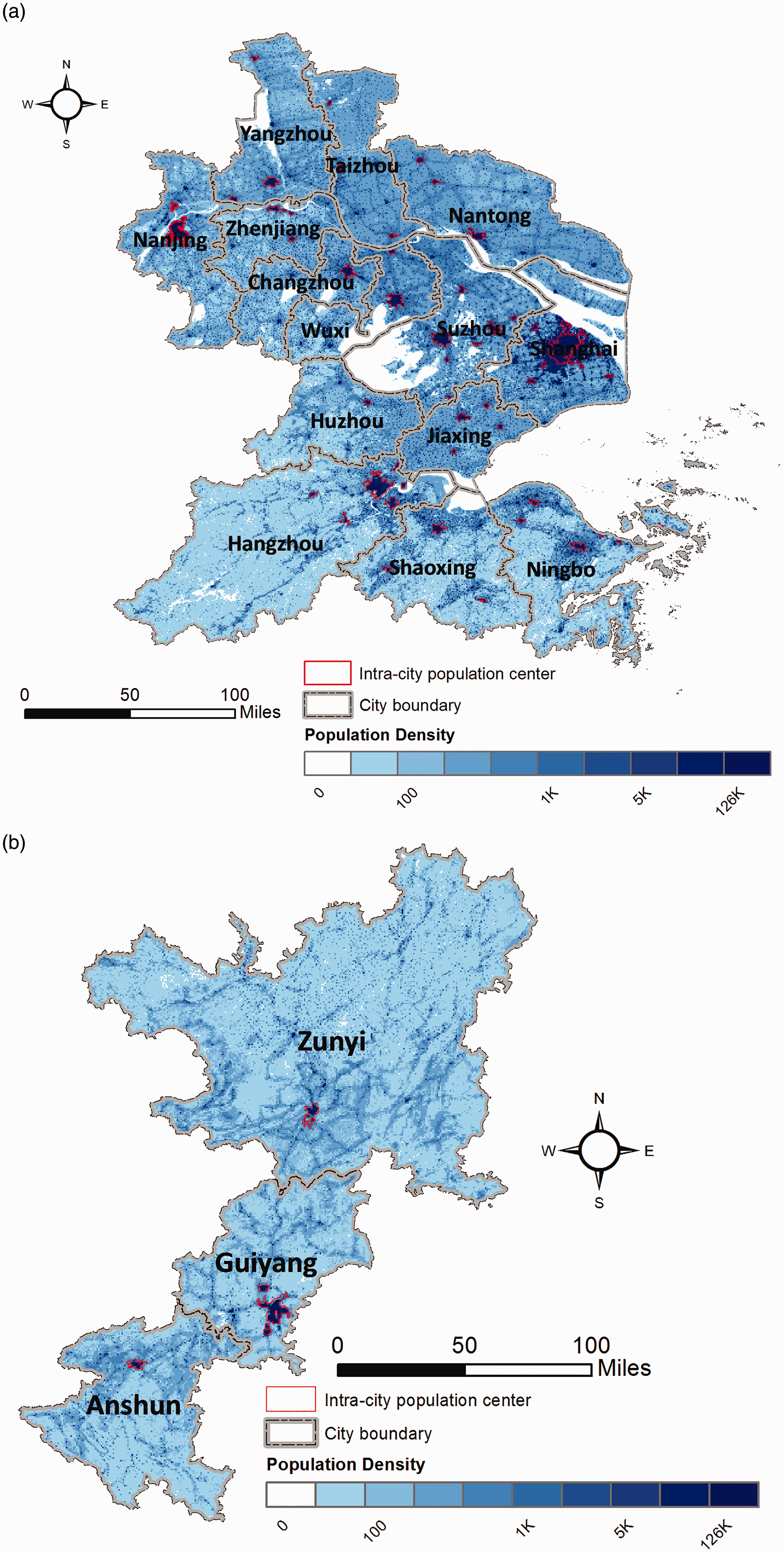
Intra-city polycentricity
Once individual population centers are identified, intra-city polycentricity is measured based on the standard deviation of (the size of) centers (Green, 2007)

Inter-city polycentricity
Inter-city polycentricity is calculated in a similar fashion and summarizes the size distribution of individual cities within a city-region. For individual cities that comprise a city-region, their “importance” is approximated by the sum of population in intra-city centers identified in the previous step. The polycentricty of a city-region is therefore defined as

Basic socioeconomic facts of selected city-regions (Fang et al., 2010; Liu et al., 2016).
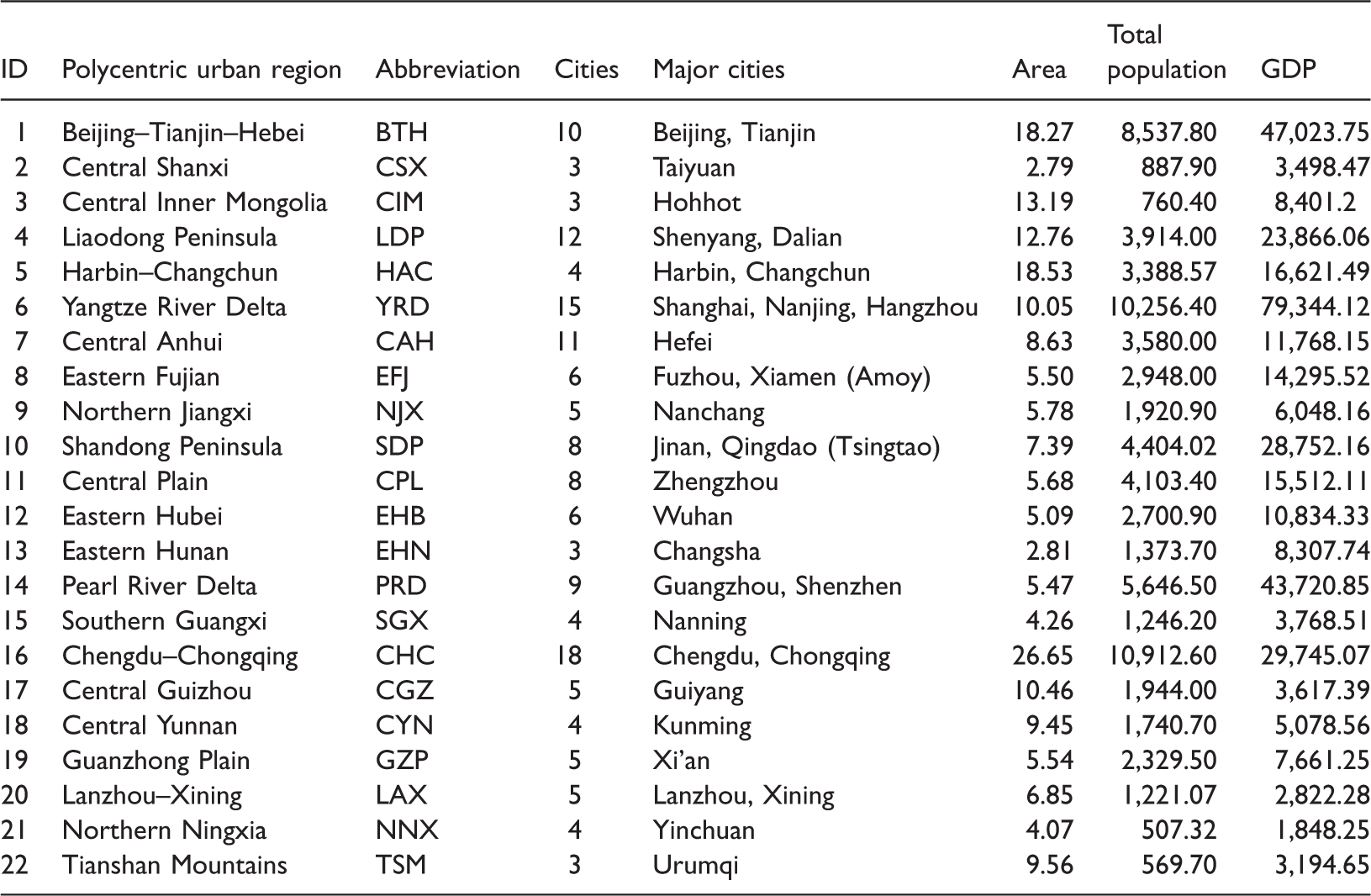
GDP: Gross Domestic Product.
Area in 10,000 km2; Population in 10,000 people; GDP in billion Chinese RMB.
Results
Overview
Inter-city and intra-city polycentricity.
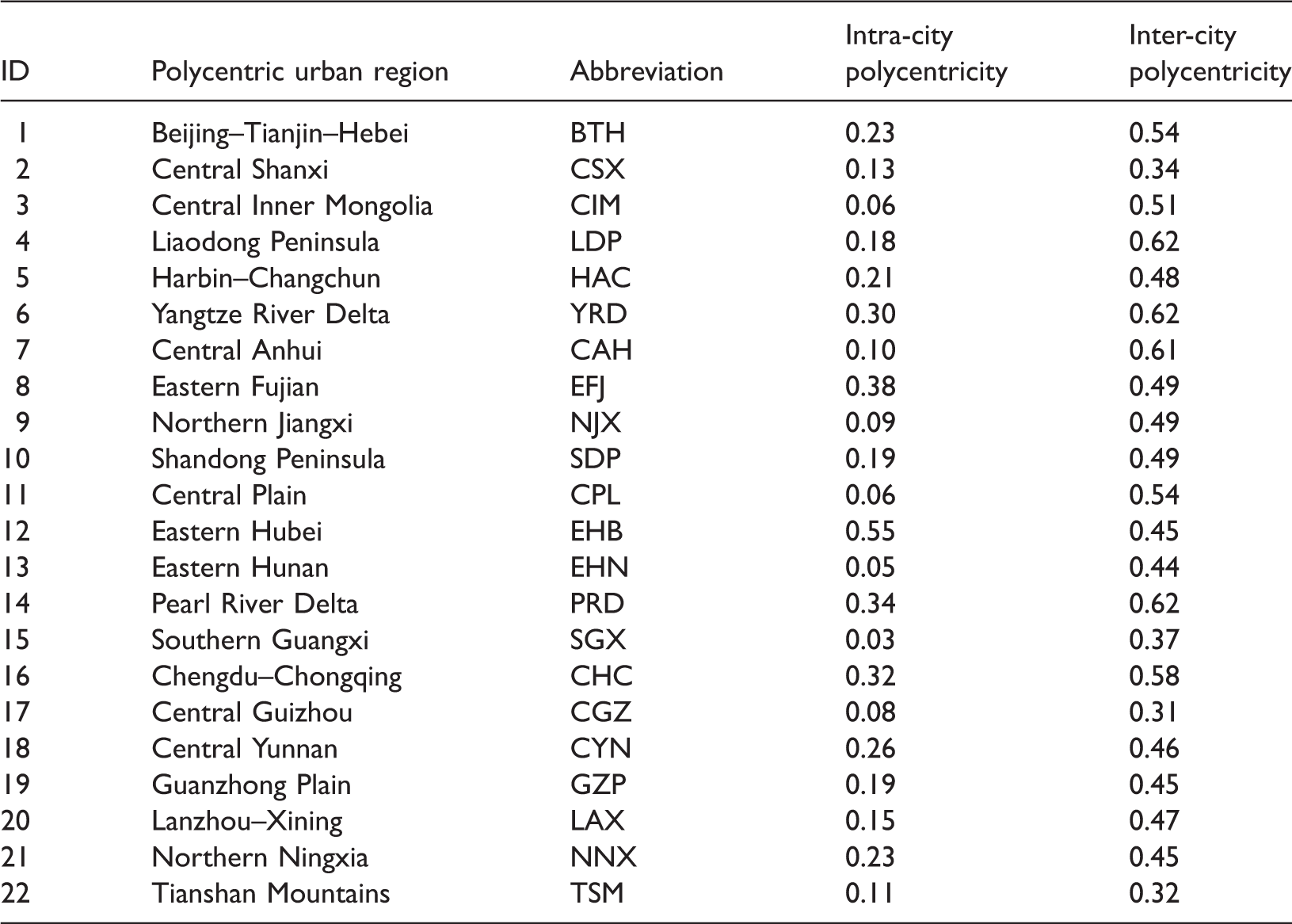
Polycentric measures range from 0 to 1, with 1 indicating complete polycentricity and 0 total absence of polycentricity.
We conjecture three major sets of processes underlying these variations. First, uneven polycentric urban development is largely conditioned on different levels of economic development. During the socialist planning era, city size and the urban system were controlled through state project approval and population control, oftentimes producing a relatively hierarchical pattern among neighboring cities. The economic transition brought by urbanization, marketization, and globalization created conditions for more polycentric urban patterns. At the inter-city level, in addition to the opening and reform policies, convenient locations, mercantile traditions, and foreign economic connections (mostly based on kinship connections with overseas Chinese) all helped to spur substantive economic development along the Chinese coastal lines (Ma and Lin, 1993; Peck and Zhang, 2013), fostering dense urban agglomerations consisting of multiple centers. At the intra-city level, this trend could be evidenced by the emergence of small towns and cities through rural transformative development (Lin, 2002). However, the transition might not be straightforward and one-directional. For example, Lin (2015) notes that while rapid urban expansion and rural urbanization have been the theme in the 1980s, growth in 1990s focusses on large cities and recent trends highlight redevelopment in city centers.
Second, the state remains powerful in shaping urban form at different scales through various state projects and state strategies (Huang et al., 2016). More specifically, the Chinese state could influence the pace and direction of urban development through its planning authority, land ownership and lease market, control of migration, designation of favorable policies, as well as direct investment (Hsing, 2010). On the one hand, state spatial strategies have been employed to promote polycentric urban development, most notably through city-region plans and new town/district development. For example, driven by strategic plans as well as land-based municipal finance, new towns and districts mushroom in the outskirt of Chinese cities (e.g., Sun and Wei, 2015; Wu and Phelps, 2011). At the inter-city level, both local and central governments have mobilized for city-regional cooperation and “a more balanced urban system” (Xu, 2008). In other words, the (re)surgence of city-regional projects reflects the interactions among governments as well as the interactions between state and market (Li and Wu, 2012). Although the effects of city-regional cooperation remain to be tested, and cities may well use cooperation towards a competitive end (Wu, 2015). On the other hand, reforms in territorial governance (e.g., administrative annexation and merger; province-leading-counties reform; as well as assigning higher administrative ranks; Li and Wu, 2013) could re-organize state functions and affect urban spatial patterns. For example, Wuhan, the capital of Hubei province, has one of the most “polycentric” urban patterns at the intra-city level (Liu and Wang, 2016), and this can largely ascribed to the fact that the city was formed by three formerly independent cities through administrative orders in the 1950s. But at a more profound level, institutional and legal reforms such as “integrated urban and rural development”, the establishment of land market, and development/land quota, have created conditions for urban expansion, new development zones, and new towns (Wu, 2015). Nevertheless, while a “state-led urbanization” perspective correctly highlights the central role of governments in shaping urban patterns, Hsing (2010) suggests an alternative “urbanization of the local state” thesis. In other words, urbanization and related politics become an integral part of (local) state building, define the relationships between the state, market, and society as well as relationships between various state actors.
Third, geography matters. Cities in more rugged and fragmented landscape are more likely to develop a polycentric urban pattern (Schneider and Woodcock, 2008; Taubenböck et al., 2009). Nevertheless, this does not necessarily suggest geographic determinism, as development programs have oftentimes little regard for natural conditions and/or strived to transform landform. Examples abound and range from the creation of “third frontier” cities in the mountainous West in the 1960s to the more recent large-scale land development by leveling hills and filling valleys (Li et al., 2014; Liu and Li, 2014). While the identified processes could help explain a great deal of the observed polycentric patterns, we acknowledge that these processes are by no means exhaustive, as other factors such as cultural inertia and multi-level governance may well influence polycentric urban development (Chapman, 2011; Xu, 2008).
A typology of city-regions based on inter-city and intra-city polycentricity
In order to categorize how these three major processes affect individual city-regions, we devise a typology based on their levels of inter-city and intra-city polycentricity of individual city-regions (Figure 3). Individual regions are plotted as circles with their polycentricity scores as coordinates. The position of an urban region reflects the region’s inter-city (x-axis) and intra-city (y-axis) polycentricity. The size of circles corresponds to urban regions’ GDP, and the color reflects the average distance (in km) among cities that comprise the corresponding city-region. A darker color denotes geographical clustering of cities, and vice versa. Centering on the point with mean values of inter-city and intra-city polycentricity, Figure 3 consists of four quadrants.
Intra-city and inter-city polycentricity of selected city-regions.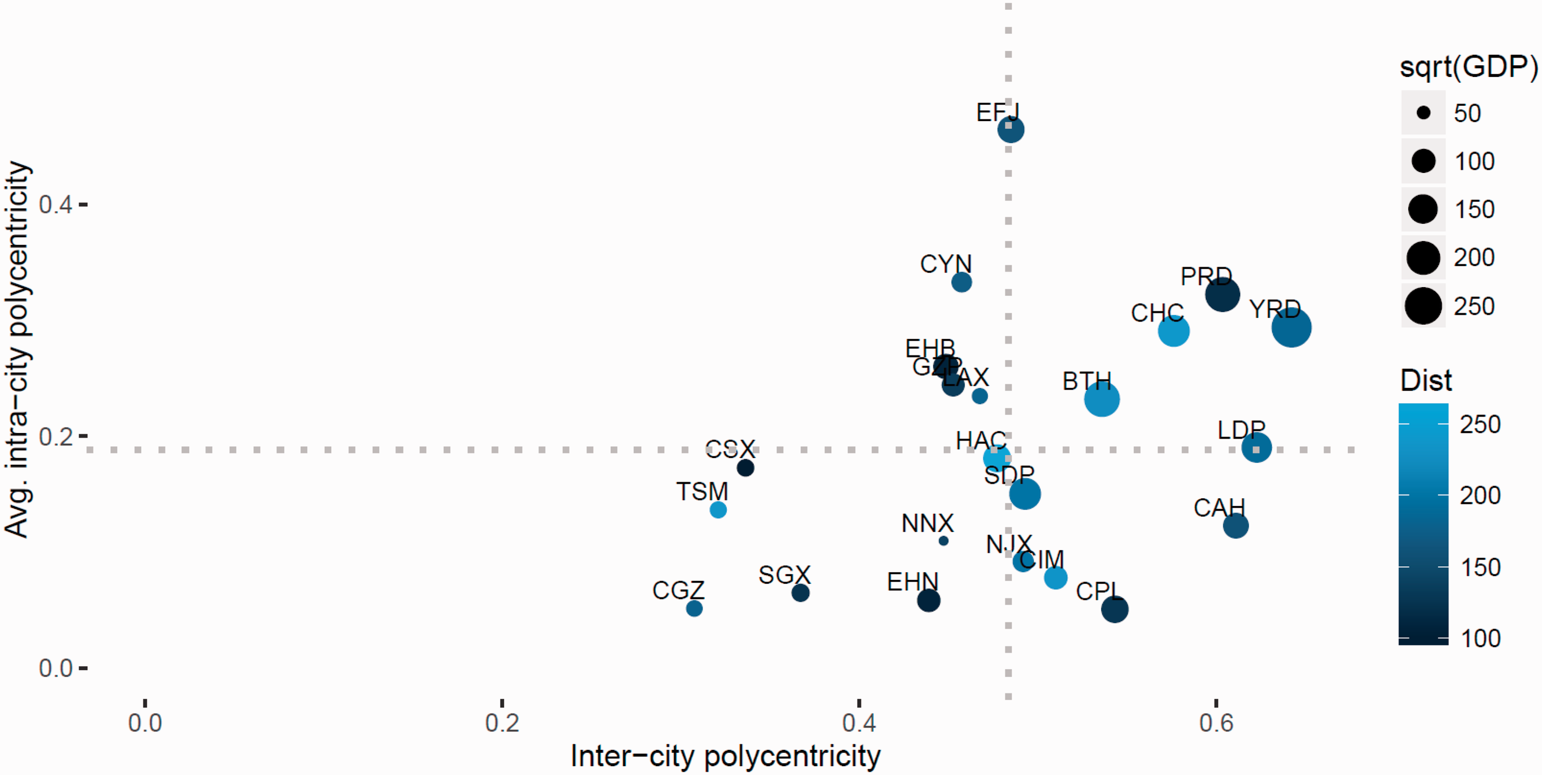
Upper right quadrant
Three coastal urban regions (YRD, PRD, and Beijing–Tianjin–Heibei (BTH)) and one urban region in Western China (Chengdu and Chongqing) are polycentric at both inter-city and intra-city level. A great deal of this observed multi-scale polycentricity could be explained by regional development disparities. At the inter-city level, the Pearl River and Yangtze River Deltas manifest high levels of polycentricity in line with the economic development of their comprising parts (Liu et al., 2016; Zhao et al., 2017). For example, four prefectural-level cities from the Pearl River Delta (Guangzhou, Shenzhen, Foshan, and Dongguan) ranked in the top 20 nationally in terms of GDP in 2013. Though often characterized by intense inter-city competition (Wu and Zhang, 2007), the YRD and PRD were among the very first city-regions to have centrally initiated plans as well as locally coordinated development forum/platforms. These more developed city-regions along the Chinese eastern seaboards have experienced more intensive decentralization and marketization processes.
At the intra-city scale, a more polycentric urban pattern could develop as the by-product of political and economic reforms (Chan and Hu, 2003). On the one hand, the transformed institutions of land management, tax-sharing, public service provision, and cadre promotion have spurred entrepreneurial urban governance and land-based municipal finance in Chinese cities (Lin, 2002). As land assembling is less costly in the outskirts, land-driven development oftentimes results in suburban and “edge city” development and leads to a polycentric urban spatial structure (Wu and Phelps, 2011). This often takes the form of “development zones” in the 1990s, which are designed to foster industrialization, attract foreign investment, facilitate technology transfer, and boost local economies. Yeh and Wu (1996) suggest that there are at least 6000 development zones in China by 1993. Since the 2000s, the focus of development at the urban fringe has been shifted away from industry-oriented development zones and turned towards new towns (notably university towns) that entail a mixture of residential, education, and commercial space (Hsing, 2010). Despite their different size, driving forces, and actors involved, both new development zones and new towns have contributed to urban growth in the urban fringe. Functionally, these developments serve as investment and financing platforms. Not all new town/districts will be successful and the worst scenario can be “ghost towns” (Batty, 2016). Furthermore, inter-city competition has accelerated the pace of land-driven development.
On the other hand, the decentralization of economic decision making, including policies related to “Town and Village Enterprises” (TVEs) and Foreign Direct Investment, often encourages in situ urbanization (Wang et al., 2015). This transition is captured by the TVEs policies’ catchy and often quoted slogan “li tu bu li xiang, jin chang bu jin cheng”—”leave the land but not the village, enter factories but not cities” (Zhu, 2000). The development of TVEs would therefore foster the emergence of small cities and towns in what were formerly suburbs and/or rural counties, which naturally lead to a more polycentric urban pattern and have even drawn parallels to the “Desakota” phenomenon (Shen and Ma, 2005).
Furthermore, the high intra-city polycentricity for cities in this category could be promoted by urban spatial development strategies. Plans can facilitate the conversion of rural lands and help shaping directions for future urban growth. Polycentric urban form has featured in both statutory master plans and strategic plans. For example, the Shanghai master plan has highlighted one urban core and nine satellite towns (Figure 2(a); Sun et al., 2010; Zhao et al., 2011). Still, the Guangzhou Concept Plan in 2000 has envisioned to transform the monocentric urban spatial structure to a polycentric one and provided new directions for future expansion. Another early strategic urban plan in China, the Hangzhou Concept Plan in 2000, has also proposed “a cluster of cities” within the metropolitan area (Wu and Zhang, 2007).
Lower left quadrant
City-regions in this quadrant have relatively low levels of intra-city and inter-city polycentricity. Most of these city-regions are in the economically lagging Western and Central parts of China (Fan and Sun, 2008). At the inter-city level, the observed low polycentricity is consistent with the fact that these city-regions usually have a primate urban system. In other words, a typical city-region in this category consists of a principal city where people, businesses, and favorable policies concentrate, and a number of “peripheral” or secondary cities. These principal cities are usually provincial capitals and examples include Guiyang in the central Guizhou (CGZ; Figure 2(b)) urban region and Urumqi in the Tianshan Mountains urban region. Similar to the situations faced by primate cities in many developing countries (e.g., Buenos Aires in Argentina and Cairo in Egypt), these leading cities are in a better position to receive favorable policies and “coordinate” development within respective city-regions.
These leading cities are relatively well endowed with transportation and telecommunication infrastructures, thus having better chances for industrial upgrading (Suárez and Delgado, 2009). A case in point is the much touted big data and “Internet Plus” industries in the mountainous Guizhou province. The Guizhou provincial government has identified big data and Internet, both of which are supposedly “flattening” technologies, as the key drivers for the province’s future development and poured in resources to set up soft and hard infrastructures. Nevertheless, most of these activities and events, such as the International Big Data Expo 2015, and Global Big Data Era Summit, are concentrated in the provincial capital Guiyang, thus potentially widening the gap among cities in the central Guizhou city-region (CGZ). Furthermore, while rural industrialization has helped narrowing the rural-urban gap in the more developed coastal provinces (e.g., PRD and YRD), the divide between urban centers and surrounding rural areas/outlying towns has been growing in the 2000s in other parts of the country (Hsing, 2010), contributing to monocentric urban patterns at the intra-city scale.
Upper left quadrant
At the inter-city level, city-regions in this quadrant and those in the lower left quadrant suffer the same kind of “primate regional urban system” syndrome (Berry and Okulicz-Kozaryn, 2012; Henderson, 2002). Even when regional policies are devised to promote balanced regional development, the net benefits are usually still concentrated in the leading cities. For example, the plan for central Yunnan city-region envisions a spatial structure featured by “one core, two (development) axes, three circles” (“yi he, liang zhou, san quan”). By designating Kunming as the “core” in this plan, it could further cement the provincial capital’s economic dominance in the region. Similarly, Wuhan’s leading role in the nine-city eastern Hubei city-region is reflected by the corresponding plan’s nickname, “Wuhan 1 + 8 city-region”. Still, the draft plan for the Guanzhong Plain city-region, Shaanxi Province envision to build a territorial structure that has “one (development) axis, one ring, and three corridors” (“yi zhou, yi huan, san zou lang”), all of which converge on the provincial capital, Xi’an. Moreover, recent empirical analyses indicate that urban development tends to concentrate in the leading cities (Hu et al., 2013).
In addition to the urban–rural divide identified above, the high levels of intra-city polycentricity is usually influenced by cities’ fragmented internal geography (Schneider and Woodcock, 2008). For example, the city of Wuhan was forged by three formerly independent municipalities (Jiao, 2015), which are in turn separated by the Yangtze River and its largest tributary, the Han River. Similarly, Lanzhou in the Lanzhou–Xining city-region is known for its dumbbell-style urban form, which stretches for about 60 km along the Huang River valley. Furthermore, the combination of mountainous areas, large urban administrative areas, and resource-led economy has contributed to relatively high intra-city polycentricity for cities in central Yunan (Figure 2(c)).
Lower right quadrant
Urban regions in this group are associated with above-average inter-city polycentricity but below-average intra-city polycentricity. At the inter-city level, these city-regions are oftentimes anchored by several major cities of similar population size, leading to a high inter-city polycentricity score. For example, in the Shandong Peninsula city-region, the provincial capital, Jinan, and the economic powerhouse, Qingdao, have about seven million inhabitants. Similarly, both Hohhot (the provincial capital) and Baotou (an industrial base) in the Central Inner Mongolia city-region have close to two million residents in identified population centers. At the intra-city level, we conjecture that the plain landscape facilitates the formation of large central urban districts and thus suppresses intra-city polycentricity. For example, our analysis identifies only one population center (i.e., mono-center) for five out of the eight cities in the central Plain city-region (Figure 2(d)).
Conclusions
The emergence of polycentric urban patterns in China is the result of interactions between a broad range of processes and dynamics at global, regional, and local scales. While there is a long line of research examining “polycentrism”, to date, there has been no integrated assessment of polycentric urban development at different scales in general and for Chinese cities in particular. Aiming to help fill this void, this paper reported on a multi-scale analysis of polycentric urban development in China. More specifically, using fine-grained population data, our analysis contrasts inter-city and intra-city polycentricity and produces a typology of Chinese city-regions along these two dimensions.
We hypothesize three major sets of processes for these observed variations: uneven economic development; the role of state in shaping the urban landscape; and geographical conditions. Different combinations of these processes produce variegated polycentric urban patterns across China. Our analysis finds little direct correspondence between polycentricity at inter-city and intra-city scale. As governments increasingly identify “polycentric urban development” as an important policy tool to achieve inter alia balanced regional development, our analysis suggests that policies and plans advancing “polycentrism” should be made within reference to specific geographical scales, and should account for potential interaction effects across scales.
While our analysis provides a horizontal overview of polycentric urban development across Chinese cities, the study can be enriched by in-depth case studies that examine how the identified processes unfold in specific localities. These case studies could shed light on the aspirations, strategies, and goals of residents, businesses, and governments that help shaping (polycentric) urban patterns. On the analytical front, our methods can be improved as follows. First, our analysis draws upon intra-city population centers, and as discussed above, analyses looking at other urban centers (e.g., employment clusters and transport hubs) could generate new and nuanced understandings of polycentric urban development. Furthermore, here, we have considered polycentricity in morphological terms and analyses that examine functional and political polycentrism may or may not come to similar conclusions. Second, since almost a decade has passed since the first centrally initiated plans for polycentric urban regions (Li and Wu, 2013), a longitudinal analysis could help evaluating the impacts of these plans. We note that such plan evaluation will undoubtedly need to account for geographical, political, and economical variables. Third, as there is no strict correspondence between inter-city and intra-city polycentricity, future studies of the impacts of polycentric urban development should explicitly incorporate the spatial scale at which hypothesized economic, social, and environmental processes take place. We hope that our analysis could provide a useful starting point for these future endeavors.
Footnotes
Declaration of conflicting interests
The author(s) declared no potential conflicts of interest with respect to the research, authorship, and/or publication of this article.
Funding
The author(s) disclosed receipt of the following financial support for the research, authorship, and/or publication of this article: This study is supported by grants from the National Natural Science Foundation of China (41501177), Hong Kong RGC/ECS (27604016) and Hui Oi Chow Trust Fund (201502172005). The usual disclaimer applies.