
Abstract
This paper explores how an interpretive case-based research strategy can reveal new empirical and theoretical insights into microclimate design. Innovative fieldwork in Christchurch, New Zealand investigated the nature and social meanings of urban comfort in a city with a seasonal climate featuring microclimatic variability, and with a physical landscape undergoing rapid change following a series of major earthquakes. Ethnographic methods were combined with microclimate measurements in four Christchurch-based case study locations to identify ways in which people adjust their cultural and lifestyle values and expectations to the actual microclimatic conditions. The field investigation had to capture data relevant to the microclimatic variability and be suitable for rapidly changing urban settings. Results suggest this integrative methodology successfully adapts to challenging physical contexts, and is able to provide a coherent body of evidence. Important insights revealed through this methodology may not have become apparent if only conventional microclimate methods were used.
Introduction
Innovative approaches to microclimate design will become more important as the world’s population becomes even more urban, and climate change generates more extreme weather conditions in cities (UN-Habitat, 2011, 2016). However, climate responsive design is rarely applied to everyday practice, as professionals involved in implementation processes frequently do not possess sufficient knowledge about the topic (Ryser and Halseth, 2008). Most scientific effort to date has been upon making people comfortable in urban spaces using the outdoor thermal comfort concept, which considers ways that urban microclimate may affect and be affected by a wide range of weather and human factors (Brown, 2010; Givoni et al., 2003; Jendritzky and de Dear, 2009; Stathopoulos et al., 2004). This has established that comfort zone (for both indoors and outdoors) sits between approximately 15 and 25℃ (Olgyay, 1963: 17), but varies across countries. More recent research has investigated the relationship between outdoor thermal comfort and environmental psychology. These studies focus on the human experience of thermal environments revealing new ways of approaching outdoor thermal comfort (Lenzholzer and Brown, 2016). Collective cultural meanings of climate, weather, and place that affect people’s open spaces activity are also essential to understand thermal comfort and adaptation meanings, but have not yet been sufficiently explored.
The goal of this study was to identify relationships between socio-cultural and physical environments that enhance urban comfort and are important in designing liveable cities. Specifically, it is aimed to understand urban comfort in Christchurch, New Zealand. Urban comfort is defined as the socio-cultural (therefore collective) adaptation to microclimate due to satisfaction with the urban environment (Tavares, 2015). The proposition is that humans adapt to microclimate conditions in urban public spaces when they have social and cultural reasons to do so. These reasons, however, are variable across cultures, locality, and past experiences. The interpretive and adaptive research reported in this article investigates combined aspects of urban sociology and human thermal comfort in public open spaces, and considers human capacity to adapt to diverse urban microclimates as a socio-cultural process.
An unusual feature of the study is the rapidly changing urban environment due to a major earthquake that happened during the initial phases of the investigation. This heightened the need for both subjects and researchers to adapt to emerging urban conditions, as well as to a changeable seasonal climate. This combination of circumstances makes the methodology relevant to a wide range of urban settings.
Research design: Interpretive, integrative, and adaptive methodology
This study investigated relationships between urban lifestyle, regional identity, and urban microclimate combined with a rapidly changing urban environment using an interpretive, integrative, and adaptive approach. An interpretive strategy based on case studies was chosen as a way of understanding a complex and meaningful phenomenon, within a rich landscape context (Housley and Smith, 2011; Yin, 2013). Ethnographic methods, including participant observation and in-depth interviews, were undertaken in several inner urban locations. The study was also integrative as it used a multi-method approach combining ethnography with microclimate studies. Microclimatic data were measured and compared to general human activity patterns in the case study sites and to people’s experience of weather.
An adaptive approach to the research was both necessary and appropriate due to the post-earthquake environment. The investigation started soon after the February 2011 Christchurch earthquakes, and aftershocks continued throughout the 18 months of fieldwork (October 2011 to April 2013). Large parts of the city centre were closed, temporary sites were opened, buildings demolished and others underwent significant renovations. The urban condition required what Tøsse (2014: 25) describes as ‘sensemaking’: ‘when an activity is interrupted by something new that needs to be interpreted, acted upon, accommodated, or disregarded’. This situation demands a consideration both of identity and context to understand the phenomenon being investigated. These challenging conditions required a research approach that responded to changing circumstances and new opportunities. It stimulated the development of a robust and adaptable methodology relevant to urban environments undergoing rapid change due to disaster, climate change, or socioeconomic transitions.
Case study: Christchurch New Zealand
Christchurch is the largest city in New Zealand’s South Island, with the country’s second largest urban population of 341,469 residents (Statistics New Zealand, 2013). Christchurch has a temperate maritime climate, protected from westerly winds by the Southern Alps, and with a relatively low mean annual rainfall (Wilson, 2016). The summer mean daily maximum air temperatures range from 20℃ to 22.5℃ but may reach more than 30℃. Winters are cold and below zero temperatures are common in the night with frequent morning frost and mean daily maximum air temperatures between 11℃ and 14℃ (NIWA, 2016). Although it is not an extreme cold climate, these winter temperatures are below comfort zones indicated in the literature (see Olgyay, 1963: 17). Average relative humidity in Christchurch varies from 71.5% in December to 87.3% in July (NIWA, 2013b). Overall, annual figures can be misleading as local climate is strongly dependent on rapidly changing wind patterns. Cool northeasterly winds from the sea are common. Hot dry northwesterlies are possible at any time and can raise temperatures by 10–15℃ within an hour, creating summer maximums in the range of 30℃. Cold southwesterlies are also present all year, but more frequent during winter, bringing rain and reduced temperatures, thus affecting thermal comfort (McGann, 1983).
In 2010 and 2011, Christchurch experienced a series of earthquakes, the most serious in February 2011 lead to the closure of the central city for many months and the demolition of 1240 buildings (Fairfax, 2016). The city had to rebuild itself and new perspectives about a sustainable city have dominated public and policy discourse (Canterbury Earthquake Recovery Authority, 2012). Social and economic activity was displaced from the Central City to less-affected suburbs, and many ‘transitional’ projects were established on sites where buildings were demolished. This study is based upon embedded cases (Yin, 2013), and four case study sites were selected to explore a range of variation (Yin, 2013) in urban environments within Christchurch. Urban form influences people’s experience of local microclimate, therefore, the chosen sites vary by their urban form (building-defined street and landscape-defined street) and their post-earthquake condition (emerging urban settings and established urban settings). Building-defined streets are street spaces configured by building façades, and which have form and dynamics similar to streets in the pre-earthquake central city. The two chosen case study sites are a north–south oriented street and an east-west oriented street, both offering little flexibility regarding urban design, and where the street function is generally anchored by social activity and/or active façades. Conversely, landscape-defined streets are wider and offer more space and flexible urban form, allowing the creation of open spaces. The case study sites are a plaza hosting a car park and a small park area improvised on a street corner where buildings have been demolished. Landscape-defined sites are where the characteristics of the site itself are a strong reason for choosing or avoiding the area.
The sites’ post-earthquake condition was also an important consideration, therefore, two case study sites within established urban settings were chosen. These sites suffered minor earthquake damage and were soon reopened. Other locations were reopened or closed after being assessed for building damage, and new temporary sites were constantly emerging. These emerging urban settings aimed at keeping the city functioning, and it was important for the fieldwork to capture the conditions at both types of settings to adequately represent Christchurch’s urban reality at that time. The contrast in the cases allowed the investigation of people’s adaptation to a dynamic urban landscape and the strategies used in response to disruption and instability. Figure 1 shows a matrix relating context, criteria, and units that constitute the overall Christchurch case study.
Case study matrix.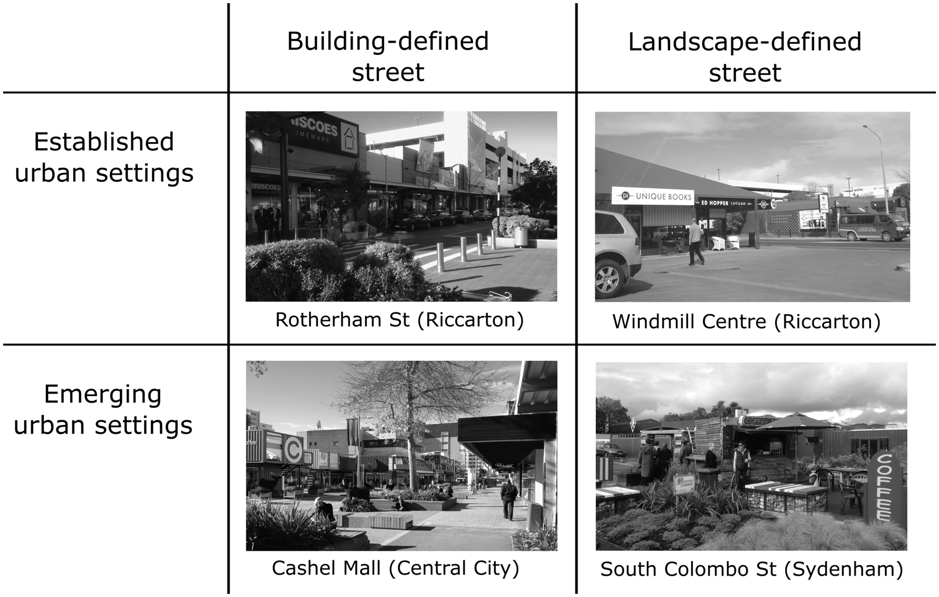
Case study sites
Rotherham Street is a building-defined street in an established urban setting. A north–south oriented retail street, it is surrounded by the Westfield Riccarton Shopping Mall. Large numbers of people use the street to access the mall as well as nearby stores, restaurant, cafés, and a pub. This pedestrian friendly street includes greenery and urban furniture, and during our fieldwork, people lingered in the site waiting for friends, for their lunch breaks, or after school and work hours.
The Re:START area in Cashel Mall is a building-defined street in an emerging urban setting made of colourful movable shipping containers along a pre-existing mall. Every fieldwork day noted some change, such as rearranged containers (FJ, 1 22 June 2012), new market areas (FJ, 17 August 2012), establishments that were open or closed as well as short term containers installations, and infrastructure being added or removed (FJ, 24 May and 14 November 2012). Continual space reorganisation affected peoples’ experiences of this urban setting.
Windmill Centre and South Colombo Street are both landscape-defined streets Windmill Centre is a more established and commercial centre hosting a café with an open area facing a carpark. The area faces north and is protected from easterly winds, generating a warm microclimate that proved to be a main feature on many days. South Colombo Street was an emerging, temporary site hosting a café located in a kiosk facing west and adjacent to the street. A gazebo located in the back of the kiosk is mostly used at lunch time and for business meetings. Although this site is not focused on tourism, its quirky style attracts people who ‘take photos and ask about the nature, start, and ideas involved on the concept’ (FJ, 8 February 2013). While temporary, this site has similarities to the Windmill Centre as a relaxed quiet area.
Each of the four sites had an open area adjacent to a café which served three purposes for this research: weather station placement, power source for data logger computer, and a place where potential interviewees gather.
Methods
The study used multi-sited ethnography (Falzon, 2009; Marcus, 1995) involving participant observation and interviews, and microclimate measurements to investigate cultural meanings associated with climate and weather in multiple microclimatic conditions. Participant observation provided information about general activity in the case study sites, later related to National Institute of Water and Atmospheric Research climate data (NIWA, 2013a) and our own microclimate data. Every fieldwork day started with one hour of participant observation, and the field note-taking process varied with the site’s urban form. In building-defined streets notes focused on street activity, including open areas at cafés, observed by walking along streets and stopping at strategic points. In landscape-defined streets cafés were used as a base for observation. In these cases, researchers interacted with customers, waiters, waitresses, and managers. Field notes were also taken between interviews and included information about numbers of people, the predominance of age and gender according to times of day and year, busier times, main activities, and post-earthquake character. A summary page was prepared each day (Lofland et al., 2006). Photos were taken throughout the fieldwork and general climatic data noted through the MetService iPhone application.
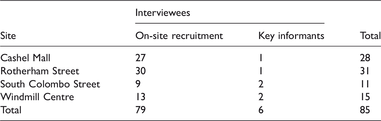
Semi-structured in-depth interviews allowed in situ exploration of complex relationships between people, climate and weather (Housley and Smith, 2011). Participants were recruited face-to-face (n=79), individually or in small groups, as a non-random cross-section of users from the case study sites. All interviewees were over 16 years old and were Christchurch residents for at least three years for two purposes: familiarity with local seasonality and personal association with the place (for the general public interview guide see Appendix 1). A small group of key informants was drawn from café managers (n=6) to contextualise the observations. They were contacted prior to the interview which covered the sites’ post-earthquake character, customer adaptation to climate and weather, and changes in use patterns (for the key informants interview guide see Appendix 2).
Understanding places’ spatial dynamics also requires methods that combine spatial and personal experience (Jorgensen and Stedman, 2011), therefore, interviewees undertook a mapping exercise aimed at exploring their preferred places and routes around the case study sites, and how these preferences connected to weather experiences and place qualities. Interviewees were asked to draw their favourite routes – especially walking routes – and favourite and least favourite places. These maps supported the analysis of preferred types of urban environments described by interviewees.
Interviewees in each case study site.
Microclimate conditions in specific urban places vary from the generalised local weather records that are typically based upon a fixed weather station. For this reason, on-site microclimatic measurements were collected to investigate the experiences described by interviewees, which were then compared to climate measurements from the official sources. A portable weather station (La Crosse, model WS2355) was placed on a tripod 1.20 m from the ground, which corresponded to the height of an average person when seated. Connecting the weather station to a computer (HP, model Mini 110-3500) allowed direct transfer of information through the software Heavy Weather 2.0. Data recorded comprised relative pressure, indoor temperature, outdoor temperature, outdoor humidity, dewpoint, windchill, wind speed, wind direction, and rainfall. Data were collected every minute, and the weather station was placed close to people using the open areas at cafés.
This case-based data were then compared to NIWA’s Kyle Street Weather Station data which records Christchurch city climate. 2 Microclimate data – maximum and minimum outdoor temperatures, wind speed and direction, and sunlight hours – were hourly downloaded from the CliFlo website (NIWA, 2013b) and referenced to times and days of fieldwork. The minute-by-minute data collected in the cases study sites were summarised, compared with data from NIWA, and related to the recorded dynamics captured through participant observation at the case study sites. This approach enabled an investigation into the relationships between climate, weather, and place dynamics.
Summary of findings
In this section, we provide an overview of the main findings, and then tease out specific aspects of the relationship between socio-cultural values, microclimate, and urban comfort. The interviews revealed that specific aspects of Christchurch’s urban culture influencing local urban comfort are related to both its biophysical landscape (geographical location, outdoor values, recreational and gardening activities) and its social landscape (Garden City as a way of living, urban lifestyle, and liveability). Discussions regarding the biophysical landscape highlighted that peaceful environments found in the outdoors (beach, forest, mountains) are also expected within the city. Therefore, there is a desire for contact with nature, greenery, and peaceful spaces for daily activities such as work, social life, physical activities, and family time. These socio-cultural values related to nature and landscape are intrinsic to the local culture and influence urbanity as locals prefer lower density (Bell and Matthewman, 2004). In this case, expectations towards the daily urban lifestyle and the environment where it takes place carries the socio-cultural aspects of the outdoor experience.
Consideration of social values of urban open spaces reinforced the emphasis upon lower levels of urbanity, characterised by peacefulness, personal space, and ‘relaxed’ types of social interaction. The combination of desirable biophysical and social settings provided the basis for local urban liveability ideals, characterised by a Garden City way of living based upon the idea that human society and nature are meant to be enjoyed together (Clark, 2003; Howard and Osborn, 1965). Based upon these broad findings, the next sections consider more detailed relationships between the spaces’ characteristics and dynamics, and their microclimate.
Dynamics of spaces and microclimate
Case study sites’ dynamics.
Microclimate data measured on-site and by NIWA.
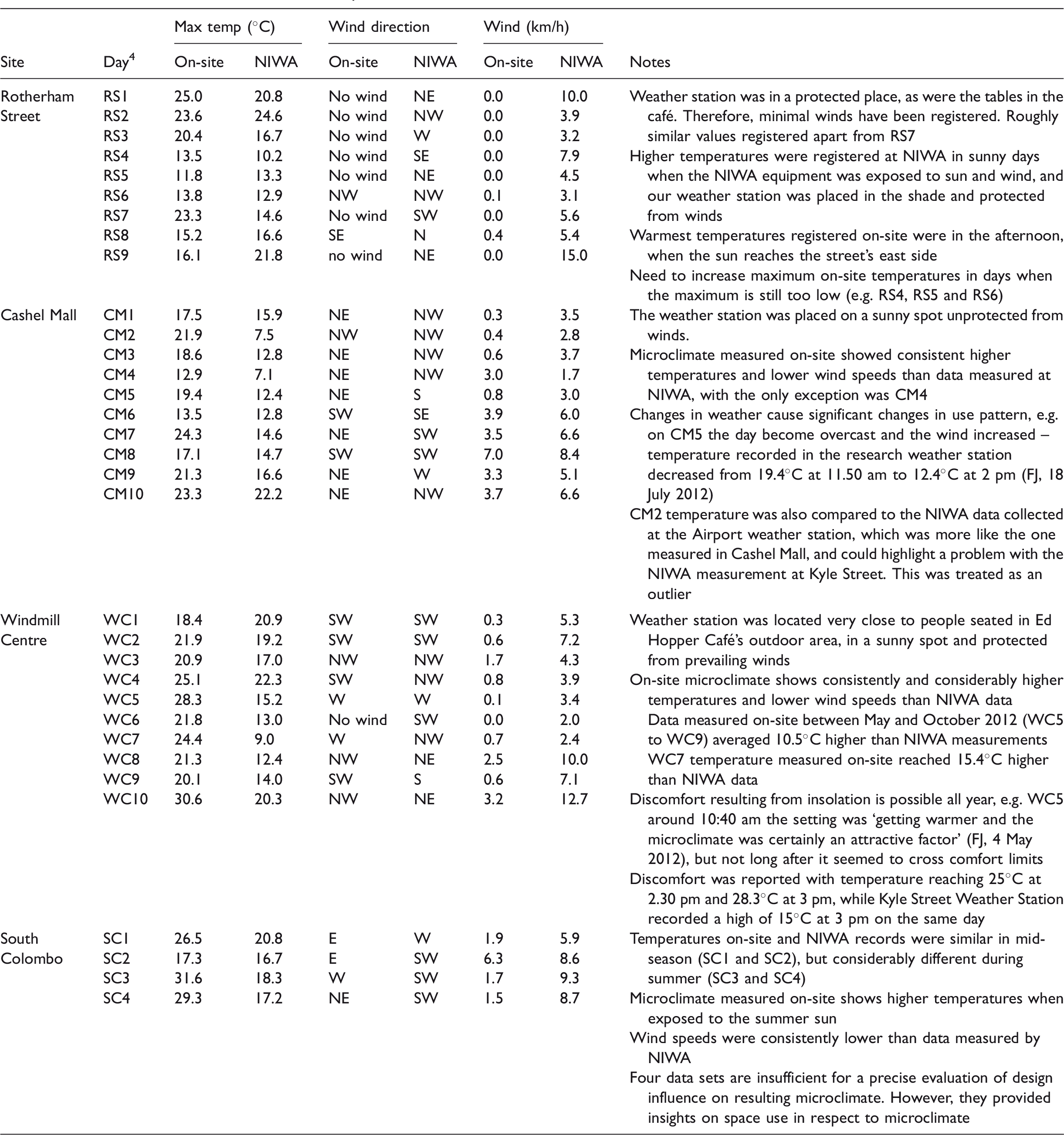
Figure 2 highlights each site’s location in the wider surrounding area, and their Christchurch context, based upon the maps drawn by interviewees. Rotherham Street and Windmill Centre were summarised in one map as they are in the same area. Despite being further apart, Cashel Mall and South Colombo Street were also analysed together, as the strong connection provided by Colombo Street made Central City features be frequently mentioned. The maps show streets and areas identified as ‘good’ (where interviewees like to walk and spend time, frequently associated with street trees and greenery, and fewer cars and noise), streets and areas identified as ‘bad’ (crowded and unsafe, both because of cars and other users), pre-earthquake favourite places (Poplar Lane, Sol Square, and Oxford Terrace), the case study sites, windy areas, sunny areas, and ‘nice’ areas due to the presence of nature.
Summary maps: Central City and South Colombo Street (a) and Riccarton area (b).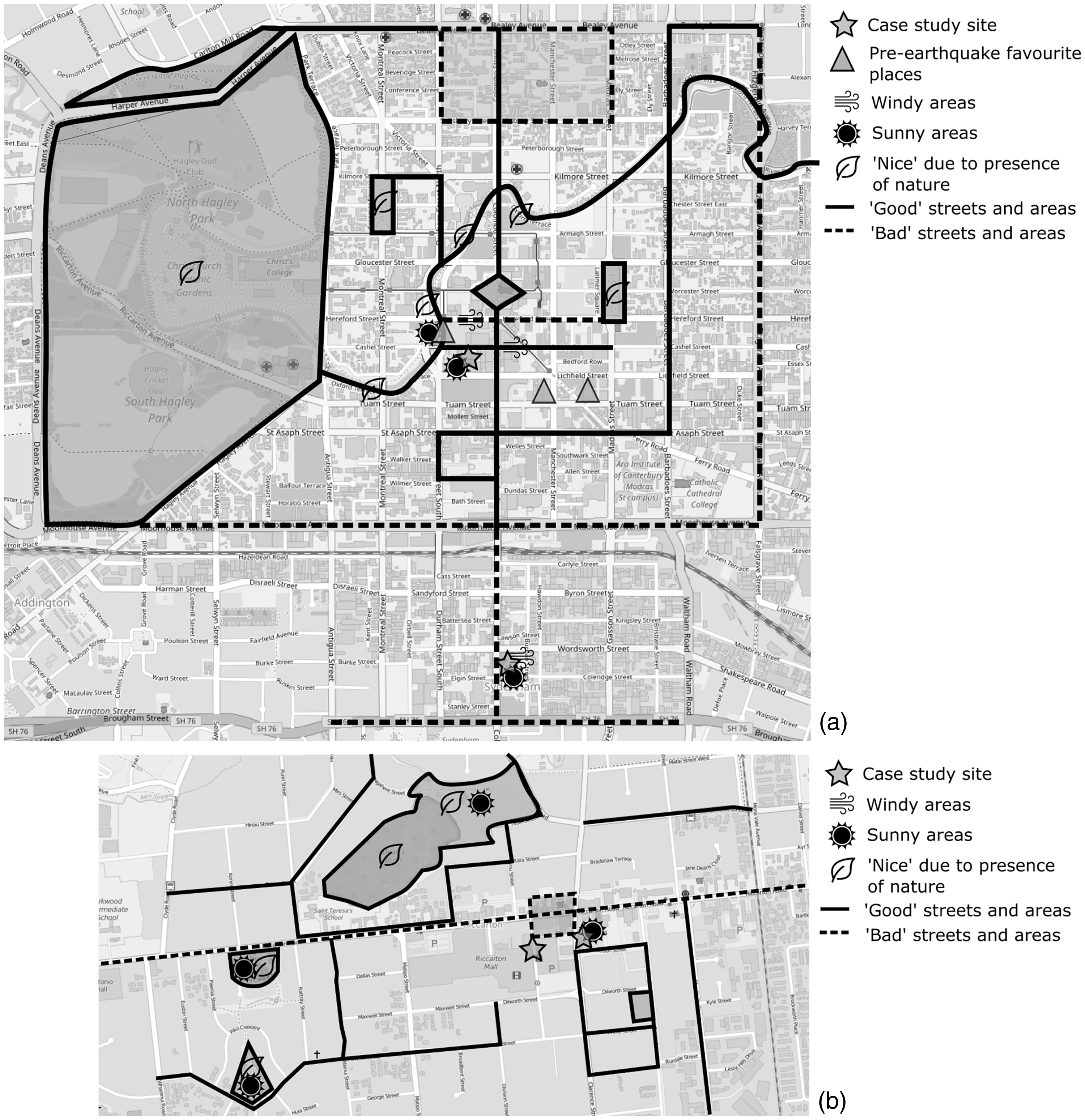
In the Central City map, Cashel Mall’s Re:START courtyards were mentioned as favoured places as they are sunny and protected from winds. The ‘transitional’ character was regarded by interviewees as an important feature influencing choices for places, and ‘as a Christchurch person, you are becoming used to the sort of what you call gap filler’ (E79). People liked transitional sites because of the ‘innovation that is going on around Christchurch and how it is always changing’ (E69), and so described them as ‘attractive and inviting’ (E30). It was also described as ‘a good way of bringing people back into activity doing something unexpected and colourful which attracts tourists’ (E80). Other areas of Cashel Street and Hereford Street were described as shaded and windy, these areas were considered good places for shopping, but not for being outdoors. Oxford Terrace was a favoured place prior to the earthquake because of its orientation facing west and protected from cold easterly winds. Areas along the Avon River and the three main squares in the CBD – Cathedral Square, Latimer Square and Cranmer Square – were referred to as nice places because of their natural aesthetics, more than their microclimate. Places like Poplar Lane and Sol Square were mentioned as good social places. In the same map, South Colombo Street was described as a sunny and unsheltered space, good to be in still days, but unpleasant on windy days. This site was described as ‘a place you might be passing by and think of stopping [but not] go out of their way to specifically [go t]here’ (E79). Colombo Street itself was mentioned as a ‘normal’ but pleasant street within the four avenues, but an unattractive street when it reaches Sydenham. These reasons for ‘being there’, and being part of the temporary Christchurch, made people handle the weather and microclimate in a special way.
Riccarton map shows Windmill Centre as a sunny and sheltered area, preferred by interviewees as a place to go and sit outside despite the unappealing grey landscape. Rotherham Street in not sunny or windy, and its main appeal is the social environment and shopping opportunities. Riccarton Road was described as noisy and uninteresting, but all other streets around were described as fine, with some offering better environments than others. Deans Bush, Shand Crescent Reserve, and Harrington Park were highlighted as sunny places to be close to nature, and no specific windy areas were highlighted around the case study sites.
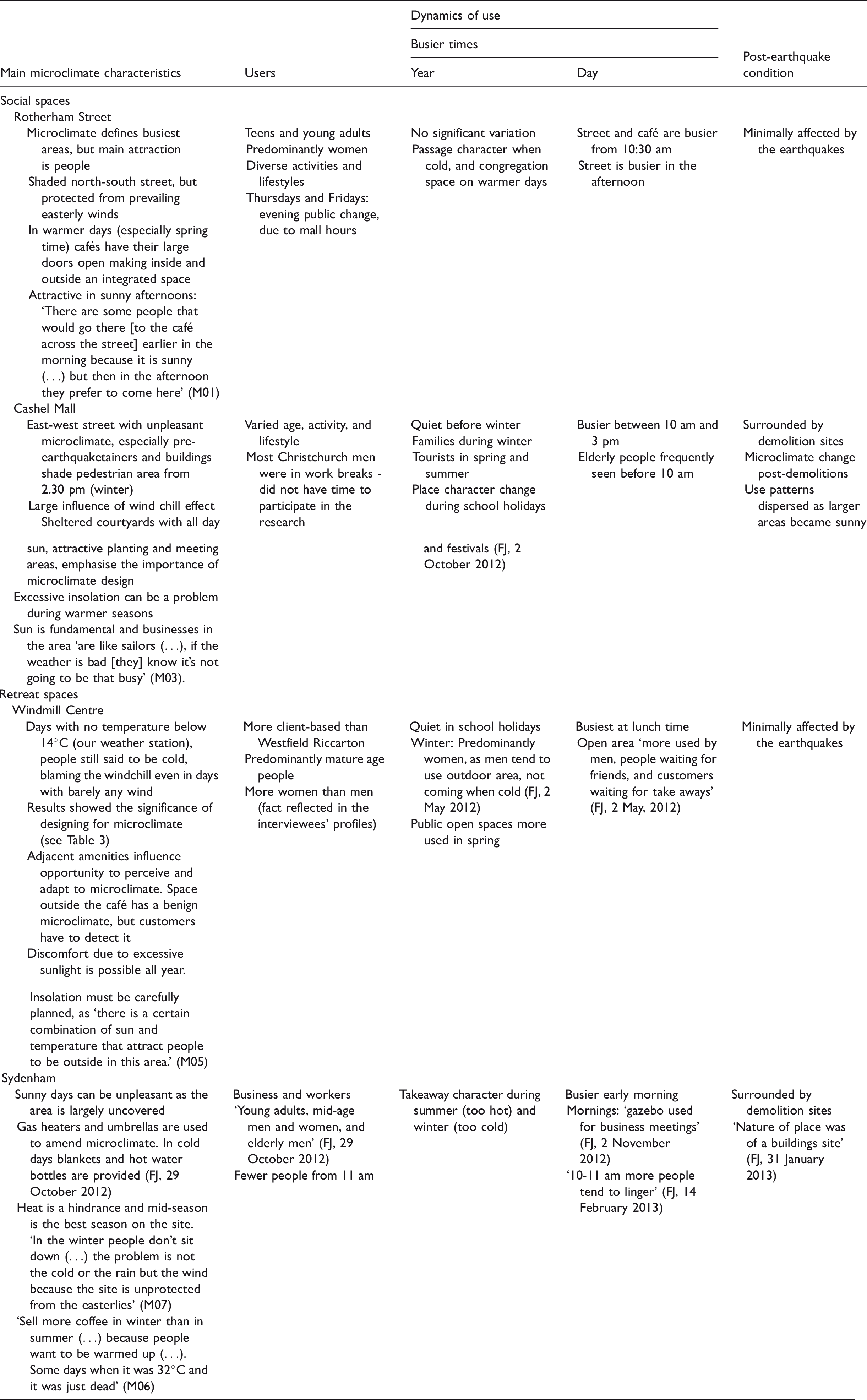
The maps above support the information summarised in Tables 2 and 3. Based on on-site observations, Table 2 relates the microclimate characteristics of each site with the users they attract, the variation of space dynamics over the years and the day (highlighting the relationship of place dynamics and weather variation), and the impact of post-earthquake condition on users’ experience. Table 3 summarises data measured on-site and by NIWA, users’ response to those specific microclimatic characteristics while NIWA recorded different weather conditions (see notes on Windmill Centre data), and the change in use patterns due to quick changes in comfort conditions (see notes on Cashel Mall).
Discussion
This study commenced with a focus upon enhanced understanding of social adaptation to urban microclimate. The Christchurch earthquakes and constant aftershocks during the fieldwork introduced many new challenges, but also opened up new potentials, and the methodology presented here evolved as a way to turn challenges into opportunities for investigating locals’ adaptation to microclimate in changing urban conditions. When applied to urban design and planning, research methods must be especially sensitive to the more subtle social dimensions of urban living. Context-sensitive methods, such as the ones used in this research, help identify how urban characteristics contribute to people’s experience and well-being, connecting social outcomes to urban structure (Kyttä et al., 2016). As Eizenberg and Shilon (2015: 1123) pointed out ‘planning theory and practice are in need of more tools and mechanisms for gathering, making sense of, and applying this new information’. The integrative methodology presented here allowed for exploring experiential dimensions of climate, and weather which cannot be detached from the characteristics of urban environments (Franz and Wiener, 2008). The interpretive research strategy provided opportunities to explore people’s experience of climate and weather; what it means to be hot, cold or comfortable. In Christchurch, the Garden City identity plays a role in shaping seasonal meanings, as ‘when the first daffodils show up, when you see the length of the days affecting the plants’ (E76). These meanings affect adaptation to local climates and weather, and in Christchurch this adaptation is dependent on both being in contact with nature, and on being social.
Regarding thermal preferences, our findings have shown that cooler temperatures are preferred, while spaces’ use and comfort are mainly dictated by exposure to sun and protection from winds. Comfortable conditions are easy to achieve in many days during the year as, apart from daylight hours, some days are similar in winter and summer regarding perceived temperatures and humidity. In some winter days – in an adequate microclimate – the temperature reached 24.4℃ (see WC7 on Table 3) and there were summer days when 12℃ was registered during a day with a maximum of only 23.3℃ (see CM10 on Table 3). The local self-image of ‘tough people’ who ‘don’t let things get on [their] road’ (E26) has a role on adapting to climate (Cupples et al., 2007), for example, when Christchurch presents conditions elsewhere known as uncomfortable, but described as ‘good’ by interviewees. Such insights would not have emerged using conventional approaches from building sciences.
However, the interpretive methodology also encountered challenges regarding the post-earthquake environment, participants’ recruitment, weather station placement, and integration of research methods. During the pilot study, only a few sites were accessible around the central city, and the intense urban repairs made it difficult to get permission to work in some sites. Some established settings considered as case study sites had to be closed, and some became unavailable overnight. Emerging transitional settings were taking shape around the city and there was no guarantee how long they would remain in place. Furthermore, the emerging sites became tourist attractions in the warmer seasons, making it difficult to interview locals. These dynamics emphasise the need for an adaptive methodology whose validity was not compromised by concerns such as representative sampling. Figure 3 depicts the changing nature of these emerging settings over the course of fieldwork.
Changes in emerging sites: Cashel Mall (top) and South Colombo Street (bottom).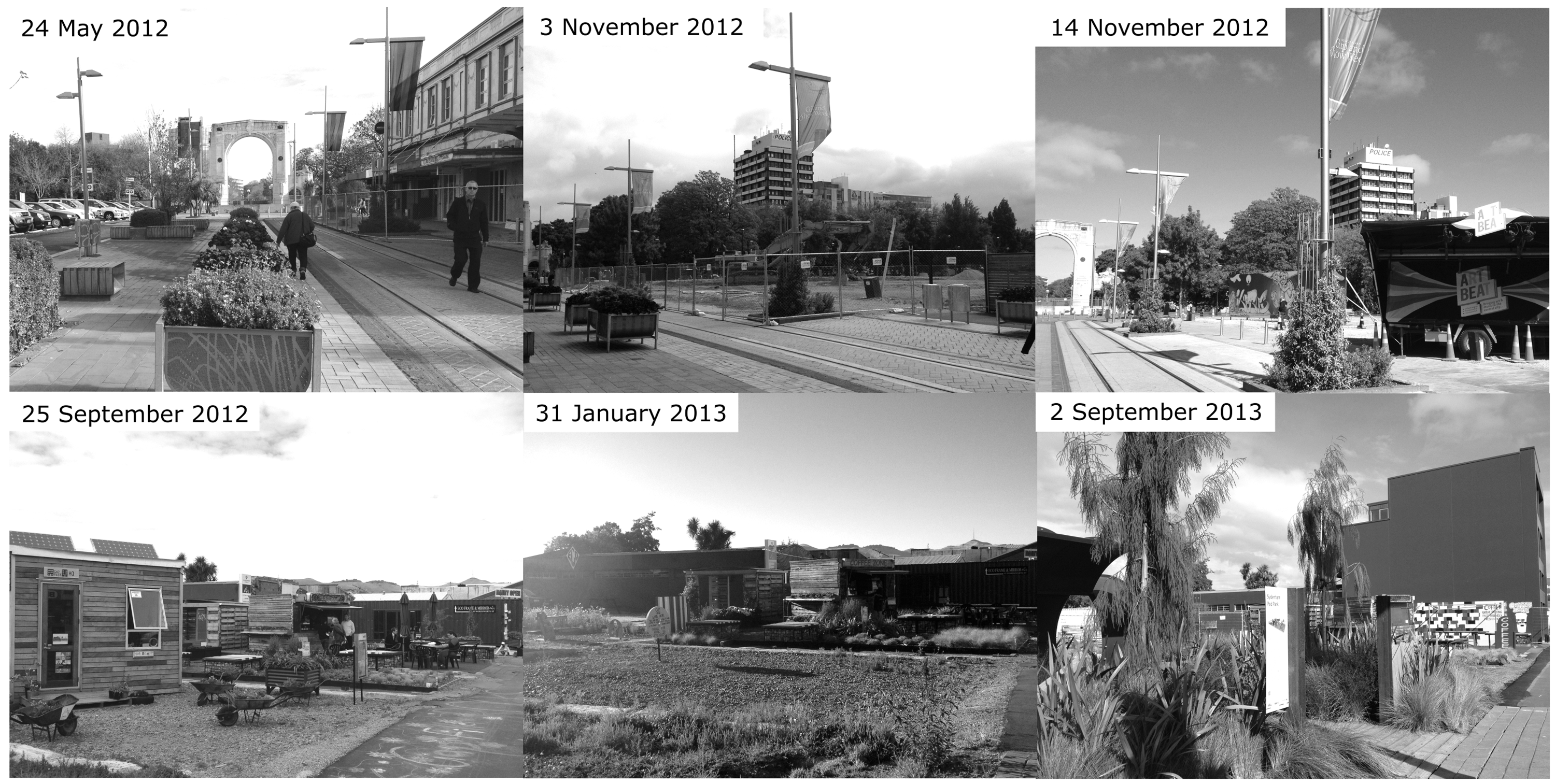
The nature of the case study sites presented recruitment challenges as the time spent in the field was dependent on site’s activity, and cafés’ opening hours limited the fieldwork time. People who were unavailable at the times when the fieldwork was carried out or who live and/or work in different areas from the case study sites, were not interviewed. Moreover, the number of potential interviewees on the sites varied according to the site’s urban form. This did not necessarily compromise the data because activity in some sites happened in a restricted area, and therefore, was easier to be explored. Large numbers of people on the sites was also challenging as the face-to-face nature of the recruitment strategy and confidentiality requirements demanded careful judgement on how to approach and interview people in the cafés. These settings needed potential interviewees but not so many that would compromise privacy. All these factors made interviewee recruitment difficult at certain times of the day.
Challenges regarding the weather station were related to the communication between weather station and data logger, which was at times temperamental because of intervening building materials. In an emerging urban setting the containers’ steel influenced the wireless connection between the devices. When the weather station and the data logger computer were changed to a different location, the new host soon become unavailable for this research and a third option had to be chosen. Another issue was security in building-defined streets, as in these sites we have not concentrated in one single space and the weather station was sometimes placed far away from where interviews were conducted. Moreover, during school holidays children were on the sites and tended to be curious about the equipment.
The microclimate measures allow the interpretation of what interviewees mean by pleasant, windy, hot, cold, and so forth, and data were analysed and broadly categorised according to its similarities and differences from data measured by NIWA. This approach also showed the influence of design decisions on resulting microclimates, as design solutions significantly modify microclimate in Christchurch.
Conclusions
Urban design and planning still tend to make use of generic solutions instead of locally-based ones (Eizenberg and Shilon, 2015). Despite calls for evidence-based solutions, the outcomes of implemented projects are rarely assessed post-implementation. As a result, professionals cannot know if adopted solutions were successful (Brown and Corry, 2011; Laurian et al., 2010). The methodology developed for this study focused on existing spaces, therefore, contributing to a post-implementation understanding of place uses in relation to their microclimate. This methodology provided three main contributions. The first one involves the use of an interpretive strategy and the addition of a new dimension to the approach and understanding of human comfort in urban environments. As highlighted by Nikolopoulou and Steemers (2003) adaptation is dependent on physical, physiological, and psychological factors, but as pointed out by Knez and Thorsson (2008) it also depends on socio-cultural factors. The adoption of an interpretive methodology allowed the investigation of how cultural factors and meanings related to climate and weather can be understood, helping to make sense of why public spaces are used in particular ways.
Interpretive research on urban design has typically adopted descriptive methodologies based upon observations (Gehl and Svarre, 2013; Whyte, 2001). Gehl and Svarre (2013) claim that direct observation help understanding why spaces are used or not. While our work has supported observation as fundamental to investigate spaces’ dynamics – helping to understand how spaces are used and what areas are popular – it also reveals that observations are insufficient to comprehend the uniqueness of culture and place, and why people choose certain places, levels of urbanity, and their adaptive capacity thresholds. An interpretive approach based upon in-depth interviews provided the necessary insights into people’s motivations to adapt.
An interpretive strategy alone, however, would not provide insights regarding the relationship between people’s experiences and the biophysical dimensions of urban comfort. A link between participants’ description of climate and weather, and the microclimate at the time of interviews was needed. In response to this, the second methodological contribution is an integrative methodology combining interpretive strategy and microclimate measurements, which allowed for comparison of respondents’ experience with the measured microclimate conditions.
The third methodological contribution highlights the importance of flexible research strategies in highly dynamic urban environments, in this case in a post-disaster context. This situation added an extra layer of complexity, meaning the study was less controlled, but it allowed urban comfort to be tested from a broader perspective and influenced by several unexpected variables. In addition, the interpretive strategy allowed the investigation of how rapidly changing environments influence adaptive capacity. Fieldwork in face of instability requires a robust and flexible approach, the adopted methodology effectively adapted to this dynamic context and provided a coherent body of evidence regarding the nature of urban comfort. Future research might extend the methodology to other regional settings, to test whether the claims we have made about the socio-cultural dynamics of microclimate adaptation also occur in other types of setting, other climates, and other cultures.
Contemporary urban societies are complex, requiring flexible urban design approaches (Duarte and Beirão, 2011). The methodology developed to investigate the socio-cultural concept of urban comfort in a post-earthquake setting may be valuable to better understand people’s experience of – and adaptation to – dynamic urban landscapes changing for other reasons. Therefore, there is also opportunity for future research to apply the presented methodology to a range of transitional urban situations such as research on the impacts of climate change, or socio-economic and natural pressures to change.
Footnotes
Acknowledgements
The authors would like to thank the managers of the cafés in the case study sites who allowed the placement of the weather station for data collection, and the 85 anonymous respondents of this research.
Declaration of conflicting interests
The author(s) declared no potential conflicts of interest with respect to the research, authorship, and/or publication of this article.
Funding
The author(s) disclosed receipt of the following financial support for the research, authorship, and/or publication of this article: This research was funded by a PhD fellowship grant from Lincoln University, New Zealand.