
Abstract
Agra was the capital of the Mughal Empire at its zenith, and the splendour of the city during this period can only be imagined. There is an abundance of royal buildings which are protected by the Government of India. There were other significant buildings too, housing the high nobility, away from both the royal quarters as well as the ordinary peoples’ houses. These have largely vanished, being large enough to attract builders as well as developers. The article describes and establishes the significance of one such rare traditional townhouse or mansion called ‘haveli’ located on the river Yamuna, Agra, in relation to a larger historical and cultural landscape. It also discusses the possibilities of conservation and management for protecting and enhancing the significance of the premises and planning for its sustainable development in future.
The current edifice appears to be a coalescence of British and Mughal architecture with some local features. The building stands where similar-sized havelis stood during the Mughal period, housing high nobility. The architects of these buildings efficiently used the features of the river. With most such havelis having disappeared from the riverfront, this large residence-like edifice provides an interesting glimpse of the lost heritage. Fragments of information obtained from old maps and paintings, site surveys and some few research works have been joined together to reconstruct the origin and transformation vis-a-vis the present condition.
Keywords
Context
Few people realize the importance Agra riverfront enjoyed during the Mughal reign in India. It was a vibrant place, unlike today, imaginably no less busy than the city centre. It was used as a long-distance waterway but also as a corridor by locals living or working next to the river. It was also the venue for social activities, largely participated by the royals and the high nobility. The land from the tomb of Itimad-ud-Daulah and the Agra Fort and later up to the Taj Mahal was perhaps prime location. It was owned and occupied by high nobility with their manors/detached townhouses called havelis lining the length of the river on the right bank all the way up to the Red Fort and then beyond. The left bank was largely landscaped with gardens, to provide a great view from across the river to those occupying the royal quarters. The gardens were also for use by the high gentry and with no bridge across the river, boats were conceivably the only means to reach them.
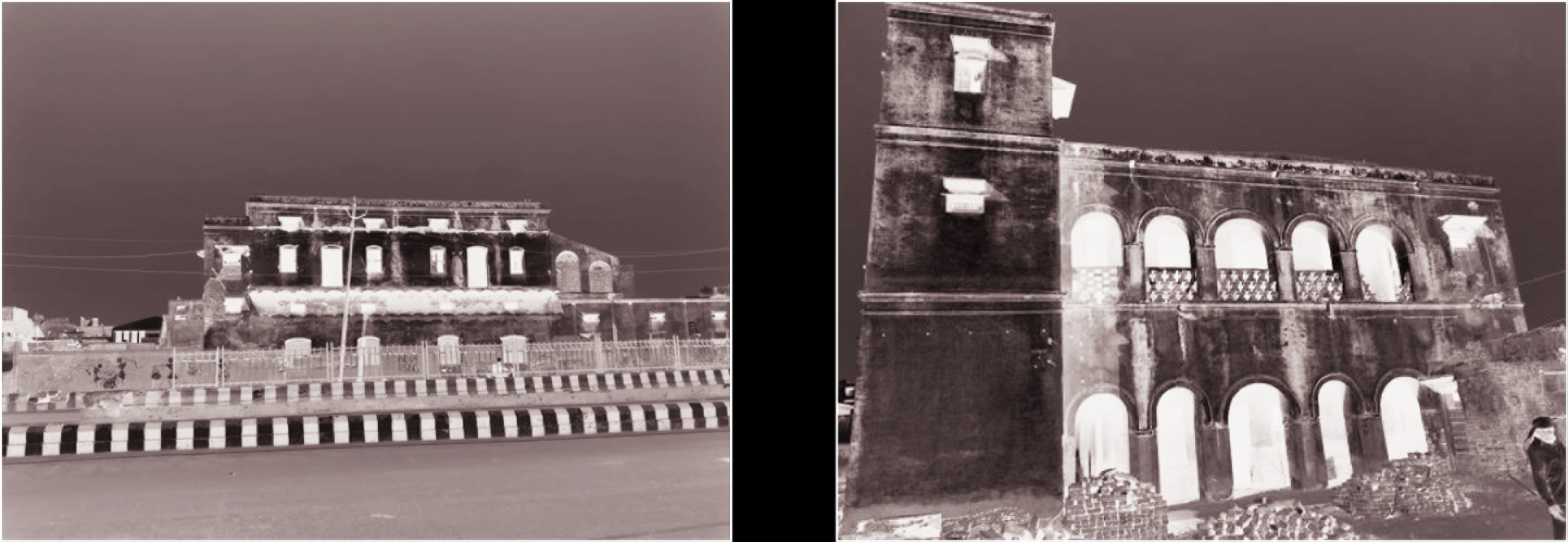
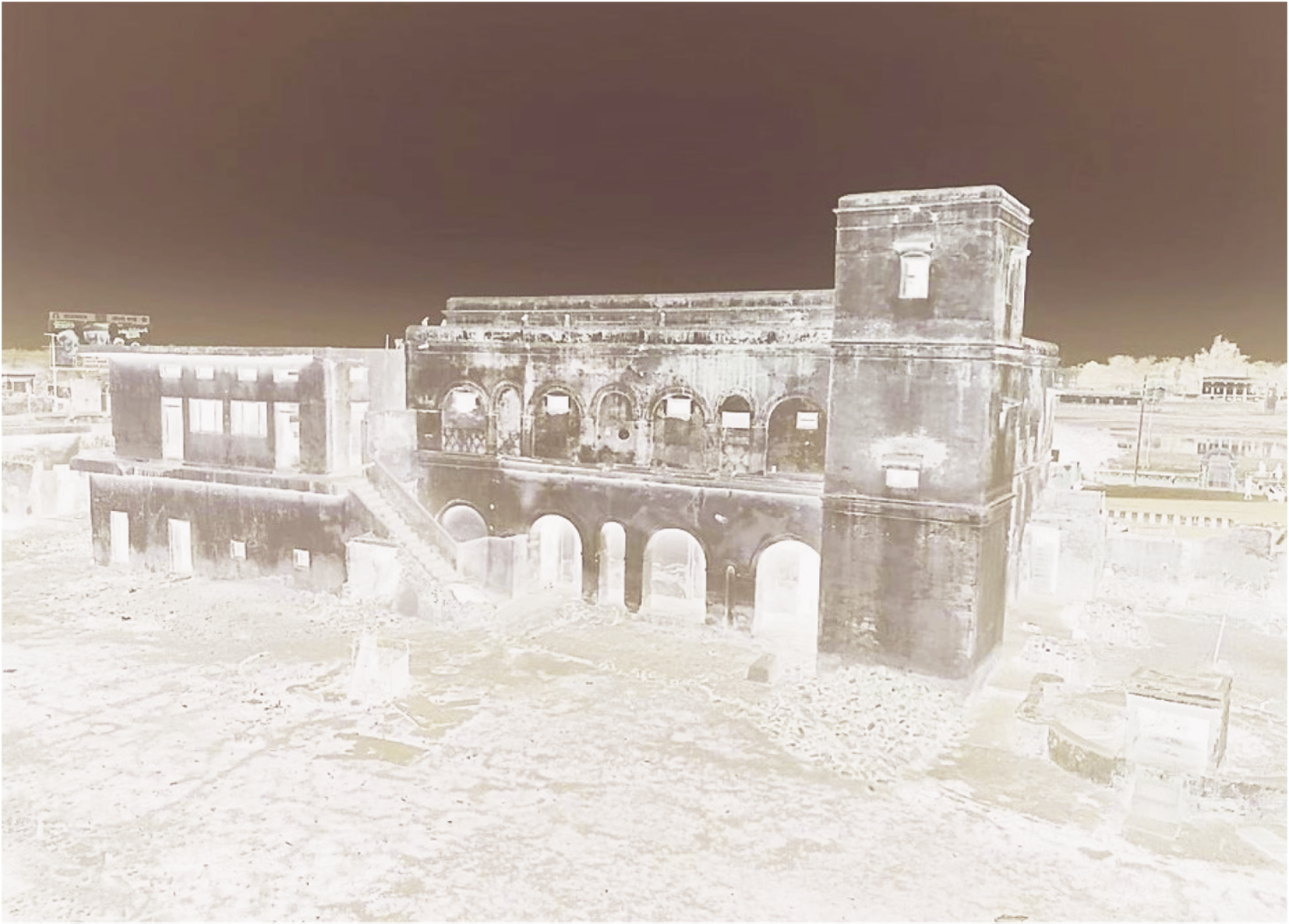
Recently, a large detached townhouse or mansion (haveli), located on the riparian Yamuna Kinara Road, opposite the Itimad-ud-Daulah has been drawing visitors as it seems to be standing at the site or has parts of an old Agra riverfront haveli, which in all likelihood, at one point belonged to Shaista Khan (Koch, 2011), Emperor Shah Jahan’s influential brother-in-law (Figures 1a and 1b). The piece of land perhaps changed hands a few times since but was surely owned by a senior noble during the Mughal Empire. This is evident by its proximity to the royal quarters. While on site, a stretch of imagination can easily give a visitor a good feel of how life on Agra riverfront could have been during the Mughal Empire.
Historical Background
River Yamuna is the lifeline of Agra and historically the main source of freshwater for the city. It is particularly generous in its course at Agra and takes several turns within a short distance thereby giving a longer riverfront and an opportunity to the architects to exploit it. The convolutions increase the field of vision between the various sites and buildings located along the river thereby reducing the visual distance between them. The Mughal architects were quite apt at using the riverfront features in enhancing the architecture of the buildings. This is evident by the presence of several riparian monuments and gardens. The first riverfront gardens at Agra were laid by Babur which became the model for future designs of successive royal complexes including the Agra Fort, the Taj Mahal and Itimad-ud-Daulah as well as the garden residences of the nobility. Sikandara is a bit further away from the riverfront than the rest of the monuments. Most of these monuments were built during the reign of Akbar–Shahjahan (1556–1650
After Shahjahan shifted his capital to Delhi, the mansions were gradually abandoned by the nobles and the grandeur of the magnificent cultural landscape started to decline. The city was repeatedly attacked by local and foreign clans until it came under the East India Company in early 1800s. The final blow to this arrangement came after the Indian Revolt of 1857. Many buildings around the fort including the mansions were razed to ground during the battle or for other related purposes (Losty & Koch, 2017). In the coming decades, roads and railways were built cutting through these large vacant sites. Some mansions were transformed to cater to the growing needs of an industrialized town. The introduction of new materials and engineering systems that came in with the colonial link altered the state of the art in the field and changed the way buildings were constructed. Architecture and construction of personal dwellings also underwent a significant shift in this period.
The haveli, which forms the focus of this article is located on the Yamuna Kinara Road and seems to be one such haveli that has stood the test of time albeit with transformations. The building has prominent features of English classical architecture, but a closer look reveals Mughal and local architectural elements as well making it an interesting place to visit. The building’s mixed architecture spanning from the pre-British to the modern era urges a visitor to try and visualize how a Yamuna River Front haveli may have looked like during the Mughal period.
Methodology
Since most of the nobles’ mansions do not exist now and there is scarcity of recorded descriptions in literature, the study mainly relies on historic maps, paintings available in public domain, and a few research papers and correlates the findings with the site investigations. A detailed documentation and condition mapping were also carried out for the site and the components which formed the basis of the assessment and proposals. Site issues as well as local by-laws, regulations and international principles and guidelines for conservation of cultural heritage have also been considered for developing the proposals.
Findings
Literature Survey
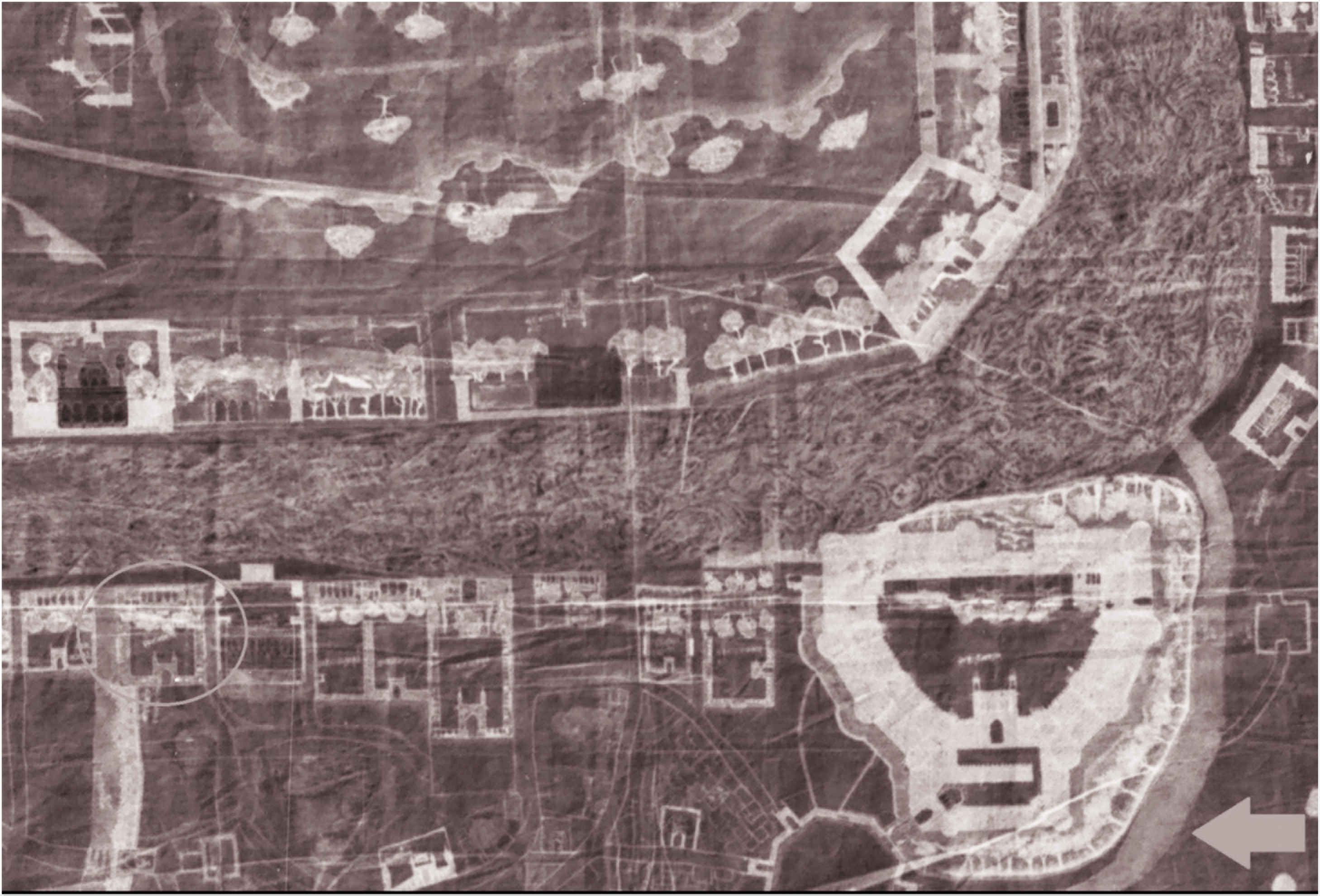
According to historic maps, Shaista Khan’s haveli was located a short distance north of the Agra Fort. It was located opposite Itimad-ud-Daulah, Tomb of Mirza Ghiyas Beg, the father of Empress Noor Jahan and grandfather of Empress Mumtaz Mahal. Due to the noble stature of Mirza Ghiyas Beg, the tomb is located on the river bank and close to the royal quarters, the Agra Fort. It was flanked by Zafar Khan’s haveli (a nephew of Empress Nur Jahan and brother of Empress Mumtaz Mahal) and the Mubarak Manzil Mosque (later converted into custom’s house by the British) on the north and south side respectively.
The architectural details of the original haveli are obviously lost but some information is available from historical sources. A scan through the earliest available maps and paintings of Agra city (Figures 2a and 2b) suggests that the original haveli, located at the same site as the current structure was enclosed within a rectangular, walled compound almost touching the river bank. It was accessible through a grand arched gateway located in the rear (western) boundary wall facing the city. The complex was almost symmetrically designed as the contemporary royal buildings, containing a riverfront building placed centrally on the eastern edge and a garden on the west. The riverside part was more private and most likely meant only for the nobility. The rear of the haveli was connected to the rest of the city through streets, which could be traversed by horses, carriages or on foot. Water for the garden and the building must have been sourced from the river through a system of Persian wheels and pulleys and distributed by the means of channels and tanks. Miscellaneous, small quarters housing servants’ quarters, utility rooms, and resting halls for travellers aligned the other three boundary walls. The main building probably too had a rectilinear design, with a projected pavilion composed of ornamental cusped arches facing the river, meant to create an airy viewing deck and to attract attention of those travelling by the river route. The undetailed and simple double-storied structure behind the pavilion illustrated in the scroll appears to be a nineteenth-century addition. According to the scroll image, prominent square staircase towers highlighted the corners of the haveli. A system of drains and canals had been developed by the nobles for conveying the wastewater into the river and for bringing river water into the city respectively (Ray, 2016). A communal drain is marked along the northern edge of the haveli in the eighteenth-century map of Agra and can be found even today at the same location.

Site Survey
Current Architecture and Character-defining Features
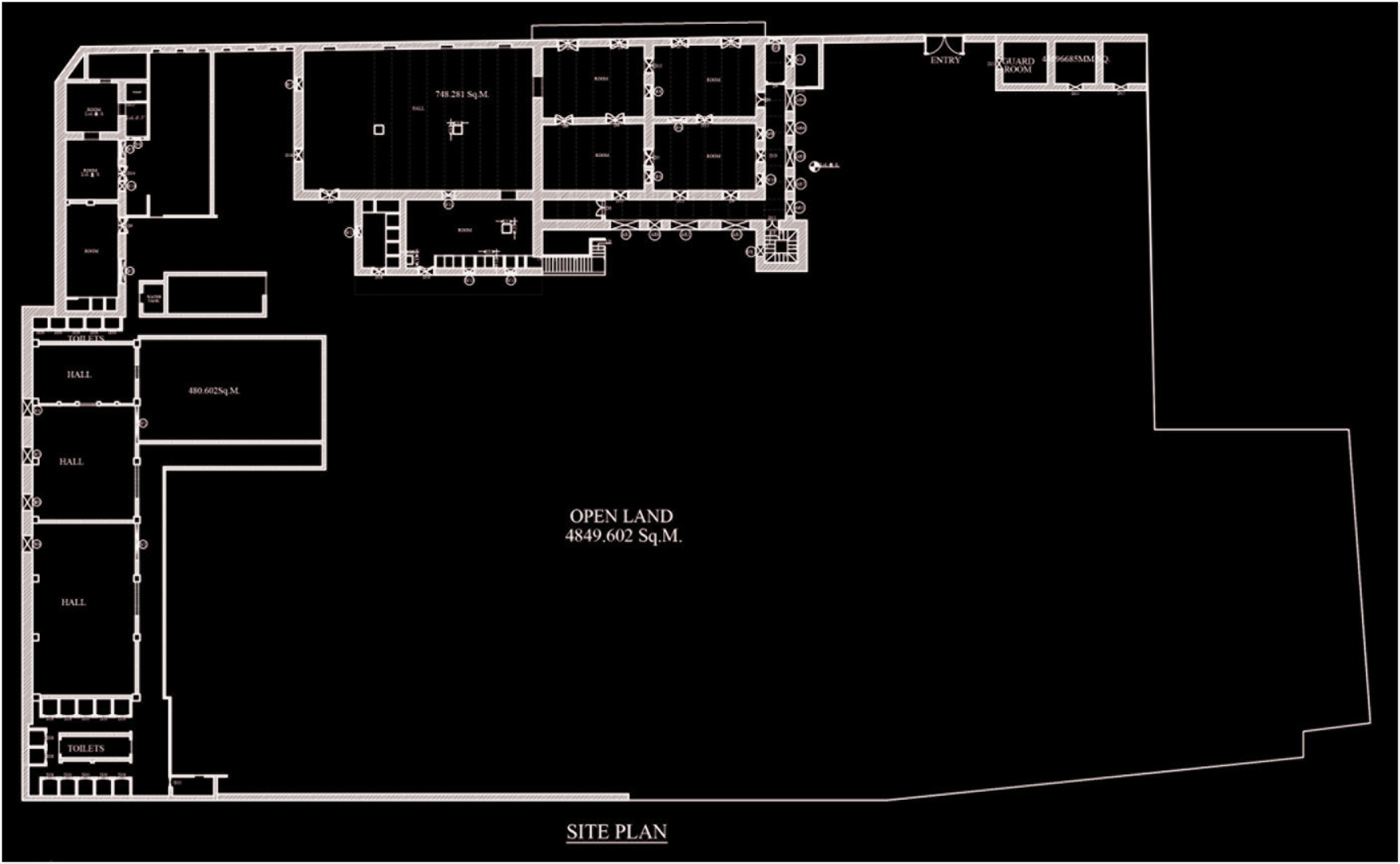
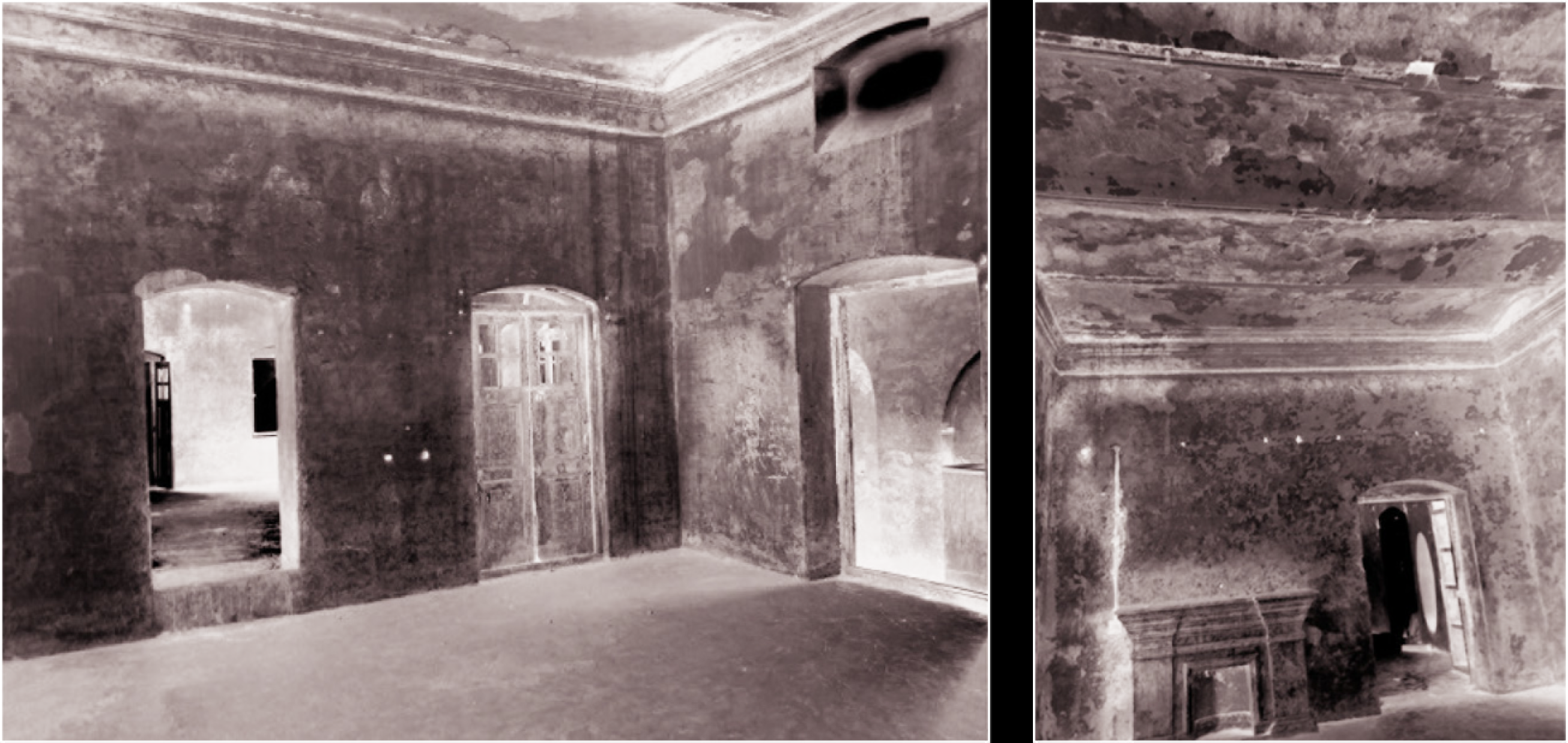
The current edifice seems to have retained some of the features described in the previous section while some new elements have been added as well. The building gives the impression of late nineteenth or early twentieth-century structure exhibiting features of primarily British architecture. It is modestly ornate but has a strong architectural character. It comprises a double-storied structure, laid on a nearly rectangular plan abutting the Yamuna Kinara Road. The longer eastern edge is slightly skewed and opens directly onto the road overlooking the river. Internally the riverside building is divided into two halves-one containing a large hall and the other subdivided further into smaller rooms (Figure 3). The southern and western sides are surrounded by covered arcaded verandahs (Figures 1b and 5). They were probably designed to protect the rooms from the harsh summer sun and also act as circulation spaces. There is a square tower containing a stairwell on the south-western corner of the building leading to the upper floor and terrace. The projected pavilion and the north tower and quarters along the boundary walls shown in the nineteenth-century scroll painting are missing in the design. The edifice displays conspicuous use of English architectural features such as long verandahs composed of semicircular shaped arches, and internal spaces spanned with jack arch roof slab technique. Segmental arches are ubiquitous in the door, window and ventilator openings (Figures 4a and 4b). Ventilators were an adaptation of British architecture in India to keep building interiors cool during the hot summers. Some other interesting features present sporadically are fireplaces and a large oval niche. Indigenous elements like sandstone sunshades (locally named as chajjas) supported on carved stone corbels/brackets, four-sided door frames and the use of the old Mughal bricks (called lakhori bricks) for construction provide an interesting hybrid character to the building. New additions and alterations are distinguishable by the use of the modern brick and rectangular openings (Figure 5). Simple yet well-defined mouldings outline the arches, parapets and ceilings.
Significance and Need for Conservation
The haveli is culturally significant due to its unique and strong historical link. It was part of an important cultural landscape of the Mughal period where the river Yamuna was the focal point. Factors governing its location, the proximity to the fort and the river, Zafar Khan’s haveli to the North and the Mubarak Manzil (partially preserved) on its South and the haveli’s association to Shaista Khan, all indicate its historical significance. Though its current architecture primarily belongs to the colonial era-a transitional stage between the Mughal period and post-independence, the haveli and its surroundings provide enormous scope to understand the various strata of evolution. The layers of history are evident from the different materials and construction techniques used in various parts of the building and its surroundings. Since most of the havelis on this stretch have been lost to dense urbanization, the site being currently uninhabited and encompassing a large open land (that possibly could have been a garden) can be a missing link in the interpretation of the lost riverfront heritage. However, if not conserved or protected soon, the haveli, like the other riverfront mansions, may succumb to developmental pressures or its own poor physical state.
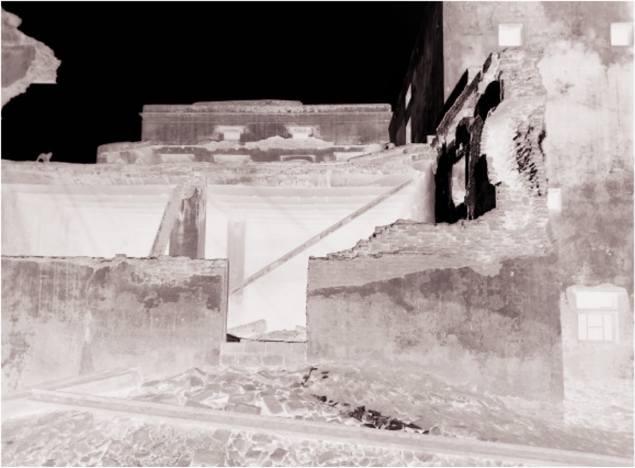
Condition Assessment, Current Issues and Threats
A detailed condition assessment of the building and its surroundings was carried out. The building is in a dilapidated state and certain sections of the roof and wall have collapsed due to a long period of negligence. With no current protection and management on site, the debris of the collapsed portions is still lying on the site (Figure 6). Structural failure including cracks are visible in certain parts of the walls, arches and roof and need immediate attention to prevent further damage. Since most of the wall surfaces are currently plastered and painted, the actual state of masonry can be known only through further investigations. The building is unoccupied and lacks basic building services such as plumbing, electrical supply and fire safety. Several inappropriate additions and alterations executed over the time are undermining the internal architectural character. The building and the site are riddled with many other issues such as poor drainage and waterproofing, leading to rampant seepage through the roofs and the ground (especially from the adjoining drain), rotting of wooden doors and windows. Absence of a buffer zone or setback makes the site vulnerable to air and noise pollution from the heavy vehicular traffic on the Yamuna Kinara Road. Currently, there is no landscaping or flora on the unbuilt land as it was being used for industrial activities for over a century. The site is also plagued with the presence and destructive activities of monkeys as in the other parts of the old city. Risk of flooding from the River Yamuna may also be a possibility in the future.
Development of the Site and Current Management
The spatial and architectural characteristics of the existing building indicate that the building was initially designed for residential purposes but later converted to industrial use. According to late nineteenth and early twentieth century maps, the premises first functioned as a railway delivery agency and later housed a carpet manufacturing factory (Baedeker, 1914). This occupation continued till the 1970s when it was severely damaged during the floods in Agra and discontinued thereafter. It was purchased by the current owners in the 1980s. The nineteenth-century Agra scroll depicts that the building had been architecturally transformed in early nineteenth century itself. During the Mughal period, the river almost touched the entire stretch of the havelis and could be accessed directly. However, the Yamuna Kinara Road constructed by the East India Company during 1837–1838 sabotaged the spontaneous connection of these residences with the river.
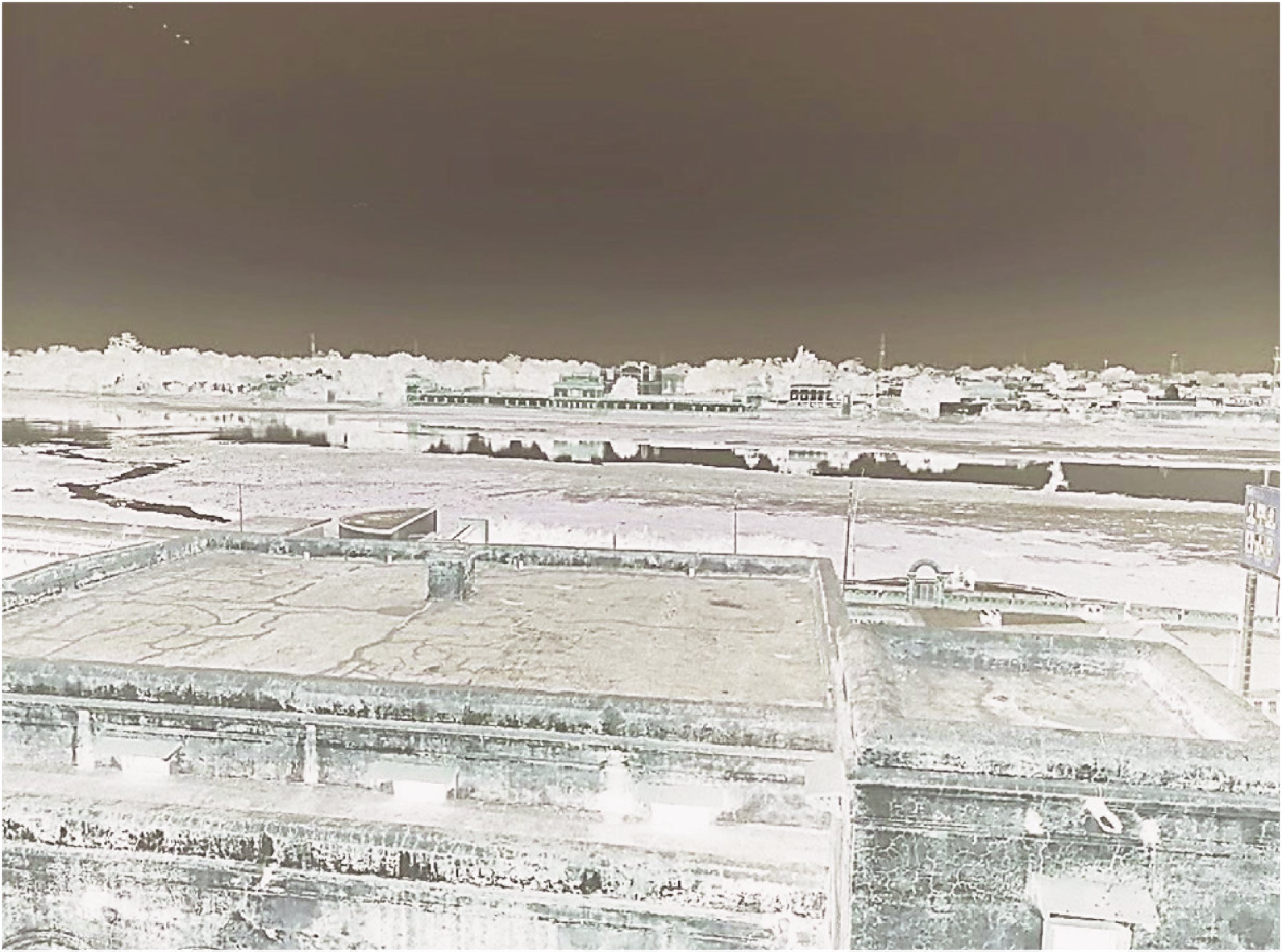
After India’s independence in 1947, except the Fort and the Taj Mahal and few other monuments, the right bank lost most of the other buildings and gardens to unplanned, rapid urbanization, fueled by population growth, aided by the ignorance of the people and the apathy of the authorities, who were too busy with the bulk of other work to think about conserving the heritage structures and the riverfront landscape (Figure 7).
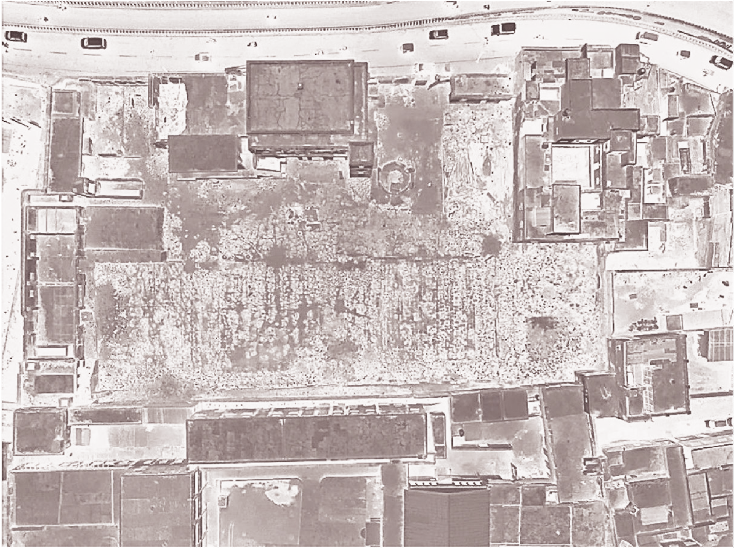
Today, as one drives along the Yamuna Kinara Road, the original character of Agra riverfront seems obliterated. Some of the gardens and tombs (such as Chini ka Rauza, Mehtab Bagh and Itimad-ud-Daulah) on the left bank have been protected and revived by the ASI (Figure 8). However, there has been little effort so far to protect any of the remaining historic buildings on the right bank which are being constantly lost to urban pressures. A few neglected and dilapidated structures with such elements can be found along the river today, often partially sunk in the ground. Some of these structures and ruins were identified and documented during the preparation of the heritage listing for INTACH, New Delhi in 2004 by the author and her team. A reconnaissance survey of the right bank reveals that no conservation work has been carried out on this stretch since then. Remains of the adjoining Zafar Khan haveli that had been listed at that time was perhaps demolished to give way for modern development. The selected property is currently privately owned. The current owners removed the highly dilapidated factory sheds as they posed danger and the dismantled steel members are still present on the site along with the debris of the collapsed portions of the haveli. The owners wish to develop the site but the plans have been halted due to the COVID-19 pandemic.
Constraints
Being a historic structure, any intervention to the existing fabric of the haveli has to be carefully weighed in order to protect its integrity and authenticity. It is important to assess the international conservation and management guidelines/principles as well as the national/local by-laws and regulations applicable to the site which will help to formulate a policy for the site management. At the national level, the AMASR Act 2010 specifies the boundaries of the prohibited and regulated areas as 100 m and 300 m from a protected monument or site. In context of the chosen site, the closest protected monument is the Itimad-ud-Daulah located opposite the Yamuna kinara road and the river, the distance of which is more than 300 m (measured from google map). Thus, the haveli does not lie within the regulated or prohibited area of the Archaeological Survey of India and any building activity on its premises is not bound by the ASI by-laws specified in the AMASR Act 2010 (A.S.I, 2010). However, as it lies within the Taj Heritage Zone, the Taj Heritage Zone by-laws shall be applicable according to which the height of proposed structures cannot be more than 7.5 m or double storey (Town and Country Planning Department, U.P., n.d.). Also, according to the by-laws, the Yamuna Kinara Road has been designated as a Bazaar Street for light commercial activities such as restaurants, shops, academies, offices and art galleries usually a setback of at least 6 m is provided to develop any activity for the Bazaar Street Concept, but since the historic structure is already abutting the main street, no changes shall be made. Since the site is located in Belanganj, a highly dense residential area of Zone 1 (Agra Zone Division Plan, Town and Country Planning Department, U.P.), the Agra development authority by-laws of the respective zone shall be relevant for future development work. No construction work should take place in the open area as the land may have archaeological layers underneath and may provide important source of information in future. Due to the presence of an old structure, a basement cannot be constructed on the site.
The present COVID-19 pandemic since January 2020 has brought about financial uncertainties and doubts about the economic benefits from undertaking the project, especially being a private project.
Strengths and Opportunities
The site is directly accessible from the 30 m wide Yamuna Kinara Road which runs parallel to the river and is the main spine of tourist trade at Agra. It connects many of the historic structures and remains along the right bank and leads to the Agra Fort and railway station and then further to the Taj Mahal. In this manner, the site is well connected to the prime tourist circuit at Agra. Second, currently, there is scarcity of information in the public domain and hence little awareness of the heritage value of the right bank of river Yamuna amongst the locals as well as the tourist. The potential can be tapped in developing the haveli for interpreting the riverfront heritage of Agra combined with other adaptive uses that can benefit the client and the people. Making the locals aware of the significance of the havelis can help in the protection and management process of the area. The haveli is enclosed within a vast open land which can conveniently accommodate outdoor lawns, activities or parking space. The conservation and maintenance of the haveli will also help to revive traditional construction techniques and provide job opportunities to the local craftsmen.
Conservation and Management Possibilities
Under the current circumstances and condition of the building, the management proposal aims to develop integrated and sustainable plan of the site so that its integrity, authenticity and cultural significance are conserved over time and transferred to future generations in a holistic manner. A sustainable approach to the management of the site should be determined by balancing the conservation of its cultural and natural heritage with the needs of its socio-economic development including its services and infrastructure improvement, commercial development and community welfare. It is also important to ensure a continuous process for safeguarding the site and its users by regular maintenance and monitoring and also promoting it by increasing public awareness of the values and interest in the property and surrounding cultural landscape at local, national and international levels. An integrated conservation management plan may be developed encompassing the above parameters for the conservation, revitalization, maintenance and management of the site. Some of the important components have been described briefly below.
Before undertaking any conservation work for the site, it is important to prepare a management plan that defines the principles, approach and phase-wise conservation works. The conservation principles are determined based on the local/regional by-laws as well as guidelines prescribed by international charters and the specific needs of the site. The proposal for the haveli and its setting is outlined on the principles of minimum intervention and minimum impact. Original materials and technologies shall be used as far as possible. New technology shall be used only in unavoidable circumstances. Such interventions shall be reversible in nature. Additions that are undermining the significance of the heritage asset shall be removed. Every effort has to be made in order to protect and enhance the significance of the heritage.
A scientific approach is required for the conservation process that employs appropriate scientific technology for understanding the physical nature of the asset, analysing the materials and construction technologies as well as assessing the current condition. It is important to respect the layers of history that have contributed to the development and evolution of the asset. The authenticity of the existing fabric needs to be maintained and no speculative restoration shall be done on site. Further illustrating the point, The Taj Heritage Zone by-laws advise that the buildings in the area should be conserved with Mughal architectural style. However, since the existing building was built during the colonial period, the architectural vocabulary shall be maintained to respect the various layers of history on the site. The conservation and management shall not limit itself to the structure only but shall also include the setting or environment that is integral to it. The entire process of conservation should be documented before, during and after conservation in order to understand the values and condition of the asset and to create continuous records of interventions. This will be useful in understanding all past and current interventions in the future. The project should be visualized as a medium to support and encourage the traditional masons and craftspeople as well as nurture their indigenous systems of knowledge. Imparting the necessary skills to younger generations could help in creating a sustainable economy.
A stagewise action plan must be developed on the basis of the condition assessment and the urgency of tasks. It is proposed that the plan is implemented in three phases—short term (0–2 years), medium term (2–5 years) and long term (5–10 years). The first and immediate step should be to execute necessary conservation works to consolidate and preserve the existing structures. According to the condition assessment of the heritage asset, parts of the buildings demand urgent repairs and procedures in order to protect their structural integrity and to prevent further decay. An approach of minimum intervention should be adopted to carry out some urgent works like structural repairs of roofs and walls and controlling water ingress through cracks in roofs, through the ground and adjoining drains. The spoilt superficial layers of synthetic paint/cement plaster in areas suffering from rising damp or seepage may be removed such that the exposed walls can dehumidify with time thus preventing further weakening. These primary measures could ensure longevity of the already dilapidated and crumbling buildings till the time the owner has enough funds and means to develop the site. Since the original masonry and terracing is executed with lime mortar/concrete, a lime contractor/masons may be required to carry out necessary repairs such as reconstruction of collapsed roofs, repair of arches and terrace waterproofing. Major cracks must be monitored at regular intervals by telltales or more precisely, using a Whittemore gauge. The composition of lime mortar needs to be determined through laboratory testing. A team of private consultants comprising of a conservation architect as the project coordinator/manager, a structural engineer, a landscape architect, an electrical and plumbing consultant and other relevant tradesmen will be needed to achieve the goals.
The second phase shall comprise of further renovating the buildings and developing the site according to the adaptive reuse. The haveli premises could be developed as a multifunctional space which may work as a recreational and cultural centre where the locals and other visitors can learn about/interpret the rich riverfront heritage of Agra and also use the indoor and outdoor spaces for other cultural activities in order to generate revenue for its maintenance and sustenance. Some of the proposed activities could be creation of interpretation areas along with a reading section, multipurpose hall, terrace garden and cafeteria providing views of the riverscape, an open-air theatre, garden and sit outs, exhibition space and a play area for children (Figure 9). Along with the design and development of the spaces, upgradation of services including electrical, plumbing, water supply, fire safety, parking and mobility need to be planned as per building by-laws or specifications. Additions and alterations that are undermining the significance and authenticity of the place should be removed and all the features that define the character of the buildings and their environment should be conserved. Any new additions should have minimum impact on the authenticity of the heritage property. No new constructions shall be carried out in the open area of the site as it may be of archaeological importance in the future. It is desirable to design the landscape in coherence with the period of building design, however, the sustainability of the plantation material have to be considered. Documentation of the process of conservation and maintenance is of utmost importance for future reference.
Maintenance is fundamental to conservation and is necessary to safeguard and retain the cultural significance of the place. Monitoring and evaluation are two important tools used to critically follow-up and appraise the implementation and effectiveness of the management plan. Monitoring and maintenance plans need to be developed and implemented to prevent any further deterioration of the structure that may lead to unnecessary conservation works in future. The conservation works should be inspected and examined regularly.
The management plan requires an appropriate implementation plan. This could be achieved by establishing an appropriate institution or organization responsible for the site management. It will also need to be supported by adequate funds and qualified and competent staff. In case and quite likely the owners may wish to manage the premises privately, they may constitute a facilities management team for the regular upkeep and maintenance of the premises. The company shall monitor and address environmental, economic, health and safety problems and also control all facets of building operation and repair, allowing the business to function efficiently and effectively. For specific technical problems, the conservation architect or other consultants associated with the project may be consulted if required.
Alongside, risk management needs to be made an important prerequisite of the site management plan as well to address various potential natural and human-induced hazards. Cultural heritage and urban areas at Agra, especially near the river Yamuna, are increasingly being subjected to a variety of hazards such as minor floods, storms, incessant rains and excessive air and water pollution (Datta & Qureshi, 2018). The site management team needs to be sufficiently prepared to mitigate the risks posed by any possible disasters and to develop mechanisms for quick response and recovery. It requires training to identify the risks, undertake a vulnerability assessment of the site and assess the current levels of preparedness. All efforts should be made to safeguard the site and its components and the lives of people within the site or living in its vicinity. The structural members of the buildings should be assessed to determine their behaviour during disasters. Necessary and minimum retrofitting may be carried out during the conservation process so as to provide sufficient consolidation to the building which will mitigate its possible impact during disasters. Access, emergency exit and evacuation of spaces should be clearly demarcated and indicated through appropriate signage for visitors to improve their response during a disaster. The team should also be able to coordinate with various agencies for developing a quick post-disaster response. There should be a provision of emergency medical treatment within the premises
Tourism is a means to create association between the people and cultural heritage. Yet uncontrolled numbers and poor visitor management may lead to possible harm to the asset and cause visitor inconvenience. Thus, it is important to have adequate human resources available to monitor the movement of visitors and to allow only the desired number within the precincts. An online appointment system for visiting the proposed centre can be monitored by an on-site team. Facilities should be appropriately designed and integrated in a way that these do not impact the authenticity and integrity of the haveli and its immediate surroundings. The management agency can further contact the local tour operators and travel agents for promotion of the site and arranging coordinated tours to generate awareness and enable organized visitor movement. It is desirable that the heritage interpretation and presentation is designed through innovative and interactive ways where the visitor can participate in the process and be able to understand the significance of the place and its context. Security measures and presence of guards at nodal points is needed to control the possibility of vandalism. Similarly, visitor movement must be regulated in key areas, especially on the weekends and holidays.
Future Possibilities
Though the site in itself may be managed privately, however, for the long-term success of the plan and benefit to the visitors, it is proposed to integrate the site with its historical and cultural setting by developing a conservation management and revitalization plan for the entire cultural landscape along the river banks at Agra. The haveli premises due to their prime location could be utilized as an interpretation centre and museum for the rich architectural heritage along the river and its connection with the city. Development of alternative heritage destinations could further help in reducing the tourist load on world heritage sites such as the Taj Mahal and Agra Fort. This would require coordination among various government organizations at the local, state and national level as well as the private sector such as industrial owners and transport managers.
Earlier projects such as the Yamuna Action Plan, Taj Trapezium Zone, Agra Heritage Project and Taj Mahal cultural heritage district identified important issues plaguing the city, its environment and its heritage. Many proposals have been formulated pertaining to the revitalization of the river, pollution control and protection of heritage in Agra. Some unfinished tasks are desilting and cleaning the river, restoring its waters and also controlling the activities that pollute it. This has been required for a long time to meet the water demands of the city, control flood levels during monsoons and at the same time ensure sufficient water level throughout the year to save the foundations of the Taj Mahal and other riverside structures too. There are many other long-term possibilities for which coordinated institutional support shall be required—The Archaeological Survey of India for excavations, identification, documentation and protection of the remains along the riverbank, and delineating the boundaries of the heritage area; the Agra Development Authority for checking encroachments and providing necessary infrastructure around the heritage sites; the state forest and horticulture departments for protecting the river edges, greening the river banks to control pollution, and promote the areas by creating nature trails and other activities; pollution control board for monitoring pollution levels; conservation architects and other experts to develop a conservation management plan for the riverfront including haveli and other historical remnants on the right bank.
It is essential to create public awareness, to train and involve people by instilling in them a sense of appreciation and concern for the deteriorating riverfront heritage at Agra. Making local communities and visitors aware of their responsibilities towards the heritage may help in their involvement in preservation and maintenance. Awareness campaigns and outreach programmes can be organized focusing on various aspects related to their history and conservation, and to educate and sensitize local communities in preserving the assets. Pamphlets and brochures may be developed and distributed freely to the visitors whilst acquainting them with the history and context of the haveli. Capacity building programmes can help to impart various skills to the local craftsmen, masons, architects and engineers in order to revive old building techniques and conserve indigenous knowledge and traditions. Agra Nagar Nigam is currently working on the promotion of lesser-known heritage around the Taj Mahal and other areas of Agra under the Smart City scheme. The work can be further extended to the riverfront heritage in coordination with the ASI and ADA.
All these possibilities need to be carefully assessed according to the requirements and the capacity of the city and how the local communities can be engaged to promote sustainability in the planning schemes. Thus, the conservation and revitalization of the haveli should be seen as an endeavour in which promoting and sustaining intangible heritage aspects like traditional building crafts, and communities associated with them, become an integral part in safeguarding and developing it.
Footnotes
Acknowledgements
The authors acknowledge leading historians and authors Dr. Giles Tillotson and Prof. Ebba Koch for providing the required maps and guiding us through the process of getting permissions. We thank the British library, UK and Sawai Mansingh Museum, Jaipur, India to grant us permission to use the 19th century panoramic scroll and 18th century map of Agra respectively.
Declaration of Conflicting Interests
The authors declared no potential conflicts of interest with respect to the research, authorship and/or publication of this article.
Funding
The authors received no financial support for the research, authorship and/or publication of this article.