
Abstract
Peri-urbanization in Asia, which is driven by state-led mega-projects, has incorporated peasants on the fringes of cities into the urban fabric through land dispossession and displacement. This paper enriches ongoing debates on peasant experiences in urbanization, with a focus on the role of non-human nature. We apply an urban political ecology analysis that dialectically integrates analyses of political–economic forces and materiality, showing how they mediate peasant dispossession and post-agrarian subjectivities. Drawing on research conducted on the eastern fringe of Vientiane, Laos, where a stretch of agrarian wetland lay, we demonstrate how partial real estate enclosures transformed the ecology of the entire area. Altered flows of water engineered by state officials and project developers constrained agricultural production and peasant livelihoods. The drainage and filling of land combined with a burgeoning property market left landowners with little option but to treat their land as real estate. By engaging in land deals and micro-level property development, these former peasants actively integrated themselves into the emerging urban economy, albeit with uneven success. Our research highlights how the intersection of material nature with the forces and influences of state and capital mediates wetland enclosure, peri-urbanization, and the production of post-agrarian subjectivities.
Introduction
In May 2018, the annual monsoon arrived in Laos, marking the start of a busy cropping season for the country's predominantly agrarian population. However, some farmers living on the extended eastern outskirts of Vientiane, 1 the capital city of Laos, had no plans to cultivate their fields. Among them was Ai 2 Seng, who had given up farming several years earlier, even though he retained a plot of paddy rice land in front of his house. Instead, he had been exploring alternative, non-agrarian livelihoods, such as selling fresh produce in the city's wet markets.
To fund his venture, Ai Seng considered selling his paddy land. He resided near a wetland known as the That Luang Marsh, referred to in Lao as Beung That Luang (BTL). Initially a swamp covered by shrub forest (“beung” is Lao for wetland or swamp), it had been settled in by farmers since the 1980s. The periphery of the wetland was converted into rice paddies, while the center remained submerged in water throughout the year. In 2011, a highly controversial Chinese Special Economic Zone (SEZ) was proposed for the wetland, covering 365 hectares (ha) of the central reservoir and its surrounds (Vientiane Times, 2011). As with many cases of peri-urbanization across developing Asia, this spectacular developmental project, backed by the Lao state, transformed the entire BTL area into a site of frenetic property speculation. By the time we met Ai Seng, land plots comparable to his were valued at up to 300 dollars per square meter (US$/m2).
Ai Seng's entrance into the land market raises critical questions about the peasantry's role in real estate development associated with peri-urbanization. Historically overlooked, the agrarian class and their experiences with urbanization have garnered increasing analytical attention in recent years (Cowan, 2019; Harms, 2011; Hsing, 2010; Gururani and Dasgupta, 2018; Pathammavong et al., 2019). Notably, a group of scholars investigating the rapid expansion of cities in developing Asia have sought to unpack the divergent and nuanced ways peasants adapt to the tumultuous shifts of urbanization (e.g. Balakrishnan, 2019; Gururani, 2020; Kan, 2020; Upadhya 2020; Upadhya and Rao, 2023; Zhan, 2021).
At Vientiane's receding rural fringe, we found that the materiality of nature plays a crucial role in selectively enrolling peasants into the real estate market. Integrating the Marxist tradition of political ecology with insights in the field from new materialism, we analyze the dialectical intersection of BTL's changing infrastructures, ecologies, and flows of water with the state, capital, and local community. The intersection of human and non-human forces mediates how the wetland was enclosed, how peasants were dispossessed of their land, what opportunities for real estate development emerged, and how peasant subjectivities changed. Central to our analysis is the formation of post-agrarian subjects like Ai Seng, whose consideration of selling his land emerged due to the combination of social pressures, economic opportunities, and a materially transformed urban wetland. The mediation of these forces curbed agrarian livelihoods and favored non-farm forms of income, such as land exchange and petty trading. A dialectical political ecology analysis of the intersections of social relations and materiality demonstrates how capitalist relations from below emerged in this space (Li, 2014a), transforming farmers into real estate speculators, entrepreneurs, and wage laborers.
These arguments are based upon data collected at various points between 2016 and 2022, especially community-based fieldwork carried out in February, April, and May of 2018. We conducted 42 qualitative interviews and four focus group discussions, with group sizes ranging from 3 to 15 people. The interactions involved residents from three villages situated on the eastern edge of BTL—Ban Xiengda, Ban Non Wai, Ban Meuang Noi—the more rural side of the wetland, which lies furthest from the city center 3 . To complement these accounts, we sourced data from qualitative interviews with key informants from the government, private sector, civil society, and research institutes, some of whom were directly involved in the planning and development of the SEZ. These key informant interviews took place intermittently throughout 2016, 2017, and 2018 during research visits to Vientiane. We also conducted a brief follow-up visit to BTL in 2022 to evaluate the most recent development of the SEZ.
Nature's materiality in peri-urban Asia
The integration of developing Asian countries into regional and global economies since the 1980s has been accompanied by a remarkable intensification of peri-urbanization (Harms, 2011; Hsing, 2010; Bunnell et al., 2012; Levien, 2013). At the peripheries of burgeoning cities, mega-infrastructure and real estate projects produce extended “desakota” landscapes—a fusion of rural and urban land uses (McGee, 1991). This significant spatial transformation has attracted considerable scholarly attention, particularly focusing on the political–economic drivers and dynamics of land dispossession.
The converging interests of state agencies and capitalist elites aiming to capture gaps in ground rent have been driving forces of rapid peri-urban transformation (Hsing, 2010; Goldman, 2011; Kim, 2020; Nam, 2017; Ren, 2017; Roy, 2011; Shatkin, 2016). These coalitions form in city-regions that are newly significant in the global economy, characterized by a swift rise in land prices due to an influx of foreign investment, economic growth, and in-migration (Shatkin, 2016). In neoliberal contexts, such developments generally coincide with national policy reforms that prompt local governments to adopt an entrepreneurial approach toward raising revenue and securing growth (He and Wu, 2009; Pathammavong et al., 2019; Roy and Ong, 2011). The emblematic shift toward “urban entrepreneurialism” ushers in property-centric development schemes that often involve state interventions to free up land by reclaiming it from smallholders (Harvey, 1989). Consequentially, peri-urban land—alongside slums and urban public spaces—becomes a primary target of appropriation because it lies at the trough of the rent curve and is typically occupied by communities who are less politically challenging to expel (Balakrishnan, 2019; Ghertner, 2015; Levien, 2013; McGee, 2009; Shatkin, 2019).
Scholars examining this phenomenon from below pay attention to the differentiated and nuanced experiences of the peasantry in their encounters with speculative urbanization. Given that these processes are often initiated by state-sponsored or imposed expulsion, they provoke diverse forms of resistance from local communities, otherwise characterized as political reactions ‘from below’ (Hall et al., 2015). This resistance ranges from atomized practices of “holding out” and rushed selling of land to avoid inadequate compensation to organized movements influencing electoral politics (Baird, 2014; Benjamin, 2008; Cai, 2010; Chuang, 2020; Levien, 2013; Roy, 2016; Pathammavong et al., 2019). An emerging body of scholarship emphasizes the more accommodating dimensions of agrarian politics, focusing on receptive interactions between peasants and real estate capital (Anwar, 2018; Cowan, 2018, 2019; Gururani, 2020; Kan, 2020; Zhang and He, 2020). The uneven spatial–temporal patterns of peri-urban developments, the varying socio-economic status and property relations within agrarian communities, and the aspiration for modernity are recognized as the primary factors influencing how agrarian subjects respond to real estate enclosure (Balakrishnan, 2019; Ghertner, 2015; Gururani and Dasgupta, 2018; Harms, 2011; Hsing, 2010; Leitner and Sheppard, 2018; Zhan, 2021).
Prevailing narratives on recent peri-urbanizations across Asia have predominantly featured interactions among state, capital, and peasant actors. However, this political–economic framework falls short in capturing how they are mediated by “the lively materiality of nature” (Goodman, 2001: 183), a critical element of the analysis that we incorporate in this paper. How materiality shapes the interactions among capital, human, and ecologies has been a central concern of political ecology since the early 2000s (Bakker and Bridge, 2006; Bennett, 2010; Braun, 2008; Castree, 2002; FitzSimmons, 1989; Kaika, 2005; Lave, 2015; Loftus, 2007, 2012; Sundberg, 2011; Whatmore, 2006). Political ecologists have examined the role of non-human materiality in enabling, limiting, and altering how the project of socially producing nature for profit operates and shapes human lives (Bakker, 2010; Castree, 1995; Henderson, 1998; Mansfield, 2003; Perkins, 2007; Prudham, 2005; Robbins, 2007). Materiality has been a particularly important theme in urban political ecology (UPE), especially the socio-ecological metabolism of food, water, fuels, minerals, and many other materials into the urban form through the application of capital, technology, and labor (Gabriel, 2014; Gandy, 2022; Heynen, 2013; Heynen et al., 2006; Jamieson, 2021; Kaika, 2005; Keil, 2005; Lawhon, 2013; Loftus, 2007, 2012; Swyngedouw, 1996; Yang, 2024; Zimmer, 2010).
Materiality in UPE is useful for analyzing the enclosure of urban wetlands, including associated processes of dispossession and displacement, and the uneven creation of new real estate markets (Beckwith and Marschke, 2019; Collins, 2017; Dwyer, 2015; Ranganathan, 2015; Ranganathan and Doshi, 2018; Shatkin, 2019). Changing flows and accumulations of material forces are a critical element of displacement and dispossession more generally, restricting people's ability to reside on and make a livelihood from their customary lands (Sneddon, 2007; Perreault, 2013). In Phnom Phen, Collins (2017) showed that land reclamation operated as a technology that had the power of quieting the social uproar of the dispossessed, as it rendered the form of land familiar to peasants non-existent. Tracing the ebbs and flows of wetland development in Bangalore, Ranganathan (2015) highlighted how developers strategically leveraged ecology to push land expropriation forward. They seized the limited time window of the dry season to conduct rapid landfill, which legitimized their claim to the new space, all the while delegitimizing locals' claims to the wetland that were based on traditional livelihoods that they could no longer practice.
Materiality is a critically important element of new subject formation in peri-urban areas. Balakrishnan's (2019) historical political ecology analysis of post-agrarian subject formations along India's Mumbai–Pune expressway sheds light on how hydrological landscapes created by irrigation infrastructures were valued differently in agrarian and urban development. This differential valuation inadvertently benefited lower caste groups that previously occupied dry land during property booms while it simultaneously prompted collective bargaining from more influential agrarian constituencies. Such detailed examinations of the socio-ecological dimension help us understand the transition of agrarian spaces to urban forms and the variety of new livelihoods that arise during these processes (Balakrishnan, 2019; Upadhy 2020).
Despite the demonstrated value of a focus on materiality, there are ongoing questions in UPE regarding how to best integrate materiality without losing sight of the influence of a capitalist political economy and unequal power and social relations. Tensions continue to exist between the Marxist historical materialism and political economy underpinning UPE and newer approaches embracing new materialism, post-humanism, and the flattened ontologies of actor–network theory (ANT) (Castree, 2002; Gareau, 2005; Lave, 2015). However, there have also been fruitful syntheses that integrate the most important insights from both perspectives. They combine an understanding of broader and generalizable political–economic processes and relations that a relational Marxism offers with the contingent analyses of vibrant and non-reducible non-human life of new materiality that does not operate strictly within the confines of capitalism (Braun 2019; Castree, 2002; Gareau, 2005; Ranganathan, 2015).
Advancing this synthesis is beyond the aims of this article, but we generally align our approach with its goals, which seeks a middle ground comprising a relational Marxism with a light version of new materiality (Castree, 2002; Gareau, 2005). In particular, we find Braun's (2019) work on the materiality of oil in the fracking boom in North Dakota to be exemplary of such an approach. In “taking earth forces seriously,” Braun proposes a “conjunctural analysis in which the qualities and dynamics of geological forces come to matter within and actively reshape particular arrangements of labor and life in late capitalism” (48–49, original emphasis). He argues for a “political economic analysis, in which everything is a ‘mediator’ rather than an ‘intermediary’ […] each element introduces a ‘swerve’ into how the story unfolds” (60, original emphasis). Braun is articulating a dialectical approach in which social–ecological transformations are viewed as the outcome of the complex and often contradictory interactions between social and material forces.
Our contribution to this theorization lies in moving beyond an emphasis on the role of materiality to applying a truly synthetic and dialectical approach to new materiality in political ecology to analyze wetland enclosure and changing peasant subjectivities, which are mediated by both social and ecological forces. Wetland enclosure and associated dispossession are driven by a combination of capital investment, state legitimacy and coercion, and reconstructed flows of water. Real estate development and changing subjectivities are produced out of the new political economic opportunities of a burgeoning real estate market available to peasants and the materiality of a changed wetland that has been drained and rapidly filled in. Across this process, the political economic and social forces driving change are mediated by a materially transforming urban wetland landscape. Peri-urban residents are responding to the pressures the state imposed upon them, which is reinforced by new flows of water. They are actively participating in urban land development and exchange, but under socio-material conditions that are beyond their control—a combination of increasing prices for land that materially can only be used for urban purposes.
The enclosure of Beung That Luang
Vientiane is often perceived to be a sleepy capital—quiet and small compared to the bustling Southeast Asian metropolises of Bangkok, Jakarta, Manila, Ho Chi Minh City, and increasingly, Phnom Penh. This enduring image stems from the city's historical geopolitical and geoeconomic isolation, though such a label no longer represents its current vibrancy (Askew et al., 2006). While Vientiane's population hovers just under one million, it has ranked among the fastest growing cities globally since the 2000s (Deuskar et al., 2015; Lao Statistic Bureau, 2015; Walsh and Amponstira, 2013). During this time, the city has more than doubled in size, with expansive areas of paddy fields and wetlands on its outskirts giving way to roads, real estate, and industrial developments. This swift peri-urban expansion culminated in the transformation of BTL from an agricultural zone to a real estate frontier.
BTL was once a stretch of lightly populated wetland covered by shrub forest (Kyophilavong, 2008). During the eras of French colonialism and American cold war imperialism (1893–1975), rudimentary drainage canals linked it to the riverside downtown (Japan International Cooperation Agency, 1990). In the rainy season, floodwaters and urban wastewater drained into this low-lying basin. The agricultural transformation of BTL began after 1975 when the Pathet Lao assumed power, founding the socialist Lao People's Democratic Republic (Lao PDR). Answering the socialist state's call for bolstering agricultural development, Vientiane's governor encouraged the populace to transform wetlands in and around the city into paddy fields (Evans, 1995; Kyophilavong, 2008). By the early 1980s, this initiative had converted over a third of BTL into rice cultivation land. Many participants in this agricultural expansion were low-ranking civil servants, who were effectively compensated for their services with land. The state further facilitated their settlement by enhancing Vientiane's drainage infrastructure.
To stabilize runoff flows from downtown to BTL and reclaim the flooded wetland for agriculture, the government dredged a canal that spanned the length of the marsh (Japan International Cooperation Agency, 1990). This action formed a reservoir in the heart of the wetland, preventing the surrounding land from being inundated during the monsoon. Moreover, to facilitate cultivation during the dry season 4 , the government, with the assistance of international aid, established an irrigation system in BTL from the 1980s through the early 2000s. Comprising pump stations and a canal network, this system could replenish the reservoir using water from the Mekong River and irrigate the paddy fields (Jacobs, 1995; Schiller et al., 2006). Together, this drainage and irrigation infrastructure morphed the wetland into an environment conducive to year-round farming.
In the decade following the socialist revolution, land access in urban Laos was primarily dictated by state allocation and familial inheritance. However, this dynamic began shifting in 1986 with the introduction of the New Economic Mechanism, a policy inspired by similar reforms in China and Vietnam, which aimed to liberalize the country's economy and usher in market-based exchange. As a result, urban land, which had hitherto only been governed according to its use value, began to acquire exchange value. The real estate market received a significant boost in 1997 with the passage of the country's inaugural land law and the launch of a land titling program sponsored by international aid donors. Consequently, land was increasingly “rendered investible” (Li, 2014b) for both domestic and foreign capital, leading to a surge in property prices across Vientiane.
The land titling program, however, bypassed many areas within the BTL. While the outer edge of the marsh was converted into paddy rice fields, the use of the central reservoir did not change. Furthermore, paddy farmers were initially unaware of the rights and economic benefits associated with a land title, giving them little motivation to pay for one. Most farmers only obtained a land use certificate, a document that guarantees temporary usufruct rights. Consequently, they became vulnerable to state-sponsored land grabs that followed.
Associated with the move toward land tenure formalization, the Lao government devised policies to both facilitate and regulate the economic development of land within the country. In 2006, the government introduced the “Turning Land into Capital” (TLIC) policy. This policy aimed to leverage land to achieve several objectives simultaneously: broad-based economic growth, government revenue generation, and infrastructural development (Dwyer, 2007; Kenney-Lazar, 2021; Kenney-Lazar et al., 2018). Various models were incorporated under this policy, including the granting of state land leases and concessions to both domestic and foreign investors, swapping state land with private investors for public infrastructure development, and promoting the creation and expansion of land markets through titling. Extensive research has demonstrated that the TLIC was linked to a surge in land concessions across the countryside, especially for mining, hydropower, and agro-industrial projects (Barney, 2009; Hett et al., 2020; Nanhthavong et al., 2021; Suhardiman et al., 2015).
The implementation of TLIC in urban settings remains relatively understudied, with a few exceptions (see Dwyer, 2013; Keobountham, 2019; Namba, 2016; Pathammavong et al., 2017; Sharifi et al., 2014; Vongpraseuth and Choi, 2015). This is an oversight given the large number of urban projects developed under the auspices of the policy. Specifically, in Vientiane, the government has frequently exchanged prime downtown land with private developers, who, in return, have constructed new government buildings on the city's outskirts. The government has also employed variations of this model to finance and procure land for the development of new roads, expressways, and the Laos–China Railway (Pathammavong et al., 2017; Suhardiman et al., 2021). Most importantly, the government has granted land concessions for five SEZs dedicated to real estate and industrial development. In addition to these high-profile projects, many smaller leases have been granted for specific developments, such as shopping plazas.
The construction of a shopping mall in the early 2000s on the edges of BTL was an early manifestation of the TLIC approach and the urban enclosure of the wetland (Dwyer, 2013). The most controversial development, though, was the proposed concession in 2007 of 1600 ha of land within the 2000-ha BTL to a Chinese company for a 50-year period (Vientiane Times, 2007). This concession was for the development of an edge city with a business center, hotels, factories, and tourist facilities. It was soon revealed that the land concession was in exchange for a US$100 million loan from the China Development Bank, which was intended to finance a sports stadium that the government sought to build in preparation for hosting the 2009 Southeast Asian Games in Vientiane (Associated Press, 2008). The so-called ‘marsh-for-stadium’ deal sparked a rare outpouring of discontent among middle-class Vientianites and government officials. The discontent stemmed from several concerns. First, the proposed location was close to That Luang, a revered golden stupa that stands as a cultural jewel of the nation and gives the wetland its name. Second, rumors circulated suggesting that the development would become an exclusive Chinatown populated by a significant number of Chinese migrants. In response, the government held a rare press conference to address and refute these claims.
The proposed conversion of BTL also generated controversy due to its substantial social and environmental repercussions. In the early 2000s, BTL was the largest remaining wetland in the city, serving as a productive agricultural zone that encompassed 17 villages and included around 7000 households (Gerrard, 2004). An environmental economic analysis conducted by several conservation organizations found that the wetland's ecosystem services amounted to an annual equivalent of US$5 million. This valuation considered factors like agricultural production, fishing and aquaculture, collection of wetland products, and indirect services, such as sanitation, drainage, and wastewater management for the city (Kyophilavong, 2008). Consequently, real estate development in the marshland would have multi-faceted socio-ecological implications: it would deprive peasants of their agricultural land, deny residents access to the produce of the wetland, and significantly diminish the city's capacity for managing surplus drainage flows.
Despite the government's efforts, the combination of widespread and escalating compensation costs became too burdensome, leading to the project's cancellation and its relocation to a site further from the city (Doig, 2018). However, in 2011, the government unveiled another proposal for a real estate enclave in BTL, partnering with a different Chinese developer. This time, it granted 365 ha of the area to a Shanghai-based private firm, the Wanfeng Real Estate Group (henceforth referred to as Wanfeng Group), on a 99-year lease (Vientiane Times, 2011). While this project was notably smaller than the expansive town planned in the marsh-for-stadium deal, it still represented the most extensive integrated urban development project undertaken in Vientiane. The SEZ was located at the very heart of BTL, specifically in the reservoir area where there was limited land titling. As a result, the political and economic costs for the state to allocate the reservoir to the Wanfeng Group were significantly lower than appropriating the titled paddies surrounding it.
Officially branded as the ‘That Luang Lake Specific Economic Zone,’ 5 the project was publicly justified for its potential to drive economic growth, create new jobs, and foster infrastructural improvement (Yap, 2018). In practice, however, the developer was more oriented toward short-term profit than long-term development. Between 2012 and 2013, the concession was rapidly developed into a patch of stable ground segmented by paved roads and artificial waterways, with a human-made lake at its center 6 . Wanfeng Group's priority shifted toward offloading land parcels at inflated rates to recoup its initial investment. The company allocated its resource to marketing, sending staff on promotional tours to China to attract buyers.
Residents of BTL often referred to the project as meuang chin, which directly translates to “Chinatown”. In the Lao language, the term meuang carries several meanings, which makes it politically useful. It can be used to refer to a country, such as meuang Lao for Laos, and it is also used to as a label for districts, towns, and small cities. However, the term also has a longer, historical meaning in reference to pre-colonial city-states with a certain level of autonomy, reminiscent of the mandala system that structured the political landscape of pre-colonial Southeast Asia (Evans, 2002). The locals’ linguistic choice to label the SEZ meuang chin reflects the value of such an ambivalent term. Within the restricted political landscape of Laos, where open and antagonistic critique of government policy is not tolerated, it could prove useful to be able to refer to the project in such a way. On the one hand, it simply reflects that this is an urban development with a significant Chinese imprint. On the other hand, it allows for a subtle critique of the project as a form of Chinese political and economic control over the resident's peri-urban space.
The establishment of the BTL SEZ coincided with regional infrastructure schemes that have profoundly affected Vientiane's strategic location. China's Belt and Road Initiative (BRI), combined with the Lao state's goal of transforming its landlocked country into a land-linked one, paved the way for a high-speed railway connecting the city to China's southwest border town, Boten (Chen, 2020; World Bank, 2020). In this dynamic urban context, the SEZ transformed Vientiane's eastern fringe into a coveted site for property investment. Within less than a decade, a significant portion of farmland in this area was acquired by external investors, even though it was not all directly expropriated by the SEZ. By the time of our community-level research in 2018, many residents had also begun encroaching into the BTL to develop real estate. We met former agrarian smallholders whose livelihoods had transitioned toward conducting land dealings or small housing development. The question of how and why peasants pivoted away from agrarian livelihoods drove our investigation and unveiled the intersection of political–economic, social, and ecological forces at work in BTL's urban transformation.
Ecological transformations in the making of a speculative peasantry
Hydrological alterations
Ai Seng recalled a day toward the end of the monsoon season in 2012. He was relaxing in front of his house when he suddenly noticed a team of district officials approaching an irrigation pump nearby. As a young farmer living on the edge of BTL, he had been concerned about the potential for dispossession since rumors began circulating amongst his and nearby villages in 2010 about a Chinese real estate project that might result in land expropriation. The official announcement of the SEZ did not come until a year later. However, bits and pieces of information about the project had leaked to the public beforehand. Without concrete knowledge about its size and location, residents grew increasingly anxious about the fate of their land.
Their worst fears began to materialize in 2012 when government officials aggressively pursued land expropriation on behalf of the Wanfeng Group. Households owning paddies within the demarcated boundary of the SEZ found themselves coerced into surrendering their land at compensation rates far below market prices. From the villages we surveyed, most of the affected residents received 30,000 kip/m2 (roughly 3.75 US$/m2) 7 , which was less than 20% of the prevailing market rate. 8 Understandably, this sparked considerable outrage. The affected farmers organized themselves, bringing petitions for just compensation to the National Assembly (NA) on multiple occasions, but their efforts met with limited success. Some particularly aggrieved individuals, who were staunchly opposed to relinquishing their property for the SEZ, resisted by declining all offers of compensation until the very end. While Ai Seng empathized with the plight of his fellow villagers, he felt a sense of relief that his paddy land was spared from the SEZ's land acquisition as it lay at least 200 m away from the project boundary.
However, what the district officials did in front of Ai Seng's eyes that very afternoon shook his faith in the stability of his agrarian livelihood. He distinctly remembered them disassembling the irrigation pump near his house and hauling it away on their truck. All that remained was a section of the concrete pipe protruding from the ground. Over the following months, villagers recounted witnessing a series of other unannounced assaults on the irrigation system that extended throughout BTL. Pipes buried beneath paddy fields were excavated, and some canals were sealed with concrete.
These activities initially left the residents bewildered. However, by the time we conducted our fieldwork, they had pieced together the underlying motive. “Meuang Chin cannot be built with too much water,” Ai Seng remarked. He was referring to the hydrological re-engineering required to transform a wetland into an SEZ. The first step involved draining the existing water, a task achieved by dismantling the irrigation system from the 1980s. Components of the system that could be reused, like the pumps, were requisitioned by the district government while the Wanfeng Group sent in its construction team towards the end of 2012. The remaining defunct pipes and canals were abandoned to the whims of the developer.
The dismantling of the irrigation system had an immediate impact on dry season cropping activities at the outer edge of BTL. Ai Seng quickly realized that nearly half of his family's baseline income would vanish once the irrigation pump was permanently removed. For families like his, who typically managed two cropping cycles annually, the revenue generated from dry season rice cultivation was vital to their household income. Ai Seng's neighbor, Por 9 Et, for instance, provided a clear picture of these economic changes. On the 10 rai 10 of paddy land his family owned, they harvested approximately 4 t of rice during the rainy season and 5 t in the dry season. The rice from the wet season met the family's yearly consumption needs, while the dry season rice, believed to be of superior quality, was sold for cash. In 2010, Por Et's family of four earned around 10 million kip (US$1250) annually by selling their dry season rice, a decent income in a country where the per capita GDP was US$1128 at that time (World Bank, 2024). Depending on the fertility and irrigation condition of specific paddies, some local farmers diversified by growing cash crops like cucumbers that could yield even greater profits than rice.
Given the relative prosperity associated with agrarian livelihoods, many BTL residents who retained their land after the enclosure for the SEZ initially aimed to continue farming. They could not have predicted how the real estate project would profoundly alter the area's hydrology, significantly affecting their ability to produce crops. The dwindling opportunities for dry season cultivation were merely the onset of this painful transformation. As the project's construction proceeded, villagers began to witness a slew of other ecological consequences. Once the BTL reservoir dried out, the Wanfeng Group dispatched a battalion of excavators, dump trucks, and bulldozers. The machines worked ceaselessly to reshape the landscape's morphology through an extraordinary scale of land reclamation. By redistributing soil within the area and importing fill dirt from external sites, the engineering force succeeded in raising what was once BTL's lowest point. In just a matter of months, it became a raised patch of land nestled within the SEZ, featuring an artificial lake 11 at its center (Figure 1).
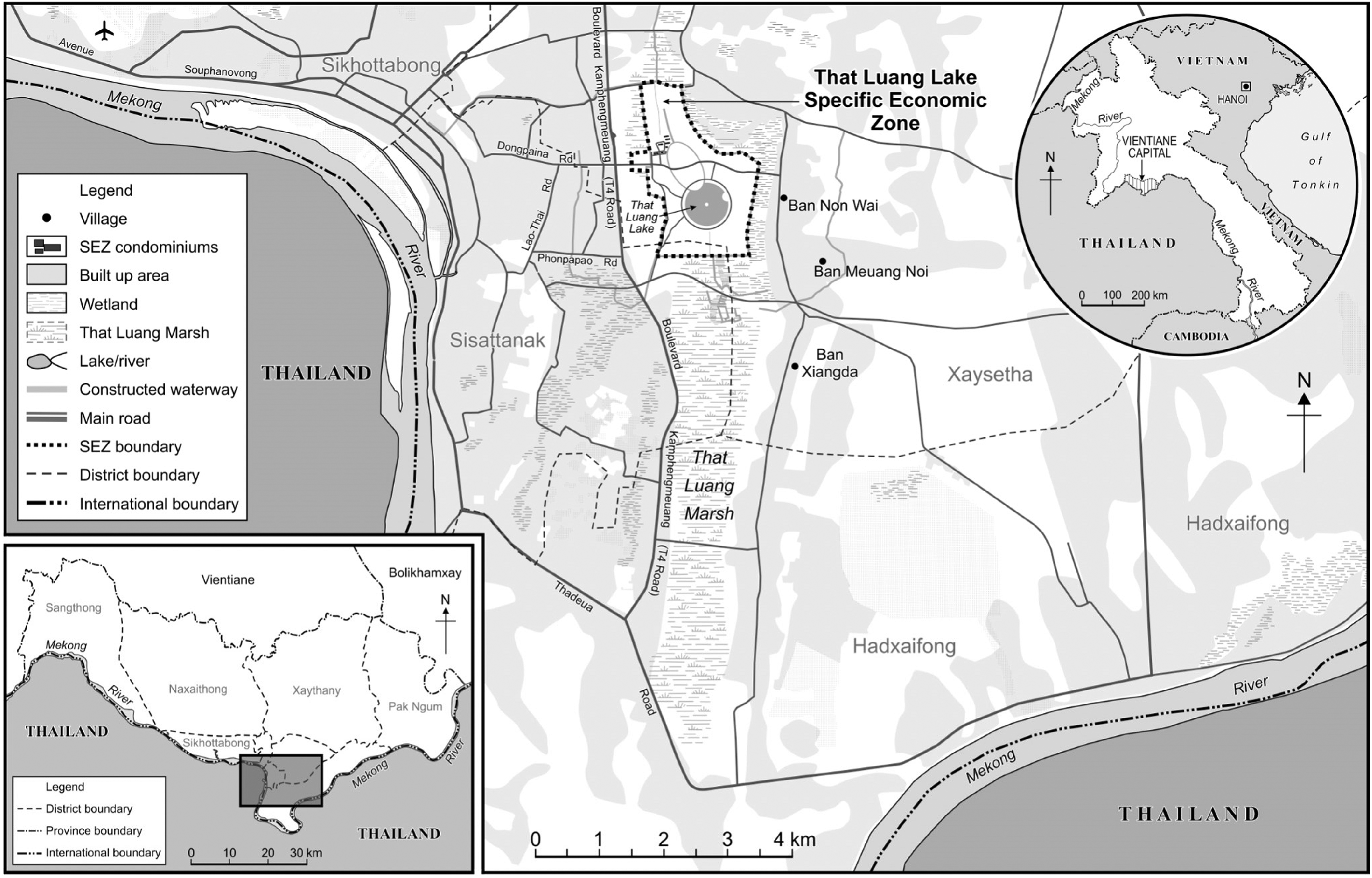
Map of the research area (That Luang Marsh) and field sites (Ban Non Wai, Ban Meuang Noi, and Ban Xiengda).
As the monsoon season arrived in 2013, local farmers experienced firsthand the ramifications of the land reclamation on their farming practices. Among them was Por Toui, a village elder, who at that time still retained a plot of paddy land abutting the SEZ. The project developers erected a two-meter-high earthen wall next to his property. This altered topography caused his paddy land to become easily inundated during the rainy season, with water pooling for days on end, instead of draining into the reservoir like before. To illustrate the severity of the situation, Por Toui invited us for a tour of his land several days after Vientiane had been soaked by heavy rains in April 2018 (see Figure 2). Almost two-thirds of the paddy fields were still under water, hindering rice cultivation. Reflecting on how the physical changes brought by the SEZ dislocated villagers from their once comfortable farming lives in general, Ai Seng aptly observed, “There is too much water in the rainy season, and too little water in the dry season.” Although Ai Seng had stopped farming due to these water-related challenges, Por Toui remained determined to harvest at least some rice from his land.
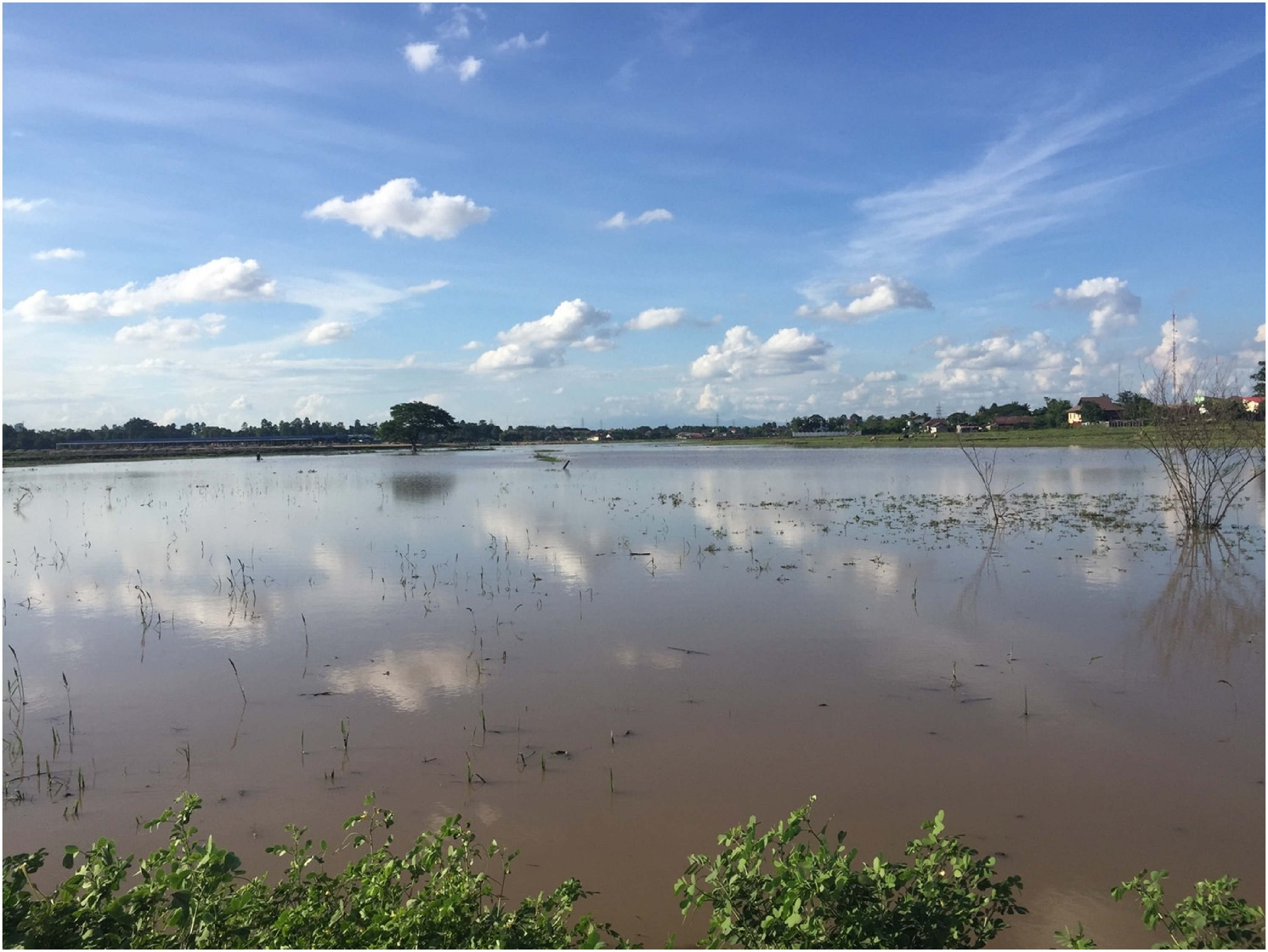
Flooded paddy field in BTL, April 2018 (photo taken by the first author).
Besides diminishing opportunities for sustaining livelihoods through sedentary farming, villagers also found themselves alienated from common resources that were once available for fishing and foraging. Land reclamation displaced the fertile wetland ecology, which supplied abundant aquatic resources to local communities. The year-round reservoir of BTL served as a life-giving cradle, enabling the reproduction of fish, water snails, morning glories, and other highly valuable plants and animals. These resources constituted not only vital sources of food that residents could collect to feed their families, but also commodities for extra cash income. One villager, Mae 12 Kesone, fondly remembered the joy of selling fish and snails from the wetland in the past. Prior to the establishment of the SEZ, there were a dozen naturally formed small ponds on her paddy land that were always brimming with fish. Every so often, affluent urbanites would visit to buy fish from her. She recalled, “I would pump water out from the ponds on my paddy and sell them the fish. It would not take long for new fish to fill up the ponds again.” Indeed, whenever the marsh was flooded with rainwater, fish from the reservoir would migrate to empty ponds and multiply. She could earn around 100,000 to 200,000 kip (US$12.5–25) each time by selling a pond full of fish.
The intensive construction activities undertaken to build the SEZ proved fatal for many aquatic species that once flourished in the ecosystem. Nothing illustrated the situation more poignantly than an encounter at Mae Kesone's home. She graciously invited us for lunch during fieldwork and served us a plate of grilled fingerlings, which she explained were all that remained for her to catch these days. The larger, economically valuable species, which thrived in water-rich environments, had vanished soon after the BTL's hydro-ecology was altered to accommodate the development of the SEZ.
The SEZ's transformation of the ecology of the BTL illustrates how large-scale land concessions can impact landscapes and livelihoods beyond their immediate boundaries (Baird and Fox, 2015). The subsequent material changes affected residents’ relation with land, particularly noticeable among those who were directly dispossessed by the SEZ. Even the most aggrieved in this group eventually relinquished their property claims, accepted compensation, and witnessed their paddy lands being transformed into a new economic zone. Meanwhile, others whose lands were spared from the SEZ's expropriation grappled with the challenges and opportunities presented by the material production of this real estate enclave.
The material basis of speculation
Wanfeng's construction activities initially involved dismantling the pre-existing irrigation system, dredging and deepening the central canal within BTL, and creating an artificial lake. This led to the drainage of water from the rest of the wetland, rendering it dry and suitable for further construction. Subsequently, the developer filled the land in the SEZ, elevated the terrain, and established its internal canal system connected to the lake. As discussed in the previous section, these activities had environmental consequences that undermined the agrarian use value of paddies surrounding the SEZ. However, they also stabilized the wetland for the purposes of real estate development, enabling the reclamation of individual plots without the threat of waterlogging and at a relatively low cost. This new material condition aligned with the interests of land investors and speculators and left farmers with little option but to view their land as real estate to be exchanged or developed.
These material transformations occurred as BTL was becoming a site of frenzied property speculation for several reasons. First, the arrival of the SEZ itself brought significant attention to the area, positioning it as a burgeoning hub of urban development in the city. The completion of a publicly accessible lake, complemented by surrounding sidewalks, roads, and landscaping, turned Wanfeng's project into a popular leisure space among the city's emerging middle-class residents (Bosoni et al., 2023). Additionally, a multi-lane road was constructed through the SEZ, connecting its western and eastern flanks. This thoroughfare, coupled with another east–west road located slightly south of the SEZ, transformed the BTL into a pivotal and accessible district of the city, linking key sections of Vientiane. Consequently, the BTL's evolving landscape has emerged as a geographically prime location, magnifying the prospective economic value of its land plots.
Households that were dispossessed directly by the SEZ had mostly moved away from the area by the time of our fieldwork. We encountered only one of such families that was able to marshal enough resource to purchase a new plot in the village to resettle themselves. The rest of the locals we met were peasants who retained land after the development of the SEZ and mostly possessed paddies in addition to their residential plots. For them, the new economic-socio-ecological configuration of BTL brought about by the SEZ not only eroded an old way of life, but also heralded new forms of economic survival. They increasingly shifted from farming to land trading, speculating on the rising exchange value of the land. Ai Seng succinctly pointed out this trend, noting “A lot of people started considering the option of selling land after irrigation conditions changed.” Neither entirely coercive nor voluntary, the trend reflected residents’ adaptative efforts to navigate a landscape undergoing dramatic transformation. Some plots sold off by peasants have been developed into private homes, schools, petrol stations, restaurants, apartments, and commercial spaces. Others were reclaimed before being subdivided into smaller plots for sale (refer to Figure 3). It was common for plots to circulate for multiple rounds on the market before being developed into urban property.
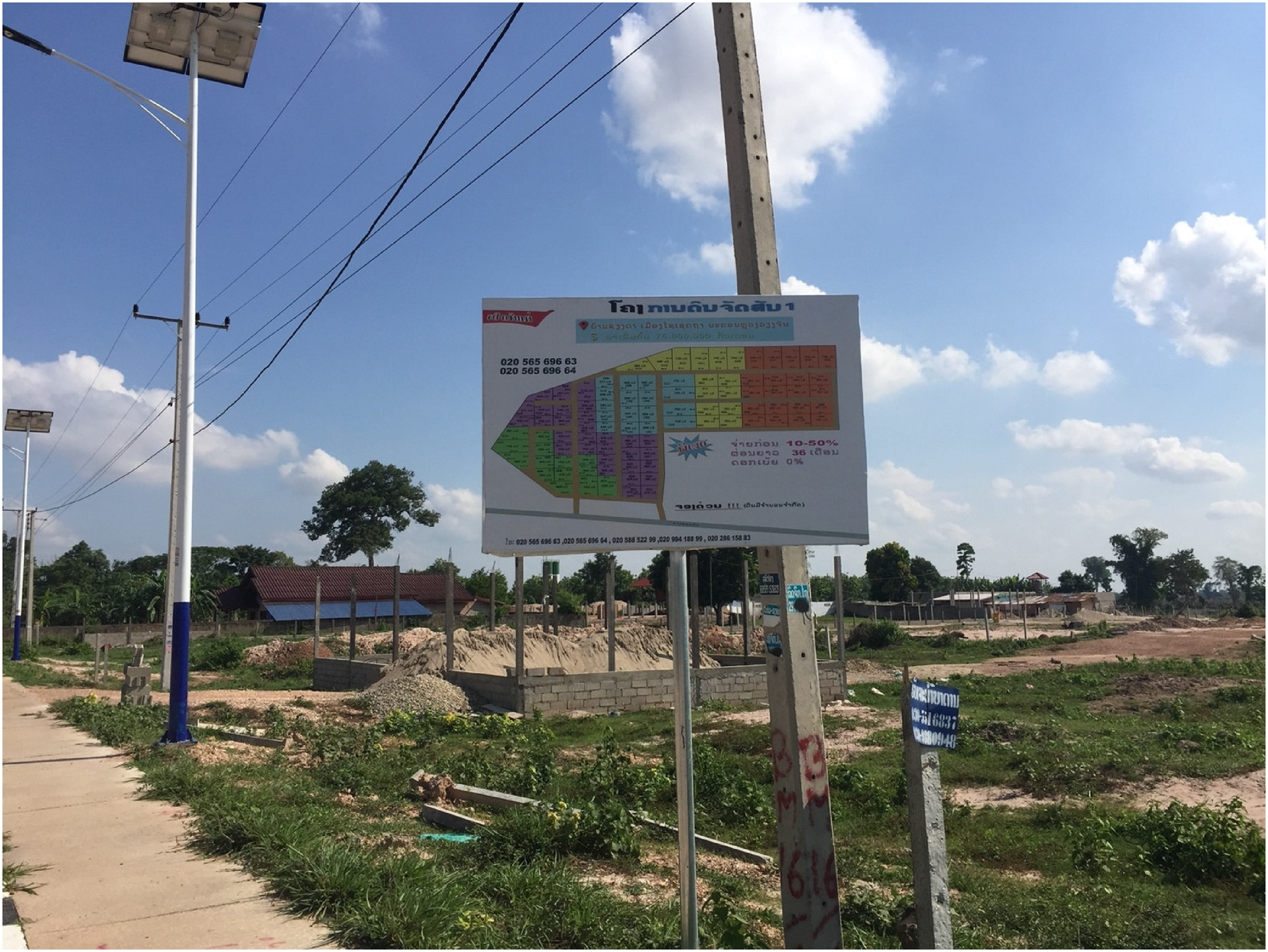
Land parceled into small pieces for sale by investors from outside the village (photo by first author).
From the outset, landed residents seemed to be well-positioned to capitalize on land trading and speculation. However, resourceful and experienced investors and developers in the local property market employed various tactics to negotiate advantageous deals. Consequently, there was a prevailing sentiment among villagers who had sold their plots that they had failed to fully realize the price difference between agricultural paddy land and its potential value as real estate.
Among them was Por Keo, a village elder who served as a primary liaison for our community-based fieldwork. Formerly the nai ban of his village, he possessed a comprehensive understanding of the history of property transactions related to the plots we encountered during our field surveys. Yet, he shared a personal experience where, in his own words, he was “cheated into” selling a plot of paddy adjacent to a road built south to the SEZ. While its value had escalated to between 300 and 400 US$/m2 by the time of our conversation, he had regrettably sold it for 50 US$/m2 5 years earlier. At that time, a broker dispatched by the road developer approached him with a claim that his plot was earmarked for appropriation for the road project and would be compensated at a low, state-determined rate. When the broker offered to buy it at a slightly elevated price, Por Keo jumped at the opportunity.
His experience revealed a common tactic politically connected real estate capitalists deployed to rush locals into land sales—the threat of land grabbing. Such developers presented documents declaring forced expropriation with seals from state bureaus and signatures of government officials. Unlike the Wanfeng Group, which enforced land expropriation directly through agents of the state, like low-ranking civil servants, investors and developers behind these real estate developments conducted the de facto land acquisition on their own. They leveraged the documents at hand to sow fear and trigger a panic sale among local landowners. Villagers who could better evaluate the legitimacy of the information presented to them were more likely to hold on to their plots. For instance, Por Keo's neighbor, a family headed by a strong-minded and educated young man working in a vocational school in Vientiane, did not succumb to repetitive harassments from brokers sent by the road developer. He was admired as a smart and capable man by Por Keo. Such figures were rare, though. Most of the villagers we encountered were confused by and anxious about these threats of land expropriation.
In addition to fearmongering, experienced developers and investors who came to BTL after Wanfeng also pressured residents into property deals through land reclamation. As an illustrative case, a Lao company strategically parked an excavator in a segment of the BTL where they had been actively buying land (refer to Figure 4). Distressed villagers reported that this machinery would be immediately put into operation each time the investor closed a new purchase. By selectively reclaiming individual paddy plots, the company effectively degraded the irrigation conditions of surrounding paddies. This tactic echoed the broader strategy employed by Wanfeng Group during the SEZ development, which incrementally distanced peasants from their agrarian livelihoods through the ecological changes precipitated during construction, albeit at a smaller scale. Unlike Wanfeng Group—which did not exploit the changing environment for further land acquisition in BTL—this Lao company astutely recognized how the unintended consequences of land reclamation could benefit them. These divergent approaches reflected how local capital, equipped with on-the-ground knowledge, was much more capable of devising flexible strategies to acquire land directly from the local community. As farming the neighboring lands was made increasingly untenable, more peasant landowners agreed to sell off their paddies. The looming threat of materially transforming the BTL's landscape—and subsequent steps taken to enact those changes—served as a tangible force pressuring residents into real estate transactions.
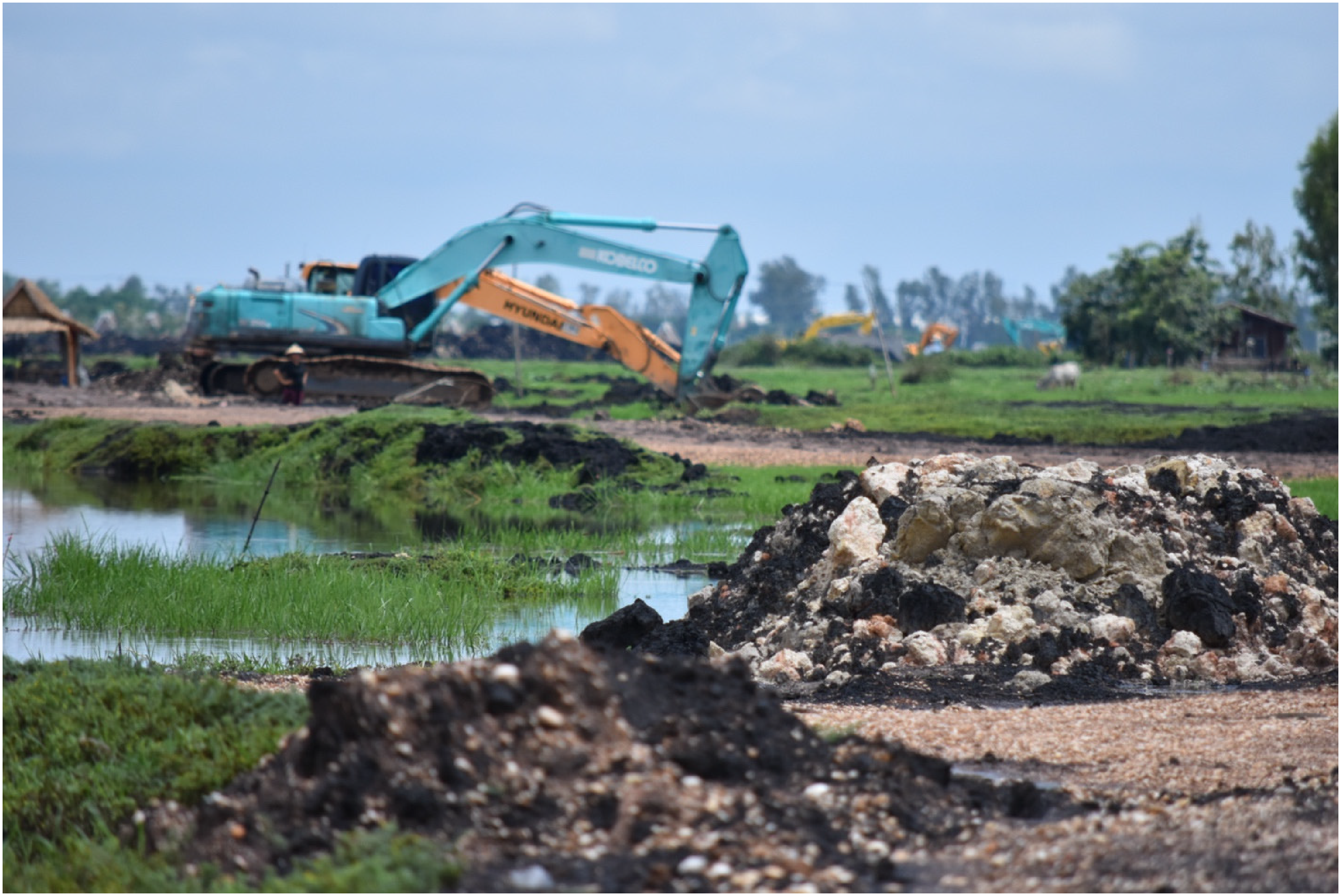
Excavators and piecemeal land reclamation in BTL (photo taken by the second author).
While some residents found themselves exploited by outsiders, others positioned themselves to capitalize on the unfolding changes. Those with adequate financial resources, business acumen, and land in prime locations began dabbling in small-scale property development. By the time of our fieldwork, sporadic residential and commercial real estate projects had emerged along the road south of the SEZ. One such project was an unassuming three-story apartment building erected by a villager named Ai Som on what was once his paddy field. Half of the units were occupied mainly by young people from rural areas who had migrated to the city for job opportunities or education. This rental venture represented Ai Som's primary investment for his family's future income. Hailing from an affluent village family—with a sister in civil service and his own career in the city's banking sector—Ai Som was well-placed to secure a loan for the construction of this building, which housed several rental units alongside space for his own family. However, individuals like Ai Som, who could marshal the necessary funds for such projects, were the exception. Most locals keen on entering the urban property market were restricted to land dealing—either selling their own paddies or brokering deals to earn commissions.
In certain instances, farmers who had previously been duped into selling their land below its potential value were more shrewd in negotiating deals for other land plots. A case in point is Por Keo. Toward the end of our fieldwork, he reached out to us, keen to leverage our ties with the Chinese business communities in Vientiane. Producing copies of a land title for a paddy field, he urged us to advertise the plot to potential Chinese investors, confidently stating, “For this plot, I want to sell at a unit price of 250–300 US$/m2.” However, we later learned from government officials about a detail Por Keo had omitted: his paddy field was situated within a preservation zone buffering the SEZ, which imposed additional restrictions on its potential conversion for construction. Informed investors would likely offer a reduced price for Por Keo's plot compared to others in the vicinity, given the regulatory uncertainties created by the preservation zone policy. If the government ever opted to repurpose the preservation zone for SEZ expansion or public infrastructure, the immediate owner could face expropriation at a minimal compensation rate. Yet, it appeared that Por Keo was counting on taking advantage of inexperienced Chinese investors unfamiliar with the property regulations in Laos. Through his experiences, Por Keo had learned from his mistakes, aiming to adeptly navigate the murky waters of a rapidly evolving property market.
It is important to clarify that the type of Chinese investors Por Keo targeted were those best described as petty developers and speculators. In a real estate frontier like Vientiane, the property market was not dominated by large, institutionalized actors like the Wanfeng Group, despite them being the most visible. A vast group of medium and small investors was also actively shaping market dynamics (Fauveaud, 2014). While villagers like Por Keo were negatively impacted by powerful actors like the Wanfeng Group and entrenched Lao elites, they often had an upper hand with petty foreign investors. Lacking insights into Vientiane's land governance and property market, such investors generally paid premiums for paddy fields and were susceptible to being scammed. This opened doors for savvy locals to profit handsomely in land dealing, as demonstrated by Por Keo's intent to source a Chinese buyer for his plot through us. Some of Por Keo's peers embarked on even bolder endeavors, like selling a single land parcel to multiple buyers and then absconding with the money. In their rush to profit from the property boom by locking in unsuspecting foreign speculators, these peasants not only sped up, but also reshaped the real estate enclosure of BTL.
The evolving materialities of the BTL laid the basis upon which land trading and speculation were taking place. Paddy fields, once fertile grounds for agriculture, were rendered unproductive as they dried up and were encircled by other plots being filled in and developed. Furthermore, the soaring economic value of the land made it highly attractive to sell. While in some cases outsiders schemed to acquire land at bargain prices, local residents adapted and learned to play the same game. Thus, peasants of the BTL were increasingly orienting their subjectivity toward land speculation. Neither forced nor voluntary, their pivot toward real estate market for a living was conditioned by the changing ground beneath their feet.
Conclusion
In this paper, we traced how the dialectical interplay between political economic forces and the materiality of nature has mediated the peri-urbanization in BTL. This wetland located at the eastern fringe of Vientiane was converted into a space for agrarian production and settlement during the socialist era of Laos. Its watery environment rendered it partially bypassed during the land titling processes in the 1990s, setting the stage for the subsequent state-led appropriation as the Lao government sought to turn land into capital amid intensified market reforms. When the Wanfeng Group developed its SEZ into the reservoir of BTL in the early 2010s, the wetland's ecology was dramatically altered. To drain and stabilize the wetland for construction, the irrigation system in BTL was dismantled, and massive land reclamation was conducted within the SEZ's boundary. As a result, paddies surrounding the SEZ became prone to flooding during the rainy season and experienced a shortage of irrigated water during the dry season. The SEZ's arrival also led to the destruction of the wetland's biodiversity, with vital aquatic resources for fishing and foraging disappearing. Consequently, peasants whose land was exempted from the SEZ's appropriation found the agrarian use value of their properties diminished.
While the new materiality of the wetland created by the SEZ's construction works constrained possibilities for agrarian livelihoods, it simultaneously aligned BTL with the interests of real estate capital. Managed flows of water enabled the technical and economic feasibilities of sporadic and small-scale reclamation of paddies outside of the SEZ. Coupled with the attention garnered by the SEZ and BTL's improved transportation connection with the city, investors and developers began flocking to the area, turning it into a center for property speculation. The situation prompted many local landholders who once hoped to continue with their semi-subsistence way of living to actively pursue income opportunities in the urban real estate market. The formation of such post-agrarian subjects blurred the line between coercion and voluntary submission that have hitherto structured debates on the encounter between peasantry and real estate capital (e.g. Gururani and Dasgupta, 2018; Kan, 2020; Leitner and Sheppard, 2018; Levien, 2013). It represents the formation of capitalistic relations from below, in which political economic and material changes reset livelihood options (Li, 2014a). In the post-SEZ property boom, the wetland's ecology was strategically exploited by experienced and resourceful speculators for land grabbing. By rapidly reclaiming land parcels upon acquisition, these actors pressured smallholders of surrounding paddies into selling their land. In short, the lively materialities of nature continued to play a crucial role in redirecting peasants toward real estate capital amid the ongoing urbanization of BTL.
Given that wetlands have been a primary target for land grabbing in recent urbanization processes across Asia, the dynamics we observed in BTL contain generalizable insights (Collins, 2017; Ranganathan and Doshi, 2018; Shatkin, 2019). Through a synthetic and dialectical approach that integrates relational Marxism with new materiality, the study illustrates the critical importance of interactions among nature, state, capital, and community in mediating the enclosure of peri-urban wetlands in Asia. Doing so enables a deeper understanding of processes of dispossession, land exchange and real estate development, and the emergence of post-agrarian subjectivities.
Highlights
This paper presents an empirical case of wetland enclosure in peri-urban Vientiane, in which real estate development transformed the ecology of the entire wetland and induced further dispossession. Theoretically, the paper takes a synthetic political ecological approach that integrates relational Marxism with influences from new materialism to examine changing ecological landscapes and related livelihoods. By highlighting how peasants in the agrarian wetland were influenced to pursue land sepculation following its enclosure, the paper shows the agentive role of nature in shaping post-agrarian subjectivity and dynamics of peri-urbanization in Laos.
Footnotes
Declaration of conflicting interests
The authors declared no potential conflicts of interest with respect to the research, authorship, and/or publication of this article.
Funding
The authors received no financial support for the research, authorship, and/or publication of this article.