
Abstract
Deep brines in the Qaidam Basin (QB, northern Tibetan Plateau) hold abundant K, Li, B, Br and Sr resources with great exploitation potential. Nevertheless, mechanisms controlling spatial enrichment heterogeneity of these valuable elements remain unclear, restricting efficient brine resource exploration and utilisation. This study systematically integrated hydrogeochemical parameters, multi-isotope (H–O–B–Li–He) signatures and temperature data acquired from 55 deep boreholes to reveal elemental differentiation laws and formation controlling factors of deep brines. Quantitative results show central basin brines yield average concentrations of 0.36–1.12 g/L K (avg = 0.73 g/L), 108–495 mg/L B (avg = 252 mg/L), 27–114 mg/L Li (avg = 90 mg/L), 38–83 mg/L Br (avg = 59 mg/L) and 142–381 mg/L Sr (avg = 245 mg/L), all distinctly lower than those in western brines. Western brine isotopic features (δD–δ18O patterns) reflect predominant water–rock interaction, while central brines experience combined water–rock reaction and evaporation concentration. Helium isotopes verify crustal fluid origin for central brines and mantle-derived magmatic fluid contribution in the western basin. High geothermal anomalies are exclusively identified in the Nanyishan–Dafengshan and Yahu–Hongsanhan anticlinal zones, which facilitate B and Li migration and accumulation. Lithologic properties at basin margins dominate Li/B ratio variation in central brines, whereas K, Br and Sr distribute evenly and are mainly regulated by lake depocentre migration. Geothermal condition, fluid source and sedimentary evolution jointly shape regional brine elemental discrepancy. Different fluid genesis models are confirmed between western and central basin brines. Distinct from prior research focusing on a single element or partial local area, this work clarifies the coupled control of fluid source, geothermal activity and depositional evolution on multi-element spatial heterogeneity across the whole basin. The quantitative dataset and genetic mechanism understanding offer practical guidance for targeted deep brine prospecting and comprehensive resource development in the QB.
Keywords
Introduction
The soaring demand for boron (B), lithium (Li), potassium (K), bromine (Br) and strontium (Sr), driven by their critical roles in advanced materials and electric vehicle technologies, has spurred urgent global research into their enrichment mechanisms.1–3 As primary sources of these strategic elements, closed-basin brines offer unique economic advantages with minimal environmental impact, underpinning their dominance in sustainable supply chains.3–5 In the northern Tibetan Plateau (TP), the Cenozoic India–Eurasia collision formed a series of hydrologically closed basins.6–8 This tectonic framework, combined with an arid climate, provided the essential setting for evaporative concentration and the formation of Li- and B-enriched brines and evaporites.6,8
As the largest intramontane closed basin within the northern TP, the Qaidam Basin (QB) provides an ideal setting to investigate the genesis of Li–B-rich brines under coupled tectonic and climatic forcing.1,2,9 However, the QB exhibits pronounced spatial heterogeneity in resource element (K, B, Li, Br and Sr) distribution. Specifically, B-enriched salt lakes concentrate in the northern basin (e.g. Da/Qiao Qaidam Lakes),10,11 while Li-rich brine deposits dominate the southern basin (e.g. Yiliping, East/West Taijinaer Lakes).1,2 While modern lake systems are linked to contemporary hydrology and hydrothermal inputs,6,12,13 excessive exploitation threatens the sustained supply of B and Li, driving the exploration for deep brine resources.
The western QB hosts prolific B- and Li-rich deep brines (e.g. oilfield and anticlinal brines; depth >500 m), showcasing significant potential as a reservoir for critical metals.9,14–17 Previous studies attribute their formation to water–rock interaction, evaporative concentration and geothermal fluid mixing.8,9,15–17 Isotopic evidence (δD, δ18O) links deep brines to geothermal fluid sources. 17 Recently, highly elevated B and Li concentrations have been identified in the central Yahu anticline, linked to deep water–rock interaction and ion exchange.9,18 However, existing studies are largely confined to the western QB, leaving the central region and the controlling mechanisms of abnormal geothermal gradients poorly constrained. This gap leaves two key questions unresolved: (1) whether the spatial distribution of deep geothermal anomalies in the QB correlates with boron–lithium enrichment zones of deep brines; and (2) whether thermal conditions dominate the enrichment of K–B–Li–Br–Sr across the west-central QB.
Accordingly, this study analyses major ions, trace elements (B, Li+) and H–O–He isotopes of six deep brine samples from three key locations (Yahu, Jianshishan, Hongsanhan) in the central basin. Borehole temperature measurements are conducted to establish regional geothermal isotherm maps. Combining these new datasets with published data (e.g. H–O–Li–B isotopes), this study clarifies how deep geothermal anomalies govern B–Li enrichment and explores the spatial differentiation mechanism of K, Sr and Br enrichment in the QB.
Geological setting
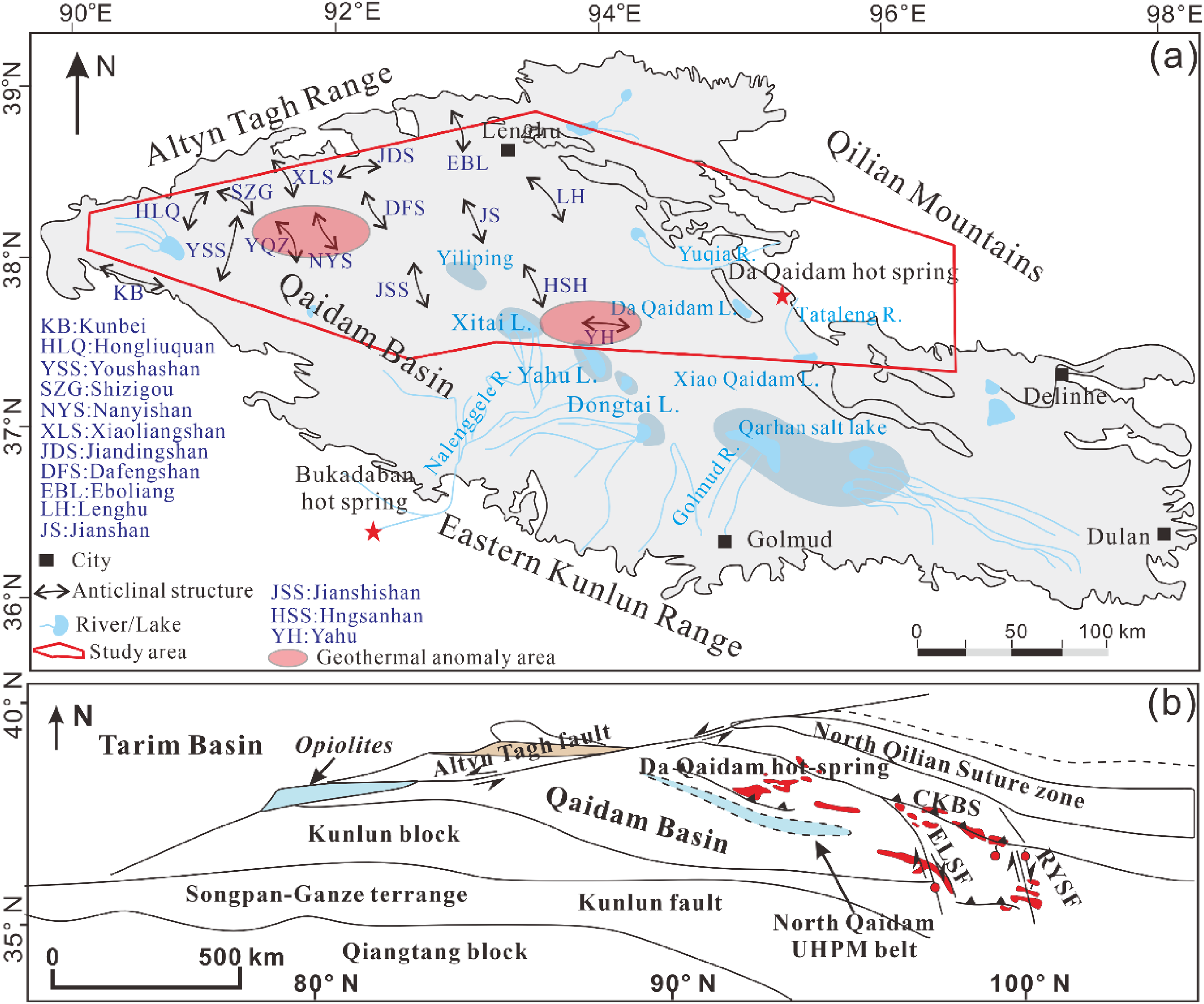
The QB, a typical rhombic closed inland basin in the northeastern TP, strikes NWW–SEE with an area of ∼1.2 × 10⁵ km2.19–21 It is bounded by the Qilian, Altyn Tagh and East Kunlun mountains to the north, west and south, respectively (Figure 1(a)). The northern basin shows a NW-high, SE-low topographic gradient governed mainly by Cenozoic tectonics (Figure 1(b)). Widespread folding in western and central QB has formed a well-developed fold belt dominated by anticlines and synclines (Figure 1(a)). Cenozoic tectonism not only deformed basin strata but also enhanced erosion of adjacent orogens, delivering voluminous clastic sediments to the basin. These deposits accumulated to form thick successions (>5000 m locally), which constitute key brine reservoirs for deep subsurface brine systems.22–24

(a) Topography and geomorphology, division of deep brine blocks and sampling locations of deep brine samples in the Qaidam Basin (A: southwestern basin, including the Gas, Kunbei and Youshashan areas; B: western basin, including the Nanyishan, Xiaoliangshan and Dafengshan areas; C: central basin, including the Yahu, Hongsanhuan and Jianshishan areas; D: northern basin, including the Lenghu and Eboliang areas); (b) Geological map of the Qaidam Basin (modified from a previous study 24 ).
Pore-type brines hosted in Quaternary salt layers and marginal clastic sediments and distributed near the surface of salt lakes are classified as intercrystalline brines. 11 In contrast, deep brines are dominated by structurally trapped anticlinal brines and oilfield-associated brines. 17 Within the various sub-basin tectonic units of the QB, Li-rich intercrystalline brines are mainly concentrated in the Sanhu Depression, including the Yiliping, East Taijinar, West Taijinar and Bieletan areas. In sharp contrast, B-rich brines are predominantly enriched in the Da Qaidam and Xiao Qaidam salt lake system.1,11 Deep brines in the western QB (including oilfield brines and structurally hosted anticlinal brines) exhibit significantly elevated B and Li concentrations, characterised by pronounced resource enrichment.16,17 However, deep brines in other parts of the basin show considerable differences in B and Li contents. Deep brine-hosting areas are classified into four zones (Figure 1(a)) to analyse regional heterogeneous enrichment of resource elements: Zone A: southwestern basin (Gasi, Kunbei, Youshashan, Shizigou); Zone B: western basin (Nanyishan, Youquanzi, Youdunzi, Kaitemilike, Dafengshan, Xiaoliangshan, Jiandingshan); Zone C: northern basin (Lenghu, Eboliang); Zone D: central basin (Yahu, Hongsanhuan, Jianshan, Jianshishan).
The enrichment of B and Li in intercrystalline brines and the development of evaporitic saline–alkali mounds in the QB are dominated by its extreme aridity (Figure 1(b)). As one of the driest areas in Central Asia, annual precipitation is <100 mm across the basin and only 25–40 mm in the centre, while potential evaporation is more than 20 times higher.25,26 Extreme aridity regulates the regional hydrology, driving brine evaporation and concentration and thus the progressive enrichment of salts and resource elements. Despite overall aridity, perennial rivers are well developed in the east, including the Nalinggele, Golmud, Yuqia and Tataleng rivers (Figure 1(a)). Perennial salt lakes are sustained by runoff along the northern and southern margins, whereas the western basin hosts widespread dry salt flats due to limited recharge. The eastern basin, fed by stable perennial rivers, maintains large, persistent perennial salt lakes (Figure 1(b)).
Materials and methods
Sampling and analytical methods
In April 2025, a total of six deep brine samples (anticlinal brines) were collected from the Jianshishan (JSS), Yahu (YH) and Hongsanhan (HSH) anticlinal structural belts, which are located in the central QB. The specific sampling localities are illustrated in Figure 1(a). To ensure the reliability and representativeness of the brine samples, all deep brine aliquots were obtained directly from purpose-built brine exploration boreholes that intersect shallow brine-bearing horizons, thereby eliminating the potential for surface-derived contamination. Temperatures of the deep brine samples collected in this study vary from 55 to 88 °C. Prior to formal sampling, high-density polyethylene (HDPE) bottles were preconditioned by rinsing three times with raw brine from the corresponding sampling sites to eliminate potential cross-contamination. Subsequently, the collected brine samples were filtered through 0.45 μm cellulose acetate membrane filters to remove suspended particulate matter, and the filtrates were immediately transferred into pre-cleaned 200 mL HDPE containers.
Hydrochemical analyses of the deep brine samples were conducted following the standard protocols established by the Qinghai Institute of Salt Lakes, Chinese Academy of Sciences (QISL, CAS) (procedures established by Qinghai Institute of Salt Lakes 1988). Concentrations of major cations (K+, Na+, Ca2+, Mg2+) and boron (B) were determined by inductively coupled plasma optical emission spectrometry (ICP-OES), with a relative standard deviation (RSD) of less than 5%. For major anions, chloride (Cl−) was analysed via ICP-OES (RSD < 5%), whereas carbonate (CO₃2−) and bicarbonate (HCO₃−) were quantified by acid–base titration with hydrochloric acid (HCl), achieving an analytical precision (RSD) of better than 0.3%. Lithium (Li+) concentrations were measured using inductively coupled plasma mass spectrometry (ICP-MS), with an RSD of less than 3%.
Hydrogen and oxygen (H–O) isotopic compositions of the brine samples were analysed at the Beijing Research Institute of Uranium Geology. Isotope ratios were determined using a Thermo Fisher Scientific MAT 253 isotope ratio mass spectrometer (IRMS), based on the zinc reduction method for H₂ and the CO₂–H₂O equilibrium method for CO₂. All isotopic data were normalised to the Vienna Standard Mean Ocean Water (V-SMOW) reference scale, with analytical uncertainties of ±1‰ for δD and ±0.2‰ for δ18O, respectively.9,11
Prior to field deployment for drilling operations, the helium (He) mass spectrometer underwent rigorous laboratory calibration. Optimal ionisation efficiency was attained at a 70 eV electron source potential
27
and retained for all subsequent analyses. Characterisation of the spectrometer's dynamic background identified isobaric interference between 12C₃+ and 4He+ ions. To quantify hydrocarbon and CO₂ interference effects, calibration gas mixtures were prepared as follows: hydrocarbon blend (CH₄: 14.9 ppm; C₂H₆: 11.9 ppm; C₃H₆: 9.91 ppm; n-C₄H₁₀: 2.45 ppm; n-C₅H₁₂: 2.55 ppm, balanced with N₂) and CO₂ gas (500 ppm in N₂). Test results showed that 12C₃+ signals from these species remained at background levels, indicating negligible interference with 4He+ detection. An 11-point external calibration curve (11.5–500 ppm He in N₂) was established by decuplicate measurements per concentration, with excellent linearity (y = 26.163x + 84.118, R2 = 0.99903; x = He concentration in ppm, y = spectrometer signal intensity). Precision analysis showed that the RSD of He concentration measurements varied with concentration: 5.88% (maximum) at 11.5 ppm He, <3% for concentrations > 100 ppm He and <2% for concentrations > 200 ppm He. Continuous 57-h operation with an 85 ppm He standard displayed linear signal attenuation (R2 = 0.93925), requiring daily drift correction in field measurements. Atmospheric He contamination (5.24 ppm, ambient air background) in mud gas samples was corrected using the method of Lu et al.
28
:
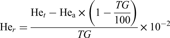
where Her: original helium volume content of the formation fluid (vol%); Het: measured helium concentration of the sample (ppm); Hea: atmospheric helium background concentration (5.24 ppm); TG: total hydrocarbon volume content of the sample, determined by gas chromatography (GC) (vol%).
Isotherm delineation across depth profiles and geothermal gradient estimation of deep brines
Temperature datasets from 55 oil and deep brine exploration boreholes are compiled to characterise subsurface thermal distribution across western and central QB. These data were obtained from the unpublished Geothermal Survey Report of the Qinghai Qaidam Comprehensive Geological and Mineral Exploration Institute. 29 These measurements are applied to establish subsurface isotherms at 1000 m, 2000 m and 3000 m depths for exploring the geothermal regime of the QB. Our results provide key constraints for evaluating the basin's geothermal potential and delineating low-temperature geothermal anomalies.
Results
Hydrochemistry
Test results for major and trace elements in deep brines from the Yahu, Hongsanhan and Jianshishan areas in the QB are listed in Table 1. The results demonstrate that deep brines in the central basin are dominated by Na+ and Cl−, followed by Ca2+. The concentrations of K+, Mg2+, SO₄2− and HCO₃− are generally low, and CO₃2− is either below detection limit or present at extremely low levels. The Piper trilinear diagram reveals that deep brines in the study area share similar hydrochemical compositional with other typical deep brines in the basin, all falling into the Na–Cl water type zone (Figure 2(a)). In contrast, deep brines from other parts of the central basin exhibit relatively high HCO₃− concentrations and are mainly distributed in the Ca–Na–HCO₃ and Na–HCO₃ water type fields (Figure 2(a)), indicating that carbonate minerals exert a significant control on the hydrochemical compositions of regional deep brines. 17 Some deep brines in the western and northern parts of the basin plot in the Ca–Cl water type field, characterised by high Ca2+ background concentrations.
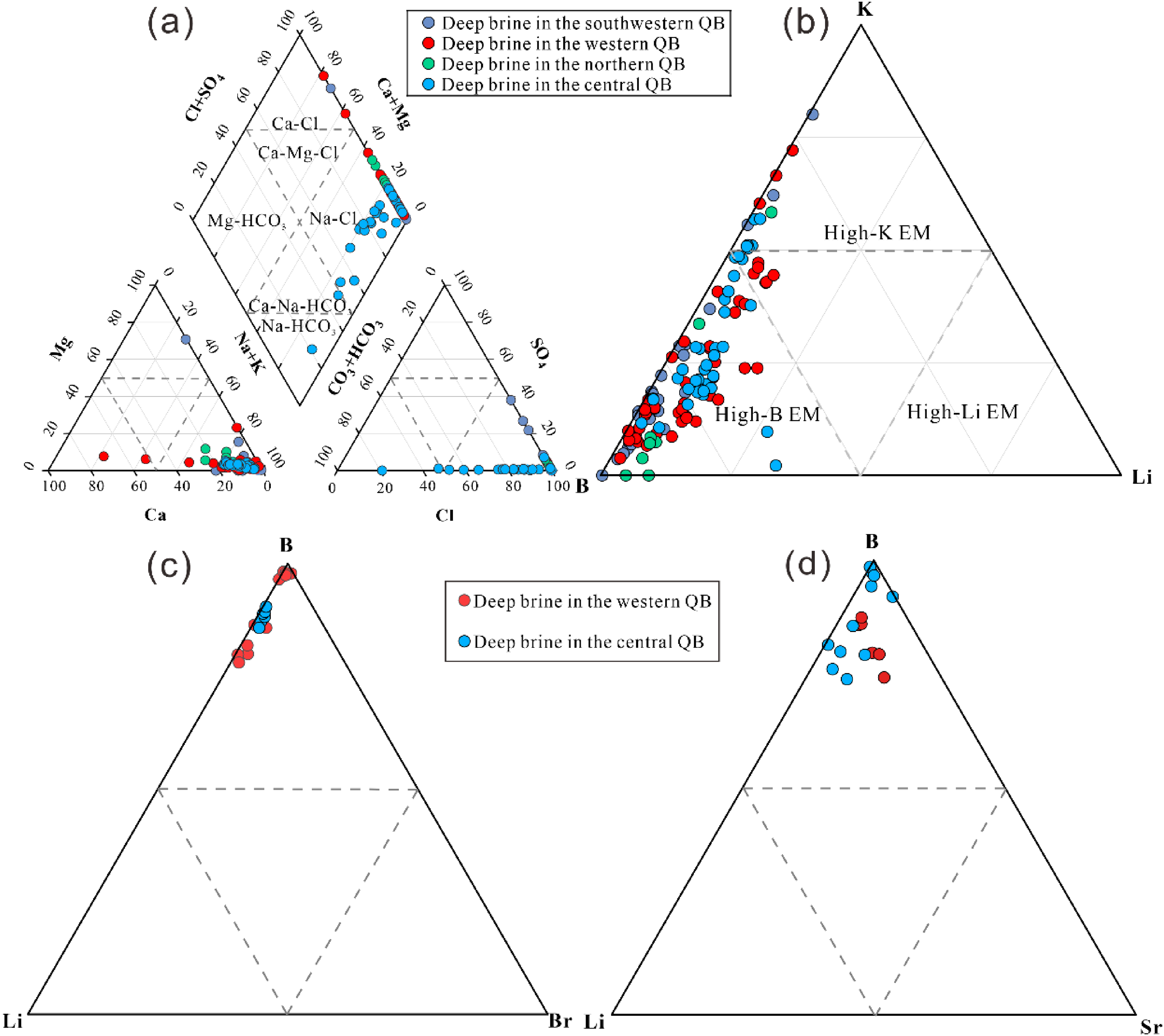
(a) Piper diagram of hydrochemical compositions for deep brines in different regions of the Qaidam Basin; (b) K–Li–B ternary equivalent diagram; (c) Br–Li–B ternary equivalent diagram for brines in western and central Qaidam; (d) Sr–Li–B ternary equivalent diagram (Data sources from previous studies9,16–18 and this study).
The chemical composition of deep brine in the central part of the Qaidam Basin.
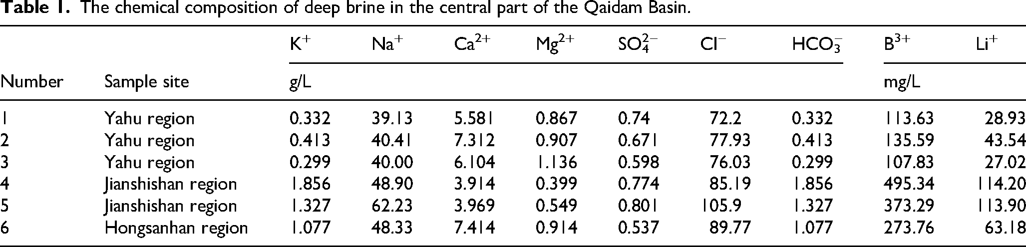
For trace elements, Li+ concentrations in deep brines of the central basin range from 29 to 114 mg/L, with a mean value of 65 mg/L; B3+ concentrations vary from 108 to 495 mg/L, with an average of 295 mg/L (Table 1). Compared with deep brines in other regions, Li and B contents in this area are higher than those in the southwestern (Bave = 167 mg/L; Liave = 12 mg/L) and northern parts (Bave = 33 mg/L; Liave = 4 mg/L) of the basin but lower than those in the western QB (Bave = 534 mg/L; Liave = 103 mg/L). 9 In summary, deep brines in the QB are generally enriched in boron. Local brines in the western basin are enriched in potassium, whereas those in the central basin are relatively enriched in lithium. These distribution patterns are well illustrated in the K–B–Li triangular equivalent diagram (Figure 2(b)).
H–O–He isotopic composition
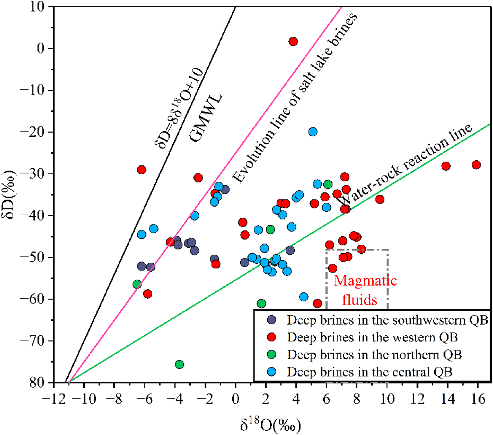
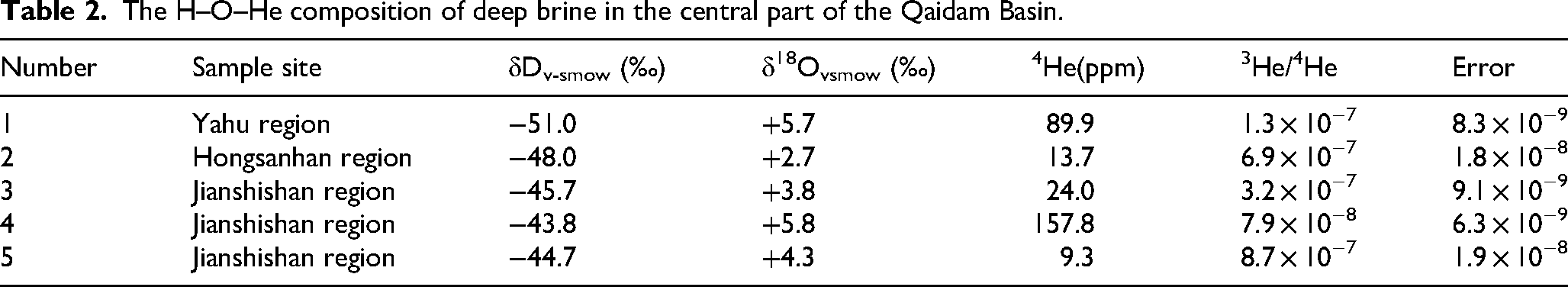
The δD, δ18O and He isotopic compositions of deep brines from the central areas of Yahu, Hongsanhan and Jianshishan in the QB are presented in Table 2. In this central basin area, δD values range from −51.0‰ to −43.8‰ and δ18O values range from +2.7‰ to +5.8‰. On the δD–δ18O correlation plot (Figure 3), these samples plot on both sides of the deep brine evolution line, which may be related to water–rock interactions within the deep brine reservoir. 17 For noble gases in deep brines from the central area, the 4He concentrations vary from 9.3 to 157.8 ppm with a mean value of 58.94 ppm, and the 3He/4He ratios range from 7.9 × 10⁻⁸ to 8.7 × 10⁻⁷ (Table 2).
The H–O–He composition of deep brine in the central part of the Qaidam Basin.
Discussion
Spatial heterogeneity of resource elements in deep brines of the Qaidam Basin
Previous studies reveal deep brines in the QB are rich in K, Li, B, Br and Sr, possessing favourable resource conditions and great exploitation potential. 8 Intense folding and deformation of basin strata resulted from multi-stage Cenozoic tectonic activities, generating abundant anticlines and synclines.6,22,24,30 Widely distributed across the west-central basin, anticlines show obvious regional discrepancies under topographic and burial constraints (Figure 1(a)), thereby causing prominent spatial heterogeneity of ore-forming element enrichment.
Deep brines in western QB (Nanyishan, Xiaoliangshan, Dafengshan) are collectively enriched in K, Li, B, Br and Sr. B and Li reach peak concentrations of 44–1301 mg/L and 6–238 mg/L respectively, markedly exceeding levels of modern Li–B salt lake brines and commercial exploitation thresholds.9,17 This zone also contains abundant K (0.60–8.50 g/L), Br (31–534 mg/L) and Sr (8–5230 mg/L).16,17 Central basin brines (Yahu, Hongsanhan, Jianshishan) are primarily enriched in Li and B, with partial samples meeting or approaching industrial grades, alongside Br (38–83 mg/L) and Sr (142–381 mg/L) 18 ; this study). By comparison, northern and southwestern basin brines only feature low Li–B contents, with overall elemental concentrations and resource grades inferior to those in western and central areas.
Element equivalent values show more evident spatial variation than discrete mass concentrations. In central QB, B and Li concentrations range 44–417 mg/L and 6–159 mg/L, 18 presenting weaker Li enrichment than the western area. The K–B–Li ternary plot (Figure 2(b)) shows that samples far from the B-rich endmember are relatively Li-rich, mostly derived from central basin brines. This pattern likely results from mixing between deep brines and infiltrated surface saline lake water. 9 In the B–Li–Br diagram (Figure 2(c)), partial samples approach the B-rich endmember, some overlap central basin data, and others depart from this domain, while Br equivalents lack regular variation. Western and central brines generally converge towards high-B characteristics. The B–Li–Sr ternary plot (Figure 2(d)) displays consistent distribution features. Western and central samples occupy a broad range; western brines trend towards high-Sr composition, and all samples are controlled by B-rich endmember background. Overall, boron acts as the predominant resource element in basin deep brines. Its geochemical valence properties and regional B-rich material sources together control endmember mixing processes. 31
Statistical analysis shows no obvious disparity in major ion contents between western and central QB deep brines. The Na+ and Mg2+ dominate cations, and Cl− is the primary anion (Figure 2(a)), indicating evaporation enriches these ions. Furthermore, all deep brine samples—collected from anticlines in the western (Nanyishan, Xiaoliangshan, Dafengshan) and central (Yahu, Jianshishan, Hongsanhan) QB—fall within the Na–Cl field of the Piper diagram (Figure 2(a)), exhibiting elevated Na+ and Cl− concentrations. This geochemical signature indicates that the hydrochemical evolution of the deep brines has progressed to an advanced stage.6,9 In contrast to the major ions, concentrations of the trace elements B and Li in deep brines from the western and central QB exhibit statistically significant differences. Distinct regional differences exist in trace B and Li concentrations. Central brines have B of 108–495 mg/L (average 252 mg/L) and Li of 27–114 mg/L (average 90 mg/L), lower than western counterparts (average B 607 mg/L, Li 102 mg/L), and western B content presents wider variation (Table 1).9,17 The K–B–Li ternary diagram (Figure 2(b)) further verifies this trend. Central samples mainly gather in the high-B zone, while western samples scatter across high-B and high-K domains with higher and more variable B–Li contents. These characteristics imply complex brine origins controlled by water–rock interaction, evaporation and deep geothermal fluid mixing.9,15–17 The source and enrichment mechanism of B and Li in central brines still require further exploration.
Geothermal gradient anomalies in the Qaidam Basin identified from temperature contour lines
Previous studies have consistently demonstrated that high-temperature water–rock interaction is a key factor controlling the geochemical compositions of deep brines,9,32–36 a process largely driven by deep geothermal fluids. A systematic investigation of zones with anomalous geothermal gradients, therefore, plays a pivotal role in deciphering the spatial distribution and enrichment mechanisms of B and Li in deep brines within the QB. As documented in previous studies, δD–δ18O compositions of deep brines from Nanyishan, Xiaoliangshan and Dafengshan (western QB) plot within the isotopic field of magmatic fluids (Figure 3), indicating that ascending geothermal fluids exerted a dominant control on the genesis and evolution of these brines.9,17,37 In contrast, δD and δ18O values of deep brines from the central basin (Yahu, Hongsanhan and Jianshishan anticline belts) scatter on both sides of the evolutionary trend for deep brines (Figure 3), implying an absence of significant geothermal anomalies in the central anticline belt.
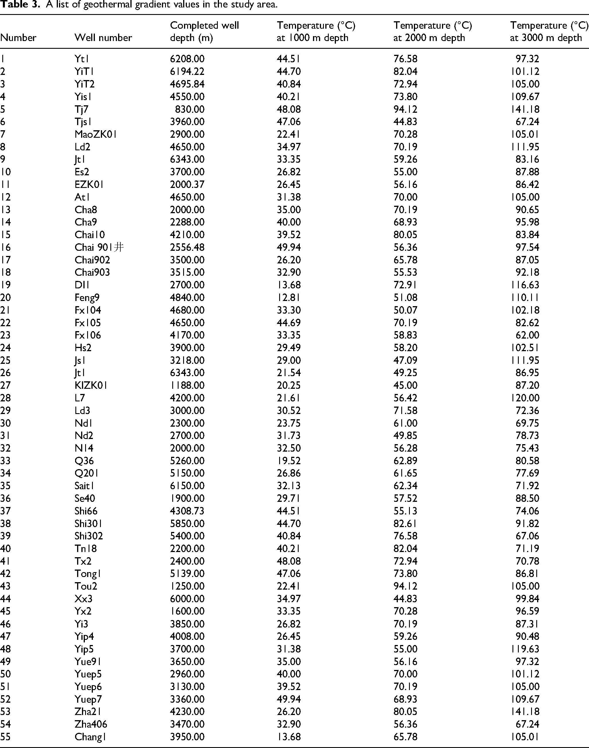
Han et al. 18 estimated reservoir temperatures of deep brines in the central basin at 110.5–152.8 °C using the Mg-corrected Na–K–Ca cation geothermometer. For the western basin, reservoir temperatures inverted using multiple cation geothermometers (Na–K, Mg–Li and Na–Li) range from 100 to 200 °C. 9 Although cation geothermometers have been widely applied to constrain brine temperatures in the region, such estimates may not reliably reflect the original reservoir conditions of primary deep brines. This is because cation ratios can be readily modified by intense late-stage water–rock interactions, mixing and recharge with shallow salt lake brines, as well as sampling bias towards boreholes targeting Li–B-rich industrial brines.
This study systematically compiled measured geothermal data at burial depths of 1000 m, 2000 m and 3000 m from 55 boreholes targeting oil–gas reservoirs and deep brine exploration (Table 3). Although borehole temperature measurements cannot fully represent the in situ thermal conditions of primary brine reservoirs, they objectively delineate the regional distribution of geothermal anomalies across the QB, providing key constraints for elucidating how high-temperature water–rock interactions control Li and B enrichment in deep brines. Based on depth-stratified borehole temperatures, isothermal maps were constructed to identify prominent geothermal anomaly zones at each depth interval (Figure 4). At 1000 m (Figure 4(a)), the central–western QB is characterised by an overall elevated geothermal background, with formation temperatures generally exceeding 34 °C in the Xian-shuiquan, Ganchaigou, Nanyishan and Taijinar Lake areas. Two distinct geothermal anomalies occur in western Nanyishan and eastern Taijinar Lake, where temperatures at 1000 m exceed 40 °C and reach a maximum of 48.08 °C. In contrast, temperatures in the northwestern Lenghu, Eboliang, Shizigou and Youshashan areas are relatively low, ranging from 26 to 34 °C. At 2000 m (Figure 4(b)), the average basin-wide temperature is approximately 70 °C. Prominent thermal anomalies are concentrated in two belts: (1) western blocks including Nanyishan, Dafengshan and Jiandingshan and (2) the Yahu–eastern Taijinair Lake area, both bounded by the 70 °C isotherm. Temperatures in Nanyishan exceed 80 °C, with a maximum of 82.61 °C recorded in the Changtiao-1 Well. By comparison, temperatures in the northwestern Ganchaigou, Huatugou and Shizigou areas, as well as the northeastern Lenghu and Mahai sub-basin, are lower, generally between 50 and 65 °C. At 3000 m (Figure 4(c)), extensive geothermal anomalies (>100 °C) are developed in western QB, most notably in Dafengshan, Jianshishan and the western Jianding block, where formation temperatures commonly exceed 110 °C. A stable high-temperature centre (>100 °C) also occurs across western Nanyishan and the central Sanhu Depression. In comparison, temperatures in Eboliang, Lenghu, Shizigou and Youshashan remain below 90 °C.

Geothermal contour maps at burial depths of 1000 m (a), 2000 m (b) and 3000 m (c) in the Qaidam Basin.
A list of geothermal gradient values in the study area.
Furthermore, the heat source of the Yahu anticline belt can be further constrained using dissolved helium (He) isotopic compositions of deep brines. Mantle helium contributions were calculated using the following equation
34
: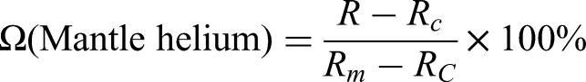
where R: ratio of the sample (Table 2); Rc: crustal ratio; Rm: mantle ratio.
Isotopic analyses of deep brine samples from boreholes in the Yahu anticline belt yielded a 3He/4He ratio of 2.31 × 10⁻⁷. When compared to the atmospheric 3He/4He ratio of 1.4 × 10⁻⁶, this translates to a value of 0.17 Ra (where Ra = atmospheric 3He/4He ratio). According to published global datasets, typical crustal-derived fluids exhibit 3He/4He ratios of 0.01–0.05 Ra, whereas mantle-derived fluids are characterised by ratios of 6–9 Ra. 34 These He isotopic results indicate that the conductive geothermal system of the QB is predominantly crust-dominated, yet contains a minor mantle-derived component, distinctly exhibiting a crust-mantle binary mixing signature for the heat source of the Yahu anticline belt. The crustal 3He/4He ratio endmember is 2 × 10⁻⁸, whereas the mantle-derived endmember is 1.1 × 10⁻⁵. 38 Accordingly, calculations reveal that the mantle-derived helium contribution to the Yahu anticline belt is 0.19%, with the crustal component accounting for 99.81% – confirming a predominantly crustal source with negligible mantle input (Geothermal Survey Report of the Da Qaidam-Mangya Region in Qinghai Province).
In summary, integrated analysis of geothermal isotherms at 1000 m, 2000 m and 3000 m, combined with cation geothermometry of deep brine reservoirs, delineates pronounced geothermal anomalies across the basin. Two prominent high-temperature zones are identified: (1) the Nanyishan–Dafengshan anticline belt and (2) the Yahu–Hongsanhan anticline belt, both exhibiting thermal characteristics consistent with active hydrothermal systems. In addition, anticline structural zones in the western QB, including Nanyishan, Xiaoliangshan and Dafengshan, as well as the central Yahu and Hongsanhan areas, are enriched in B and Li resources. These zones coincide with the previously identified anomalous geothermal gradient regions. Nevertheless, disparities in B–Li abundances between western and central domains indicate that additional geological processes cause spatial heterogeneity of such resource elements
Spatial differential enrichment mechanisms of valuable elemental in deep brines from the Qaidam Basin
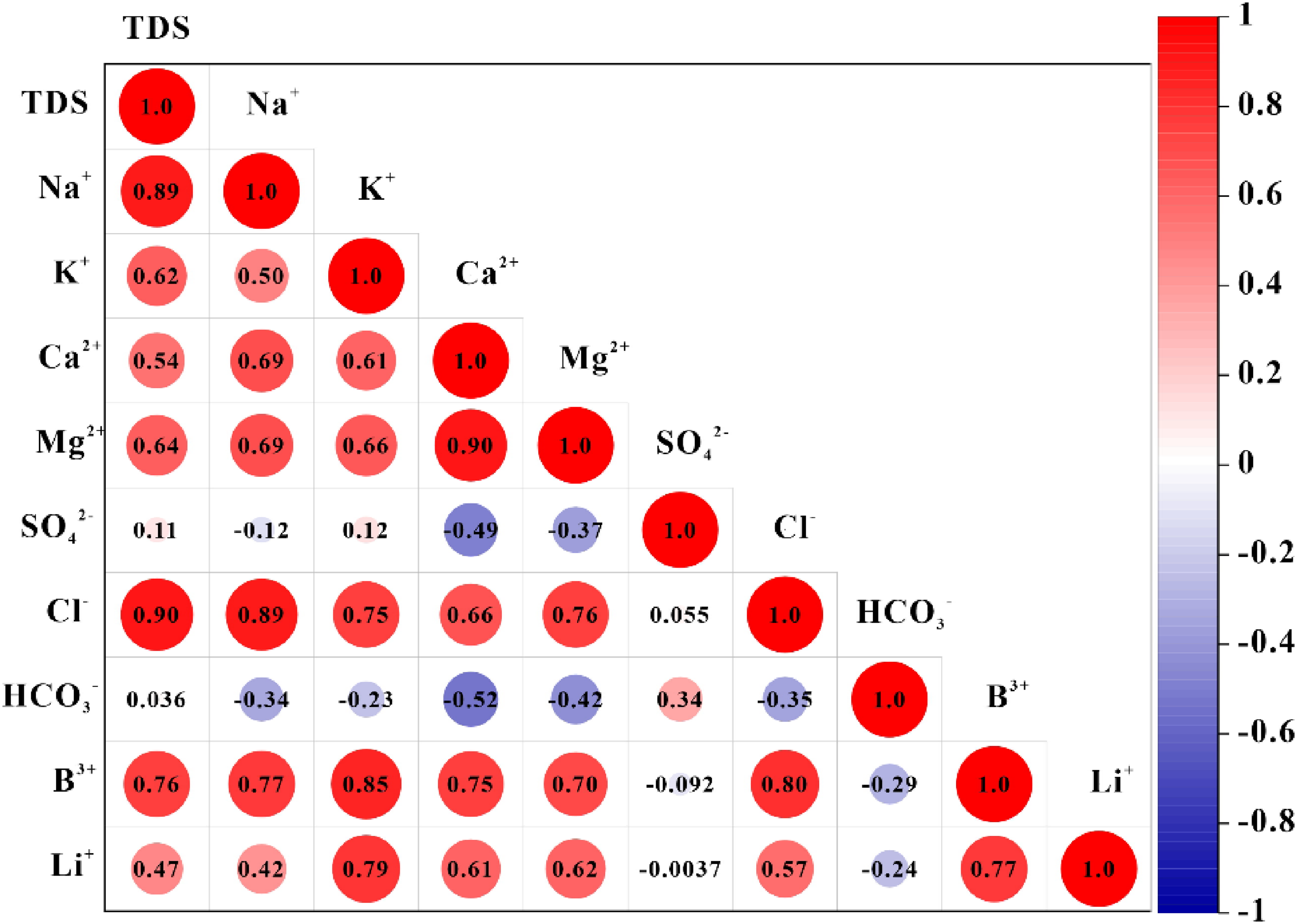
Synthesising the above analyses, two geothermal gradient anomalies in the western and central QB, which are characterised by distinct concentration differences in key elements including K, Li, B, Br and Sr. The Li and B in deep brines from the western-central QB display pronounced spatial heterogeneity. This suggests that, during high-temperature water–rock interactions that leached Li and B from Li–B-bearing clastic rocks within deep brine reservoirs,9,36 the provenance of these clastic rocks may have varied, leading to heterogeneous Li–B enrichment in brines across different parts of the basin. For instance, within the modern salt lake brine system, Li and B sources are predominantly controlled by high-flux B inputs from the Da Qaidam hot springs in the northern basin,6,11,12,39 whereas Li is mainly governed by fluids from the Bukadaban hot spring in the southern basin. 1 This has resulted in the formation of B-enriched salt lakes in the northern basin, dominated by Da Qaidam Lake and Xiao Qaidam Lake, 11 and Li-enriched salt lakes in the southern basin, represented by Yiliping Lake, Dongtaijinair Lake, Xitaijinair Lake and Bieletan subbasin. 1 This suggests that the sources of Li and B in deep brines of the QB are analogous to those in modern salt lakes and may be governed by distinct end-members. This is supported by the ion correlation heatmap, which yields a Li–B correlation coefficient of 0.77 (Figure 5). This also suggests that B and Li in deep brines may derive from B- and Li-rich hot springs formed over geological time. 9 Furthermore, following moderate evaporation and concentration of the deep brines (Figure 3),9,17,18 both elements are enriched to varying degrees, further enhancing their correlation. These observations collectively reinforce the interpretation that Li and B are derived from different end-member sources. This pattern is closely linked to the spatial distribution of Li–B-rich lithologies in the QB2,40 and worldwide.41,42 In the northern basin, near the Da Qaidam hot springs, occur the Dakendaban feldspar-bearing granites (mean B = 33,391.03 ppm) and other ultrahigh-pressure metamorphic belts (mean B = 909.96 ppm),2,10 which are characterised by notably high boron contents. By contrast, the southern basin around the Bukadaban hot spring is dominated by Li-rich pegmatites and volcanic rocks (Li = 96 mg/L). 43 This also accounts for the higher Li relative to B contents in deep brines from the central basin. Southern-derived water systems not only transported dissolved Li but also delivered Li-bearing detritus to lacustrine sediments. In contrast, the B-rich plutons and ultrahigh-pressure metamorphic belts in the northern basin experienced more intense southward weathering relative to peraluminous and volcanic rocks. Moreover, these ultrahigh-pressure metamorphic belts may have acted as a structural barrier, inhibiting southward transport of B-rich detritus into the southern basin (Figure 1(a)).
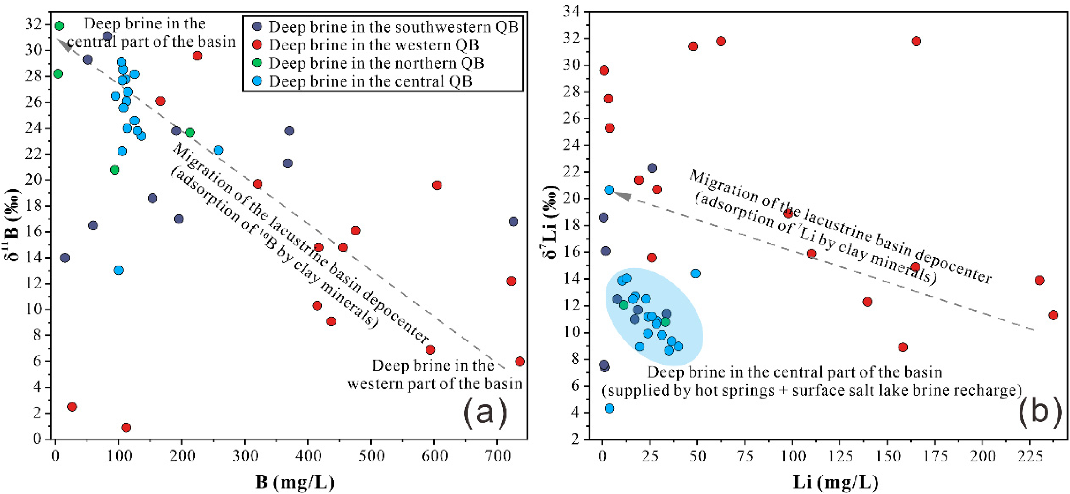
On the other hand, shifts in the locus of sedimentation within the QB lake basin exert a significant control on the enrichment of K, B, Li and other elements in deep-seated brines. 9 Western QB (Nanyishan, Xiaoliangshan, Dafengshan) acted as the main lacustrine depocentre during the Late Eocene–Oligocene.20,24 Its long persistence promoted the formation of K–B–Li-rich deep brines, forming a key initial source for subsequent depocentre migration. During the Miocene and Pliocene, the lacustrine depocentres migrated eastward from western QB to the northern (Lenghu, Eboliang) and central (Yahu, Hongsanhan, Jianshishan) regions. 9 This spatiotemporal shift is clearly manifested in the B–δ11B and Li–δ7Li geochemical signatures of deep brines (Figure 6(a,b)). Specifically, B and Li contents decline from west to central basin, accompanied by progressive increases in δ11B and δ7Li (Figure 6(a) and (b)). These systematic variations likely arise from the preferential removal of 1⁰B and 6Li via adsorption onto clay minerals during long-distance brine migration. Depocentre migration not only exerts a major control on B and Li enrichment in deep brines but also exerts a significant influence on K abundances. During brine migration, clay minerals exhibit a stronger adsorption affinity for K relative to Li and B. 6 Consequently, K concentrations in deep brines from the central basin are markedly lower than those in the western basin.
Variations in Br and Sr contents of deep brines provide effective geochemical tracers for reconstructing sedimentary depocentre migration across the QB. Extensive high-grade celestite (SrSO₄) in western QB supplies abundant Sr to deep brines during weathering,44,45 leading to distinctly higher Sr concentrations in the west than in the centre. This pattern may partly record depocentre migration, which drove the lateral transport of Sr from western to central parts of the basin. High Br abundances in QB brines and adjacent areas mainly originate from water–rock interactions and Br desorption from sediments and organic matter. 46 Significantly higher Br concentrations in western deep brines relative to the central basin may further record the west-to-east migration of the lacustrine depocentre.
In summary, spatial variations in B and Li contents of QB deep brines reflect anomalous reservoir geothermal gradients (Figure 7(a)). Boron and lithium were leached from B–Li-rich detritus, mainly derived from B-rich tourmaline granites, Li-rich pegmatites and volcanic rocks (Figure 7(b)). Lacustrine depocentre migration controlled the spatial heterogeneity of B, Li, K, Br and Sr.
(a) Distribution of geothermal anomaly high-value zones in Qaidam Basin; (b) Distribution map of B- and Li-rich magmatic rocks, ultrahigh-pressure metamorphic rocks and marine rocks in Qaidam Basin (modified from a previous study 2 ).
Conclusions
This study integrates major and trace element concentrations, H–O and Li–B isotopic data of deep brines in the QB, together with newly acquired hydrochemical, H–O and He isotopic results from the Yahu, Hongsanhan and Jianshishan anticlines and in situ temperature records of 55 deep boreholes, to conduct comprehensive geochemical and geothermal analyses. The main conclusions are as follows:
Significant spatial heterogeneity exists in K, Li, B, Br and Sr concentrations of deep brines. Element contents are distinctly higher in the western basin, while only low-grade B and Li resources occur in the northern and southwestern areas. High-temperature water–rock interaction facilitates leaching and release of B and Li from clastic materials. H–O isotopic signatures of western basin brines fall within the deep magmatic fluid domain, accompanied by abnormally high geothermal gradients. Borehole temperature measurement, cation geothermometry and He isotopic evidence reveal anomalous geothermal gradients in the central basin, where fluids are predominantly crust-derived. High-temperature anomalies concentrate along the Nanyishan–Dafengshan and Yahu-Hongsanhan anticlinal belts. Total B and Li contents of deep brines are constrained by B–Li-rich lithology. Modern salt lake material sources also affect brine composition. Sufficient Li supply elevates Li/B ratios in central basin brines. B and Li enrichment shows striking regional disparities, whereas K, Br and Sr distribute relatively evenly. Their compositional variations are primarily governed by lacustrine depocentre migration, which is further verified by west-to-east variations of δ11B and δ7Li in deep brines.
Footnotes
Acknowledgements
We thank Tong Pan and Guang Han for their help with the fieldwork and part of the discussions of this manuscript. This study was supported by the Research on the Genesis Mechanism of Underground Hot Water and Target Area Optimisation in the Da Qaidan Hot Spring Valley-Mangya Area, Qinghai Province.
Author contributions
Liang Lu: data curation, formal analysis, investigation, methodology, writing—original draft. Jie Dang: methodology, project administration, resources, writing—review and editing. Changyin Li: data curation, formal analysis, methodology, resources, writing. Jun Qi: investigation, methodology, resources. Guowei Zhang: data curation, formal analysis, methodology, resources. Kangnan Cheng: discussion, investigation, methodology, data curation, formal analysis, writing—review and editing.
Funding
The authors disclosed receipt of the following financial support for the research, authorship, and/or publication of this article: This work was supported by the Genesis Mechanism of Underground Hot Water and Target Area Optimisation in the Da Qaidan Hot Spring Valley – Mangya Area, Qinghai Province.
Declaration of conflicting interests
The authors declared no potential conflicts of interest with respect to the research, authorship, and/or publication of this article.