






Abstract
Over time, humans have developed the capability to distinguish and capture finer portions of the electromagnetic spectrum at higher resolutions. Modern optical sensors can resolve the Earth in detailed color at resolutions of up to 10 cm. This type of passive remote sensing mimics human vision by recording spectral information, or light. Yet another technique which does not measure spectral information, synthetic aperture radar (SAR), is increasingly used in military, commercial, and scientific applications. SAR satellites shoot microwave pulses of energy, which penetrate clouds and darkness, at the Earth’s surface and measure the returned signal, or backscatter. This electromagnetic data allows consistent interpretation of surface properties, structure, and motion, regardless of the weather or time of day. Although often visualized as an image, SAR data does not lend itself well to orthodox spatial intuition, and its production and interpretation require advanced technical skills. Theorizing the political and epistemic consequences of SAR necessitates transcending visual critiques of remote sensing, which have largely considered optical satellite imagery, because SAR is iconoclastic. The technology upends the preeminence of the divine view of the “blue marble” of Earth and instead values the invisible and electric. Herein, we review SAR and offer a more-than-visual critique of its data to problematize how it makes sense of the world – and the haptic, shadowy world it is setting into motion, where information transparency is disappearing even as more data are captured than ever before. SAR imagery is tricky for laypeople to interpret, which may challenge democratic accountability at a time when the data increasingly informs governance. The rise of SAR also shifts politics upstream from the interpretation of optical images based on a relatively shared visual vocabulary to the production of imagery inferred from electromagnetic signals.
Introduction
A month after Russian tanks invaded Ukraine in February 2022, the country’s then Deputy Prime Minister and Minister of Digital Transformation, Mykhailo Fedorov, posted a letter to Twitter. He beseeched the heads of eight commercial satellite imaging companies: We badly need the opportunity to watch the movement of Russian troops, especially at night when our technologies are blind in fact! SAR satellite data is important to understanding Russian troops and vehicle movements at night considering that clouds cover about 80 percent of Ukraine during the day. (Fedorov, 2022)
Fedorov was requesting synthetic aperture radar (SAR) data, which differs from the photorealistic imagery typically associated with satellites. This picturesque data, called optical imagery, captures the Earth in all its kaleidoscopic glory, from the dazzling blue of the Dalmatian Sea to the vermillion hues of the Namib Desert. Data from optical satellites replicates human vision by sensing wavelengths ranging from roughly 380 nm (blue light) to 780 nm (red light). Such imagery is collected passively, capturing sunlight reflected off the Earth or other ambient light emitted from the planet, like fires and city lights. Over the years, technological advancements have dramatically improved optical imagery’s spatial resolution, or the size of the smallest feature that can be represented, to 10 × 10 cm (Frischauf, 2018; Yazici, 2025). This clarity has spurred the imagery’s dissemination by news outlets and on social media (Lawrence, 2025). It has also motivated critical scholarship focused on the visuality and aesthetics of satellite imagery (DeLoughrey, 2014; Litfin, 1997; Parks, 2001; Shim, 2014; Witjes and Olbrich, 2017), particularly at the global scale.
SAR data provides no such “planetary gaze” (Litfin, 1997), nor does it simulate how the planet would look to an astronaut floating above Earth. Instead of capturing color, SAR maps structure, surface texture, and dielectric properties, notably moisture content. The technology’s origins lie with radio detection and ranging (radar). In 1935, British engineer Robert Watson-Watt demonstrated that microwaves, a type of high-frequency radio wave, bounce off metal objects, enabling their detection and location. This realization caught the attention of militaries, which adopted and advanced radar during the Second World War (Meyer, 2019). Radar and its descendants such as SAR constitute active rather than passive systems. Instead of collecting reflected light like an optical sensor, they emit a microwave signal and measure its return, or backscatter. Terrestrial fixed radar stations, unencumbered by the constraints of orbital mechanics, can use large physical antennas to achieve fine spatial resolution and high sensitivity, enabling “over-the-horizon” detection of objects like incoming missiles.
Representing something of a departure from radar, SAR has offensive rather than defensive applications. At the beginning of the Cold War, the U.S. military sought to develop early moving target detection systems to provide onboard, day/night, all-weather guidance to fighter pilots and cruise missiles. This necessitated live, high-resolution mapping, which theoretically would have required putting a radar several kilometers long into the air – an improbable feat. In 1951, Carl A. Wiley, an engineer at U.S. company Goodyear Aerospace (now part of Lockheed Martin), discovered a workaround. He realized that a small, moving radar antenna could synthesize a much larger one by measuring Doppler shifts, or changes in the phase of the returned signal, relative to its position (Lasswell, 2005). This “synthetic aperture” principle allows SAR to create high-resolution images and maps through motion and computation. In 1954, Wiley filed for the first SAR patent. Ten years later, U.S. Air Force pilots flying Lockheed’s SR-71 “Blackbird,” a reconnaissance aircraft, were using SAR to map the ground 25,000 m below as they whizzed overhead at three times the speed of sound. The world’s largest military contractor claims that SAR “gave the Blackbird ‘eyes’” (Lockheed Martin, 2020), but the technology does not exactly see. Whereas an optical sensor collects the light reflected by objects within its field of view, radar discriminates between surfaces, structure, and moisture content. This generates a more holistic and haptic representation useful to military, scientific, commercial, and civilian users interested in discerning not just the look, but the shape of the world.
SAR was first slotted into orbit for military purposes in 1964 with the U.S. National Reconnaissance Office’s Quill satellite, which experimented with radar imaging of Earth. In 1978, NASA launched the first civilian SAR satellite, Seasat, which mapped sea surface, wave heights, and ocean topography. Throughout the 1990s and 2000s, governments around the world gradually licensed and launched more SAR satellites like the European Space Agency (ESA)’s European Remote-Sensing Satellites (ERS-1 and ERS-2), the Canadian Space Agency’s RADARSAT program, and the Japan Aerospace Exploration Agency’s Advanced Land Observing Satellites (ALOS-1 and ALOS-2). RADARSAT-1 was distinct in that it was manufactured and operated by Canadian and American aerospace companies, setting the stage for the commercialization of SAR in other countries. The United States finally followed suit in 2018, issuing its first commercial SAR license to San Francisco-based Capella Space decades after the federal government issued the first commercial optical license in 1995. Today, besides Capella, high-resolution SAR imagery is acquired by companies including Umbra (United States), MDA Space (Canada), ICEYE (Finland), SI Imaging (South Korea), and Chang Guang Satellite Technology (China). Their imagery holds immense strategic value for militaries and intelligence agencies, which are often the primary contractors. The emergence of the commercial satellite industry combined with computing advances has fueled SAR satellites’ exponential growth. By 2021, over 50 civilian and commercial SAR satellites were operational – more than double the number in 2018 (Rosen, 2021). In 2025, the US$1.5 billion NASA–Indian Space Research Organisation SAR satellite (NISAR) was launched, representing NASA’s first SAR satellite since Seasat (Inggs, 2022). NISAR is also reportedly the most expensive Earth observation satellite in history (Greshko, 2025).
Two major benefits of SAR compared with optical satellites are its ability to sense the Earth regardless of weather or day/night conditions and its sensitivity to structure rather than light. This appeal has been enhanced by ongoing improvements to SAR’s ability to resolve fine details thanks to advances in hardware and signal processing (specifically, backscatter interpretation) and, at least in the United States, loosened government regulations, which have historically restricted the spatial resolution of commercial SAR imagery (Bernstein, 2023; Meng et al., 2024). SAR is also being combined with artificial intelligence (AI) to automatically detect and track targets and trace social and environmental patterns and processes (W. Feng et al., 2024b), expanding the technology’s applications beyond mapping to predictive modeling.
As SAR imagery grows in precision, automation, and popularity, the media has taken notice (Chang, 2025; Piesing, 2024), but scholarship has yet to follow suit. One article in The Economist (2022) headlined, “Synthetic-aperture radar is making the Earth’s surface watchable 24/7,” explained the technology’s capacity to surveil nearly all of the planet’s surface, even on the cloudiest days or during the polar night. The only hiding spots that remain, the article cautioned, are underwater. Yet scholars of satellite imagery in visual culture, media studies, and geography still almost exclusively critique optical imagery. Drawing on visual and image theory, their research largely considers topics like the gaze, aesthetics, and photorealism. Such work has contributed significantly to understandings of the power and politics of optical satellite imagery and its limitations and biases, too (Bennett et al., 2022; Herscher, 2014; Litfin, 1997; Livingston and Robinson, 2003; Perkins and Dodge, 2009; Rothe and Shim, 2018; Shim, 2014). This literature, however, overlooks non-optical satellite imagery. Satellites have largely been regarded as “seeing machines,” and their measurements in the more-than-visible portions of the electromagnetic spectrum left uninterrogated.
Problematizing SAR requires making use of distinct conceptual tools to grapple with its noisy, electrical signals. To develop a framework for understanding both the capacities and limitations of SAR, in what follows, we first offer a primer on the technology. Then, we complicate critiques of optical satellite imagery. Drawing on insights from the philosophy of imagery rather than strictly the philosophy of photography, we argue that although SAR claims to present an uninterrupted view of the planet immune to cloud conditions or the time of day, such omniscience comes at the cost of its imagery’s affective power, or ability to provoke emotions. SAR, we argue, is iconoclastic because it displaces the lofty gaze of a blue–green Earth with electrical signals that can only be visualized through inference.
Herein lies the danger. Precisely because the public is not easily able to intuit such non-visual “technical imagery,” to use a concept from Brazilian–Czech philosopher Vilém Flusser (2011), the data is more likely to stay within the realm of highly trained specialists. With the rise of SAR, political struggles shift from interpreting optical photographs using a relatively shared visual vocabulary upstream to the production of opaque imagery inferred from complex signal processing and physical models. As environmental data, including remotely sensed data such as that collected by satellites, increasingly informs governance (Gabrys, 2016; Gabrys et al., 2025; van der Velden et al., 2025), the public may find itself ill-equipped to interrogate data-driven decisions. This problem resembles the challenges posed by society’s reliance on “black box” technologies like AI (von Eschenbach, 2021) and location tracking (Cooke et al., 2025). The specific danger within Earth observation is that optical images will likely retain their affective power over the public. SAR data, however, may increasingly undergird political power, or the ability to make decisions and even to define the structure of reality. Backscatter’s relative lack of affect means that the public may turn a blind eye to it even as the data grows in actionability and hegemony.
Sensing like a SAR satellite
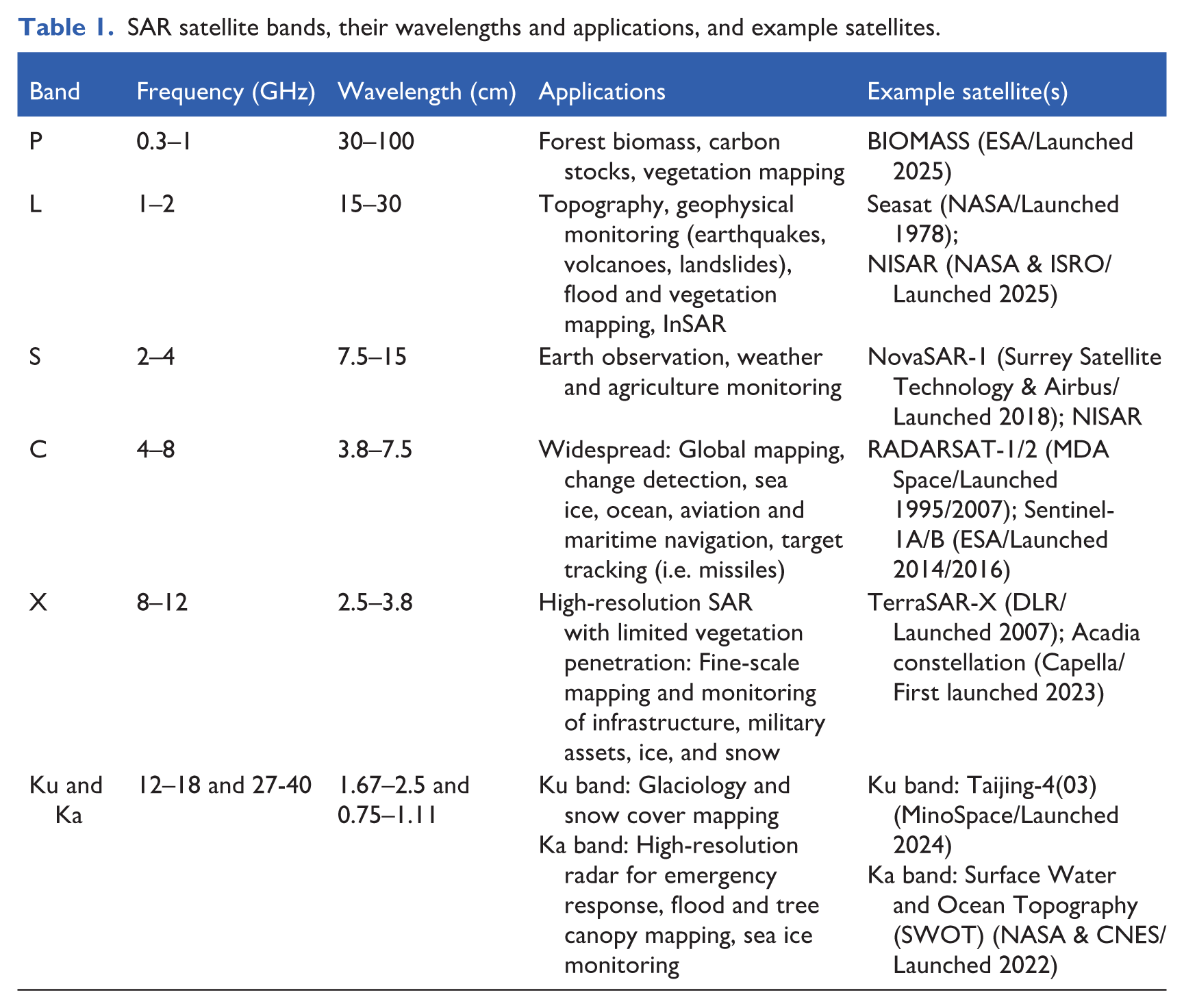
In many ways, SAR mimics listening rather than seeing. The technique resembles echolocation by emitting frequency-modulated pulses of energy called “chirps,” which bounce off the target, providing insights into its geometric properties like distance from the viewer, height, and surface roughness, and dielectric properties like moisture content. A SAR sensor is engineered to use a specific microwave portion of the spectrum ranging primarily from the P- to X-bands (and, infrequently, the Ku and Ka-bands) (Table 1). SAR wavelengths respond to physical structure and dielectric properties rather than the fine-scaled pigments passively detected by optical sensors. Longer wavelengths like the P- and L-bands penetrate forest canopies and soil, while shorter wavelengths like the X-band are more sensitive to surface roughness. A SAR sensor can transmit and receive signals using either horizontal (H) or vertical (V) polarization, which controls the orientation of the wave’s oscillation. Various surface properties are revealed by different transmit–receive combinations, namely HH and VV, which are co-polarized, meaning the sensor receives the return signal in the same polarization state, and HV and VH, which are cross-polarized.
SAR satellite bands, their wavelengths and applications, and example satellites.
Another difference from optical satellites, which typically look straight down at Earth, is that SAR satellites sense the planet obliquely. This “side-looking” geometry, which orients the sensor 20°–60° (the “incidence angle”) away from the satellite’s direct downward path, or nadir, is fundamental to SAR imaging. As the satellite orbits Earth, the sensor transmits microwave pulses to its surface. The returned signal, or backscatter, contains two critical pieces of information: the amplitude (the strength of the returned signal) and phase (the location of the signal within the wave cycle). The amplitude reveals surface and material properties, while the phase enables the calculation of precise distances through interferometry (InSAR). When observations are repeated using a process known as repeat-pass interferometry, SAR can track millimeter-level surface deformation over time. All SAR “images” thus emerge through intensive computational processing that transforms amplitude and phase measurements into spatial patterns.
The relationship between SAR measurements and actual surface properties defies intuition. For example, a large ocean swell that appears dramatic to the naked eye may appear deceptively featureless in an X-band SAR image. That is because its 2.5–3.75 cm wavelengths interact not with the larger ocean waves, but with the shorter, capillary waves whose spacing is comparable to the radar wavelength. One of the most important surface properties dictating returned backscatter is thus surface “roughness” in relation to the wavelength used. Broadly speaking, smooth surfaces like calm water reflect the radar pulse away from the sensor (“specular reflection,” producing low backscatter), and rough surfaces scatter energy diffusely in all directions (Figure 1). Beyond these, vegetation and tree canopies produce “volume scattering” as the signal bounces among the leaves, branches, and stems, depolarizing it and yielding relatively strong cross-polarized (HV/VH) returns. Human-made structures standing perpendicular to the ground result in high backscatter due to “double-bounce scattering,” particularly in co-polarized (HH/VV) channels. In SAR visualizations, higher backscatter tends to be illustrated by brighter pixels, while weaker backscatter is illustrated by darker pixels. Pixel brightness also depends on the amount and wavelength of energy originally transmitted by the SAR antenna and the angle at which the object is sensed. This makes the technique arguably more relational than optical remote sensing, whose passive imaging techniques borrow from photography, or “light writing” (Zawojski, 2021). SAR visualizations can also be enhanced by combining different polarization measurements from the same dataset to help distinguish between features such as water, urban areas, vegetation, and bare ground. The resulting visualizations can be compared with optical imagery taken over San Francisco on a summer day, when fog obscures nearly half the city (Figure 2).
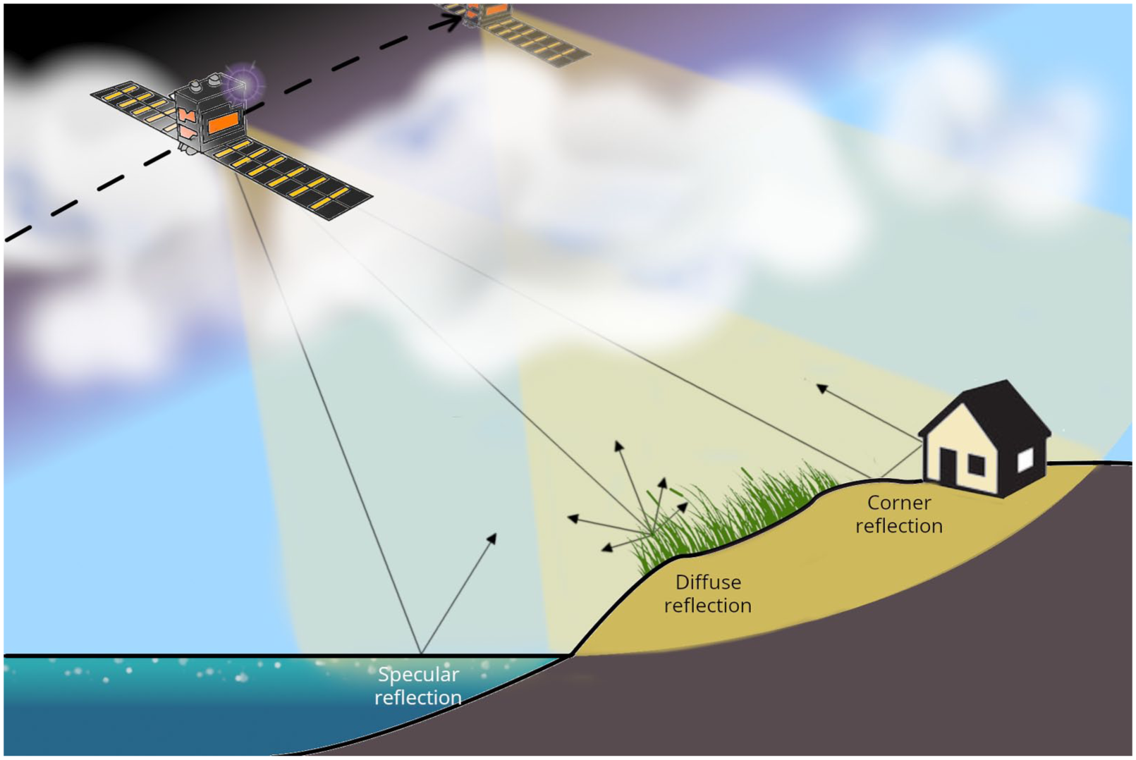
The microwave energy emitted by a SAR satellite interacts differently with various surfaces on Earth, generating a range of backscatter effects.
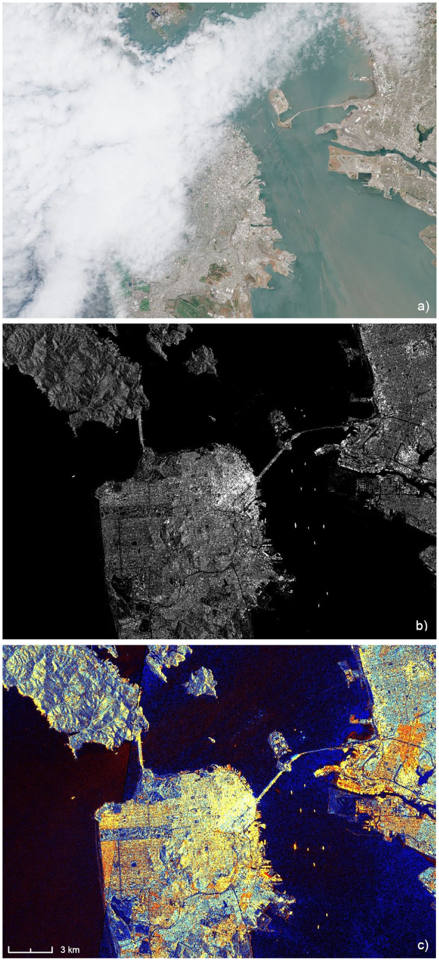
San Francisco, Calif., USA on July 12, 2025 as captured by the ESA’s Sentinel-1 and -2 satellite missions. (a) Real-color visualization of Sentinel-2 optical imagery. (b) Sentinel-1 SAR backscatter (VV polarization). The brightest pixels arise from double-bounce scattering, where building walls and the ground form corner reflectors that redirect the radar pulse back to the sensor. Intermediate backscatter arises from diffuse scattering off rough surfaces and volume scattering within vegetation. The darkest areas are calm water surfaces, which reflect the signal away from the sensor (specular reflection). (c) False-color composite displaying VV polarization as red, VH as green, and the VH/VV ratio as blue. Urban areas appear yellow because strong co-polarized (VV) double-bounce returns combine with moderate cross-polarized (VH) returns. Vegetation appears turquoise because volume scattering within plant canopies depolarizes the signal, elevating VH and the VH/VV ratio. Bare ground and water appear dark because both channels return little energy. The density of buildings in downtown San Francisco (the bright yellow and white cluster of pixels in the city’s northeast corner) is apparent. Underlying visualizations are sourced from Copernicus Browser (https://browser.dataspace.copernicus.eu/).
The fact that SAR visualizations do not represent light produces an interpretative trap. They invite viewers to project their semiotic expectations of a photograph onto electromagnetic measurements that operate according to entirely different principles. A SAR satellite imagery tutorial offered by Esri, the world’s leading geospatial software provider, explains, “The way the landscape is represented may seem unusual, since it was captured by a SAR sensor and not an optical camera: it doesn’t look like a photo” (Menezes, 2025). SAR imagery is typified by grainy, black-and-white or false-color pictures. Even high-resolution SAR images such as those disseminated by companies like Capella or Umbra look spooky. Buildings appear reduced to their steel skeleton frames. Grass and topsoil disappear from meadows, exposing ancient paths hidden below.
Typically, a photographer takes images by silently snapping their camera without interacting with the observed object. As an art form, Wilder (2009) ventures, photography has “paid a steep price for its association with the socially powerful cult of observation – it was linked with the passivity that was required of successful observation” (p. 164). Photography, of course, is hardly a passive practice: it is an art whose ability to render reality is influenced by not only the skill and dexterity of the photographer, but by the subjects captured, too (Benjamin, 1972 [1931]). Light can also be considered as an “agent of immersion” that “exposes the porosity of bodies and selves” (Lantto Klein, 2025: 245). Feminist thinking around light views it as a “perceptual field between subjects” (Hawkins, 2015: 175), with color embodying its exchange between living beings (Sullivan, 2014). By suffusing light with agency and embodiment, such perspectives problematize the active/passive binary within remote sensing. Still, light can never “[announce] its own presence”: as humans, we can only infer its existence when it bounces off surfaces and the atmosphere (Miles, 2005: 334). Yet there is no doubt that light, both literally and in the Baradian sense (Barad, 2003), matters. For plants, whose photoreceptors can distinguish between the quality, intensity, direction, and duration of light (Galvão and Fankhauser, 2015), light is a matter of life and death – one they (and the photosynthetic sea slug E. chlorotica (Rumpho et al., 2008)) convert into energy. What humans see, plants eat. Then, further complicating the plant–animal and touch–sight divides, there are cup corals, which feed on zooplankton. Eva Hayward (2010: 582) introduces the concept of “fingeryeyes” to conjure the sensorium of the tubular orange organism: “seeing with tact; touching by eye; feeling from vision.” Even for humans, the senses may not be so distinct: scientists managed to convert visual stimuli captured by a camera into “electro-tactile pulses” sent to the tongues of blind people, whose “tactile-‘visual’ acuity” they then measured (Chebat et al., 2007: 1901). Paralleling this convergence of sensory organs, heat, or the transfer of energy between objects, can be visualized in ways that merge cooler and warmer objects, such as a hand grasping a hot kettle. Within this Deleuzian framework melding life, matter, and agency, “thermal sensations” become ‘beings’ in themselves” (McHugh and Kitson, 2018: 173).
Whichever theoretical frameworks one applies, SAR’s interaction with its target endows it with an indisputably relational epistemology. Whereas a person can be unwittingly photographed, SAR cannot image its target without announcing itself, for its microwave pulses can be detected with appropriate equipment. This detectability has direct strategic consequences. While optical satellites motivate hiding and camouflage, deceiving SAR satellites demands electronic interference and jamming, which cause the sensor to detect inaccurate range and azimuth measurements (Dai et al., 2007, see also Solomon, 2013). These tactics are being widely employed in the wars in Ukraine and Iran. Figure 3 shows radar interference with ESA’s Sentinel-1 satellite, which obscures the ships in the harbor. With radar’s cover increasingly blown, since the late 2010s, advances in signal processing have revived interest in covert techniques like passive radar, an innovation dating to the Second World War, which emits nothing and instead detects targets by intercepting the reflections of existing broadcast, communications, and navigation signals off of objects (Griffiths and Baker, 2022). The radar arms race is transforming the electromagnetic spectrum into a battlefield. What is politically at stake is not just which targets can be identified, but control of the electromagnetic environment itself via the transmission, interception, jamming, or silencing of signals. Moreover, as reality is increasingly experienced through and mediated by screens, controlling electromagnetic signals becomes key to knowledge and power. If a ship’s captain depends on radar to tell them where they are and those signals get jammed, their sense of reality and ability to navigate in the world risk breaking down.
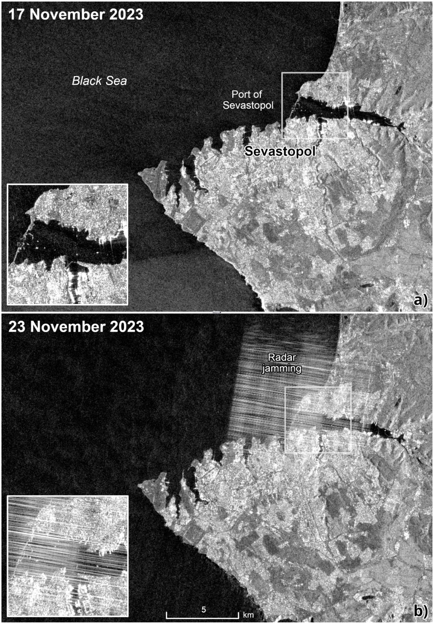
Sentinel-1 SAR imagery over Sevastopol, the largest city in Crimea. The image from 17 November 2023 (a) is clear, while the image from 23 November 2023 (b) exhibits radar interference. This prohibits clear detection of ships and port infrastructure, as illustrated by the inset map. The underlying visualizations, which were obtained from Copernicus Browser (https://browser.dataspace.copernicus.eu/), use the decibel γ0 of the VV polarization, which is sensitive to surface roughness.
Optical satellite imagery and the myopia of visual critique
Critiques of satellite imagery, which emerged in the 1990s, almost exclusively concern optical satellite imagery, though the term “optical” term is often omitted. Although Donna Haraway (1988: 581) does not explicitly mention satellites in her unveiling of the “god trick of seeing everything from nowhere” – science’s assertion of omniscience and objectivity by virtue of its distanciated view from above – others have built on her work to critique the technology from a visual standpoint. Emphasizing color and light, political scientist Karen Litfin (1997: 39), contends, “The planetary gaze, relying on cameras collecting data at various wavelengths to inform us about the earth through color-coded computer simulations, is fundamentally a visual project.” Literary scholar Elizabeth DeLoughrey’s (2014) article on “satellite planetarity” opens with the spectacle of a U.S. space shuttle flying low over Los Angeles in 2012. This bombast, she offers, reminds that “vessels and visuality are vital to imagining and territorializing outer space” (p. 258). In her analysis, the power to see and depict are prerequisites for projecting power above Earth – and on it, too.
While critiques of remote sensing have begun to problematize remoteness and what distance from the field can alternately open up and close off (Kroth, 2025), sensing still tends to be conflated with seeing. International relations theorist David Shim (2014: 152) defines “remote sensing – or what can also be called ‘remote seeing’” as “literally meaning the acquisition of information about an object, place or phenomenon on the Earth’s surface by means of distant observation”. Media theorist Lisa Parks (2001: 589) argues, “The satellite image functions not only as the state’s official perspective, but can also be used to implicate the state of whatever lies in the field of vision.” Yet as we show with SAR, remote sensing transcends seeing.
Satellite imagery has also primarily been perceived as scaling up the optical power of those who control the technology rather than extending it into other domains. Geographer Dennis Cosgrove (2001: 3) echoes Litfin’s contention when he expresses, “. . .until 1968 ‘seeing’ the spherical earth meant imagining or picturing it, an activity often inseparable from visionary experience”. In Western spatial sensibilities, vision has generally been the preeminent sense since the ancient Greeks (Jay, 1993). Yet there are other, non-Western ways of imagining the world as a sphere borne out of tactile experience rather than pictures made by the mind’s eye. The Polynesians, with their ocean-spanning navigational capacities, may have realized that the world was round. They also may have communicated navigational knowledge by synthesizing “cognitive information (e.g. star relationships) with visual, auditory, and kinesthetic information about the waves and wind into an integrated whole” (Feinberg and Genz, 2012: 337), making planetary ideation multisensory. Despite these more-than-visual planetary renderings, Cosgrove (2001: 15) underscores, “To imagine the earth as a globe is essentially a visual act, as the Apollonian gaze implies.” Both words within the term “Apollonian gaze” allude to the visual: Apollo is the Greek god of the sun and light, while gaze means an intense, steady look. 1 The Apollonian gaze, Cosgrove (2001: xi) explains, produces a “divine and mastering view from a single perspective.” Yet the globe is actually “an object with a rounded form and fields out of sight, rather than a map with full oversight” (Skaanes, 2021: 254). From this perspective, the “full-disc” view of planet Earth first provided by the U.S. Department of Defense’s DODGE satellite in 1967 does not offer omniscience. Closer vantages showing only a small swath of Earth, like those provided by SAR satellites in low Earth orbit, can provide a great amount of information, or “actionable intelligence,” to use the jargon of defense contractors, which can affect geopolitics. This is particularly true when constellations of satellites covering all of Earth capture high-resolution imagery.
The above literature indicates that scopic regimes – dominant ways of seeing and visually ordering the world (Jay, 1988; Metz, 1982) – may ironically be constraining critiques of remote sensing. It is worth dislodging their grip, for a focus on the visual and the global or planetary gaze, however alluring, is myopic and ignores advances in “more-than-optical” remote sensing (Jablonowski, 2020). SAR imagery can prove more actionable than optical photographs because it provides information invisible to the naked eye about structure, geometry, and electrical properties – in other words, the shape and form of the material and physical world, which relates to use and capacity – rather than more superficial information about color and light. SAR imagery can also only be produced through complex calculations and inference, which employ opaque, and, in the case of commercial firms, often proprietary algorithms. This process generates ready-made analytics and statistics, or “satellite imagery as a service,” as opposed to just raw pixels or pretty pictures. Yet these visualizations only convey a fraction of the totality of SAR data, and unintuitively at that. Consequently, much is lost on the uninformed viewer while much is gained by its trained manipulator. Although the persuasiveness of satellite imagery, at least discursively, comes from its visualizations, its actionability comes from data.
The dearth of critique of non-optical satellite imagery is notable given that visual culture scholars have considered non-optical visual media such as X-ray photography (Henderson, 1988; Pamboukian, 2001). The accidental discovery of X-rays in 1895 by German physicist Wilhelm Röntgen sparked a craze for capturing the “nonperceptible”: some hidden fourth dimension, or “supersensible reality” (Henderson, 1988: 33). In the early 20th century, entrepreneurs thought X-rays’ tissue-piercing abilities might offer “the spectacular future of visual entertainment” (Slevin, 2023: 4). The medical sector remains a leading developer of non-visual imaging technologies including ultrasounds, which use sound waves, and magnetic resonance imaging (MRI), which uses magnets and radio waves. As one medical textbook offers, “We do not deal with images in a common sense since most of our imaging machines acquire their data outside the visual spectrum” (Birkfellner, 2014: xxxi). It is worth noting that the word “image,” though it has come to be synonymous with “picture,” derives from the Latin imāgō for “copy” or “likeness” – neither of which need be visual.
Artists, too, have widely experimented with non-visual imagery. A special issue published in 2024 of Leonardo, a leading journal for artists who employ science and technology in their practice, explores the history and future of image processing in visual and non-visual formats. Tali Hinkis, a member of the art duo LoVid, explained, “There is that idea of transformation for me, almost stripping away that original photographic image, and the image processing becomes image creation” (Zinman et al., 2024: 689). SAR takes this process to an extreme because there is never a photograph to begin with: instead, the process almost works in reverse, with electrical data computed and transformed into light that humans can visually interpret.
Scholars have also critiqued ultraviolet and infrared photography, which can mimic the extended range of vision of creatures like birds and bees (Aregger, 2016; Davies, 2017). Telescopes, too, see in these portions of the spectrum, allowing them to peer deep into the cosmos. Humanistic inquiries into the imagery captured by the Hubble and James Webb telescopes reflect a wider fascination with space and astronaut photography (Kessler, 2012, 2021; Leibowitz, 2017). Kessler (2012: 70) argues that in some respects, “the telescope becomes a device not for seeing but for magnifying measurable quantities of light”. Kessler’s consideration of the consequences of the telescope’s perception and measurement of more-than-optical wavelengths, however, has not been adequately applied to Earth observation even though satellites have captured non-visual data since the beginning of the Space Age. The U.S. Air Force’s Vela satellite program, for example, comprised a dozen satellites launched between 1963 and 1970 to monitor nuclear test compliance by surveilling Earth for X-rays, gamma rays, and neutrons (Singer, 2005). Another non-optical satellite was the Soviet Union’s Kosmos-243 (Gorbunov and Kutuza, 2018), which was the first to measure microwave emissions from the Earth’s atmosphere and surface. Ultimately, satellites do far more than see, as SAR, X-ray, gamma ray, microwave, and lidar (light detection and ranging) satellites demonstrate. Critiques of remote sensing must grapple with these more-than-optical techniques to understand the sense-making and world-making capacities of satellites to the fullest – and their politics, too.
Satellite iconoclasm: Trading affect for actionability
Flusser argues that in modern society, visuality structures reality. He traces the evolution of human communication and abstraction of knowledge starting with traditional images like the Lascaux cave paintings, in which people directly drew or painted what they witnessed. Next came linear text, which explained observations literally while giving rise to the human experience of linear time. As these texts have grown more obtuse, they have been broken down into calculable bits and particles. Now, “photos, movies, videos and computers,” Flusser (2011) writes, “have assumed the main role of managing that which had once been managed by linear text” (p. 11). These media and objects, which are increasingly digital, are several steps more removed from reality than a painting. Humans, with their “visualizing power,” compute these bits into images to “make the world tangible, conceivable, comprehensible again, and to make consciousness aware of itself once more. That is to say, the whirring particles around us and in us must be gathered onto surfaces; they must be envisioned” (Flusser 2011: 31). This is the computational process of producing “technical images” (Flusser 2011: 7).
SAR imagery, with all its backscatter, noise, and speckle, exemplifies the technical image. Its proliferation, however, suggests that contrary to Flusser, visuality is no longer the arbiter of reality: instead, that role has shifted to inference. Where an optical satellite image passively captures reflected light at a single point in time, SAR senses according to a fundamentally different geometry. Its sharp single images only emerge after a temporal synthesis of thousands of individual side-looking radar pulses transmitted as the satellite travels along its orbit, making motion rather than stillness the foundation of the data’s clarity. SAR also emits microwaves and carries out countless calculations, transforming electromagnetic phase and amplitude measurements into recognizable spatial patterns. A SAR “image” therefore only exists after a series of algorithmic processes, including range compression to resolve distance, azimuth compression to build along-track resolution, and radiometric calibration to convert raw backscatter into meaningful brightness values. The resulting visualization bears little relationship to human vision: instead, it is calculation made visible.
The images created from SAR data, with their close-up views of buildings seemingly reduced to skeletal metal frames and of undergrowth otherwise hidden by leafy canopies, will likely not become iconic. Noisy SAR visualizations are not gracing magazines as the first full-disk color image of Earth taken by the U.S. satellite DODGE did in July 1967, when it featured on the cover of LIFE magazine (Bryant, 1995). The publication called the pioneering picture the “first color portrait of an angry Earth,” equating the satellite image to a work of art while anthropomorphizing the planet. Despite its lack of iconicity, SAR imagery risks idolization. It is valued if not quite venerated for its supposed ability to represent visible and invisible features in all their physical detail and multidimensionality. Whereas the word “icon” is related to the Greek eikon, for “likeness” or “image,” the word “idol” is from eidolon, for “phantom,” “specter,” or “form” – all terms that recall the eerie visualizations of SAR data.
SAR satellites are iconoclasts, or breakers of images. They do not freeze and imprint light onto a flat surface in the way that film or digital photography does. Instead, they capture the motion of microwave beams bouncing off objects and merge the data into a single visual frame. The resulting visualization resembles a grainy photograph, but its production differs starkly. For SAR imagery, motion and perspectives from multiple angles are required to produce clarity, whereas in optical photography, motion results in blurriness. The ghostly SAR imagery derived from data pertaining to an object’s geometric and electric properties echoes the “less ocular-centric and more haptic scopic regime” (Jay, 2008: 2) found in 15th- and 16th-century Dutch art. The manic paintings of artists such as Bruegel, Vermeer, and Bosch, along with Age of Discovery cartography, brought throngs of individuals and domestic, interior scenes into sharp and detailed relief (Alpers, 1983).
If the spaceborne still-lifes of Earth were icons of the Space Age, SAR images are the idols of New Space, the period in which entrepreneurs rather than national governments are driving the space economy (Peeters, 2021). Whereas icons are likenesses that bear relationships to a prototype – in the case of satellite imagery, Earth – idols are believed to be the thing represented. SAR has not quite become reality, but it purportedly enables those who can interpret its signals to divine – and shape – reality. Finnish company ICEYE (2025), which operates the world’s largest SAR constellation, contends, “ICEYE delivers unparalleled persistent monitoring capabilities to detect and respond to changes in any location on Earth, faster and more accurately than ever before. . .Welcome to a completely new way to understand life on Earth.” The ability to not just see, but act, is key.
While optical imagery captures color and light, SAR exposes structure, texture, and invisible geometries. As such, SAR technicians focus on improving the data’s mathematical rather than visual aspects. To use SAR data quantitatively (in models) and not just qualitatively (as pictures), SAR technicians must ensure a high degree of radiometric calibration and stability. Overcoming radiometric and geometric distortions to the data, which lead to inaccurate backscatter measurements, outweighs eliminating visual distortions. Only then can the characteristics of the sensed objects, such as moisture content or surface roughness, be accurately gauged. As ESA scientist Elise Colin (2025) writes, “Any error in calibration or amplitude measurements can introduce significant biases, jeopardizing the reliability of the results — no matter how beautiful the image may appear”. The value of SAR lies in its haptic rather than visual verisimilitude – in other words, its ability to manifest rather than mirror the Earth.
SAR can also model changes to structure over time when multiple SAR images are combined through InSAR. By measuring phase changes between image acquisition, InSAR can detect just a few millimeters of ground movement, thereby revealing minute surface deformation, whether from human footprints and vehicle tracks (Wang et al., 2021), urban subsidence (Stramondo et al., 2008), or earthquakes and even their precursors (Moro et al., 2017). In contrast, in its most fundamental application, photography attempts to freeze time. As French philosopher Roland Barthes (1981: 85) writes, with photography, “the past is as certain as the present,” and, as an “evidential force. . .its testimony bears not on the object but on time” (Barthes, 1981: 88–89). Soon after the invention of photography in the 1820s, scientists sought to tease out form from two-dimensional captures. By the 1860s and 1870s, scientists in France and Germany invented photogrammetry, combining overlapping photographs to produce three-dimensional models and maps (Polidori, 2021). These 19th-century techniques evolved in the 1970s into computerized processes such as Structure-from-Motion photogrammetry, which calculates the correspondence between multiple photographs to produce three-dimensional point clouds with applications ranging from topographic surveying to geomorphology (Westoby et al., 2012). Yet ultimately, these are derivations of photography, whose essence is to capture light reflected at a single moment. While photography stops time, SAR exploits temporal difference to reveal physical processes invisible to optical imagery.
The spectral appearance of SAR imagery may recall an infamous black-and-white photograph from Hiroshima. Following the U.S. nuclear bombing of the Japanese city in 1945, photojournalist Yoshito Matsushige allegedly captured the shadow of a person vaporized by the bomb (Kim, 2025). The person’s body blocked the intense heat that bleached the stone steps on which they stood, leaving a dark imprint. Widely circulated, the so-called “shadowgraph,” also known as the “Human Shadow Etched in Stone,” provoked public outcry (Schwab, 2023). For once, it seemed someone had photographed a ghost – an irradiated one, no less. But whereas their body fatally prevented the thermal radiation from reaching the stone, leaving a contrast that an optical camera could capture, SAR’s microwaves often register no trace of individual bodies, which fall below most sensors’ spatial resolution or reflect too weakly to appear as distinct forms. No souls, living or dead, appear in SAR imagery. Devoid of beings, its visualizations expose a microwaved world stripped of spirits. The inability of lifeless SAR imagery to stir emotion may paradoxically enhance its power if it leads the public to overlook the data’s world-disclosing and potentially world-making capacities. While SAR imagery may not appeal to broader aesthetic sensibilities, those who can interpret it can perceive not only steel skeletons, but patterns of life – and death, too.
Nevertheless, when destruction is sufficiently catastrophic, even SAR imagery can provoke emotion. One of the most harrowing applications of SAR has been to map destroyed buildings in Gaza using Sentinel-1 C-band imagery (Asi et al., 2024). Microwave signals reflect differently off collapsed walls and roofs than intact ones. In a simple time series of SAR imagery (Figure 4), the backscatter of devastation is clear even to non-specialists.
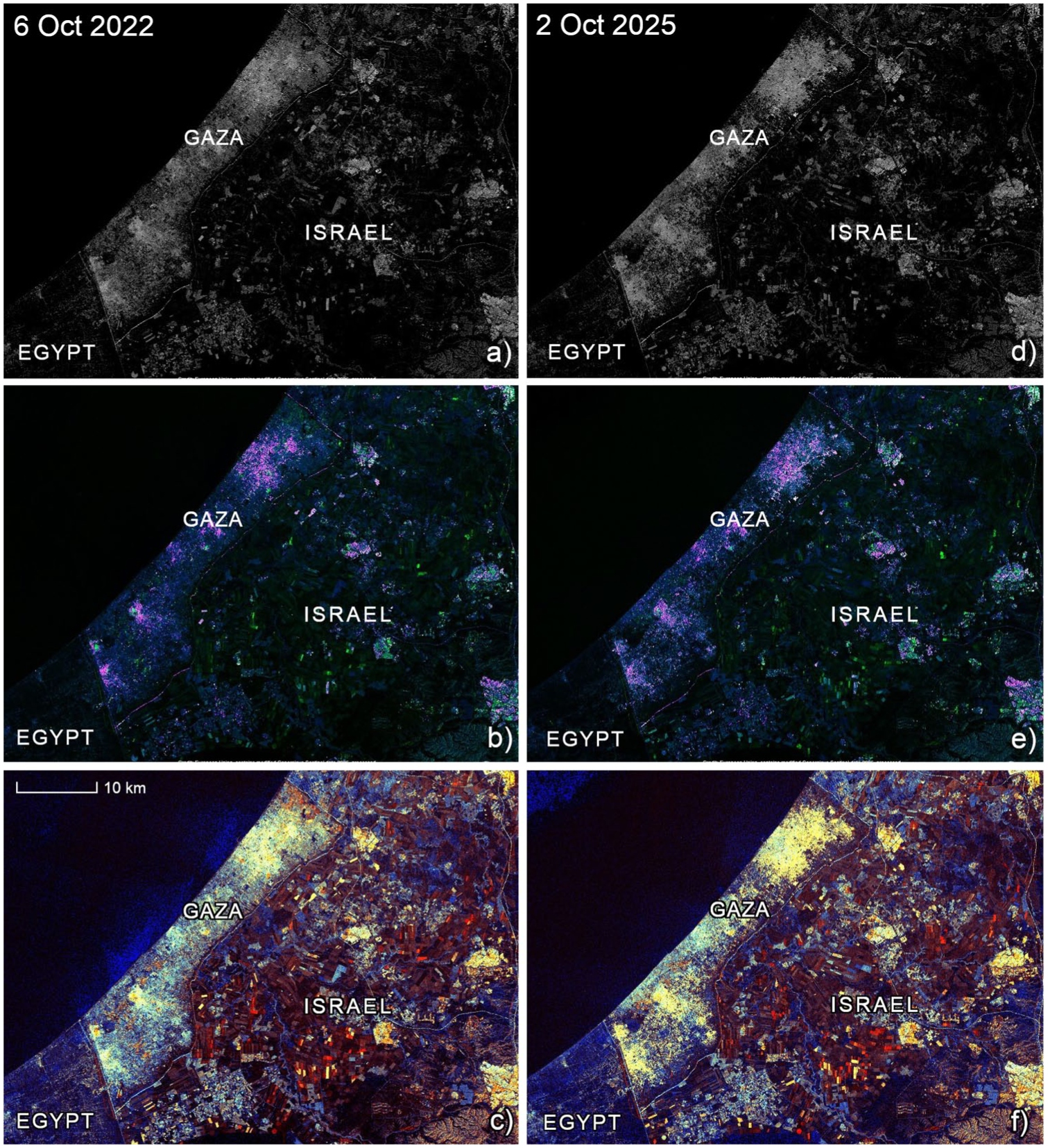
Comparison of Sentinel-1 SAR imagery from before (L) and after (R) the start of the Gaza war. (a and d) Sentinel-1 backscatter (VV polarization). Intact buildings appear as bright pixels as a result of double-bounce scattering, but this geometric scattering is greatly reduced when buildings are destroyed since the resulting rubble scatters energy diffusely. The 2025 image accordingly shows far fewer bright pixels in Gaza than in 2022. (b and e) VH and VV polarizations are combined to highlight built structures, characterized by purple and green. There is a noticeable reduction in buildings and an expansion of bare ground in 2025 compared with 2022. (c and f) False-color composite displaying VV polarization as red, VH as green, and the VH/VV ratio as blue such that urban areas appear yellow, vegetation appears turquoise, and bare ground and water appear dark. The expansion of bare ground in 2025 relative to 2022 is apparent, especially in northwest Gaza, where the loss of double-bounce returns registers the destruction of standing structures. Underlying visualizations are sourced from Copernicus Browser.
Barriers to public literacy of SAR data
When it comes to photographs, until lately, seeing has been believing. As photography became more widespread throughout the 20th century, people gained the capacity to intuit reality from captured light. Imagining three dimensions from two is neither a universal nor innate skill: Aboriginal Australians were alleged to have trouble understanding that photographed animals, whose bodies were only partially visible, were not mutilated but rather shown perspectivally (Slevin, 2023). Today, generative adversarial networks (GANs), a machine learning model that can spit out synthetic images indistinguishable from photographs (Pan, 2021), are testing the association of photography with truthfulness. GANs create imagery so convincing that even computers sometimes cannot tell it is simulated. This technological advance is prompting the public to become more skeptical of optical photography, much to the detriment of photographic authority. Yet a basic understanding – let alone a critical one – of SAR data remains lacking.
With SAR imagery, a great amount of data can only be interpreted by a specialist. In the 1960s, that person took the form of the “radar photo-interpreter,” who as one introductory guide described, “because of his special training and experience, is able to make from radar data meaningful interpretations of photographed areas” (Lester, 1963: 4). Early SAR data was processed optically, with aerial instruments using a combination of lens and lasers to write electrical signals to film, turning backscatter into brightness. In the 1970s, as advances in mini-computing accelerated, MacDonald, Dettwiler and Associates (now MDA Space) invented a digital processor that would be used onboard the first civilian SAR satellite, NASA’s Seasat, in 1978. In the years that followed, the Canadian aerospace company developed three key digital processing algorithms still in use today (Range/Doppler, Chirp Scaling, and SPECAN), which phased out optical processing (Michelson, 2015). Digital processing allowed greater and more precise collection of electrical data, prompting more complex analysis. Visual analysts of early SAR imagery looked for shapes. Contemporary SAR imagery requires knowledge of mathematics and electrical signals, including concepts like radar cross section, dielectric constants, polarization, and coherence, from which factors such as surface roughness, moisture content, and motion can be calculated. Such expertise typically requires training in engineering and geophysics. In 1986, as the U.S. military was more widely adopting SAR, a report by the U.S. Army Engineer Topographic Laboratories (1986: 7) stressed that analysis of radar images required time-intensive, difficult training in “dielectric properties of surface materials including vegetation and manmade objects.” Further illustrating the interpretive challenges, a 1988 U.S. government guide to extracting linear features from radar imagery explained, “If scattering centers are separated by more than the system resolution, the image of the cultural feature takes on a blob-like appearance with blobs of known shape (the impulse response) but unknown location, phase, and height (radar cross section)” (Conner et al., 1988: 3–2).
SAR imagery is also replete with artifacts and anomalies that do not appear in optical imagery. Since radar images involve cylindrical projections of three-dimensional features onto a two-dimensional image plane, distortions are common (Van Zyl and Kim, 2011). One is foreshortening, in which SAR’s slant-range geometry compresses slopes facing the sensor, making them appear shorter than reality. Taken to the extreme, this results in the layover effect, when a topographical feature like a mountain is steep enough that the radar pulse reaches its top before its base, producing an inverted topsy-turvy world to the untrained eye. Even in the absence of such artifacts, SAR imagery lacks intuitiveness. Consider, for example, the rendering of “Colorized VV,” or “Vertical-Vertical,” imagery, on Esri’s Sentinel-1 Explorer website (https://livingatlas.arcgis.com/sentinel1explorer), which is meant to be user-friendly. Using what is probably as plain language as possible, the caption describes: “VV refers to a signal sent in a vertical orientation and returned in a vertical orientation. VV signals are strongest when they reflect off and return from vertically oriented surface features and are good for characterizing soil and water surfaces.” Describing the legend, the caption continues: “Black to amber indicates low backscatter, yellow to white indicates high backscatter.” The image stares the viewer in the face, but technical writing is necessary to communicate its contents. Even then, most viewers will struggle. The interferograms produced by InSAR, with their psychedelic rainbow fringes, are yet more complicated and bear even less resemblance to photographs than standard SAR images (Figure 5). InSAR specialists are often deemed by the remote sensing community to be “magicians.”
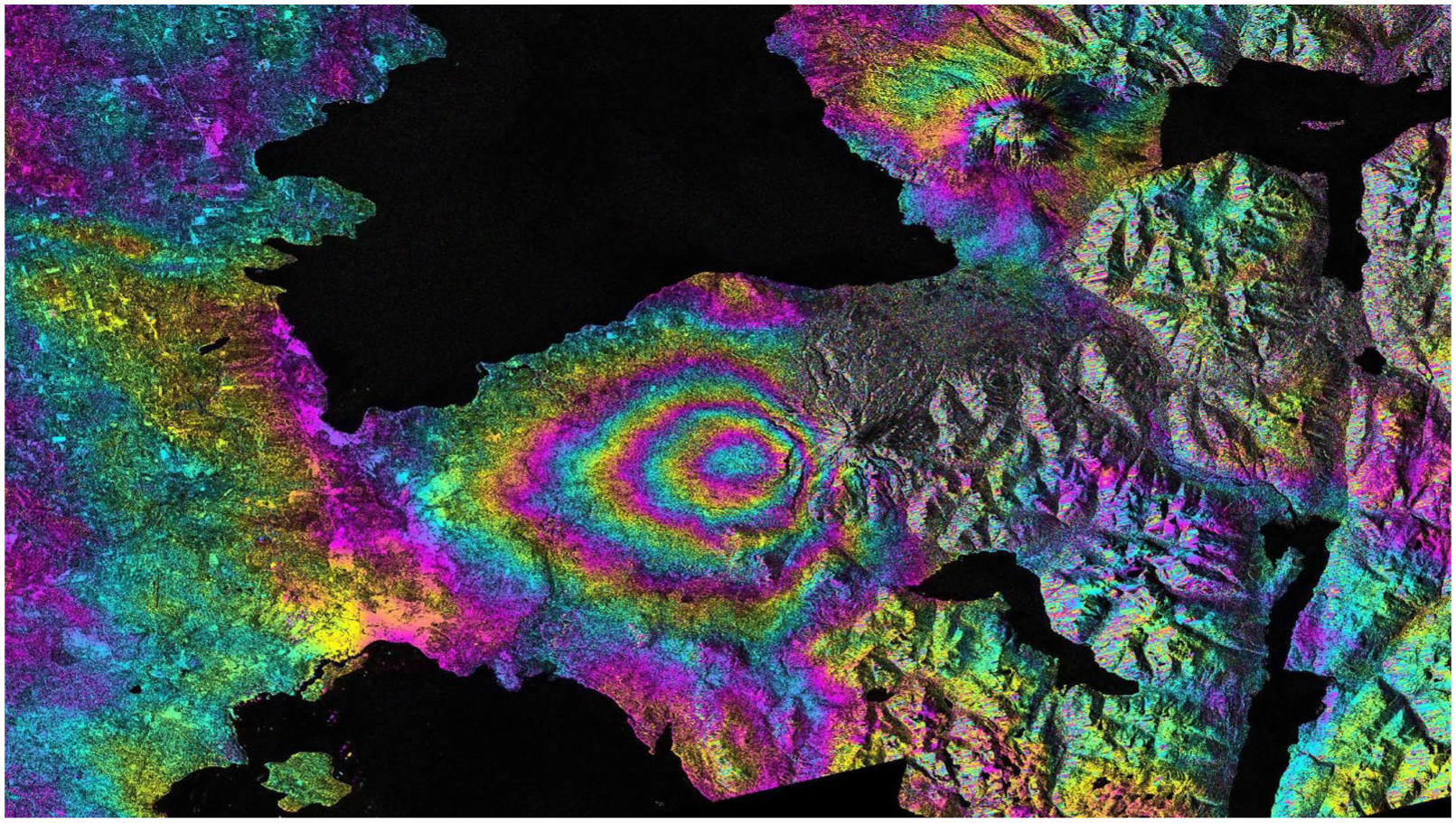
An interferogram made by NASA’s Jet Propulsion Laboratory using Sentinel-1 SAR imagery depicting the 2015 eruption of the Calbuco volcano in Chile. The rainbow fringes correspond to land sinking to the west of the volcano, whose summit lies near the dark shadow visible just to the right of the colorful circles.
Today, SAR interpretation is turning to machine learning algorithms trained to recognize patterns and changes in backscatter data (e.g. Barbat et al., 2021). This creates a multilayered black box between data and decisions involving the physical process of radar interactions with surfaces, the signal processing mathematics of SAR imagery formation, and, finally, another layer of abstract algorithmic evaluation of the imagery. Ultimately, an AI-interpreted SAR image, which might flag “anomalous activity,” remains triply opaque even once declassified and disseminated: first encoded in electromagnetic physics, then signal processing mathematics, and finally neural network weights. Compounding matters, GANs that simulate SAR imagery – in other words, electromagnetic computation simulations – are being refined in line with the laws of physics (as opposed to merely optics, which only visually mimic a SAR image) to improve automatic target recognition (S. Feng et al., 2024a). As with all machine learning models based on finite training data, however, it is difficult to accurately represent the real world. For instance, the Moving and Stationary Target Acquisition and Recognition (MSTAR) SAR dataset, produced by the U.S. Department of Defense’s Defense Advanced Research Projects Agency (DARPA) in the 1990s and still widely used, only includes Soviet ground military vehicles (Blasch et al., 2020; Li et al., 2023). The dataset includes all six major classes of such vehicles, but only 25 out of over 300 vehicle types (Ross et al., 1999). Moreover, the target data were all captured in flat, grass-covered environments in three states in the United States. While synthetic data can augment training data, models trained on MSTAR are evidently biased.
Russia’s war in Ukraine exemplifies how technical inscrutability undermines democratic accountability in warfare. While Ukraine’s Main Directorate of Intelligence (2024) stated that imagery from Finnish company ICEYE’s satellite allows tracking of Russian personnel movements, “reveal[ing] its military intentions with the aim of disrupting them,” this revelation occurs through automated pattern recognition trained on datasets that are likely classified. Commercial SAR providers like ICEYE and Capella have become direct participants in military intelligence. Ukraine’s intelligence directorate also claimed that one of ICEYE’s SAR satellites had enabled strikes against over 1,500 Russian targets. Nearly 4,200 SAR images had captured “370 airfields, 238 air defense and radio reconnaissance positions, 153 oil depots and fuel warehouses, 147 missile, aviation weapons and ammunition warehouses, and 17 naval bases” with 38% of the imagery used “for direct preparation of fire damage to the enemy” (Main Directorate of Intelligence, 2024). The resulting intelligence assessments emerge from technical processes that are not merely classified but also fundamentally unintelligible to all but a handful of experts, many of whom are employed by for-profit commercial firms using proprietary algorithms. Although the Ukrainian intelligence directorate refers to the commercial satellite as “the people’s satellite,” civilian populations affected by these targeting decisions have no capacity to evaluate the accuracy or legitimacy of SAR-based intelligence.
The speed of this transformation reveals how operational tempo can largely bypass not just democratic oversight, but human oversight altogether. As the commercial optical chief product officer of Maxar, a U.S. satellite services company and military contractor acquired for US$6.4 billion by a private equity firm in 2023 and renamed Vantor in 2025, explained, “[The war] shifted our mission from a company founded to map the world to one mapping a battle space that is changing very rapidly.” At the same time, the adoption of AI-driven algorithms has compressed processing times from “days or weeks” to “hours or minutes” (Pultarova, 2025). For example, ICEYE’s partnership with Polish AI firm Satim enables rapid automation identification of specific types of military equipment under tree cover without having a human in the loop. When such automated systems directly inform targeting decisions in near real-time, deliberative processes that might allow for human supervision become structurally improbable (e.g. Asaro, 2012).
The commercialization of SAR has worsened the democratic deficit. While commercial firms claim to expand access to SAR data (though not its interpretation), they remain accountable to investors and shareholders rather than public institutions. Many companies are not even publicly traded: Vantor, for instance, is privately held. The U.S. government’s reliance on commercial SAR providers has become so extensive that one industry analyst warned that a reduction in Ukraine-related funding “would be a hell of a bloody blow” for emerging SAR companies (Hitchens, 2025). This reveals the deep dependence of spatial imaging companies – many of which are rebranding, like Vantor, as a “software-driven spatial intelligence company” (Vantor, 2026) – on defense contracts. With dozens of Silicon Valley companies including SpaceX, Palantir, and Anduril pursuing defense contracts, greater scrutiny of the enmeshment of the military, tech, and venture capital, along with their reliance on data, is crucial (e.g. Merrill, 2025). Industry excitement is growing given the potential for multi-million-dollar contracts should the Trump administration’s proposed $175 billion Golden Dome missile defense system go forward. This would potentially see the U.S. place weapons in orbit in contravention of the 1967 Outer Space Treaty along with SAR and infrared sensors, fueling the growth of more-than-optical remote sensing. Yet reliance on federal contracts can also create vulnerabilities for both state and non-state actors. In 2025, when the Trump administration paused sharing intelligence with Ukraine, including access to the Global Enhanced GEOINT Delivery program operated by Vantor through a contract with the National Reconnaissance Office, it cut off a vital pipeline to Kiev of high-resolution satellite imagery. To avoid such situations, Vantor has since sought to provide “sovereign intelligence access” (Clover and Pitel, 2026) by partnering directly with European countries. This strategy exposes the tension of relying on U.S. government funds while trying to circumvent its authority.
Although satellite imagery is sold with the promise of knowledge and transparency, it is often only available to those who can pay to access it (or, ideally, collect it) and, crucially, know how to interpret it. Compared with optical photography, developing critical literacy around SAR data will prove far more challenging, which is why its production, dissemination, and adoption should provoke all the more critique. As Ulbricht and Egbert (2024: 1) argue, the government’s reliance on digital technologies and data “is not just a matter of state agencies overseeing technology companies but also of the state overseeing itself.” These dynamics depart dramatically from traditional state secrecy, which operates through institutional withholding of information that could theoretically be challenged through democratic processes, and shift to a form of structural opacity that operates through technical complexity. Whereas the anti-democratic nature of conventional military secrecy can be contested by means such as freedom of information laws, legislative oversight, or whistleblowing, SAR’s anti-democratic politics are embedded within its epistemology. Data can be declassified, yet it remains functionally inaccessible and ambiguous to public evaluation and scrutiny because both its production and comprehension require specialized knowledge of electromagnetics, physics, signal processing, and, increasingly, AI-based algorithmic decision-making. This creates a new form of illiberal power that operates not by withholding information, but by transforming reality into signals that only specialists can decode.
Conclusion
When cameras were spreading in the 1930s, Walter Benjamin (1972 [1931]) surmised, “‘The illiterate of the future’, it has been said, ‘will not be the man who cannot read the alphabet, but the one who cannot take a photograph (p. 25). But must we not also count as illiterate the photographer who cannot read his own pictures? Will not the caption become the most important component of the shot?” His prescient provocation holds even more weight with SAR imagery. Few can interpret a SAR image, even with the help of captions. Fewer still can generate one.
Our goal has been first to contribute to understandings in the social sciences and humanities of SAR data and second to underscore the need to foster public data literacy around SAR and the challenges of doing so. SAR imagery resembles optical photography, but it does not fit neatly into its lineage. Many commercial SAR data providers use the language of “seeing.” A representative for Capella (2020) contended, for instance, “If we can’t see what’s happening around us, we can’t make good decisions. SAR allows us, our first responders, our policy makers, and the world to see. That is critical.” But SAR does not see: it is a haptic, tactile process that sends and receives electrical signals. These invisible microwaves are increasingly contested as militaries seek to control the electromagnetic spectrum down to the narrowest wavelengths and faintest signals.
SAR technology, as an advanced type of electromagnetic sensor, is circulating at a serious juncture for photography. Just some years ago, people might have questioned the contents of a photograph, but not whether it was captured. Consider, for instance, the global controversy that erupted over the fuzzy black-and-white satellite photographs (technically, degraded optical imagery acquired by U.S. Keyhole-11 reconnaissance satellites (Livingston and Robinson, 2003)) exhibited by former U.S. Secretary of State Colin Powell at the United Nations Security Council in 2003 when he was making the case for war in Iraq (Herscher, 2014). The public questioned the contents of the photographs, but not whether they were taken. Today, however, GANs are making photographs easier to simulate than ever before, whether for malicious purposes such as deepfakes or for more lighthearted ones like inserting absent friends into selfies. All of this tests the assumption that photographs were actually shot. Yet even with the fundamentals of photography under assault, few seem to be questioning the veracity of optical satellite imagery, especially with its ever-higher clarity. In fact, satellite imagery is increasingly deemed necessary to “prove” that an event or atrocity actually happened. This relates to Susan Sontag’s (2005 [1973]: 115) observation that photography, whose original role was to more accurately record reality, has now become reality: “the real object is often experienced as a letdown.” More than just spurring disappointment, the visual determines reality: “Pics or it didn’t happen,” the chronically online comment (Schrag, 2015).
With faith in optical photography at a crossroads, SAR imagery may further challenge the preeminence of the visual. A new scopic regime may arise in which optical imagery continues to enthrall the public while intelligence is derived from the more-than-visual bands of the electromagnetic spectrum. Optical imagery still enchants. One need only consider the allure of the Blue Marble, the name bequeathed to the iconic image of Earth taken by astronauts onboard the Apollo 17 mission in 1972 (Wuebbles, 2012) (and now, ironically, the name of NASA’s series of mosaicked satellite images simulating a perfectly cloud-free Earth (NASA, 2025)), or the headline-grabbing photos of the planet snapped by astronauts onboard the Artemis II mission in 2026 on their way to the moon, which media outlets called “amazing” and “stunning.” Then there is the appeal of stories such as that of Saroo Brierley, who located his childhood home in India by trawling Google Earth satellite imagery for 3 years (Figlerowicz, 2015), as dramatized in the 2016 film Lion. And in an era when social media platforms like TikTok mediate wars (Primig et al., 2023), there is the virality of videos such as Vantor’s high-resolution imagery of the alleged 40-mile convoy of Russian tanks invading Ukraine. While all of this optical imagery occupies the public’s screens, SAR satellites pulse unseen and unfelt through cloud and darkness, across homes, harbors, and battlefields, their signals interpreted by technicians whose readings help determine what governments and companies do next.
SAR data is unlikely to mesmerize. Although remote sensing analysts and open source intelligence experts may be able to break down backscatter, the average person will struggle to make sense of the data, let alone use it to hold truth to power. A new and hybrid scopic regime is emerging in which visualizations of both optical and SAR imagery depict how the state orders the world, but which disguise where and how knowledge is amassed: within a hidden, haptic, electrical regime powered by the pulse, collection, and analysis of signals. Yet even the state’s reliance on the visual may endure: both scientists and military branches, including the U.S. Air Force, are investigating using AI to enable SAR-to-optical image translation (Cabrera et al., 2021; Seo et al., 2025). This technique would leverage the all-weather monitoring capacities of SAR while turning its fuzzy signals into pictures that facilitate human interpretability. So long as humans stay in the loop, visuals will have a place. SAR may be iconoclastic, but it is creating new worlds in its own image, too.
Footnotes
Acknowledgements
The authors are grateful to Amelia Urry and Lilian Kroth for organizing a workshop at the University of Cambridge in 2023 where this paper was first presented; the CLIMASAT team, which organized a seminar in which a second version was shared; and Christian Sirois, Deepak Tiwari, and Andrew Lapworth, who organized a conference session on “New Geographies of the Image” at the 2025 Royal Geographical Society – Institute of British Geographers’ Annual International Conference, where a third version was presented.

Ethical approval
No ethical approval was necessary to obtain for this research.
Informed consent
This article does not contain studies with human or animal participants performed by any of the authors, so informed consent was not required.
Funding
The authors disclosed receipt of the following financial support for the research, authorship, and/or publication of this article: The first author is also grateful for the support of a British Academy Visiting Fellowship (VF3102221) at the Department of Anthropology/Centre for Outer Space Studies at University College London.
Declaration of conflicting interests
The authors declared no potential conflicts of interest with respect to the research, authorship, and/or publication of this article.
Data availability statement
No data were generated for this research.