
Abstract
This study conducted a comprehensive geospatial analysis of wind energy siting suitability within the Southern African Power Pool region, employing Geographic Information Systems and multi-criteria decision analysis. By integrating key biophysical and infrastructural factors, including wind speed, proximity to power lines and roads, elevation, slope, and land cover this study evaluated potential locations for utility-scale wind farm development across 12 SAPP member countries. Comprehensive suitability maps were produced, categorizing areas from very low to very high potential based on a hybrid GIS-AHP framework. The analysis revealed significant spatial variations in suitability, identifying priority zones characterized by high mean wind speeds (exceeding 7–8 m/s), gentle slopes (0°–0.75°), and proximity to existing infrastructure. This study quantified suitable land areas, defining highly suitable parcels as contiguous clusters of high-potential pixels with a minimum mapping unit of 1 km2 to ensure technical and economic feasibility. Mathematical modeling using Weibull parameters yielded shape factors ranging from 3.10 to 3.80 and scale factors of 11.06 to 12.27 m/s at 50 m heights in high-potential zones. These findings provide a data-driven tool for policymakers and investors to identify priority zones for sustainable wind energy development, fostering regional energy security and cross-border cooperation within the SAPP.
Keywords
Introduction
The transition toward sustainable energy systems is a critical priority for the Southern African Power Pool, a regional body established to enhance electricity cooperation and security across 12 member states. While Southern Africa possesses vast, underutilized wind resources, the deployment of utility-scale wind farms is often hindered by fragmented planning and the lack of a unified regional suitability framework. Global reports from the International Renewable Energy Agency indicate that Africa's wind energy potential is immense, yet it remains the least exploited renewable resource on the continent due to infrastructural and technical barriers (IRENA, 2024). Furthermore, the Global Wind Energy Council emphasizes that regional power pools like SAPP require data-driven spatial planning to attract the investment-grade projects necessary for reaching net-zero targets (GWEC, 2024)
Despite the growing body of literature on wind energy in Africa, existing studies typically focus on individual nations such as South Africa (Szewczuk and Prinsloo, Wind Atlas for South Africa (WASA): Project overview and current status, 2010), Namibia (Kamati et al., 2022) often neglecting the cross-border infrastructure and topographic synergies that define the SAPP's integrated grid. Previous assessments frequently rely on local-scale modeling that does not account for the regional complexities of the Southern African plateau or the proximity to the shared SAPP transmission backbone (SAPP, 2021). Furthermore, many regional studies lack a standardized multi-criteria approach that balances technical feasibility with socio-economic and environmental constraints.
This study seeks to answer: To what extent can integrated GIS-AHP modeling identify cross-border wind energy priority zones within the SAPP that balance topographic feasibility with existing infrastructure proximity?
To address this question, we employ a multi-criteria decision analysis framework using the Analytic Hierarchy Process to weigh five critical siting factors: wind speed, elevation, slope, and proximity to both roads and power lines. By integrating these layers into a Geographic Information System, this study provides a harmonized suitability index across the SAPP domain. Unlike previous localized assessments, this research offers a preliminary spatial consistency check by qualitatively comparing identified high-suitability zones against existing and proposed wind farm locations. While recognizing the limitations of regional-scale data, this study provides a foundational tool for policymakers and investors to identify priority development corridors, thereby fostering regional energy security and sustainable infrastructure growth in Southern Africa.
Related work
The selection of optimal sites for wind energy development is a multi-dimensional challenge that requires balancing technical potential with economic constraints and environmental protection (Benti et al., 2023). In the context of the Southern African Power Pool (SAPP), a region characterized by vast geographic distances and a centralized transmission backbone (SAPP, 2021)., the integration of Geographic Information Systems (GIS) with the Analytic Hierarchy Process (AHP) has emerged as a worthwhile technique for managing large and often conflicting spatial criteria (Benti et al., 2023). This study synthesizes the existing literature by categorizing key determinants of wind energy feasibility into thematic constraints that influence the development of cross-border wind energy corridors.
Topographic and technical constraints
Technical suitability is primarily determined by the physical characteristics of the land and the quality of the wind resource (Metegam et al., 2024). Among these, wind speed is consistently identified as the most critical factor in suitability models. In some weighted analyses, wind speed accounts for as much as 42.7% of the total importance (Elmahmoudi et al., 2020). Wind turbines require a minimum cut-in speed to generate electricity, and areas with wind speeds below 4 m/s are typically considered unsuitable for utility-scale projects (Elmahmoudi et al., 2020). High-suitability zones are therefore those with stable and strong wind regimes, often exceeding 7 m/s and in some cases reaching above 8.5 m/s, ensuring optimal energy production (Elmahmoudi et al., 2020; Vale et al., 2020).
Topography further influences technical feasibility, particularly through slope and elevation. Flat or gently undulating terrain is preferred, as it reduces construction complexity and associated costs (Elmahmoudi et al., 2020). Slopes below 7% are generally considered optimal, while suitability declines significantly beyond this threshold (Shehab and Faisal, 2025).Many studies classify slopes above 10% as unsuitable due to the challenges of constructing turbine foundations and transporting heavy equipment (Ajaj et al., 2025). Elevation also affects wind performance, with certain altitude ranges such as 462–632 meters being associated with higher suitability in regional analyses equipment (Ajaj et al., 2025). Together, these topographic factors define the physical constraints within which wind energy projects can be efficiently developed.
Infrastructural and economic barriers
Beyond technical considerations, infrastructural and economic factors play a crucial role in determining project viability within the SAPP. Proximity to the transmission grid is particularly important, as it directly affects connection costs and energy losses. This factor is often ranked among the top criteria in suitability analyses, with weights such as 0.175 reported in some studies (Elmahmoudi et al., 2020). Areas located within 5 km of high-voltage transmission lines or substations are typically assigned the highest suitability scores, while suitability decreases progressively with increasing distance, often becoming unfeasible beyond 40 km (Vale et al., 2020). Additionally, safety considerations require maintaining buffer distances commonly around 500 meters from existing power lines (Ajaj et al., 2025).
Similarly, access to road infrastructure is essential for both the construction and maintenance of wind farms. The transportation of turbine components and regular site visits depend heavily on the availability of nearby roads, making this factor a key determinant of project cost efficiency (Shehab and Faisal, 2025). In multi-criteria decision models, road proximity may carry a weighting of approximately 6.8% (Elmahmoudi et al., 2020). Areas located within 5 to 10 km of road networks are generally considered highly suitable, whereas distances exceeding 40 km significantly reduce feasibility due to increased logistical challenges (Vale et al., 2020).
Justification for the integrated five-factor model
The selection of five core factors wind speed, elevation, slope, proximity to roads, and proximity to power lines is well supported by the literature as representing the primary determinants of wind energy suitability (Benti et al., 2023; Metegam et al., 2024). Although additional criteria such as land use and proximity to settlements are important for detailed site-level assessments, these factors mainly refine rather than define the initial suitability analysis. For example, settlement buffers ranging from 300 meters to 3 km are often applied to address social and environmental concerns (Ajaj et al., 2025). However, the five selected criteria capture the fundamental technical and geographic potential necessary for regional-scale planning (Metegam et al., 2024).
By focusing on these key constraints, this study addresses the complex and often contradictory requirements of wind energy development within SAPP. It balances the need for high-quality wind resources with the economic necessity of proximity to shared infrastructure across member states. This integrated and thematic approach moves beyond localized analyses, offering a comprehensive framework for identifying priority zones for wind energy development across the Southern African plateau.
Table 1 summarizes previous studies on wind energy potential and site selection methods across Southern African Power Pool (SAPP) countries, detailing the study areas, methodologies, evaluation criteria, and publication years.
Related studies.

Methodology
Analytical framework
The siting assessment was conducted using a
This framework allows both the physical and infrastructural characteristics of the SAPP region to be expressed numerically and compared on a common decision scale.
Selection of siting factors
Wind farm development is influenced by the terrain, accessibility, and grid connectivity. Based on the literature, technical standards, and regional infrastructure conditions,
Data processing and thematic layer development
Each factor was transformed into a spatial raster layer representing its influence on the wind farm potential. All layers were resampled to a uniform spatial resolution of 500 m using the bilinear interpolation method to preserve the continuity of wind speed gradients (Kiberet et al., 2025).
Proximity-Based layers
The Euclidean Distance was used to generate continuous surfaces for proximity to roads and transmission lines. Closer distances were assumed to be more suitable, whereas areas farther away incurred higher infrastructure costs.
Vector to raster conversion considerations
The conversion of vector data (such as power lines and roads) to raster format, necessary for weighted overlay analysis in GIS, may introduce several challenges. These include loss of spatial precision due to generalization of linear features into grid cells, edge effects where feature boundaries become less distinct, and potential misrepresentation of narrow or small features when raster cell size is coarsely relative to vector detail (Longley et al., 2015). Such effects can impact the accuracy of proximity measurements and suitability scores, especially near infrastructure edges. To mitigate these issues, an appropriate raster resolution was selected to balance computational efficiency and spatial detail, and preprocessing steps were applied to preserve feature integrity as much as possible. Nevertheless, residual uncertainties from rasterization should be acknowledged when interpreting the spatial suitability results.
Topographic layers
A 30 m SRTM DEM was used to derive the elevation and slope.
Land cover layer
The land cover was reclassified to emphasize areas with minimal ecological conflict. Natural vegetation and open land were considered more suitable, whereas wetlands, settlements, and dense forests were penalized.
All layers were resampled to a uniform resolution and spatially aligned before integration.
Criteria standardization
Because the variables have different units and measurement scales, each was transformed to a
Three transformation types were applied.
Normalization ensured that all factors could be logically aggregated in the final suitability model.

Weight derivation using AHP
The relative importance of each factor was determined through a pairwise comparison matrix using Saaty's fundamental scale (Mengstie et al., 2024). The weights were calculated to reflect the high priority of wind resource quality and proximity to the SAPP transmission backbone. Type equation here.
The weight vector was calculated using the normalized principal eigenvector method: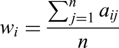
To ensure the logical coherence of the decision-maker's judgments, the Consistency Index ($CI$) was calculated as: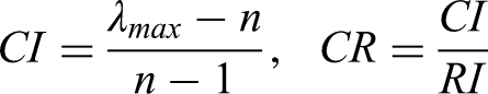
The Consistency Ratio was strictly monitored to ensure it remained below the 0.1 threshold (Alamrew et al., 2024). In this study, the final model achieved a CR of 0.045, indicating a highly consistent and reliable weighting scheme.
These weights were later converted into

Consistency Ratio = 0.045 (Matthew, 1982; Mengstie et al., 2024)
Weighted overlay suitability modeling
The final suitability index was generated using the Weighted Linear Combination method. This process involved multiplying each standardized factor layer by its respective AHP weight and summing them to produce a composite suitability score for every pixel in the study area. The mathematical model is defined as:
Where:
This additive approach allows for the compensatory nature of siting factors, where high wind resource potential can offset moderate distances from infrastructure (Elmahmoudi et al., 2020; Metegam et al., 2024). Wind turbines require a minimum cut-in
Exclusion zones and constraints
To ensure the final map reflects only technically and environmentally viable land, a Boolean exclusion mask was applied. Areas falling within these “No-Go” zones were assigned a value of 0 and removed from the final calculation.
Data Sources: Primary exclusion data included the World Database on Protected Areas for ecological constraints and OpenStreetMap for human settlements, water bodies, and existing industrial zones.
Setback Buffers: Following established safety and environmental protocols, mandatory buffers were applied, including a 500-meter setback from major settlements to minimize noise impact and a 250-meter buffer from permanent water bodies (Ajaj et al., 2025; Vale et al., 2020).
Environmental Integrity: By applying these masks separately from the weighted layers, the model ensures that high-priority conservation areas are completely removed rather than simply receiving a low score, thereby maintaining the environmental rigor required for regional power pool planning (Benti et al., 2023; Metegam et al., 2024).
Classification and thresholding
The continuous suitability scores were classified into five qualitative levels Very Low, Low, Moderate, High, and Very High using the Jenks Natural Breaks optimization method. This method was chosen because it minimizes the variance within each class while maximizing the variance between classes, making it highly effective for identifying distinct suitability tiers in the non-uniform wind speed and topographic datasets of the SAPP region (Kiberet et al., 2025; Mankelkelot et al., 2026). This classification allows for a clear identification of “priority zones” that are most suitable for immediate investment-grade feasibility studies (Benti et al., 2023).
Model verification
To assess the credibility of the results, the locations of existing or proposed wind energy installations in the SAPP countries were cross-checked against the high-suitability zones. The agreement between the modeled suitability and real-world installations provided qualitative validation of the workflow.
Results and discussion
Table 2 presents the land area distributions and percentages within specified distance ranges from power lines for each SAPP member country, highlighting spatial accessibility to the electrical grid.
Distance from the power line.

Figure 1 illustrates the spatial distribution of distances from existing power lines across a region within the Southern African Power Pool (SAPP). Using a gradient color scheme, it categorizes areas by proximity to power infrastructure, which is a critical factor in evaluating wind energy-siting suitability. The distance classes ranged from 0–5 km (green) to over 80 km (dark purple), indicating areas with varying degrees of accessibility to the power grid. Proximity to transmission lines significantly influences the feasibility and cost-effectiveness of wind energy projects, as shorter distances typically reduce the transmission infrastructure costs and energy losses. This map serves as a key input in the multi-criteria geospatial analysis for identifying optimal wind energy sites in the SAPP region.

Distance from the power line map.
Table 3 shows the land area distributions and percentages within defined distance ranges from roads across SAPP countries, reflecting the accessibility for the construction and maintenance of wind energy infrastructure.
South-Distance from road.
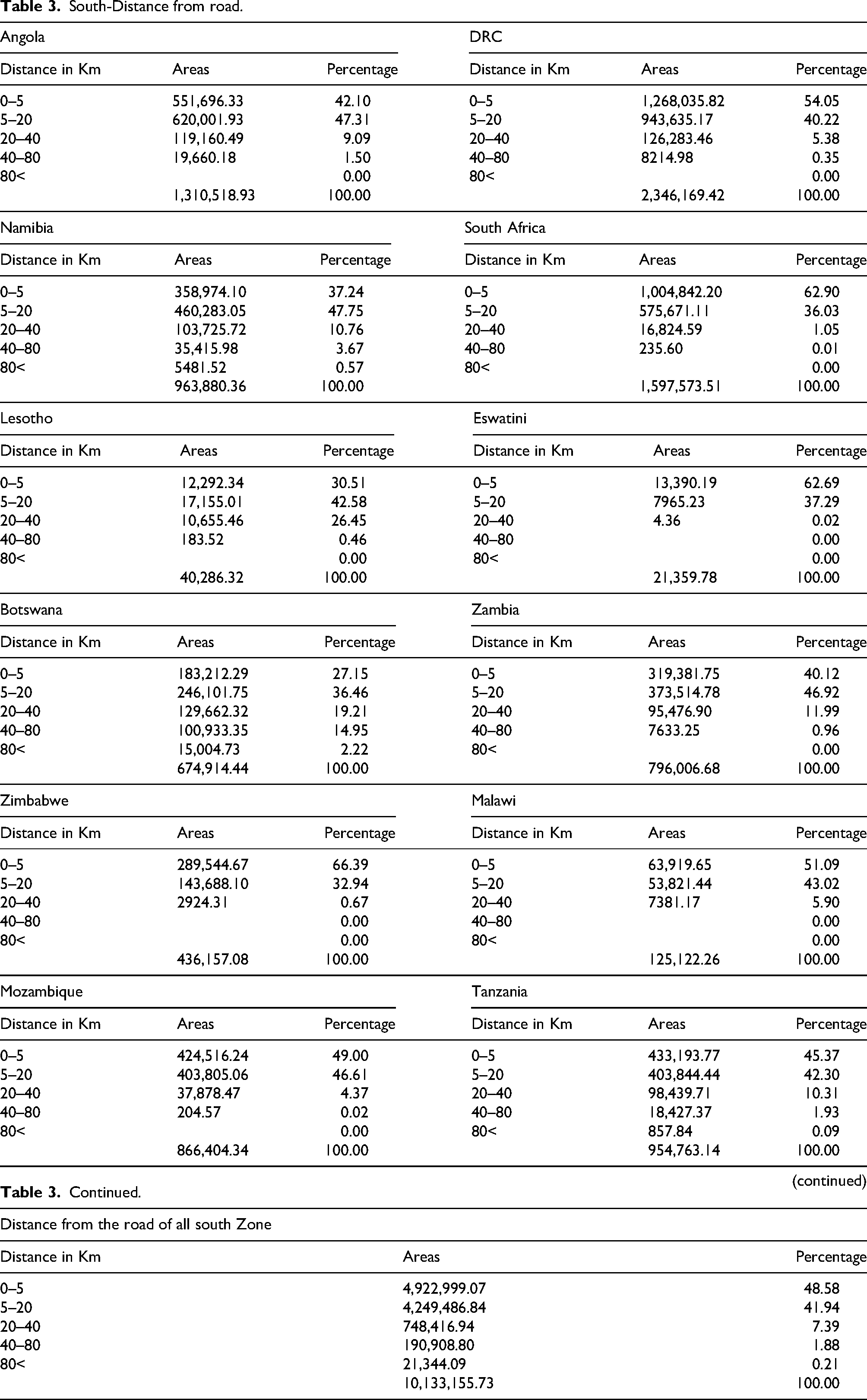
Figure 2 presents the spatial distribution of distances from existing road networks within the Southern African Power Pool (SAPP) region, categorized into five classes ranging from 0–5 km (lightest shade) to > 80 km (darkest shade). Road accessibility plays a crucial role in the siting of wind energy projects, affecting the transportation of construction materials, turbine components, and maintenance logistics. Areas closer to roads are generally more favorable for wind energy development because of reduced infrastructure and transportation costs. This map is a vital layer in geospatial analysis for wind energy siting, contributing to a comprehensive assessment of logistical feasibility across the SAPP region.

Distance from the road.
Table 4 distributions and percentages within defined distance ranges from roads across SAPP countries, reflecting accessibility for the construction and maintenance of wind energy infrastructure.
South elevation.
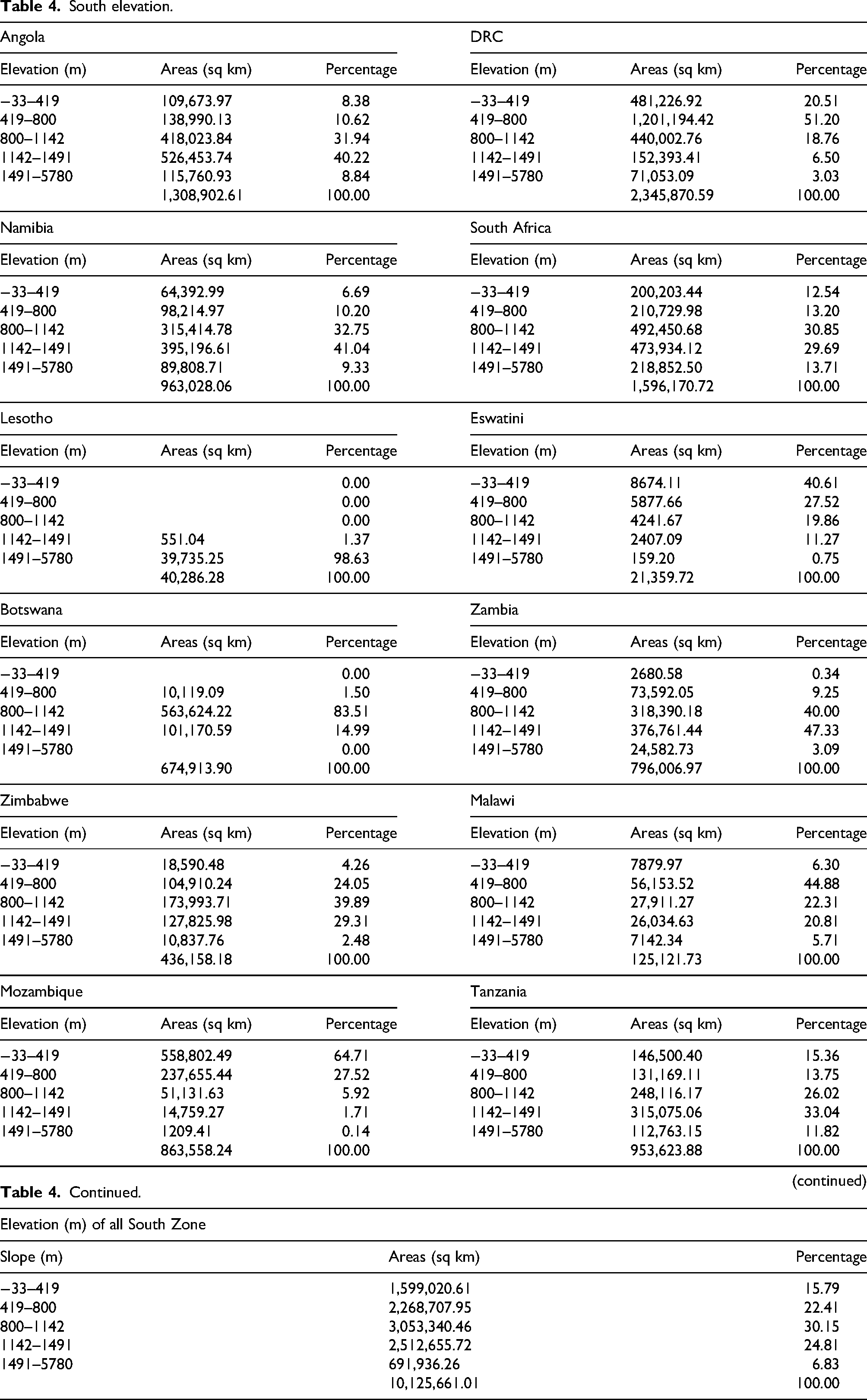
Figure 3 displays the topographic variation across the Southern African Power Pool (SAPP) region, classified into five elevation bands ranging from below sea level (−33 m) to 5780 m above sea level. Lower elevations (green) dominated the northern and eastern parts of the region, whereas higher elevations (brown to dark brown) were concentrated in the central and southern zones. Elevation influences wind energy siting because of its effect on wind speed and turbine performance, as wind tends to be stronger and more consistent at greater altitudes. Steep terrain can also pose challenges for construction and maintenance. This map is essential for the geospatial evaluation of wind energy potential, helping to identify locations where elevation supports efficient and sustainable wind farm development.

Elevation.
Table 5 displays the land cover classifications with areas and percentages for various land use types within the SAPP countries, emphasizing environmental and land use suitability for wind farm development.
South land cover.
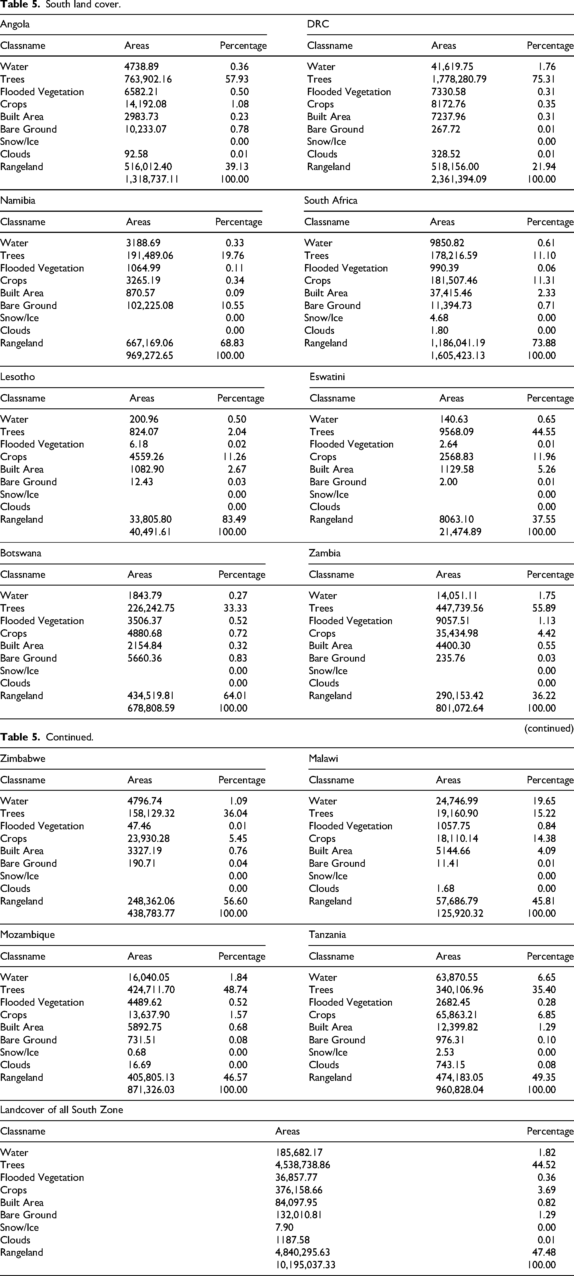
Figure 4 illustrates the distribution of various land cover types within the Southern African Power Pool (SAPP) region using satellite-derived classifications, such as water, trees, flooded vegetation, crops, built areas, bare ground, snow/ice, clouds, and rangeland. Land cover significantly affects the suitability of sites for wind energy development in Brazil. For instance, areas with dense tree cover or protected ecosystems may present environmental constraints, whereas open rangelands and bare ground are generally more favorable for wind farm construction because of easier accessibility and minimal ecological disturbance. Built-up areas may limit turbine placement because of space restrictions and safety regulations. As such, this land cover map is a critical component of the geospatial multi-criteria decision analysis aimed at identifying optimal locations for wind energy siting across the SAPP region.

Land cover.
Table 6 provides slope degree classifications alongside land areas and percentages across SAPP countries, indicating terrain steepness relevant to construction feasibility and turbine stability.
South slope.
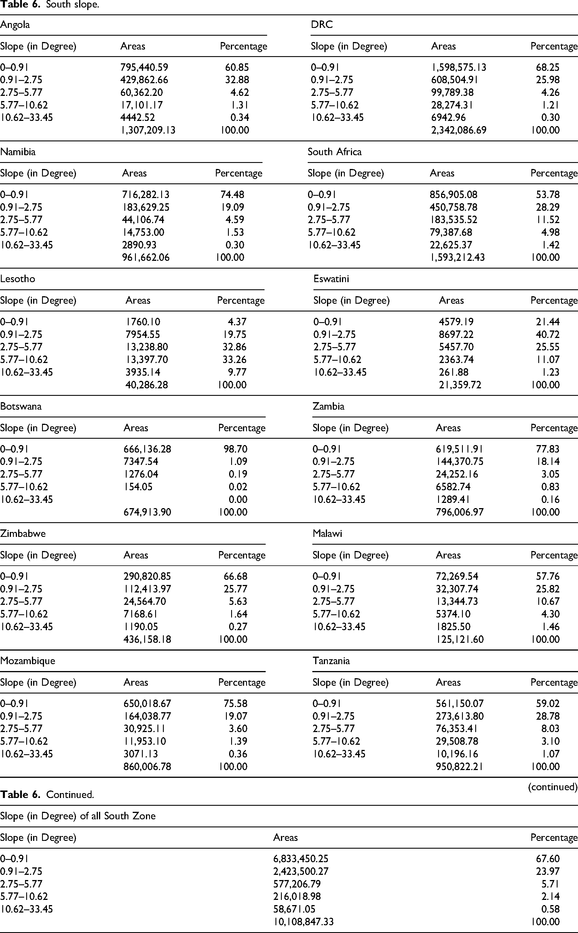
Figure 5 shows the variation in terrain steepness across the Southern African Power Pool (SAPP) region, categorized by degree ranging from 0°–0.75° (flat, shown in light green) to 9.72°–32.21° (steep, shown in red). The slope is a critical factor in wind energy siting as it directly impacts construction feasibility, turbine stability, and access for maintenance. Flatter areas are generally preferred for wind farm development because of reduced construction complexity and cost. Steep slopes can increase foundation requirements, cause erosion risks, and limit the development of road and grid infrastructure. This map is an essential component of the multi-criteria analysis framework used to identify technically suitable and economically viable sites for wind energy installations in the SAPP region.

Slope.
Table 7 Classifies wind energy suitability levels with associated land areas and percentages across SAPP member countries, derived from an integrated multi-criteria geospatial analysis.
South suitability.

Figure 6 displays the overall wind power suitability levels across the Southern African Power Pool (SAPP) region, which were synthesized from multiple geospatial criteria, including wind speed, distance to infrastructure (roads and power lines), elevation, slope, and land cover. Suitability was classified into five levels: Very Low (red), low (orange), moderate (yellow), high (light green), and Very High (dark green). Areas rated as “Very High” or “High” are considered most favorable for wind energy development because of optimal physical and infrastructural conditions. Conversely, “Very Low” and “Low” suitability zones present significant constraints, such as steep terrain, poor access, or environmental conflicts. This comprehensive suitability map supports informed decision-making by helping policymakers, investors, and planners identify priority zones for sustainable and economically viable wind energy projects in the SAPP region.

Restriction factors influencing wind farm site selection across the Southern African power pool (SAPP) region. The map shows exclusion zones including protected areas, wetlands, water bodies, and urban settlements. These areas were masked out in the suitability modeling to avoid environmentally sensitive or socially restricted locations, ensuring sustainable wind energy development.
Table 8 shows the distribution of average wind speed ranges with corresponding land areas and percentages across SAPP countries, illustrating the spatial variation in wind resource potential within the region.
South wind speed.
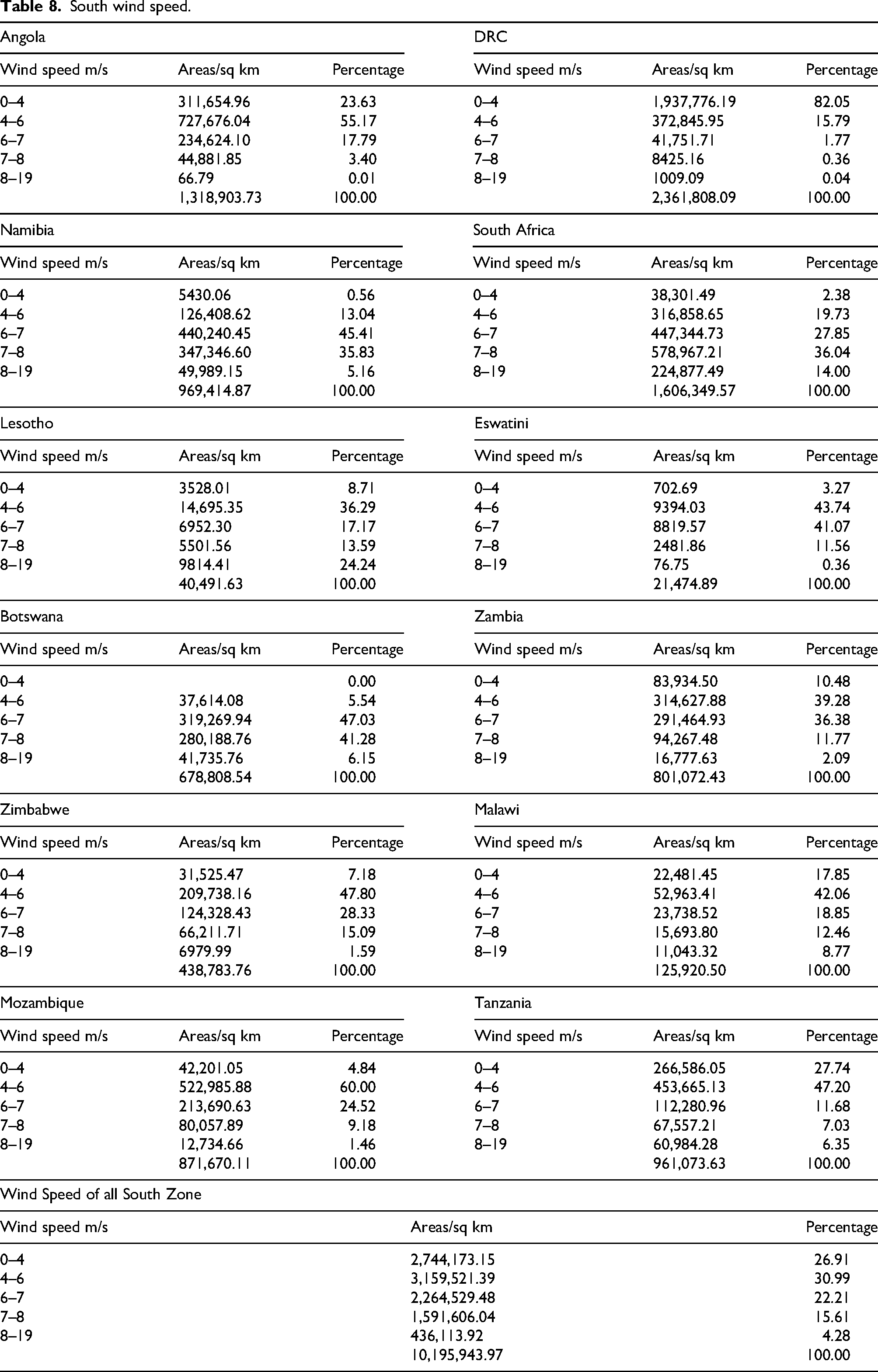
Figure 7 illustrates the spatial distribution of average wind speeds across the Southern African Power Pool (SAPP) region, categorized into five classes ranging from 0–4 m/s (lightest shade) to 8–19 m/s (darkest shade). Wind speed is the most fundamental criterion for assessing the potential for wind energy generation, as the energy output is directly proportional to the cube of the wind velocity. Regions with higher wind speeds are particularly important. This map plays a crucial role in identifying zones with strong wind resources, guiding the prioritization of high-potential locations for further feasibility studies, and investing in renewable energy infrastructure.

Wind speed map.
Definition of the analysis domain
In this study, the “South Zone” is defined as the total terrestrial area encompassing the 12 member states of the Southern African Power Pool, specifically excluding all offshore and maritime territories. This analysis domain covers approximately 10.18 million km2, providing a comprehensive terrestrial evaluation of wind energy potential across Angola, Botswana, the Democratic Republic of Congo, Eswatini, Lesotho, Malawi, Mozambique, Namibia, South Africa, Tanzania, Zambia, and Zimbabwe (SAPP, 2021). By focusing strictly on land-based siting, the model prioritizes regions where grid integration and road accessibility are technically feasible within existing national infrastructures.
AHP consistency and methodological rigor
The weighting of the five primary siting factors wind speed, proximity to power lines, proximity to roads, elevation, and slope was validated using the Analytic Hierarchy Process to ensure decision-making reliability. Following the established standards in geospatial multi-criteria decision analysis, a Consistency Ratio of
Furthermore, the integration of these weights allows for a balanced assessment where technical wind potential is tempered by logistical feasibility. This approach is consistent with suitability analyses in other domains, such as sustainable ecotourism site selection in Bahir Dar, where AHP consistency was paramount in balancing ecological sensitivity with infrastructural (Mankelkelot et al., 2026).
Land-use exclusion and suitability distribution
To ensure the practical and ethical viability of the proposed wind energy sites, a binary exclusion mask was applied to the SAPP region. This process involved the strict removal of “Built Areas” (urban settlements), “Water Bodies,” “Flooded Vegetation,” and “Protected Areas” from the final suitability results. This urban and land-use exclusion rigor is a critical step in modern GIS-AHP frameworks to avoid socio-environmental (Mankelkelot et al., 2026; Mengstie et al., 2024).
The results of the suitability modeling indicate significant spatial variation across the South Zone:
Very High Suitability: 25.56% (approx. 2.60 million km2) of the terrestrial area is classified as highly favorable, primarily due to the overlap of high wind speeds and gentle slopes. High Suitability: 22.30% (approx. 2.27 million km2) shows strong potential with minor infrastructural or topographic constraints.
Marginal to Low Suitability: Areas categorized as “Low” (23.57%) or “Very Low” (3.51%) are typically restricted by steep terrain (slope > 10°) or extreme distance from existing power lines (Table 2, Table 6).
Wind speed analysis further corroborates these findings, with 4.28% of the region experiencing optimal speeds between 8–19 m/s, while the majority of the landmass (30.99%) falls within the 4–6 m/s range. The concentration of “Very High” suitability zones in countries like Namibia (48.48%) and South Africa (62.81%) highlights these nations as primary candidates for utility-scale wind farm expansion within the SAPP framework.
Conclusion
This study presents a comprehensive geospatial analysis of wind energy siting suitability across the Southern African Power Pool (SAPP) region by integrating critical biophysical and infrastructural factors using Geographic Information Systems (GIS) and multi-criteria decision analysis. The Analytic Hierarchy Process (AHP) was applied to derive weighted criteria, which, combined with spatial data on wind speed, proximity to roads and power lines, elevation, slope, and land cover, yielded detailed suitability maps. The results revealed considerable spatial variability in wind energy potential, with regions characterized by higher wind speeds, gentle slopes, favorable elevation, and proximity to existing infrastructure identified as the most suitable for wind farm development. The identification of extensive contiguous suitable land parcels averaging 36.810 km2 underscores the feasibility of utility-scale wind projects in the region. Validation against existing installations further corroborated the effectiveness of the proposed suitability framework. These findings offer valuable, data-driven insights to support policymakers, investors, and energy planners in prioritizing zones for sustainable wind energy deployment, thereby contributing to the advancement of renewable energy integration and energy security in Southern Africa.
Footnotes
ORCID iDs
Institutional review board statement
The authors declare that the content of this study complies with ethical standards. The authors confirm that this paper has not been published previously, it is not under consideration for publication elsewhere and is not under consideration for publication elsewhere.
Informed consent statement
Not applicable.
Author contributions
All authors contributed equally to this manuscript. All authors have read and agreed to the published version of the manuscript.
Funding
The authors received no financial support for the research, authorship, and/or publication of this article.
Declaration of conflicting interests
The authors declared the following potential conflicts of interest with respect to the research, authorship, and/or publication of this article: All authors declare that the research was conducted in the absence of any commercial or financial relationships that could be construed as potential conflicts of interest.
Data availability statement
The data for this study are available from the corresponding authors upon request.