
Abstract
At a recorded production of 2·5 t Au and mill recovered grade of 17 g/t Au, Clogau is the largest and richest mine in the Dolgellau gold-belt and is the most prolific gold producer in the United Kingdom. The main period of production commenced in 1861 and ended in 1911, with intermittent production between 1983 and 2007. The principal gold-quartz bearing Main reef can be traced for about 3 km along strike, trending approximately NE–SW and dipping between 60°SE and 90°SE. The reef system pinches and swells, changes strike, and splits into a number of major and minor branches. Reef width is variable, ranging from 6 m to a few centimetres. The reef is internally complex and composed of swarms of narrow sub-parallel quartz veins separated by sheets of country rock. The gold-bearing vein segments within the composite reef package are discontinuous, though may locally possess bonanza grades running at 1000s g/t Au. The predictability of the gold-rich segments is poor, but has been shown to be related to presence of the Clogau Formation (black-shale), interactions of the reef fault with greenstone sills, and/or reef splitting to form discrete ore shoots.
Introduction
The Dolgellau gold-belt has been subject to renewed exploration interest since 2009. The area is characterised by mineralised quartz reefs [The term ‘reef’ is used to describe a composite structure comprising of a number of quartz veins, which may or may not be economic.] with very local, but extremely rich gold pockets. The host reefs comprise ribbon veins emplaced in a Cambrian greywacke-black shale sequence known as the Clogau Formation (Figs. 1–4).
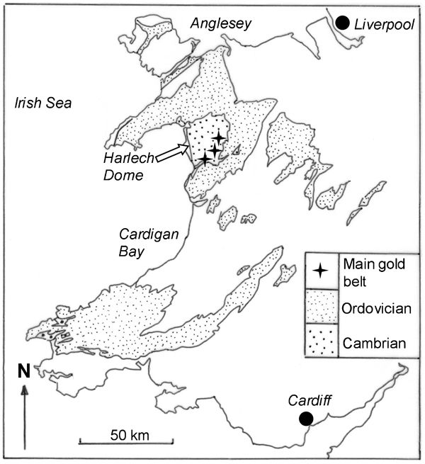
Gold-belt location and setting in Wales. The gold-belt lies on the E flank of the Harlech dome structure
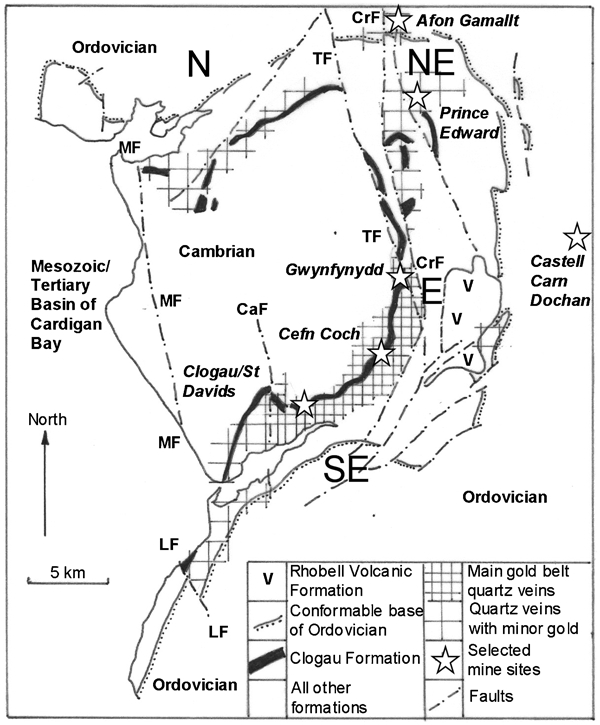
Gold-belt and associated quartz veins in relation to the Harlech dome, fault systems and outline of the lower Palaeozoic stratigraphy. Locations of some mine sites shown [CaF: Caedeon-Bodlyn fault; CrF: Craiglaseithin fault; LF: Llanegryn fault; MF: Mochras fault; TF: Trawsfynydd fault]
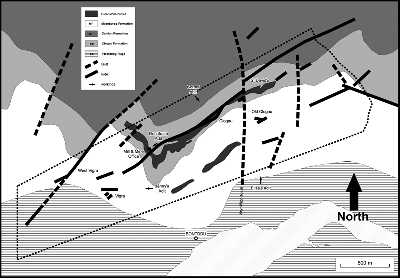
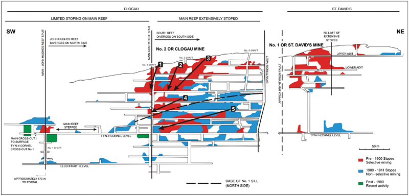
Schematic map of Clogau mine area (dotted line area) and local geology. Trend of reefs is NE–SW. The Bryntyrion fault (thick N–S dashed line) separates the Clogau section (W) and the St David's section (E) of the workings (After Clogau Gold Mines PLC)
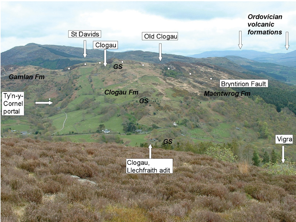
View looking approximately NE along the line of the Clogau Main reef. The main stratigraphic formations are labelled, and GS shows the outcrop of the No. 3 greenstone sill
Between 1860 and 1911, the gold-belt produced the largest quantity of gold (4 t Au) from any region in the United Kingdom (MacLaren, 1908; Owen, 1950; Morrison, 1975; Foster–Smith, 1977; Hall, 1975, 1988; Dominy and Phelps, 1997). The Clogau and Gwynfynydd mines produced 2·5 t Au and 1·4 t Au respectively, with a further 0·15 t Au reported from various smaller mines and trials. The recorded total mill recovered production for the gold-belt is approximately 280 000 t at 15 g/t Au, though this figure is misleading due to 20 to 30% gold loss during processing and potentially unreported production (Owen, 1950; Morrison, 1975; Hall, 1975, 1988; Allen and Jackson, 1985a; Dominy, 2012).
The focus of recent work at Clogau has been the review of historical data and published works to elucidate ore controls in support of mine exploration (Dominy, 2011, 2012). This contribution is the first in a modern context to substantively document gold mineralisation at the mine.
Clogau mine
Clogau mine comprises the Clogau and St David's workings. The St David's mine was initially worked for copper when in 1854, gold was found in supposed waste material mined in 1836 (Huddart, 1904; MacLaren, 1908; Morrison, 1975; Hall, 1975, 1988).
Official production is recorded for the period 1860 to 1911 (Hall, 1975, 1988), where 150 000 t yielded a mean recovered grade of 17 g/t Au. The estimated mine head grade lies in the range 21 to 24 g/t Au.
The Clogau and St David's mines are connected via the Ty'n-y-Cornel level and geologically separated by the Bryntyrion fault (Figs. 3–6). Most gold was sourced from the Clogau workings. Clogau comprises two main levels, the Llechfraith and Ty'n-y-Cornel. Both levels were driven on the NE-trending Main reef. An extensive area of stoping occurs in the NE part of the mine, along the Ty'n-y-Cornel level, extending 150 m along the level and 120 m up to the surface (Fig. 6). This marks the largest known ore shoot(s) and occupies ground between the No. 2/No. 5 shaft and the Bryntyrion Fault. The No. 2/No. 5 shaft marks the site of the split between the Main and South reefs (Fig. 6). The South reef was developed and stoped NE towards the Bryntyrion fault, though the level of stoping is unknown.
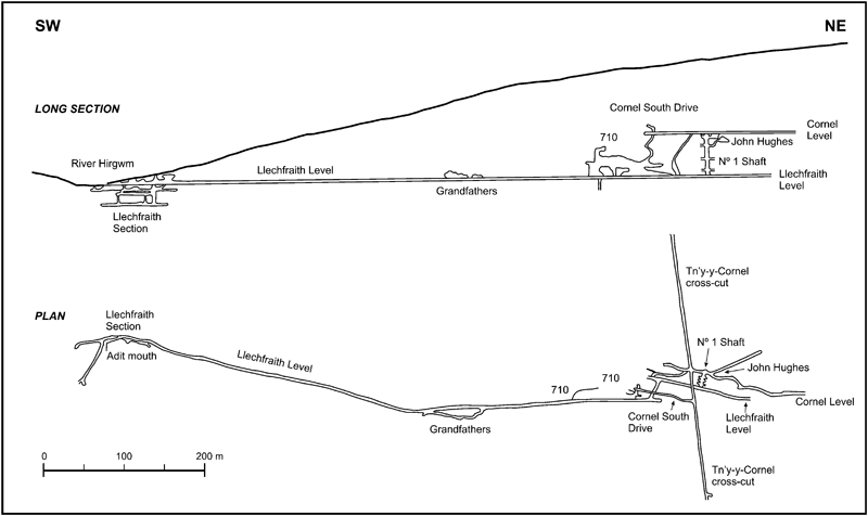
Long-section and plan of Clogau workings from the Llechfraith portal to the No. 1 shaft. Shows Llechfraith and Ty'n-y-Cornel levels and key areas (modified and redrawn from unpublished material of Clogau Gold Mines PLC)
Clogau-St David's Main reef vertical longitudinal projection from No. 1 to No. 2/No. 5 shaft, across the Bryntyrion fault and into the St David's workings. Historical stoping regimes shown. For discussion, see text. Note that the No. 5 shaft below the Ty'n-y-Cornel level is often referred to as the No. 2 shaft. Strike length of projection approximately 700 m (modified from Hall, 1975 and historical information)
Geological background
Regional geology
The Dolgellau gold-belt occurs within the northern part of the Welsh lower Palaeozoic basin, a marginal basin on the SE side of the former Iapetus Ocean (Fig. 1; Andrew, 1910; Allen and Jackson, 1985a, 1985b; Brenchley et al., 2006; Woodcock, 1990; Howells, 2007; Rushton and Molyneux, 2011). The basement is late Proterozoic with calc-alkaline intrusions and volcanic rocks. The basin was initiated in the early Cambrian with subsidence and infilling continuing to Early Devonian times. The main features of basin fill include:
Lower Devonian – fluviatile sequence preserved in SE Wales and inferred to be present over N Wales
Silurian – turbidites and mudstones
Ordovician – fine sediments, widespread volcanism, and local unconformities
Cambrian – turbidites and mudstones which are the principal gold-belt host rocks.
A Cambrian-early Devonian fill of 14 km in north Wales was inferred by Soper and Woodcock (2003). Basin development was terminated by the onset of the Acadian Orogeny (390–400 Ma). Folding, very low-grade metamorphism and cleavage development accompanied the Acadian event. Uplift and deep erosion took place during the Middle Devonian.
Gold-belt geology
The gold-belt occurs around the margins of the Harlech Dome, which brings a 4 km thick sequence of Cambrian strata to the surface (Figs. 1 and 2; Table 1). The core of the gold-belt forms an arc along the outcrop of the Cambrian Clogau Formation between the Clogau and Gwynfynydd mines (Fig. 2). Associated mineralisation occurs along the rest of the Clogau Formation outcrop and in younger Cambrian strata. Outlying mines (Afon Gamallt and Castell Carn Dochan) occur in Ordovician strata. Major Ordovician volcanic centres occur adjacent to the dome. These include Cader Idris to the S, Aran to the SE and Snowdon to the N. The small early Ordovician (Tremadocian) Rhobell volcanic centre occurs close to the gold-belt (Kokelaar, 1988). Sills and dykes related to Ordovician volcanism are emplaced in the Cambrian and Ordovician rocks (see Allen and Jackson, 1985a; Shepherd and Bottrell, 1993; and Platten and Dominy, 2009, for more local detail).
The Cambrian and early Ordovician Sequence in the Harlech Dome and relations with gold mineralisation*
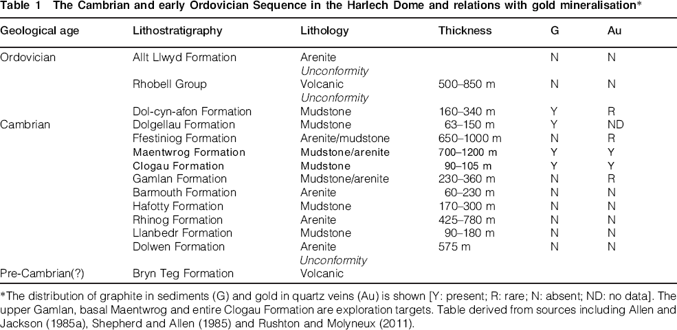
The distribution of graphite in sediments (G) and gold in quartz veins (Au) is shown [Y: present; R: rare; N: absent; ND: no data]. The upper Gamlan, basal Maentwrog and entire Clogau Formation are exploration targets. Table derived from sources including Allen and Jackson (1985a), Shepherd and Allen (1985) and Rushton and Molyneux (2011).
Gold-belt mineralisation
Reef structure
Regionally, the reefs form an array of E–W to NE–SW trending, generally steeply dipping structures (Shepherd and Bottrell, 1993; Platten and Dominy, 2009). The reefs are internally complex and comprise swarms of sub-parallel veins (1 to 300 mm) separated by country rock sheets, giving a total width of up to 6 m (Fig. 7). Medium to intense wall rock alteration rarely extends 0·5 m beyond the reef margin. It is usually characterised by calcite (dominantly), dolomite and/or pyrite. The gold-bearing vein(s) within the reef package are narrow (<0·5 m) and discontinuous (generally <10 m), effectively forming small bonanza grade pockets or sub-shoots within the main shoots.
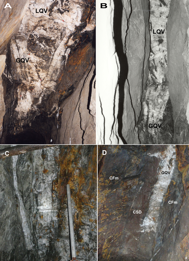
Clogau Main reef on the Ty'n-y-Cornel level. (A) Laminated gold-quartz veins in William's stope pillar cut by late-quartz veins; width of view 1·75 m. (B) Laminated gold-quartz veins in William's stope backs effectively replaced by late-quartz veins; width of view 1 m. (C) Laminated gold-quartz veins at No. 2 shaft where South reef splits from Main reef; width of view 1·5 m. (D) Gold-quartz veins and Clogau stone dyke east of No. 1 shaft; width of view 1·5 m [GQC: gold-quartz vein; LQV: late-quartz vein; CSD: Clogau stone dyke; CFm: Clogau Formation]
Stratigraphic controls on gold mineralisation
Gold occurs principally where the reefs intersect the pyritic, graphite-bearing Clogau Formation (Fig. 2 and Table 1). Reefs cutting the lower Maentwrog Formation can be auriferous and minor gold occurrences occur at higher stratigraphic levels. Reefs below the Clogau Formation show a much sharper gold cut-off, gold only appearing within the top 40 m of the Gamlan Formation. The presence of methane in fluid inclusions allowed Bottrell et al. (1988) to show that gold deposition was related to the interaction between carbonaceous mudstones and gold-bearing fluids.
Timing of mineralisation relative to the Acadian events
The reefs were widely considered to be post-Acadian in the past (Shepherd and Bottrell, 1993), but recent work shows that the reefs pre-date the main Acadian deformation event (Dominy and Platten, 1999; Mason et al., 1999; Platten and Dominy, 1999). Gross reef structures in the main gold-belt show little evidence of deformation. The most common and conspicuous Acadian features are the gently inclined, late-quartz veins (elephant quartz or alpine-type veins) found cutting reefs emplaced in mudstone host rocks. These quartz-dominated veins are associated with approximately vertical extension of the reefs during Acadian cleavage formation.
Style of mineralisation
Dolgellau mineralisation shows many similarities to other turbidite-hosted deposits such as those in Australia (Central Victorian goldfields: Ramsay et al., 1998); Bolivia (Liphichi-Maria Louisa belt: Dominy et al., 2010); Canada (Meguma Terrain, Nova Scotia: Mawer, 1986) and China (Guizhou: Lu et al., 2005). On a global scale, reef gold deposits that display similar very high-grade localised pocket characteristics include the Engineer mine (Atlin, BC, Canada: Dominy and Platten, 2012), Maxwell's mine (Inglewood, Victoria, Australia: Cahill, 2008) and the Sixteen-to-One mine (Alleghany, California, USA: Cooke, 1947).
Gold mineralisation in the gold-belt is orogenic in character associated with regional tectonic features, dominated by quartz veins bearing native gold and sulphides. An alternative classification of turbidite-hosted (e.g. black shale or slate-hosted) quartz-carbonate veins is also appropriate.
Mine geology
Stratigraphy
The Gamlan, Clogau and Maentwrog Formations crop out in the mine area (Table 1 and Figs. 3 , 4). The Main reef system is emplaced in the Clogau Formation at surface and at depth in the mine. The Main reef outcrop lies in Clogau Formation, but the extension SW of the Llechfraith portal may crop out in Maentwrog Formation as the cover thickness increases. The Ty'n-y-Cornel cross-cut shows a dip section from the upper Gamlan Formation through the Clogau Formation (between 230 and 430 m) into the lower part of the Maentwrog Formation (Fig. 8).
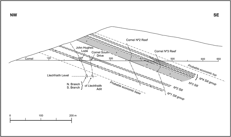
Simplified geological cross-section along the Ty'n-y-Cornel cross-cut to illustrate the locations of reef/sill intersections. The stratigraphy below the cross-cut is based on projection of cross-cut data. No fault displacements are shown associated with the reefs. Black shale and greenstone are present on the Llechfraith level, which lie below the projected economic base. The Cornel No. 2 and No. 3 reefs are only seen in the cross-cut, projections above and below this level are inferred. The Nos. 1 to 4 sills/sill groups are 8, 2, 20–50 and <10 m in thickness respectively (modified and redrawn from unpublished material of Clogau Gold Mines PLC)
Gross reef structure
The Clogau Main reef crosses the crest of an open N–S trending, S–plunging anticline near the Llechfraith portal (Fig. 3). The bulk of the mined area lies in the E limb of this fold. Here the reef host rocks dip to the SSE, locally to the S, at moderate angles (20–40°). The reef is slightly oblique to the host rock strike. Bedding-reef intersections generally plunge at low angles to the SW, but locally intersections are near horizontal. Near the Llechfraith portal, the host rocks are in the west limb of the anticline and dip SW. The strike is approximately 90° to the reef and intersections pitch SW. This fold is not rigorously dated. It may belong to a local, pre-reef, early Ordovician episode or the main post-reef Acadian episode.
Cleavage is variably developed in the host rocks. Penetrative cleavage is seen in the mudstones, notably in the Clogau Formation. In siltstones, only spaced cleavage is seen and it is poor or absent in fine/medium arenites. Cleavage is locally present in the greenstone sills. Cleavages are assigned to the Acadian episode of regional deformation and very low-grade metamorphism (Platten and Dominy, 1999).
Cleavage in sedimentary rocks strikes between 025 and 040° with dips of 64–80°ESE in most of the mine area. This strike is oblique to the reef strike by 20–35°. The cleavage trace on pillar walls and stope ends is often sub-parallel to the reef trace (Fig. 7a and d). The cleavage is oblique to the local N–S fold although a N–S cleavage is seen at one site near the fold hinge zone.
Faulting
Major faulting
The mine is cut by the N—S, steep-dipping Bryntyrion fault (Figs. 3, 4 and 6). Two NW–SE dolerite dykes show an apparent sinistral offset across this fault, although their spacing and trend also change across the fault. If the St David's and Clogau reefs are the same structure, then these show a similar sinistral offset across the fault. The fault post-dates the main mineralisation, but has been postulated by some to be earlier and periodically reactivated (Yuill, 1984).
Minor faulting
An array of NE–SW to ENE–WSW trending faults cut the Clogau Formation and greenstone sills. Faults are mostly recognised by mismatch or offset of greenstone contacts across the reef zone but in a few cases a change in wall rock sediments across the reef also indicates faulting (e.g. Fig. 7d bedded ferruginous sedimentary rock on the hanging wall contrasts with uniform black mudstone on the footwall). These are seen in the longer (100 to 200 m) straight sections of reef in the mine and at surface W of the Llechfraith portal (Figs. 3, 5 and 9). Faults all have 60–90°SE dips and some can be shown to be normal faults with a down-throw to the SE.
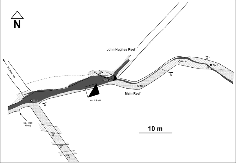
Clogau Main reef geological map from a section of the Ty'n-y-Cornel level at the No. 1 shaft. The reef shows pinch and swell, ESE linking segments and splits into the John Hughes reef. Gross reef trend is NE–SW. The John Hughes reef was extensively stoped for gold [Dark grey: quartz reef; stipple: Clogau Formation; hatching: greenstone]
At least five sub-parallel faults occur in the vicinity of No. 1 shaft (Figs. 9 and 10). Figure 10 shows two fault-controlled segments of the Main reef. The on-strike projections of reef and fault from Figs. 10 and 11A, are also likely to pass through the SE part of Fig. 9. The John Hughes reef is also parallel to a fault. Pre- and post-reef displacements can be recognised at some sites. Cumulative downthrows across these faults may account for the continued presence of black shale in the NE parts of the Llechfraith level.
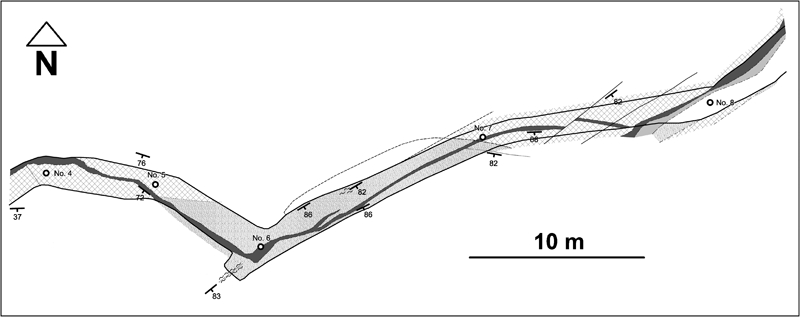
Clogau Main reef geological map from a section of the Ty'n-y-Cornel level, 30 m NE of the No. 1 shaft. The reef shows pinch and swell structure, a sharp, potentially fault and greenstone-controlled change in strike and minor fault offsetting. Gross reef trend is NE–SW [Dark grey/black: quartz reef; light grey: Clogau stone dyke; stipple: Clogau Formation; hatching: greenstone]
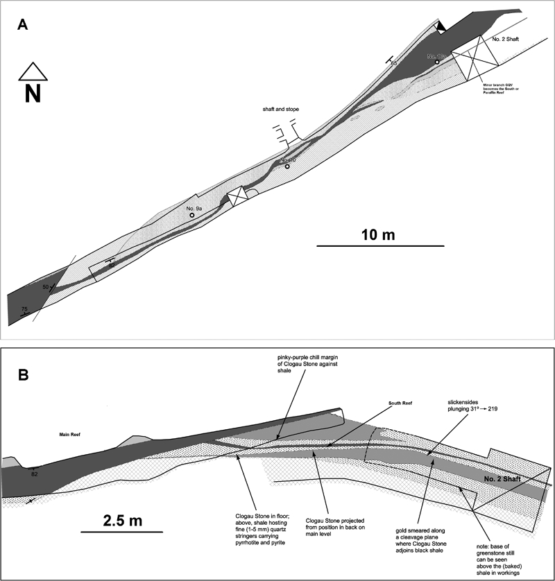
(A) Clogau Main reef geological map from a section of the Ty'n-y-Cornel level close to No. 2 shaft (see Fig. 6). The reef splits (east facing) into a minor branch. Beyond the No. 2 shaft this branch ultimately becomes the major South reef. (B) Detail of the split section of the Main-South reef with local occurrence of high-gold grades in sub-level 4 m below Ty'n-y-Cornel level. Gross reef trend NE–SW [Dark grey: quartz reef; light grey: Clogau stone dyke; stipple: Clogau Formation; hatching: greenstone]
Intrusives
Greenstone sills
Greenstone sills occur in the Clogau Formation ( Figure 3 Figure 4 Figs. 3, 4 and 8). Only the highest and thickest (∼40 m) greenstone (No. 3) near the top of the Clogau is shown in Figs. 3 and 4. This sill is traceable for 2 km. In the NE, it lies S of the reef outcrop but the greenstone outcrop descends in elevation to the SW and is seen in the mine near the Llechfraith portal. Maps show local offset and pod-like forms and indicate that the sill has a complex three-dimensional (3D) geometry.
Sills intersect the main workings on both Llechfraith and Cornel levels. These are thinner (<10 m, locally <1 m), less continuous laterally and at lower stratigraphic levels than the No. 3 sill (Fig. 8). Surface exposure indicates that these may change strike and thickness over short distances. Sills show fault offsets across the reef in both main levels.
Minor intrusives
A NE–SW trending dyke set, the Clogau Stone dykes are traceable through the mine. They run parallel to some reef segments and locally cut reef material (Figs. 7d, 10–12). They cause local dilution of the reef and control the walls of some stopes. The dyke is of intermediate composition and is clearly different compositionally from the greenstone sills and the NW–SE dykes. Two members of the NW–SE dolerite dyke swarm occur at the NE end of the St David's workings. The projected dyke trends intersect the reef, but there is no surface exposure to allow time relations to be established.
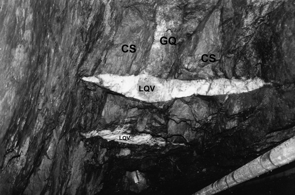
Photograph of typical relations among lenticular late-quartz veins (LQV), gold-quartz veins (GQ) and Clogau stone (CS) on the Llechfraith level. Two stacked late-quartz veins cut two thin Clogau stone dykes emplaced either side of the gold-quartz vein. Sub-horizontal traces of this feature can be traced towards the observer on both hanging wall and footwall showing that the two late-quartz veins have horizontal true dip and the SSE-inclined late-quartz veins is also showing its true dip. View looking SW
Late quartz veins
The Acadian gently dipping late quartz veins are well developed at Clogau and dissect the gold-quartz reefs and Clogau dykes (Figs. 7a, 7b and 12). Late-quartz veins are lenticular in three dimensions, tapering and vanishing up and down dip and across their strike. Late-quartz vein dimensions vary considerably, veins ranging from 1 cm to 8 m in length and from 1 mm to 1 m thick (Figs. 7 and 12). The NNW–SSE dimension is essentially controlled by the host gold-quartz vein width. Late-quartz veins comprise fibre and bucky textured white quartz with minor carbonate, chlorite and pyrite. They are gently inclined to the NE and are gold barren, effectively diluting the gold-quartz veins.
Summary
The reef cuts an earlier greenstone sill down-throwing it to the S (Fig. 14), comprises early-quartz and gold-quartz veins, and is cross-cut by a Clogau dyke and late-quartz veins.
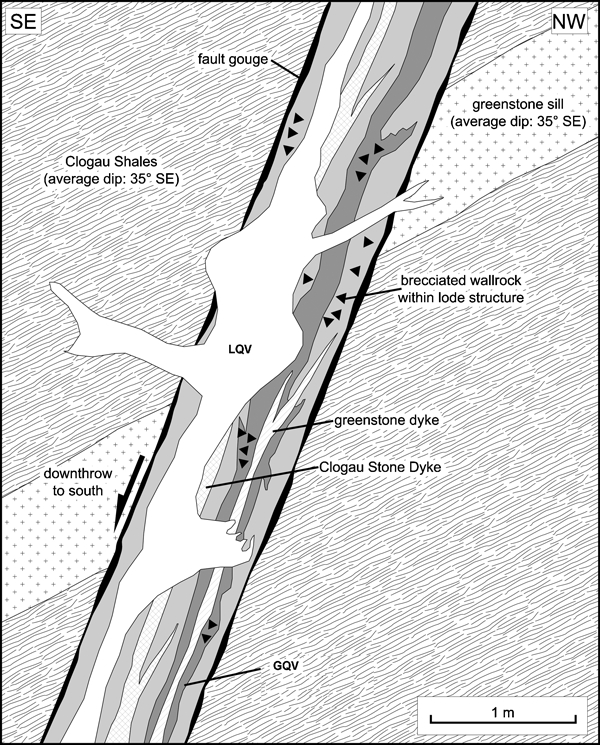
Idealised section through a Clogau gold reef showing general relationships between the various geological elements [LQV: late-quartz veins; GQV: gold-quartz veins] (modified from unpublished material of Clogau Gold Mines PLC)
Clogau Main reef
Reef structure
The Main reef can be traced for about 3 km, striking approximately NE–SW and dipping steeply 60 to 90°SE (Figs. 5 and 8). In detail, the reef commonly follows the faults, showing planar form with consistent strike for up to 200 m (Fig. 5). Locally it shows irregular, short-term changes in strike.
The Llechfraith level shows abrupt changes from NNE through to E at the portal and where it breaks into the fault hanging wall at Grandfather's stope (Fig. 5). The Ty'n-y-Cornel level shows E–W trending segments stepping between the main faults (Figs. 5, 9 and 10). A short segment of the eastern part of the St David's reef trends NNE in surface exposure, a similar trend to the John Hughes reef. Locally two parallel reefs are present, e.g. in vicinity of No. 1 shaft on both Ty'n-y-cornel and Llechfraith levels. Branches are also developed, for example on the Llechfraith level near the portal and on the Cornel level at the John Hughes and South reefs (Figs. 6, 7c, 9 and 11).
Significant dip variation is not common. Very low dips (<45°) have been observed at two sites: (i) Cornel drive back at the junction with John Hughes reef, and (ii) top of Grandfathers stope on Llechfraith level. It is not clear if these low dips are primary features or the results of later folding or fault drag.
The reef thickness can be uniform for 10 m or more (Fig. 7b and d shows shorter segments), but pinch and swell is quite common (Figs. 9 –11). Overall width ranges from 6 m down to a few centimetres and in places reduces to discontinuous veins and blobs in brecciated slate zones. It is commonly less than the modern minimum mining width of 1·2 m. Wide reef sections commonly include significant thicknesses of intercalated wall rock. Total reef width is also increased by later emplacement of the Clogau dyke at some sites.
Small-scale reef structure and composition
The reefs are assemblages of parallel or sub-parallel quartz veins with individual veins (e.g. gold-quartz veins) commonly ranging from 1 mm to 0·3 m in thickness (Fig. 7). The thickest single vein recorded by the authors reaches 1·6 m in surface exposure of the St David's reef.
Component veins are either in direct contact or separated by millimetre scale sheets of mudstone wall rock (Fig. 7). This situation results in a compact reef structure with cumulative vein thickness much greater than cumulative screen thickness, internal wall rock dilution is limited. Small numbers of veins separated by up to 10 cm of wall rock occur outside the compact reef (e.g. both sides of the Main reef in Fig. 7c and the hanging-wall side of the Main reef in Fig. 7d). The reef margin is then less well defined and testing the gold content of outlying veins is needed. It is noted that some wide stopes on the Cornel level may record extraction of rock carrying wide-spaced veins. In few cases, the reef shows most component veins separated by 1 cm or more of wall rock.
Surface staining of underground exposure makes it difficult to determine the lateral extent of individual veins. Individual vein terminations and narrow veins can be traced for up to 2 m (Fig. 7).
The ribbon veining with thin wall-rock screens shows that the reefs result from multiple dilation events reactivating the host fissure system. Where wall rock screens pinch out, textural changes in the quartz may mark the continuation of vein contacts (Platten and Dominy, 2009). Rare examples of quartz textures overgrowing screen ends may indicate near synchronous opening of some adjacent veins.
The existence of multiple veins in the Clogau reefs is well known (Fig. 7). At least seven well-defined veins and at least 10 veins can be distinguished in Fig. 7a and 7c respectively. Close-up examination of these sites may well demonstrate significantly more component events. Up to 20 component veins are reported from reefs elsewhere in the gold-belt (Platten and Dominy, 2009).
The main reef assemblage can be summarised as (Shepherd and Bottrell, 1993):
early non-auriferous quartz carbonate veins
main gold-quartz veins (the gold-quartz veins)
late barren quartz veins (the late-quartz veins).
The early-quartz and gold-quartz veins are now recognised as pre-Acadian, and the late-quartz veins as syn-Acadian segregation veins (Platten and Dominy, 1999).
Vein mineral assemblages
Reefs are arrays of 10 to 20 parallel to sub-parallel quartz veins. The lack of cross-cutting relationships means that the order of emplacement of individual veins is unknown. Repeated reactivation of the fracture system and consequent repeated episodes of hydrothermal flow and quartz infill are inferred. Although wall rock screens are common, randomly oriented wall rock clasts are an uncommon part of the vein fill.
The vein in-fills are dominated by quartz throughout the Clogau system. Quartz in hand specimen appears to retain primary textures, but thin sections show deformation and recrystallisation attributable to the Acadian events. Hand specimens show that quartz grain size decreases with decreasing vein width. Quartz texture varies showing columnar, equidimensional and indeterminate quartz grain shapes. Columnar quartz may show fans around the ends of wall rock screens. Small voids lined with inwards pointing, clear quartz euhedra occur within these veins. Fractures, as parallel arrays and networks locally obscure primary textures. Narrow (<1 cm) veins show comb quartz, quartz spanning vein width and randomly oriented quartz. Undulating and indented mudstone screens indicate pressure solution and modification of quartz.
Vein quartz shows variation in colour, which to some extent provides an indication of grade potential. Where quartz is pure white, as in the late-quartz veins, it is generally non-gold bearing and may contain trace quantities of pyrite and/or pyrrhotite. Elsewhere, quartz may be off-white to blue-grey (e.g. gold-quartz veins) which is considered to represent quantities of included sulphides and/or wall rock. The presence of included sulphides and wall rock in gold-quartz veins has been demonstrated at Gwynfynydd through thin section petrography (Dominy, unpublished data). Blue–grey quartz is often a good indicator of high gold grades (Shepherd and Bottrell, 1993). Observations by the current authors indicate that whilst this can be true, it is not always the case and gold-bearing quartz may be off-white rather than blue–grey. It is certainly true that gold is very rarely associated with pure white quartz.
Calcite is locally present with quartz in some of the Clogau veins (Bottrell and Spiro, 1988; Shepherd and Bottrell, 1993). It is seen in some blocks of reef material in the tip from the St David's lower level. The tip blocks, which do not have gold, show coarse (1 to 10 cm) blocky calcite locally growing on a substrate of quartz prisms. The calcite is deformed, locally granulated by shear and cut by fibre textured late-quartz veins. Visible gold has been observed in minor association with calcite in some recent high-grade ore.
Sulphide abundance varies between individual veins and laterally along them (e.g. Main versus John Hughes reef). In polished section, sulphides are texturally complex showing cataclasis, recrystallisation, replacement and exsolution phenomena (Naden, 1988; Shepherd and Bottrell, 1993; Mason et al., 2002).
Polished section studies show that three main assemblages of opaque minerals accompany quartz in the veins at Clogau (Bottrell and Spiro, 1988; Shepherd and Bottrell, 1993; Mason et al., 2002). These authors give slightly different versions of the details of the Clogau paragenetic sequence, but all give the following sequence which accords with the observations of the current authors:
early pyrrhotite-pyrite-arsenopyrite-cobaltite (in early-quartz veins)
telluride-gold-galena (in gold-quartz veins)
chalcopyrite-pyrrhotite (cuts gold-quartz veins).
The gold-telluride (e.g. gold-quartz veins) mineralisation forms two assemblages (Naden, 1988):
a tellurbismuth-dominated assemblage, comprising tellurbismuth with minor tetradymite, galena, hessite, altaite and gold
a galena-dominated assemblage, with major galena and minor tetradymite, wehrlite, hessite, native bismuth, bismuthinite and gold.
Observation of high-grade samples and stope exposure by the authors confirms the two assemblages. Recent mining in the Llechfraith section revealed gold associated with the tellurbismuth-dominated assemblage, and around the No. 1 and No. 2/No. 5 shafts the galena-dominated assemblage was observed (locations given in Fig. 6). The inter-relationship, relative abundance and spatial distribution of the two assemblages is unknown.
Gold occurrence
The majority of the gold occurs as free particles in quartz, with some gold intergrown with sulphides or tellurides. Similar material may have existed in the South reef as Hall (1975) notes reports of extremely rich parts, which were ‘…so rich in gold as to be simply quartz held together by gold’. As previously noted, gold is seen to occur in close spatial association with bismuth sulphides and tellurides, and sometimes galena (Huddart, 1904; Gilbey, 1968; Naden, 1988; Shepherd and Bottrell, 1993; Mason et al., 2002). Gold tellurides are not observed. The gold-telluride mineralisation invades fractures in the quartz and partially replaces the early sulphide phase (Naden, 1988).
Gold generally has fineness above 800 (<20% Ag in gold). Historically large masses of gold on the 10s cm scale have been reported (Hall, 1975, 1988). Within high-grade pockets over 75% of the gold reports to the +300 μm fraction and over 85% to the +150 μm fraction, and less than 5% reports to the −50 μm fraction (Dominy et al., 2000). High-grade zones (>30 g/t Au) are generally dominated by very coarse-visible gold greater than 500 μm and up to a few millimetres in size. Low-grade background material (<8 g/t Au) is known to exist within and proximal to ore shoots, and is dominated by coarse gold below 300 μm in size.
Mineralisation appears, at least locally, to be related to specific events which controlled the distribution of gold and its associated minerals. For example, the John Hughes reef trends about 30° to the gross trend of the Main reef, but is parallel to some local segments in the Main reef ( Figure 5 Figs. 5 and 9). The Main reef gold is associated with tellurides, whereas in the John Hughes reef gold was related to galena and minor tellurides. This mineralogical difference must indicate that the Main reef was inactive at the time of John Hughes reef activity. This is supported by field evidence based on the fact that the widest part of the John Hughes reef (approximately 1 m) is parallel to the thinnest sparsely-mineralised part of the Main reef. Beyond this 50 m long section, the John Hughes reef thins to the E and W, where the Main reef regains its width of between 0·5 and 2 m. Time relations between the John Hughes and Main reefs are unknown.
Geological history and timing
Mineralising fluids and source rocks
Clogau has been the source of much of the data on fluid inclusions, stable isotopes and mineralising fluids used to interpret the origins and evolution of the gold-belt reefs (Bottrell, 1986; Bottrell and Miller, 1990; Bottrell and Spiro, 1988; Bottrell et al., 1988; Bottrell et al., 1990; Brand et al., 1989; Naden, 1988; Shepherd and Bottrell, 1993; Shepherd et al., 1991). The reefs were shown to be emplaced at ∼300°C and 1·8 kbar, whereas the alpine-type late-quartz veins and metamorphism took place at up to 365°C and 3 kbar. The source region was inferred to be the buried Bryn-Teg Volcanic Formation present at depth in the Harlech dome (Table 1; Allen and Jackson, 1985a). Gold deposition was shown to be controlled by reaction with graphite in the Clogau Formation (Table 1). The late-quartz veins were actually recognised as being of local origin and post-dating the gold-quartz veins (Bottrell et al., 1990). At this time, the reefs were considered to be later than the Acadian cleavage and the reef mineralisation was thus discussed in the then accepted context of post-orogenic mineralisation.
Geological development at Clogau
Recent studies have determined the general sequence of geological events within the Dolgellau gold-belt, most of which are observed at Clogau (Platten and Dominy, 1999):
deposition of Cambrian host sediments
emplacement of greenstone sills
normal faulting on ENE to WSW trends
ribbon vein emplacement along fault planes forming early-quartz veins and gold-quartz veins
emplacement of Clogau stone dyke element of NE–SW dyke swarm
fracture of gold-quartz veins and dykes with initiation of formation of late-quartz veins. E-dipping late-quartz veins first, W-dipping veins second (rare at Clogau). Cataclastic internal deformation of the gold-quartz veins. Onset of main metamorphic stage
continued deformation, producing cleavage and deforming all pre-existing rocks. Metamorphic recrystallisation generates strain-free quartz in the gold-quartz veins
post-cleavage, post late-quartz vein events such as the calcite-marcasite veins (not seen at Clogau) and the regional N–S faults (e.g. Bryntyrion fault).
The possibility of multiple movement events on the ENE–WSW (event ii) and N–S (event viii) faults requires further investigation at Clogau.
Age of mineralisation
A precise age for the mineralisation is still difficult to establish. The demonstration of a pre-Acadian age for reef emplacement shows that the existing K-Ar ages (average 405±6 Ma) for reef sericite record peak Acadian metamorphic events (events vi and vii), rather than reef emplacement (Platten and Dominy, 1999; Mason et al., 2002). The greenstone sills (event ii) belong to the Ordovician volcanic episode showing that reefs post-date the late Tremadocian (479–488 Ma) onset of volcanism. The post-reef Clogau dykes (event v) may be part of the Ordovician volcanic episode or outlying representatives of Silurian or early Devonian volcanic activity elsewhere in the British Isles.
The local presence of both pre- and post-reef igneous intrusions at Clogau offers the possibility of using U–Pb single zircon isotope dates to bracket the time of emplacement of the reef system.
Ore controls
Two principal controls to gold mineralisation and ore shoot formation have been identified at Clogau: lithogeochemical and structural. The lithogeochemical control relates to the interaction between gold-bearing fluids and the Clogau Formation. The structural controls combine the effects of reef-hosting fracture refraction by greenstone sills, reef splitting and potentially cross-faults.
Lithogeochemical
Gold mineralisation is exclusively contained within the quartz reefs where they are hosted within dark graphitic shales that carry pyrite and pyrrhotite. The main host is the Clogau Formation, but some dark shale occurs within the uppermost Gamlan and basal Maentwrog Formations. This gives a total prospective mine sequence thickness of approximately 200 m (Table 1 and Fig. 8).
This control has been shown to be related to the interaction between the carbonaceous shales and gold-bearing fluids. A fluid-inclusion study on gold-quartz vein material indicates the presence of methane, where reduction of the hydrothermal fluids by methane is considered to be the main gold-precipitation mechanism (Shepherd et al., 1991; Bottrell et al., 1988; Bottrell and Spiro, 1988).
Greenstone sills
A critical control to ore shoot localisation at Clogau is related to the mechanical effects of the greenstone sills on the reef – a feature common across the Dolgellau gold-belt (Hall, 1975, 1988; Dominy et al., 1996; Dominy, 2012). The sills were intruded into the Clogau Formation before reef formation. They are competent intrusive rocks locally up to 50 m in thickness and fracture differently to the enclosing shales (Fig. 8). The sills are offset across the plane of the reef with an apparent down-throw to the SE (Figs. 13 and 14). The sill/reef intersection pitches at a low to moderate angle SW on the vein. Mapping shows that the reef-hosting fractures are sometimes refracted when they reach a sill.
(A) Main and (B) John Hughes reefs at Clogau. The gross ore shoots are located at the base of the greenstone sills cut by the reef structures. Dots represent approximate locations of high-grade pockets (or sub-shoots) located within the gross shoots based on historical long-sections. The dots do not imply pocket size, only location and spatial distribution (modified and redrawn from unpublished material of Clogau Gold Mines PLC)
Twenty to 45° SW-plunging ore shoots bearing high-grade pockets are spatially associated with sill intersections (Figs. 6 and 13). They lie below the sill intersection on the NW side of the structure, but extend across the truncated surface of the sill intersection on the SE wall (the gross hangingwall). This may indicate flow localisation related to local widening and closure of fractures as a result of a competency contrast between greenstone and shale as well as refraction.
The presence of gold mineralisation below greenstone sills is apparent in the John Hughes reef (Fig. 13b). However, an important conclusion from recent studies is that this control was regarded by earlier miners as the most important and has guided mining of the shallow plunging ore shoots. The old stopes pitch at about the same angle as the bedding against the plane of the reef and occur where the greenstone sills can be projected onto the workings. It appears that as well as at John Hughes, most of the early workings at Clogau were related to intersections of the reefs with the greenstone sills (Fig. 13a).
Reef splitting
Splits (or branches) along the reefs have long been known to carry gold mineralisation (Figs. 6, 9, 11 and 15). Splits provide steep-pitching conduits for ascending mineralising fluids, resulting in 45 to 80° pitching ore shoots along the axes of the splits. Due to the variable nature of gold-quartz reefs dip and the pitch direction of the split axis at different localities, NE- and SW-facing splits with different pitch axes exhibit different styles of mineralisation.
(a) NE–SW vertical longitudinal projection of the Main reef Llechfraith section and position of three ore shoots related to reef branching and/or greenstones. High-grade gold mineralisation was located between the No. 3 and No. 4 sub-levels on the No. 1 shoot. The shoots have steep (70°SE) plunge down dip in the reef, but pitch SW in the plane of the reef. The greenstones pitch 30–40°SW in this section. (b) A geological plan along the Llechfraith level in (a) above. No. 1 shoot relates to a reef split [C]; No. 2 shoot a bend in the reef and possible effect of a greenstone body [B]; and No. 3 shoot relates to a local split-loop in the reef and associated greenstone body [A]. Llechfraith section located at the SW end of the Llechfraith level, see Fig. 5 (modified and redrawn from unpublished material of Clogau Gold Mines PLC)
The geometry of mineralised splits is more closely established by recent mining in the Llechfraith level. Activities during 1984 to 1987 followed the Llechfraith No. 1 shoot down-dip (Fig. 15). The shoot plunges 65°SW, is approximately 10 m along strike and can be traced 40 m down-dip from surface to the No. 4 level below. The shoot is related to a split in the reef with high-grades within the hinge zone. At this split the reefs diverge to the SW in plan and diverge upwards in cross section. Two further parallel shoots were established, with No. 3 shoot related to a loop-shaped split in the reef and No. 2 shoot related to a bend in the reef (Fig. 15).
The reef splits are not uniformly mineralised. Historical records suggest that in E-facing splits the mineralisation was in the minor vein away from the split, whereas in W-facing splits it was in the main vein near to the split (hinge) zone (Fig. 9; the split ‘V’ s facing, i.e. widening E). This situation is likely to reflect a sinistral couple acting on the branch faults and the system acting in tension to form dilational zones that host mineralisation.
Recent studies have shown that the situation is not simple. Open space development is important for split-based mineralisation to occur and two favourable sites are indicated: W-facing split with a W-pitching junction and E-facing split with an E-pitching junction. Other configurations result in good open space development on the Main reef rather than on the branches which are generally poorly mineralised. Splits can be complex and may change plunge with depth or close and disappear.
Grade distribution
Scale of ore-bearing features
Gold is erratically distributed within the ore shoots. Very high-grade visible gold patches may lie within 10s cm of low-grade (<0·1 g/t Au) quartz. In general, the extreme high-grade areas are only continuous over very small areas.
The critical problem at Clogau and in all Dolgellau mines, is to locate the small, but rich gold pockets. There is a decreasing scale of global continuity for these features, ranging from:
Quartz reef (1 to 3 km along strike by 300 m down dip) hosted in the Clogau Formation
Main ore shoot (<200 m down plunge by <50 m across plunge) within the quartz reef; to
Sub-shoot or pocket (<5 m2) in the main ore shoot.
Establishing reef location is less challenging based on surface exposure and mapping, though locally they may show strong discontinuity (Dominy and Platten, 2008; Platten and Dominy, 2009). The identification challenge heightens for the main ore shoot and becomes severe for sub-shoots/pockets (Platten and Dominy, 2003; Dominy et al., 2003; Dominy and Platten, 2008).
A vertical longitudinal projection along the Main reef, from No. 1 shaft into the St David's workings is provided (Fig. 6). The Clogau section is extensively stoped. Selective mining and processing up to 1899 yielded a recovered grade of 55 g/t Au (estimated mill head grade of between 70 and 80 g/t Au). These stope outlines likely indicate dominantly high-grade sub-shoot locations or clusters thereof. Bulk mining and processing during 1900–1911 yielded a recovered grade of 12 g/t Au (estimated mill head grade of between 15 and 17 g/t Au). High-grade pockets were known to have been extracted during the bulk mining phase, with general locations given in Fig. 13a.
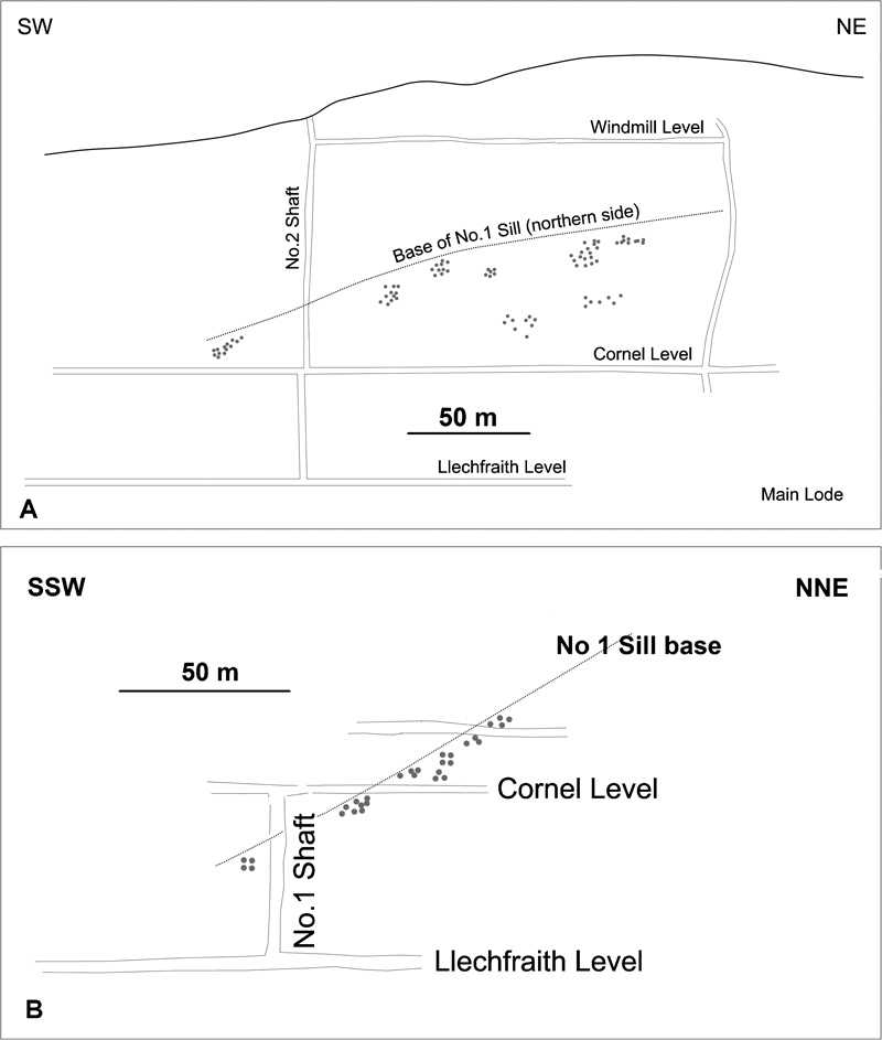
The area around the No. 1 sill/reef intersection (base No. 1 sill on Figure 6 Figs. 6 and 13a) was extensively stoped during the main working period, and included high-grade shoots ([4] and [5] – Fig. 6). Stoping on the upper part of No. 5 shaft is likely to be related to the Main-South reef split ([1] – Fig. 6). The control on shoots [2] and [3] is unknown, but may be related to minor branching (Fig. 6). Shoot [5] plunges approximately 175 m SW, whereas the other shoots are restricted to 50 to 80 m gross plunges.
Stoping around No. 1 shaft represents the hinge of the Main and John Hughes reefs, with stoping on the Main reef (Fig. 6). Shoots on the John Hughes reef beyond the split relate to the No. 1 sill (Fig. 13b).
Controls on shoots within the St David's workings are not proven, but it is known that the No. 1 sill passes through the workings in a similar manner as to the Clogau workings.
Rich-pocket occurrences
There are two sites at Clogau where there is some indication of the shape and dimensions of gold-rich pockets in the nineteenth century accounts (Hall, 1975; 1988).
The reopening of the St David's discovery site in 1859 is well-documented and produced around 0·8 t quartz with abundant gold (Hall, 1975). The reef was 0·75 to 0·9 m wide. A ‘rib’ of calcareous material 5 to 10 cm thick in the reef carried abundant visible gold for 5 to 8 cm. The ‘rib’ is likely to represent a single component vein in the ribbon veined reef. A second patch, 0·3 m high and 8 to 10 cm wide, was abundantly impregnated with minute particles of fine yellow gold. This elongate patch may also represent a single vein, but it is not known if it is the same vein as the first patch.
At the junction between the South and Main reefs in the Clogau No. 2/No. 5 shaft (Fig. 6), a 1·8 m long by 1·4 m high by 0·23 m thick mass of quartz produced 16 kg Au in 1867 (Hall, 1975). The plate-like form and dimensions suggest that this represents a segment of one of the thicker component veins in the reef.
Gold pockets are reported at other sites, but although relatively well-located in the plane of the reef (on old long-sections), are poorly located with regards to geological context and it is not known if they occupy a single component vein or a group of veins. The original discovery site is typical. The initial discovery at St David's from material in the mine office involved ‘…large blocks of some hundredweights. …showing gold all over, beautifully disseminated…’. (Calvert, 1854).
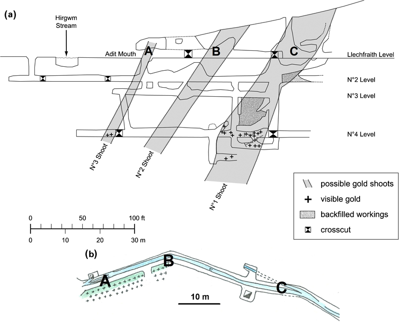
During the mid-1980s, stoping in the Llechfraith section yielded a number of small gold pockets within the No. 1 shoot (Fig. 15). Exposure seen by one of the authors (SD) on the No. 4 level, comprised a zone of about 1·5 m strike length and 0·5 m width on the hangingwall of the 2·5 m wide reef structure. Abundant visible gold associated with tellurides was hosted within Clogau shale interleaved with thin blue–grey quartz veins. Gold was observed within both quartz and shale, and in some cases seen along slickensides within the shale.
Activity during the 1990s included locations at the No. 1 and No. 2/No. 5 shafts on the Ty'n-y-Cornel level (Figs. 6 and 11). Rich-gold mineralisation occurred in narrow zones of more than a few square metres in area. At No. 1 shaft, a 10 to 20 cm laminated vein associated with the Main-John Hughes reef split and the No. 1 sill was followed upwards via a raise, and encountered visible gold associated with galena. On the SW edge of the No. 2/No. 5 shaft, a narrow vein associated with the Main-South reef split (Fig. 11b) hosted visible gold. The occurrence was located off the minor split vein and distributed along a 1·5 m zone of cleaved shale.
Analysis of production grades
The average mill recovered grade at Clogau was around 17 g/t Au and the estimated head grade of around 21 to 24 g/t Au, though these figures are misleading given they reflect a mix of selective versus non-selective mining approaches. Historical and recent mining indicates that selective stoping of shoots to maximise gold pocket extraction is likely to yield diluted grades of between 60 and 150 g/t Au (3–5 oz/t Au). The ore shoots have a moderate gross continuity (10s m down plunge and <25 m along strike) once identified, but the gross bonanza pockets are less easy to determine without mining as they tend to be on a scale of <5 m – this feature is typical of all Dolgellau mines (Platten and Dominy, 2003).
Relatively little is known about the historically mined low and background-gold grades at Clogau. This applies to sites between the stoped shoots and local unstoped areas within the shoots themselves. Bulk mining during 1900 to 1911 produced mill recovered grades of between 2·3 and 8 g/t Au, with a mean of 6·5 g/t Au (Fig. 6). Channel samples taken in the 1980s and 1990s indicated grades between 0·01 and 30 g/t Au, with many (80%) below 5 g/t Au. Stoping in the 1990s close to No. 1 shaft, yielded small ore parcels with mill recovered grades in the 1 to 9 g/t Au range. Low-grade material within the Llechfraith section No. 1 shoot was identified on the No. 2 sub-level (Fig. 15). A 250 kg sample collected from the level backs in 1995 was processed in a laboratory pilot plant yielding a head grade of 7·3 g/t Au; minor visible gold was observed. Dominy and Minnitt (2012) confirms the presence of coarse gold in low-grade ore.
Historical stoping records show that ore shoots contained gold-rich pockets in approximately 10 to 15% of the total shoot area. At 10% of shoot as high-grade pockets, this gives a potential grade of 140 g/t Au (4·5 oz/t Au) based on 70% of gold inventory in the pockets. For the low-grade mineralisation, a grade of 8 g/t Au was used based on low-grade bulk stoping during 1900–1911. At 15% high-grade pockets, this gives a grade of 95 g/t Au (3 oz/t Au) based on 70% of the gold inventory in the pockets. Grades quoted are based on a mill estimated head grade of 21 g/t Au (i.e. corrected for a nominal 20% mill loss).
This analysis indicates the highly localised and extreme grade nature of the Clogau mineralisation (Dominy, 2011, 2012). Eighty per cent of the gold inventory at Gwynfynydd was also located in pockets that graded around 90 g/t Au (3 oz/t Au; Platten and Dominy, 2003).
Application to potential mine development
Geological factors
This review allows the identification of factors relevant to potential exploration and ore shoot evaluation at Clogau. The historical stopes show that ore shoots are associated with:
host rocks of graphitic and pyritic mudstones, primarily Clogau Formation
reef intersections with greenstone sills
reef branches
and that gold in the ore shoots is characterised by:
coarse (visible) grain size
association with tellurides and/or galena
small, very high grade pockets.
Questions remain, particularly as exploration moves away from the main areas of existing stoping. The host rocks require:
refined understanding of distribution of black mudstones in the local stratigraphy, particularly in Llechfraith level (Fig. 8)
determination of displacements on ENE–WSW faults and refining of fault timing relative to sill and reef emplacement (Llechfraith level in Fig. 8)
determine distribution of sills (Fig. 8)
determine the 3D form of the greenstone sills taking note of recent developments in understanding sill morphology (Schofield et al., 2012a, 2012b)
further investigation on the role of the N–S anticline on reef form.
The reefs require investigation of:
gold distribution in relation to individual veins in the reef
continuity of these individual gold-bearing veins
associated mineralogy in individual gold-bearing veins in the reef
characteristics of gold distribution at splits, particularly structure related to individual veins and the enclosed wall-rock wedge
causes of the difference in size of the shoots located in the nineteenth century and shoots mined subsequently.
Risk and resources at Clogau
Unexplored areas at Clogau occur in the mine above and below much of the Llechfraith level and above Ty'n-y-Cornel level SW of main cross-cut (Figs. 5 and 6). Other areas are on-strike continuation SW of River Hirgwm and sub-parallel reefs to the SE, including Old Clogau and Vigra (Figs. 3 and 8; Dominy 2011; 2012).
The critical problem is to locate the small, but rich, gold pockets within the remaining un-worked areas of reef. There is a decreasing scale of continuity of these features:
quartz reef hosted in the Clogau Formation
main ore shoot within the quartz reef
sub-shoot or pocket in the main ore shoot.
Establishing reef location at Clogau is the least challenging, based on mapping of surface and underground exposure. Complications result from branching and discontinuities resulting from primary features and later faulting occur. The identification challenge heightens for the main ore shoots and becomes severe for sub-shoots/pockets.
The descriptions of gold grade here, although useful show that there is no systematic set of spatially located data on grade, thickness and reef character. There is therefore no background data to support new exploration data and modern digital grade models of the system.
There are currently no resources or reserves defined at Clogau. This lack of resources is related to the need for very close-spaced diamond drilling (e.g. <5 m by 5 m) and/or underground development to resolve the pocket-like nature of mineralisation. Mineralisation at Clogau is true drill for structure and drive for grade type. Diamond drilling will critically resolve 3D structure and stratigraphy. Drilling aims to identify certain geological features, such as stratigraphy, presence of greenstone bodies, quartz reefs, mineralogy and texture oriented in 3D space that can be used to evaluate potential target zones.
Further ore shoot evaluation and potential exploitation at Clogau requires the management of risks that include:
the assumption that reefs and/or ore shoots continue at depth and/or along strike based on historically-based geological models
the risk that a reef will not have the contained metal in ore shoots with the shapes, sizes, grades and distributions expected
the boundaries and internal gold grade distribution of the ore shoots not being correctly assigned ahead of mining, resulting in either or both excessive dilution or misclassification of ore as waste.
On-going resolution of the controls on ore shoot and sub-shoot formation is required to manage these risks. There is still much work to undertake at Clogau to resolve the genesis of the high-grade pockets. This study has revealed a number of key ore controlling factors, providing a base for further mine exploration.
Footnotes
Acknowledgements
Gold-belt studies by the authors have benefitted from interactions with Clogau Gold Mines PLC, Clogau St David's Gold Mines Ltd, Welsh Gold PLC, Stoic Mining and Exploration Ltd and New Union Mining Ltd. Recent activity at Clogau has been via Stellar Resources PLC subsidiary, Gold Mines of Wales Ltd. Work during the 1980s by David Pelham and the late Dr John Rottenbury of Clogau Gold Mines PLC is acknowledged. George Hall (New Union Mining Ltd) is thanked for discussions and the provision of historical data. Thanks are due to two AES reviewers and Editor, Professor Neil Phillips for their helpful comments on the manuscript. The opinions expressed in this paper are those solely of the authors. An early version of this paper was presented at The AusIMM Narrow Vein Mining Conference 2012.