
Abstract
The Late Devonian Strathbogie batholith is a 1500 km2, semi-contiguous mass of undeformed, peraluminous monzogranite and syenogranite in SE Australia. The rocks are S-type and contain abundant igneous cordierite. Internal variations within the batholith have been investigated here by systematic fieldwork guided by modern concepts of granite batholith structure, combined with geophysical and geomorphological data. Important field parameters include the outcrop character and abundance of tors and pavements, feldspar phenocryst size and abundance, groundmass grain size, the textures, grain sizes and abundances of quartz, cordierite, garnet and biotite, and the presence or absence of tourmaline, vugs and enclaves. Mapping has been supplemented with aeromagnetic data to define the external boundaries of this essentially non-magnetic batholith, but these data cannot be used to delineate internal structures. The K-Th-U distribution, from airborne radiometric surveys, was found to assist in sub-division of the batholith, and the digital elevation model formed the basis of an interpretation of batholith structure, including lineaments. Some parts of the batholith have quite distinctive field characteristics and are interpreted as discrete plutons (e.g. the Kerrisdale and Lightning Ridge plutons). Broad trends in feldspar phenocryst abundance and the presence of tourmaline and vugs (miarolitic cavities) indicate an upper contact (roof) of the batholith in the northwest. Cordierite is ubiquitous, most rocks contain a few percent of biotite, there is widespread accessory garnet, and tourmaline is present within the inferred near-roof zones. The field-based approach described here offers a method for mapping large batholiths without resorting to grid sampling and the accumulation of vast sets of whole-rock analyses. This field-based method is especially applicable in cases where there are no obvious pluton boundaries, such as internal wall-rock screens or contacts exposed on glacial pavements. The field approach records outcrop- and district-scale variations, and many textural and mineralogical features that would be omitted in any map based only on geochemistry.
Keywords
Introduction
Understanding a batholith requires knowledge of its overall character and its local and regional variability. The subdivision of some batholiths is based on mapping the metasedimentary screens that mark the intervals between the separate plutons, as for example in the Donegal batholith of western Eire (Pitcher and Hutton, 2003), the Sierra Nevada batholith of California (Bartley et al., 2012), and indeed in the composite Berridale and Kosciuszko batholiths (e.g. White et al., 1977). The challenge of subdivision is much greater if metasedimentary screens are absent (e.g. the Tuolumne suite, Glazner et al., 2004). In such cases, possible methods include an approach involving large-scale, whole-rock geochemical analysis, extensive and intensive thin-section petrography, or field-based mapping of variations within and among numerous outcrops. Although the geochemical and petrographic approaches minimise time in the field and provide semi-quantitative results, they both suffer from the limited spatial scale of sampling and poor resolution of spatial variations. Even if field mapping cannot fully account for outcrop-scale variations, it can at least be used to recognise and record such variations semi-quantitatively. Airborne and satellite-generated, remotely-sensed, K-Th-U radiometric, gravity, magnetic and hyperspectral data provide useful complementary information on regional patterns of variation. However, to date, the remotely-sensed data have not been applied to identify and understand outcrop-scale variability.
Use of a field-based approach requires an initial plan of what observations might be recorded and what such data might mean. For example, will the approach to mapping be based on recognition of different source areas for magmas, different emplacement and crystallisation processes, or different degrees of magma mixing, contamination and hybridisation? A further decision is how the field-based approach should be executed, and this will depend upon the size of the batholith, the amount of outcrop, degree of weathering, the terrain, infrastructure for access and land ownership. Tools based on modern navigation systems (i.e. GPS) and Geographical Information Systems (GIS) offer advantages compared to the era of the 19th and 20th centuries when field-based mapping of batholiths was more common; see for example the compilation of works in Roddick (1983), Cobbing (2000) and references therein.
The Strathbogie batholith is significant for several reasons, including its emplacement at very shallow levels in the Earth's crust immediately following eruption of the adjacent Violet Town Volcanics (White, 1954; Clemens and Wall, 1984; Elburg, 1996), and the widespread occurrence and abundance of magmatic cordierite (Phillips et al., 1981). The rocks of the batholith are also chemically very reduced, having lower Fe2O3/FeO than almost any other granitic rocks in the Tasman Fold Belt (White and Chappell, 1983, 1988). Additionally, a garnet-cordierite-bearing granite from the Strathbogie batholith was used in early crystallisation experiments to help understand the roles of different minerals and varying P-T-aH2O conditions in the formation of S-type magmas in general (Clemens and Wall, 1981). Note that here we use the IUGS classification when we give rock names based on the modal mineralogy and, when based on the chemistry, we use the classification scheme developed by Middlemost (1994).
The lack of any realistic picture of the internal variations within the Strathbogie batholith presents a challenge to furthering our understanding of this large granitic mass. The present work represents an investigation of the internal subdivisions of the Strathbogie batholith that also provides a test of mapping methods designed for use in intrusions that have only intermittent outcrop. The approach has been to use our understanding of granitic batholiths in general (e.g. Clemens, 2012 and references therein) to conceive of characteristics that reflect the magma source terrane that evidently lies deep within the Central Victorian crust. To these are added characteristics that reflect processes of emplacement and crystallisation of the Strathbogie magmas. An interpretation of structural lineaments is combined with several geophysical datasets to aid in identification and delineation of subtly different rock types (and potentially different magma compositions). Structural readings and detailed outcrop observations, collected at numerous field localities, provide an overview of the mineralogical and textural variations, and hence some indication of the magma crystallisation processes. Future work will generate a higher density of field observations and some more detailed mapping across critical contact areas. On-going related studies include elemental and radiogenic isotope analyses, and petrogenetic and structural studies that will incorporate this new field-based batholith framework with work on the evolution of the Melbourne Zone and its granitic rocks in general, and also the relationships between the granitic rocks and gold mineralisation.
Regional setting of the Strathbogie batholith
The Tasman Fold Belt extends for 2000 km through eastern Australia and is over 500 km wide (Fig. 1). This Belt contains abundant plutonic rocks that intrude Palaeozoic metasedimentary sequences. Toward the southern end of the Belt, in the state of Victoria, granitic rocks comprise nearly 20% of the exposed Palaeozoic rock package, and felsic to intermediate volcanic rocks make up a further 5% (VandenBerg, 1997; VandenBerg et al., 2000; Birch, 2003; Fig. 1).
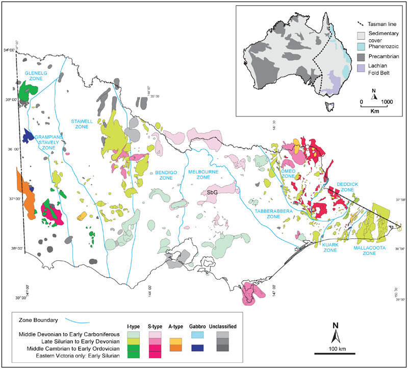
Map of Australia showing the Palaeozoic Tasman Fold Belt in eastern Australia with the Lachlan Fold Belt in the SE. Proterozoic rocks and Archaean cratons dominate in Central and Western Australia (inset). The southern part of the Lachlan Fold Belt (LFB), in the state of Victoria, is shown with the structural zones that have been used to subdivide the LFB, and the widespread granitic rocks of Silurian to Devonian ages. The Strathbogie batholith, in the central part of the Melbourne Zone, labelled SbG, is one of the largest granitic masses and trends E-W (VandenBerg et al., 2000)
Maps are provided of locations used in the following text; these include locations external to the batholith (Fig. 2A) and within the batholith (Fig. 2B). The locations also relate to sampling for future petrological work.
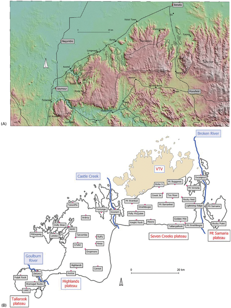
(A) Digital elevation model of the Strathbogie batholith and its surroundings. All the areas of granitic rock, the Violet Town Volcanics and the southern contact aureole are significantly elevated with respect to the Murray Basin to the north, and the Goulburn River valley to the south. Also shown are numerous towns outside the batholith, some of which are used as reference points in the text. (B) Map showing the geographical subdivision of the Strathbogie batholith into four main plateaux divided by three north-flowing river systems. There are small, poorly outcropping, metasedimentary blocks along the contact between the Violet Town Volcanics and the batholith. The line running between Warrenbayne and Paps appears to be an important geophysical boundary (see discussion in the text). The township of Strathbogie and various localities within the batholith are shown and used for reference in the text
The Strathbogie batholith is elongate in an east–west direction and strongly discordant with the dominantly north–south orientated structures in the Melbourne Zone Ordovician to Devonian metasedimentary rocks that border the batholith on its southern and on part of its northwestern margin (White, 1954; Hergt et al., 2002; VandenBerg et al., 2006). In these sectors, a broad thermal aureole of pelitic to psammopelitic hornfels surrounds the batholith, commonly producing an erosion-resistant ridge that rises above the surrounding plains. Much of the northern margin of the batholith is marked by the contact with the overlying Cainozoic sediments of the Murray Basin. The exception is in the northeast where the batholith intruded and contact metamorphosed Late Devonian felsic ignimbrites of the Violet Town Volcanics (Clemens and Wall, 1984; Elburg, 1996).
The contact between the batholith and Palaeozoic metasedimentary rocks is simple and rather linear on the southern margin. Here, progressing from east to west, there is a 40 km E–W section, a 90° bend toward the south, a 20 km N–S section and finally a 20 km E–W section. Where the contact has been mapped in the east, in terrain with 500 m of relief, its trace on the ground is compatible with the contact being close to vertical but with some small-scale 90° jogs, each of tens of metres in extent (Phillips et al., 2002). The nature of the granite–hornfels contact in the northwest, near Avenel, is quite different from the southern boundary. Here, instead of having a near-vertical orientation, the contact follows contours for several kilometres, indicating a near-horizontal roof and possibly a near-horizontal base to the batholith. This geometry implies that the batholith here is thin (100 s of metres maximum thickness) and wedge-shaped, intruding sub-horizontally into the folded Siluro-Devonian wall rocks. In the far SE, north of Bonnie Doon, Cambrian meta-igneous and metasedimentary rocks abut the batholith SE of Mt Strathbogie (i.e. the Glen Creek inlier) and similar Cambrian rocks occur immediately east of the Mt Samaria plateau. These rocks include metabasalts, metarhyolites and clastic metasedimentary rocks (VandenBerg et al., 2006). The Carboniferous red-bed sequence of the Mansfield Basin post-dates the batholith and overlaps it locally in the east (VandenBerg et al., 2000; Birch, 2003). The pre-Carboniferous metasedimentary rocks of Central Victoria are folded about NNW-trending axes except around the west and north of the Strathbogie batholith where the pattern is more complex and multiple folding episodes are inferred (Gray and Mortimer, 1996; Morand et al., 1997).
The Strathbogie batholith has been dated at 374±2 Ma using SHRIMP U-Pb analyses of zircons (Bierlein et al., 2001) making it early Late Devonian in age (given that the base of the Late Devonian lies at 385 Ma). Cainozoic alkali-basaltic lavas (mainly potassic melabasanites and nephelinites) are preserved in several exposures spread over 10 km and in a N–S alignment south of Euroa (Paul et al., 2005).
With respect to internal structure of the batholith, some variations were identified in previous studies. Examples are nominally equigranular and porphyritic types, a small hornblende-bearing I-type intrusion, and the Kerrisdale micro‘adamellite’, all recognised by Phillips et al. (1981). Despite the textural variations within the main batholith, it appeared to lack mappable internal units (at least at the spatial resolution of previous studies). Our work is now showing that the detail of that earlier mapping was inadequate to identify variants that have local or even district extent. In areas of more extensive outcrop, some textural parameters exhibit variations on the scale of hundreds of metres. In areas of poorer outcrop, the distances between outcrops greatly exceed the scales of known variations. Some years ago, the decision was taken to remap the batholith using the extensive road and track network together with a large number of field traverses. More recent concepts of how batholiths form and are emplaced (e.g. Clemens, 2012 and references therein) provided the basis for the decision to collect a wide range of geomorphological, mineralogical and textural data to complement parallel geochemical work and publicly-available geophysical surveys.
The Strathbogie batholith in the light of current ideas on the genesis of granitic magmas
Research over the past 30 years or so has revolutionised the way in which we view the phenomenon of granitic magmatism. Clemens (2012) summarised current knowledge and what follows here is a brief digest of some important points. We are now confident that the great majority of granitic rocks crystallised from magmas that were initially at relatively high-temperatures (800–1000°C) and were initially quite H2O-undersaturated (typically containing 2 to 5 wt-% of dissolved H2O) and evolved toward H2O-saturated conditions only late in their crystallisation histories. These granitic magmas were formed mostly by fluid-absent partial melting of a variety of crustal rock types during high-grade (mainly granulite-facies) metamorphism, the heat for which was commonly from intrusion of mantle-derived mafic magmas into the deep crust. As a consequence, the viscosities of these granitic magmas were relatively low (typically around 105 Pa s), which allowed them to ascend rapidly through the crust in self-propagating fractures (dykes of only a few metres in width). At the emplacement sites these feeder dykes broadened and commonly re-orientated into horizontal sheet-like bodies that then expanded, by a variety of mechanisms, into their normal batholithic form – tabular intrusions that are quite thin relative to their horizontal dimensions. The magmas filling these batholiths appear to have been heterogeneous and delivered in pulses derived by partial melting of different sections of mineralogically and isotopically heterogeneous protoliths. In most cases, due to inefficient mixing between magma batches, the main variations in magma composition have this primary origin, rather than having been produced by later differentiation. Therefore, cryptic (e.g. isotopic), source-derived heterogeneities are preserved within many granitic rock bodies. Differentiation does occur at emplacement level and commonly produces highly felsic rocks that are enriched in low-atomic-number elements (e.g. Li, Be and B) concentrated near the roofs of plutons. Layering is common in batholiths and may be marked by clear textural or structural features in the rocks (e.g. layered aplitic to pegmatitic rocks near batholith roofs) or it may be more occult, discernible only in the geochemistry or isotope chemistry of the rocks. Magnetic imaging of some more magnetic granitic intrusions reveals the presence of what may be pluton-scale flow fabrics that trace the sites of magma upwelling and lateral flow in sheets (Cruden et al., 1999; Clemens and Benn, 2010; Razanatseheno et al., 2010).
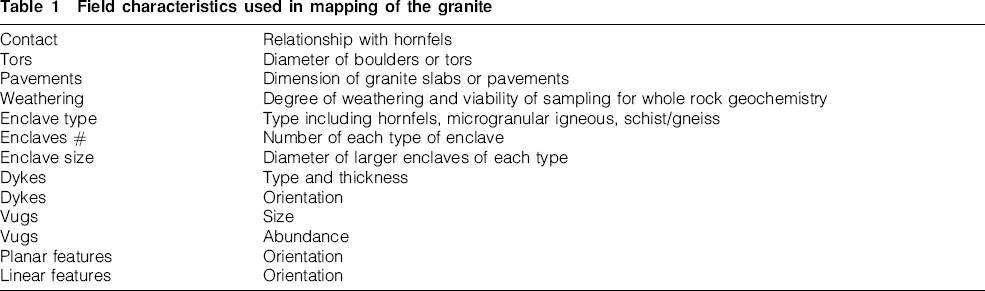
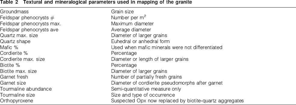
In this study, a starting assumption was made that many of the field-observed parameters could assist in facilitating a better understanding of a particular batholith. Structural analysis and geomorphology may delineate plutons, different parts of a given pluton, or subtly different granitic rock types. Radiometric data may identify subtle chemical differences and mineral textures may yield crystallisation histories. Based upon these considerations, the field program was designed to record a number of physical (Table 1) and textural (Table 2) rock characteristics at each locality.
Field characteristics used in mapping of the granite
Textural and mineralogical parameters used in mapping of the granite
Landforms, structures, geophysics and enclaves
Geomorphology
The Strathbogie batholith is divided into four plateaux by three topographic lows (Fig. 2A and B). From west to east these lows are the Goulburn River, Castle Creek and the Broken River, which divide the Strathbogie Ranges into the Tallarook, Highlands, Seven Creeks and Mt Samaria plateaux, respectively. The southern margin of the batholith is well defined and elevated due to the carapace of erosion-resistant hornfels. Thus most of the area of the batholith is drained northward through a limited number of waterways. Hughes Creek drains most of the Highlands plateau and Seven Creeks drains most of its eponymous plateau. The creek system of the plateaux is generally dendritic (mainly N–S and E–W, but locally NNE). There are many examples of stream capture involving small waterways, and a large-scale example is the capture of the ancestral north-flowing Goulburn River at Mansfield and its diversion westward past Yea. The modern Broken River now fills the previous northward course of the Goulburn River beyond Mansfield and on to Benalla (Phillips et al., 2002, p. 8).
The southern and western margins of the Tallarook plateau are defined by erosion-resistant hornfels that rises hundreds of metres above the metasedimentary sequences that lie outside the metamorphic aureole. The highest point of Mt Hickey is cordierite hornfels (805 m above mean sea level) and it has a 500 m steep (i.e. ∼20°) scarp on the southern side. On the SE flank of the Tallarook plateau, the Kerrisdale pluton crops out between 600 and 280 m. The Highlands plateau has an elevated hornfels terrain on its south and its numerous ranges of granitic hills are drained mostly by Hughes Creek, which exits the granite country near Avenel. The northern margin of this plateau is well defined by hills, 200 to 300 m high, that abruptly give way northward to the Cainozoic sediments of the Murray Basin. The Seven Creeks plateau has a number of prominent hills including the highest part of the batholith (Mt Strathbogie at 1031 m, Golden Mountain at 1028 m, Mt Barranhet at 820 m and Mt Wombat at 791 m). Its southern margin of elevated hornfels is remarkably linear for 30 km in an E–W direction. The northern margin mostly abuts the Violet Town Volcanics, where the granite intruded and contact metamorphosed the volcanic sequence (White, 1954; Clemens and Wall, 1984). The valley of the Broken River is 500 m below the eastern margin of this plateau, and the Mt Samaria plateau, which lacks exceptional hilltops, rises 700 m above the surrounding countryside. The highest ground here consists of numerous knolls and summits between 900 and the maximum of 968 m spread along the plateau rim for 10 km.
Lineament analysis
A lineament analysis of the Strathbogie Ranges, not including Mt Samaria, was prepared by Dr Kim Ely and published in Phillips et al. (2002). This highlights the quite different patterns in the three plateau areas. Field checking of lineaments indicates the presence of a shear zone parallel to the Goulburn River, marking the northern margin of the Tallarook plateau. However, most of the other lineaments do not reflect large faults or shear zones that are discernible on the ground.
A new lineament analysis was completed for the whole batholith using data on topography and stream-orientation (Fig. 3). The Tallarook plateau is dominated by N–S lineaments, with an E–W trend along the southern margin. The western part of the Highlands plateau, along strike from the Tallarook plateau, has a strong N–S pattern, but this plateau is dominated by NNE–SSW lineaments in the centre and NNW–SSE lineaments in the SE. In contrast with the plateaux on either side, Castle Creek is a 5-km-wide zone of strong N–S lineaments. The Seven Creeks plateau has a complex multiple lineament pattern involving intervals of strong E–W orientation and some with NNE–SSW, NNW–SSE and N–S directions. A few lineaments extend from the granite into the adjacent Violet Town Volcanics, but many terminate at this contact. On the Seven Creeks plateau, some approximately east-west lineaments parallel the hornfels contact on the southern margin. One lineament is 2 km north of the southern margin and one, a farther 6 km north, passes through the township of Strathbogie. Expressions of this latter E–W lineament are less well developed farther west on the Highlands plateau. The Mt Samaria plateau has minor NE–SW lineaments, including those that demarcate the batholith boundaries. In general, the lineaments are inferred to reflect either joints in the granitic mass or the boundaries of individual plutons within the batholith.
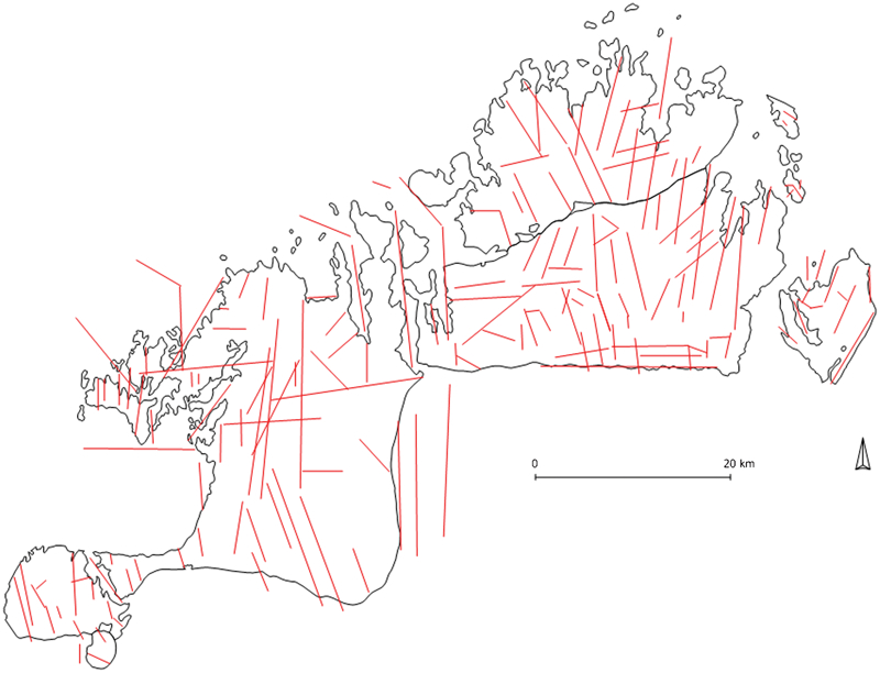
Lineament analysis of the Strathbogie batholith and Violet Town Volcanics based on elevation and stream data. The north-south and east-west trends of the batholith margin are replicated within the batholith, and there are also NE-SW and NW-SE directions. There is a contrast of lineament pattern between the east and west of the Seven Creeks plateau across a boundary transition that lies close to the Warrenbayne-Paps line, which has been identified in the geophysical data
Gravity and aeromagnetic images
Available datasets include Bouger gravity anomaly, total magnetic intensity and first vertical derivative of total magnetic intensity (Birch, 2003, chapter 1). The contrasts between granitic rocks, Cainozoic lavas and Palaeozoic metasedimentary rocks dominate the magnetic features. Consistent with the absence of strongly magnetic minerals in the granitic rocks, the first vertical derivative magnetic map clearly defines the batholith margins but reveals few internal features. The total magnetic intensity map is dominated by a 50 km diameter magnetic high that cuts across the northern margin of the batholith and is centred on Gooram (Fig. 2B; Meyers, 2002; McLean et al., 2010). The batholith is generally a gravity low relative to the surrounding Palaeozoic units, with some subtle gravity lows within the batholith, the latter being attributed to the granitic rocks extending to greater depths in those areas (e.g. the northern margin of the Tallarook plateau and the Gooram area). The gravity low also encompasses the Violet Town Volcanics, suggesting that these are relatively thin. Indeed, the volcanic succession here is now only 430 m thick (Clemens and Wall, 1984) and, based on the gravity map, cannot be underlain by any great thickness of granitic rock. There is a significant change across the NNW-trending Warrenbayne–Paps line (i.e. the line joining these two locations, Fig. 2A) with an area of lower-gravity response east of the line. This line is not reflected in aeromagnetic imagery nor in the first vertical derivative map, but is reflected in the radiometric data, specifically in the higher U and K responses to its east. Although the gravity low east of the Warrenbayne–Paps line has been attributed to the Carboniferous Mansfield Basin and Wabonga Cauldron (McLean et al., 2010), this explanation is unlikely to account for the gravity change across the Strathbogie batholith where neither of these rock units is present.
The gravity pattern is compatible with relative uplift of the Seven Creeks plateau between N–S faults along Castle Creek and through the Warrenbayne–Paps line. Thicker granite east of this line may account for the lower gravity response. The data are also compatible with the presence of a magma feeder zone lying beneath the Tallarook plateau, with the batholith extending to greater depth here, and with only a thin sliver of granitic rock to the NW around Avenel.
Radiometric ratios
Airborne radiometric data (K, Th and U) clearly delineate the outer margin of the batholith and also help distinguish some internal features (Table 3). Potassium is high across the batholith compared with the surrounding metasedimentary rocks, and there are three distinctly lower-K parts of the batholith. Two are small central sections of the Tallarook and Mt Samaria plateaux, and the other is much of the Seven Creeks plateau, excluding the area in the far east. Total thorium counts are high in Kerrisdale and the northern Tallarook plateau but lower in the centre of that plateau. Thorium is high throughout the southern Highlands plateau but low in the north, high in the west and centre of the Seven Creeks plateau, but low in the east including Mt Samaria. Uranium counts are high in Kerrisdale and the northern Tallarook plateau but lower in the centre of that plateau. U is high throughout the southern Highlands plateau but low in the northwest. U is also high east of Castle Creek toward Mt Samaria and particularly high in the far eastern part of the Seven Creeks plateau.
Gravity and radiometric characteristics of parts of the batholith
Distinctive sections of the batholith include the southern part of the Tallarook plateau (with K, Th and U all low), the northern part of Highlands plateau (with higher K, Th and U), the central Seven Creeks plateau (with low K), and the eastern part of the Seven Creeks and Mt Samaria plateaux (with low gravity and Th, but high U). We conclude that high K indicates the highly differentiated felsic roof zones of the batholith, and high Th reflects the deeper zones where biotite with numerous monazite inclusions is more abundant. The relationship between K, Th and U responses changes across the Warrenbayne–Paps line.
Tors and pavements
The outcrop expression of the granitic rocks varies. There are small and large boulders (0·5 m diameter for the finer-grained aplitic and microgranitic rocks, and tors of 10 to 15 m diameter for coarser-grained rocks), extensive pavements that are tens, and rarely hundreds of metres extent, and zones of weathered rock with little outcrop (Fig. 4). In grassy countryside, the boundaries of areas with boulders are commonly quite sharp and traceable over many kilometres. Boulders are well developed near the southern margin of the Seven Creeks plateau and east of the Warrenbayne–Paps line. They are also common in the southern part of the Highlands plateau, and locally on the Tallarook plateau. Pavements of 10 m or greater are common in the north of the Highlands plateau, the west of the Seven Creeks plateau and locally on the Tallarook plateau. They are uncommon on the Seven Creeks plateau east of the Warrenbayne–Paps line.
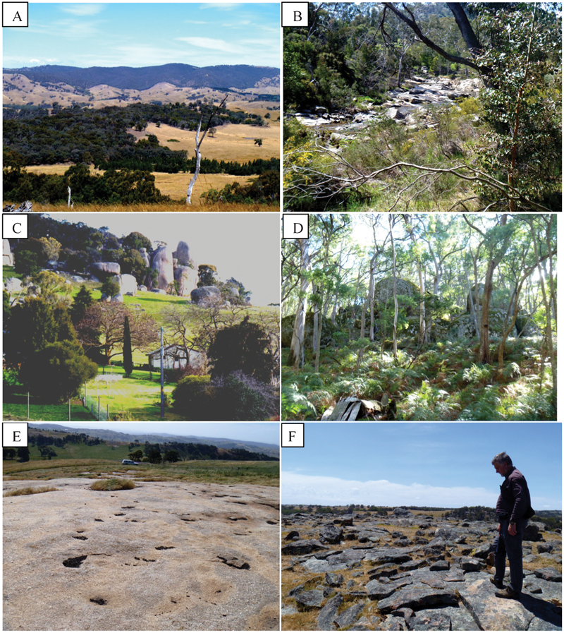
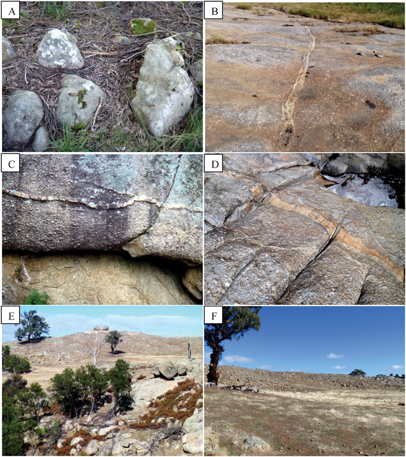
Photographs of the various landscape features that characterise the Strathbogie plateaux. (A) View southward to the Tallarook plateau from the Highlands plateau. The Goulburn River is masked by trees in the foreground, and is ∼400 m below the plateau top. B) Seven Creeks, SE of Gooram, which drains much of the Seven Creeks plateau. (C) Tors of 15–20 m height in the centre of the Highlands plateau. (D) Tors up to 5 m height in the Lightning Ridge pluton. This eastern part of the Seven Creeks plateau is thickly forested. (E) Pavements of up to 100 m size in the centre of the Highlands plateau. Most of this plateau is open farmland. (F) Aplitic layer, inferred to be very close to the roof of the batholith at Dolly Brae. The photograph was taken along the near-horizontal aplite surface but, in the midground and to the right, creeks have eroded over 100 m below this surface
Weathering
The degree of weathering of each outcrop was judged on the basis of samples being suitable for one or more of whole-rock geochemistry, petrography, field observations, or none of these. Fresh rock can be obtained from most districts, especially where there are newer blasted road cuttings, but we cannot determine whether this material is truly representative of its district. For example, on some poorly exposed plateau areas there is sparse outcrop of more biotite-rich granite and major intervals between outcrops. We recognise that different rock types and textural varieties within the batholith might have quite different outcrop characteristics. However, this limitation on physical examination is partially mitigated through the use of remotely-sensed geophysical data.
We suggest that there is a strong inter-relationship between the lineament pattern, outcrop forms, weathering and erosion. It is assumed that joint patterns within the granite are reflected in our mapping of boulders, pavements and lineaments. Pavements result from strong near-horizontal jointing whereas boulders, and their sizes, reflect the presence of intersecting near-vertical joint sets and the spacings between the individual joints. The lineament analysis primarily reflects watercourses and intervening hills, and its strong dendritic pattern is inferred to mirror joint patterns in the granite rather than any pattern inherited from the metasedimentary rocks that once formed the carapace of the batholith. In turn, we interpret these differences in response as being influenced by the grain sizes of the rocks and the occurrence of layering within the plutons, on a variety of scales. We suggest that these features reflect the construction of the batholith from numerous pulses of magma delivered from below but spreading laterally within the growing intrusion (see e.g. Price and Pitcher, 1999; Glazner et al., 2004; Clemens and Birch, 2012).
Enclaves
Enclaves (i.e. rock inclusions enclosed within granitic rocks) are generally uncommon in the Strathbogie batholith and comprise much less than 1% of its overall volume. Some large areas are virtually devoid of enclaves (e.g. the batholith east of the Warrenbayne–Paps line). The main enclave types are, in decreasing order of abundance, angular country-rock hornfels xenoliths, ovoid to discoid microgranular igneous enclaves, rarer tabular to jagged-edged high-grade metapelitic schist and gneiss xenoliths, and scarce angular to tabular white vein quartz xenoliths (Fig. 5). The majority of enclaves are 1 to 3 cm in diameter, those up to 15 cm are widespread, and a very few metre-scale enclaves have been recorded.
Photographs of some representative enclaves. (A) Thin slab of pelitic hornfels viewed almost perpendicular to bedding. (B) Cordierite hornfels in which pock marks of weathered-out cordierite are quite visible. (C) Quartz-rich xenolith in a granitic host rock that also contains several fresh garnet crystals, as indicated. (D) Psammopelitic hornfels containing less cordierite than A or B. (E) Mafic microgranular igneous enclave. (F) High-grade metapelitic gneiss xenolith
The hornfels xenolith suite is dominated by pelitic to psammopelitic cordierite and biotite hornfels, with some siliceous psammitic hornfels, and scarce calc-silicate hornfels. These xenoliths are mostly 1 to 10 cm and rarely up to 50 cm across. They are more abundant and of larger size along the batholith margins, especially on the southern edge of the Seven Creeks plateau (i.e. Golden Mountain) and on the northwestern edge of the Highlands plateau (Mittagong). The rounded, igneous-textured, microgranular enclaves are more abundant in the west of the batholith and are up to 30 cm in diameter, although most are in the range 5–15 cm. The gneissic and schistose xenoliths occur only in the northern part of the batholith, and appear to be absent in the far western and far eastern sectors. Although these amphibolite-facies metamorphic xenoliths were found at less than 1% of outcrops, they occur in clusters of 2–10 similar enclaves and appear to be individually smaller in size near the batholith margins. There are rare xenoliths of vein quartz that are up to a few cm across.
Aplites, pegmatites, veins and vugs
Aplitic dykes of a few centimetres thickness are widespread throughout the batholith. They can be traced for 100 s of metres where some crop out as boulders ∼0·5 m in diameter (Fig. 6). Pegmatites appear to be absent from much of the batholith. However, pegmatite dykes and vugs (i.e. miarolitic cavities generally of a few cm diameter) are known from the SE part of the Seven Creeks plateau (Tallangallook), and especially in the NW sector of the Highlands plateau, i.e. Lorenz and Callen Range (Fig. 7). Quartz veins of a few cm width are more common in the NW near Avenel where one quartz vein set, several metres wide, is traceable for 500 m in the granitic rocks.
Photographs of aplite dykes and larger masses of aplitic leucogranite. (A) Characteristic 0·5 m tors developed on aplitic leucogranite and larger aplite dykes. (B–D) Aplite dykes (a few cm wide) that are widespread across the batholith. (E–F) Horizontally stratified aplitic unit forming a low ridge east of Mittagong, overlain in (E) by two remaining tors on a hilltop, and underlain by the flat area of no outcrop in (F)
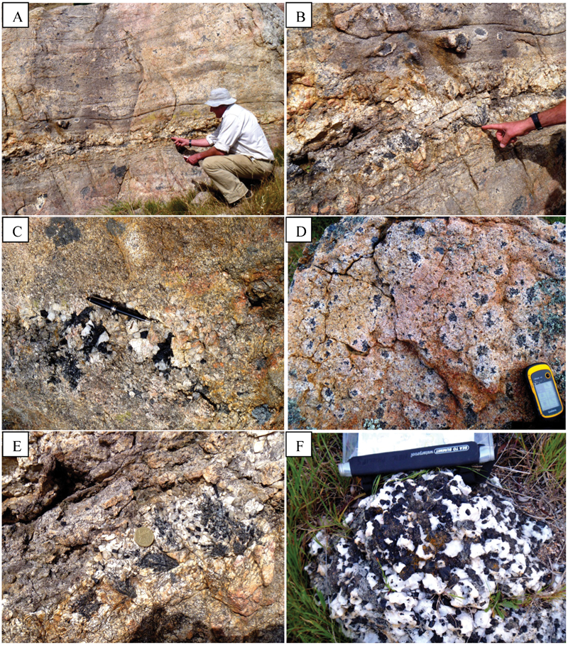
Photographs of pegmatite dykes and related tourmaline-quartz intergrowths from the NW Highlands plateau near Avenel. (A) Pegmatite dyke up to 20 cm wide within a very felsic unit; the rock itself is not in its original orientation. (B) Same pegmatite with clusters rich in tourmaline above the dyke. (C) Radiating tourmaline crystals with pegmatite. (D) Aggregates of tourmaline in an aplitic layer close to the top of the batholith; similar setting to 7C. (E) Aggregate of tourmaline and quartz. (F) An atypical rock comprised of just quartz and tourmaline in approximately equal proportions
The Tallangallook pegmatite, north of Bonnie Doon, is a ten-metre-wide, complex pegmatite that contains graphic granite, aplite, tourmaline- and muscovite-rich pegmatite and vein quartz (Phillips et al., 2002; Fig. 7). The nearby Crystal King mine consisted of a number of vertical, 1- to 3-metre-wide, aplite pipes in which the feldspar was weathered to clay. The quartz occurred in large vugs and as single crystals weighing over 100 kg. This mine was a significant source of high-quality, natural, piezo-electric quartz crystal used in electronic devices in the previous century, prior to the introduction of synthetically grown crystals (Owen, 1945).
Faults and shear zones
Faulting is uncommon both within the granite and against country rocks on the margins of the batholith. Most shear zones are only 1–2 cm wide and a few metres long. An exception is the shear zone recorded in the SW, parallel to and near the Goulburn River where it divides the Tallarook and Highlands plateaux. This shear zone is orientated at 145–167°, with a 76–90° W dip, nearly parallel to jointing in this area (Phillips et al., 2002, p. 59).
Mineralogical and textural characteristics
Considering the rocks that lack large alkali feldspar phenocrysts and the textures of the coarse-grained matrices of the porphyritic rocks, much of the Strathbogie batholith is comprised of rocks with seriate textures (i.e. with crystals varying more-or-less continuously in size; Figs. 8 and 9). Thus, the grain size of some of the largest crystals has been recorded, with fewer average grain size values given.
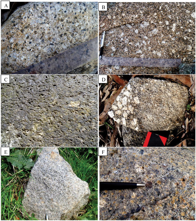
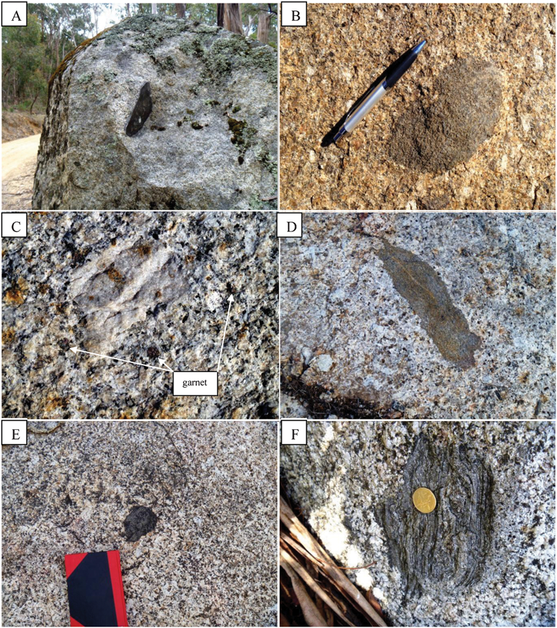
Photographs of some representative rocks. (A) Equigranular granitic rock, from the western margin of the Mt Samaria plateau, showing tabular cordierite crystals 6–8 mm long. (B) Feldspar phenocryst-rich granitic rock with tabular cordierite, near Gooram in the Mt Wombat pluton. (C) Pock-marked surfaces that result from preferential erosion of altered cordierite crystals. (D) Sharp boundaries, such as this example from the Highlands plateau, between phenocryst-rich and phenocryst-poor granitic rocks, are rare. (E) Representative finer-grained granitic rock from the Kerrisdale pluton. (F) Fresh garnet crystal 1 cm across in a rock near Mittagong
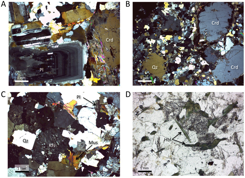
Photomicrographs of some textural features in the rocks of the Strathbogie batholith. Note that all are at the same scale. (A) Texture of a typical monzogranitic rock, from the Mount Wombat pluton, showing subhedral, oscillatory-zoned plagioclase with narrow, near-solidus overgrowths and a subhedral magmatic cordierite crystal with a few small biotite inclusions in its core and partially altered to muscovitic white mica along its margin and internally along fractures (sample S1, crossed polarisers). Note that the mineral abbreviations used here are taken from Whitney and Evans (2010). (B) Typical texture of a relatively fine-grained porphyritic microgranite from the roof zone of the Mount Wombat pluton. The figure shows a small subhedral quartz phenocryst and a glomeroporphyritic group of somewhat corroded but subhedral cordierite crystals set in a microcrystalline groundmass of polygonal quartz and feldspar (sample S0, crossed polarisers). (C) Texture of a leuco-microgranite from the Lightning Ridge pluton. Note the presence of an early-formed euhedral quartz crystal, plagioclase, microperthitic K-feldspar and what appears to be magmatic muscovite. Most of the quartz in this pluton is actually anhedral and polygonal to cuspate in shape, like the rest of the quartz grains in this micrograph (sample S17, crossed polarisers). (D) Euhedral green hornblende crystals intergrown with polygonal quartz, K-feldspar and subordinate sodic plagioclase in the I-type Tallangallook hornblende microgranite (sample S16, plane light).
Feldspar phenocrysts
Potassic alkali feldspar (Kfs) phenocrysts are prominent over much of the Strathbogie batholith and range from 1 cm to rarely 5–8 cm in length. Plagioclase is an important component of the groundmass and, in some rocks, also forms phenocrysts that are smaller than the Kfs phenocrysts. The distinction of feldspar type is difficult in the field in both fresh and weathered rock surfaces. This may be a general problem in reduced granites in which, due to the low abundance of Fe3+, the alkali feldspars do not alter or weather to pinkish colours. During mapping, the abundance of feldspar phenocrysts was recorded as the number of phenocrysts per unit surface area, i.e. crystals m−2.
Despite there being considerable variation in phenocryst abundance within single outcrops, there are regular patterns in districts and across large parts of the batholith. For example, in the south of the Highlands plateau there is a road section of 100 m with a variation of phenocryst abundance from 30 to 200 crystals m−2. Such an outcrop area would be mapped as phenocryst-rich despite there being several subordinate parts that might appear phenocryst-poor if mapped at a much larger scale. The largest feldspar phenocrysts occur in the south of the Highlands plateau and the southern edge of Seven Creeks plateau. However, the average size of phenocrysts varies only slightly.
Feldspar phenocrysts are less common in rocks of the main Tallarook plateau, the NW part of Highlands plateau, in the Lightning Ridge area and in the rocks of the Mt Samaria plateau (Fig. 10). These Kfs phenocrysts are well developed in the topographically lower part of the Kerrisdale pluton, and in the southern part of the Highlands plateau. An unusual rock type occurs 3 km west of Lorenz. This has a bimodal distribution of feldspar phenocrysts sizes (3–4 cm and around 1 cm) tentatively interpreted as quenching of a magma that contained some pre-existing, large Kfs phenocrysts and which then developed some smaller Kfs phenocrysts during more rapid solidification.
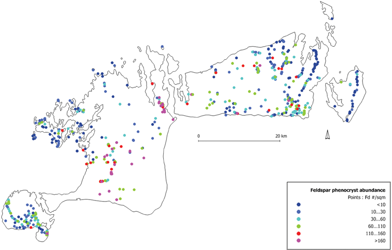
Map showing the abundance of feldspar phenocrysts in the Strathbogie batholith. The rocks in the southern part of the Highlands plateau have higher phenocryst contents, and phenocryst abundance is lower along the northern margin of the batholith. However, there is considerable variation in abundance in some outcrops, even on the scale of tens of metres, probably due to local flow-segregation effects
Quartz
Quartz is a distinctive small phenocryst phase over much of the batholith, with euhedral (β-quartz form) to rounded subhedral crystals commonly 4–8 mm across and rarely more than 12 mm. Quartz typically comprises 20–30 vol.-% of the rocks and, when abundant, the large crystals dominate the texture. The largest quartz grains are concentrated in the Highlands and western Seven Creeks plateaux (Fig. 11). Much smaller quartz crystals characterise the SE Tallarook plateau (Kerrisdale) and the east of the Seven Creeks plateau. In the latter area (Lightning Ridge) much of the quartz has a radically different shape and size, with 3 mm anhedral quartz crystals dominating. In the Kerrisdale area, the subhedral to euhedral quartz averages ∼3 mm in diameter.
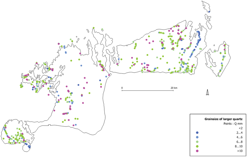
Map of the maximum grain sizes of quartz crystals, showing clearly two areas in which the quartz is finer-grained – the Kerrisdale pluton in the SW and the Lightning Ridge pluton in the eastern part of the Seven Creeks plateau. These differences probably relate to differences in magma composition, bringing about differences in the position of quartz relative to other minerals in the crystallisation sequences of the magmas
Cordierite
Cordierite usually makes up 3–10 vol.-% of the granitic rocks (Fig. 8A). However, in patches of a few square metres, it may comprise up to 30 vol.-%. When abundant, cordierite weathers out preferentially to produce a distinctive pock-marked appearance on rock surfaces (Fig. 8C). It forms euhedral, tabular crystals of 5–10 mm, and rarely to 15 mm length, and is distinguished by its rectangular cross-sections and very common partial to complete alteration to chlorite or clay minerals. Rare unaltered cordierite is translucent grey with a resinous to waxy lustre. Polycrystalline aggregates up to 20 mm across of cordierite, biotite and secondary chlorite commonly show polygonal outlines and occasionally have cores of corroded garnet, indicating they are pseudomorphs after garnet crystals. Cordierite is more abundant and larger in the Highlands and Seven Creeks plateaux, and less abundant in the far west and far east of the batholith.
Biotite
Biotite is generally subordinate to cordierite (i.e. 3–8 vol.-%) and, in some more felsic variants and part of the far eastern Seven Creeks plateau, biotite is virtually absent. It is the dominant mafic mineral in the southern part of the Tallarook plateau and the SE part of the Seven Creeks plateau. Biotite forms euhedral booklets that are typically 3–5 mm in across, with larger grain size and greater abundance in the southern portions of both these plateaux. In some locations, where the degree of weathering does not allow accurate estimation of cordierite and biotite abundances, a single total mafic mineral abundance was recorded.
Garnet
Garnet is a widespread minor mineral throughout the Highlands plateau and the western part of the Seven Creeks plateau but is relatively rare in the Tallarook and Mt Samaria plateaux. It occurs in several forms, most commonly as ∼10 mm euhedral crystals that are partially replaced by cordierite and biotite (Fig. 8F), but also as minor, late, anhedral grains that show no signs of reaction with the magma (see Phillips et al., 1981, Fig. 3 and Table 3). This type of anhedral garnet is also rarely present in the igneous-textured microgranular enclaves. As with the other phenocryst minerals, the euhedral garnets in the Kerrisdale pluton are generally smaller than those in the rest of the batholith.
Tourmaline
Tourmaline is sporadically distributed as a minor, late-crystallising mineral, with higher abundance in the NE near the Violet Town Volcanics, in the NW of the Highlands plateau near Lorenz and Mittagong, and in the southern part of the Mt Samaria plateau (Fig. 12). It occurs as veinlets 1–2 mm wide, as part of the groundmass in some very leucocratic variants of the granite, and in pegmatite and aplite dykes (see Figs. 6 and 7). More rarely, layered pegmatitic rocks contain intergrowths of tourmaline and quartz up to 1 m across, with tourmaline crystals up to 2·5 cm in diameter and 10 cm long.
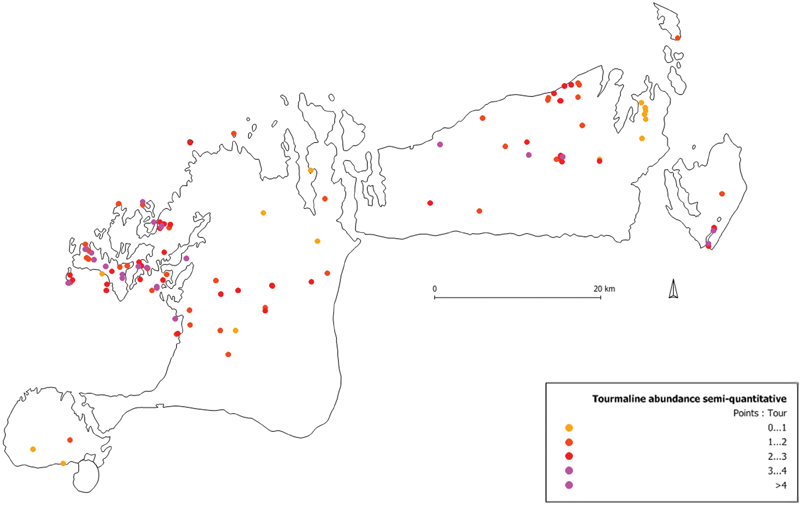
Map of the distribution of tourmaline showing that it is far more common in the northern sector of the batholith where the highly fractionated rocks of the roof zone are concentrated. Sites where tourmaline is absent or was not confirmed (due to fine grain size or dirt- and dust-covered outcrops) are omitted from the figure
Orthopyroxene
No orthopyroxene has been found in any of the granitic rocks but pseudomorphs of biotite plus quartz after orthopyroxene are relatively common in thin sections, and can also be identified on some fresh rock surfaces in the field. These pseudomorphs also contain concentrations of accessory apatite, pyrrhotite and ilmenite, which are inferred to have been included in the original orthopyroxene crystals. This interpretation is based on experimental evidence that the Strathbogie magmas would have contained orthopyroxene as an early-crystallised phase (Clemens and Wall, 1981), and textural evidence for the formation of such pseudomorphs, in various stages of arrested development, in S-type volcanic and hypabyssal rocks (e.g. Clemens, 1981; Clemens and Wall, 1988). The orthopyroxene pseudomorphs are recorded from only a few locations and, when present, are always in low abundance, with just one or two identifiable examples per location. However, thin-section evidence suggests that their abundance is likely to be considerably higher than recorded here because of the difficulty in identifying these pseudomorphs in outcrop or hand specimen.
Hornblende
The I-type Tallangallook hornblende microgranite in the NE part of the batholith, west of Lightning Ridge (Phillips et al., 1981) contains ∼1 mm, green, needle-like hornblende crystals, as well as magnetite and titanite. These minerals occur in none of the other rocks in the batholith (Fig. 9D).
Interpretations
Subdivision of the Strathbogie batholith has proven difficult in the past, and we acknowledge the shortcomings in our own original attempt (Phillips et al., 1981). Part of the difficulty has been the mostly uniform character of these cordierite-rich rocks over much of the batholith, but also the lack of internal metasedimentary screens and the scarcity of mappable field contacts.
The aim here is to use field and remotely-sensed data to subdivide the batholith into a number of plutons, which we define as mappable units with spatial coherence that are inferred to reflect distinct intrusive units. At this stage we make no assumptions about whole-rock compositions, relative ages or the number of magma pulses within the plutons or the batholith as a whole. Geochemical data have not been used in the present definitions of the plutons. A subsequent paper will deal with the petrogenesis and explore the geochemical distinctions, if any, between the plutons that we define here. The present subdivision into plutons is open to improvement as more field data are collected and integrated with petrological and geochemical data. As a rough guide, there are now data-recording stations on average every 2 km2, several traverses of 5–10 km length, and an extant whole-rock analysis for every 30 km2. The following sections describe the characteristics of each identified pluton (Fig. 13).
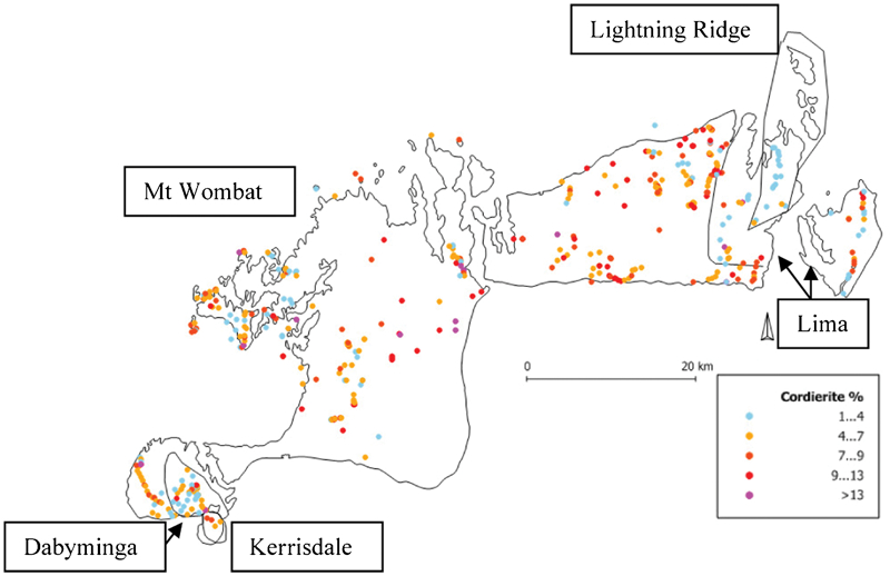
Map showing the distribution of the five plutons, with the Mt Wombat pluton making up the bulk of the batholith, and the abundance of cordierite
Kerrisdale pluton
The Kerrisdale pluton lies on the SE of the Tallarook plateau abutting the Dabyminga pluton and is about 3 km in its longest dimension. There may be a partial metasedimentary screen separating these two, and the radiometric map suggests that the mapped shape of the Kerrisdale pluton reflects topography rather than its true, subsurface shape, which is more equant and roughly circular. The main rock type is a porphyritic micro-monzogranite that crops out as relatively unweathered 0·5–2 m tors. Pavements are rare, and enclaves are restricted to a few small hornfelsic xenoliths and microgranular igneous types.
Compared with the rest of the batholith, all the minerals in the Kerrisdale pluton have significantly smaller grain sizes. Feldspar phenocrysts are mostly around 5 mm (but up to 10 mm) and become smaller and less abundant with greater topographic elevation, consistent with a closer approach to the roof of the pluton. Crystals of quartz (1–5 mm but mostly 2–3 mm), cordierite and biotite (2–4 mm) are all smaller than their counterparts in the rest of the batholith. The proportion of feldspar phenocrysts is high at lower elevations (200 phenocrysts m−2) but much lower at higher elevations (0–20 phenocrysts m−2), again consistent with the occurrence of quenching toward the roof of the pluton. Significantly, the rare garnet phenocrysts here are generally smaller (4–8 mm) than in the coarser-grained rocks in rest of the batholith. This evidence was used by Phillips et al. (1981) to indicate that the garnet, at least in part, grew from the magma at emplacement depth, rather than having been carried up from the magma source as restitic crystals. There are local areas where biotite is more abundant than cordierite, but usually cordierite dominates. Tourmaline and vugs appear to be absent. Marginal parts of the pluton appear finer-grained, possibly representing either thermal chilling or pressure quenching. Relative to the bulk of the batholith, the radiometric data indicate high K, Th and U contents. The Kerrisdale pluton is best distinguished on the basis of its relatively fine-grained rocks. This characteristic and the plan shape inferred from the radiometric map suggest that the Kerrisdale pluton may take the form of a relatively thin disc or laccolith. Such a thin body would also be consistent with relatively rapid cooling and a consequent small grain size.
Dabyminga pluton
The Dabyminga pluton (∼5 km in diameter) occurs across the top of the Tallarook plateau in forested country, where it crops out poorly and is generally weathered. Apart from being adjacent to the Kerrisdale pluton, it has the Mt Wombat pluton to its north and hornfels around the rest of its periphery. On average, the Dabyminga pluton is somewhat more felsic than the Kerrisdale pluton, the dominant rock type being a biotite-phyric monzogranite to syenogranite that forms sparse tors up to 3 m in diameter and rare pavements. Feldspar phenocrysts are up to 2 cm long and only moderately abundant (20 to 40 crystals m−2, and rarely up to 100 crystals m−2).
Quartz is less abundant than in much of the batholith and its crystals are normally only 5 mm across (cf. 8–10 mm elsewhere). Cordierite and biotite have similar sizes and abundances (4–5 mm and 3–5 vol.-% each), locally with fresh cordierite near the centre of the pluton. Minor tourmaline is confined to a single location, where it occurs as veins, but garnet has not been recorded. Enclaves are generally rare and hornfelsic, but very abundant at Warragul Rocks. This pluton has a weaker radiometric signature than much of the batholith, due to the low-intensity signals from K, U and especially Th. Mineralogically, its distinctive features are relatively abundant biotite, poor outcrop, small tors, negligible tourmaline, vugs and garnet, modest modal quartz content, and intermediate grain size.
Mt Wombat pluton
This large and highly variable pluton makes up the largest part of the batholith and contains many different rock types; it has potentially mappable components of many tens of km2. At least five separate sections of the Mt Wombat pluton are recognised, based on textural and geophysical differences. However, the pluton, as a whole, also has elements of commonality. The rock types range from relatively mafic porphyritic micro-monzogranite to aplitic-textured alkali feldspar microgranite; garnet is widespread. Pavements, tens of metres in extent, are more common in this pluton than elsewhere in the batholith and tors of 5 to 10 m diameter are also widespread. This is the part of the batholith with the most pronounced layering. The degree of weathering and exposure are quite variable. Mt Wombat is the only pluton that contains rather common and large enclaves of all types, and its northern half is the only area in which gneissic and schistose enclaves are widespread (though still uncommon overall). With the exception of layers of aplitic-textured rocks at higher elevations (the inferred roof of the batholith), the rocks of this pluton contain abundant, large, euhedral to subhedral quartz, mafic minerals dominated by cordierite, and the largest and most abundant feldspar phenocrysts in the batholith. The northern part of the Mt Wombat pluton contains the highest concentration of vugs, pegmatite patches and dykes, and extensive aplitic layers. Tourmaline is abundant and widespread here, and topaz is also present, in lesser abundance.
Lightning Ridge pluton
This pluton is elongate in a N–S direction, ∼20 km by 5 km, and includes some outlying hills near Swanpool. It coincides with a gravity low that extends eastward under the Mt Samaria plateau but ends near the Warrenbayne–Paps line immediately west of the pluton. The radiometric signature is one of high K and U with low Th. The Lightning Ridge pluton is co-linear with the elongate, Cambrian Glen Creek ‘greenstone’ sliver that occurs SE of Mt Strathbogie in the contact aureole.
This pluton crops out as 1–5 m boulders, but there are no pavements, and it appears to entirely lack enclaves. As mentioned above, the quartz in the rocks of this pluton is anhedral, rather than subhedral to euhedral as in the other plutons. This anhedral quartz is also finer-grained (1–5 mm, but mostly around 3 mm). The modal abundances of biotite and cordierite are both low (with total mafic mineral contents <5 vol.-%), and these minerals are also rather fine-grained (2–4 mm). These leucocratic rocks also lack significant feldspar phenocrysts, vugs, tourmaline and garnet. The most distinctive features of the rocks in this pluton are the small anhedral quartz crystals, the low contents of mafic minerals and lack of feldspar phenocrysts.
Lima pluton
The Lima pluton occurs in the eastern sector of the Strathbogie batholith and includes the Mt Samaria plateau and the eastern part of the Seven Creeks plateau, surrounding the Lightning Ridge pluton. The main rock type is porphyritic microgranite, which forms tors of 2–5 m diameter and minor pavements. It contains negligible enclaves. The pluton is distinguished by its radiometric character in having relatively elevated K and U with low Th compared to the batholith overall. In this pluton the quartz is up to 8 mm, and cordierite less than 10 mm. Cordierite is more abundant than biotite. The Lima pluton contains only minor occurrences of tourmaline, vugs and garnet.
Tallangallook hornblende microgranite
This small body of I-type, hornblende-bearing microgranite was recorded in the NE part of the batholith, west of Lightning Ridge. It is exposed over <200 m and is geochemically characterised by being less mafic and lower in P2O5 but with much higher Sr, Ce, Th, Nb and Zr than the S-type rocks with similar SiO2 contents (Phillips et al., 1981). It also has a significantly higher Na2O content than the S-type rocks and it is metaluminous rather than peraluminous. It contains K-feldspar, quartz, plagioclase and minor hornblende, with accessory ilmenite, magnetite, titanite, apatite and zircon. The rock is sparsely porphyritic with quartz (6 mm) and plagioclase (4 mm) phenocrysts.
Distinguishing features of individual plutons
The various plutons are best distinguished on the basis of texture, including grain size, of the dominant minerals, but there are also several subtle differences that support the subdivisions. The latter include the nature and distribution of garnet, vugs, tourmaline, enclaves and dykes. The Kerrisdale and Lightning Ridge plutons have distinctly finer grain sizes, and there is anhedral quartz in the latter. Both lack the mineralogical indications of being near the fractionated top of a batholith (i.e. vugs, tourmaline and pegmatitic to aplitic dykes). The Dabyminga and Lima plutons have only minor garnet and enclaves and, although they too lack the indicators of being near a batholith top, they have grain sizes and textural characteristics more akin to the major Mt Wombat pluton. Radiometric imagery indicates differences in element abundances that coincide with the mineralogical and textural contrasts (Table 4). The Mt Wombat pluton is quite variable but, compared to the rest of the batholith, it has more tors, pavements, enclaves of all types, aplite, pegmatite, vugs, feldspar phenocrysts, cordierite and garnet. The Warrenbayne–Paps line is identified as an important break that probably reflects different magma pulses and greater batholith depth east of the line. This line is demarcated by gravity and radiometrics (K, U and, less so, by Th).
Field, geophysical and mineralogical characteristics of each pluton
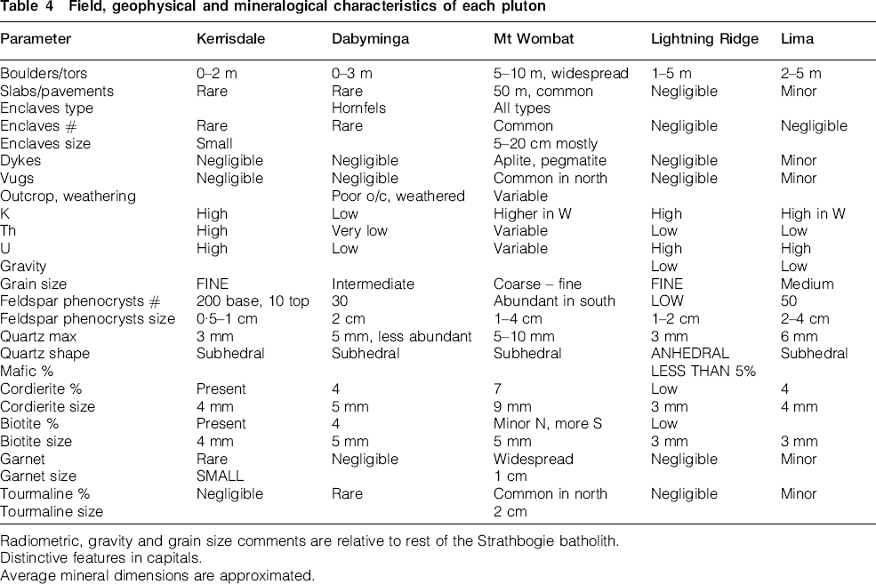
Radiometric, gravity and grain size comments are relative to rest of the Strathbogie batholith.
Distinctive features in capitals.
Average mineral dimensions are approximated.
This field-based sub-division of the batholith has provided the basis for more detailed field, petrographic, geochemical, geophysical, and possibly geochronological, work to determine the relative timing of the formation of the component plutons. Current indications are that the small plutons in the west and east may be younger than the Mt Wombat pluton which itself may eventually prove to have several recognisable component parts.
Discussion and conclusions
An understanding of the different components of a major batholith assists in the interpretation of physicochemical processes that occurred at the magma source and during transport and emplacement (Clemens, 2012). This preliminary study has identified a probable roof zone, potential separate plutons (two of which are probably thin laccoliths), dykes and some important variations in rock (and by implication magma) composition. It has established that magmatic garnet and especially cordierite are widespread, whereas metaluminous hornblende-bearing rocks are both very rare and extremely limited in extent.
Two batholiths that are rather similar in composition to the Strathbogie are the South Mountain batholith of Nova Scotia in Canada, and the Peninsula pluton (batholith) of the Cape Granite Suite, east and south of Cape Town in South Africa. Both these have common cordierite and some garnet, and both were emplaced at shallow levels in the crust. The Peninsula pluton (batholith) has not been subdivided or mapped internally whereas the South Mountain Batholith is known to contain 13 different plutons that were mapped on the basis of well-exposed intrusive contacts and obvious textural and internal structural dissimilarities (MacDonald, 2001).
The upper part of the Strathbogie batholith is well exposed in the NW near Avenel, Dolly Brae and Lorenz. Here there are pegmatite dykes, aplites, cordierite granite with garnet but negligible biotite and fewer phenocrysts in a finer-grained (aplitic) groundmass than elsewhere. These rocks appear to be nearly horizontally layered and most likely represent the roof zone of the batholith where highly differentiated, volatile- and light-element-enriched magmas locally congregated. The same near-roof rock package can be recognised 5 km to the SE in the Callen Range, where creeks cut down through hornfels to expose the contact. This NW Highlands plateau has widespread occurrence of tourmaline, vugs and aplitic dykes, all compatible with this part of the batholith being very close to the roof.
An important outcome of the present work is the recognition of the spatial relationship between the Lima and Lightning Ridge plutons, and the northward projection of the sliver of Cambrian Glen Creek rocks. The Glen Creek exposures of the Cambrian sequence were first recognised during mapping by Sandl (written comm., 1989) and comprise mostly sedimentary and felsic volcanic rocks. The possibility of the Cambrian rocks having influenced the emplacement style and/or magma chemistry of the subjacent Strathbogie granitic rocks will be examined in a subsequent petrogenetic study.
Among the hundreds of granitic intrusions in the LFB, the Strathbogie batholith is unusual in its quite reduced nature, widespread occurrence of magmatic cordierite and garnet, its high (subvolcanic) level of emplacement and strongly discordant orientation with respect to regional structures, though other large intrusive bodies in this part of Victoria share this last attribute (e.g. the Tynong, Harcourt and Cobaw batholiths). This study has demonstrated that these unusual characteristics are a widespread feature of the batholith rather than being local anomalies.
In the absence of mappable rock contacts and country rock screens or exposed internal contacts, this field approach, supplemented by an airborne radiometric survey, is especially useful for understanding internal variations in the batholith. The datasets are providing additional information on the occurrence of various minerals, and the mineral modes reflect bulk-rock composition, and source and emplacement crystallisation conditions. When not obscured by vegetation effects, the radiometric pattern (U, Th and K) reflects magma source variations, and the pavement and tor patterns reflect emplacement style, likely depth of emplacement and the development of joint patterns during cooling of the batholith.
Footnotes
Acknowledgements
This study builds on a number of projects throughout Central Victoria with Martin Hughes, and earlier studies within the Strathbogie batholith in partnership with Janet Hergt. Kim Ely, Katy Evans and Bence Paul have contributed to the fieldwork, and we acknowledge the BSc Honours theses and the field work carried out by Peter Nisbet, Ian Sandl, Deb Cownley, Cathy Dickins and Jamin Howman. We also acknowledge the input by Vic Wall in the original Strathbogie studies of the 1970s.
We thank Martin Hughes for his substantial assistance with the assembly and manipulation of the various geophysical datasets across central Victoria. These were collected by the Victorian Government as part of the Victorian Initiative for Minerals and Petroleum and provide a very valuable basis for any regional geological study such as this. Fieldwork has been greatly assisted by Nat Phillips, Gowanvale, Warrambie, and the many land owners around Avenel 37VRC, who have given permission to access their properties.
Several members of the granite discussion network shared their ideas on approaches to mapping plutons within batholiths and the definition of a pluton including John Bartley, Anne Nédélec, Sergio Rocchi, Jean-François Moyen, Allen Glazner, Ned Chown, Bernard Bonin and Scott Bryan.
Constructive comments from three referees are greatly appreciated.