
Abstract
Myanmar contains important deposits of tin, tungsten, copper, gold, gemstones, zinc, lead, nickel and silver. It has one of the most diverse and richly endowed collections of natural resources in Southeast Asia, largely reflecting a geological history stretching from the Late Triassic to the Miocene. At least three world class deposits include Bawdwin (lead–zinc–silver), Monywa (copper) and Mawchi (tin–tungsten). Myanmar can be divided into three principal metallotects: the Wuntho-Popa Arc, comprising subduction-related granites with associated porphyry-type copper-gold and epithermal gold mineralisation; the Mogok-Mandalay-Mergui Belt hosting both significant tin–tungsten mineralisation associated with crustal melt granites, and key orogenic gold resources; and the Shan Plateau with massive sulphide-type lead–zinc deposits. Myanmar as a jurisdiction remains poorly understood and underdeveloped with regards its natural resources. We have built a Geographic Information System database of known Myanmar deposits, outcrops and mineral occurrences as a tool for exploration targeting.
Introduction
Myanmar (Burma) is one of the largest countries within Southeast Asia, and as a jurisdiction has long been known to be richly endowed in deposits of tin, tungsten, copper, gold, silver, zinc, lead, gemstones, jade and hydrocarbons (Chhibber, 1934; Brown, 1936; Griffith, 1956; Soe Win and Marlar Myo Myint, 1998). Until the late 1930s it was a major producer of lead, silver, tin and tungsten; however, much of this industry was destroyed during, and in the two decades after, World War II. While there is some recent history of exploration and exploitation of mineral deposits within Myanmar (largely in the shape of UN-sponsored programmes in the 1970s and 1980s, and, with one or two exceptions, subsequent work by smaller Western juniors), as a jurisdiction it remains poorly understood, unexplored and hugely underdeveloped with regards its natural resources (e.g. Cox et al., 1981; Moores and Fairbridge, 1997). This lack of development is fundamentally due to the political, economic and geographical remoteness of the country. However, there remains considerable potential for future exploration to identify a diverse range of commodities, and in the light of recent domestic political progress, and the positive international response to this, the mineral investment community is revisiting Myanmar as a potentially new and emerging jurisdiction.
As part of the ongoing research at Oxford into the metallogenic and tectonic evolution of Myanmar, we have built a Geographic Information System (GIS)-based metallogenic database of Myanmar as a tool to aid exploration targeting. A relational database of known outcrops, mineral occurrences, alluvial deposits and historical workings has been geo-referenced alongside with tonnages and grades, and overlain onto the geological map of Myanmar.
Geological overview
The recent geological history of Myanmar is dominated by the Mesozoic–Cenozoic subduction and accretion of a series of plates and island-arc terranes that rifted from Gondwana in the south, and sutured onto the South China terrane during the staged closing of the Tethys Ocean. The history is similar to other terranes along the Tethyan margin (e.g. Tibet), with progressively younger continental collisions and associated suture zones from east to west. While the tectonic history is reasonably well constrained both further north in Karakoram-Himalaya-Tibet (Searle et al., 2011), and south in peninsula Malaysia (Searle et al., 2012), it is poorly understood within Myanmar.
Two principal collisional events dominate the Mesozoic-Recent geological history of Myanmar. The earlier Indosinian Orogeny, the Late Triassic closure of Palaeo-Tethys (Mitchell, 1977; Metcalfe, 2000, 2002; Wakita and Metcalfe, 2005; Sone and Metcalfe, 2008) describes the collision of the Sibumasu terrane with the Indochina terrane. The resulting suture, referred to as the Chiang-Rai or Bentong-Raub Suture, is thought to run through western Thailand and central Malaysia (Hutchison, 1973; Sone and Metcalfe, 2008). Sibumasu (Siam-Burma-Malaysia-Sumatra; Metcalfe, 1984) is defined as comprising the area west of this suture in northern and southwest Thailand, eastern Myanmar and western Malaysia, and represents a contiguous terrane that rifted from Gondwana in the Early Permian (Metcalfe, 2006).
The later closure of Neo-Tethys, and the initiation of the Himalayan Orogeny, has been dated along the Indus-Yarlung Tsangpo suture at ca 50 Ma (Garzanti et al., 1987; Searle et al., 1988, 2011; Green et al., 2008). The Neo-Tethys suture extends from the Himalayas south through Myanmar to link up with the Andaman Islands and the Wolya suture zone in Sumatra (Barber, 2000; Barber et al., 2005). The Himalayan suture is thought to outcrop in western Myanmar in the Mount Victoria Belt (Mitchell, 1989). This suture has, however, been cut by recent Neogene strike slip faults, most notably the 1200 km long dextral Sagaing Fault (Win Swe, 1972). This active north-south fault divides eastern and western Myanmar, and continues to accommodate a majority of the northwards motion of the Indian plate. Estimates of total movement on the Sagaing Fault range from 100 to 450 km (Mitchell, 1993; Bertrand and Rangin, 2003; Curray, 2005).
The principal tectonic divisions relevant to Myanmar are shown in Fig. 1. The current Indian plate boundary, defined by the easterly-dipping Andaman subduction zone, continues onshore to the western margin of the Indo-Burman Range accretionary prism. The Indo-Burman Ranges are a series of Late Cretaceous–Palaeogene marine sediments unconformably overlain by Upper Triassic flysch sediments. The western part of the Indo-Burman Ranges largely comprises Eocene-Quaternary conglomerate and sandstone (Mitchell, 1993), whereas a series of Mid-Cretaceous to Miocene sedimentary basins crop out to the east. This basin sequence is underlain by the Burma Seismic Zone, an eastern-dipping subduction zone with earthquakes recorded down to at least 230 km (Stork et al., 2008; Searle and Morley, 2011), and which gave rise to several large calc-alkaline andesite-dacite stratovolcanoes of Pliocene age (Mounts Popa, Taungthaulon and Loimeye). The presence of intrusive I-type granodiorite and dacite of Late Cretaceous age (Khin Zaw, 1990; Mitchell et al., 2012) suggests that this subduction zone has been long-lived. Taken together, these volcanics and intrusions make up the Wuntho-Popa Arc of western Myanmar (Fig. 2).
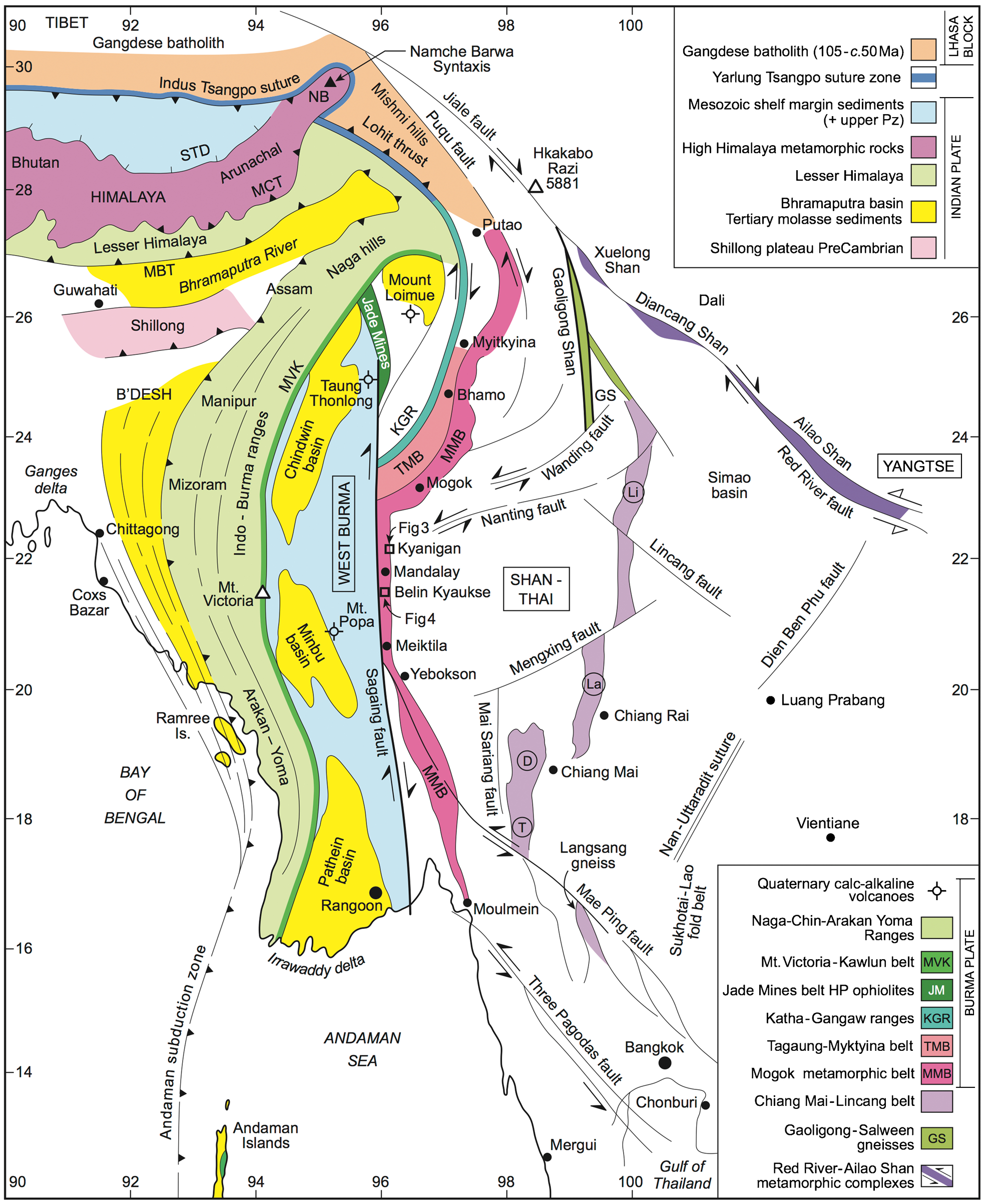
Regional geological map of Myanmar showing the principal tectonic units. From Searle et al. (2007)
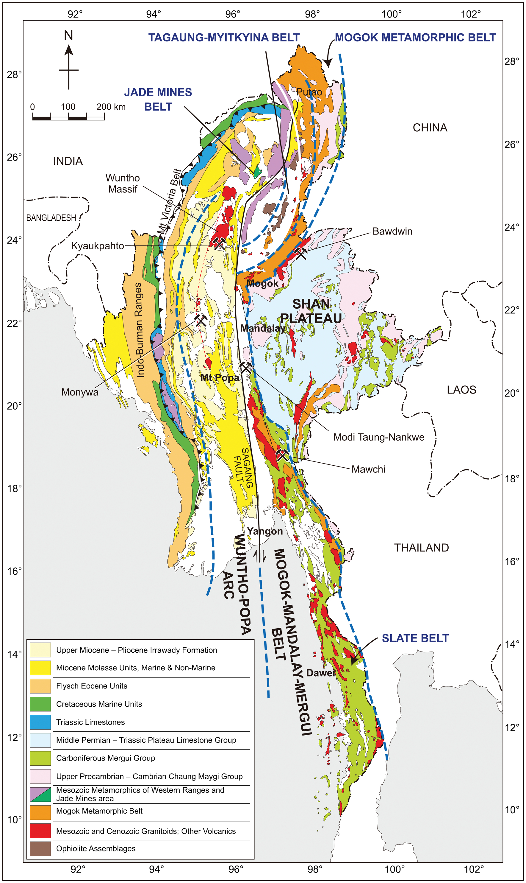
The main metallogenic provinces of Myanmar as referred to in the text. Geological map based on the recently published Myanmar Geosciences Society Geological map of Myanmar (MGS, 2013)
The Sibumasu terrane is correlated with the Qiangtang and Lhasa blocks of Central Tibet in the north, and the western part of the Malay Peninsula to the south (Searle et al., 2007). Within Myanmar, the Sibumasu terrane can be split into two distinct geological and metallogenic provinces either side of the Shan Scarp: the Shan Plateau directly east, and the Mogok-Mandalay-Mergui (MMM) Belt to the west (Fig. 2). The Shan Plateau largely comprises a series of Ordovician-Triassic dominantly carbonate rocks overlying the Precambrian metasedimentary rocks of the Chaung Magyi Group, the Cambrian Pangyun Formation, and associated Bawdwin Volcanics (Mitchell et al., 1977). The MMM Belt can be subdivided into the Slate Belt (Mitchell et al., 2004), running broadly north-south from Mandalay towards Mergui and Phuket, and the Mogok Metamorphic Belt. The Slate Belt represents a predominantly late Palaeozoic succession of pebbly mudstone and wacke, collectively defined as the Mergui Group (Mitchell, 1992). The presence of cool water fossils in these pebbly wackes or diamectites is thought to represent deposition on the margin of Gondwana (Mitchell et al., 2004). The Mogok Metamorphic Belt was originally described by Searle and Haq (1964), but more recently has been the subject of a number of geochemical and geochronological studies (e.g. Barley et al., 2003; Searle et al., 2007; Mitchell et al., 2012). It comprises a high-temperature kyanite-sillimanite grade metamorphic terrane dominated by ruby-hosting, phlogopite- and diopside-bearing marbles, principally outcropping around Mogok, but with occasional pelite and psammite outcrops farther south.
The MMM hosts numerous I-type biotite and S-type two-mica granites of Cretaceous–Palaeogene age (Barley et al., 2003; Mitchell et al., 2012; Gardiner et al., 2014b), and with a continuation into peninsular Thailand these granites form a distinct unit of the Southeast Asian Tin Belts (e.g. Hutchison and Taylor, 1978; Fig. 3); what was once considered the ‘Western Province’ of Cobbing et al. (1986, 1992). Similarly, S-type granites towards the east of the Shan Plateau likely represent a northwards extension of the Central Belt (Khin Zaw, 1990).
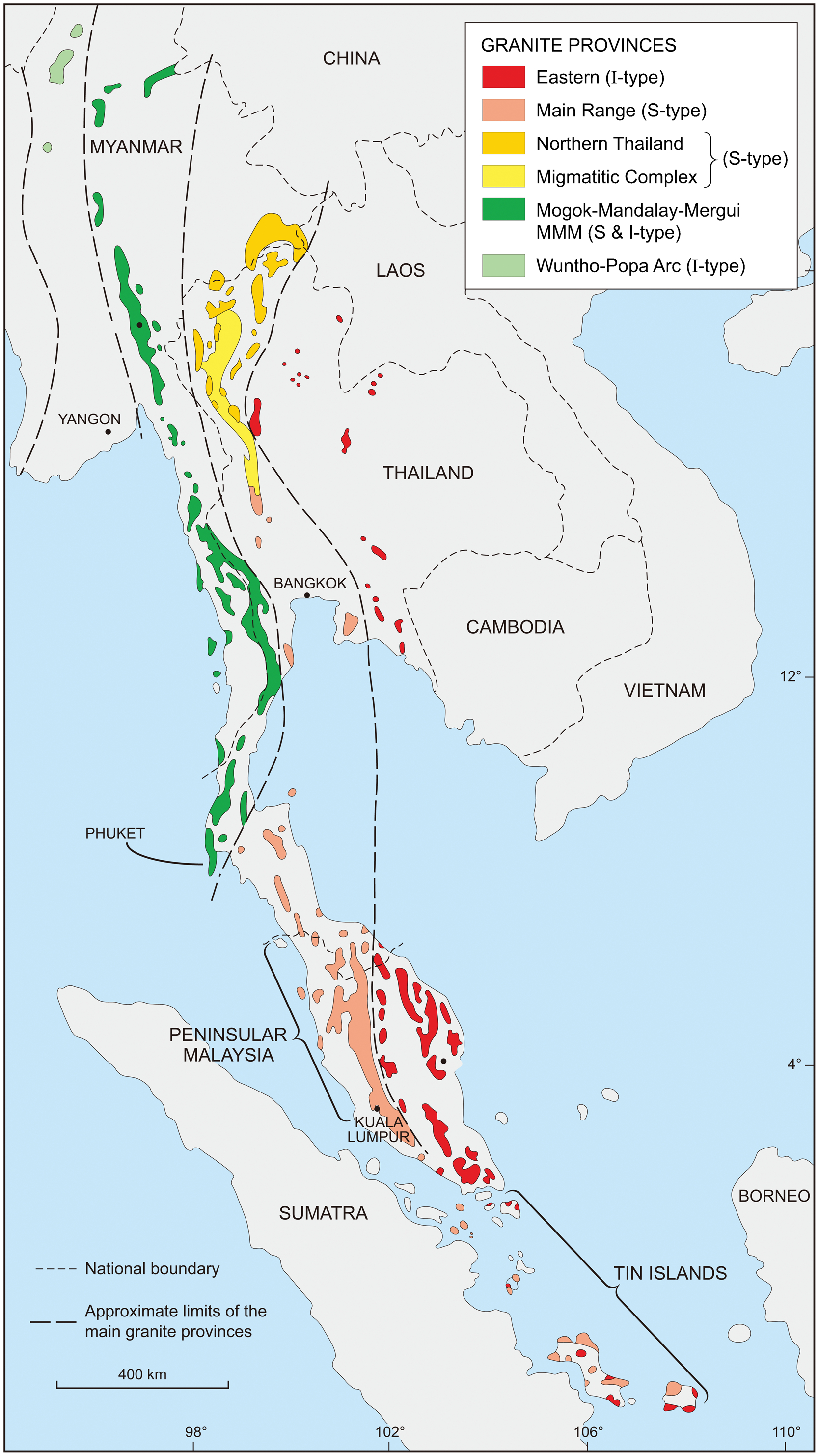
Schematic of the Southeast Asian granite belts – after Cobbing et al. (1986) and Gardiner et al. (2014b)
Myanmar has been variously divided into a number of metallogenic provinces (e.g. Goossens, 1978; United Nations, 1996). Here, we consider the three principal metallotects that collectively contain the majority of base and precious metal deposits of commercial interest, and separately exhibit distinct mineralisation styles, history, and associated commodities: the Wuntho-Popa Arc, the MMM Belt and the Shan Plateau (Fig. 2).
The Mogok-Mandalay-Mergui Belt: Tin, tungsten and gold
The MMM Belt comprises the Slate Belt and the Mogok Metamorphic Belt. The Slate Belt, running broadly north-south from Mandalay towards Myeik (Mergui) and Phuket, is dominated by Carboniferous to early Permian interbedded slaty mudstone and pebbly wacke, with rare quartzite and calcareous beds (Mitchell et al., 2012) all of a few kilometres in thickness. Low-grade metamorphism is locally recognised in biotite schist at Yesin Dam near Tatkon, and also north of Mandalay.
Both hornblende and biotite I-type and two-mica, occasional tourmaline-hosting S-type crustal melt granite punctuate the MMM. The S-type granites, where hosted by the Slate Belt, are associated with significant tin-tungsten mineralisation (Coggin Brown and Heron, 1923; Khin Zaw, 1990; Gardiner et al., 2014b). Extensive, unrelated, orogenic-type gold deposits also occur within the Slate Belt (Mitchell et al., 1999), making this a highly prospective unit.
Tin and tungsten
Tin (Sn) and tungsten (W) are often co-genetic and related to the emplacement of peraluminous granitic rocks that are thought to be derived from the melting of crustal protoliths (the S-type granites of Chappell and White, 1974). A significant proportion of the world's Sn and W resources come from only two areas, of which the Southeast Asian tin granite belts have collectively been the dominant producer, with some 54% of historical Sn production (Schwartz et al., 1995; Robb and Arce, 2014). In Malaysia and Thailand this production was largely derived from industrial-scale river and coastal dredging. In Myanmar there has, however, historically been considerable exploitation of primary resources in addition to alluvial deposits.
Tungsten is now considered a critical metal (e.g. Gunn, 2014), and the supply of such critical metals (also including tantalum, niobium, lithium, and the rare earth elements, [REE]) is an important global concern. These elements are all granitophile in character, and are often spatially and genetically concentrated by processes that also give rise to the major Sn deposits. Historically, these critical metals have not been exploited alongside Sn for a variety of economic reasons, however this pattern may well be changing as exemplified by the recent development of a major W resource (Hemerdon) in the traditional tin-producing region of Cornwall, UK. In Myanmar, critical metal-bearing minerals such as monazite have been recognised within the Sn–W mineralisation (e.g. Garson et al., 1975).
Tin–tungsten mineralisation in the Slate Belt is associated with the intrusion of Cretaceous-Eocene S-type granite (Khin Zaw, 1990; Gardiner et al., 2014b), and within Myanmar well over 100 primary mineral occurrences have been recognised (United Nations, 1996). In a typical deposit, Sn and W are found as varying proportions of cassiterite and wolframite-rich pegmatite bodies and greisen-bordered quartz veins, both within the granite, and intruding the country rock. There is marked regional zoning, with W becoming progressively more dominant over Sn towards the north (Chhibber, 1934).This belt might be referred to as a W province with subsidiary Sn mineralisation (Khin Zaw, 1990). Many occurrences of Sn–W are located in the Dawei (Tavoy) District (Fig. 4a; Coggin Brown and Heron, 1923). At Hermyingyi W–Sn mine near Dawei, more than 300 NS-trending wolframite- and cassiterite-bearing quartz veins crop out for up to 1 km in the cupola of a granite (Fig. 4b; Khin Zaw, 1990). In the Phuket area to the south, Garson et al. (1975) described stanniferous lepidotite pegmatite, and mica-tourmaline pegmatite which also contained significant amounts of wolframite, monazite, and REE- and Yttrium-bearing minerals in association with the cassiterite. A GIS-based pattern of primary outcrops of various commodities in Myanmar shows an obvious clustering of tin-tungsten deposits (in red) in the south of the country (Fig. 5).
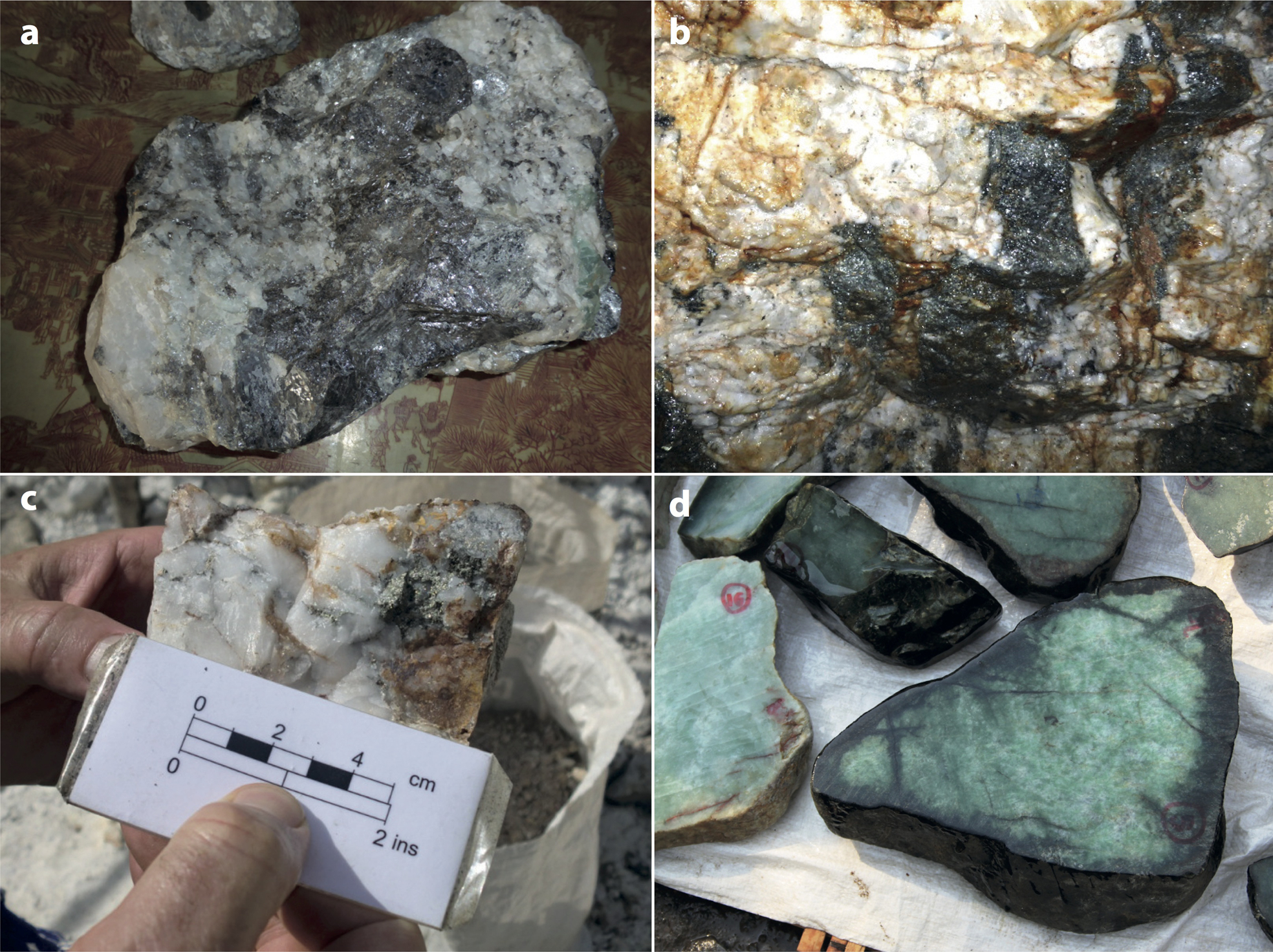
a primary tin–tungsten mineralisation at Bawapin Mine, Dawei District; b in-situ tin–tungsten at Hermyingyi Mine, Dawei District; c example of primary gold in quartz vein, Kyaukpon-Huku Gold District, Mon State; d samples of Kachin State Jade on display at the Mandalay Jade Market. All photos by NJG
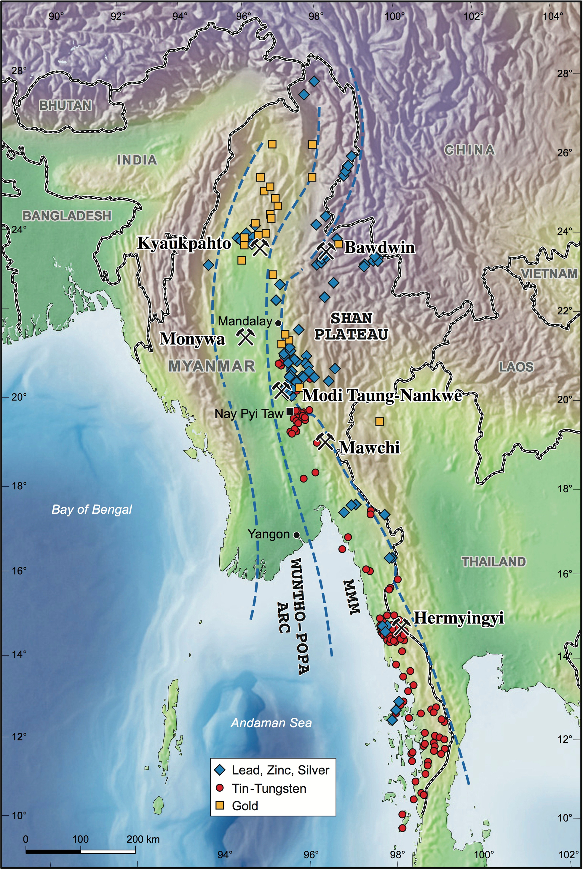
Image based on the Oxford GIS database, showing primary lead–zinc, tin–tungsten and gold deposits and workings in Myanmar, and locations referred to in the text
The Mawchi mine
The Mawchi tin–tungsten mine is located within Karen State, some 250 km northeast of Yangon (Rangoon; Fig. 2). It was once one of the largest global producers of W, accounting for some 60% of total Myanmar W production from 1939 to 1940, the country itself being responsible for some 17% of global W production at that time (Khin Zaw and Khin Myo Thet, 1983).
In the Mawchi district, the Mawchi granite intrudes the metasedimentary rocks of the Slate Belt Mergui Group (Fig. 6). This granite is a relatively small intrusion of porphyritic biotite granite, considered to be a highly fractionated S-type (Khin Zaw, 1990). It was emplaced into the meta-argillite of the Slate Belt, as well as into a prominent limestone roof-pendant that partially overlies the granite cupola. This limestone pendant had acted as a cap to mineralising fluids circulating in fractures within the granite where they formed well-defined veins up to 2·5 m wide. The veins are present to a lesser extent as stockwork in the surrounding Slate Belt metasedimentary rocks (Hobson, 1940; Khin Zaw and Khin Myo Thet, 1983).
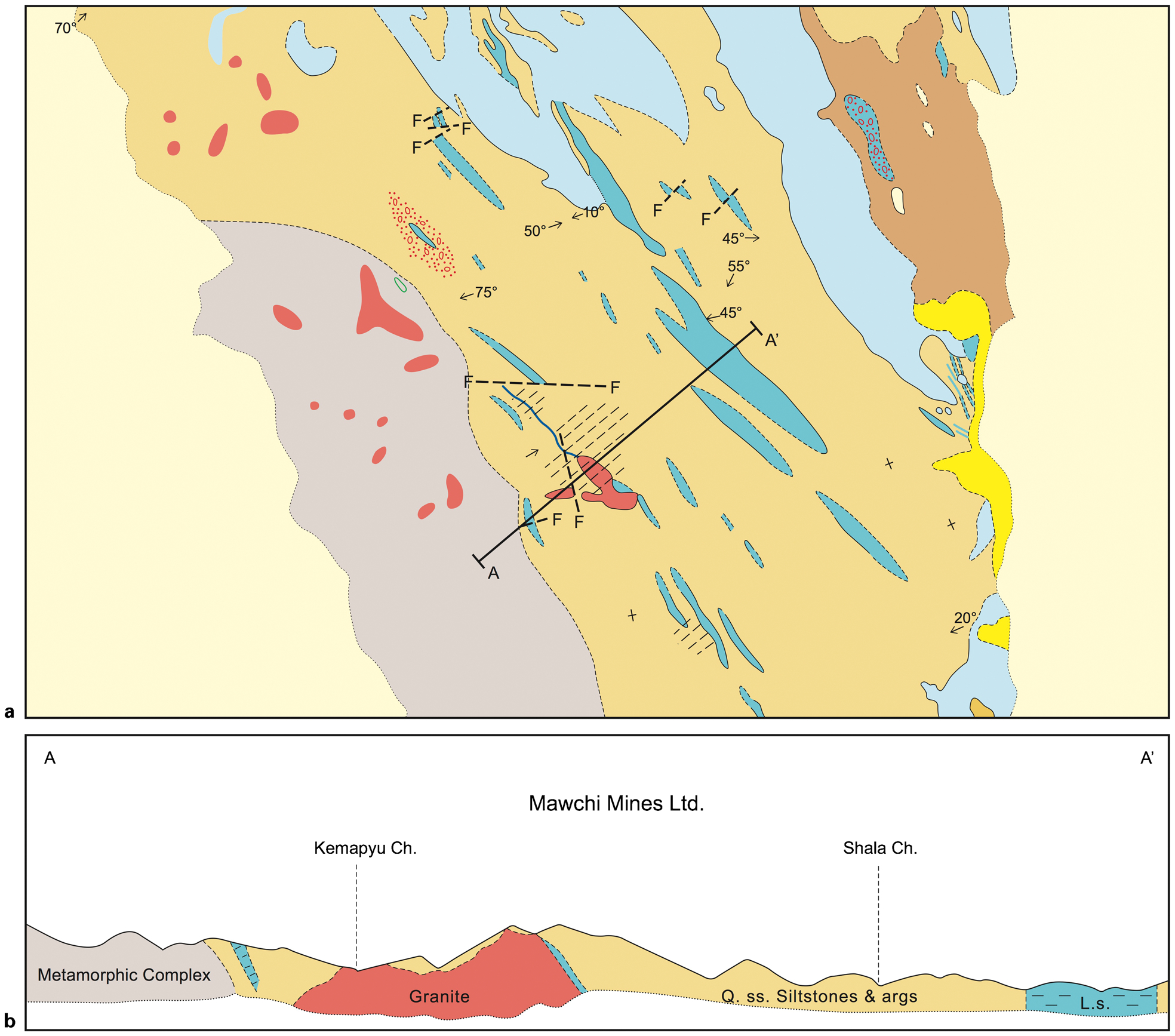
Mawchi district geology: a geological map of the Slate Belt in the Mawchi region; b cross-section A–A’ through the Mawchi granite. From Robb and Arce (2014)
At the Mawchi mine economic Sn–W grades, which decrease with depth, are localised within a granite cupola immediately below a limestone cap, although no skarn or Cornish-style metal zonation are recognised (Hobson, 1940; Robb and Arce, 2014). Although the mineralisation at Mawchi is not significantly zoned, W contents are highest in the lower sections of the mineralised zone, with Sn contents generally increasing upwards at the expense of W. In many Myanmar deposits, W content exceeded that of Sn within the mineralised veins hosted in the Slate Belt country rock (Hobson, 1940), and this would appear to be the case in the Bulawber tungsten workings at Mawchi where veins are contained entirely in the country rock. Mineralised veins comprise an early generation of wolframite and cassiterite, together with paragenetically later molybdenite, bismuthinite, chalcopyrite, arsenopyrite and magnetite. Fluorite is a common gangue mineral particularly in the upper portions of the ore body, whereas topaz and lepidolite, in contrast, are uncommon. Substantial late-stage kaolinite occurs throughout. Some workers have suggested that wolframite precipitated prior to cassiterite for a short interval, and that the two minerals co-precipitated thereafter (Dunn, 1938; Hobson, 1940). Veins typically do not exhibit greissenised margins, but tourmaline is pronounced along vein selvedges and within altered granite. Quartz-tourmaline aggregates within the main mass of granite and well away from veins commonly contain significant cassiterite and wolframite concentrations.
Orogenic gold
Gold (Au) mineralisation has been recognised at numerous localities throughout the Slate Belt (Mitchell et al., 1999), occurring within quartz-pyrite stringers and veinlets (Fig. 4c), and in general is inferred to be of orogenic type (Mitchell et al., 2004). There is no preferential association of Au mineralisation with the Cretaceous-Eocene granite intrusions (Mitchell et al., 1999), textural evidence implying that the Au mineralisation predates their emplacement (Mitchell et al., 2004), although the exact age of mineralisation remains unclear.
Modi Taung-Nankwe gold district
The Modi Taung-Nankwe gold district (Fig. 2) lies within the Slate Belt in central Myanmar (Fig. 7), and measures 25 km long by up to 5 km wide. Here within the Mergui Group, two formations are recognised: the Kogwe Mudstone and the Poklokkale Pebby Wacke, Mineralised veins, hosted by the pebbly mudstone, siltstone and sandstone of the Kogwe Mudstone Group, outcrop at approximately 1300 m elevation (Mitchell et al., 2004). Maximum vein width is some 1·5 m, and almost all veins lie oblique to bedding. The mudstone-hosted veins form well-defined tabular ore bodies, whereas in the sandstone and siltstone they become more dispersed, forming stock-works or sheeted veinlets.

Simplified geological map of the Modi Taung-Nankwe Gold District. From Mitchell et al. (2004)
In the adits developed at Modi Taung-Nankwe during the exploration phase, grade varies from 20 to <2 ppm Au. The high-grade veins were invariably hosted by mudstone, with lower values where the vein enters a sandstone host. In addition to Au, other metals included As, Ag, Bi, Cr and Cd. Sulphides were also present, including pyrite, arsenopyrite, galena, and rarer sphalerite and chalcopyrite; high Au values were associated with pyrite. The poorly constrained age of the Modi Taung-Nankwe mineralisation has been stratigraphically bracketed between late Permian and mid Jurassic (Mitchell et al., 2004).
Gold mineralisation hosted within marble, and associated with the intrusion of Cretaceous I-type granite, is found at several localities within the Mogok Metamorphic Belt. The Shante gold belt, some 50 km south of Mogok, is a 500 km2 district comprising high-T phlogopite-bearing marble which hosts occasional quartz veins with gold and associated base metal (Zn and Pb) sulphides.
The Shan Plateau: Lead, zinc, silver
The Shan Plateau in eastern Myanmar (Fig. 2) largely comprises Ordovician-Triassic carbonate rocks which overlie the Precambrian metasedimentary rocks of the Chaung Magyi Group, the Cambrian Pangyun Formation and the associated Cambro-Ordovician Bawdwin Volcanics (Mitchell et al., 1977). In addition, S-type granite plutons, which outcrop towards the centre and east of the Shan Plateau, are interpreted as a northwards extension of the Central Province of Cobbing et al. (1992), running through Thailand and Malaysia. In places these granites host tin mineralisation (U Kyi Htun, pers. comm.., 2013). A number of known lead–zinc mines within the Shan Plateau lie in a broad NE–SW orientated belt extending from the Shan Scarp up to the Chinese border (Fig. 5). The Bawdwin mine represents the most significant of these deposits.
The Bawdwin Mine
The Bawdwin Mine and Namtu smelter complex are located in the Northern Shan States, 80 km from the border of mainland China, and 60 km northwest of Lashio (Fig. 2). Artisanal Chinese silver (Ag) mines date from the 1400s. In the early twentieth century the British noticed that the slag dumps resulting from the silver workings were extremely lead-rich, and the Burma Mines Corporation was formed to properly develop the resource as a Pb–Zn producer. Prior to World War II the Bawdwin Mine was the world's largest producer of Pb, and one of the largest producers of Ag. In addition, Zn and Ni were also mined. By the late 1960s it was estimated that there was still some 6 million tons of available ore at 11% Pb, 5·6% Zn and 7·8 oz/t Ag (United Nations, 1966).
Whereas many 1980s workers classified the Bawdwin deposit as Kuroko style (Brinckmann and Hinze, 1981; Hopwood, 1985), more recent genetic models include a siliciclastic-felsic volcanogenic massive sulphide-type classification (Gardiner et al., 2014a). Bawdwin consists of three principal massive sulphide lodes dipping 70° W to vertical with a vertical extent of at least 500 m, and a horizontal strike length of 1500 m. Host rocks comprise the Cambro-Ordovician metasedimentary rocks of the Pangyun Formation, and tuffs and rhyolites of the Bawdwin Volcanics (see Fig. 8). The tuffs and Pangyun sedimentary rocks are intercalated, implying they were co-depositional. The massive sulphide mineralisation at Bawdwin is principally hosted by the tuffs and rhyolites, and as textural evidence suggests this mineralisation is related both spatially and temporally to the Bawdwin Volcanics, it is therefore dated at Cambro-Ordovician by the association of the Bawdwin Volcanics with the Pangyun sedimentary rocks.
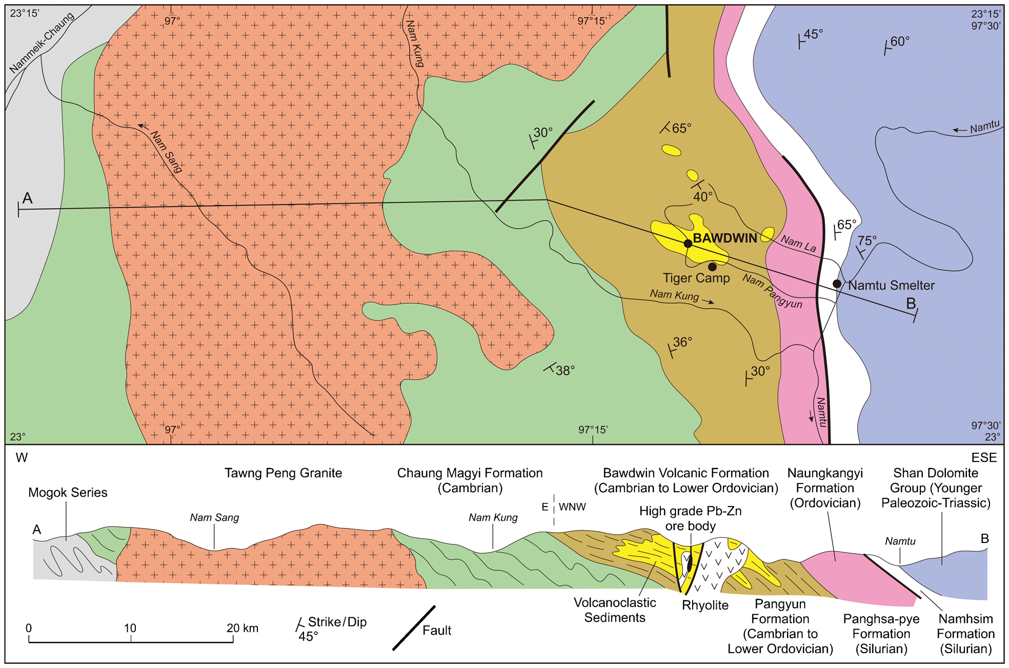
Schematic cross-section of the Northern Shan States and the Bawdwin Deposit. From Gardiner et al. (2014a), after Mitchell et al. (1977)
The mineralisation zone at Bawdwin is cut by two principal cross-faults (the Yunnan and the Hsenwi). These are both now considered to be post-mineralisation, and interpreted to have separated a single ore body into the three lodes recognised today (Gardiner et al., 2014a). Later regional tilting is assumed to be responsible for the steep inclination of the ore bodies. Mineralisation at Bawdwin comprises dominantly galena-sphalerite with elevated Ag, and low grade Cu-bearing footwall stockwork.
Other lead–zinc deposits in the Shan Plateau
The isolated nature of the Bawdwin volcanogenic massive sulphide-style mineralisation is anomalous in Myanmar, although other Pb–Zn mines are recognised in the Shan Plateau. The Yadana Theingi Mine, some 50 km south of Bawdwin, hosts galena-barite ores within a NW-striking shear zone, interpreted as Mississippi Valley type mineralisation. The Bawsaing (or Theingon) mine, sited near HeHo in the southern Shan States, is a Pb–Zn–Ag deposit, and is considered to be a stratabound, carbonate-hosted Mississippi Valley type deposit (Khin Zaw et al., 1993). The Moho Chaung mine is sited 50 km northeast of Bawdwin, and is a sandstone-hosted Pb–Zn–Ag deposit, i.e. likely to be a SEDEX deposit.
The Wuntho-Popa arc: Copper and gold
The west-facing Wuntho-Popa magmatic arc (Fig. 2) in western Myanmar represents a discontinuous belt of both intrusive and volcanic rocks extending 500 km northwards from Mount Popa in central Myanmar, and exposes a number of inliers surrounded by Miocene-Recent sedimentary cover. The two principal inliers are the northerly 160 km-long Wuntho-Banmauk segment, and the Monywa-Salingyi segment in central-south Myanmar. Both inliers show similar geology: a marine sequence of limestones, mudstones and pillow basalts intruded by Mesozoic–Cenozoic granodiorite plutons, smaller calc-alkaline intrusions and with later Pliocene volcanic rocks. The metaluminous chemistry of the granite, the presence of magnetite, and the existence of porphyry-type Cu–Au and epithermal Au deposits, all imply dominantly I-type subduction-related granites (Khin Zaw, 1990; Mitchell et al., 2012). The Wuntho-Popa Arc is underlain by the Burma Seismic Zone, and the observed calc-alkaline magmatism is suggestive of an Andean-type setting.
Chhibber (1934) documented metallogenic deposits in the vicinity of the Wuntho-Popa Arc, describing a number of base metal and gold occurrences. In the early 1970s, the Wuntho-Popa Arc was recognised as a volcanic setting (United Nations, 1978), leading to a re-evaluation of the possibility of epithermal and porphyry-type mineralisation. In the late 1990s it was considered that two types of mineralisation prevailed within the Wuntho-Popa Arc: porphyry Cu–Mo, and epithermal-polymetallic Au–Cu–Ag (United Nations, 1996); however since then several other settings have been recognised.
Mineralisation in the Wuntho-Popa Arc is confined to two principal districts: Monywa towards the south, and the Wuntho-Banmauk inlier farther north (Fig. 2). Historically, most Au production in the region has been from Late Cretaceous high-grade auriferous veins found both in granodiorite and surrounding host rocks, and from derived placers in the Wuntho region (Chhibber, 1934). Au mineralisation is also recognised within the Tagaung-Myitkyina Belt lying farther north in Kachin State, and interpreted as a possible extension to the Wuntho-Popa Arc (Mitchell et al., 1999). Porphyry Cu–Au prospects have been recognised at Shangalon near Wuntho (United Nations, 1996; Mitchell et al., 2011). Mesothermal sediment-hosted Au workings at Kyaukpahto are likely to be genetically related to movement on the Sagaing Fault.
Wuntho district gold mineralisation
Gold mineralisation in the Wuntho district is largely confined to the Banmauk-Wuntho inlier. Here, it is found principally as Au-bearing quartz or quartz-carbonate veins, which are exploited in small scale mines at Au grades of 20–100 g/t Au (Mitchell et al., 1999), and lie within the Late Cretaceous granodiorite locally extending into the schist and volcanic country rocks (United Nations, 1978; Khin Zaw, 1990; Mitchell et al., 2012).
Similar Au veins are also found farther north in the Mabein District, within the Tagaung-Myitkyina Belt, and here Mitchell et al. (1999) make reference to epithermal Au-bearing veins found within strongly silicified host rocks of Upper Oligocene-Lower Miocene mudstone and sandstone. Low sulphidation epithermal Au quartz veins are also reported from south of Shangalon (United Nations, 1996).
Kyaukpahto gold mine
The Kyaukpahto gold mine is possibly the largest producing Au mine in Myanmar, and is sited in Kawlin Township, northern Myanmar (Fig. 2). The mineralisation is not strictly related to magmatism in the Wuntho-Popa Arc, but instead is strongly associated with a system of extensional faulting. NNE-trending extensional faults formed by a component of dextral strike-slip movement on the Sagaing Fault (Ye Myint Swe et al., 2004) host stockwork epithermal Au mineralisation developed within the Wuntho-Popa Arc. Veins with pyrite, chalcopyrite and arsenopyrite are best developed in competent silicified sandstone locally extending into the adjacent mudstone of the Lower-Mid Eocene Male Formation (Mitchell et al., 1999). These host rocks have undergone intense hydrothermal alteration including silicification which appears to be critical for the genesis of the veining. Veins are generally confined to silicified sandstone, although they are rarely present in the mudstone.
Monywa copper mine
At the Monywa copper mine, near Monywa within the Wuntho-Popa Arc in central-western Myanmar (Fig. 2), high sulphidation epithermal mineralisation is inferred to be underlain by a mid-Miocene pluton (Mitchell et al., 2011). Two of the recognised four major deposits which provided a resource of 2 billion tonnes of 0·26% Cu are in active production at the time of writing (Sabetaung and Sabetaung South), thereby providing Monywa world-class status, eclipsed as a Cu deposit in Southeast Asia only by the Grasberg mine in Indonesia, and by the Tampakan high sulphidation Cu–Ag deposit in the Philippines (e.g. Middleton et al., 2004).
Prominent topographic highs define the essentially barren oxidised leached caps which are up to 200 m in thickness. These overlie transition and hypogene copper sulphide ore hosted by andesite dykes and sills, which intrude the sandstone and pyroclastic rocks of the Magyigon Formation (Fig. 9). Synchronous uplift and erosion are interpreted to have promoted the development of a supergene enriched zone to a depth of 200 m which hosts 75% of the Cu resource. Cu grades decrease with depth from just below the base of the oxidised zone, and within the leached caps Cu values of 150 ppm and below reflect a high pyrite to Cu ratio. Monywa therefore exhibits a highly efficient supergene leaching process, which has been explained by the unusually high pyrite content, uninterrupted uplift, and the consistent equilibrium with the water table (Mitchell et al., 2011).
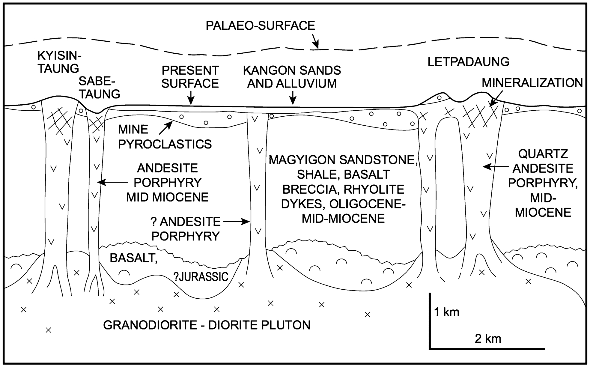
Schematic northwest-southeast section through the Monywa copper mine district. This shows speculative geology at depth, and possible intrusions. Taken from Mitchell et al. (2011)
Whereas the main hypogene ore minerals found at Monywa are digenite-chalcocite, covellite and minor enargite, typical of high-suphidation epithermal deposits, Monywa differs from many other high sulphidation deposits in the absence of associated economic Au grades, and in the scarcity of large bodies of replacement quartz. This lack of Au is thought to be the result of exposure of a deep epithermal system in which hypogene Cu minerals were not necessarily overlain by Au mineralisation (Kyaw Win and Kirwin, 1998).
Other metallogenic provinces
Gemstones and Jade
Myanmar is an important producer of quality rubies, sapphires and jade. Rubies are largely found within the Mogok Stone Tract (Chhibber, 1934), close to Mogok itself (Fig. 2). Rubies are hosted within high temperature (ruby) corundum-phlogopite-bearing marbles of the Mogok Metamorphic Belt, formed by collision-related metamorphism (Searle et al., 2007), and are extracted from concentrations within byons, or thick lateritic soil horizons (Waltham, 1999), which at Mogok are usually 5–6 m below the valley surface, and between 1–2 m thick (Keller, 1983). In addition to the ruby marbles, alkaline intrusive rocks, principally nepheline syenites, are common throughout the Mogok region (Iyer, 1953), and they contain gem-quality sapphires. These sapphires are thought to be the result of crustal contamination and partial melting of lower crust during high-temperature intra-continental alkaline magmatism.
In the north, three metamorphic belts splay off of the Sagaing Fault; the western-most one is the Jade Mines Belt in Kachin state (Fig. 2). This is a high-pressure metamorphic belt of ultramafic material, thought to be a relic ophiolite. Here, mantle-derived harzburgite and lherzolite have high-pressure jadeitite mineralogy associated with peridotite and with rare eclogite. This belt was mapped in detail by both Chhibber (1934) and Iyer (1953), but since then has been largely off-limits to western geologists and not studied further. Due to accessibility issues, much of the mined Myanmar Jade is sourced as boulders in young river gravels along the banks of the Uru River near Hpakan (Fig. 4d).
Chromium and platinum group minerals are found associated with ophiolite complexes in Kachin State (Soe Win and Marlar Myo Myint, 1998). There are two principal nickel laterite deposits in Myanmar; Mwetaung in the Chin Hills to the west, and Tagaung Taung near Mandalay (Chhibber, 1934; Soe Win and Marlar Myo Myint, 1998).
The current minerals industry in Myanmar
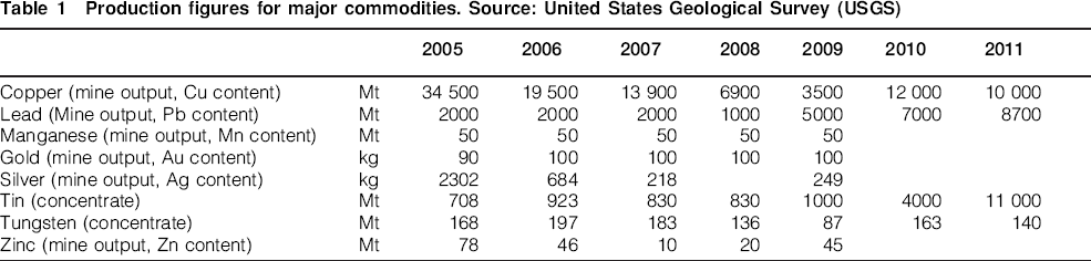
The current mining industry in Myanmar was worth $62m (USD) in 2010 (ICMM, 2012), against a 2012 gross domestic product of $53Billion (CIA, 2013); mining therefore currently contributes some 0·1% to Myanmar's domestic gross domestic product. Given the country's extraordinary wealth in natural resources, this represents an industry that is currently hugely underdeveloped. Recent production figures for major commodities are given in Table 1. At the time of writing, a new mining law is under preparation.
Production figures for major commodities. Source: United States Geological Survey (USGS)
Summary
Myanmar as a minerals jurisdiction comprises one of the most diverse and richly endowed collections of natural resources in Southeast Asia, and as a country retains huge potential for the growth of its mining industry – both through the rehabilitation of old workings, and by the discovery of new ore deposits. The country is slowly opening up both politically and economically, and, despite expected and ongoing challenges with regards to the operating environment, it is now timely for industry and academics alike to start to revisit Myanmar as an exciting emerging minerals jurisdiction.
Footnotes
Acknowledgements
Raphael Martin of Dark Capital is acknowledged for financial support of the Myanmar project. The authors thank Andrew Mitchell for numerous conversations. U Htun Lynn Shein of Myanma Precious Resources Group is thanked for assistance and access. Dave Sansom is acknowledged for drafting. Greg Corbett and an anonymous reviewer are thanked for their inputs during the review process to help improve the manuscript. Finally, I am indebted to a number of consulting Myanmar geologists for their interest, assistance and advice, including: U Myint Thein Htay, U Aung Tin, U Kyi Htun, U Nyunt Htay and U Kyaing Sein.