
Abstract
To assess common factors and the key exploration methods in gold discovery we analyse 154 case studies of successful gold exploration. Our aim is to highlight what may help find gold in the future. The case studies used here are only those documented in the consistent series of biennial volumes of New Generation Gold from 1995 to 2013. Surface and near surface sampling dominate early phases of exploration. Subsequently, as a second and third priority drilling, initially rotary air blast or air-core and then reverse circulation and diamond core drilling dominate exploration. The priority order of methods is more or less the order of access from surface. However, some discoveries document reverse circulation or diamond core drilling as the first and primary method suggesting success by bold targeting and early drilling. Gold has no direct recognisable geophysical signature but geophysics is used as an indirect tool to model the geology and weathering. Geophysical methods, be they magnetic or electrical methods, maintain a similar level of interest throughout programmes. Alteration science is recorded as a method in only 13% of discoveries, a comment that may seem at odds with the modern focus on hyperspectral mapping and logging. Similarly and despite being unambiguously the principal control on gold mineralisation, structure is recorded as of use in only 53% of discoveries, usually a 3rd or 4th priority. Of the case studies, 16% make no mention of structure at all. It is surprising that when surface outcrop is available, structural geology is rarely documented as an exploration method. The low levels of reporting of the intellectual activities of alteration and structural geology (and to a lesser extent mapping and geophysics) suggests they are (i) under-reported or, (ii) that current science is inadequate (this is unlikely) or, (iii) they are under-utilised. If under-reported, are the senior managers and directors who wrote these papers aware of the intellectual effort of their teams? Alternatively if under-used, alteration and structure may represent a significant opportunity for the next generation of exploration.
Introduction
The important elements of exploration success are area selection, appropriate exploration technologies and models, and skilled and motivated people (Phillips, 2011). For each successful prospect that will develop into a mine, many more prospects will be abandoned without further development. This paper is a critical analysis of technological methods used in 154 case studies of successful gold exploration from the early 1990s to present. The purpose of the study is to investigate major gold discoveries over the last two decades. Specifically, we ask which exploration methods brought success for each discovery? Are there any common factors, key exploration methods or gaps in technology utilisation that may help find gold in the future?
A consistent source of discovery information is the New Generation Gold Conference series (also known as NewGenGold), which details major case discoveries every two years from 1995 to present (Yates, 1995, 1997, 1999, 2001, 2003, 2005, 2007, 2009, 2011, 2013). Early volumes in the series are biased towards discoveries in Australia, but later New Generation Gold examples focus on the discovery case histories of the world's most recent or future gold mines, and address consistently the ‘why, where and how’ of the process leading to each discovery. These volumes cover many discoveries including some in China, but not all discoveries. There is undoubtedly a bias towards English-speaking companies. There are for instance no discoveries documented from Russia. Also some Australasian discoveries such as Favona (New Zealand) are not documented. The 14–16 discoveries highlighted in each biennial NewGenGold Conference are here presented in a series of global maps as time slices (Fig. 1). The deposits are of all ages from Archaean to Cenozoic (Fig. 2). No other sources were used in this study, limiting bias to that intrinsic to the NewGenGold selection criteria.
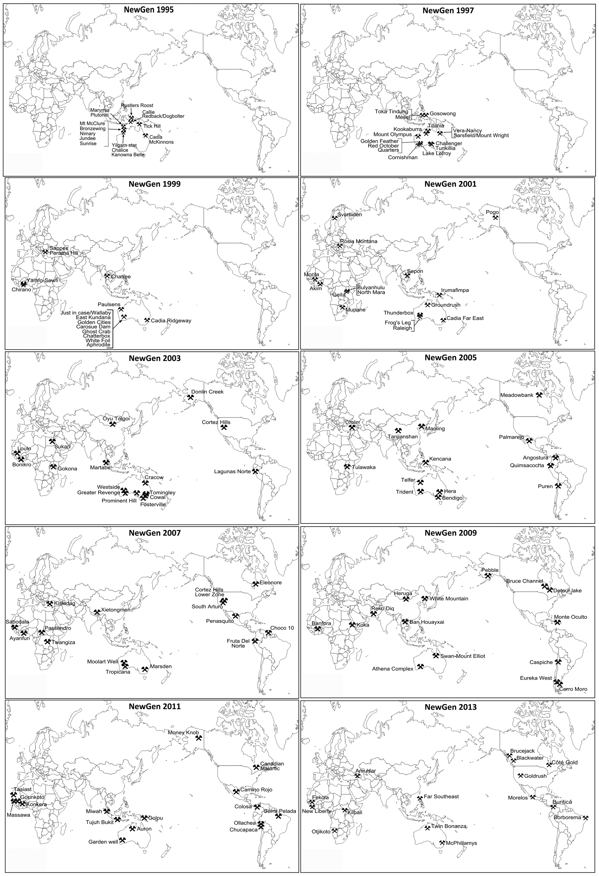
Maps showing the gold discovery locations from each of the NewGenGold Conference series
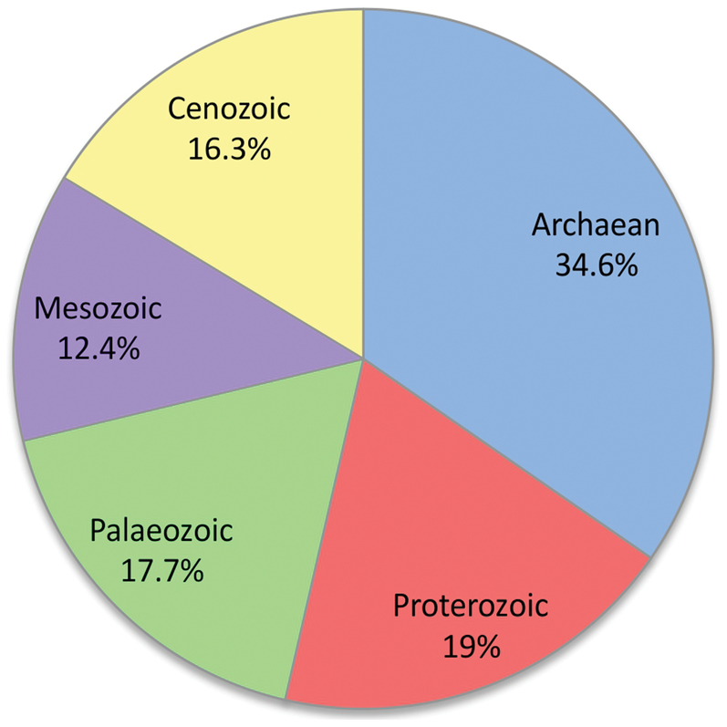
Age of deposits reported in the NewGenGold conference series 1995 to 2013. If age of mineralisation is not given we here record the age of the host rocks
In most cases the NewGenGold Conference series papers were written by Directors and Senior Managers, one to two years after initial discovery. While it is possible that the geologists on the ground held different views, senior staff with corporate power and influence wrote the papers. For a couple of discoveries, the papers were authored by senior staff in companies that had acquired the project after discovery, for example the Plutonic discovery (Bucknell, 1995), but for the most part authorship is by those who oversaw the exploration process.
To minimise bias, no discovery case studies have been considered except those in the NewGenGold conference series. The NewGenGold series is the only source we know where Senior Management is writing the discovery reports to a consistent style and from a semi-consistent perspective. Allowing case studies outside this source would include reports written by various staff members or consultants involved at different exploration phases, and hence may put emphasis on selected exploration methods rather than the whole discovery process. Restricting ourselves to the NewGenGold series comes with the important caveat of no reporting prior to 1995, and that the reports are strongly biased to Australia prior to 1999.
Exploration methods can depend on whether exploration is brownfields or greenfields. In these case studies the vast majority of deposits are greenfield discoveries. However a number are brownfields (Westside, Hall et al., 2003; Telfer, Howard et al., 2005) and some are unclear due to the way the case history has been written.
Methodology
We take a systematic approach in analysing all 154 discoveries described in the New Generation Gold volumes 1995 to present. For each case study, we determine a priority numbering system applied to the most successful technical exploration method for each discovery, with 1 being first and most successful, and consecutive numbers (2, 3, 4) assigned to the relative importance of subsequent exploration work. Rarely does a case study describe more than four methods. The order of priority for exploration methods was determined by the case study statements of importance in the discovery. If exploration methods were described but not prioritised, then the order of presentation in the case study publication is recorded.
The results are analysed critically to find trends or differences over the last two decades, or if any particular exploration method has been consistently successful in finding discoveries. There are a few cases where the exploration methods cannot be neatly specified as the authors do not make clear which was of more importance, e.g. geological mapping providing structural data. In such cases, both methods are allocated the same priority number. Our detailed analysis is available as a large spread sheet (Supplementary Material 1 http://dx.doi.org/10.1179/1743275814Y.0000000050.S1) available for download from www.sjsresource.com.au. Pie charts show methods used in successful exploration in priority order (Fig. 3). The order of methods presented within each pie chart is more or less in the order of access from surface.
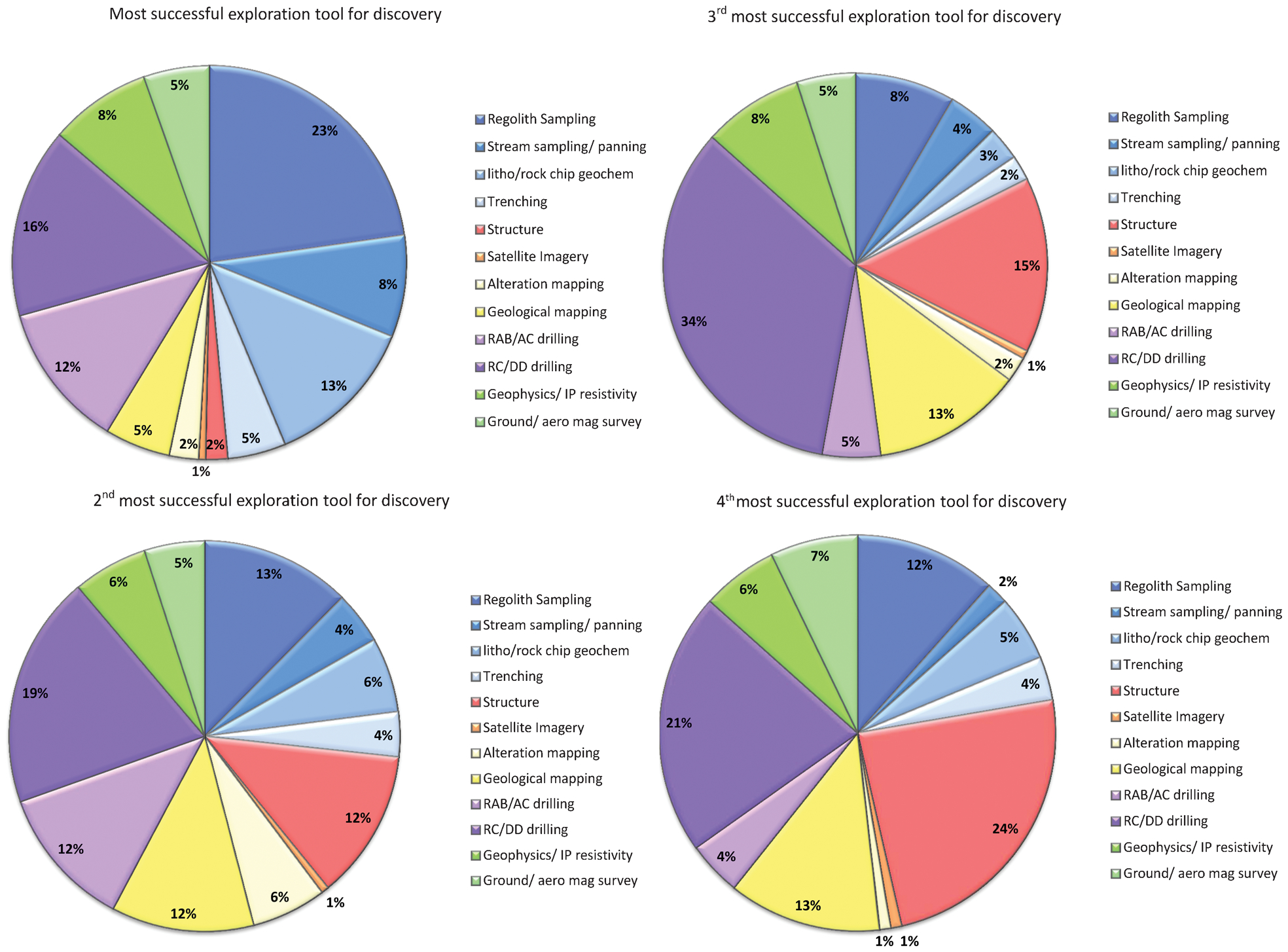
Pie chart diagrams showing exploration method according to priority in each case study, priority 1 being first, priority 2 second, priority 3 third and priority 4 fourth
What exploration methods are successful for discovery?
This study quantifies the methods documented in successful exploration case studies. Most of the results are not a surprise, although we identify some methods (below) that appear to be under-used or under-reported. Re-assessing previously extensively explored terranes with modern exploration techniques (e.g. the Canadian Malartic Mine, Wares and Burzynski, 2011) and having the confidence to drill deep (e.g. Vera-Nancy discovery, Kay and McKay, 1997) has been noted as a recurring theme in these case studies (Phillips, 2011) but persistence is not documented here as a method itself.
Surface and near surface sampling (stream and regolith sampling, rock chips and trenching) dominate early phases of exploration and appear to be the major discovery technique, i.e. priority 1, with 49% of deposits being discovered by these methods (Fig. 3). Regolith sampling is effective in Australia and stream sampling (8% priority 1) effective for mostly non-Australian discoveries. Two Australian exceptions are McKinnons (Elliott, 1995) and Mount Olympus (Morant and Doepel, 1997) where stream sediment sampling had a major role. The national difference between regolith sampling and stream sediment sampling is a reflection of Australia's Cenozoic history of southwards drift away from the tropics, climate change and lack of tectonism, contrasting with the more active terrains with Cenozoic exhumation by stream and river systems in most of the world.
Subsequently, as a second and third priority, drilling, initially rotary air blast or air core and then reverse circulation and diamond core drilling dominate exploration. However, 16% of discoveries quote reverse circulation or diamond core drilling as the first and primary method suggesting success by bold geological targeting and early drilling.
A number of case studies mention geological mapping as a high and early priority with 5% of studies referencing the surface map as the number one priority. However, for the most part geological mapping appears as a lower order priority conducted after the discovery of significant gold anomalism.
Geophysics
Gold has no direct recognisable geophysical signature (Doyle, 1990) but geophysics is used as an indirect tool to model the geology, alteration and weathering. Interestingly, geophysical methods, be they magnetic or electrical methods maintain a similar level of interest through programmes.
Some examples where geophysics has been used in tandem with structure include Marymia (Kennedy, 1995), Cortez Hills (Hays and Thompson, 2003), Tomingley (Chalmers et al., 2003), Chatterbox (Johnson, 1999), Frog's Leg (Heeroma et al., 2001), Thunderbox (Bennett et al., 2001), Cracow (Creenaune et al., 2003), St. Ives Athena complex (Briggs et al., 2009), Gounkoto (Harbidge and Holliday, 2011), Moolart Well (Balkau et al., 2007), Banfora (Brooks and Cameron, 2009) and Ghost Crab (Miller and McLeod, 1999). All, with the exception of Cortez Hill (Nevada), Banfora (Burkino Faso) and Gounkoto (Mali), are in Australia. The structural interpretation for all of these deposits was done based on detailed geophysics, with airborne magnetics most commonly used. With the exception of Banfora and Ghost Crab, geophysics defined major structural features and trends that were previously unknown in the deposit areas, particularly when a deposit was blind.
Marymia, Cortez Hills and Tomingley deposits all had surface outcrop; however, geophysics was used to understand particularly complex structures and project structures to depth. Despite outcrop being present, geophysics was regarded as a higher priority exploration method than either structure or geological mapping.
Chatterbox, Frog's Leg, Thunderbox, Cracow, St. Ives Athena Complex, Gounkoto and Moolart Well are all blind deposits with thick regolith, or with little to no outcrop, and poor geochemical response with conventional surface sampling techniques. In these cases, geophysics was regarded as a high priority particularly when planning drill hole targets.
At Banfora, the main structural corridors were already known, however geophysics helped the geological team have a better understanding of the complexities in the area, highlighting smaller shears within the structural corridor leading to the identification of new and successful drill targets (Brooks and Cameron, 2009).
Ghost Crab is an example of a discovery where although the regional structural geology was well-known, drilling results targeting these structures were generally disappointing. Application of aeromagnetic data caused a re-evaluation of the major structural features which control gold mineralisation in the Norseman-Wiluna Belt, and highlighted several under-explored dilational sites (Miller and McLeod, 1999).
Alteration mapping
Alteration studies, including mapping appear to play a minor role in gold exploration success. All types of gold deposit (except placers) have significant recognisable alteration, and academic papers consistently write up alteration as a gradient to ore in both Archaean lode gold and Phanerozoic epithermal-porphyry domains (Eilu et al., 1999; Seedorff et al., 2005; Simmons et al., 2005). Whereas alteration science has played a critical role in some discoveries, including Cadia (Wood and Holliday, 1995) and Golpu (Hayward et al., 2011), for about 87% of the case studies alteration is not recorded as a method used, a comment that may seem at odds with the booming industry in hyper-spectral mapping and logging of the past decade. Alteration science appears either under-utilised or under-documented in gold exploration.
Structure in exploration
Structure is unambiguously the principal control on gold mineralisation, (Conolly, 1936; McKinstry, 1948; Groves et al., 1988, Colvine 1988; Kerrich and Feng, 1992; Vearncombe, 1998). Given the role of structure in the control on gold, and the recent focus on structurally related exploration technologies (pmd*CRC, 2007–08) it may be expected that structure would play a critical role in successful exploration. The opposite is the case. Only 82 (53%) out of 154 discoveries are documented as being found using structural geology at some point during the discovery phase (usually priority 3 or 4). This includes deposits where regional structure was known from earlier (mostly government survey) work.
Three deposit case studies indicate structure as the most significant exploration tool for discovery: Lake Lefroy, Centenary and North Mara. Interestingly, Lake Lefroy near Kambalda Western Australia, is a salt lake with zero outcrop and surface materials that do not reflect bedrock chemistry (Reddell and Dusci, 1997). Structural geology in critical combination with magnetic data targeted the Lake Lefroy deposits. Detailed stratigraphic and structural interpretation of the Archaean geology in the Lake Lefroy area was compiled at 1∶25 000 scale over a 10 km wide strip between Kambalda and St. Ives. This interpretation relied heavily on data collected from previous nickel exploration, using re-examined drill results and ground magnetics. NNW–NNE orientated structures hosted gold mineralisation, with drilling planned to intersect these structures (Reddell and Dusci, 1997).
Centenary is a discovery adjacent to the Darlot mine, and used the known structure at the Darlot mine to define nearby targets, following the model of nearby mine Bronzewing where Western Zone is separate to and adjacent to the main lode Central Zone (Bucknell, 1997; Gebre-Mariam et al., 2000). Centenary was discovered by drilling just 1·2 km east of the existing Darlot gold mine, with the drill holes targeted at known structures. Drilling intersected gold grade, with the gold mineralisation hosted within quartz veins along a NNW striking south-west dipping thrust fault, and is located on the western limb of a regional north-west plunging syncline. The Centenary ore body is best developed where its controlling structure intersects the central unit of the layered dolerite sill (Bucknell, 1997).
At North Mara surface geological and structural mapping provided constraints on the orientation of mineralisation and alteration, and was the principal driver of exploration targeting. Through this drill targeting, mineralisation was observed to occur along specific segments of a more extensive fault array. Micro-structural analysis was then carried out, with the relationships between alteration, mineralisation and structure recognised and used towards a structural targeting strategy. This strategy also required an understanding of the timing, kinematics during mineralisation, and the geometry of those structures active during mineralisation, separated from older and younger features (Stewart et al., 2001).
Forty six (29%) of 154 discoveries mention structural geology for the purpose of the regional geological setting but make no reference or give any evidence for structure being used as a discovery tool. Also included within this 29% are the deposits where structural geology was carried out, but only after the discovery was found to define the resource. Twenty six studies (16%) of 154 case studies make no mention of structure at all. Nineteen (12%) of the 154 case studies have surface outcrop available, but make no mention of structural geology at all, even when rock chip sampling has been regarded as a high priority.
The authors of the case studies clearly regard structure as subordinate to regolith or stream sampling, drilling of all types and even geophysics, having a significant impact at only the third or fourth priority (Fig. 3). Structure is used to help generate drill targets when there is thick regolith, little outcrop and geophysics is used to pick structures. What is surprising is that when outcrop is available, structural geology is not documented as one of the prevailing exploration tools and in some cases is not considered until geophysics has been carried-out, if considered at all.
Perception or real?
The low levels of reporting of alteration science and structural geology (and to a lesser extent geophysics) leave us asking if the NewGenGold case studies fairly reflect the intellectual effort in a discovery. As an example, everyone uses rock type, and it commonly shows a bias to dolerite and banded-iron formations during gold discovery, yet it fails to register in the priorities. The preferred success method that we record here is the perception of the discovery author(s). Few authors document background science or eureka moments, because they may not be able to explain exactly what a team did. It is easier to list the methods in a manner similar to the categories in an accounting package.
In the case of alteration and structure there is a substantial academic literature record, hundreds of millions of dollars have been spent on researching the topics and there is no reason to believe that the science is backwards. However, these topics appear as academic pursuits and are not readily achieved by large data collection teams. They are rarely seen as industry–friendly or early exploration methods.
Conclusions
There are few surprises in the analysis of 154 case studies of successful gold exploration written in the series of NewGenGold biennial volumes focusing on the ‘why, where and how’ of the process leading to each discovery. As expected, surface and near surface sampling (stream and regolith sampling, rock chips and trenching) dominate early phases of exploration with the choice of sampling method dependent on continent (stream sampling), regolith depth and outcrop availability. However, some 16% of discoveries (predominantly Australian) quote reverse-circulation and diamond drilling as the first and primary method suggesting success by bold targeting from geology and early drilling. Although gold has no direct recognisable signature, geophysics is used as an indirect tool to model geology, alteration and weathering.
Interestingly, although all gold deposits (except placers) have significant recognisable alteration, alteration was only considered to play a minor role in the discovery success. The most surprising results are those for structural geology. Structure is unambiguously the principal control on gold mineralisation. Therefore it may be expected that structure would play a critical role in successful exploration, particularly when outcrop is available. In fact the opposite is the case. Structure is used to help generate drill targets when there is thick regolith, no outcrop and geophysics has picked out structures. What is surprising is that when outcrop is available, structural geology is rarely documented as one of the prevailing exploration tools. Only three cases show structure as the principal exploration method (Lake Lefroy, Centenary and North Mara), with twenty-six case studies making no mention of structure at all.
The low levels of reporting of alteration science and structure in successful exploration suggest they are one or more of: (i) used but not fairly documented, (ii) that the sciences is inadequate, or (iii) that they are under-utilised. For structure and alteration there is a substantial academic literature and hundreds of millions of dollars of research. However, they appear as academic pursuits and not essential early exploration methods. There is perhaps a need for improved knowledge transfer from academia to industry. In both alteration science and structural geology lie untapped opportunities.
Footnotes
Acknowledgements
Thanks to Neil Phillips for encouraging this analysis and for critical comments on an early draft of the manuscript. Two anonymous referees are thanked for their constructive comments.