
Abstract
Much Maya research has studied water management, but very little has studied water quality. Water chemistry reflects local and regional geology, soil, and land uses. Thus, it can supply a useful link between past and contemporary environmental conditions. This research analyzes the water quality of sources near archaeological wetland sites in the Three Rivers Region, northwestern Belize to better understand Precolumbian Maya land and water use potentials and possibilities for contemporary water use at these sites. We explore quality complications for crop types, including forests and orchards, as well as paleoenvironmental and modern botanical information to test hypotheses about water limits and possibilities in the region. Our evaluation of water quality also presents implications for domestic consumption of the region's waters and public health. Broad scale results for this region show chemically distinct water sources that include waters that are limited for agricultural and domestic uses, and other waters that are acceptable for these uses. We infer that near surface water chemistry in the lowland part of our study region also changed from the Preclassic into the Terminal Classic Period and beyond due to sea level and concomitant groundwater rise, which had profound impacts on Maya land and water use that continue to the present. In sum, we review Maya Lowlands water quality and present a case study in Belize to understand better the wetland agricultural and domestic use implications influencing this tropical, karst civilization.
Introduction
We present water chemistry studies in the Three Rivers Region of northern Belize, in the uplands and in perennial wetlands near the archaeological sites of Blue Creek, Chan Cahal, and La Milpa, Belize (Figure 1). These studies show regional variations in water chemistry, which have profound implications for ancient Maya and modern water uses. Our focus is on the role of water quality in agricultural and domestic water use potentials in this study region. After five decades of research on agricultural landscapes, little study or even discussion exists in the Mesoamerican archaeological and geographical literature about the role that water quality or chemistry played in water supply, domestic use, wetland ecology, soil, and ancient agriculture. This is unfortunate because water chemistry is vital to all of these and because there have been a wealth of studies on Maya water management (Dunning et al. 2002; Ford 1996, Johnston 2004; Lucero and Fash 2006; Matheny 1978; Pyburn 2003; Scarborough 1991; Scarborough and Gallopin 1991; Scarborough et al. 1995; Turner 1974; Turner and Harrison 1981, 1983a and 1983b). Some early works alluded to the negative effects of saline water on ancient crops; for example the use of structures to restrict the flow of saline water from Lake Texcoco into the Chinampas of the Basin of Mexico, and the use of canals to deliver fresh waters to dilute saline lakes (Armillas 1971). We focus this paper on agricultural water quality especially in wetlands, but also consider drinking water standards. This expands on an earlier article that detailed an assessment of the water quality implications, including drinking water, for the Late Classic Maya site, Chunchucmil, in northwestern Yucatán (Luzzadder-Beach 2000).
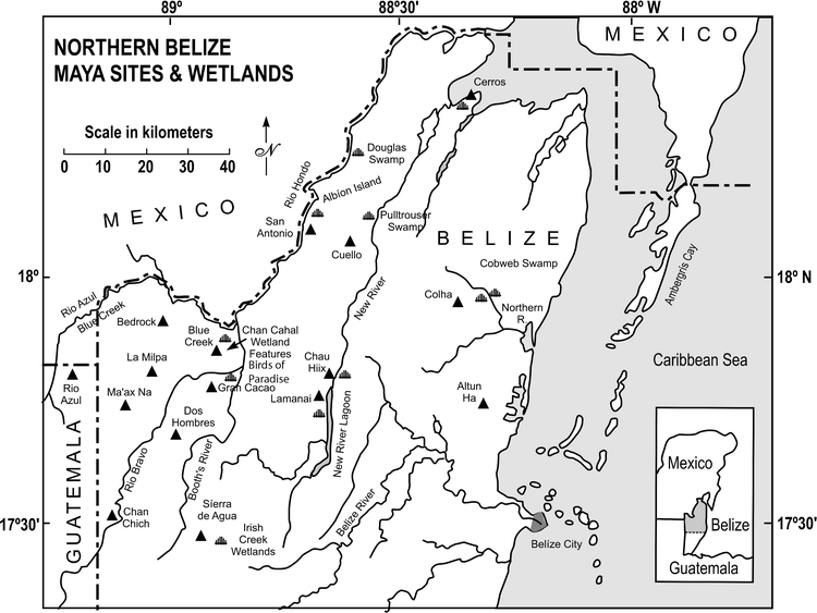
Map of Study Region in Northwestern Belize, Central America (after: Luzzadder-Beach and Beach 2009; Cartography by D. Klemm, Georgetown University Medical Center Illustration Lab).
One area of Maya research that has addressed water chemistry is ancient Maya wetland agriculture, considering the relationship of water quality to sediment sourcing, sea level rise, aggradation (vertical sediment accumulation), possibly drought, and ancient agriculture in the context of ancient wetland fields of Belize's coastal plain (Beach et al. 2006a; Berry and McAnany 2007; Jacob 1995; Jacob and Hallmark 1996; Luzzadder-Beach and Beach 2009; Luzzadder-Beach et al. 2003, 2004; Pohl et al. 1996; Pope et al. 1996; Stein 1990). This line of research has opened a new avenue for understanding and interpreting the nature and origin of landscape change and ancient agriculture in the tropical Maya Lowlands, the latter being this paper's focus.
Background
The basic parameters of water quantity and quality in the Three Rivers Region include: seasonality, high interannual variability with a four month drought period (January–April), hurricanes, changing zones of salt and fresh-water, farming perennial and seasonal wetlands (internally drained swampland bajos), and extremes of soil moisture and soil erosion (Beach 1998; Beach et al. 2006a, 2008; Dunning et al. 2002). Recurrent drought, with obvious water management implications, also had important effects on water quality over several periods, especially the Terminal Classic (Hodell et al. 2007). There has been a steadily growing literature on Maya civilization's strategies for coping with the region's seasonal and long-term fluctuations of water supply (Dunning et al. 2002; Johnston 2004; Lucero and Fash 2006; Scarborough 1991; Scarborough and Gallopin 1991). There is also a long history of research on water control features, such as dams, canals, and diversions, which the ancient Maya likely used for irrigation, drainage, or to protect springs and fields from runoff as well as circumstantial evidence for ancient irrigation (Beach and Dunning 1997; Beach et al. 2002; Matheny 1978). Yet, the agricultural challenge of water quality is one that few archaeologists have considered.
Julie Stein wrote in 1990 that it is essential to study the interaction of source waters (the Rio Hondo, in her study site) and sea level rise, to better understand how ancient agriculture related to the river in the Albion Island region of Belize (1990:323). Stein, as part of a larger study of ancient Maya wetland agriculture (Pohl 1990), sampled water sources in and around Albion Island in 1982 to study the relationships of dissolved and suspended sediment loads of the surface water sources, geology, and the formation of nearby wetlands around Albion Island. Her goals were to explain how one meter of sediment came to bury the agricultural surface and to test a hypothesis of canal construction in response to this aggradation and sea level rise (Stein 1990:324). These data also provided a baseline for regional comparison and insight into the quality of the waters themselves, and their potential for precipitating minerals into the region's soil. One such insight was a “dramatic” amount of dissolved gypsum and carbonates from geologic sources in the Rio Hondo and local groundwater (Stein 1990:326). This insight formed the basic mechanism to explain the aggradation of Preclassic fields by the direct precipitation of carbonates and gypsum from the local water (Stein 1990:329).
A related team (Bloom et al. 1983) conducted a parallel study of the alluvial soil of the Rio Hondo-San Antonio region of Belize, and reported that the river was close to saturation in sulfate and calcium, and that this saturated groundwater could be the source for the dry season's high rates of mineral precipitation. Bloom et al. (1983:419) found that extensive ditching of the wetland fields predated the Classic period of peak population in the Maya Lowlands, and that it was more likely an adaptation to rising sea and correspondingly rising groundwater levels.
Pohl et al. (1996) follow these findings, placing the ditching in the northern Belize coastal plain in the Early Preclassic at 1000 B.C., and abandonment of the ditched wetland fields largely by the Classic period due to permanent flooding and saline water. Pohl et al. (1996) focused on low-lying, perennial wetlands allowing them to estimate a regional sea level curve. Berry and McAnany's (2007) wetland fields investigation at K'axob on Pulltrouser Swamp revealed a more diverse chronology of wetland fields with continued use through the Classic period. Interestingly, none of these research teams specifically addressed the potential effect of water chemistry on domestic consumption, though Pohl et al. (1990:214–215) did briefly address the effects of water quality on crops. Pohl's team's own water and soil chemistry measurements showed high levels of salts, especially sulfate, which helped them to explain why D. Puleston's experimental wetland fields may have produced poor maize and poorer bean yields but better success with the more salt-tolerant cotton; yet at the time they had no estimate of how long the fields had been salty (Leino and Pohl 1990:86; Pohl et al.1990:192, 214–215; both after Puleston 1978).
Thus far, our research from 2000–2008 at Blue Creek has produced a different model, summarized in four parts (see Beach et al. 2008 and submitted, Luzzadder-Beach and Beach 2009). First, the soil surface in this region was 1 to 2 m lower than present from the Archaic through the first half of the Preclassic, forming in well-drained or seasonally drained conditions, and Maya farmers were burning and cropping this landscape with Zea mays L. and a range of other crops since the Archaic. Second, water tables rose creating wetlands starting in the latter half of the Preclassic. Third, the wetlands started to aggrade (accumulate sediments vertically) around 2000 BP by floods, peat accumulation, and gypsum precipitation. Fourth, after or during this time, Maya farmers started to ditch this landscape and reclaim their buried fields. In the Blue Creek-Chan Cahal area, the lowest canal sediments date to the Late and Terminal Classic, and Classic period artifacts dominate the fields and canals. The model we present for the Birds of Paradise wetland fields, just 7 km south of the Blue Creek archaeological site center, is different still, with evidence of rapidly and continually aggrading floodplains from the Late Classic to the present, Maya ditching in the Late and Terminal Classic, and some recent evidence for occupation in the Postclassic (Beach et al. submitted). We selected these sites because of their potential for ancient Maya wetland agriculture and ditched fields (Beach and Luzzadder-Beach 2004) and because they are less disturbed, they will allow better understanding of the potential native variation of species that can exist under the current water chemistry and other environmental conditions. For plant authority we follow the International Code of Botanical Nomenclature (Geuter et al. 2000), the Integrated Taxonomic Information System (ITIS 2007), and The Missouri Botanical Garden “Discovered Bibliography” (Freeland 2007). We focus here on the water quality in the Blue Creek-Chan Cahal and Birds of Paradise wetland agricultural fields, and in the broader Three Rivers Region.
Evaluating Water Quality and Water Use
Several general parameters allow for evaluating water quality for agricultural and domestic water use potential in the modern world. Here we transfer these modern criteria to our ancient Maya study sites to establish both present and past potential water uses and limitations. This work is done in the same spirit as Gómez-Pompa and colleagues' work on the Maya forest today as a window on past use (e.g., Allen et al. 2003; Gómez-Pompa et al. 2003). Since we use several key sources to judge water conditions, our findings about ancient indigenous cultivation and water quality have significant implications for contemporary use and development (Erickson 1998; Gómez-Pompa et al. 1982).
Ayers and Westcot (1994) summarize these water limitations in their FAO report “Water Quality for Agriculture”, and a broad literature from many other sources report similar guidelines (e.g., Bauder et al. 2006; CDWR 1978). The major water quality parameters considered for agriculture include salinity, sodium, pH, alkalinity, minerals (or ions), metals, and microbes (Ayers and Westcot 1994; Bauder et al. 2006). Water for domestic consumption considers the same parameters, but with different thresholds and additional variables such as nitrate for human health considerations (CDWR 1978), discussed below. The parameters we use in this assessment include Total Dissolved Solids (TDS) and Electrical Conductivity (EC); Salinity and Chloride; Nitrate; Sulfate and Calcium [Gypsum (CaSO4·2H2O)].
Many of these parameters are easily measured in the field. For example, Electrical Conductivity (EC, µS) is a useful summary field parameter for rapidly evaluating irrigation waters, since it is a measure of total minerals, and has a predictable mathematical relationship with salinity (Sal, ppt) and with total dissolved solids (TDS, mg/l). EC meters measure EC by passing an electrical current through the water, dissolved minerals conduct this current at a rate proportional to their concentration, and the meter records this relationship. As an example, typical Mesoamerican and Latin American crops such as maize (Zea mays L., Poaceae), beans (Fabaceae) (and other legumes such as alfalfa, Medicago sativa L., primarily a North American animal feed crop), potatoes (Solanum tuberosum L), and onions (Allium cepa L.) are less tolerant of salinity measured as EC than are cotton (Gossypium L.) and grain crops such as wheat (Triticum L.) and especially barley (Hordeum vulgare L). The higher the EC, the higher the reduction in crop yields (Bauder et al. 2006), to the point where few traditional agricultural crops grow at EC levels of 3000 µS or greater (CDWR 1978).
Most experts recommend evaluating salinity as the Sodium Adsorption Ratio (SAR) and Adjusted SAR (ASAR), which consider the mathematical and ionic relationship between Na+, Ca+2 and Mg+2 (Bauder et al. 2006; CDWR 1978) and the combined effect of these ions on how plants may draw water from soil particles. Stone fruit orchard crops such as plums or apricots (Prunus L.) and field crops such as tomato (Solanum lycopersicum L.) suffer earlier foliar damage (Bauder et al. 2006) from the ions of sodium (Na+) and/ or chloride (Cl−) than do crops of peppers (Capsicum L.), potatoes (Solanum tuberosum L.), and maize, although these trail the non Mesoamerican crops of alfalfa, barley, and sorghum (Sorghum Moench) in tolerance. Interestingly, one of the most sodium or chloride tolerant plants, and one that was an early part of the Mesoamerican diet (Pope et al. 2001), is the sunflower (Helianthus annuus L) (Bauder et al. 2006). Tree and vine crops are more susceptible to chloride toxicity than are annual crops (Grattan and Oster 1992), since these plants persist from year to year and must adjust to water stresses, including chemical stresses, and yearly variations in supply. Palms seem far superior in terms of crop yield and tolerance to dissolved salts as EC than do citrus (Citrus L.) or stone fruit orchards and vine berries (Grattan and Oster 1992). Avocado (Persea Americana P. Mill) is less tolerant of salinity (Grattan and Oster 1992), sodium, and chloride (Ayers and Westcot 1994) than are citrus and other crops, with a maximum recommended salinity of about 140 mg/l (0.14 ppt or 3.93 meq/l; Grattan and Oster 1992) and chloride of 4.0–6.0 meq/l (141.8–212.7 mg/l; Ayers and Westcot 1994).
Water supply is also a major consideration, and Balerdi et al. (2003) present flood and drought tolerance information for tropical crops, based on research at the University of Florida's Institute for Food and Agricultural Sciences. Both too much and too little water can stress plants and interfere with their uptake of water and nutrients and can cause different concentrations of ions in the root zone. Balerdi et al. (2003) note that the tree crops of avocado and papaya (Carica papaya L.) are not tolerant of either flood or drought, that bananas (Musa L.) are moderately tolerant of both; that mamey sapote (Pouteria sapota (Jacq.) H.E. Moore & Stearn) is not flood tolerant but is moderately tolerant of drought, and that guava (Psidium L.), coconut (Cocos nucifera L.), sapodilla (Manilkara zapota (L.) van Royen), and citrus are all moderately to fully tolerant of both flood and drought conditions (Balerdi et al. 2003).
Since our study regions have been under the influence of rising sea levels and rising ground water tables (Gischler and Hudson 2004; Pohl et al. 1996; Toscano and Macintyre 2004), tolerance to salinity is another important consideration in evaluating the probable changing conditions of water quality over time. The effect and possible implications of sea level rise on various crops is three-fold. First, sea level rise drives a mineral saturated groundwater table upward into the root zone, and thus plants or crops that may have thrived on rain-saturated soil can be exposed to potentially harmful, mineral-laden groundwater. Second, high water tables can water-log plant roots, causing problems for species less tolerant to flooding. Third, a less direct effect is that soil quality is altered when mineral laden groundwaters precipitate out minerals into higher strata of the soil column, adding salts and other minerals to otherwise fertile soil. This accumulation, in turn, literally raises the elevation of the soil surface and buries the original planting surface by aggradation (a more detailed discussion of this geomorphic process is presented in Luzzadder-Beach and Beach 2009). To connect these water quality, water supply, and plant growth basics, we use a new case study from our multidisciplinary and long-term research in the Three Rivers Region of northwestern Belize.
Three Rivers Study Region
The Three Rivers Study Region watersheds span an area of 1,625.63 km2 at the nexus of three countries, Belize, Guatemala, and Mexico. Our soil and archaeology fieldwork focuses on the northwestern Belize (downriver) portions of the watersheds. The rivers include Rio Azul/Blue Creek, which follows the Guatemala-Mexico and Belize-Mexico international borders respectively, and the Rio Bravo, which arises in eastern Guatemala and converges in Belize with the third river, Booth's River. All three rivers then converge in far northwestern Belize to form the Rio Hondo, tracing the border between Belize and Mexico, and debouching 70 km beyond into Chetumal Bay (Figure 1). Our water resources and environmental investigations occurred within three adjacent natural resources conservation, agricultural, and archaeological regions: the Programme for Belize Archeological Project in the Programme for Belize Rio Bravo Conservation Area (PFB-RBCA) surrounding the La Milpa Maya site, the Chan Chich-Gallon Jug Experimental Farm abutting the PFB-RBCA to the south, and the Maya Research Program-Blue Creek Archaeological Project region, located north of and adjacent to the PFB-RBCA.
The Three Rivers and associated groundwater systems and lakes are all a part of the south central Yucatán Platform, a carbonate and karst system of mainly Cretaceous through Tertiary limestones and dolomites (Luzzadder-Beach and Beach 2009). The Cretaceous limestone is one of the geologic sources of sulfates in the region's groundwater (Luzzadder-Beach and Beach 2009; Pope et al. 1999). Several southwest to northeast trending faults fracture the Yucatán Platform, forming a series of escarpments through Belize and adjacent Mexico and Guatemala. Our study focuses on the Rio Bravo escarpment area, through which the Rio Bravo and Blue Creek flow. This escarpment separates the uplands from the lowlands in the region. In this study, “uplands” and “lowlands” are local topographic terms, distinguished from the broad regional term “Maya Lowlands.” Uplands refers to locations on the uplifted block of the escarpment, and the lowlands are a location below the escarpment/fault zone, in Belize's northern coastal plain. Highly mineralized springs emerge from an aquifer below the escarpment in the fault zone and feed lakes, wetlands, and streams at the base of the escarpment; intermittent streams and bajo depressions occupy the uplifted blocks on the backslopes of the escarpment (Dunning et al. 2002, Beach et al. 2008). The Three Rivers Region and the Rio Bravo Conservation Area straddle both the uplands and lowlands, and several Maya archaeological sites fall within this region. Of these sites, La Milpa (Hammond et al. 1998; Scarborough et al. 1995), Blue Creek (Guderjan 2004; Lohse and Sagebiel 2005), and Gran Cacao (nearest to the Birds of Paradise site) occur in the uplands. Chan Cahal and Birds of Paradise comprise the sites in the lowland portion of this study area (Figure 1). The Birds of Paradise site is in the Programme for Belize Rio Bravo Conservation Area, and is our least disturbed site for paleoecological study in the perennial wetlands.
At 17.5 degrees north latitude, the study area has a seasonal tropical climate, influenced by the Inter Tropical Convergence Zone (ITCZ) and the southern edge of the Subtropical High Pressure, or the Bermuda High. These large systems create distinctly wet and dry seasons, and situate Belize and much of the Yucatán Peninsula directly in the path of hurricanes and other seasonal tropical disturbances. Annual precipitation totals about 1500 mm, but with interannual variability (Dunning et al. 2002; Luzzadder-Beach and Beach 2009).
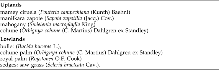
This region's broadleaf, semi-deciduous tropical vegetation is well adapted to the extremes of this wet and dry climate region. Within our region, the plant communities vary from tropical forests in the uplands to herbaceous and forested wetlands in the lowlands. Brokaw and Mallory (1993) inventoried the vegetation in and around the Rio Bravo Conservation Area. Table 1 lists some typical plant species of the uplands and lowlands. Brokaw and Mallory (1993) included no agricultural species since this is a conservation area.
Examples of Predominant Natural Vegetation of the Rio Bravo Conservation Area (after Brokaw and Mallory 1993).
One of the more significant hydrologic changes over time has been the net rise of the groundwater table through the Holocene in the coastal plain, due to a sea level rise of about 1 m to present levels over the last 3000 years (Gischler and Hudson 2004; Pohl et al. 1996; Toscano and Macintyre 2004). The influence of this change reaches 70 km or more westward from the Belize coastline (0 msl) to the base of the Rio Bravo Escarpment (8–10 msl), where the water table currently resides near the modern surface in our lowlands study area (Luzzadder-Beach and Beach 2009; Wright et al. 1959). The implications for agriculture are both beneficial in terms of a water source in the dry season and micrometeorological moderation (e.g. humidity and temperature effects), and potentially harmful in terms of a highly mineralized water table in the root zone, which can add mineral salts to the soil as water evaporates, and water-log the roots of sensitive plants.
Methods
For more than a decade we have monitored the water quality of the Three Rivers Region of northwestern Belize, mainly during our late spring field seasons. We have collected more than 100 water samples and associated field measurements from a wide network, and have brought these samples back to the United States for analysis in the controlled environment of our George Mason University Water Quality Lab (Fairfax, Virginia; see Table 4 for results). We have undertaken this research to establish a baseline of information about current conditions and spatial variations in the water supply. Our goals have also been to establish sources of these waters and to provide clues about their suitability for domestic and agricultural use in the context of the ancient Maya who once inhabited the region's sites including La Milpa, Dos Hombres, Chan Chich, Blue Creek, and Gran Cacao, among others (Luzzadder-Beach and Beach 2009; Figure 1). In related research, we have established that there is a distinction between characteristics of the upland and lowland waters, separated by the Rio Bravo escarpment (Luzzadder-Beach and Beach 2009). This paper tests the potential effects of that distinction upon agricultural and domestic uses.
Based on our coverage of water quality testing and methods (see Beach et al. 2008 and Luzzadder-Beach and Beach 2009 for methods and individual sample level data), here we focus on seven parameters and their effects on domestic and agricultural use potentials, and reflect on the established standards discussed earlier: Total Dissolved Solids (TDS) and Electrical Conductivity (EC); Salinity and Chloride; Nitrate; and Sulfate and Calcium, or Gypsum (CaSO4·2H2O) (Table 4). We compare these parameters with the archaeological, geomorphological, soil, and ecological findings recovered from more than thirty wetland field excavations conducted between 2000 and 2008 (Beach et al. 2008; Luzzadder Beach and Beach 2009).
Results
Botanical Results and Interpretations
During our 2006 field season, paleoethnobotanist David Goldstein (2006) conducted an inventory of voucher specimens (Table 2) in the boundaries of the Programme for Belize Rio Bravo Conservation Area, including our lowland Birds of Paradise site. It is named for the False Bird of Paradise plant (Heliconia latispatha Benth.) that is a prominent species at the site today. Although some species are modern invasives or garden escapees (e.g., Mangifera L.: mango), many other potentially Precolumbian economic plants were identified in the survey (Table 2). This sample also provides clues about the potential composition that the forest may have had before modern settlement, what kinds of economic species may have been available to earlier inhabitants of the region, and it supplements our soil and geomorphological evidence collected from our archaeological excavations (reported in Luzzadder-Beach and Beach 2009). It also provides evidence that, despite the highly mineralized water of the lowlands, there is potential for maize agriculture and some arboriculture.
Fields of Paradise 2006 Collected Voucher Specimen Inventory (Goldstein 2006).

Carbon isotopic ratios from soil organic matter provide another line of evidence. Both at Chan Cahal and the Birds of Paradise fields, soil changes from a C3 signature of tropical forest in the upper horizons (Postclassic, −28‰) to a mixed C3 signature in Classic through Preclassic period sediments (−23‰), but at Chan Cahal changes back to tropical forest C3 signature (−28‰) below. The rapid alluviation at the Birds of Paradise site has not allowed us to excavate down to the Preclassic levels yet. This reflects mixed C4 and C3 vegetation in wetland fields in the Classic and in the Preclassic at Chan Cahal (Beach et al. 2008). These patterns parallel the other lines of macrobotanical data, indicating a mixture of C4 tropical grasses like Zea mays L. and tropical broadleaf or forest species (Beach et al. 2008).
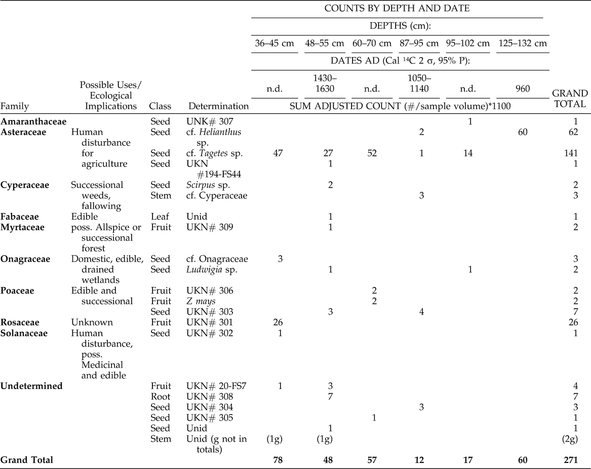
We also conducted flotation analysis to collect macrobotanicals from our archaeological field site, and reported on species presence by depth (Table 3). We compare this with AMS dates we obtained within these strata (Beach et al. 2008; Luzzadder-Beach and Beach 2009) in Table 3 as well. If the fields of Birds of Paradise were used for agricultural activity for a long period of time, then the macrobotanical samples may provide evidence for agriculture and farming practices. These findings support the hypothesis that there was a diverse set of possible economic plants used in the Birds of Paradise lowlands-wetlands field complex by the ancient Maya, and therefore ancient Maya farmers were able to use these species in spite of local water quality. The archaeobotanical research will be expanded in future field seasons.
Determination of Recovered Plant Materials by Column Level, Date, and Adjusted Count, Birds of Paradise Field Site, Trench BP3A (Goldstein 2007).
Water Quality Results and Interpretations
The mean value for TDS in our study region uplands was 262 mg/l, and for the lowlands it was 1144 mg/l (Table 4). According to water quality guidelines (Ayers and Westcot 1994; CDWR 1978) the values in the uplands pose no limitations as irrigation water while the values in the lowlands exhibit slight to moderate limitations due to salinity as TDS. Electrical Conductivity (EC, µS) also show a pattern of better quality in the uplands (548 µS on average; this is below the standards of 900 µS for drinking water and 750 µS for irrigation water (CDWR 1978) and less suitable quality in the lowlands (2247 µS on average) far above the maximum standards for both drinking and irrigation water (Ayers and Westcot 1994; CDWR 1978).
Summarized Water Quality Analyses 1997–2007, Northwestern Belize.
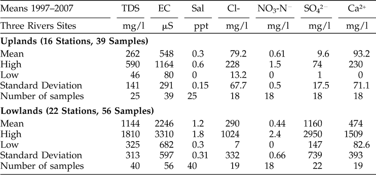
The mean chloride level in our upland water sources (79.2 mg/l, Table 4) is less suitable for agriculture, but does not exceed standard limits for applications to crops (limit = 250 mg/l, USEPA 1995) and is lower than that of the lowlands. High chloride in most lowland and wetland water sources (mean = 289.7 mg/l) does pose limitations on crop production, especially on young crops (CDWR 1978; Luzzadder-Beach 2000). Indeed, today these areas are being actively drained by modern farmers encountering similar difficulties cultivating maize using the highly mineralized groundwater for irrigation. The current draining of fields for agricultural uses favors the former Maya fields for cattle pasture and tolerant crops such as rice rather than for intensive and more sensitive crops such as maize.
Nitrate is an important indicator for the suitability of domestic water for human consumption (Luzzadder-Beach 2000). Nitrate concentrations equal to or greater than 1.0 mg/l as NO3 were found present in two Rio Bravo Stations, the Programme for Belize Camp's modern supply well (uplands), and one wetland spring in the Chan Cahal northern wetlands, in a cattle pasture (lowlands). The mean nitrate value for the uplands was 0.61 mg/l, and the mean value for the lowlands was 0.44 mg/l (Table 4). These values are not harmful for drinking water compared with the USEPA health standard of 45 mg/l as NO3 or 10 mg/l as N (USEPA 1976). Nitrate presence is an indicator of some pollution nonetheless, and these findings may be explained by modern non-point sources upstream, perhaps by nearby farming and cattle ranching operations and modern campgrounds and field stations. Most other water sources showed little or no background nitrates, suggesting that potential nitrate pollution during ancient Maya times may have likely been only anthropogenic, from sewage and organic refuse. Of course, because of the ephemeral nature of any water quality measurement, as opposed to soil chemical signatures that may remain for centuries (e.g., phosphates are used as indicators of human activities; Eidt 1977), it would be unlikely to produce direct evidence of anthropogenic nitrate pollution dated to the time of the ancient Maya. The soil from some wetland fields and canals does indeed have elevated phosphorus in ancient strata, but this could be from either phosphorus polluted water or deliberate additions to enrich the soil.
When the upland waters are compared with the lowland waters, sulfate (SO4−2) occurred in sharply differing concentrations. The upland sources averaged only 9.6 mg/l SO4−2; lowland sources averaged 1159.7 mg/l (Table 4). The latter measure exceeds the human health standard of 250 mg/l (CDWR 1978); therefore the waters of the uplands are far more suitable for human consumption than the lowland waters. Sulfate combines with calcium (Ca+2, Table 4) and water to form gypsum (CaSO4·2H2O). Lowland soil had high amounts of gypsum, and some water samples were saturated or nearly saturated by SO4−2 and Ca+2. Mean calcium levels in the uplands were 93.2 mg/l, and in the lowlands were 474.4 mg/l. The high gypsum in the soil is aggraded by precipitation from the gypsum-saturated groundwater, driven upward by sea level rise (Luzzadder-Beach and Beach 2009).
One other line of evidence on water quality is the evidence for the world's largest water pollutant – eroded soil. Several studies have now linked the Late Preclassic through Classic period to high rates of soil erosion in and near the study region (Anselmetti et al. 2007; Beach et al. 2006a, 2008), and since soil erosion also removes nutrients like phosphorous and nitrogen, runoff carrying eroded soil is rich in these nutrients and these often lead to many nutrient loading and biological pollution problems in waters that receive eroded soil. For example, the “Maya Clays” or eroded sediments in many Maya regional lake cores often are significantly elevated in phosphorous (Dunning and Beach 2008). This sediment and nutrient pollution would have affected upland and lowland waters alike because both received the eroded sediments.
Our water quality and soil investigations have demonstrated no water quality limits on upland terraces in the region's relatively fertile tropical Mollisol soil, though erosion from these may have contributed to downslope pollution (Beach et al. 2006b; Luzzadder-Beach and Beach 2009). Many pollen samples from these upland sites include Zea mays L. near ancient Preclassic fields and, interestingly, in the thick gypsum sediments associated with the Classic fields above them (Beach et al. submitted). A conversation on 31 May 2005 with local landowner and rancher, Ed Reimer, confirms modern lowland water use difficulties for growing maize (Zea mays L.). Mr. Reimer had recently started a center pivot irrigation project in the lowlands below the Rio Bravo Escarpment. The local water was used to irrigate maize. The irrigated maize was dead or stunted while the rain-fed maize, out of reach of the sprinkler system yet in the same soil type, was productive.
These water quality data indicate that current lowland water limits crops, but this has not always been the case. Our previous geomorphic study demonstrates a chronology and mechanism of water quality change in the form of the soil chemistry of dated strata. Soil layers from before c. 2200 BP (Maya Late Preclassic) have significantly lower quantities of gypsum compared with the younger, overlying strata from the later Late Preclassic and Classic periods. Indeed, these buried earlier soil strata also have substantial evidence of Maya agriculture in non-wetland conditions. Hence, the overlying Maya wetland fields and canals at Blue Creek, which date between the Late Preclassic and Terminal Classic, must also have been adaptations to water inundation conditions. This prehistoric effort was to improve water quality for crops to drain low quality water away and leach excess gypsum in the otherwise fertile organic soil (Luzzadder-Beach and Beach 2009).
Conclusion
Water quality has been neglected in Maya archaeology, despite its importance as a chief resource for humans. It has a strong influence on such things as seed germination and growth of agricultural crops, both annuals and perennials. Modern water quality studies give us important clues about possible past water conditions. Added to multiple lines of evidence of environmental change including climate, hydrology, soil, lake cores, population, land use, and geology, water quality data brings these dimensions into focus. This case study across an ecotone of the karst environment of the Maya Lowlands offers strong evidence that water quality varies greatly, more than expected even within one watershed (such as the Rio Bravo). As demonstrated, water quality can vary abruptly over both time and space, even over short distances. This has strong implications for the history of crops, consumption, and natural ecosystems. The upland portion of the Three Rivers Region of Belize has had far superior water quality for both drinking and agriculture than the nearby lowlands. The main limitation on the uplands has been sufficient water for plant growth through the dry season, and the only limit for domestic water consumption has been pollution. In the uplands, pollution from soil erosion dated to Late Preclassic through Classic periods and would have also carried a range of chemical and biological pollutants as well. Our geochemical study revealed that the lowland and wetland portions of the Three Rivers Region, with abundant water resources, have highly mineralized ground waters from sources different from the upland waters. Today, the water is proving to be injurious to modern attempts to grow maize, and modern farmers are vigorously attempting to drain and reclaim the very same wetlands that ancient Maya farmers sought to improve as sea level pushed up the water table, lengthening the duration of highly mineralized water in the field areas (Luzzadder-Beach and Beach 2009). With these limitations, many potential economic species of trees and other plants can survive here under current water quality conditions, offering clues about alternative crops for the ancient farmers in the region. Indeed, pollen evidence indicates that growing Zea mays L. and many fruit trees from the Preclassic through Classic periods was possible with water management (Beach et al. submitted). Our continuing field work in the newly discovered, relatively undisturbed Late to Postclassic era wetland field sites, such as the Birds of Paradise, helps to shed light on ancient Maya agriculture and water management under conditions of rising water table zone below the Rio Bravo Escarpment in Belize.
Footnotes
Acknowledgments
Partial funding was provided by National Geographic Society CRE Grants 7506-03 and 7861-05; additional funding was provided by George Mason University's Center for Global Studies and College of Science, and Georgetown University's School of Foreign Service. We wish to thank our colleagues and students who have assisted us over the years, including Drs. N. Dunning, J. Jones, V. Scarborough, K. Pope, S. Bozarth, D. Goldstein, S. Armbruster, G. Perry, J. Buchino, L. Kozakowski, K. Sagebiel, M. Morgan, L. Sullivan, K. Cox Esq., and many others. We are grateful to have worked under the auspices and support of the Maya Research Program, Blue Creek Belize (MRP), with Directors Drs. Tom Guderjan and Jon Lohse; and the Programme for Belize Archaeology Program (PfBAP), with Director Dr. Fred Valdez. We also thank the Institute of Archaeology, Belize, and Blue Creek and San Felipe for welcoming us into their communities and for their assistance. We also wish to thank the editors and the anonymous reviewers for their insightful and helpful revision comments.