
Abstract
Caste-based Hindu coastal fishers of Bangladesh have developed their Traditional Ecological Knowledge (TEK), environment and resource friendly practices, and worldviews through years of social learning, and interaction with their immediate ecosystem. This article is based on 21-month long participatory field research with the fishers of Thakurtala fishing village, Moheskhali Island, Cox'sbazar district, located along the Bay of Bengal. Eight important categories of fishers’ TEK systems are examined: water color, wind direction and current, lunar periodicity, sediment and topography, celestial navigation, birds and animals, mangroves, and fishing sites. Fishers make their decisions about fishing at a certain site using practical heuristic rules. The sequence of learning and transmission of TEK at different age strata is examined. Policy makers would benefit from TEK of the experienced coastal fishers.
Introduction
Traditional Ecological Knowledge (TEK) is a fluid mix of empirical/practical knowledge, and institutional knowledge, constructed through years of framed expert insight about the ecosystem and the aquatic resources therein, and hence, it is socio-culturally specific, constructed, and bound. TEK, considered as “a cumulative body of knowledge, practice and beliefs” (Berkes 2008), is a form of human capital and capability of fishers that reflects the stock of individually possessed knowledge, experience, competence, and skills that help fishers optimize catch from the sea. Artisanal fishery is dependent on the qualitative knowledge system of the fishers (Grant and Berkes 2007; Johannes 1989; Raychaudhury 1980) for its overall operation and management. Artisanal fishing is not only a source of livelihood, but also an art of living for fishers that is characterized by a long tradition of adaptation to the dynamics of the social and natural environment, cultural heritage, and a rich body of TEK.
Fishers’ TEK is a form of “expert system” that is comprised of certain heuristic rules about how to accumulate and filter learnings, and how to apply the lessons for solving complex problems related to harvest and management practices (Grant and Berkes 2007; Mackinson 2001). It is crucial in their decision making process in the sea. Grant and Berkes (2007) consider such a cumulative pool of knowledge an expert system, which is almost solely based on observation-based experiential learning, a useful lens to understand how fishers use certain heuristic rules to maximize their catch.
The dynamic ecology of the Bay of Bengal in the Indian Ocean and the rich biodiversity therein, provide a rich setting for examining fishers’ TEK. A clear understanding of the richness of TEK of Bengali artisanal fishers would go a long way in maintaining biological productivity of the ecosystem and making the aquatic resources available for the livelihood of fishers and the overall economic well-being of the nation. This article explores the “expert system” of the hereditary coastal fishers of Bangladesh. In particular, it examines how TEK is incorporated into their decision-making process when fishing in the sea. I also summarize the perspectives of the artisanal fishery in which traditional fishers operate and survive, and the process of inter-generational knowledge transfer in the fishing communities.
Methods and Study Site
Over a period of 21 months in 2005, 2006, 2009, and 2010, I learned TEK from the fishers of Thakurtala (literally, an area beneath the footprint of Adinath temple, one of the 52 most sacred places for the Hindu pilgrims), a coastal fishing village located in the Moheskhali Island of the Cox'sbazar district along the Bay of Bengal (Figures 1 and 2a). Experienced fishers of six coastal fishing villages (Gorakghata, Pourashava, Paharchanda, Maijghona, Ali Akbar Deil, and Boroghope villages of Cox'sbazar district) with similar religious and socio-cultural backgrounds were also consulted. I also interviewed five experienced Muslim fishers of Ahmediakata, a fishing village located on the north-west side of the major study village, Thakurtala, to get their views on certain ecological parameters.
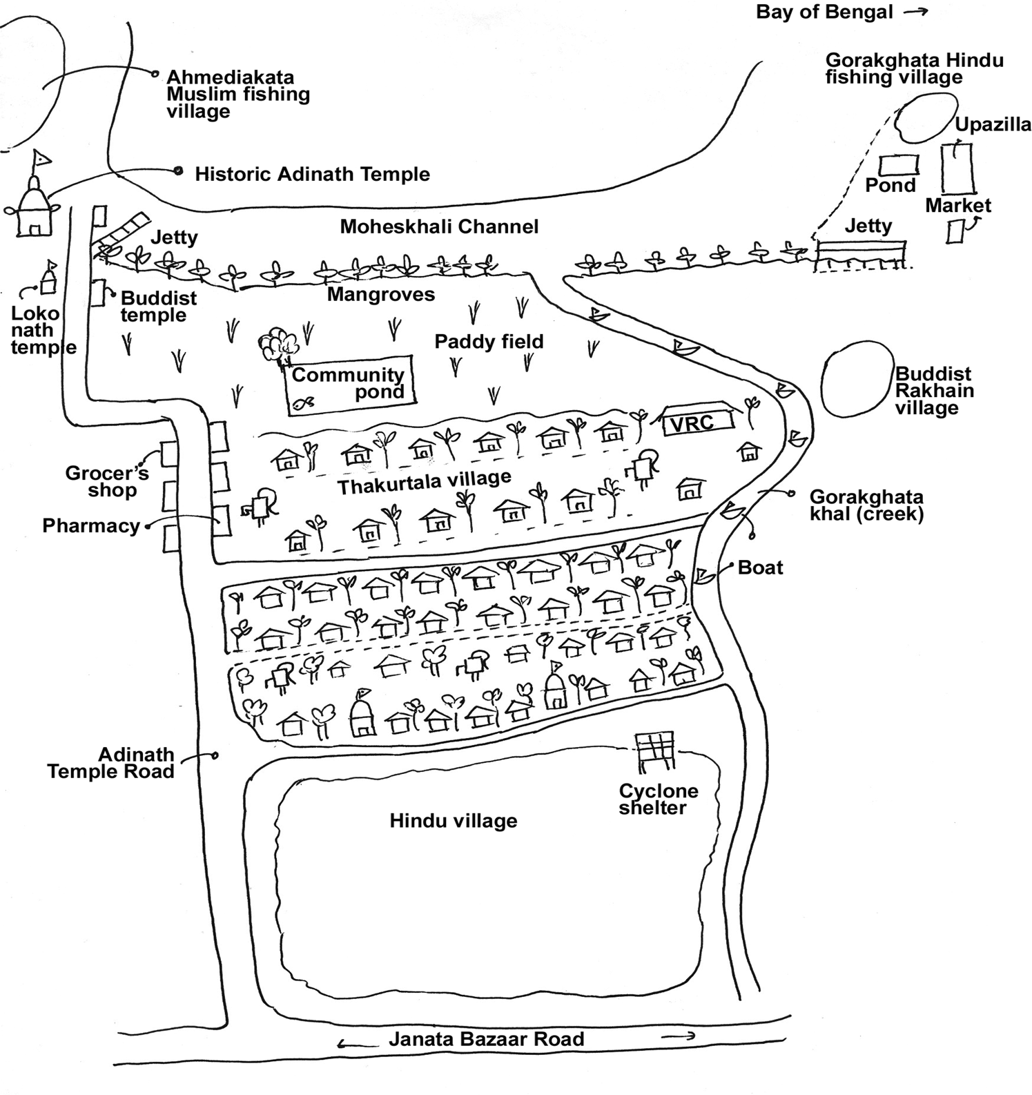
Diagram of Thakurtala village, redrawn from ‘resource mapping exercise’ carried out by fishers.
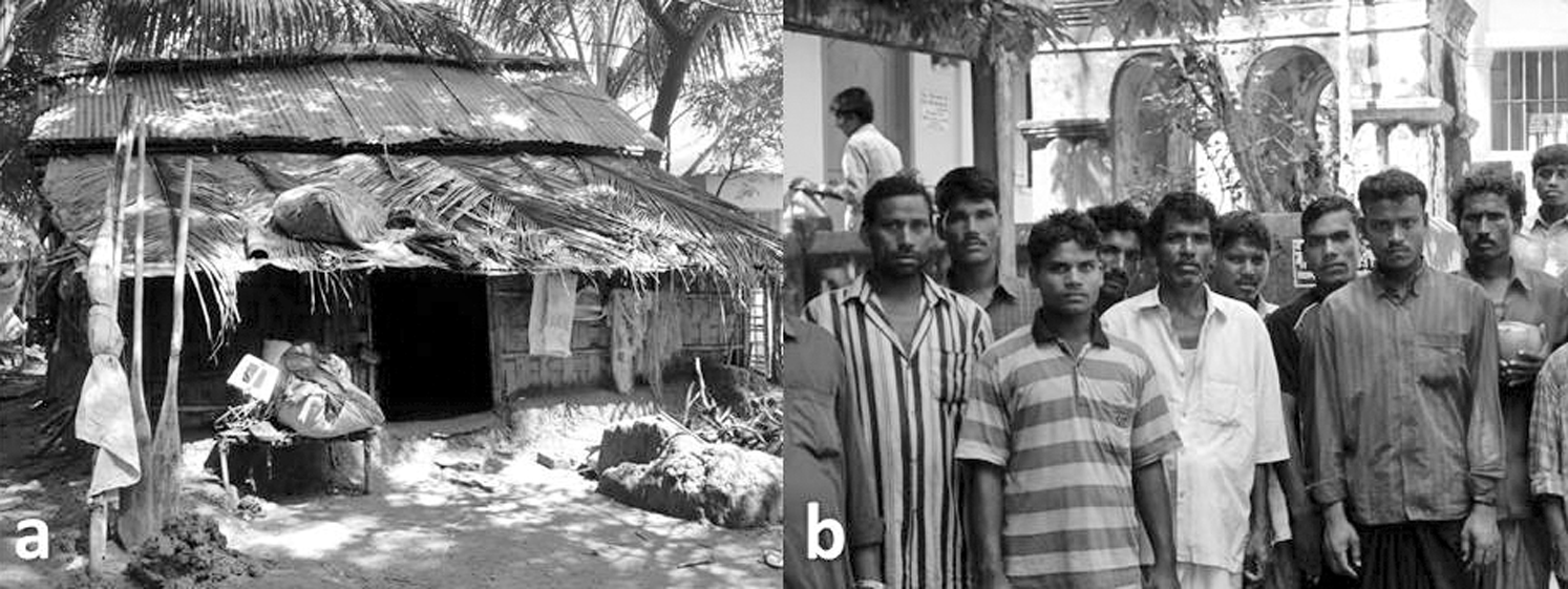
a. House of a fisherman in Thakurtala village; b. sea-faring Hindu hereditary fishers gather for prayer at Adinath Temple, Moheskhali Island, prior to their voyage.
These fishers fish in the coastal and marine water of the Bay of Bengal. The Bay of Bengal is one of the 64 large marine ecosystems of the world, and is geographically shared by eight countries of Southeast Asia. The Bay is very dynamic and widely known as the breeding zone of some of the strongest and deadliest tropical hurricanes in recent history. A combination of strong monsoonal winds, and topographically, a shelving and narrowing bay, causes storm surges to rise very high and drive far inland, causing massive destruction to the lives and assets of the coastal people. This can be devastating if the landfall coincides with the high tide periods in its semi-diurnal tidal pattern.
The inhabitants of Thakurtala village are hereditary Hindu fishers belonging to Jaladas caste (‘slaves of the water’) (Figure 2b). The village has a population of 650 (300 males, 350 females, and 78 households). The outside edge of the village is surrounded by a narrow strip of mangrove forest with a mix of Avicennia spp., Sonneratia spp., and Rhizophora spp. During the peak hours of new moon and full moon phases of the semi-diurnal tide, the low-lying northwest area of the village gets inundated.
I used a qualitative participatory approach (Chambers 1994) for examining fishers in their own social settings. I was interested in understanding fishers’ relationships to other biotic and abiotic things using their lens of socio-cultural constructions. A baseline questionnaire was administered to all 78 households to get comprehensive information on household composition, living condition, assets, food security, employment pattern, income, expenditure, crisis, coping mechanism, and the status of women. Subsequently, 45 key informants were interviewed and 23 Focus Group Discussions (FGD) were organized. Collectively, these data represent 900 years of fishers’ experience in the Bay of Bengal.
The 23 key informants interviewed were selected based on four criteria. First, they had to have at least 10 years of fishing experience. Second, they had to have a reputation in the community for “wisdom” in oceanography, ethnobiology, and folk taxonomy, along with ability in fishing operations and diving, skill in steering, and standing in ritual performance. Third, the fishers had to depend on fishing for their livelihood, and finally, they had to be willing to share their knowledge.
Accompanying fishers on boat trips was the most useful and effective way to learn about fishers’ TEK. Duration of such trips varied from one day to two weeks depending on the type of gear, engine capacity, level of harvest, and carrying capacity of the craft (note: those fishers who have no engine usually fish in the near-shore areas and return on the same day). I joined in 28 trips with the sea-bound fishers for this research. Fishers are more generous and participatory in their responses “on boat” than they are “on land,” and during the evening and early in the night. Informal chat (Aadda) in the local tea stalls, where fishers talk spontaneously while they had hot tea and cookies, was also useful. A group of five to seven fishers was the most effective for FGD.
The information provided in this article has been validated in three “mini-workshops” attended by the most knowledgeable and experienced fishers of the south-east coastal belt. Only attributes prioritized as “most significant” by the experienced key informants are presented here.
The Fishers and their Fishery
The Fishing Community
Thakurtala fishing village is composed of patrilineal and patrilocal households with distinct lineage groups forming clusters; almost all of the men and more than half of the women were born in the village. Marriage is a socio-religious and economic contract settled through a series of ceremonies; it is virilocal. The vast majority of the fishers (N = 78 households, 95%) live in tiny houses built with polyethylene, straw, and coconut leaves.
Fishers in this village belong to the Jaladas caste. Jaladas fishers have low social status, which is enjoined and reinforced by the ideological sanction of ‘acquired congenital pollution’ and caste-strata dictated in Hinduism. The village head (Sarder) steers socio-religious, cultural, ritual, political, and moral functions in the community. Sardery is a male-exclusive, traditional social institution of caste-based fishers.
Traditional coastal fishers are highly prone to natural calamities and accidents at sea. Family members (children, women, and old people) remain uncared for at least six months per year while the men in the household go seafishing as paid laborers. During that time, women take on almost all of the typical male roles (e.g., negotiating with moneylenders) in a temporary matrifocal social construction (Deb et al. 2015). Broadly speaking, although the marine fishing sector cultivates masculinity, these Hindu caste-based fisherwomen go beyond the stereotypical place-based binary performance (sea for men, land-based activities for women).
Poverty is pervasive in fishing communities. Poor parents tend to engage children in income-earning activities to supplement family income. The daily family income of around half of the 78 households is as low as US$ .70-$.90 during the lean fishing periods of the monsoon season. This translates to an allocation of about 10-15 cents per person per day. If we consider three meals per day (when breakfast is replaced by a light meal) as culturally appropriate for working class people in rural Bengal, then the majority of the fishers (N = 650, 80%) are victims of food insecurity, irrespective of seasons. Situations of food insecurity and prolonged hunger worsen after natural calamities.
The Artisanal Fishery
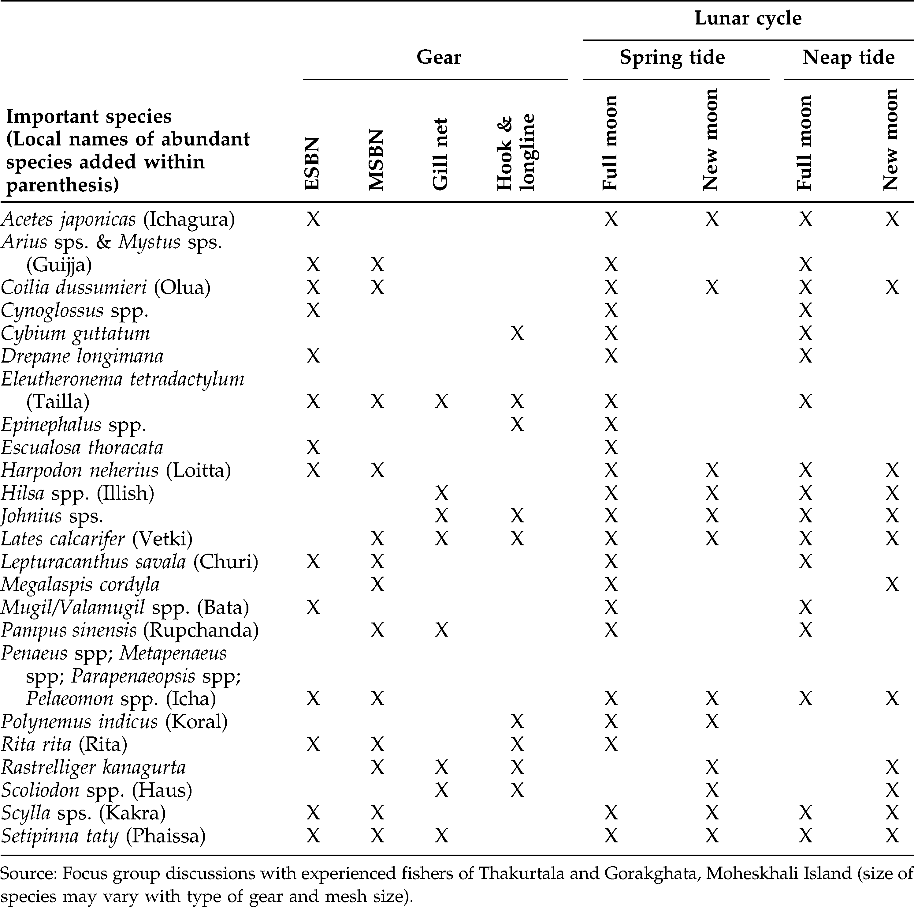
Artisanal fishery in Bangladesh is open access and mostly unregulated. It is characterized by heterogeneous attributes of capital involvement, technologies, labor mobility, dispersed fishing areas, seasonality, various degrees of livelihood dependence, rituals, and social and economic reciprocity. Artisanal fishery has witnessed rapid mechanization in the last three decades that continues to threaten biodiversity, sustainability, and resource governance. More than 100 species of commercially available fish and shrimp are targeted by fishers (Figures 3a and 3b; also see Table 3 for a list of important species with local names). The marine fisheries sector contributes around 20% of the total fish production in the country (around 2.5 million metric tons), of which more than 90% comes from artisanal fishing, with approximately 500,000 people directly involved in it. The exclusive economic zone of the country covers an area of 164,000 km2 with a shelf area of around 66,440 km2, of which coastal shallow water with less than 10 m depth covers around 24,000 km2. Artisanal fishing is mostly restricted to shallow areas of the sea.
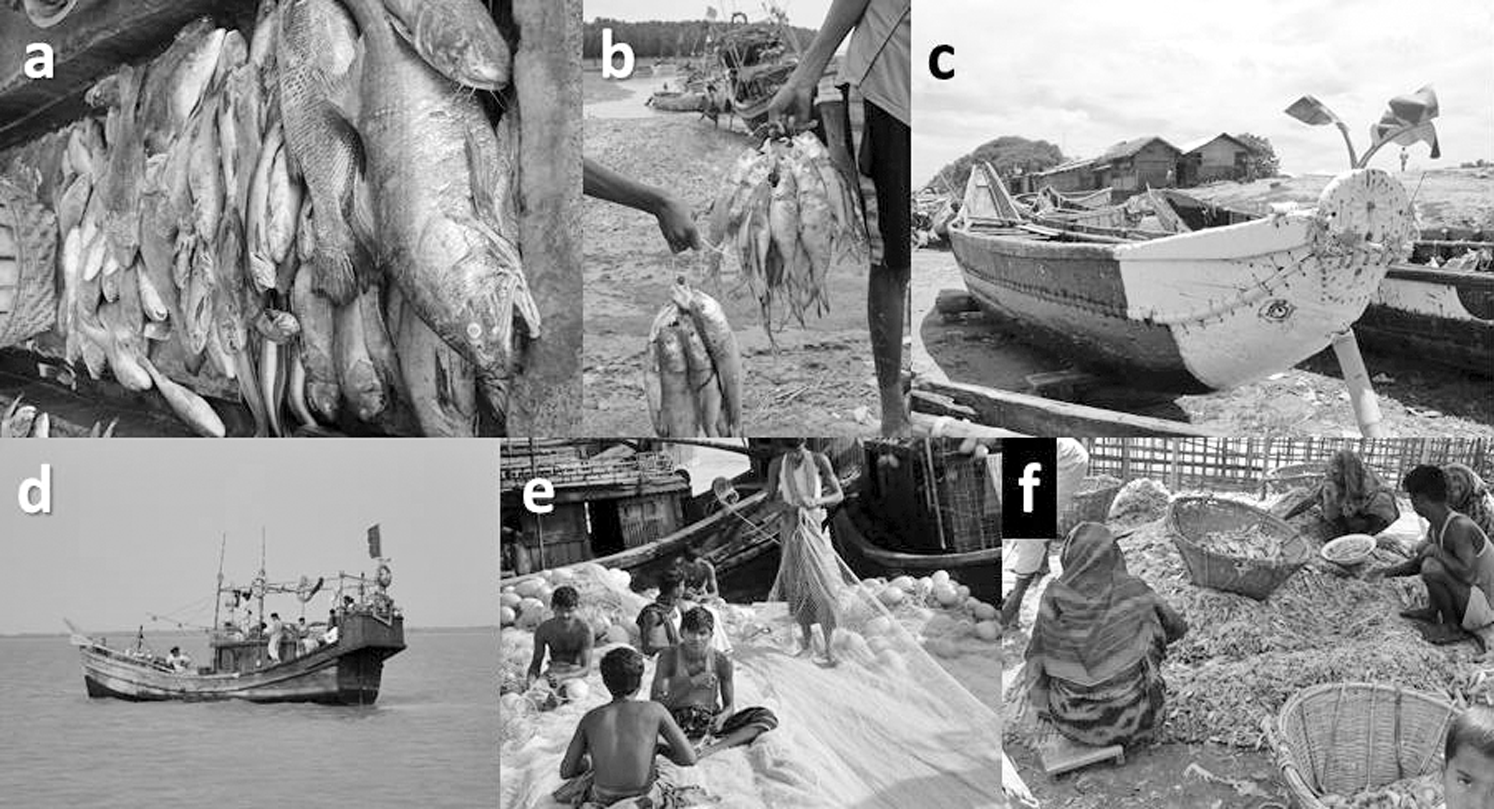
a. Marine fish caught in a gill net; b. majestic Hilsa fish, c. a traditional boat of Hindu castebased fisher after sanctification (note: eye of Goddess Ganga painted in the forehead), d. a sea-bound craft with no life-saving equipment, e. repairing of Hilsa gill net after fishing trips; and f. fisherwomen engaged in post-harvest activities.
Fishing operations vary from diurnal to fortnightly cycles. Usually, set bag nets are operated in shallow areas, and the harvest is gathered following the semi-diurnal tidal cycles. In the study village, only 3.8% of the households (N = 78) have sea-going mechanized fishing boats; 28.20% of the households (N = 78) have ordinary manually-operated wooden fishing boats and simple gear, and the rest are fishing laborers in the boats of others. A majority of the crew are between 20 to 65 years with a median age of 40+/-5 years. Two modes of recruitment systems prevail, based on wage and catch sharing. In the wage system, fishers are recruited for six to eight months (first day of Bhadra [mid-August] to first day of Falgun [mid-March] in Moheskhali) and, depending on the roles (laborer, engineman, helmsman, cook) and experience, salary ranges from US$ 180-$1800 for the contracted period. Boat owners supply rice, cooking oil, spices, tea, lentils, and vegetables for meals during fishing voyages. Under the catch sharing system, following the deduction of operational expenses, the boat owner gets 50% of the net profit, and the rest is distributed among the crew, depending on their roles. Fishers and boat owners usually get the money for operational expenses from stockers (Aratder) and moneylenders (Dadonder) to whom catches from the sea are sold at a lower price. Women play distinct roles in the whole operation of artisanal fishery (Deb et al. 2015; Figure 3f).
Fishing boats vary in size, specifications (Figures 3c and 3d), and wood species used. Some craftsmen have acquired specialized knowledge on the mechanisms of seasoning of planks, bending, caulking, planking, and water proofing. Today, many fishers shift from wooden boats to small ferrocement “lifeboats,” available from abandoned commercial ships in the ship-breaking yard of Sitakunda, Chittagong coast. Estuarine and marine set bag nets (locally known as Behundi jaal) are intricately related to the craftsmanship skill, cultural and ritual significance, and hence, considered as “cultural keystone gear” of the traditional Hindu Jaladas fishing communities.
Fishing boats operated in the sea are bigger (length 20-35 cubits, width 5-8 cubits, height 2.5-5 cubits; 1 cubit is around 1 foot and 6 inches), equipped with engines (15-65 horsepower, or HP), and costly (US $10,000-$60,000), which most caste-based fishers cannot afford. Boats of smaller size with smaller engines (12-30 HP) are used for hook and long lines, Estuarine Set Bag Net (ESBN), and Marine Set Bag Net (MSBN). Those with 40-65+ HP are usually used for gill nets and MSBNs. Big mechanized boats have the provision of a cabin of 12-16 m2 area as a resting place for 12-18 crew members.
Fishers of the study village extensively use ESBN and MSBN, gill net (Figure 3e), and hook and longlines. In the greater Cox'sbazar and Chittagong coastal belts, many Hindu caste-based fishers consider the set bag net (Behundi Jal) as the symbol of their identity and skill. This funnel-shaped net is divided into six parts, each of which requires different sets of ropes and threads. Each is prepared separately with observance of certain rituals and then put together by skilled fishers. ESBNs and MSBNs vary from 30-40 m (mouth opening 15-20 m) and 40-50 m (mouth opening 20-22 m) respectively. Costs vary between US $80-$400. These target a wide variety of species irrespective of size and value. The operation is tuned to tidal cycles and lunar periodicity.
Traditional Ecological Knowledge of Artisanal Fishers
Water Color
When a farmer finds that his green paddy field is turning yellowish, he decides to harvest. The color of water in the sea is important to us in the same way….if you did not ever smell Hilsa mucus from the red water in situ, you are not a fisherman at all. (Ananda Jaladas, 67, Cox'sbazar).
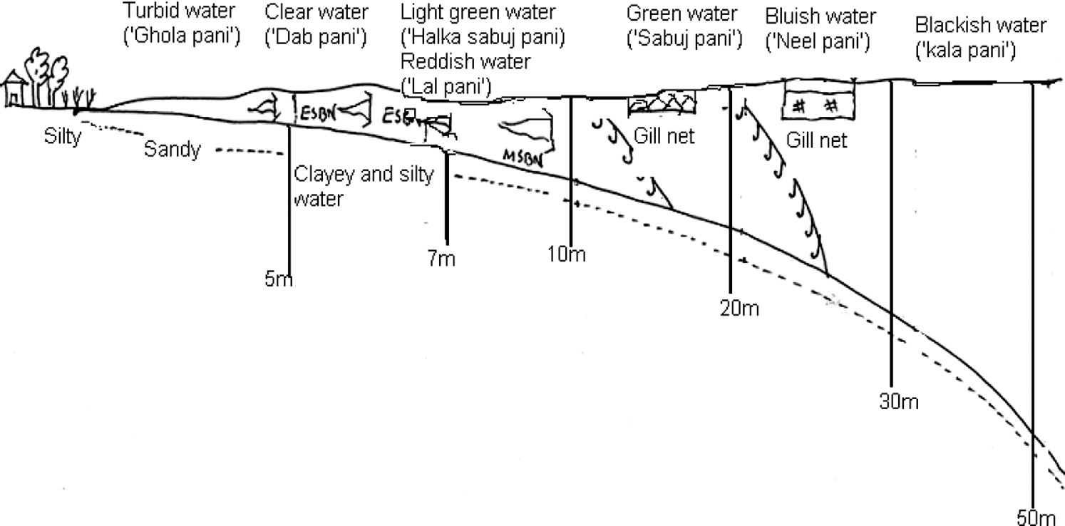
Fishers identify six types of water mass from the Bay of Bengal: turbid, clear, light green, green, bluish, and blackish water. Fishers perceive that the coverage and duration of certain types of water are strongly influenced by seasonality, depth zone, topography, fresh water influx, wind direction and velocity, and the semi-diurnal tidal pattern during the new moon and full moon tidal cycles. The southerly wind brings blue water near the coast, while the northerly wind does not usually affect the color of the water. With the turbulence of high tide, coastal water becomes muddy, while with the receding tide, it becomes bluish. Fishers hold that there is a depth-wise distribution of water types (Figure 4). Different species and size of fish and shrimp are targeted from each of these water types, using distinct methods of capture. For example, a green water mass prevalent along the Sunderbans mangroves of south-west Bangladesh is well-known for the prevalence of Hilsa spp., ribbon fish (Churi), and Bombay duck (Loitta), while the bluish water mass prevalent in the southeast St. Martin Island areas is targeted for Indian shad (Hilsa spp.), pomfrets, croaker, jew fish, Indian salmon, and tiger shrimp.
Horizontal distribution of water colors (Based on findings from focus group discussions with key informants from Thakurtala, Moheskhali Island, Cox'sbazar)
A reddish water mass occurs during the post-monsoon periods (6-30 m depth zone) in some fishing areas (e.g., off the south Sonadia Island, southwest of Hatia Island, Sandwip Khari, Meghna Khari, Gulitder, and Dulachira of the Sunderbans mangrove areas) (Figure 4). A bloom of phytoplankton (Asterionella spp.) might be attributed to localized formation of such a red water mass. Hindu fishers consider red water to be the sacred menstruation zone of the sea deity Ganga. The reddish water zone is specially designated as the dwelling area of Hilsa shoals. In such water, Hilsa fish are seen occasionally to jump on the surface; once their tails are seen, they dive to the middle of the water column. To target the water column, the steerer slows down the fishing boat to minimize the sound of the engine. He then picks up a bucket of water and smells it. Experienced fishers know that the presence of certain types of frothy and sticky/oily substances, and a typical smell of Hilsa mucus are indicative of Hilsa shoal. Prevalence of small bowl-shaped bubbles on the surface water is indicative of the presence of Phaissa fish shoal.
Fishers joke that the silver-colored Indian river shad Hilsa and pomfrets (Pampus argenteus) are “two sisters from the same mother” as they are found to roam together. Fishers consider Hilsa “naughty” as they tend to be in a sportive mood for a while when they are in a shoal. Shoals usually tend to form from fish of similar age cohorts. Fishers believe that Hilsa fish do not see the red-brown color in tyre cord nets and cotton nets, and hence, these nets are effective in catching Hilsa fish. One fisherman (Shukendu Jaladas, 55, Thakurtala) recounted: “Illish mach vashle shola, ar duble shil pathar,” which literally translates as “when Hilsa floats in the surface water, they are like foam (to mean, foolish and easy to catch), but when they sink in the deep water, they become heavy like a rock, meaning that they are clever, and hence, it is difficult to catch them.”
Conjugated water masses (Sangam or Milon Pani) are found especially in the shallow upwelling zone, especially with the heavy influx of turbid, rich floodwater when two separate and distinct colored water masses merge (Figure 5). One old Hindu fisherman told me that occasionally they see water masses so distinct in color and flow, that they can be compared to Devaprayag–observed at the confluence of two holy rivers Bhagirathi and Alakananda in the Himalayan region of India (Anil Jaladas, 63, Moheskhali). A wide variety of freshwater, brackish water, and marine species are found in the interface of Sangam water. Estuarine and marine set bag net operators and Hilsa fishers target such water masses. Fishers reported that such water masses proliferate with Acetes shrimp and smaller sized Bombay duck fish. The knowledgeable fishermen can detect such water masses in the sea from a distance of more than a kilometer. Fishers try to follow the maximum “line of penetration” of freshwater in the sea; they perceive that most of the brackish water fish species “love to visit” the freshwater zone or mixture zone at certain stages of their lives.
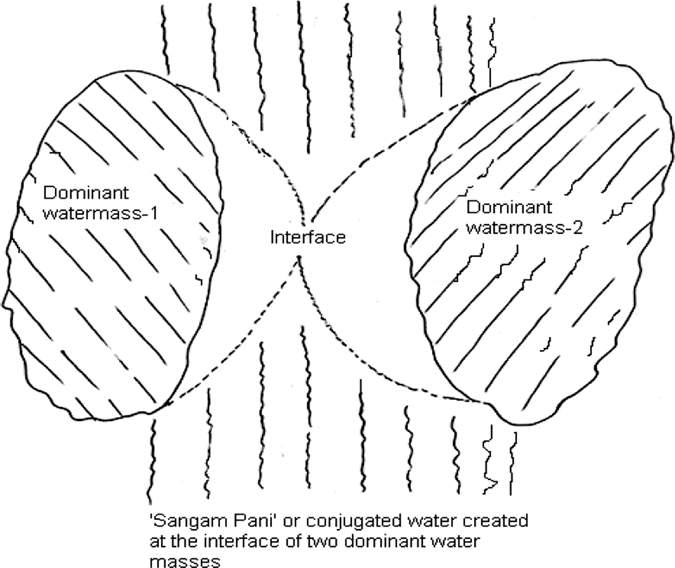
Sangam Pani or ‘conjugated water’ created at the interface of two water masses (redrawn from sketch by fishers of Thakurtala fishing village)
One experienced fisherman (Dulal Jaladas, 46, Gorakghata, Moheskhali) mentioned yellowish “Jaundice” Water. Fishers reported seeing this water mass in the Buriganga River contour line when they travel towards the southwest Sunderbans mangrove areas from southeast coastal areas. This might be attributed to the flow of water from the Buriganga River, which is known for pollution caused by urban sewage, industrial contaminants, and tannery effluents. Such water color is usually evident at depth of 5-7 m in Ashin-Kartik (the last half of September to the first half of November) months, characterized by the existence of seamount (Dubo Char) and strong turbulence. It is difficult to set ESBN or MSBN in the area during high tide but some ESBN fishers set their nets at ebb tide in the edge of the seamounts. Usually, limited numbers of banana and yellow shrimp, Acetes shrimp, jew fish, croaker, estuarine catfish, crab, and some other small fish are found in this yellowish water mass.
Many fishers came forward with another type of water color, Juni Pani (luminous silvery water), that is apparent only during the night. The word Juni originates from a luminescent insect called Jonaki. Some fishers believe that there are Jonaki in the marine water, but practically none could isolate or touch anything luminescent. The bioluminescence is presumably due to luciferin being oxidized in the presence of the catalytic enzyme luciferase by living organisms. A few expert Hindu fishers in a focus group discussion claimed to observe luminescence from small shrimp (Euphausids), jellyfish and squid. They also mentioned that luminescence is triggered by surface waves and movement of fishing boats. During the winter months, such silvery hues are more evident in all types of water masses except highly turbid water. Following the wind action on the surface waters, such silvery tones are seen. Fishers avoid silvery water with abundant jellyfish because they perceive that fish also avoid jellyfish.
One management implication is that the Department of Fisheries might identify the fisheries sites based on water colors and its seasonal variations, and develop plans for conservation of species at risk.
Weather, Wind Direction, and Current
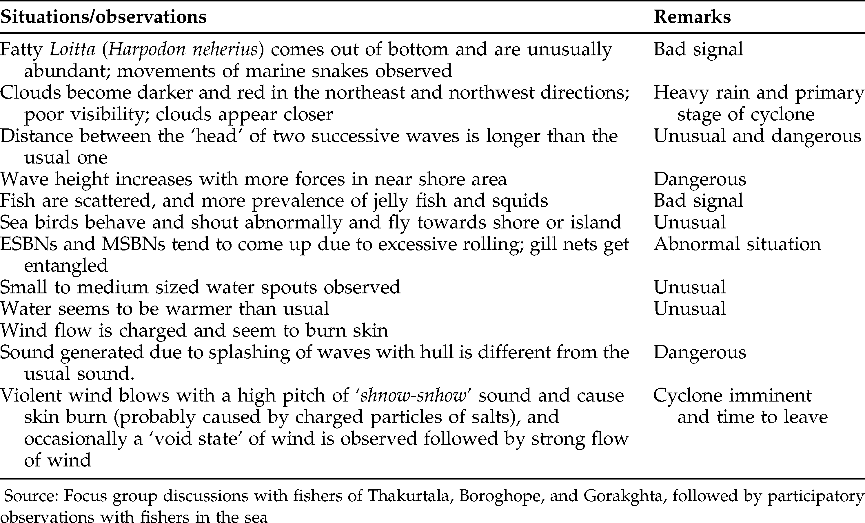
Torrential rain in the monsoons prevents fishers with manually operated craft from fishing in distant areas. Coastal fishers of the southwest and southeast coasts are the first victims of any cyclone in Bangladesh; most of them go to the sea devoid of basic safety items like gyrocompasses, buoys, radios, etc. Fishers make decisions about the advent of cyclone based on some visible (e.g., clouds), sensory (wind, heat), biotic (behavior of certain animals), and meteorological attributes (Table 1).
Some indicators of bad weather condition and cyclone in the Bay of Bengal.
Fishers pay special attention to wind directions and velocity. Wind from the north and east to west is good for fishers. With the southerly wind blowing from mid-March to mid-July, the sea remains ‘angry’ (Gorom), and only rain diminishes Bish (literally ‘poison,’ here to mean “force”) of storms and cyclones. A northerly wind (Uttarali) blows from mid-August to mid-March; after that the westerly wind begins to appear. Fishers reported the easterly wind (Pubali) appears at night from 10 pm to 7 am during the month of Falgun (mid-March); the westerly (Paschima Bayu) emerge in the daytime during the month of Agrahayan and for a few days at the end of February until mid-April. Hindu fishers believe the Uttaraly (northerly wind) starts with Janmasthami (sacred birth day of the Lord Sri Krishna as per Hindu mythology); this wind continues to blow from September to March (Bhadra to Falgun). Again, the southerly wind starts during Sripanchami Sarwashati Puja (Sarwassati is known as the deity of knowledge) in Magh (mid-January to mid-February) and continues for around seven months with strong effects from March to June. In almost all of the seasons, the majority of the fishers prefer to fish between depth zones of 3-20 m; this observation coincides with the fact that shallow waters are rich in food abundance compared to deeper water.
Fishers also recognize the importance of the four intermediate directions (Figure 6). Since Jom (a demon considered as killer of humans as per Hindu mythology; one of the worst curses in a fishing village is “Jom will meet you soon”) is associated with the south-east direction and known to cause the death of humans, the southerly wind is generally perceived as deadly to fishers (Nirmal Chakrabarty, 65, priest and village leader, Gorakghata fishing village, Moheskhali Island). Fishermen are aware that winds do not always necessarily blow in a straight direction; wind has a tendency to rotate or deflect. Wind direction and velocity change have an impact on fishing operations. Hook and long liners and Hilsa drift netters can put up with medium to strong current actions, while ESBN and MSBN operators would find it difficult to keep their nets in the fishing sites. Fishers observe the intensity of the prevailing wind. At the advent of a storm or cyclone, fishers note if the distance between two consecutive wave peaks becomes longer than usual (“dancing form of waves”). Hindu fishers believe that the “eyes” of the goddess Ganga (usually painted or engraved on planks in the front sides of the fishing boat) turn red, and a “thunderous sound” generates from the anterior side of the boat. “In such a situation, we are told by the deity Ganga to leave the area; we wind up and leave in Nimesh [literally, 1/450th of a second, as per the Bayu Puran of the Hindu mythology],” comments Sarathi Jaladas (54, Thakurtala fishing village, Moheskhali island).
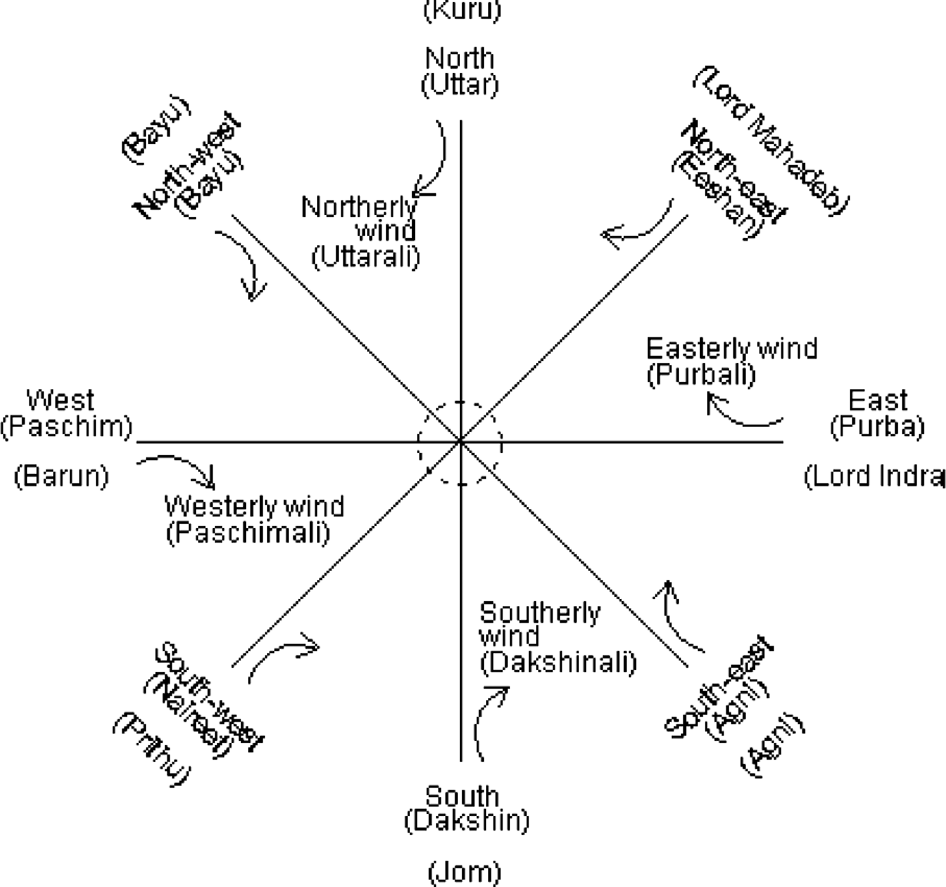
Locally recognized wind directions (based on sketch by key informants of Thakurtala village, and later validated with experienced fishers of the region)
There is a linear relationship between the current velocity and the availability of fish. ESBN and MSBN fishers mentioned that the stronger the current velocity is (of course within the tolerance limit for the net), the more fish are netted. Fishers observe sections in a gill net where fish are entangled the most. Based on the relative positions of fish entrapped in the net, fishers can assess the direction and location of the shoal, and they set their nets accordingly to maximize their catch (Figure 7). Experienced fishers believe that fish take the same direction of the cyclone pathway; shoals from deeper water appear close to the coast. This is why, following each major cyclone, the catch of Hilsa is known to be high in the near-shore areas, and the boat owners force the fishers (paid laborers) to go fishing despite huge risks to their lives and the associated psychological trauma they bear after seeing countless dead bodies in the coast.
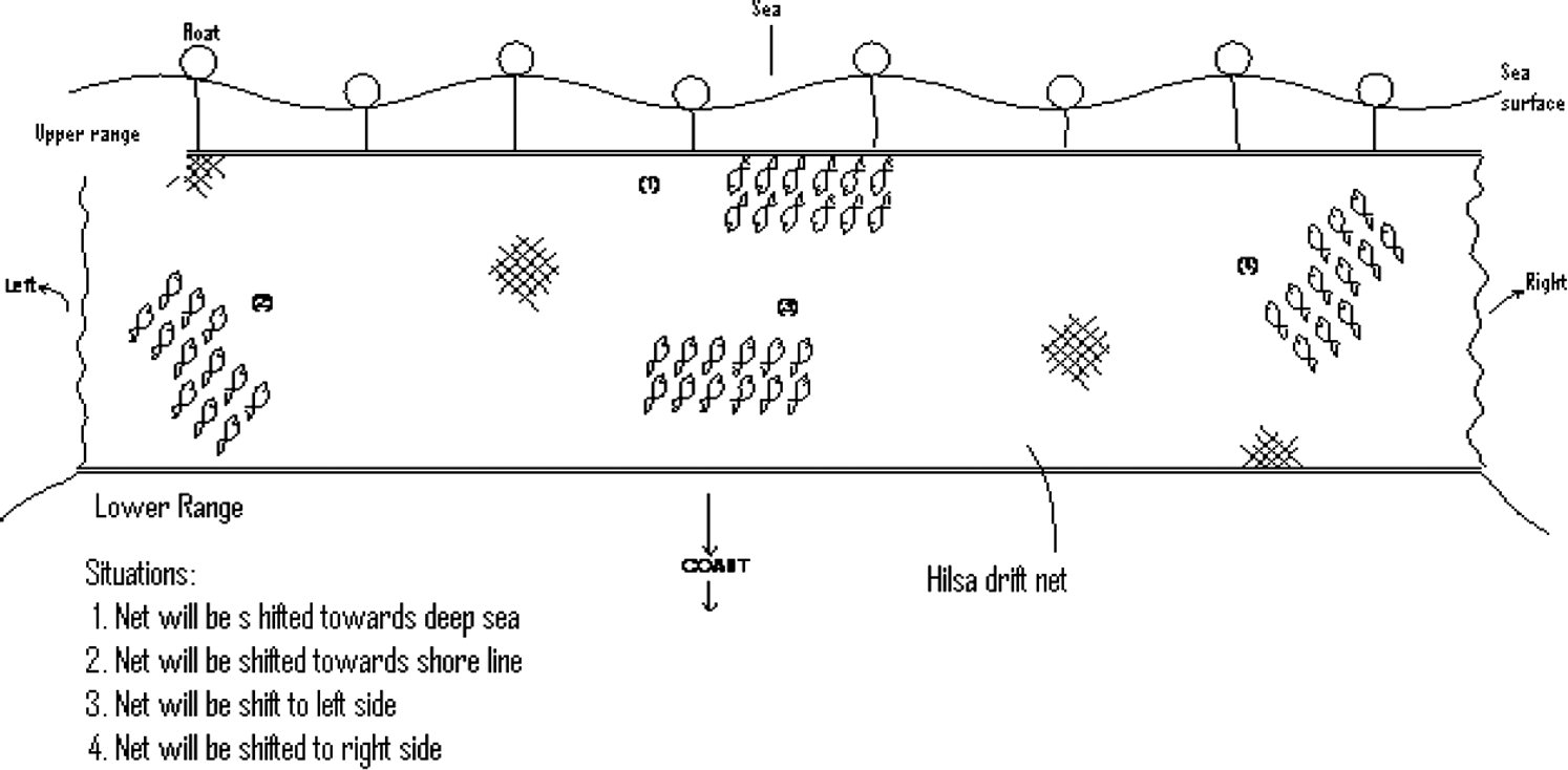
Diagram showing how positions of fish entangled in net helps in decision making about the probable location of shoals (Based on drawing by experienced key informants of Thakurtala village)
Fishers operating in the Gulitder and Bohoddar fishing sites know about the existence of unusual types of water (presumably underwater currents), which, when obstructed, would occasionally cause upwelling. Most of the fishers know the significance of upwelling (Utola/Tolar Pani). Old Hindu fishers perceive such phenomenon as the “movement of the Goddess Ganga underneath.” Fishers believe that upwelling brings food materials upwards, and thus leads to a good catch. Sea birds are seen to aggregate in upwelling areas. Reportedly, upwelling appears with the advent of the warm southerly winds; the water mass turns turbid for a few days followed by a change in color.
Lunar Periodicity
Marine ecologists have studied lunar or semi-lunar day rhythms of resident animals in the marine littoral area (Cordell 1974; Johannes 1981; Morgan 2004). Arunotai (2006) mentions that the nomadic Moken artisanal fishers of southern Surin Islands, Thailand, divide a month into “two waters,” meaning that there are two high water periods in each lunar month. Experienced coastal fishers of Bangladesh make their “mental fishing almanac” (lunar days known as Tithi) and day-to-day decisions about the duration and timing of fishing, species selectivity, area and depth of fishing, route of journey for fishing, and termination of fishing trip in harmony with the lunar periodicity. Fishers assert that certain marine phenomena occur with precise regularity during different cycles of the lunar month and the associated tidal pattern (Figure 8; Table 2). Fishers know that prawn migrate (“walk” in the fisher's term) through rivers and estuaries under the camouflage of the new moon darkness to avoid predators.
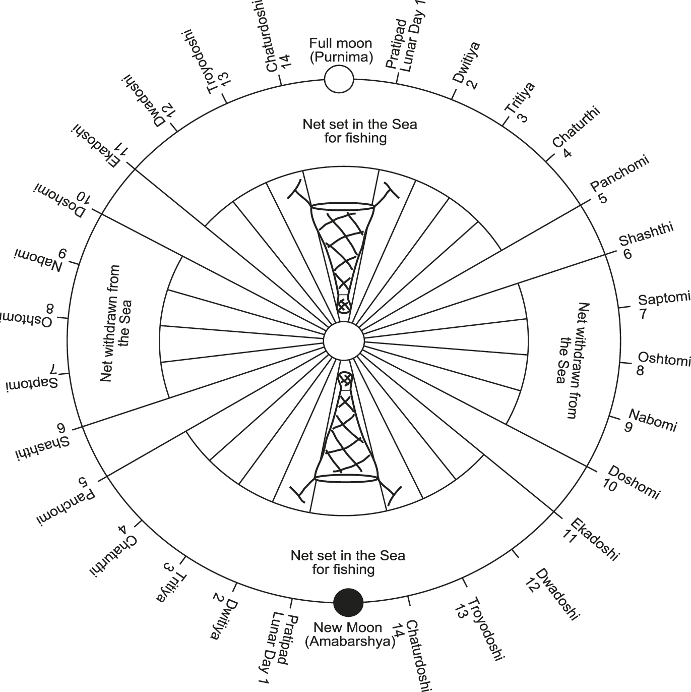
Schematic diagram of lunar days in relation to fishing operations (redrawn from sketch drawn by fishers of Thakurtala and Gorakghata villages)
Bengali lunar days and corresponding tidal condition.
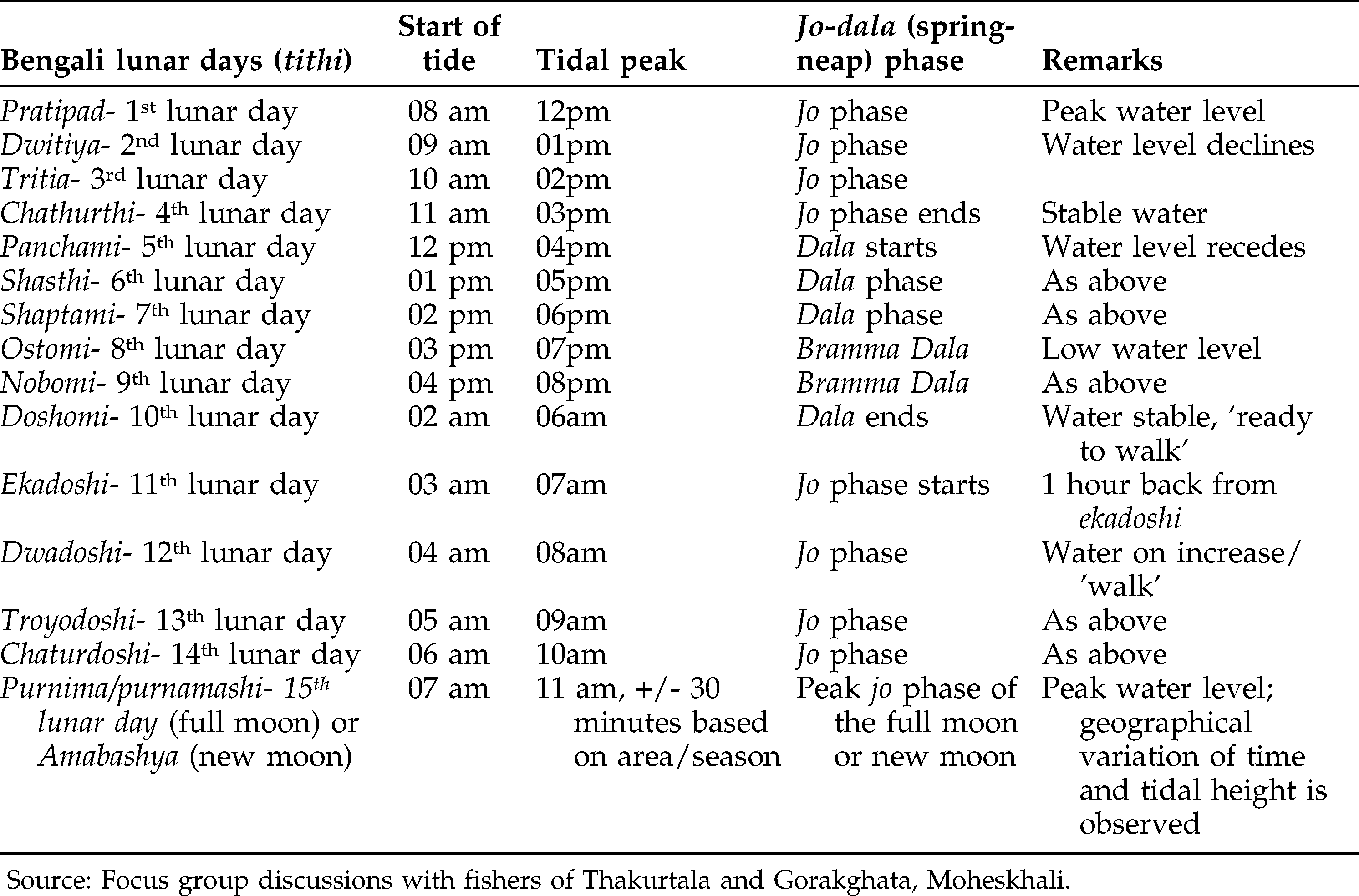
Coastal inhabitants of Bangladesh experience a semi-diurnal tidal pattern (two high tides or Joar, and two low tides or Bhata, in 24 hours). The local construction and understanding of the Jo (high water periodicity) are: Phulano Pani (flattened water), Vora Pani (full water), Beshi Pani (maximum water), Gorom Gaang (turbulent sea), and that of the Dala (low water oscillation) are: Kom Pani (less water), Thanda Gaang (quiet sea) and Taner Pani (receding water). Joar and Bhata are daily phenomena, while Jo and Dala are weekly to fortnightly phenomena. Fishers generally agree that, in a given lunar month, the tidal height and force during Purnimashi (full moon) is slightly stronger than that of Amabashya (new moon). However, the peak tides during the rainy season maintain similar heights irrespective of the new moon and full moon phases. Hindu caste-based fishers believe that in each Bengali lunar month, there will be two phases of Jo. In each fortnight, there will be 10 days of Jo (20 days/month) and 5 days of Dala (10 days/month). At least for fishing purposes, Muslim fishers do not comply with the Islamic 12-month calendar; rather, they decisively observe the moon's movement in compliance with the Bengali lunar months (Interview with Khorsed Majhi, a Muslim fisherman, Ahmediakata, Moheskhali).
Fishers observe that the elevations of tidal water “prior to” and “following” a full Jo of new moon phase (Amabashya) are higher compared to those of the full moon phase (Purnima). The availability of fish has a temporal dimension; fish abundance is higher during the Jo period than the Dala period. ESBN/MSBN operators and hook and long liners of the greater Moheskhali and Cox'sbazar region usually fish during the Jo and cease at the advent of Dala. In certain fishing areas (like the Kutubdia and Sandwip channel, and the Gulitder, Bohoddar, and Jalchira fishing sites near Sunderbans), tidal currents are exceedingly strong during Jo. Fish catch in these areas is higher during the Dala period than the Jo period with a sharp variation in catch composition. The tidal current during the Jo period is so strong that fishers cannot set their ESBNs or MSBNs in the coastal channels. The amount of fish caught during the Dala phase is insignificant in the Moheskhali region (see Figure 9).
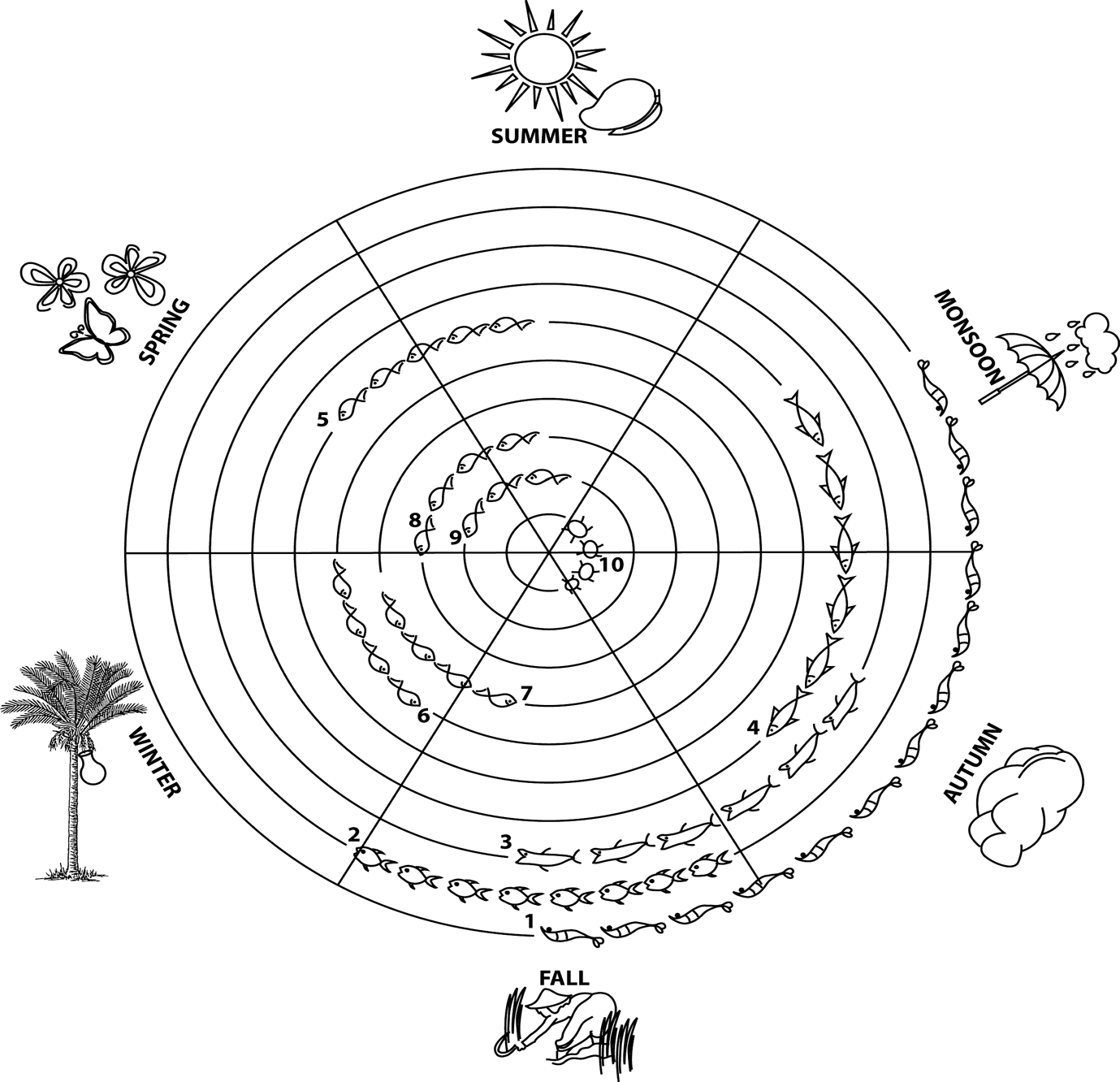
Seasonal abundance of fish. Legend: 1. Penaed shrimps 2. Iskiri (species composition unknown), 3. Churi (Lepturacanthus savala), 4. Loitta (Harpodon neherius), 5. Phaissa (Thryssa spp.) 6. Jew fish (Poa), 7. Pomfrets, 8. Bata (Mugil sps.) 9. Olua (Coilia dussumieri), and 10. Crabs
Based on the season and depth, coastal fishers either fish during Dala and wind up nets during Jo (in monsoon months), or maintain nets throughout both the Jo and Dala (in dry months). This trend has local variation (details in Table 3). As the Dala phase invites more freshwater influx to the coast, the likelihood of getting freshwater and brackish water species is high. Fishers mentioned that, in the first Ekadoshi and Dwadoshi (eleventh and twelfth lunar days) of the month, shoaling fish increase. Only a few other species (ribbon fish, snappers, croakers, threadfins, big eye tuna, and Indian salmon) of good size and quality are found. In the days following Voron Jo (tidal peak with turbid water), species like brown shrimp, kuruma shrimp, Bombay duck, green tiger shrimp, banana shrimp, kiddi shrimp, threadfins, and small croakers are caught more.
Variation in aquatic species caught using different gear during different periods of lunar cycle.
Fishers reported that in a particular fishing site if a good amount of larger-sized white ribbon fish (Churi) are caught in the net, hardly any fish of the same species will be caught on the following day. The reason behind this is not known. That is why with a bumper catch of white ribbon fish, fishers usually change the fishing spots. White ribbon fish is usually considered a fish of the Dala phase; they are found in less turbid water with lesser amount caught during the Jo. However, generally on the eighth and ninth lunar days (Ostomi and Nobomi) of the winter (Poush-Magh) months, there is hardly any catch in the ESBNs and MSBNs. Consequently, the fishers in the Moheskhali region usually wind up their nets for drying, treatment, or repair. One Bengali proverb states:“Ostomi nobomi bramma dala, Koi geli tui jailla hala” (literally, “The eighth and ninth lunar days are exceedingly dull; where do the foolish fishers go fishing these days?”). Government planners need to provide support for alternate income generation activities during these lean fishing days for livelihood sustenance of the poor fishers.
Expert fishers observed that the diurnal pulse has some impact on the catch and its composition. The Borshi (hook and long line) operators avoid the surface layer by the day and target the bigger fish staying at the sub-surface layer through a change in the line up (vertical alignment or horizontal alignment close to bottom). ESBN fishers netting in shallow waters have nothing or very little to do with such diurnal variation. However, the MSBN operators netting off the coast target the sub-surface layer by day and the surface layer at night. Hilsa netters have the operational advantage of adjusting their nets to different depths and at the probable locations of the shoal. Fishers agree that under any given circumstance, small fish dominate the surface layer in the daytime and medium to larger fish come to the surface layer from the sub-surface and bottom layers for food. “How do you feel if you are forced to look at the sun directly or somebody throws torch-light on your face? In the same way, fish avoid sharp sun light at daytime,” said Sadhon Jaladas (43, Thakurtala village).
Fishers, as well as the wider coastal communities, agree on the variations in taste of certain fish and other edible seafood. Mud-crabs captured during the full moon (Purnima) will be Fokfoka (whitish) and contain less muscle and eggs. Such crabs hold lower value in the market than those caught during the new moon (Amabashya). This is linked to spawning behavior and other metabolic processes of the species. Fishers said that the hair fin anchovy (Phaissa) of Rangabali Island, Loitta (Bombay duck) of Kutubdia Island and south Kattali, Icha Gura (Acetes spp.) of Moheskhali Island, and ribbon fish (Churi) of Sonadia Island and the Rangabali fishing sites are well cherished by the consumers. The management implication of these findings is that a detailed study needs to be undertaken on the plankton, benthos, and macronutrients and micronutrients of the soil and water of these areas.
Sediment and Topography
The erosion and accretion process is very dynamic in the Bay of Bengal. ESBN and MSBN fishers check the likely shape and elevation of the underwater topography (using a stone tied to rope). Experienced fishers mentioned that the topography of the sea is changing rapidly. Brajahori Jaladas (56, Ali Akbar Deil village, Kutubdia Island) adds: “siltation from land is heavily impacting the coastal topography. The coast line is becoming dangerous; numerous seamounts are emerging every year. The fish-rich edges known to fishers are also changing in terms of depth and location, and it is becoming increasingly difficult for fishers to keep pace with the change.” Such rapid changes in sea-bottom morphology as perceived by the fishers might be attributed to the increasing trend in global warming, deforestation of mangroves, and coastal erosion. Notably, the Ganges-Bramahputra riverine system discharges around six million cusecs (1 cusec = 1.699 m3/minute) of water from the upper Himalayan basin, with a sediment load of about a billion metric tons/year of continental sediments into the Bay of Bengal (Subramanian 1993). The management implication here is that government planners must consider a massive afforestation program in the coastal belt, and stop any development effort that would ruin the mangrove forest. The fishers interviewed did not explicitly mention global warming, but they assumed things in nature are changing rapidly. They observed that fish of all sizes roam along the edges (Dhair) of the seamounts (Figure 10). However, big fish that can withstand higher velocity underwater currents can be found along the deeper portion of the Khari (bed of the valley). Another possibility behind this judgment is that the edge with relatively flat elevation provides more room for feeding or grazing compared to that of a steep Khari. However, preference in targeting the area and depth varies based on gear and targeted species.
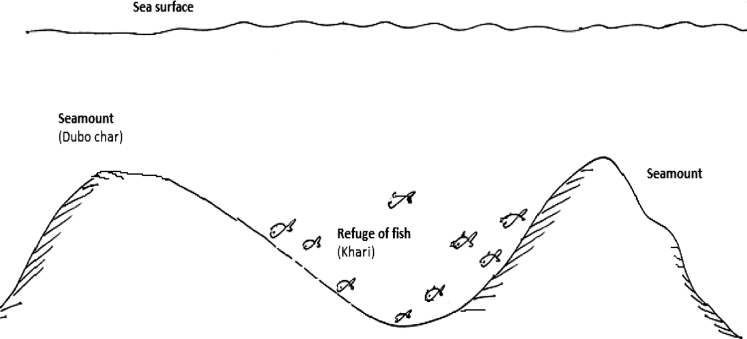
Schematic diagram of seamount (Dubochar and Khari) in relation to fish availability (redrawn from sketch drawn by key informant fishers of Thakurtala, Boroghope, and Ali Akbar Deil fishing villages, Moheskhali and Kutubdia Island).
Fishers also examine the mud content organoleptically. Fishers discussed sandy (Balu Mati), gravel rich (Pathor Mati), clayey/muddy (Kada Mati) and slightly silty (Moina Mati) mud. Sandy mud is reported from coastal areas near sandy beaches and off the St. Martin Island. Clayey mud is found beneath red water, greenish water, and turbid water masses and characterizes most of the important fishing sites. Fishers can analyze the mud content using their fingers in situ and instantly find out the type. In one journey, I asked an expert Majhi (Nilu Jaladas, 52, Thakurtala) how he determines the mud type and quality. He instantly made two rings out of the soil contents; one showed minor cracks on the periphery (decision: sand rich) and the other did not (decision: muddy, silt rich). Fishers mentioned that fish do not inhabit a sandy zone with the presence of “silvery mottles.” They mentioned that Hilsa fish prefer soft blackish mud for their food. “Blackish mud can even be devoid of fish; some riverine and coastal areas with big industries, municipal pollutants, shrimp hatcheries, etc. are like deserts. This black mud is malodorous and poisonous to fish” (Nilu Jaladas, 52, Thakurtala). The soil and water of the estuarine areas receiving untreated industrial effluents deserve a thorough study from the viewpoints of toxicity and its impact on flora and fauna. The government must consider putting in effluent treatment plants in all coastal and urban industrial areas to reduce the negative impacts of freely discharged sewage and industrial contaminants.
Traditional Celestial Navigation
Sukh tara tui sukh dilina amare; amar jonom gelo sagar tire, dekhte tore dui noyone (Oh my Venus, you did not add happiness in my life; I spent my life on the sea observing all the stars)
—A folk song commonly sung by the traditional fishers
The artisanal fishers of the southeast and southwest coastal regions have intricate navigational skills; they do not use any compass or any other basic navigational equipment. Few fishers (except steerers) can afford to wear a wrist watch. Fishers use both static (e.g., location of islands) and dynamic (e.g., position of stars) information to calibrate the relative position of the fishing boat in the sea, keep track of mental calculations, and make course adjustments in reference to target locations. Similar to the Carolinians of Micronesia (Goodenough and Thomas 1987), coastal fishers of Bangladesh evaluate imaginary places as points of references for steering along with real ones.
Through a series of sea voyages with fishers, I observed mental calculations of voyage time, directions of the fishing spots, relative positions of seamarks (such as islands, swimming directions of dolphins and flying fish, water color, depth), hill-marks, and the location of stars as points of reference. Fishers travel 200-400 km from coast to coast (southeast to southwest) and 30-70 km from the coast to the sea. From sea to coast-bound journey, fishers first look at the movements of birds, followed by hill-marks or islands. They depend considerably on the relative locations of different stars seen in different months for setting the direction.
The duration of the journey is important in making decisions about location. Time needed for the journey from a fishing village to fishing sites or vice versa varies from boat to boat (based on type of operation and engine capacity). Cosmological knowledge, developed through years of empirical observations of the astronomical system, plays an important role for the sea-faring fishers. Fishers are oriented on the rising and setting points of some specific stars and constellations (usually those that are bright and the most conspicuous). Stars that bear immense cosmological importance to fishers (irrespective of castes and religious identity) are: Shukh Tara (Venus), Dhruvo Tara (North Star), Adam Surot Tara, Sandhya Tara (literally, evening star), Puber/Pub Aksher Tara (literally, eastern star), Sath Bone Tara (literally, Seven Sisters constellation), and Rahu Tara (literally, demons’ star).
Fishers mentioned that the Seven Sisters appear in the east corner during the month of Ashin (late September to early October) and set in the west; they believe that Rahu Tara is known to be always behind the Seven Sisters with bad intentions of immoral teasing and masculinity. Dhruvo Tara is seen in the northern sky, Sandhya Tara appears in the western sky at early hours at dawn, and Puber Tara appears in the eastern sky. Old Hindu fishers believe that the mythical hero Dhruvo was blessed by the God Narayana, and placed in the sky at a fixed place in the north so that he can easily glimpse the Narayana. They gauge their direction by looking at Boro Ekprohora Tara. If a helmsman starts from the deep sea towards the coast, he keeps navigating while keeping the location of Purber Tara at the center, and then he can reach Cox'sbazar or Teknaf. After locating the light house of Cox'sbazar, fishers can find other points.
Fishers mentioned that the Suktara appears by 2-3 am in the late night. This star indicates the sunrise period. After the setting of the Sandhyatara by 8 pm, the Borotara appears in the sky; when the Borotara sets, the Suktara appears. The Seven Sisters will be in the sky almost the whole night; they appear around midnight during the month of Kartik (mid-October to mid-November), and after that they will not be seen well because of weather conditions. The Borotara will be on the head (straight upwards) from the month of Falgun (late February to early March). Keeping two Doarika Tara of the south on the left side of the boat, when one navigates from the Moheskhali channel, one will find oneself in the Dhair (sealanes/roads/fishing sites). Fishers calculate the journey period in such a way that after reaching the targeted fishing sites, the peak tide becomes neutral. Then they gather the fish from the net and come back.
Keeping Satbone Tara (Seven Sisters) on the right hand side, if one starts from deep sea, one will be in between Cox'sbazar and Kutubdia Island. Then looking at the lighthouses of Cox'sbazar (counter-clockwise) and Kutubdia (clockwise), one can decide about destination points. I asked some experienced fishers what they do in a cloudy night when stars are not visible. I was told that they are at least aware of the sunrise and sunset directions, and from an angular position, they can ascertain other directions tentatively. Then they can ascertain locations based on hours of voyage in a particular direction. In the case of a puzzling situation, the steerer usually consults senior crew members who have fished in those particular sites before.
Sea swells and the directions they are coming from are also keenly observed when fishers are at sea, and especially when they are lost. The strength and direction of currents is an important attribute in the decision making process. It is known that the high tide (Joar) has a shoreward direction and the low tide (Bhata) has a seaward direction. When anchored, the anterior side of the boat might be oriented by the tidal flow. The management implication of these findings is that an easily comprehensible, pictorial navigational chart can be developed using fishers’ vocabulary for use during fishing voyages.
Birds and Animals
Local fishers noted that four categories of birds, represented by several species, were important (Table 4). Fishers observed that these birds prefer small fish that fit with their beak size. Expert fishers mentioned that with the prevalence of certain types of birds, it is not possible to precisely predict the abundance of certain types of fish, although sometimes some correlations can be made. However, they agree that in certain areas, an aggregation of birds is indicative of the presence of fish irrespective of species. Then a decision is drawn based on the earlier experience about the location, depth contour, water color, and mud type.
Birds of significance to coastal fishers.
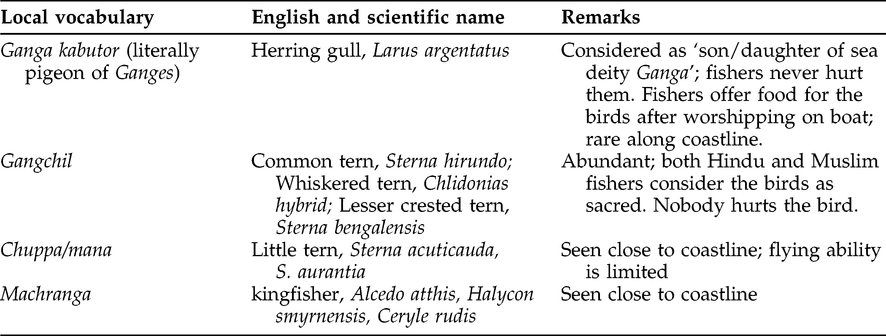
Ganga Kabutor (pigeons of the Ganges; black-headed gulls, Larus spp.) are usually considered to be passive hunters; they do not actively prey on small fish. They gather fish discarded by fishers or which come up on water surface from the ESBN or MSBN meshes, or after being injured by the propeller of the fishing boats. Fishers assume the availability of fish in a certain area if a flock of birds play for a long time, happily spreading their wings, and jump on fish from an angular direction (not straight from above). Some fishers related birds’ abundance with the presence of Hilsa spp. in reddish water zones. These birds do not immerse their whole bodies into the water, but only the thoracic part when necessary. Usually, they do not attack or injure bigger fish, even when they are found in nets.
Some fishers claimed that Ganga Kabutor displays the shoreward direction when somebody is lost, but there are fishers who did not agree with this perception. However, the bird is significant to fishers in locating the direction of the previously set nets, as the birds are usually found to congregate by or around the nets looking for dead fish. It is also helpful in determining whether the net is up and ready for harvest. One expert fisher commented:
Ganga Kabutor is usually seen between the months of Ashwin-Kartik and Baishak. Nobody knows where they go at other times; maybe to the Andaman Islands as we knew from our forefathers. We have neither seen copulation nor any small sized bird here. When female's head and thoracic region turns black from reddish color, we guess that they are bearing eggs; the birds look fatty then. They eat twitchily (around 2-2.5 kg/day) and release stool often. They prefer whitish small fish like samudrik moilla [Escualosa thoracata] and usually avoid the jellyfish and squids. The eggs mature with the southerly; so when we see the black-headed birds, we believe that the southerly is approaching. With or before northerly, the females leave for laying eggs. As the peacock spreads its tail in monsoons with thunders, in the same way a thrill is noticed in their body with the advent of the southerly (Avimannuya Jaladas, 53, Thakurtala village).
These observations bear immense significance in terms of regional migration of the bird and also for forecasting the prevalence of the southerly wind in the Bay of Bengal, which is assumed to be deadly for the fishers. Fishers can then make their mental map accordingly.
Kingfishers (Halcyonidae) roam in shallow waters; fishers did not see them fly far towards the deep sea. Whenever the kingfishers flock together and continue hunting for a long time in a certain area, fishers decide to target the area. Kingfishers, as active hunters, can track and hunt fish from a height of 20-30 m. Fishers put little attention to sporadic hunting by birds. Fishers described that Chuppa Mana (Sterna spp.), though a small bird, can hunt actively from a height of 5-10 m; they can penetrate 0.5-1 m inside water, and they balance the dive by spreading their wings. A few birds seen chasing fish is not helpful in decision-making by fishers. But sometimes they are found to follow a Dhair (a line or small shoal of fish; birds follow the shoal in a straight line). Fishers target such areas. The Chil (osprey) is observed as a lonely hunter, usually targeting small to medium sized fish in the shallow waters and mangrove areas. Their hunting styles bear no special significance to fishers.
The use of otters in fishing is recorded from the southwest of the Bay of Bengal. One fisherman of Thakurtala, who goes to the Sunderbans mangrove forest areas for six to eight months as a paid laborer adds from his experience:
Otters are very clever; they are like other pets. Fishers keep two to five otters in cages on the boat. As they set the net, they release the otters in water. The otters drive the fish from surrounding areas towards the boat/net; this is how much more fish are expected in the net compared to those without otters operating in the same area. After each haul, the otters are honored with small fish. They know their owners and are treated like sons on the boat. Otters are trained by fishers and sold locally as a fishing aid (Jonardhan Jaladas, age 55, Thakurtala).
One expert fisherman (Kartik Jaladas, 67, Gorakghta village) told me about the significance of the river dolphin, Shushuk (two subspecies known so far, Platanista gangetica gangetica and P. g. minor), to the fishers. Fishers used to follow them in the riverine areas of Karnafuli and Sunderbans. The roaming area of dolphins is considered to be rich in prawns, small carps, and catfish. Fishers offer them sacred items like rice and ripe banana after a prayer on the boat. It is claimed that dolphins know how to avoid fishing nets; even if the animals are entangled, they are released right away by fishers. He claimed that dolphin population is declining sharply because of rampant, untreated industrial effluents.
Mangroves
Mangroves play a motherly role for fish and shrimp; there is an umbilical cord relationship. It absorbs all our sins. Nobody remains hungry in a mangrove-rich area; mangroves provide at least something for everybody in a number of ways…as the size of mangrove areas is squeezed, our livelihood opportunities also become threatened (Arati Bala Jaladas, 47, Thakurtala, Moheskhali Island).
Words like pera, perabon, kerpa, kerpa bagan, and kerpabon are synonyms for mangrove forests. Old fishers claim that, historically, the human settlement patterns and the very existence of most of the coastal fishing villages of the south-west have been linked to the abundance of mangrove forests (Figures 11a and 11b). Relatively more fishing sites are located in the southwest part of the Bay of Bengal (Figure 12), which correlates with the presence of one of the largest mangrove ecosystems in the world—the Sunderbans (beautiful forest).
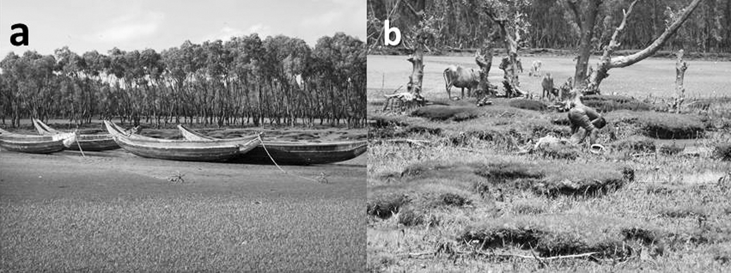
a, Mangrove forest off the Thakurtala village during high tide; b, mangroves during low tide used for crab gathering and grazing in the coastal area
Fishing sites and grounds as gathered from a series of focus group discussions at Thakurtala, Gorakghata, Maijghona and Boroghope fishing villages
Fishers have thoughtful understandings of the critical significance of mangroves for fish and crustaceans. They observed that some species like shrimp spend their almost entire lives for refuge, food, and nursing in the mangrove areas, while others (like freshwater prawn) show facultative dependence or preference for mangroves areas for food and reproduction. The mangrove forest is believed to be the host of most marine and brackish water fish for at least certain stages of their lives. Fishers call the mangroves Mar Koler Dolna (mother's cradle) for small fish. One old fisherman had a cautious interpretation: “Fish usually found in a different habitat go there for pilgrimage and a honeymoon; they pass happy time there with food, amusement, and a nice environment” (Sadhan Jaladas, 49, Thakurtala village).
Mangroves serve the fishers in a number of ways (Table 5). All the fishers I interviewed agreed that there is a positive relationship between the density of mangrove forests and the availability of fisheries’ resources. Many fresh water species are found there in low saline zones. Many freshwater species are commonly found along with the marine species. Fishers regret that the Chakaria Sunderban, one of the oldest mangrove forests of the South-Asian continent, was clear-cut for boosting shrimp culture as a World Bank project. This had negative repercussions for local fishers whose lives and livelihoods depend on the very existence of mangrove forests. Notably, climate change might impact the growth and abundance of the coastal mangrove forests directly and indirectly, with simultaneous impacts on the resources therein.
Multiple uses of mangroves as viewed by fishers.
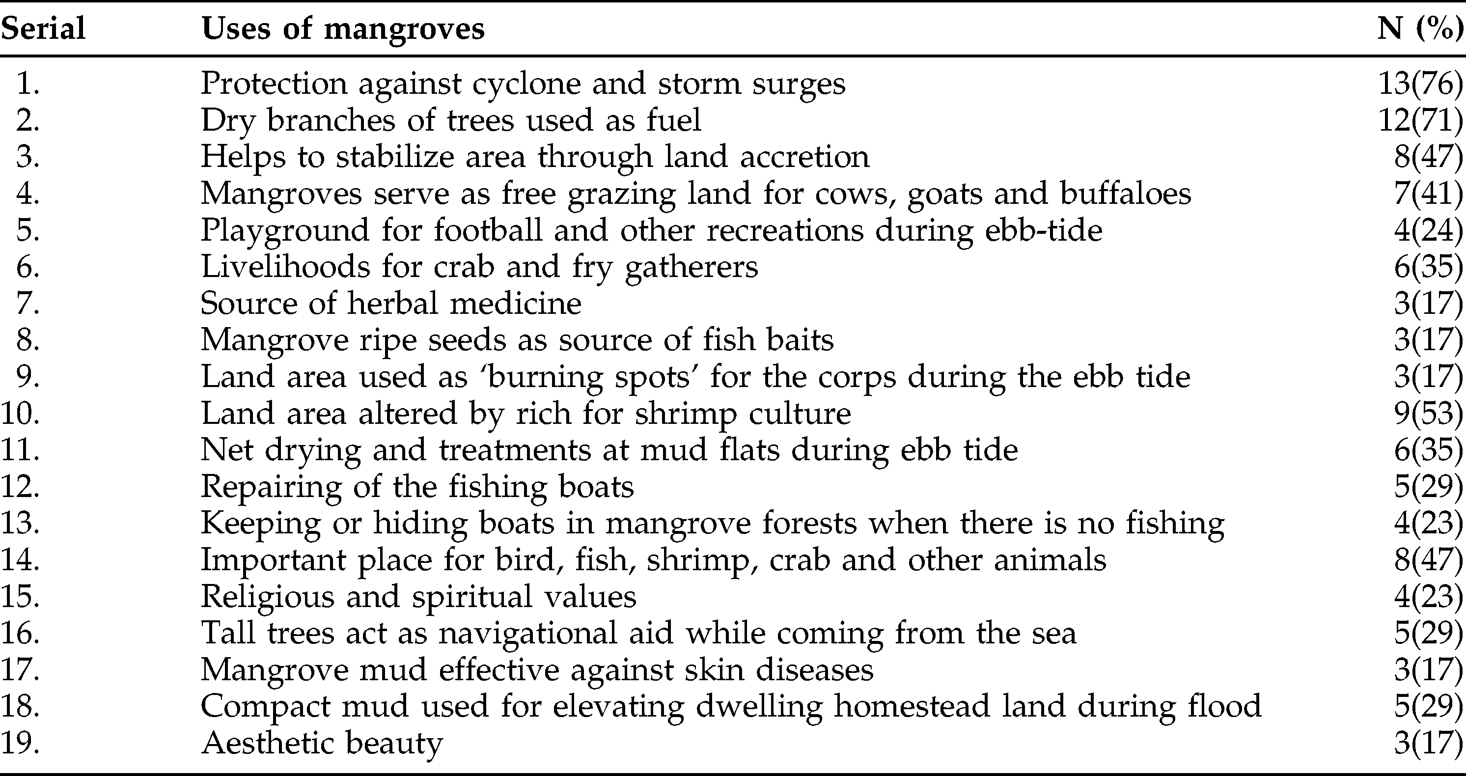
Fishers observed that domestic animals (like buffalo, cows, goats) usually eat small saplings and green leaves, but avoid mangrove seeds as these are usually sour and cause “bowel syndrome” to animals. This helps protect the seeds. Thus quick expansion of mangrove forest becomes possible. The management implication of the conservation of the mangroves is far reaching, and clear-cutting of mangrove forests should never be allowed in the name of any development intervention.
Fishing Sites
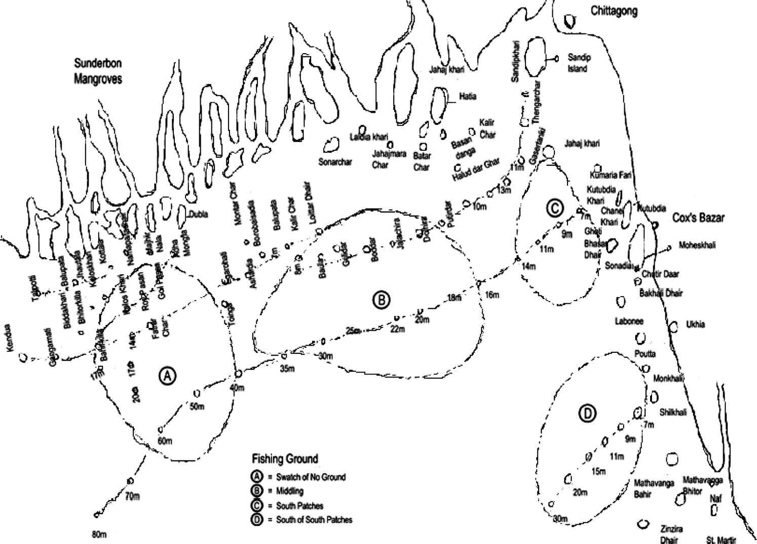
In the past four decades, several scientific studies in the Bangladesh fishing territory found the existence of four fishing grounds (1. Swatch of No Ground, 2. East of Swatch of No Ground, 3. Middle Ground, and 4. South Patches) (Figure 12). None of the fishers that I met in the greater Cox'sbazar and Chittagong districts knew these official names of fishing grounds.
Fishers described more than 50 fishing sites (Figure 12); some are parts of the officially recognized fishing grounds and some are not. Some sites are espoused with local names while others are connected to the depth contour (in terms of meter/Bam). The fishing sites mentioned by expert fishers are smaller than the officially recognized fishing grounds. The fishing sites have separate importance to different fishing groups; some fishing sites have attained more of a reputation than others for the abundance of specific fish. Some spots are overfished while the deeper sites remain underfished. Expert fishers know well that each site is characterized by different combinations and seasonal variations of water color, sediment type, bathymetric relief, depth, intensity of current flow, availability of plankton, faunal assemblage, etc.
Caste-based Hindu fishers have an age-old territorial management system called Faar, through which fishing entitlements over certain fishing spots are granted to community members, and such a locally crafted system is important for subsistence strategies, sustenance of indigenous culture, TEK, social identity, equity, and a sense of belongingness. Through the Faar system, hereditary fishers have been able to establish de facto fishing rights over some fisheries’ micro-habitats located close to their villages (see Sims and Deb 2009 for details). This local level territorial system is not legally recognized, and hence subject to increasing pressure from competing fishers from other villages. Policy makers should take into account the fishing sites identified by fishers, and carry out a detailed study on species composition and stock assessment.
The Significance of Traditional Ecological Knowledge: Decision-Making at Sea
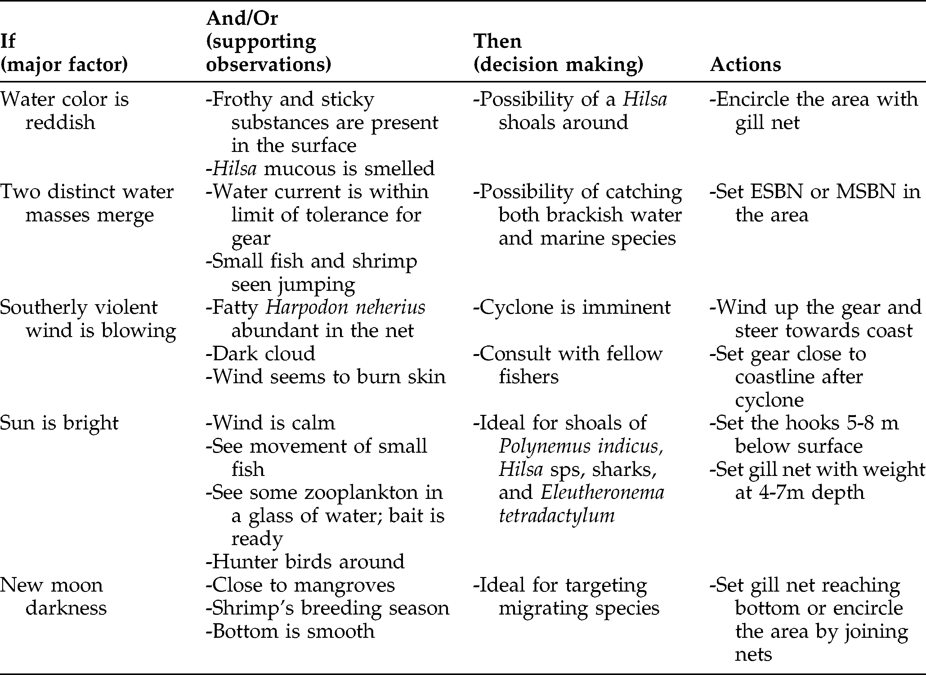
Making a decision about the operation of gear at certain site and depth is not an easy task. There are variables that fishers control (e.g., selection of gear, site, time of voyage, type of bait, and depth at which gear to be set), while there are some others which might behave in an unpredictable manner (e.g., wind velocity and direction, movement of fish, impact of lunar periodicity, and diurnal variations). Expert fishers make their judgments based on these sets of known and unknown variables. This is what follows the heuristic rules of IF (a given situation or a major factor) and THEN (some likely outcomes) proposed by Mackinson (2001) (Table 6). Expert fishers learned such abilities of decision making after decades of experimentations and observations in the sea. This involves a learning process of which decisions made in situ worked well, while other techniques failed to ensure a good catch. Thus fishers adopt new techniques for maximizing catch, and reject some unsuccessful strategies. It is a true form of adaptive learning.
A few examples of fishers’ decision making process in the sea based on different parameters and observations.
Such a knowledge-perfection process is an ongoing activity, and continues for generations. In a fishing trip off of Moheskhali Island, I saw a grandfather yelling at his son in front of his grandson. Fishers never had any formal/institutional training on fishing in the open sea; they learned through their own culturally defined observations on ecological clues and fauna, by trial-and-error in deliberate experiments, and sharing of information with older fishers (family members and relatives).
Knowledge Transmission
TEK, as an experiential and culturally constructed form of procedural knowledge, is transmitted through storytelling, physical participation in related activities, rituals, and other methods that engage the emotional, aesthetic, and physical as well as the cognitive domains of experience leading to total-person learning (Anderson 2011). Knowledge transmission, as a socio-cultural phenomenon, is expedited through interactions and networking with people holding a similar worldview. Fishers share their information on catch, weather, security, and other relevant issues with moral friends or cluster members to the extent that the information provider is not affected economically. However, certain forms of indigenous knowledge are not shared publicly; rather their transfer is limited and controlled. “Not everything is shared; something is sacred, something is secret,” said Nirmal Chakrabarty (65, priest, Gorakghata).
A young fisherman becomes an expert fisher after years of fishing voyages in the sea. An expert fisher can be identified by his face—his skin becomes darkly tanned because of years of burning under the bright sun; his eye cavities have deepened gradually because of the restlessness and anxiety while at sea, and his hair and beard are dry and grey. Here is a comment:
There is a relationship between fishers’ hair color and their knowledge about the sea. You know that a young fisherman with black hair is a learner, one with some grey hair has learned well, and there is no question about the wisdom of one in fishing profession who has mostly grey hair on his head (Sitaram Jaladas, 56, Thakurtala, Moheskhali Island).
Based on my participant observations and interviews with some key informants, here is a sequence of learning and knowledge transfer:
At 2-4 years, children make observations on living and dead aquatic organisms, and slowly pick up the local names of species;
At 5-7 years, they develop a sense of mental maps and romanticism about sea/coast through story telling by elders;
At 8-10 years, they participate with elders in post-harvest activities, local marketing, and the gathering of organisms (crab, shrimp fry, small fish, etc.) from shallow inter-tidal waters;
At 11-13 years, they know techniques of weaving/knitting nets, participate in boat repair, row small country boats, and can dive and swim;
At 14-25 years, they actively and independently participate in gear setting, fishing in nearby coastal and marine sites as paid laborer; and
At >25 years, they learn by doing and perfect their knowledge (Figures 13a, 13b, 13c, and 13d).
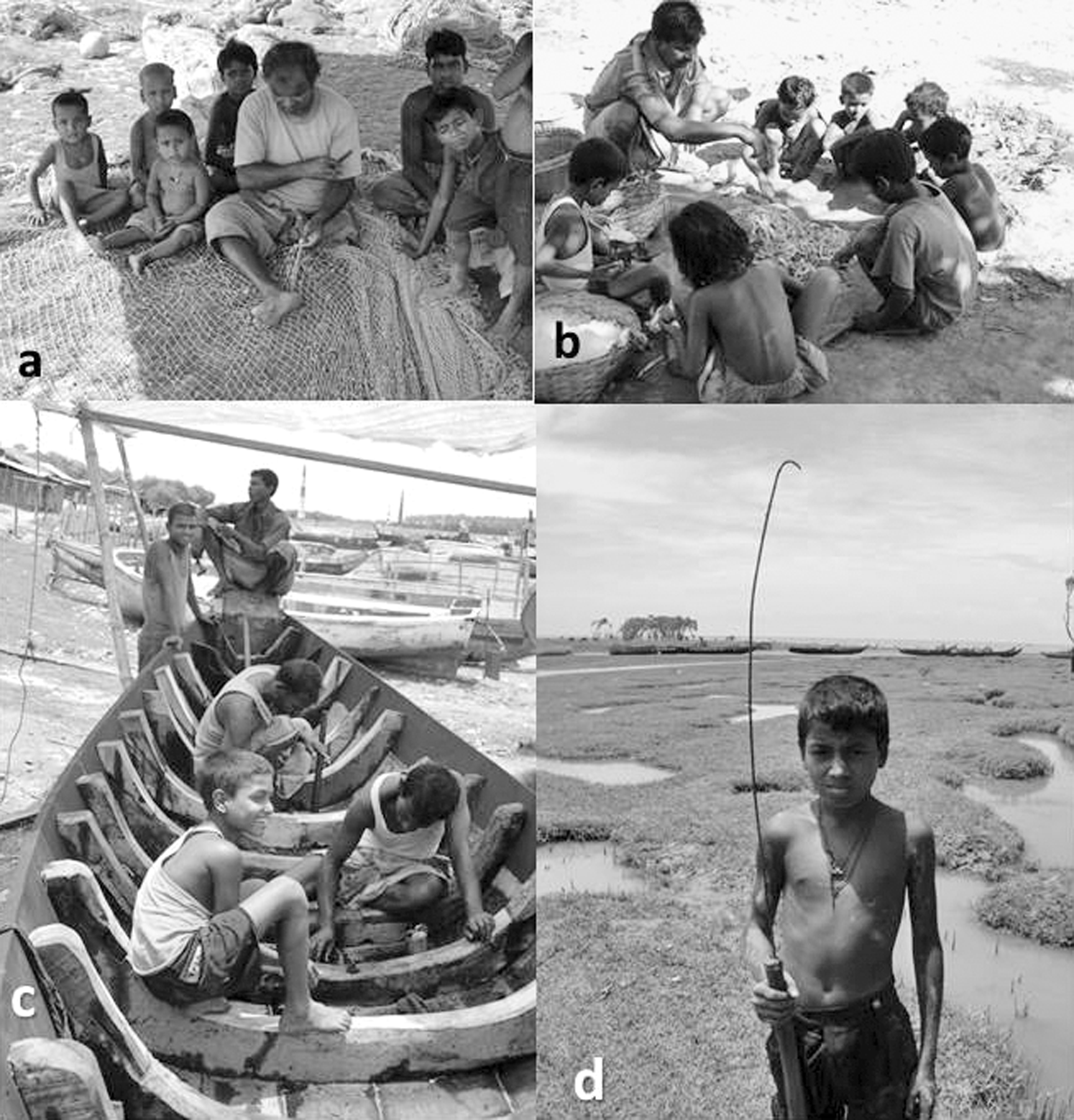
a, An adult fisher weaves net and children watch the art; b, Boat repaired by expert fishermen and boys also participate; c, Fish segregation under guidance of an adult; and d, A boy (age 10) starts independently with a little crab fishing tool
Old Hindu fishers view “knowing and doing” as something limited to the psychomotor relationships of the hands and the head, but real knowledge or wisdom is closely connected to the “hand, head, and heart” and something even beyond, that would be linked to transcendentalism, spirituality, and divinity.
The traditional fishing community and the environment they live in is such that they get up, work, eat, and sleep in a “fish-smelling” environment. The old fishers perceive an “umbilical cord relationship” between caste-based fishers, fish, and the sea. One fisherman's comment regarding knowledge transmission:
There is no school for such learning; there are neither paid teachers nor any learning equipment. It is in the blood and tradition…fishing villages and the sea is the ‘open school’ to learn. As there is a syllabus for gradual learning in school, there is also something systematic for the learners which no one sees…young fishers become knowledgeable and experienced after years of trial and errors. To us the thought for food and survival is the quick driver of learning (Kalamohan Jaladas, 57, Moheskhali).
This quote tells us that the fishers learn as part of their survival strategy rather than mere natural curiosity. A livelihood crisis can act as a pitiless trigger; boys in their early boyhood learn that early income is of critical importance for dealing with ruthless poverty, and there is no other alternative left in the vicinity than to be prepared mentally and physically. Some Hindu fishers feel a kind of compulsion to make their successors equipped with sufficient knowledge, as fishing is still considered to be the religiously and culturally bonded occupation for the low caste Jaladas groups. Gender plays an important role in the transmission of knowledge.
Conclusions
The need for sustainable management of small-scale marine fisheries in Bangladesh is critical for the overall economic development, food security, and the livelihoods of the millions of poor fishers. This rich heritage of TEK of coastal Hindu fishers is diachronically developed, experientially refined through observations and experiments in the sea, accumulated in the socio-institutional memory of the fishing communities, and culturally transmitted over generations. It is of immense value for fisheries’ resource planning and building resilience of the fisheries’ system.
Bangladesh generally lacks chronological baseline data on fisheries that could be used as an important source of information to manage fish populations. For instance, in the last two decades, there have been no extensive fisheries surveys in the Bay of Bengal, meaning that the standing stock and maximum sustainable yield values are unknown to policy makers. This rich and applied knowledge content of the traditional fishers reported here could serve as a vehicle for coalescing fishers’ opinion with the resource planning process which is, right now, solely based on conventional scientific knowledge. What is alarming to note is that in such a vacuum of reliable information on standing stock, the Fisheries Department issues fishing licenses to non-fisher elites mainly out of political consideration. Such deep-sea trawler operators, naturally having no commitment to sustainable resource management, fish recklessly often in the shallow coastal areas threatening the very existence of the artisanal fishers.
The Marine Fisheries wing of the Government of Bangladesh needs to start a fruitful and extensive consultative process with the local fishers regarding the management of aquatic resource in its territory. Although the Department of Fisheries revealed success in protecting some Hilsa spawning and nursing areas in the riverine zone through imposing restrictions on fishing in certain months, no such steps have been taken for the protection of marine fishing grounds and vulnerable fish species (Interview with Dr. Dilip Kumar, Fisheries and Livelihood Expert, FAO, January 16, 2014). However, success in managing Hilsa in the Bangladesh territorial part alone is not enough. Hilsa, being a transboundary fish found in the rivers and deep-sea territories of West Bengal, India, and Myanmar, deserves similar management actions by countries surrounding the Bay. Input from fishers’ expert system would go a long way in developing a regional management plan for managing important transboundary commercial species in the region. The Government of Bangladesh and its international development partners would do well to take a holistic approach of interactive resource governance through partnering with fishing communities in deliberations over the future of the artisanal fisheries sector.
Footnotes
Acknowledgments
I am grateful to the traditional Hindu fishers of the Moheskhali Island and some other fishing villages on the southeast coast, the poets of the sea. I would like to thank Drs. Eugene Anderson, Emeritus Professor, University of California, and Dana Lepofsky, Professor, Simon Fraser University, BC, and Editor of the Journal of Ethnobiology for their encouragement and guidance in revising the manuscript. Special thanks to Dr. C. Emdad Haque and Dr. Fikret Berkes of Natural Resources Institute, University of Manitoba, Canada for their guidance and suggestions during the study. Sincere thanks to Dr. Dilip Kumar, UN-FAO Fisheries and Livelihood Advisor, who taught me how to work with the fishers at the grassroots level.