
Abstract
Fuzziness widely exists in most of spatiotemporal applications, but the existing spatiotemporal data models cannot support representation of fuzzy spatiotemporal objects and their semantic relationships. In this paper, after investigating the semantics of fuzzy spatiotemporal data, we propose a novel approach to model fuzzy spatiotemporal object based on UML class diagram. Firstly, we propose a formal definition about fuzzy spatiotemporal Event-Process. On this basis, the UML data model is extended to represent fuzzy spatial and temporal data. Finally, the potential usefulness of our fuzzy spatiotemporal UML object model is demonstrated with an example taken from Fujiwara Effect.
Introduction
Human beings live in a spatial world that dynamically changes over time. Almost every object, event or phenomenon in the real world is associated with time and space. With the development of computer technology in spatiotemporal applications, the issue related to the management technologies emerges, including modeling, representation, and querying. How to represent spatiotemporal data effectively has attracted much attention and has become a hot research problem [4, 10].
The spatiotemporal data model is the basis for the management of spatiotemporal data. The effective processing of spatiotemporal data often is based on the spatiotemporal database model [13]. The traditional database model used in spatiotemporal database mainly includes relational database model, object-oriented database model, and objects-relational database model [20]. Since spatiotemporal objects have different types and complex spatial topological relations, some researchers have already proposed some spatiotemporal concept models to represent the semantics of spatiotemporal data [16, 21].
Currently, the existing spatiotemporal data models are usually based on an assumption that the spatiotemporal objects have accurate boundaries and state description, and the location of the spatiotemporal objects can be accurately measured and defined. However, fuzziness can be found in spatiotemporal objects such as spatial, temporal information, and topological relations due to errors and discretization of continuous motion. In other words, fuzziness is inherent features of spatiotemporal objects [20].
In order to represent and query fuzzy spatiotemporal data, Sözer et al. [1] discuss fuzzy spatial objects and their topological relations and propose an approach to represent fuzzy spatial data in fuzzy object-oriented database. However, the approach cannot consider the representation of fuzzy temporal information. In order to deal with fuzzy spatiotemporal data in the Semantic Web, Bai et al. [13] propose a fuzzy spatiotemporal XML data model for data-oriented, which is used to represent fuzzy spatial and fuzzy temporal data. From the perspective of object modeling, Yazici et al. [2] present a fuzzy spatiotemporal conceptual data model based on UML class diagram. Similar to [1], the authors in [2] only focus on fuzzy spatial object and their fuzzy topological relations, but do not discuss fuzzy temporal information, and the fuzzy spatiotemporal UML data model cannot support the modeling of complex semantic relations between fuzzy spatiotemporal objects.
UML (Unified Modeling Language) [12] is a widely accepted object-oriented modeling language. Since UML can clearly represent complex semantic relations between concepts, it has been widely used in many fields, such as spatiotemporal applications and GIS [18]. Based on the analysis of the semantics of fuzzy spatiotemporal data, this paper extends traditional UML data model and proposes an object-based fuzzy spatiotemporal UML data model. At the same time, a Fujiwara effect is used as an example to prove the usability of the model.
It should be noted that fuzzy UML data model proposed in [22, 23] cannot represent spatiotemporal object, and fuzzy UML spatiotemporal event model proposed in [2] cannot support fuzzy temporal information as well as complex semantic relations between fuzzy objects. At the same time, the existing UML models lack a discussion of the static class of events. Based on the UML event classes presented in [15], we also extend UML representation of eventclasses.
The rest of the paper is organized as follows. Section 2 discusses the semantics of fuzzy spatiotemporal data, including the fuzzy spatiotemporal class, attribute, and relations. On this basis, in Section 3, we extend the UML class diagram to make the model have the ability to fully represent fuzzy spatiotemporal objects and their complex semantic relations. Section 4 verifies the feasibility of the fuzzyspatiotemporal UML object model by using an example of Fujiwara effect. Section 5 concludes the paper.
Fuzzy spatiotemporal data representation
Fuzzy spatiotemporal objects
A spatiotemporal object is an entity whose spatial position changes over time. Spatiotemporal objects have two features: (i) it usually interacts with each other, which leads to the splitting, merging, enhancement, weakening and extinction of the objects;(ii) it often have ambiguities in terms of time, space, and topology relations. Entities with these two features are called fuzzy spatiotemporalobjects.
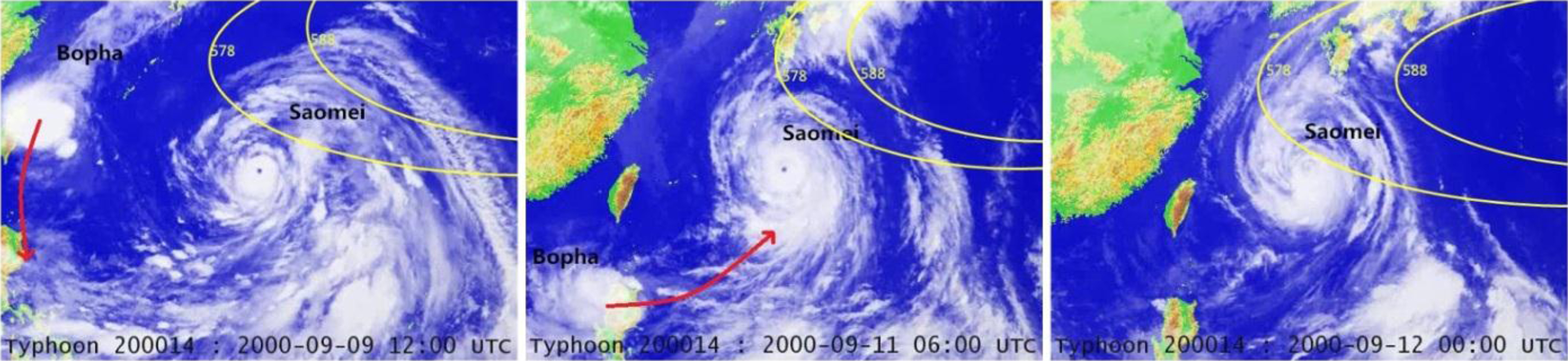
Now, we give an example about fuzzy spatiotemporal objects. As shown in Fig. 1, in 2000, two tropical cyclones, namely Saomei (
The merging process of two fuzzy spatiotemporal objects
Fuzzy spatiotemporal data can be identified in the form of fuzzy spatiotemporal objects, which includes four dimensions: fuzzy spatiotemporal class, fuzzy spatiotemporal attribute, fuzzy spatiotemporal event, and fuzzy spatiotemporal relation. Fuzzy spatiotemporal class.
A set of spatiotemporal objects with the same characteristics and behaviors can be abstractly described as a spatiotemporal class. In addition, the spatiotemporal class can also be defined directly through the form of attribute and method. Due to the following reasons, a spatiotemporal class may be fuzzy: A spatiotemporal class can be abstracted from some fuzzy spatiotemporal objects. The definition of the spatiotemporal class contains fuzzy attributes. Fuzzy spatiotemporal class generates spatiotemporal subclass or superclass through generalization.
A spatiotemporal object is an instance of a spatiotemporal class with a fuzzy degree between [0, 1]. Fuzzy spatiotemporal attribute.
There are three types of fuzzy spatiotemporal attributes: fuzzy spatial attribute, fuzzy temporal attribute, and fuzzy feature attribute. Each attribute corresponds to a range of values. When this range is a fuzzy subset or a set of fuzzy subsets, the corresponding attribute is a fuzzy attribute.
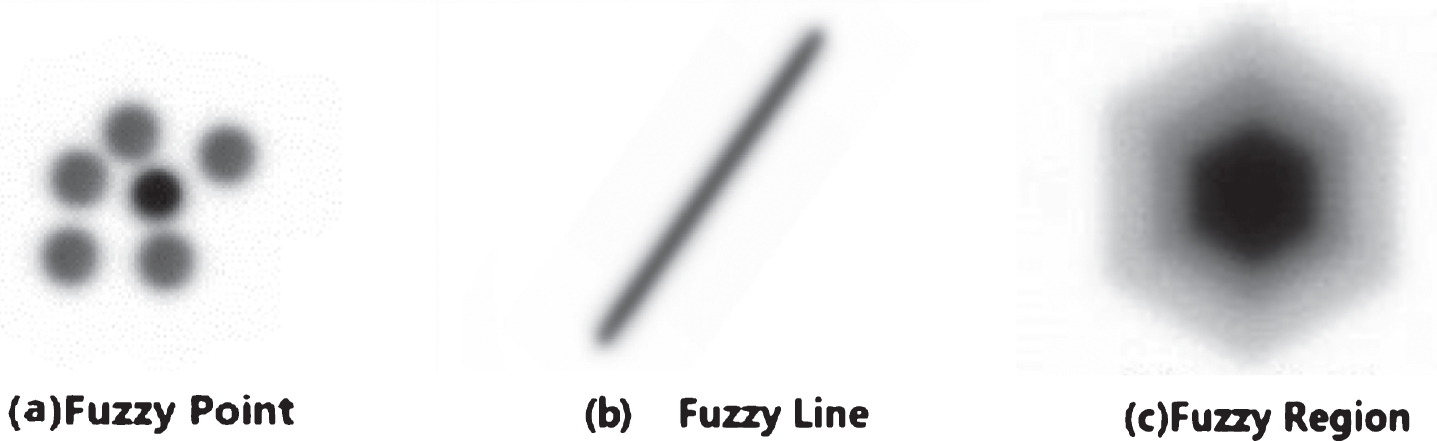
Fuzzy spatial attribute: fuzzy spatial data and fuzzy spatial relation [7, 9]. Fuzzy spatial data is divided into fuzzy point, fuzzy line, and fuzzy region.
For example, a fuzzy point
Fuzzy spatial data.
A fuzzy region is a region whose boundary is fuzzy, as shown in Fig. 2c. We use MBR (Minimum Bounding Rectangle) [16] to represent a fuzzy region.
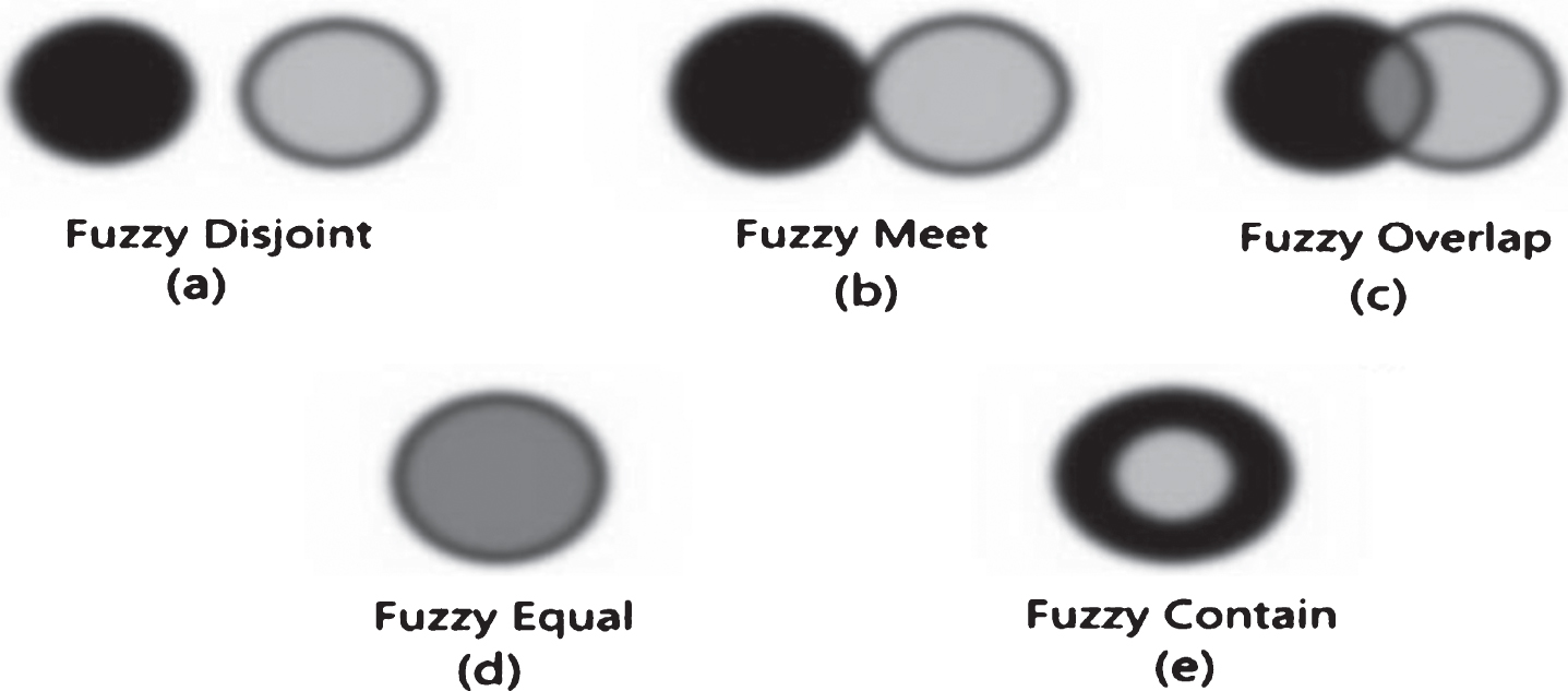
Fuzzy spatial relationship.
Fuzzy temporal attributes: fuzzy time point, fuzzy time interval, and fuzzy temporal relation [8, 19].
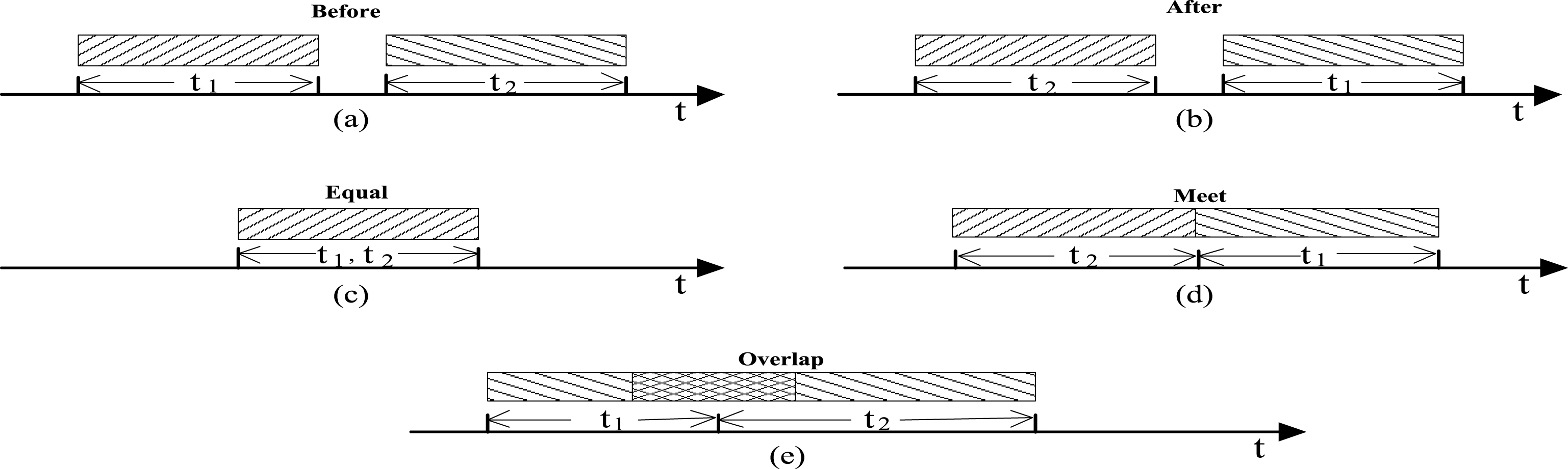
Fuzzy temporal topological relationship.
Fuzzy feature attribute: Feature attributes are a special kind of attributes in spatiotemporal classes, such as size, speed, shape, and material. Each feature attribute has a fuzzy value formally specified by Fuzzy spatiotemporal event
Although the literature [5] provides a formal specification which defines an event as a kind of spatiotemporal model class in object-oriented concepts, it does not take fuzziness into account. In the real world, an event object is often fuzzy and uncertain which causes spatiotemporal events hold to be fuzzy. For instance, in Fig. 1, the spatiotemporal event is fuzzy, because of the ambiguity of the attributes contained in two different classes. At the same time, as shown in Fig. 1, the impact of Subtropical High causes Fujiwhara effect. Fuzzy spatiotemporal classes relation
In the real world, spatiotemporal objects do not exist in isolation, and they usually have complex semantic relations. From the perspective of object modeling, fuzzy spatiotemporal classes as a specific class format, have some semantic relations as follows:
Fuzzy spatiotemporal association: Fuzzy spatiotemporal association is used to represent the relation between fuzzy spatiotemporal classes. As shown in Fig. 1, the relation between subtropical high and tropical cyclone is a fuzzy spatiotemporal association.
Fuzzy spatiotemporal generalization: Fuzzy spatiotemporal generalization is used to represent classification relations between fuzzy spatiotemporal classes, i.e., subclass/superclass relationship. The subclass can inherit the features and behaviors of its super class. For example, Tropical Cyclone includes Super typhoon, Super typhoon, and the typhoon.
Fuzzy spatiotemporal aggregation: Fuzzy spatiotemporal aggregation is used to represent the whole and part relationship between fuzzy spatiotemporal classes. For instance, Tropical Cyclone is composed of TC eye, TC eye-wall, and Spiral rain band, where Tropical cyclone with wind eye, eye-wall and spiral rain band is whole and part relationship.
Please note that the above three kinds of semantic relations exist in fuzzy spatiotemporal class, and the fuzziness of spatiotemporal class directly leads to the ambiguity of spatiotemporal association, generalization and aggregation relations.
The processing of fuzzy spatiotemporal data requires the support of fuzzy spatiotemporal data model. In order to represent fuzzy spatiotemporal data as mentioned above, we present an abstract fuzzy spatiotemporal data model as follows:
For the above fuzzy spatiotemporal abstract data model, we realize fuzzy spatiotemporal object modeling by extending the UML class diagrammodel.
Fuzzy spatiotemporal object modeling base on UML
Representation of fuzzy spatiotemporal class
The fuzziness of fuzzy spatiotemporal class is reflected in two aspects: (i) fuzzy spatiotemporal class concluding fuzzy spatiotemporal attributes (spatial attribute, temporal attribute, and/or feature attribute) and the corresponding fuzzy values; (ii) uncertain membership relation between spatiotemporal object and fuzzy spatiotemporal class. In our paper, we use a dashed rectangle to represent a fuzzy spatiotemporal class. Similar to [23], we also add a special attribute μ ∈ [0, 1] in fuzzy spatiotemporal class. In the following, we give the representation of fuzzy spatiotemporal attribute. Representation of fuzzy spatial attributes
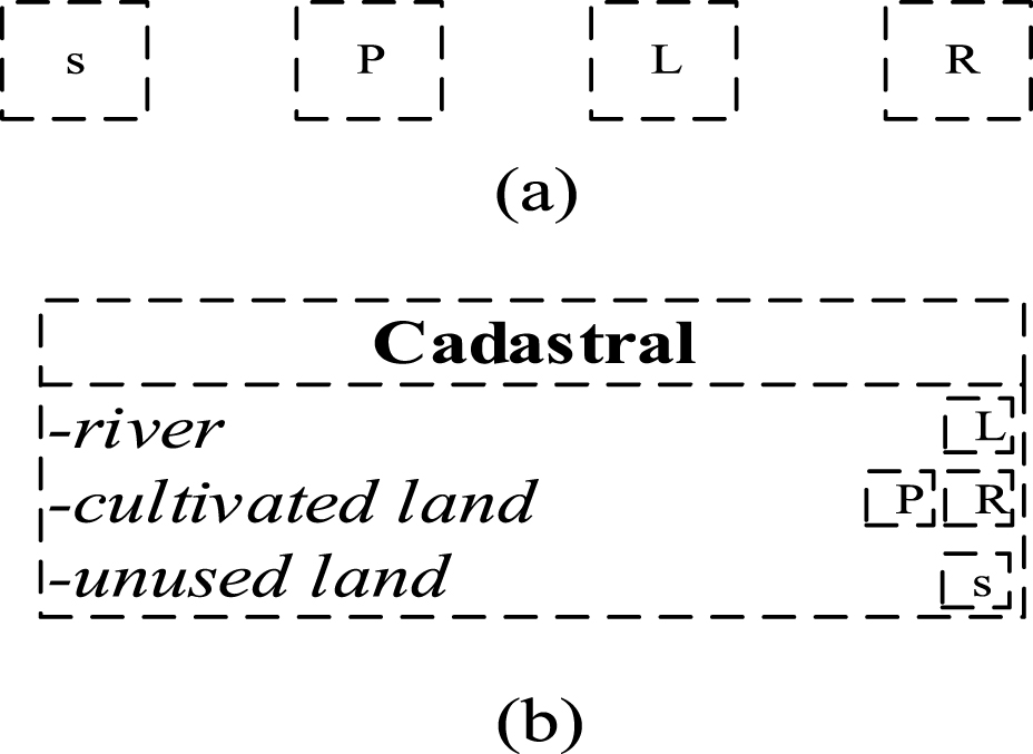
We use a dashed rectangle containing “s”, “P”, “L”, and “R” to represent different fuzzy spatial attributes as shown in Fig. 5(a), where “s” represents the unknown spatial attribute, “P” denotes fuzzy points, “L” denotes fuzzy lines, and “R” denotes fuzzy regions.
As shown in Fig. 5(b), a fuzzy spatiotemporal class called Cadastral includes a river, a land, and unused land. We identify the fuzzy spatial attribute of a river through fuzzy line “L”, identify the fuzzy spatial attribute of a cultivated land through fuzzy point “P” or fuzzy region “R”, and directly identify the unused land through “s”. Representation of fuzzy temporal attribute
Representation of fuzzy spatial attributes.
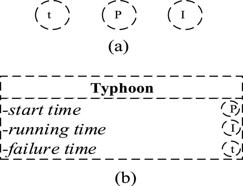
Different fuzzy temporal attributes can be represented by a dashed circle containing “t”, “P”, “l” as shown in Fig. 6(a). In detail, “t” denotes the unknown temporal attribute, “P” denotes fuzzy time point, “l” represents fuzzy time interval.
Representation of fuzzy temporal attributes.
For the spatiotemporal class Typhoon in Fig. 6(b), we use fuzzy time point “P” to identify the fuzzy temporal attribute about a start time of tropical cyclone. Similarly, fuzzy interval “I” is used to identify the fuzzy temporal attribute of running time of tropical cyclone. Since the failure time is not clear, we use fuzzy time “t” to identify this attribute.
Representation of fuzzy feature attributes
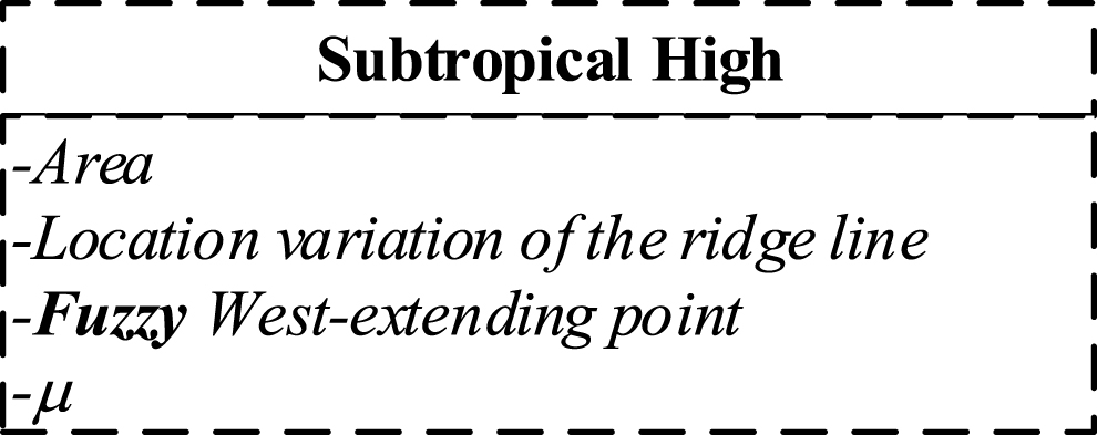
Fuzzy feature attribute is a special attribute. Similar to [23], we also add the keyword “Fuzzy” in front of fuzzy feature attribute to identify it.
There is a fuzzy spatiotemporal class called Subtropical High in Fig. 7. In this class, the value of feature attribute West-extending point is fuzzy, thus we add the key word “Fuzzy” to identify it. In addition, the fuzzy spatiotemporal class Subtropical High contains an additional special attribute μ which denotes the membership between spatiotemporal object and fuzzy spatiotemporalclass.
Representation of fuzzy spatiotemporal class.
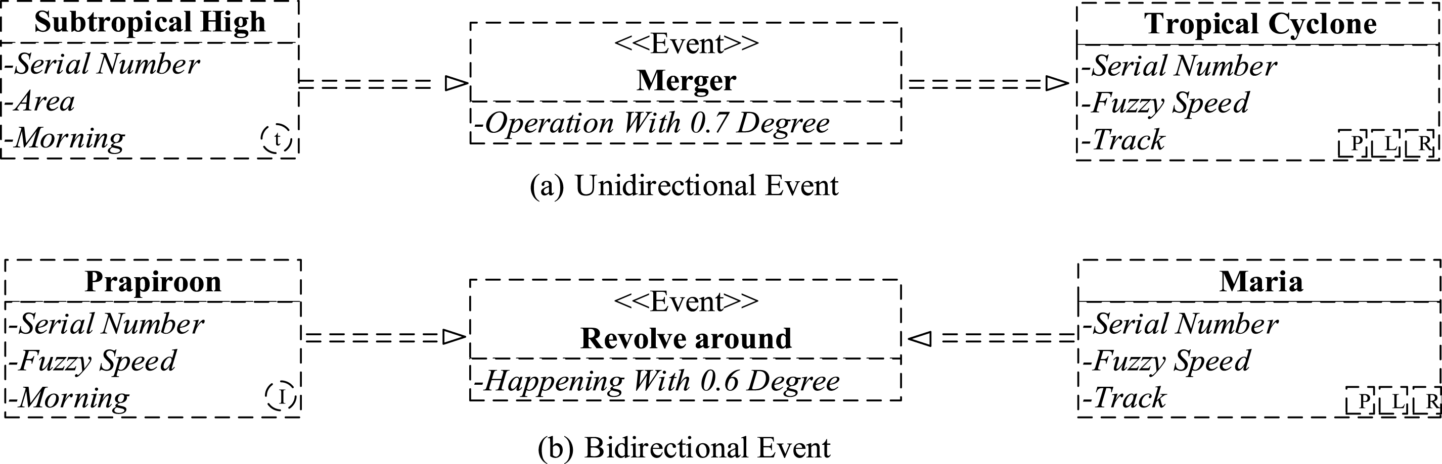
In UML sequence diagram and state diagram, one can represent a specific event, but the event belongs to an object level. In other words, the events in UML state diagram represent operations between concrete objects. However, UML class diagram lacks the representation and description of an event [5]. Thus, in order to represent an event of fuzzy spatiotemporal class (e.g., an event on Subtropical high to a tropical cyclone), it is necessary to introduce a new component into UML class diagram. In this section, we extend UML class diagram by adding a fuzzy spatiotemporal event.
Figure 8(a) represents a one-way merger event Merge, i.e., under the influence of Subtropical High-pressure, Tropical Cyclone merge event holds. Subtropical High contains fuzzy spatiotemporal attribute Morning identified by “t”. At the same time, it contains a fuzzy spatiotemporal attribute Serial Number. Tropical Cyclone contains a fuzzy spatiotemporal attribute Track. We use “P”, “L”, and “R” to identify this attribute. In Fig. 8(a), Merge represents a fuzzy spatiotemporal event, and the direction of the arrows indicates the order in which the events occur and the driving relationship. The “Operation with 0.7 Degree” means that Tropical Cyclone had a probability of 0.7 for Merge event under the influence of Subtropical High.
Fuzzy spatiotemporal event model.
Figure 8(b) denotes a two-way event called Revolve around. The tropical cyclone Parpiroon contains a fuzzy time interval attribute Morning identified by the letter “I”. At the same time, it includes a fuzzy feature attribute called Serial number and Fuzzy speed. The class Maria contains a fuzzy spatial attribute Track using the representation of the letter “P”, “L”, and “R”.
The class Revolve around is an event hold between the Parpiroon and Maria. “Happening with 0.6 Degree” means that the membership degree of event Revolve around hold is 0.6.
Fuzzy spatiotemporal relations represent semantic relations between fuzzy spatiotemporal classes. In the following, we give a UML representation of fuzzy spatiotemporal relationships in the forms of fuzzy spatiotemporal association, fuzzy spatiotemporal generalization, and fuzzy spatiotemporal aggregation. Representation of fuzzy spatiotemporal association
The position or state of fuzzy spatiotemporal objects can change over time. There are some relationships between different fuzzy spatiotemporal objects. Similarly, there are some spatiotemporal association relations between spatiotemporal classes in UML class diagram. When spatiotemporal classes are fuzzy, the corresponding association relations between classes may also be fuzzy.
Fuzzy spatiotemporal association describes a relationship between instances. The association is a more general relationship than generalization and aggregation relationships. Please note that we use two-headed arrows to represent instances with membership relationships.
In UML class diagram shown in Fig. 9, we use a dotted line to represent a fuzzy spatiotemporal association, in which fuzzy association called “influence” between Subtropical High and Tropical may exist. Representation of fuzzy spatiotemporal generalization

Fuzzy spatiotemporal association in UML.
Spatiotemporal generalization represents a spatiotemporal class that is a set of classes with a more general description of a spatiotemporal class, i.e., superclass and subclass. If a spatiotemporal subclass or superclass is fuzzy, then the generalization relationship between superclass and subclass is also fuzzy.
As shown in Fig. 10, we use a dotted line triangle to represent a fuzzy spatiotemporal generalization relationship in UML class diagrams. In this UML, Super typhoon is a fuzzy spatiotemporal class with a fuzzy temporal attribute and a fuzzy feature attribute. Also, the Typhoon is a fuzzy spatiotemporal class, but it contains a fuzzy spatial attribute and a fuzzy feature attribute. Severe typhoon is a crisp class. The three classes are generalized with Tropical Cyclone. Representation of fuzzy spatiotemporal aggregation

Fuzzy spatiotemporal generalization in UML.
Fuzzy spatiotemporal generalization can capture a whole-part relationship between a fuzzy spatiotemporal class and a set of fuzzy spatiotemporal classes.
As shown in Fig. 11, in UML class diagrams, we use dotted line diamond to represent fuzzy spatiotemporal aggregation, where Tropical Cyclone and TC eye, TC eyewall, Spiral rain band are a whole-part relationship.
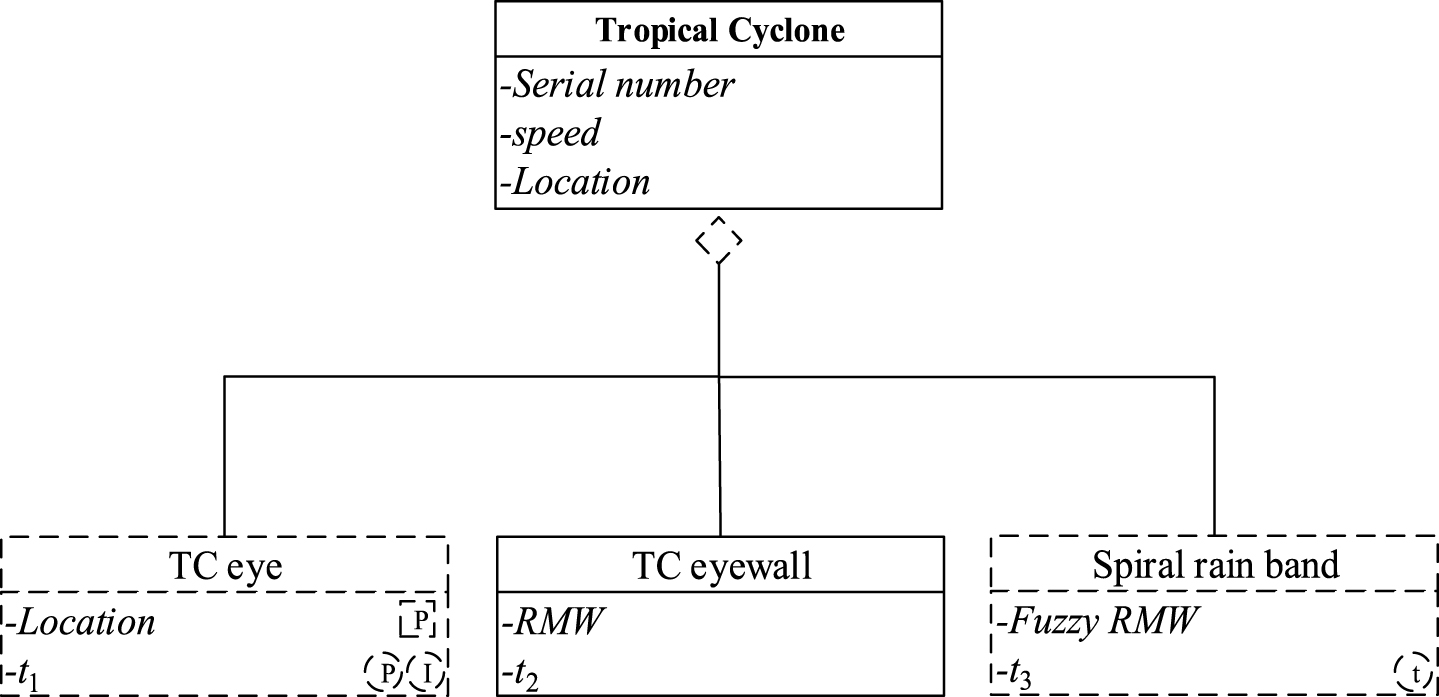
Fuzzy spatiotemporal aggregation in UML.
Combining Fig. 1 with the collected data [6] and [3, 11], we obtain fuzzy spatiotemporal merging process of the tropical cyclones Saomei and Bopha shown in Fig. 12.
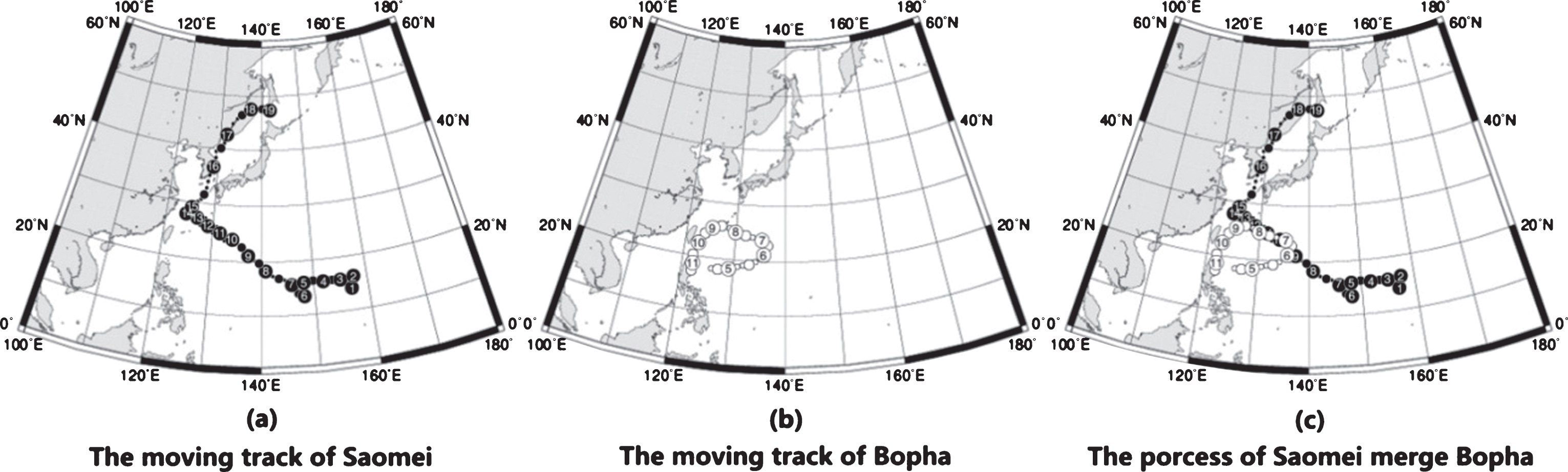
Fuzzy spatiotemporal phenomenon of merging.
Figure 12(a) shows a moving track of tropical cyclone Saomei. As can be seen from Fig. 12(a), the tropical cyclone Saomei occurred in the evening on August 31, 2000, and disappeared in the early morning on September 19, 2000. The time points are fuzzy and the positions are imprecise. Fig. 12(b) shows a moving track of tropical cyclone Bopha. In this figure, tropical cyclone Bopha occurred in the early morning on September 4, 2000, and disappeared in the noon on September 11, 2000. Fig. 12(c) shows a merging process of the two tropical cyclones. The tropical cyclone Bopha merged with Saomei completely on September 11, 2000.
The spatiotemporal phenomenon in Fig. 12 includes (i) two spatiotemporal objects, namely, tropical cyclones Saomei(OSaomei) and Bopha(OBopha); and (ii) three spatiotemporal events, namely, moving event of Saomei and BophaEMove = (OSaomei, OBopha, t1), merging event of Saomei and BophaEMerge = (OSaomei, OBopha, t2), and event of enhanced SaomeiEIncrease = (OSaomei′, t3). Specifically, a Fujiwhara process is constructed by the three events. In those events, every spatiotemporal object related to events includes many attributes, such as spatial positions, central wind power, central pressure, and speed. Those attribute values can be fuzzy (such as low pressure and high speed).
Thus, we can obtain three fuzzy spatiotemporal objects with fuzzy attribute values called
Using fuzzy UML spatiotemporal objects modeling method proposed in Section 3, we can construct a fuzzy UML spatiotemporal data model as shown in Fig. 13. The model includes three fuzzy events, and every fuzzy event includes serial fuzzy spatiotemporal classes. The fuzzy UML spatiotemporal data model shown in Fig. 13 can describe the entire process of Fujiwhara effect occurring in Fig. 1.

Fuzzy UML spatiotemporal data model.
In Fig. 13, fuzzy event class Move is a superclass, which is used to represent fuzzy spatiotemporal move event. It includes two fuzzy subclasses Subtropical High and Tropical Cyclone. Class Subtropical High includes fuzzy spatial attribute Area. We use a dashed square with letter “R” to represent the fact that the range of class Subtropical High can be a region. Fuzzy west-extending point is a fuzzy feature attribute. The coordinates of the west extension point of the class Subtropical High are represented by the word “Fuzzy”. Class Tropical Cyclone includes fuzzy spatial attribute Track. We use a dashed square with letter “P” to represent the fact that the track of Class Tropical Cyclone can be a point. Fuzzy temporal attribute Noon identified by a dashed circle with letter “P” is used to represent the time point of class Tropical Cyclone.
Both Fuzzy class Subtropical High and Tropical Cyclone have an additional attribute μ to describe a membership degree of a spatiotemporal object belonging to the corresponding class. Fuzzy class Move represents a moving event, which means that both Subtropical High and Tropical Cyclone move during a fuzzy time interval, where “Operation with 0.9 Degree” represents that the two fuzzy spatiotemporal objects are moving at the same time with a probability of 0.9.
Combined with Fig. 1 and direction arrow of event classes, we can know that Subtropical High Saomei and Tropical Cyclone Bopha are moving at time point t1.
Then, fuzzy event class Merge represents one-way merge event, which is related to two fuzzy classes Subtropical High and Tropical Cyclone. The Class Subtropical High includes fuzzy feature attribute “Intensity for grade 3 with 0.7 degree”, which means that fuzzy degree of grade 3 is 0.7.
The Class Tropical Cyclone includes a fuzzy temporal attribute called Morning. We use a dashed circle with letter “I” to represent the time interval. Fuzzy class Merge represents a merge event and the direction of hollow triangular arrow represents an order of event and driving relationship. Please note that the merge event illustrates a fact that Subtropical High can affect Tropical Cyclone. The attribute “Operation with 0.5 Degree” means that the possibility of merge is 0.5 under the influence of Subtropical High.
As mentioned in Fig. 1, the possibility of merge event between Saomei and Bopha is 0.5 under the influence of Subtropical High.
Finally, fuzzy event class Increase represents increasing event of tropical cyclone. The Class Tropical Cyclone includes fuzzy spatial attribute Track. A dashed circle with letter “P” is used to represent a fuzzy point. Similarly, we use a dashed circle with letter “L” to represent a fuzzy line.
Fuzzy Pressure denotes that the pressure is fuzzy. “Wind speed for grade 11 With 0.5 degree” represents that the fuzzy degree of wind speed for grade 11 is 0.5. According to Fig. 1, fuzzy event class Increase represents the increasing event after tropical cyclone Saomei and tropical cyclone Bopha merged. “Operation with 0.7 Degree” means that the possibility of Saomei increasing after merging event is 0.7.
Up to now, we can see that the fuzzy spatiotemporal data model in Fig. 13 can illustrate Fujiwhara effect as shown in Figs. 1 and 12 under the influence of subtropical high.
In this paper, we discuss the semantics of fuzzy spatiotemporal data based on spatiotemporal events, including fuzzy spatiotemporal classes, fuzzyspatiotemporal attributes, fuzzy spatiotemporal events, and fuzzy spatiotemporal relationships. On this basis, we propose a fuzzy UML spatiotemporal data model based on events by extending UML data model. This model takes into account the uncertainty of the information and enhances the description of the event process to lay a foundation for the management fuzzy spatiotemporal data.
In the future, we will make a further extension of fuzzy UML spatiotemporal data model based on fuzzy events to meet the diverse applications of spatiotemporal applications.
Footnotes
Acknowledgments
The work is supported by Natural Science Foundation of Ningxia Province (No. NZ15250) and Natural Science Foundation of Liaoning Province (No. 2015020048).