
Abstract
The first significant heavy mineral sands discovery within the Murray Basin, Australia, was made in 1982 at the WIM150 deposit near Horsham, Victoria. This fine-grained (20–75 µm) deposit formed in an offshore environment (WIM-style deposit). The heavy minerals (HM) are within the Loxton Sand, which is prospective throughout the Murray Basin for HM in both strandlines and WIM-style deposits. At WIM150, HM are concentrated in a horizon that extends for 10 km north–south and 12 km east–west and has a thickness that ranges from 2 to 22 m with an average of 11.2 m. Measured, Indicated and Inferred Mineral Resources totalling 1650 million tonnes at 3.7% total HM were estimated in 2013. Test work has demonstrated that the resource can be processed to +20 µm and that the 20–38 µm size fraction contains significant concentrations of HM (14.8% of the HM within the 20–75 µm size fraction). Test work also demonstrated that the HM from the 20 to 38 µm size fraction contain more than 40% ZrO2 and CeO2 (assumed to be contained in zircon and monazite, respectively). The project is estimated to have an Ore Reserve mine life of 55 years and is the most advanced, in terms of development, of the Murray Basin WIM-style deposits. A definitive feasibility study for the WIM150 deposit was completed in mid-2013.
Introduction
The Murray Basin is one of the major mineral sand production areas in Australia and the first significant mineral sand discovery was made in the early 1980s by Conzinc Riotinto Australia Exploration Pty Ltd (CRA) at the WIM150 deposit. During the next 4 years CRA identified an additional five deposits of fine-grained (38–75 µm) heavy mineral sands within the Wimmera district of the Murray Basin. These fine-grained deposits, which are referred to as WIM-style deposits, formed in an offshore environment, possibly with extensive reworking of older basin sediments by wave action.
The WIM150 heavy minerals (HM) deposit lies within the south-eastern margin of the Murray Basin, south-eastern Australia (Fig. 1), approximately 20 km south-east of Horsham and 280 km north-west of Melbourne (Fig. 2). CRA undertook extensive exploration and development studies of the WIM150 deposit (using the 38–75 µm fraction) but eventually relinquished this project in the late 1990s as the project was judged to be uneconomic in the foreseeable future. Mining elsewhere in the Murray Basin commenced in 2000, however, to date this has focussed on the coarser-grained (45–1 mm) strandline deposits.
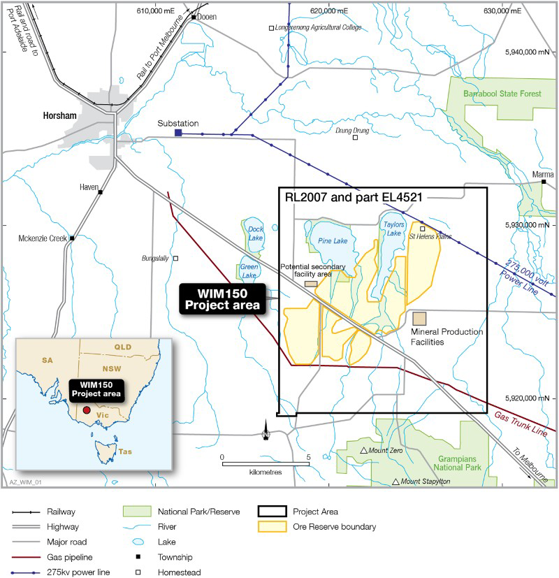
Location of WIM150 project in southern Australia and regional infrastructure WIM150 project location plan illustrating tenement area and outline of Ore Reserves, with proposed locations of production facilities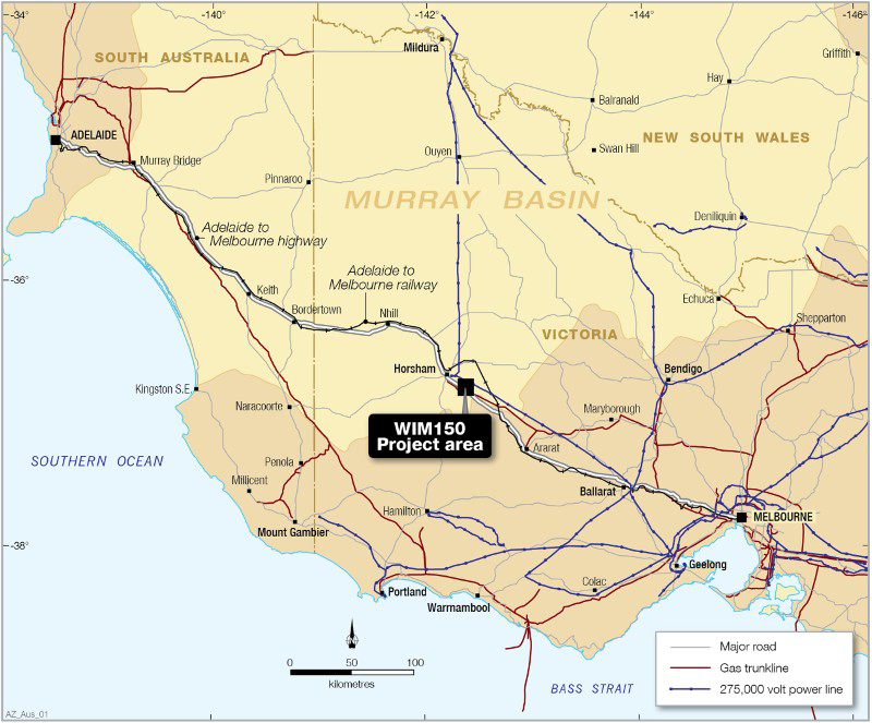
Recent test work at WIM150 has demonstrated that the resource can be processed to +20 µm and that the fine-grained material (20–38 µm) contains more than 40% ZrO2 and CeO2 (assumed to be contained in zircon and monazite, respectively). This enhanced the project economics and the WIM150 project is the first of the WIM-style deposits to progress to a definitive feasibility stage. In addition, the identification of monazite and xenotime in the fine-grained fraction (20–38 µm) demonstrates significant potential for future rare earth element production from the Murray Basin (Mudd and Jowitt 2016).
Geology
Regional geology
The Murray Basin succession is divided into three Palaeocene to Pliocene sedimentary sequences, overlain by a thin cover of Quaternary sediments. It covers an area of approximately 300 000 km2 and comprises Cenozoic marine and terrestrial sediments that were deposited in a low relief, saucer-shaped intracratonic basin. The sea inundated the Murray Basin several times during the Cenozoic, and the last marine transgression was during the Pliocene. These transgressions have been correlated with global sea level rises (Brown and Stephenson 1991).
The Murray Basin is bounded to the south-west by basement rocks of the Mount Lofty and southern Flinders Ranges and to the north by the Archaean Broken Hill Block and the Late Palaeozoic rocks of the Darling Basin. Sedimentary, metamorphic and igneous rocks of the Lachlan Fold Belt and the Victorian Highlands form the eastern and south-eastern boundaries (Brown and Stephenson 1991).
Sedimentation began in the Murray Basin in the Palaeocene with the deposition of a non-marine-dominated succession, the Renmark Group. The second phase (Oligocene–Middle Miocene) consisted mainly of marine sedimentary deposition, comprising clays (Geera Clay) and limestone of the Murray Group. The third episode (Upper Miocene–Middle Pliocene) of deposition consisted of a marine transgression, which began with the deposition of a succession of plastic green, grey and brown calcareous clays and silts, with minor sand named the Bookpurnong Beds (Brown and Stephenson 1991). The Bookpurnong Beds are conformably overlain by a succession of marginal marine sands referred to by Brown and Stephenson (1991) as the Loxton Sand and the Parilla Sand, or the Loxton-Parilla Sand. These two units were consolidated as the Loxton Sand in 2011 (Robson and Webb 2011). Marine transgression is recorded by north–north-west trending shoreline ridges identified in the Loxton Sand. The Loxton Sand contains heavy mineral (HM) deposits within coarse-grained (45–1 mm) strandlines and fine-grained (20–75 µm) offshore sediments throughout the Murray Basin.
HM grains entered the Murray Basin through a number of river systems which transported rutile- and zircon-bearing sediments derived from the weathering and erosion of the Palaeozoic granites of the Lachlan Fold Belt and sandstones of the Mesozoic basins. HM sands would also have been formed by erosion of Palaeozoic to early pre-Quaternary Cenozoic mafic volcanics by river systems draining the Great Dividing Range (Farrell et al. 2001).
The Loxton Sand is disconformably overlain by non-marine late Pliocene to Recent sediments. The disconformity at the top of the Loxton Sand is commonly marked by a ferruginous, locally siliceous, weathering profile known as the Karoonda Surface. In the central sector of the basin, the overlying sediments are fluvio-lacustrine clays, the Blanchetown Clay (Brown and Stephenson 1991). Where the Blanchetown Clay is absent, the Loxton Sand is disconformably overlain by a thin succession of unconsolidated red-brown siliceous silty sand, sandy clay and clay-pellet aggregates, which form extensive east–west oriented dunes of the Woorinen Formation. This unit varies in thickness from absent to approximately 30 m in locally developed dune fields.
The uppermost unit was formed by late-stage, crescent-shaped dunes known as the Lowan Sands. In the eastern and south-eastern parts of the Murray Basin, the Blanchetown Clay to Lowan Sand sequences are replaced by the fluvial sediments of the Shepparton Formation. This is a sequence of clays, sandy clays and medium- to coarse-grained sands associated with floodplain deposition from the major river systems (Brown and Stephenson 1986).
WIM150 deposit geology
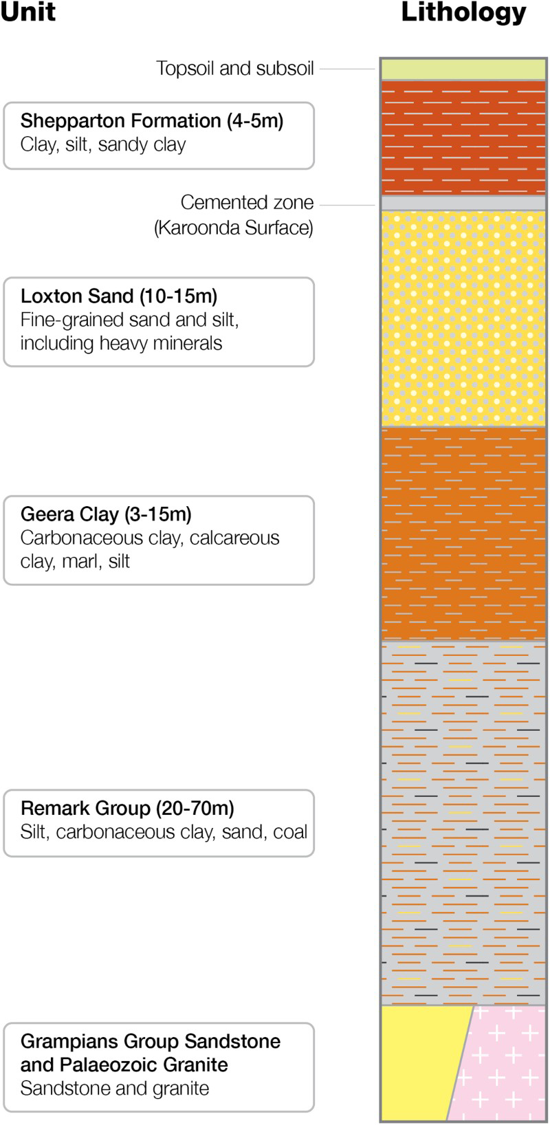
The WIM150 HM mineralisation is hosted by the Loxton Sand, which is overlain by Shepparton Formation clays. The Geera Clay forms the base to the mineralisation through much of the deposit, although in the south-west the mineralisation overlies Silurian-Devonian Grampians Group sandstone.
The generalised stratigraphic sequence of the Murray Basin at the WIM150 deposit (Fig. 3) is
Renmark Group (Eocene) – marine and fluvial silts, sands, clays and minor brown coal that can be divided into two units
Warina Sand: lower unit of uniform medium- to coarse-grained sand. Olney Formation: upper unit comprising silts, clays and sand and minor carbonaceous clay and brown coal. Geera Clay (Late Oligocene to Middle Miocene) – a plastic to friable black, grey and dark-green clay, typically 3–15 m thick. It is interpreted to have formed in a shallow-water, marginal marine, lagoonal or tidal flat environment and is often pyritic. Unconformity – after the Geera Clay was deposited, the sea retreated. The erosional period that followed the deposition of the Geera Clay led to the development of a horizontal surface and a lateritic profile. The unconformity between the Geera Clay and the Loxton Sand is locally marked by an increased level of ferruginisation and silicification of the Geera Clay and by the presence of ferruginous gravel. Loxton Sand (Late Miocene to Pliocene) – dominantly marine sediments. A series of prograding shorelines produced an upward-coarsening sequence of clay and very fine to coarse-grained marine sands, which was followed by an upward-fining sequence of beach sediments and minor aeolian dune sands. The Loxton Sand consists of marine sands representing a range of environments including deep-water (offshore), near-shore, tidal, beach and dunal settings. This unit hosts known HM deposits throughout the Murray Basin. Karoonda surface (unconformity) – an old land surface, represented by a lateritic profile marked by ferruginisation and silicification of the top of the Loxton Sand, and up to 2 m thick. Shepparton Formation (Late Pliocene to Pleistocene) – deposits of sheet-like, medium- to high-plasticity clay, silt and sand clays, and shoestring sand deposits left behind as the sea level declined in the Late Pliocene. These sediments are 4–5 m thick across the majority of WIM150 project area. Quaternary sediments – rivers have locally eroded the Loxton Sand, Geera Clay and Renmark Group in places and deposited Quaternary fluvial sediments. Fluvial deposits of the modern Mackenzie and Wimmera rivers systems occur in the area and truncate the Loxton Sand (Williams 1990). Stratigraphic section of the WIM150 deposit where HM mineralisation is hosted by the Loxton Sand (illustrated in Fig. 3)
WIM150 deposit characteristics
The major features that distinguish the WIM150 deposit were defined by Williams (1990) and are
broad lobate plan geometry; lateral continuity of individual HM lenses; continuity of grade over a large area (almost 40 km2); uniformity of the HM assemblage; fine grain-size of HM and host sands; undulating to hummocky cross-stratified HM concentrations.
These features suggest offshore deposition and distinguish the WIM150 deposit from deposits formed in beach (strandline) situations.
The WIM150 mineralisation forms a flat sheet that extends for 10 km north–south by 12 km east–west, with a thickness that ranges from 2 to 22 m with an average of 11.2 m. The overlying Shepparton Formation has an average thickness of 6.8 m but ranges from 1 to 13 m. Interpretation of the total HM content of the mineralised horizon indicates that the WIM150 deposit is not a uniform sheet but is a series of north-easterly trending mineralised zones with lower-grade mineralisation between. The mineralised horizon is made up of very thin (less than 1 mm thick) layers of very high total HM material interleaved with barren material (Fig. 4).
Drill core from the Loxton Sand illustrating numerous very thin (less than 1 mm thick) layers of high total HM concentrations (darker layers) interleaved with barren material (light layers)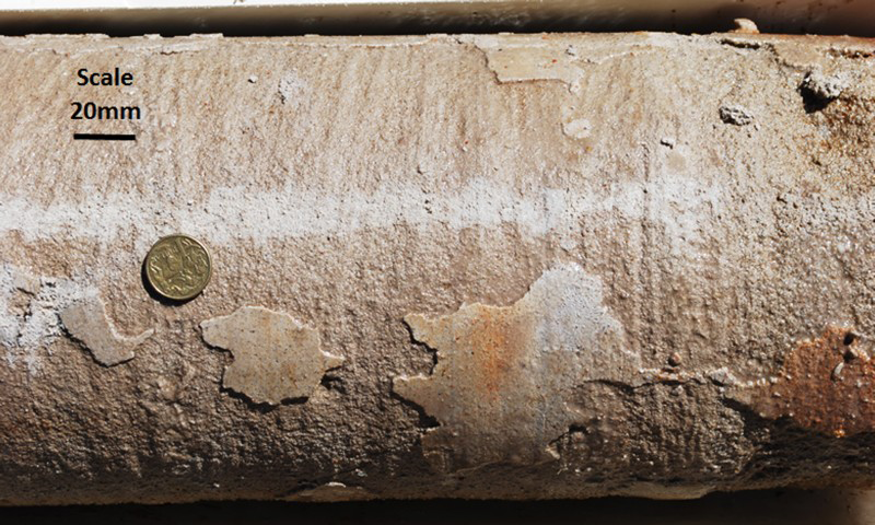
Post-depositional processes have created discontinuous zones of variable induration within the deposit. About 6% of oversized (+1 mm) material is estimated to be contained within the WIM150 Mineral Resource. Oversized material within the mineralisation comes from three main sources
Scour channels which generally run at right angles to the palaeo-coastline and are filled with fine to medium gravels that have been washed down from the beaches. Thin bands of iron-cemented silt and fine sand caused by the removal of iron from the HM suite (particularly from the ilmenite to form leucoxene) and the re-deposition of the iron as ferruginous cement. The ferruginous bands are generally less than 30 mm thick, are highly erratic in their distribution and are more frequent in the areas with higher total HM concentrations. The lateritic gravel associated with the top of the Geera Clay and the Karoonda surface. This generally contains very little valuable HM and is not within the interpreted mineralised horizon used for mineral resource estimation.
Exploration history
Exploration drilling (1979–2001)
The WIM150 deposit is one of a series of HM deposits discovered in the Murray Basin in the 1980s by CRA. CRA first targeted the southern margin of the Murray Basin to explore for brown coal by acquiring airborne magnetic and radiometric data, and conducting a regional drilling programme to test the basin stratigraphy. Numerous brown coal seams were intersected and extensive, but uneconomic, coal deposits were discovered. The depth of the coal (150–200 m) and the thin coal seam thickness resulted in the exploration focus shifting from coal to HM.
Exploration by CRA from 1985 to 1990 for HM in the Murray Basin is documented by Harvey and Williams (1985), Williams (1986), Williams and Brewster (1987), Allnutt et al. (1988), Smart and Williams (1988) and Smart and Allnutt (1990). Gamma logs were run in a number of exploration drill holes near Horsham in 1982 as part of the coal exploration programme. These recorded elevated radiation levels from the Loxton Sand, which subsequently proved to be associated with accumulations of HM. Follow-up drilling indicated that potentially large amounts of near-surface HM were widespread in the Horsham area but were predominantly fine-grained (grain-size range of 3875 µm).
CRA advanced the WIM150 project through a number of drilling, bulk-sampling, engineering and metallurgical-testing programmes to a pre-feasibility stage by the late 1990s. This included the construction of a pilot plant, excavation of costeans and completion of an environment effects statement to draft stage. CRA relinquished the project tenements in 1999 as the project was judged to be uneconomic in the foreseeable future. The economic evaluation was based on the recovery of the titanium minerals only and included high energy and mining costs.
In 2000, the Victorian Government made CRA's database available to stimulate exploration and released the areas identified by CRA as having potential for HM concentrations for competitive tender. The area containing the WIM150 deposit was awarded to Austpac who held tenure over EL4521 from 2001 to 2013. In 2004, Australian Zircon commenced exploration activities at the WIM150 project under a farm-in agreement with Austpac and later Orient Zirconic Resources (Australia) Pty Ltd.
Project development drilling (2006–14)
During 2006, Australian Zircon completed a programme of 27 aircore drill holes to twin the CRA drill holes. The drilling results confirmed the overall reliability of the CRA data in the test area in terms of total HM content but suggested that the CRA drilling results might understate the total HM grade.
During 2012/13, drilling included 140 holes for resource definition and 12 holes to sterilise the proposed plant and infrastructure area. Test work (discussed below) indicated that that the resource could be processed to +20 µm and 65 samples were analysed to define the valuable HM components within the total HM from the 2075 µm fraction by scanning electron microscope. The CRA data included 479 mineral assemblage data determined from optical mineralogy of the total HM from the 38 to 75 µm fraction. Quantile–quantile plots were used to determine the population distributions defined by the CRA 38–75 µm mineralogy data and the data from the 20 to 75 µm fraction for each valuable HM component. Multivariate regression formulae were developed to calibrate the CRA 38–75 µm mineral assemblage data to the 20–75 µm data.
In early 2013, a large-diameter (200 mm diameter triple-tube barrel) drilling programme of five holes was completed to obtain 58 samples for bulk density test work. Bulk density measurements ranged from 1.5 to 2.46 t m−3, with an average of 1.8 t m−3. A dry density of 1.8 t m−3 was used for volume-to-tonnage conversion for the Mineral Resource estimate.
Processing testwork (2006–13)
In 2007, samples from an aircore drilling programme were used as a bulk sample to assess the treatability of the ore. The bulk sample was processed using standard mineral sands technology and produced initial zircon, leucoxene, primary ilmenite and secondary ilmenite products. HM were concentrated in spirals, with valuable minerals extracted using gravity, magnetic and electrostatic separation techniques and it was concluded that commercially acceptable recoveries of mineral products could be achieved.
In 2011, test work of an 11 t run-of-mine sample and a 2-t low-grade sample indicated that the resource could be processed to +20 µm. It also showed that 14.8% of the total HM was found to be contained within the 20–38 µm size fraction and that the total HM from this fraction contained more than 40% ZrO2 and CeO2 (assumed to be contained in zircon and monazite, respectively).
For the definitive feasibility study process testwork was undertaken to establish a simplified process flowsheet in order to optimise product recovery. The process flow uses existing technology, much of which has advanced since the WIM-style deposits were discovered. A zircon upgrade process was also successfully trialled which reduces uranium and thorium content, together with that of other impurities, to obtain a high-purity zircon flour. The bulk sample programme and subsequent test work resulted in proven process flows producing economically viable products at market specifications.
Mineral resource
A Mineral Resource estimate for the WIM150 deposit was developed in 2013 which incorporated data from the CRA and Australian Zircon drilling programmes and formed the basis of the WIM150 definitive feasibility study.
Geology and assay data from 1000 drill holes (for a total of 19 919 m) were used to interpret a mineralised horizon that was defined above a nominal cut-off grade of 1% total HM. Total HM analysis from the CRA and the Australian Zircon 2006/07 and 2011 drilling was from the 38 to 75 µm particle size fraction. In 2012, 134 samples from the 2011 drilling programme were rescreened at 20 μm and the results indicated that 14.2% of the total HM is contained within the 20–38 μm fraction. These sample data were used to determine the percentage of total HM within the 20–75 µm particle size fraction using the percentage of total HM measured in the 38–75 µm particle size fraction (Fig. 5) and both the CRA and Australian Zircon data were used for resource estimation. The 20–75 µm data and the CRA 38–75 µm mineral assemblage data (calibrated with the 20–75 µm data) were used to estimate the percentage of zircon, monazite, xenotime, rutile, ilmenite and leucoxene contained within the total HM from the 20 to 75 µm fraction.
Scatter plot and regression formula used to derive estimates of the % total HM within the 75–20 μm fraction from the % total HM within the 75–38 μm fraction, for samples where the % total HM from the 75–20 μm fraction was not available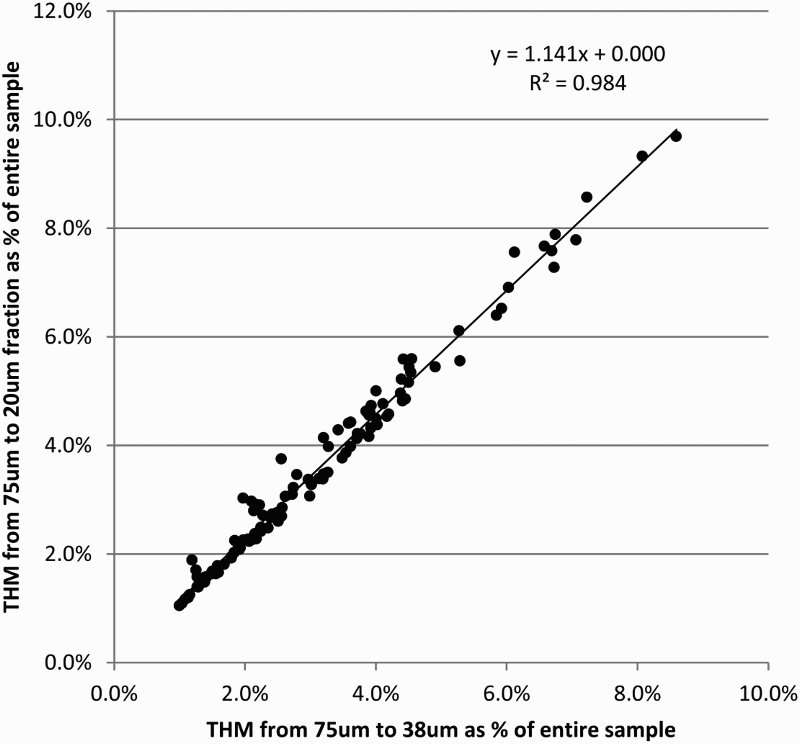
The Mineral Resource model for the WIM150 deposit was constructed using a parent block size of 200 m east by 200 m north on 2 m benches, and the parent blocks were allowed to sub-cell down to 50 m east by 50 m north by 0.5 m elevation to more accurately represent the domain geometries and volumes. Block grades were estimated using ordinary kriging techniques with appropriate top-cuts applied to the data.
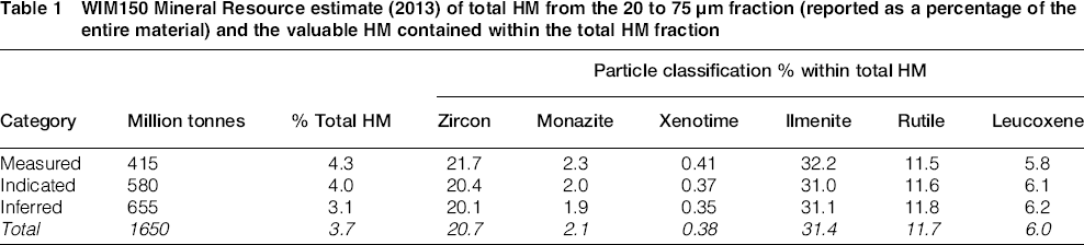
WIM150 Mineral Resource estimate (2013) of total HM from the 20 to 75 µm fraction (reported as a percentage of the entire material) and the valuable HM contained within the total HM fraction
Conclusions
The WIM150 deposit is one of a series of HM deposits discovered in the Murray Basin in the 1980s by CRA and Australian Zircon built on the exploration and development work originally undertaken by CRA to form the basis of the WIM150 Mineral Sands Project definitive feasibility study. Data from drilling by CRA and Australian Zircon at the WIM150 project were used to estimate Measured, Indicated and Inferred Mineral Resources totalling 1650 million tonnes at 3.7% total HM. HM will be extracted to produce HM concentrate, zircon, rare earth minerals and titanium minerals. Bulk sample test work indicated that the resource can be processed to +20 µm and that the total HM from 20 to 38 µm size fraction contains more than 40% ZrO2 and CeO2 (assumed to be contained in zircon and monazite, respectively). The project is the most advanced in terms of development of the deposits formed in an offshore environment and is estimated to have an Ore Reserve mine life of 55 years.
Footnotes
Acknowledgements
The authors wish to thank Australian Zircon NL for their permission to publish this paper. Work by external consultants undertaken on behalf of Australian Zircon NL is gratefully acknowledged.