
Abstract
Urban encounters often involve interactions with people we do not personally know and has been linked to positive mental, emotional, and physical well-being. While previous studies have focused on the associations between urban encounters, social networks, and mobility patterns, this study examines their dynamics through the lens of daily routines, activity spaces, and third places. Drawing on mobile cellular signaling data from Qingdao, China, the research analyzes the activities of more than 600,000 residents over a five-day period, offering unique insights into non-commute behaviors and spatial patterns. The findings indicate that third places—especially retail services and mixed-use residential and industrial areas—function as key venues for fostering social encounters. The built environment emerges as instrumental in facilitating these interactions, with factors such as proximity and amenity diversity playing crucial roles. Residents who occupied larger activity spaces and had greater access to third places experienced more frequent encounters with familiar strangers. These results underscore the value of thoughtful urban design in promoting social cohesion and community well-being. By integrating advanced spatial analysis with the “15-minute neighborhood” concept, this research provides actionable guidance for urban planners seeking to enhance passive social connectivity. The study broadens our understanding of urban social life beyond traditional commute-focused perspectives, highlighting the importance of everyday spaces in fostering meaningful, if subtle, forms of social engagement.
Introduction
Cities are shaped by encounters; urban spaces emerge from a multitude of interactions among individuals (Massey, 2005). In urban environments, these encounters often involve interactions with strangers, highlighting the inherent anonymity of city life (Ahmed, 2000; Amin, 2013). However, such encounters provide opportunities for social interaction (De Stefani and Mondada, 2018; Wilson and Darling, 2016), which have positive effects on mental, emotional, and physical well-being (House et al., 1988; Krach et al., 2010). These interactions frequently occur as part of individuals’ daily routines—the habitual sequences of activities that structure their day-to-day lives (Dirksmeier and Helbrecht, 2015).
The “familiar stranger” emerges from this intersection, describing individuals who regularly observe each other in shared public spaces without engaging in direct communication (Milgram, 1977). In dense, socially diverse urban settings, daily routines often lead to repeated, non-interactive encounters with the same individuals (Sun et al., 2013). For example, commuters taking the same train each morning may recognize fellow passengers without ever exchanging greetings. These familiar strangers subtly contribute to a sense of continuity and shared experience (Paulos and Goodman, 2004), fostering subconscious community and security even without personal ties (Zahnow and Corcoran, 2025).
The built environment shapes individuals’ daily routines, influencing when and where people spend their time (Saarloos et al., 2009). Activity space—the geographical area encompassing daily activities—plays a pivotal role in facilitating encounters (Sherman et al., 2005). A significant portion of these encounters takes place in “third places,” informal public spaces separate from home (the first place) and work (the second place), such as cafés, parks, and community centers (Oldenburg, 1989). Such environments foster community by building social networks and a sense of belonging (Boessen et al., 2018).
Although the relationship between third-place proximity and perceived cohesion is well-documented (Wickes et al., 2019; Williams and Hipp, 2019), capturing the underlying physical encounters remains a challenge. Historically, encounter-based research has been hindered by the small sample sizes inherent in observational and survey-based methods (Qi et al., 2024; Spenger et al., 2023; Wilson, 2013; Zahnow and Corcoran, 2025). In recent decades, the availability of big data—such as credit card and smart card transactions and mobile phone signal data—has enabled studies on encounters with large sample sizes to emerge. However, the majority of these studies have focused on social networks and mobility patterns (Liang et al., 2016; Riascos and Mateos, 2017; Sun et al., 2013), with others examining familiar strangers at public transport stations (Zhang et al., 2022a; Zhou et al., 2020). Consequently, a significant gap remains in our understanding of habitual encounters within the broader urban fabric.
This study aims to fill this gap by investigating how encounters occur during individuals’ daily routines within third places and examining the relationship between activity space and daily routines using big data. By advancing knowledge of urban encounters beyond the previous focuses on social networks and mobility patterns, this research seeks to uncover the nuanced ways in which daily routines and activity spaces facilitate non-interactive social contacts. The study will utilize large-scale data analysis to map out where these encounters occur, providing insights into the dynamics that promote such interactions. This expansion of knowledge is crucial for understanding the role of third places in fostering subtle social connections and for informing urban planning strategies that enhance community cohesion. By exploring these interconnections, the research seeks to shed light on the mechanisms that promote social interaction in urban environments and how they contribute to community building.
Literature review
Urban encounters, daily routines, and familiar strangers
Urban life emerges through a complex interplay of social interactions, spatial movements, and temporal rhythms, with urban encounters representing everyday interactions within cities’ public spaces. Jane Jacobs (1961) first emphasized how casual public contacts foster vibrant urban communities. These encounters build social capital by facilitating trust and mutual understanding among city residents (Putnam, 2000). Lofland (1998) characterized the public realm as a social territory where strangers converge and interact, underscoring public spaces’ role in mediating these connections.
Urban space design significantly influences the nature and frequency of encounters. Gehl (2011) argued that pedestrian-friendly environments with mixed-use developments encourage more face-to-face interactions. Similarly, Montgomery (2013) suggested that well-designed public spaces enhance the quality of urban life by promoting social engagement.
Daily routines refer to the habitual patterns of behavior that individuals follow, including commuting, work, leisure, and errands. Hägerstrand’s (1970) time-geography framework provides foundational insights into how temporal and spatial constraints shape human activities. Pred (1977) expanded on this by examining how daily routines create predictable patterns that influence individual mobility and social interactions.
In urban contexts, daily routines are shaped by transportation infrastructure, land use patterns, and socio-economic status (Schwanen and Kwan, 2012). These routines not only structure individual lives but also collectively contribute to the temporal organization of the city (Zerubavel, 1981). When large populations synchronize their routines, they generate peak activity periods that directly impact the likelihood of urban encounters.
The concept of “familiar strangers” was introduced by Milgram (1977) to describe individuals who regularly occupy the same physical spaces without directly interacting. These are people recognizable by sight due to consistent spatial-temporal routine overlaps—fellow commuters or neighborhood residents, for instance. Despite the absence of direct communication, mutual recognition subtly nurtures a sense of community and security.
Paulos and Goodman (2004) explored the social and psychological significance of familiar strangers, highlighting their contribution to urban environmental comfort. These quasi-social connections can mitigate the anonymity and isolation typically associated with urban living (Bauman, 2013).
Daily routines create consistent patterns of movement through shared spaces, increasing the likelihood of repeated, non-verbal encounters with the same individuals (Kotkin, 2006). These repeated exposures contribute to the formation of familiar strangers. The familiarity developed through these encounters enhances perceived safety and comfort in public spaces (Blokland and Nast, 2014). It establishes a form of social cohesion based on recognition and shared experiences, even in the absence of personal relationships. Recognizing the value of familiar strangers challenges the emphasis on strong community ties in urban policy (Forrest and Kearns, 2001). It suggests that fostering a sense of belonging does not solely depend on deep social connections but also on the accumulation of everyday, casual encounters facilitated by daily routines.
Researchers have employed diverse methodologies to study urban encounters, daily routines, and familiar strangers, including observations, interviews, and surveys (Spenger et al., 2023; Wilson, 2013; Zahnow and Corcoran, 2025). The proliferation of GPS devices and smartphones since the 2000s has enabled researchers to leverage mobile phone data, social media information, and other big data sources for investigating urban encounters, routines, mobility patterns, and social networks (Leng et al., 2021; Liang et al., 2016; Riascos and Mateos, 2017; Sun et al., 2013; Zhang et al., 2022b). Recent studies in Beijing, China, and Brisbane, Australia, have specifically examined familiar strangers within public transport networks using smart card and mobile cellular data (Zhang et al., 2022b; Zhou et al., 2020). Nevertheless, limited research has comprehensively explored the specific locations of encounters and the intricate associations between neighborhood built environments, daily routines, activity spaces, and social interactions.
Third places and the 15-minute neighborhood
Oldenburg (1989) introduced the concept of “third places” as essential components of vibrant communities, providing neutral grounds where individuals can gather, interact, and build relationships outside of home and work settings. These spaces are characterized by their accessibility, inclusiveness, and focus on fostering social ties. Oldenburg and Brissett (1982) emphasized that third places are critical for maintaining a healthy civil society, democracy, and civic engagement. Subsequent studies have reinforced the importance of third places in enhancing social capital (Putnam, 2000), promoting community engagement (Rosenbaum et al., 2007), and contributing to psychological benefits and well-being (Lee, 2022; Lee and Houston, 2024).
Third places serve as “anchors” of community life, offering venues for spontaneous social interactions and strengthening the social fabric of neighborhoods (Jeffres et al., 2009). They provide opportunities for diverse groups to interact, thereby fostering inclusivity and understanding across different social strata (Hickman, 2013). The presence of third places has also been linked to increased levels of trust and cooperation among community members (Scannell and Gifford, 2010).
The 15-minute neighborhood concept, popularized by urbanist Carlos Moreno, advocates for designing urban areas where residents can access most of their daily needs within a 15-minute walk or bike ride from their homes. This model addresses the challenges of urban sprawl, traffic congestion, and environmental degradation by promoting walkable, mixed-use communities (Moreno et al., 2021). It emphasizes the importance of proximity, where essential services such as shopping, education, healthcare, and recreation are accessible within a short walk or bike ride. The goal is to reduce reliance on private vehicles, decrease carbon emissions, and enhance residents’ quality of life.
The 15-minute neighborhood concept complements the role of third places by emphasizing the proximity and accessibility of diverse amenities, which supports a balanced lifestyle and reduces urban congestion (Chanson and Sakka, 2023). The proximity of third places within these neighborhoods enhances residents’ ability to meet both social and practical needs locally, reinforcing daily routines that are environmentally sustainable and health-promoting. In synthesis, third places and the 15-minute neighborhood represent complementary elements of urban planning that together create environments where social interaction, accessibility, and sustainability converge. Therefore, we measure third places within a 15-minute neighborhood in this study.
Daily routines and activity space
The concept of activity space encompasses the geographical areas where individuals conduct their daily activities, including all visited locations and connecting routes. Researchers employ both qualitative and quantitative methods to comprehensively understand mobility behaviors. Qualitative approaches, such as interviews and ethnographic studies, offer insights into the motivations and experiences underlying individuals’ movements (Kwan, 2008). Quantitative methods include travel diaries, surveys, and Global Positioning System (GPS) tracking, which has refined activity space measurements by providing precise spatial-temporal data (Schönfelder and Axhausen, 2003, 2010; Zenk et al., 2011).
Methodologically, researchers have developed sophisticated techniques to analyze activity spaces. Analytical techniques like the standard deviational ellipse, kernel density estimation, and minimum convex polygons characterize the spatial boundaries of activity spaces based on participant data (Holliday et al., 2017; Schönfelder and Axhausen, 2003). With the ubiquity of smartphones, big data approaches—such as those utilizing mobile phone data—have increasingly been used to study activity spaces, allowing for precise measurements of travel patterns and activity locations on a larger scale (Ferreira et al., 2022; González et al., 2008; Lin and Chen, 2023; Yuan and Raubal, 2016). These advanced methods enable a more detailed understanding of individual and collective mobility behaviors.
Daily routines fundamentally shape activity spaces by establishing predictable spatial patterns (Horton and Reynolds, 1971). Regular activities such as commuting, attending school, or pursuing leisure create habitual routes and familiar environments (Susilo and Dijst, 2010). The subset of activity space defined by these consistent locations and routes is termed “routine activity space,” which tends to be more stable over time. These routine patterns not only reflect individual mobility but also influence place attachment and perceptions of personal safety (Gustafson, 2001). Building on this individual framework, Browning et al. (2017) introduced the concept of “ecological networks” to describe the collective phenomenon of overlapping routine activity spaces among residents of the same neighborhood. These shared spatial patterns create opportunities for repeated, low-stakes encounters, which serve as the foundation for social cohesion and collective efficacy (Browning et al., 2017; Browning and Soller, 2014).
Interestingly, the relationship between activity spaces and daily routines is bidirectional. While routines shape spatial movements, the characteristics of activity spaces simultaneously influence individuals’ potential activities (Kwan, 1999). Urban design, accessibility to services, and transportation infrastructure can either facilitate or constrain individuals’ mobility choices (Neutens et al., 2010). For example, walkable neighborhoods with mixed land use may encourage more physical activity by simplifying destination access (Frank et al., 2006). The study of routine activity spaces offers critical insights across multiple disciplines. In urban planning, it provides a nuanced understanding of spatial habits and social mobility inequalities (Hasan et al., 2013). By analyzing the temporal and spatial aspects of routine activities, researchers can help design safer, more accessible urban environments.
This study aims to explore the intricate mechanisms of urban social interactions by investigating how encounters emerge and unfold within the context of 15-minute neighborhoods. By integrating theoretical frameworks from urban sociology and geography, the research seeks to advance our understanding of how cities generate spontaneous, passive social connectivity. The investigation will focus on the intersection of daily routines, activity spaces, and third places, illuminating the subtle yet profound ways individuals experience and navigate urban social landscapes. Through a detailed examination of routine destinations, the study will analyze how proximity, routine repetition, and shared urban environments create opportunities for non-interactive social connections within carefully defined geographical spaces. The study contributes to more comprehensive models of urban social experience, demonstrating how seemingly mundane daily routines and shared spaces generate complex networks of passive social engagement. By revealing these hidden social dynamics, the research provides valuable insights for urban planners, sociologists, and policymakers seeking to understand the intricate social fabric of contemporary urban life.
Data and measures
Study area and data
This study uses mobile cellular signaling data of China Mobile, collected over five weekdays—from 6 August to 10 August 2018—in the Chengyang, Shibei, Shinan, and Licang districts of Qingdao, China. Shibei, Shinan, and Licang compose the central area of urban Qingdao, and Chengyang located north of Licang, is known for attracting foreign direct investment from South Korea and Japan, facilitated by two railway stations which were built in 1901 and 2023, respectively, and an international airport established in 1944 (Zhang and Rasiah, 2013). For this study, we focus on weekdays, as weekdays tend to be structured around work or school schedules, leading to routines that are more consistent and predictable (Wittmann et al., 2006).
The data include Mobile Subscriber Identification Numbers (MSINs), cell tower location coordinates, and timestamps of arrivals and departures at cell towers. This information is used to identify routine activity locations, count the number of person encounters, and map individual routine activity spaces. The mobile cellular signaling data are recorded, on average, every minute. Approximately 93% of cell towers in Qingdao are within 200 m of each other (Wang et al., 2019), which enables accurate detection of short-distance travels.
Residents’ home and workplace locations are estimated based on China Mobile signaling data collected between August and October 2018. The approach used to identify home and workplace locations is similar to that of Isaacman et al. (2011). Home hours are defined as between 12:00 a.m. and 8:00 a.m. on weekdays and weekends, while work hours are between 9:00 a.m. and 6:00 p.m. during weekdays. Clusters are calculated based on frequencies, durations, and locations during work and home hours. The cluster with the highest frequency and longest duration during home hours is identified as the home location, and similarly, the cluster with the highest frequency and longest duration during work hours is considered the workplace.
Measures
Neighborhood “third places” are measured using Points of Interest (POIs) located within 800 m—a 15-minute walking distance—of residents’ homes, along with existing land use data in Qingdao. The neighborhood facilities included in the study are based on the Urban Residential District Planning and Design Standards issued by The Ministry of Housing and Urban-Rural Development of the People’s Republic of China (2018), which exemplifies the 15-minute neighborhood concept. These standards specify the spatial distance of daily services and facilities from residents’ homes: kindergartens, senior homes, pharmacies, hairdressers, laundries, and convenience stores should be within 300 m or a 5-minute walk; parks and greenways, elementary schools, wet markets, restaurants, and bus stops should be within 500 m or a 10-minute walk; middle schools, sports facilities, clinics, culture centers, supermarkets, banks, telecommunication services, post offices, and metro stations should be within 800 m or a 15-minute walk. Land use information is from the Third National Land Survey (Chen et al., 2022), which records the predominant existing land use at the parcel level. This classification system categorizes urban functional domains based on their primary utility:
Residential: Covers both urban residential parcels and rural homesteads designated for housing and communal facilities.
Retail service: Includes areas dedicated to dining, entertainment, convenience stores, and hospitality.
Industrial: Defined by sites primarily used for production, processing, machinery repair, and associated support infrastructure.
Open Space: Comprises ecologically active or undeveloped areas, such as forests, parks, greenways, and agricultural land.
Public Institutions: Encompasses administrative agencies, cultural centers, sports facilities, and libraries.
Transportation: Accounts for essential mobility infrastructure, including parking, transit hubs (bus, rail, and metro), and major gateways like airports and seaports.
The survey also identifies specialized primary uses, including logistics, warehousing, and higher education facilities.
While land use data records the predominant existing land use at a parcel level in urban areas (Chen et al., 2022), Point of Interest (POI) data capture the granular, real-time business activities occurring within those boundaries (Luo et al., 2023). Combining these two datasets, one representing the broader spatial context and the other representing granular, localized activity, bridges the gap between observed land utility and actual socio-economic functions. By synthesizing this structural grid data with functional point data, we can extract more nuanced characteristics of third places.
A resident’s routine third-place location is defined as any land parcel, excluding the resident’s home and workplace, where the resident was recorded staying for more than 15-minutes on at least two occasions between 6 and 10 August 2018. To address the inherent spatial uncertainty and “noise” of cellular signals, we aggregated the raw signaling data directly to the land parcel level. By mapping tower-based pings to their intersecting parcel boundaries from the Third National Land Survey, we transitioned from broad tower catchments to discrete functional units. This parcel-based approach ensures that human activity is accurately associated with specific, observed land uses. A routine non-commute activity refers to any activity the resident engages in at such a location. An encounter at a routine third-place location is identified as the presence of other individuals at the same routine location during the resident’s stay. This metric captures the potential for social interaction by identifying the co-location of individuals within a specific spatial and temporal window. A resident’s routine activity space is measured by calculating the area of the polygon formed by connecting all of the resident’s routine locations, including their home and workplace.
Analysis
This study summarizes descriptive statistics for routine third-place locations, non-commute activities, and the mean distance between one’s home and their routine third-place locations. To assess the 15-minute neighborhood framework, we tallied services and facilities (third places) available to each resident within that catchment area using POIs. Bivariate analyses were performed to compare residents with two routine activity space sizes (0 versus >0). Furthermore, a multivariate linear regression model was employed to examine the associations between residents’ weekday encounters and three key factors: routine activity space, routine third-place locations, and 15-minute neighborhood (measured by counts of third places, services and facilities, within a 15-minute neighborhood of a resident).
Findings
The study includes 609,563 residents from the Chengyang (n=221,280), Shibei (n= 184,957), Shinan (n=69,466), and Licang (n=133,860) districts of Qingdao, China, representing 17.8% of the total population in the study area (The Census of China, 2020). Figure 1 illustrates the spatial distribution of these residents’ homes.
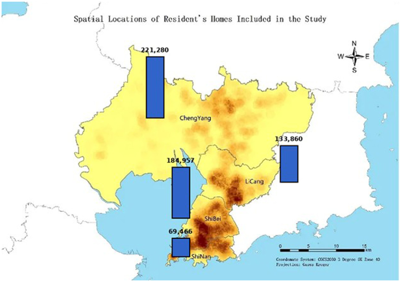
Spatial locations of residents’ homes included in the study.
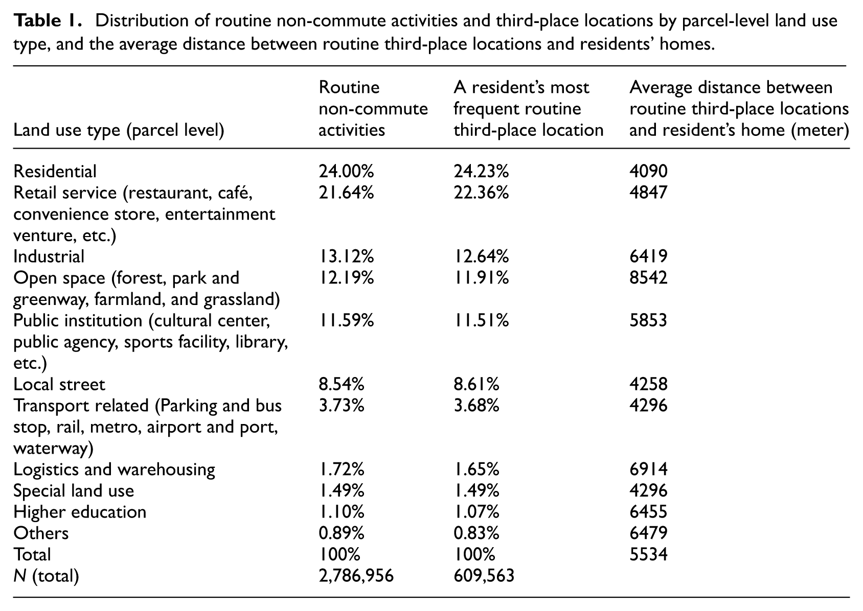
A routine non-commute activity is one performed at a routine third-place location—that is, any location outside of a resident’s home and workplace—where the resident was observed staying for longer than 15-minutes on at least two occasions during weekdays. We identified 2,786,956 routine non-commute activities among 609,563 residents over the five weekdays between 6 and 10 August 2018. The distribution of routine third-place locations reveals a high degree of concentration in resident behavior. Specifically, 56% of residents frequented only a single routine third-place location, while 26.8% visited two, 10.7% had three, and 6.4% had four or more. The fact that over 82% of residents are associated with only one or two distinct locations suggests that our 15-minute, twice-weekly threshold effectively isolates specific, repeated destinations rather than a broad array of transient, incidental points.
For each routine non-commute activity, we extracted the land use information of the location at the parcel level. Additionally, for each resident, we identified the land use type of their most frequently visited routine non-commute locations. The top five location types were
(1) Residential areas: 24.00% of routine non-commute activities and 24.23% most frequent routine third-place locations.
(2) Retail services: 21.64% and 22.36%, respectively.
(3) Industrial areas: 13.12% and 12.64%.
(4) Open spaces (including forests, grasslands, farmlands, parks, and greenways): 12.19% and 11.91%.
(5) Public institutions: 11.59% and 11.51%.
Transport-related locations—including rail, metro, waterways, airports and ports, parking facilities, and bus stops—accounted for only 3.7% and 3.68%, respectively. Table 1 summarizes the distribution of routine non-commute activities happening in different land uses, routine third-place locations, and the average distance between those locations and residents’ homes. Figure 2 illustrates the existing land uses in a Shibei neighborhood, featuring a functional mix of residential, retail, and industrial designations.
Distribution of routine non-commute activities and third-place locations by parcel-level land use type, and the average distance between routine third-place locations and residents’ homes.
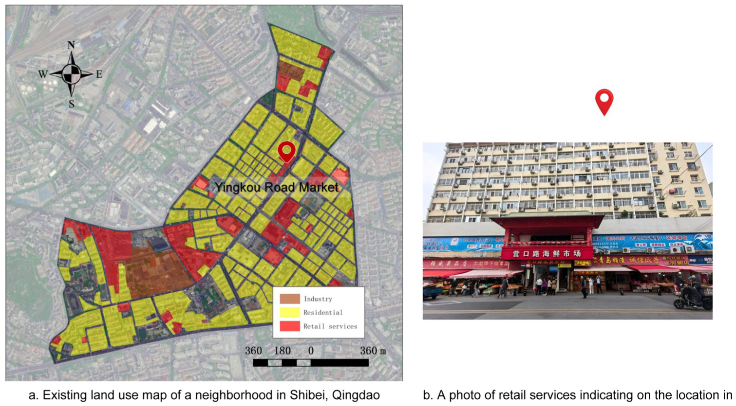
Example of existing land use of a neighborhood in Shibei, Qingdao: (a) existing land use map of a neighborhood in Shibei, Qingdao and (b) a photo of retail services indicating on the location in Figure 2(a).
Residential and industrial areas as third places
Surprisingly, the most frequent routine “third place” locations are classified as residential areas, and industrial zones account for 13.1% of routine non-work activities, making them significant third-place locations as well. This prominence of residential and industrial areas as third places may seem unexpected, but several factors help explain this phenomenon. In China, land use classifications are often more flexible, and residential land use does not exclude non-residential functions. Residential areas frequently incorporate retail services, communal spaces, and facilities that cater to daily needs. Similarly, industrial zones often host a mix of activities beyond manufacturing, including residential spaces and retail services (Tian et al., 2017). This multifunctionality is a legacy of the danwei (work unit) system, established during the socialist period.
The danwei system was designed to be self-sufficient, providing employment, housing, education, healthcare, and recreational amenities for workers and their families (Bray, 2005; Lu and Perry, 1997). As a result, both residential and industrial areas became self-contained communities where residents could fulfill both work and non-work activities without leaving the vicinity. Workers and residents could dine at local restaurants, shop at nearby stores, or participate in leisure activities after work hours without needing to travel far from their workplaces or homes. Despite economic reforms and urbanization transforming China’s urban landscapes, the influence of the danwei model persists in contemporary urban forms (Chai, 2014).
These integrated environments encourage residents to engage in routine non-work activities within both residential and industrial areas. It is crucial to recognize that retail services embedded within these areas are a critical venue to facilitate these activities and social interactions (Rosenbaum, 2006). The proximity of amenities and services fosters a community atmosphere and reduces the need for long-distance travel, effectively turning these areas into significant third places.
Therefore, the high percentage of routine non-work activities occurring in residential and industrial areas reflects the ongoing impact of the danwei system on China’s urban spatial organization. The multifunctional nature of these areas facilitates their use as third places, supporting a variety of social interactions and activities within close proximity to where people live and work.
Retail services and social interaction
Retail services—which encompass convenience stores, restaurants, cafés, entertainment venues, and more—are the second most frequent routine third-place locations. This finding aligns with the concept of third places as informal public gathering spaces that facilitate social interaction and community building (Oldenburg, 1989). The high frequency of visits to retail services highlights their vital role in residents’ social and economic lives, providing opportunities for encounters and strengthening social networks (Jeffres et al., 2009). Figure 3 displays the existing land-use patterns within Qingdao’s Shibei Central Business District, highlighting a dense cluster of large-scale parcels dedicated to retail services.
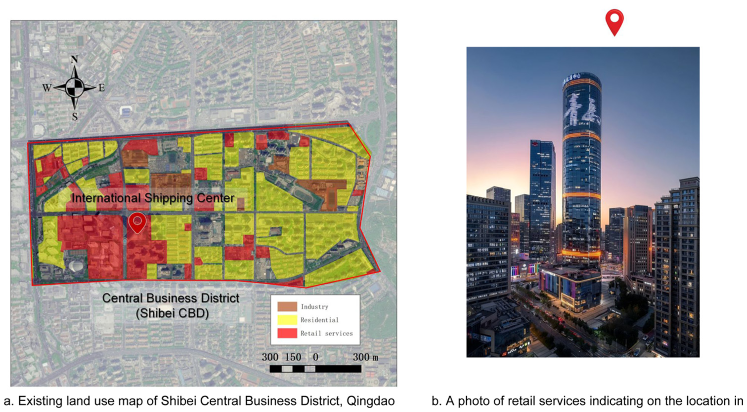
Existing land use of Shibei central business district, Qingdao: (a) existing land use map of Shibei central business district, Qingdao and (b) a photo of retail services indicating on the location in Figure 3(a).
Even though residential and industrial areas are classified as such, the embedded retail services within these areas serve as the primary locations for residents’ non-work activities and social interactions. The integration of retail services into residential and industrial zones emphasizes their central role in residents’ daily routines. Therefore, retail services, whether located within residential, industrial, or commercial areas, are the most important third places for residents’ non-work daily routines and social encounters.
By facilitating daily interactions and providing accessible venues for social engagement, retail services are instrumental in promoting community building and enhancing social networks. They offer environments specifically designed to encourage social interaction, such as comfortable settings in cafés and restaurants or communal experiences in entertainment venues.
Access to open spaces
The average distance from home to open spaces—which account for 12.2% of routine non-work activities—is 8542 m, the longest average distance among different land uses. This suggests that residents are willing to travel considerable distances to access natural environments and recreational areas. Open spaces are essential for physical activity, mental well-being, and social cohesion, especially in densely populated urban areas (Hunter et al., 2019; Jim and Chen, 2006; Liu et al., 2019). The willingness to travel longer distances may reflect a scarcity of accessible green spaces within closer proximity or a preference for specific parks and natural areas offering superior amenities.
Transport-related locations
Transport-related routine locations represent only 3.7% of non-work routine activities. This low percentage indicates that residents spend relatively little time at transport hubs outside of their commuting activities. It may also reflect the efficiency and accessibility of the transportation network in Qingdao, reducing the need for extended stays at these locations.
Availability of third places measured using POIs in 15-minute neighborhoods
Table 2 summarizes the availability of third places—services and facilities—within a 15-minute walking distance from residents’ homes, consistent with the “15-minute city” concept promoting accessible urban environments (Moreno et al., 2021). The data, measured using POIs, reveal both strengths and gaps in local accessibility. There are 20 services and facilities included in the 15-minute neighborhood standards by The Ministry of Housing and Urban-Rural Development of the People’s Republic of China (2018). A significant proportion of residents lack nearby access to senior homes (70% without one within a 5-minute walk), parks or greenways (57.2% without one within a 10-minute walk), elementary schools (44.9% without one within a 10-minute walk), middle schools (40.8% without one within a 15-minute walk), and post offices (50.9% without one within a 15-minute walk). This lack of proximate amenities may impact the well-being of vulnerable populations, such as the elderly and school-aged children, highlighting areas for urban improvement. Conversely, a significant majority of residents have access to wet markets (91.3% within a 10-minute walk), restaurants (96.8%), and bus stops (94.3%). Wet markets play a crucial role in providing fresh produce and fostering community interactions in Chinese cities (Si et al., 2019).
Spatial accessibility of third places measured by POIs in the 15-minute neighborhood context for the residents included in the study.
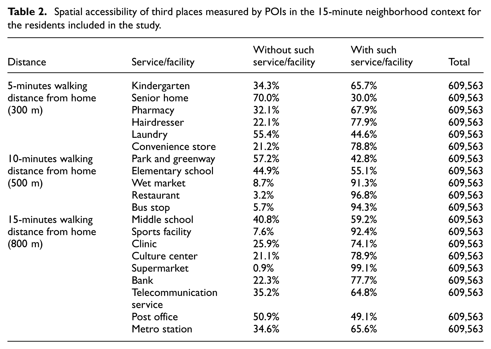
Only 0.3% of respondents lack any 15-minute neighborhood services or facilities. On average, residents have access to 14 services and facilities within a 15-minute walk from their homes, indicating generally good accessibility.
Activity space and routine behaviors
Among the residents included in the study, 26.5% have their homes and workplaces located at the same site and have only one routine third-place location identified. Consequently, it is not possible to create a polygon to define their routine activity space, resulting in a measured activity space of zero. This phenomenon reflects a segment of the population whose daily activities are highly localized, potentially due to the proximity of essential amenities and services within their immediate environment (Kwan, 2013).
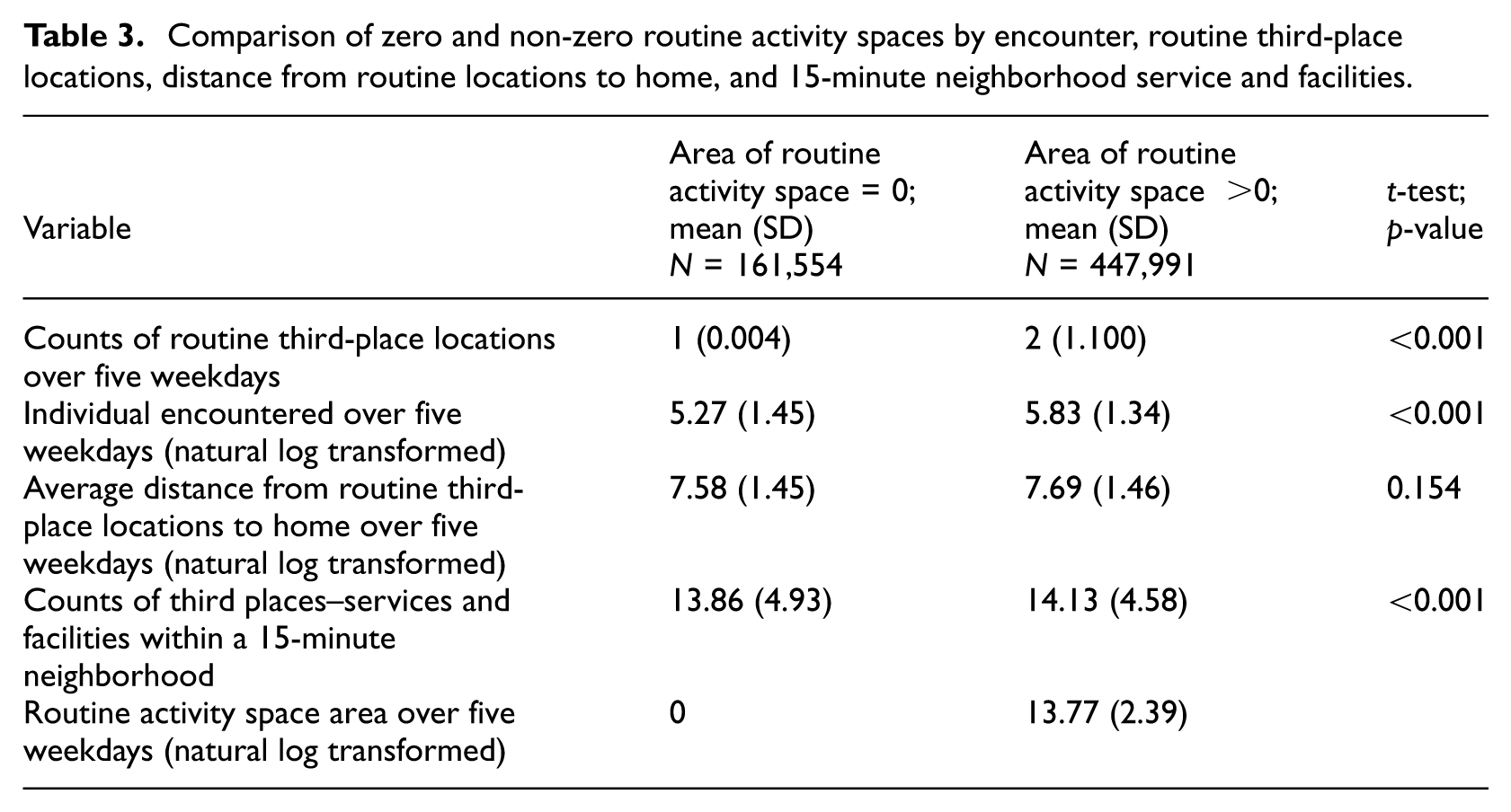
Residents with zero routine activity space were compared with those whose routine activity space is greater than zero in terms of the counts of routine third-place locations identified over five weekdays, individuals encountered, average distance from routine third-place locations to home, and counts of third places—services and facilities—measured using POIs within a 15-minute neighborhood. The t-test results (Table 3) show significant differences between the two groups. Specifically, residents with a non-zero routine activity space have: (1) more routine third-place locations – they visit a greater variety of third places, suggesting a more diverse set of daily activities; (2) more individuals encountered – they have higher levels of social interaction, which could enhance social networks and community engagement; (3) greater access to third places in neighborhoods – they live in areas with more services and facilities within a 15-minute walk, potentially facilitating a broader activity space. These findings indicate that residents with larger activity spaces may benefit from increased opportunities for social interaction and access to amenities. A larger activity space can lead to greater exposure to diverse social groups and resources, potentially enhancing social capital and reducing social isolation (Wong and Shaw, 2011).
Comparison of zero and non-zero routine activity spaces by encounter, routine third-place locations, distance from routine locations to home, and 15-minute neighborhood service and facilities.
Association between individual encounters and activity space
To investigate the factors influencing social contact, we developed a multivariate linear regression model analyzing the association between individual encounters and three key variables: routine activity space area, the number of routine third-place locations, and 15-minute neighborhood accessibility (Table 4). The results indicate that residents with a larger routine activity space area correlate with a higher number of individual encounters, suggesting that spatial mobility expands an individual’s “exposure surface” to others. This aligns with previous research, which suggests that individuals who traverse larger geographic areas tend to have wider social networks and greater access to opportunities (Jones and Pebley, 2014). Similarly, residents who visit a greater number of routine third-place locations are significantly more likely to encounter others. Frequenting diverse third places can enhance social cohesion and collective efficacy within communities (Finlay et al., 2019; Laliberte Rudman et al., 2023). Even when controlling for routine activity space area and the number of routine third-place locations, the 15-minute neighborhood remains a significant predictor. Residents living in areas with a higher density of local amenities—services and facilities—encounter significantly more individuals. This finding demonstrates that the built environment and spatial accessibility of amenities act as catalysts for social contact. By concentrating human activity within a walkable proximity, these environments reduce the friction of distance and increase the probability of spontaneous co-presence (Larsen et al., 2009; Leyden, 2003).
Multivariate linear regression model result for individual encountered over five weekdays.
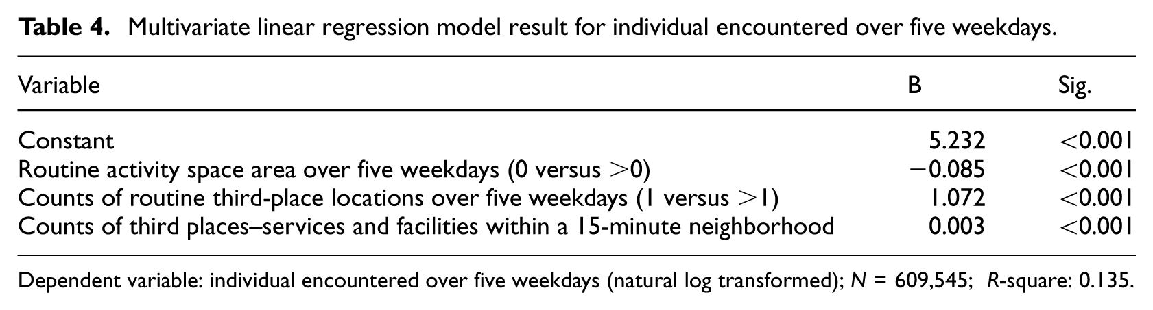
Dependent variable: individual encountered over five weekdays (natural log transformed); N = 609,545; R-square: 0.135.
These findings underscore the role of urban design and planning in creating the preconditions for social capital. While cell signaling data cannot confirm the depth of a social exchange (e.g. a conversation or a sense of belonging), it captures the essential physical prerequisite: spatial-temporal co-presence. By increasing the frequency of “encounters,” high-density, amenity-rich neighborhoods enhance the potential for social interaction. In the framework of “Third Places,” these encounters represent the transition from private isolation to public visibility. The presence of accessible services within a 15-minute walk encourages residents to engage habitually with their local environment. Over time, these repeated encounters in the built environment can facilitate the transition from mere co-presence to social capital and quality of life (Gehl, 2010).
This study has several limitations. First, it focuses exclusively on routine activity spaces over five weekdays, defined by routine non-work activities and routine third-place locations. This approach excludes activities and locations that occur only once during the weekdays, potentially omitting significant aspects of residents’ behaviors. Additionally, activities and locations during weekends are not accounted for, which may overlook important leisure and social activities that typically occur during this time. The five-day observation period may not be sufficient to capture the full range of routine activities and mobility patterns of residents. Furthermore, the study lacks individual demographic and socio-economic data such as age, gender, education, income, and occupation. The absence of these variables limits our ability to analyze how personal characteristics influence activity spaces, third-place utilization, and social interactions. Understanding these factors could provide deeper insights into the variability of residents’ behaviors and help tailor urban planning strategies to diverse population groups. Finally, the mobile signal data are aggregated to cell tower locations, which may not accurately capture the precise land use information of non-work activities. This spatial inaccuracy could affect the validity of our findings related to the destinations of routine non-work activities. Future studies could benefit from higher-resolution location data to improve the accuracy of activity space analyses.
Conclusion
This study provides a granular examination of where and how encounters occur within urban environments in Qingdao, China. By employing mobile cellular signaling data from over 600,000 residents, the research provides an unprecedented spatial analysis of spatial-temporal co-presence during routine, non-commute activities. The findings reveal that retail services emerged as pivotal spatial nodes for these encounters, with third places within residential, industrial, and commercial areas serving as critical anchors. Notably, residents with larger routine activity spaces and enhanced access to neighborhood third places experienced a significantly higher number of interpersonal encounters. This insight goes beyond mere statistical correlation, providing a nuanced understanding of how spatial configuration and environmental design actively shape contact potential.
The research’s findings have profound implications for urban design and planning. By identifying the spatial contexts that facilitate co-location, the study provides actionable insights for urban planners and policymakers. Importantly, the study transcends previous research limitations by focusing on non-commute activities, thereby capturing a more holistic view of urban social life. This approach reveals the rich social interactions that occur outside traditional work-centric models, highlighting the significance of everyday spaces in creating urban social experiences. By demonstrating that urban encounters are deeply rooted in specific urban spatial configurations—not just influenced by social networks or mobility patterns—the research provides a sophisticated understanding of how urban spaces generate physical prerequisites for social connectivity.
By illuminating the spatial arrangement of urban social life, the study reveals how specific places within the city—particularly third places like retail services—serve as crucial sites for the generation of subtle yet significant social interactions. It offers a compelling argument for understanding urban spaces as active, dynamic environments that shape and are shaped by human social practices.
Footnotes
Funding
The authors disclosed receipt of the following financial support for the research, authorship, and/or publication of this article: This study was funded by Qingdao Urban Planning and Design Research Institute in 2024-2024.
Declaration of conflicting interests
The authors declared no potential conflicts of interest with respect to the research, authorship, and/or publication of this article.