
Abstract
The mental mapping method affords a lens into the way people produce and experience space, forms of spatial intelligence, and dynamics of human–environment relations. Mental mapping is the representation of an individual or group’s cognitive map, hand sketched and/or computer-assisted, in drafting and labeling a map or adding to and labeling an already existing map. Despite its long-term, rich, and multifaceted use across the social sciences, I found that the method’s development has been uneven and its analytics ad hoc and piecemeal. Drawing on 32 mental sketch maps and the interviews during which they were drafted, this article provides an extensive review of the method, and details a total of 57 analytic components and techniques drawn from the literature and my own work in this study. I address these analytics from a critical geographic perspective in four categories to follow trends the data reveal. In my discussion, I offer some future guidelines for research with mental sketch mapping (MSM) to continue to extend the method while growing from the body of knowledge already produced. This article contributes a deeper understanding of how the mental maps can inform qualitative studies of people, place, and space across the social sciences.
Keywords
Sarah warned me upfront that her experience of attending an elite women’s college campus “was a mixed experience . . . and I don’t know if I have anything positive to say about it.” I was thrilled. I sought to gather as many stories as possible about how the campus affected students’ and alumnae’s gender and class identity development. Sarah, like each participant in the study, drew a map of the campus as it was during the time of her attendance as part of our interview (see Figure 1). The stories of Sarah’s experiences on campus during the 1950s began to pour out in her map, and as though she could “see” her life again—and anew. The more she drew, the more she remembered, and she shockingly recalled positive and negative experiences. Sarah, who graduated in 1954, even color-coded the campus to reflect those emotions: I’ll make a legend here to explain my map. I chose a less interesting color for those places that were annoying to me or not very helpful to me . . . an emotional legend . . . I’ll put [my first dormitory] in a black square. I was seriously not happy there . . . It’s a one to ten scale . . . Purple was [the founder’s] grave so I’ll put purple embroidery . . . I like it. I love it.
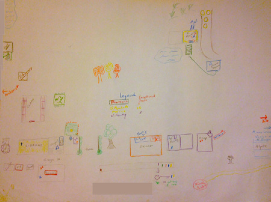
Sarah 1954’s map of the college as it was when she attended it.
While most qualitative methods would have reiterated Sarah’s narrative verbally, the visual and spatial qualitative method of mental mapping afforded another way of seeing her world. Sarah’s map and interview tell us that mental mapping offers a wealth of possibilities to those who use them—but how does it work? And what does the method does it tell us exactly?
At its most summary level, mental mapping affords a lens into the way people produce and experience space, forms of spatial intelligence, and dynamics of human–environment relations ranging from the minute experiences of everyday life to larger structural oppressions (Downs & Stea, 1974, 1977; Gould & White, 1974; Hayden, 1997; Milgram & Jodelet, 1976; Saarinen, 1974, 1984). More specifically, mental mapping is the representation of an individual or group’s cognitive map, hand sketched and/or computer-assisted, in drafting and labeling a map or adding to and labeling an already existing map. Mental maps are often created in association with verbal methods such as interviews, focus groups, and/or ethnography.
The mental mapping method has been a tool for examining the roles and meanings of space and place in everyday lives for over 50 years, and a long-term, rich, and multifaceted use across the social sciences that contributes to illuminating its uses. However, almost all studies using mental maps begin again from the first use of the method (Lynch, 1960), leaving how to use it and what it affords the researcher are left for each researcher to piece together across decades of studies. This article was inspired by the frustration of trying to understand the best practices for applying mental mapping. What are the key components of the mental mapping method? What are the uses to date of mental mapping data, and what do those analytics offer qualitative research? By drawing on past analytics, what new uses of the method can be gleaned? That is, what could Sarah “see” in drawing her map that cannot be shared words alone?
In this article, I provide an informed guide for the examining human–environment relationships through mental mapping, regardless of disciplinary or other methodological approach. My analysis develops from a critical geographic perspective, that is, geography that aims to develop theory, methodologies, and research to combat social exploitation and oppression while building on major and minor economic, political, and social theories. This perspective builds from the idea that space is produced all at once in how it is perceived, conceived, and lived (Lefebvre, 1991). As a critical geographer, I describe how the mental maps can inform qualitative studies of people, place, and space across the social sciences.
I specifically highlight the mental sketch mapping (MSM) version of the method, its most prevalent form, in which participants draft visual maps derived from their cognitive maps of space and the information, emotions, and ideas they hold, whether real and/or imagined (see Brown, 2001; Downs & Stea, 1974; Kitchin, 1994; Wood, 1973). I use “mental mapping” and MSM interchangeably in this article. Drawing on 32 mental maps and the interviews during which they were drafted, a close look at this case study allows for an extensive review of the method, and helped to detail a total of 57 analytic components and techniques drawn from the literature and from my own invention. In previous studies, the use of anywhere a maximum of 5 to 14 analytic components and techniques were considered sufficient (cf. Devlin, 1976; Lynch, 1960), and these analytics only sometimes overlapped. I address these analytics in four categories to follow trends the data reveal. In my discussion, I offer some future guidelines for research with MSM to continue to extend the method while growing from the body of knowledge already produced.
Literature Review
Psychologist Edward Tolman (1948) first formally defined “cognitive mapping” as how humans think on and about space and also how they reflect and act on those thoughts in their everyday behaviors. Scholars agree that spatial knowledge exists; however, they debate the existence of preconstructed cognitive maps carried in our minds and if these maps are analogous to maps, metaphors of maps, or hypothetical constructs (Kitchin, 1994), while others argue that navigating through a space leads to spatial knowledge (Heft, 1996; Ingold, 2000). I build from both approaches and understand mental maps to be processual and representational, that is, never complete (Kitchin & Dodge, 2007) and, therefore, never fully remembered or remembered. As such, while scholars often use the terms “cognitive mapping” and “mental mapping” interchangeably, I rely on the term “mental maps” to describe those representative maps of spaces derived from cognitive maps (Wood, 1973, 1992).
The mental mapping literature begins in urban planner Lynch’s seminal The Image of the City (Lynch, 1960) that examines the relationships people have with elements of the physical city to conduct their lives to produce user-informed city planning. His method of having participants sketch, describe, and label maps has served as the basis for other mental mapping studies. While understanding of spatial knowledge and cognition has increased significantly since 1960, Lynch’s method and analytics continue to be the de facto description for using the method in that scholars return to his work rather than developing more comprehensive study of the method across studies (see Devlin, 1976; Milgram & Jodelet, 1976; Powell, 2010).
Mental mapping studies in the 1960s and 1970s focused on extending the method through a psychological lens, particularly around environment-behavior studies (Devlin, 1976; Downs & Stea, 1974, 1977; Gould & White, 1974; Milgram & Jodelet, 1976). More recently, the method has been useful in visualizing other dynamics of human–environment relations, such as sense of place, movement, environmental perception and cognition, and even illuminating sociospatial inequalities. Saarinen’s (1974) work with maps of the world gathered from children from four countries with varied economies produced maps whose perceptions of geography were construed by residence and privilege. He found that MSM “can elicit responses that might be difficult to obtain by other means” because it reveals an “invisible landscape (i.e., the ‘invisible’ effects of social prestige)” (1974, p. 110).
Since the 1970s, architectural historians, psychologists, planners, geographers, and scholars in other fields have drawn on mental maps to articulate more complex and often invisibilized stories of the marginalized (see Gould & White, 1974), including the limitations and oppressions of racial and ethnic minorities (Hayden, 1997), sexual minorities (Brown, 2001), or disenfranchised youth (Krueger, 2010). Working from the fields of geography and arts education, respectively, Dennis (2006) and Powell (2010) used mental maps in mixed method approaches to inform their work with impoverished city residents and city planners of Newark, New Jersey, and Panama. Social psychologist Krueger (2010) used MSM in her participatory action research (PAR) project with students to examine affects of NYC school surveillance in on their sense of safety and education. Throughout this work, mental mapping is articulated as a way of visually speaking through places what words alone cannot articulate.
Others criticize the MSM method for depending too heavily on participants’ inevitably varied drawing skills (Kitchin & Freundschuh, 2000), and some scholars have debated the priority visual data are given in studies of space and place (Ingold, 2000). As the attention and respect given to visual methods grow, it is striking to point out the opposite: that the ability for participants to verbally express themselves and the priority given this form of data is rarely, if ever, questioned. Education theorist Howard Gardner’s (1993) multiple intelligences theory argues that individuals have 12 types of multiple intelligences, more than the mathematical–verbal skills society prioritizes. It is inevitable that researchers have ignored a wealth of data by not considering these multiple intelligences. Mental maps are also helpful in expressing change over time. Taylor (2007) found mental maps helpful in supporting her working class participants’ discussions of their sociospatial life histories over the life cycle.
Some versions of the method fall outside the scope of this article. For example, studies of identity mapping follow trajectories of identity development (Katsiaficas, Futch, Fine, & Sirin, 2011), and social mapping traces social networks while concept mapping follows the progression of concepts and ideas (Powell, 2010). These methods are highly informative for formulating new ways of thinking about mental mapping, which especially highlights the role of space and place in participants’ lives. In regard to the ways of deploying the method itself, another popular use of the mental mapping method is to offer participant an already drawn map and ask them to label it (Gould & White, 1974). Many of the analytics that I present here depend on a participant drawing and labeling a map in front of the researcher, so that only noting or labeling predrawn maps depends on the extent of sketching to allow for all of the analytics discussed here (see Brown, 2001). In other studies, the mental map is not the focus of or the main tool for guiding the interview; for example, it can be drawn before the meeting and then used as a discussion point (Dennis, 2006). A prerecorded map of the MSM method can still include the order of items drawn; participants can number elements as they draw them; however, this may disallow deeper reflection of the map by the participant in the interview.
Method Use and Components
Case Study: Gender Identity Development on an Elite College Campus
The maps used as a case study for this article grew from the question: How does the built environment of the elite campus affect and reflect the identity development of its female-identified students in regard to their gender identity development throughout generations? I conducted individual interviews and mental mapping exercises with 32 alumnae and students of such a college to their understanding each woman’s experience of gender identity and power as a result of attending that college specific to her generation. Conducted in 2007, participants were graduates or students of an elite women’s college, Mount Holyoke College (MHC), from classes spanning 1937 through 2007.
Located in semirural western Massachusetts, MHC was founded in 1837 and it is one of the 49 remaining women’s colleges in the country. It possesses one of the 125 largest endowments of any college in the United States, and consistently ranks in the top 35 of the most selective schools and as one of the most beautiful campuses. The campus was composed of anywhere from 60 to 75 buildings during the period of study, many dating to the late 1800s. Each building has an honorific name, and each structure is part of the vibrant and often discussed college history. Most students live in on-campus dormitories so that participants often possessed years of memories of living, working, and studying on campus. Together, the rolling hills, wooded areas, two lakes, and the predominantly Victorian Gothic residential and academic buildings covered with ivy typify an elite New England college campus. Alumnae expressed their great sense of access to the campus, as a function of the privilege of the institution and the women-only environment that invoked a greater sense of safety and, in turn, trust. Social practices on campus also portray practices of elitism. Students attended formal dinners in their dining halls ranging from every night (1930s) to every week (1970s) to every month (1990s, 2000s).
Four to five graduates or students per generation allowed me to look for generational shifts in understanding. Participants are denoted by a pseudonym and actual year of graduation, that is, Sarah 1954 graduated in 1954. I recruited participants through snowball sampling and online notices through MHC’s listservs, as well as alumnae clubs and groups. Most participants identified as White or WASP (White Anglo-Saxon Protestant), heterosexual, and middle or upper-middle class. Findings indicate that participants were encouraged and hindered in reworking gender norms through the privileges afforded by the elite social and physical campus (Gieseking, 2007).
Participants drafted and labeled spatial mental sketch maps of the college as it was during their attendance throughout our conversations, which allowed each woman a chance to share her story in depth and in an one-on-one setting. Asking some people to talk about how a “space” mattered to them can be awkward. I chose to use the MSM method to inspire conversation focused on the social and emotional meanings of a physical geographic place (see Saarinen, 1974), and therefore overcome that awkwardness. While cartography is imagined as the work of trained experts, map-making is an activity that enters the everyday life often only in childhood and young adulthood as a learning exercise or play, particularly in the United States. At the same time, this project involved “studying up,” that is, studying the understudied population of those with more power, money, and/or social status, a group perhaps hesitant to represent themselves or institutions in a bad light. It was hoped the more playful method of drawing and labeling might help participants recall such times and relax into a more youthful state (see Winnicott, 1992).
Designing and Conducting the Interview and Spatial Mental Sketch Mapping Exercise
Mental mapping, unlike verbal-only methods such as interviewing, always depends on various social and material components. Little discussion has been awarded to these materials in the literature although I found that each drastically affects desired outcomes. Paper can vary in size, shape, and quality, and the size and type of paper has been known to influence the details of maps produced (Kitchin & Freundschuh, 2000). In choosing an archival quality paper of 2.5 feet by 1.5 feet, participants were afforded room to draw the campus as they saw fit. The archival quality of the paper led a few participants to remark that it made them feel their map and their stories were important. I chose to bring regular lead pencils, a pen, and two sets of colored drawing pencils (1 of 8, 1 of 64) to afford erasing, permanence, and the use of color. Interviews averaged 2 hr and 15 min, allowing time to create detailed maps.
The method of obtaining a map in an interview is often outlined around Lynch’s (1960, Appendix B) original interview schema, because, as must be reiterated, other scholars continue to return to this format without other more holistic examinations of the method. I attempted the same but found his strategy wanting for my project. Lynch’s steps are as follows: (#1) asking what first came to mind in terms of the image of the space; (#2) requesting that they draw a map of the space; and (#3) asking for their detailed movements on an average day. Similarly, I asked, I would like you to draw a map of the college as it was during your attendance. Try to cover all of the main features. I don’t expect an accurate drawing—just a rough sketch of what you remember. It’s not important if you can’t remember the names of places but do label those places you can recall. I’ll take notes as you draw and talk as we go along.
After around 20 min had passed I thanked participants for their initial map, and then encouraged adding to and labeling the map throughout. When requesting these women to describe their average day, I asked them, following Lynch’s method, to picture themselves making a trip across campus and, in doing so, describe the sequence of things and people they would see, hear, or interact with along the way, including any paths and places of import.
I simultaneously expanded on the standard Lynch technique to achieve the goals of my study and focus on the relationship between people and their spaces rather than the design of the space. Between the first two questions, I asked how the participant and the participant’s friends saw them in college (#1a), and how they generally regarded their time then (#1b), similar to Devlin’s (1976) tactic to relax and situate her participants. These questions encouraged participants to not only remember the space but to place themselves within it. Franny 2006 shared, Um, it just feels really . . . it just feels really comfortable . . . I can remember so many of my memories of Mount Holyoke taking place, right here [points to center of campus on her map], which I think that’s why [I drew] this part of the campus is so big.
Participants require clear and exact directions for drawing the map (#2), because unlike verbal interchange, a more permanent version of their data is immediately obvious in the form of a map. I often reassured participants this was not a test of memory or skill when they would ask or imply it was such, but another way to share their stories. Asking participants to cover the main features of the campus but to focus on what they remembered when they attended the college helped them focus on their versions and not the more general portrayal (#3).
These initial, brief “grand tour” questions also allowed participants to open up and express everyday life details throughout the rest of the interview when we discussed their experiences and emotions on campus through questions about their shifting ideas of women, power, and education (#4). I developed this technique from Dennis (2006) and Krueger (2010) who use the maps as conversation points for further discussion. Surprisingly, the more detailed series of queries (#4) afforded participants ways to discuss deeper narratives of self and place, that is, as a place one suffered from depression or overcame past abuse. I reminded them to label the map and indicate these stories on the map throughout our conversations, which was critical to stress as many participants were not comfortable doing so unless encouraged. Finally, I briefly posed questions near the interview’s conclusion regarding situations that may have altered participants’ memories of the campus (#5), that is, their frequency of visits to the campus now. To account for other possible effects of proximity, I conducted half of the interviews with those who lived near the college or at the college (i.e., students), and the other interviews were conducted in New York City with residents thereof.
The order of these questions proved key for getting participants to open up and recall their experiences; this new finding must be underscored. Placing the mapping exercise near the beginning of the interview helped participants to focus on the campus, and this assisted me as the researcher in examining the sometimes difficult question of the meaning of a space. Overall it proved most significant to describe and enact the mapping process as one of mutual exploration.
Analytic Techniques and Components
The interviews and maps developed as complementary parts of these women’s stories, and as such I analyzed them as a whole, each map with its interview. I foremost transcribed and closely read the interview transcripts, and then I reviewed each map in detail in association with its associated transcript and notes. Wanda 1999’s statement, “I think it’s tough to separate the experience from the campus,” speaks to this inseparability. I analyzed maps and transcripts generationally to identify trends over or during certain periods, and scholars may find alternative data categories helpful. While Lynch (1960) compiled the maps he gathered in his urban planning study, Powell (2010) described an exciting method of rectifying hand-drawn maps en masse to official city maps as a specific way to present data to city for planners. I suggest that merely compiling individual maps for analysis is only useful when a study’s aim is to create a collective vision. The researcher could ask individuals to share their maps collectively on a larger map to allow for individuals to share as they see fit (see Gieseking, 2012).
My original goal in this study was to provide deeper insight into the role of space in their identity development and processes within the space that affected this development. The outcomes were much wider reaching and informative. Maps from this study tended to fall into two types: maps drawn to convey emotions and experiences related to the space, and maps replicating the campus while emotional and experiential memories were described in words. It is indeterminable if this split is generalizable, but this finding speaks to supporting the multiple intelligences of participants in using verbal and visual methods.
After scouring the mental mapping literature, I created a list of 36 analytic techniques and components but found these were insufficient to explain my findings. Thematic coding of my own study added a further 21 analytics, which I developed or extended to fill in holes in the literature for 57 analytic techniques and components. Overall these analytics summarize, clarify, and expand the present literature on the mental mapping method. These analytics offer data in counts, percentages, yes/no answers, and/or qualitative trends. My discussion of the analytics here can only attend to some of these analytics at length (see Table 1) so that the remainder are given summary descriptions in another table (see Table 2). I use “techniques” to define ways to examine a map, while “components” are map elements or part of the map’s production.
Citations and Categories of Analytic Techniques and Components Discussed in Text.
Note. MOM = Mechanics of method; DE = Drawing element; NOP = narratives of place; P = personalization.
Citations, Categories, and Descriptions of Analytic Techniques and Components Not Discussed in Text.
Note. MOM = Mechanics of method; DE = Drawing element; NOP = narratives of place; P = personalization.
I culled and then categorized the analytics to trace trends in my project’s findings. Mechanics of method (MOM) includes 17 analytics that examine a map’s accurate representation of reality, and participants’ reading of those efforts. Drawing elements (DEs) are 12 analytics that entail a spatial analysis of core map elements—how a map is drawn, such as including a legend or north arrow. The latter two categories reflect on social and psychological nuances afforded by mental mapping. The 19 components and techniques I categorize under narratives of place (NOP) show how the physical, remembered, and sometimes imagined elements of place play a role in these women’s understandings of their identities and the campus itself. The final category, personalization (P) includes nine analytics that were likely to reveal the participants’ most personal experiences and deepest emotions. I encourage other scholars to group their own analytics together as best supports their study’s objectives and outcomes.
Mechanics of Method
It includes the analytic techniques and components that underscore the traditional notions of how a map portrays a convincing representation of spatial reality, as well as participants’ level of focus on and sense of success in that process. With regard to the sequence of elements drawn, I identified a trend for participants to draw the campus region by region, that is, south to north, and so on, and often focused on the area where most of their memories were clustered (see discussion of Figure 3). Such lustering indicates a memory of place that reveals itself regionally rather than through specific buildings. Recording sequences made for an easy count of drawn items. While not a stand-alone measure, the average number of 59 items drawn per map (max 116, min 30) indicates that all participants had a significant amount to share about their experiences through the MSM process. Such thoroughness also points to a focused practice of mapping and the richness of that data.
The ability to label a map indicated an understanding beyond spatial form to that of spatial meaning. Participants were often eager to label map elements, sometimes labeling in acronyms, slang, and/or abbreviations. Participants used these abbreviated or slang labels to highlight their familiarity, sense of comfort, and intimacy with a place. Abbreviations, and so on, were more likely to be verbalized than mapped, indicating that labeling a map is more formal than speaking. Most participants, like Sarah, continued to label the map throughout the interview, that is, participants experienced mapping as an ongoing process and opened up through their mapping.
Criticisms leveled against MSM point out that it fails to reveal all a participant knows, particularly as a test to accurately portray subjects’ ability to depict a site (Kitchin & Freundschuh, 2000). Overall participants did not produce maps that mirrored the “real” space of the campus, although Downs and Stea’s (1977) found this to be an achievable goal for participants when they conducted a study with the intent to gather such “real” maps. Nearly two thirds of participants were likely to place at least a few buildings or sectors of the campus in incorrect locations, and often did so when discussing emotional experiences within a building or area. Fran 1938 had only positive memories of her time on campus and wanted me to know, “I’m sure I missed something.” Quite the opposite, Janice 1969 pined for her college drawing courses and the life she imagined as an architect and added deeper details, even drawing most of campus three-dimensionally (see Figure 2). As she sketched, she decided to add more details and recalled an important memory from her first semester at the college: “In my art class, I was supposed to draw a window and I drew, I attempted to draw one of the octagonal kind of windows and the idea was to have the leaves sticking out” (see center left, Figure 2). These variations in the details of the maps—not specific to years since graduation—indicate that my directions did in fact stimulate more personal versions of the campus than merely a replica. The average number of years since spending a significant time in the space was 30 (max 70, min 0). Those who graduated more recently, frequently visited the campus, and/or resided nearby were not more likely to draw more accurate or more detailed maps. All together, the MOM techniques and components are helpful clarifying the more processual elements of map-making.
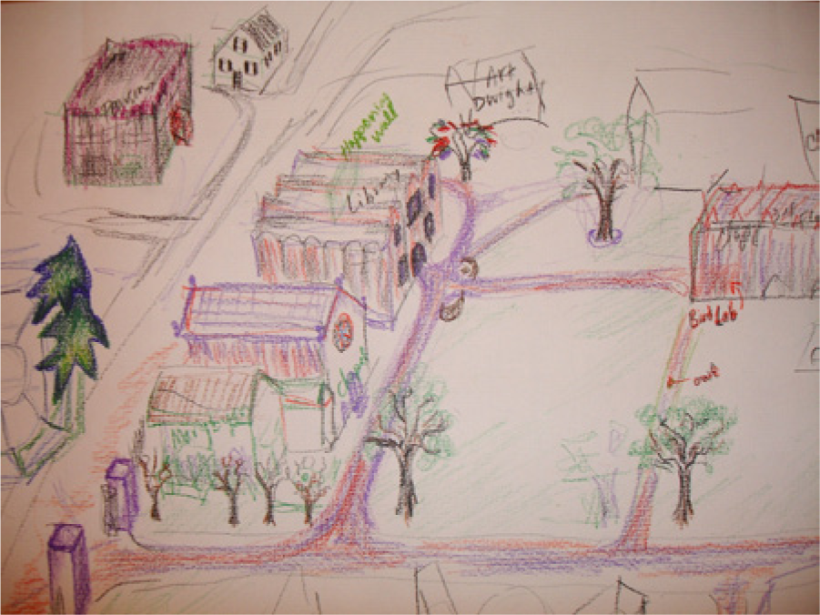
Detail of Janice 1969’s map of the college as it was when she attended it.
Like their tendency to draw their map in regions, most participants were likely to group key elements of the space in relation to one another whether they replicated the physical campus (see Milgram & Jodelet, 1976). Linda 1937 produced her map by navigating the space and placing the buildings and campus markers in relation: Well, let me see, that was Pageant Field. Have I lost my way? No, I don’t think so. No, Pratt was over here. And that’s just about where it was, at the end of that street was Pratt Music Building because that’s where all of the choir and glee club rehearsals took place.
More than two thirds of participants expressed significant drawing anxiety (three or more references that their map would not be clear or interesting enough) or some drawing anxiety (one or two mentions). These expressions ranged from brief hesitation to extreme self-doubt; drawing anxiety is often linked to public drawing (Winnicott, 1992). While a long debate has ensued regarding spatial mental mapping’s validity due to participants’ varying level of drawing skills (cf. Kitchin & Freundschuh, 2000), I found that while participants’ drawing skills certainly differed—often by their own declaration—these variations did not affect my analysis or the data I sought to draw from the maps.
A few participants discussed worries about their map being “good enough” alongside stories of self-confidence. Linda 1937 talked at length about her self-doubt during college, but, in drawing the campus library, reconnected to her sense of self when discussing the library: I have always been crazy about the reading room. As you know it’s a replica of Westminster Hall in London, on a somewhat smaller scale. I just loved that room. I was thrilled when I was given a carrel. Honor students were allowed to have carrels in the stacks. I loved it because it made me feel like a scholar.
While her map barely conveyed much of the space beyond outlines of physical space, she reoutlined the T-shaped library throughout our conversation so that it is the only space with literal weight on the paper. Literally and metaphorically, this is where Linda found her footing. Beyond fears and mentions of anxiety, most participants enjoyed the mapping process, like Fran 1938 and Kelly 1969 who found it “fun” and a form of “playing.” These findings demonstrate the method can at times be nervous-making, but enjoyable overall for many.
Drawing Elements
DEs entail a basic spatial analysis of how a map is drawn, paying particular attention to the ways maps are assume to look and convey knowledge. Many of these techniques and components are spatial analytics inspired from the work of Monmonier (1996) whose work affords ways to see how maps can be in their presentation through color, projection, and so on. Perhaps the most captivating quality of the map for the onlooker—and for many participants—is what is placed at its center, at its borders, and if and how color is used. Lauren 2006 placed her dorm of 3 years in the center of the map (see Figure 3), and then reflected that its proportion was “huge” and in the wrong location, adding: “So I definitely think of [my dorm] Mead as being like the center of the universe on campus.” A technique developed by the critical geographers Downs and Stea (1977), examining the paper borders of Sarah 1954’s map (Figure 1) tells us that the arrows she drew to Yale University and Amherst College, where she met and dated men, and show how the physical space of the campus extended to these other areas for her. Furthermore, Sarah’s emotional scale was a powerful and rare example of how color can convey emotion. Some participants chose not to use the color; some remarked that their emotions were not associated with colors they used (red for anger, etc.), while others found that helpful, like Kelly 1969 who drew most of her map in green to elaborate the sense of growth and healing she felt about her time on campus. It is essential to listen to each participant’s own analysis.
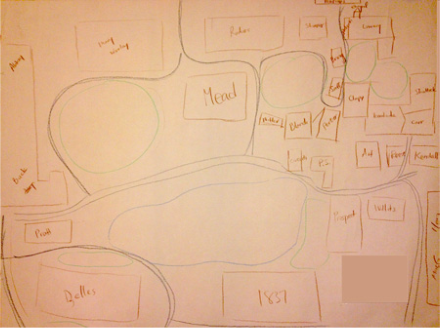
Lauren 2006’s map of the college as it was when she attended it.
Two thirds of participants also relied on mapping other symbols to mark spaces of import, often in regard to significant emotions. For example, Danielle 2006 used hearts, stars, and shining suns to mark positive experiences around campus (see Figure 4). She doodled symbol after symbol to reflect her shifting understanding of her gender identity and overall self-identity including a high heel, cargo shorts, a sun, a rocket, painting her rich experience on top of the campus she sketched in black and white. To my surprise, one third of participants made a legend. Legends often afforded a way to see how participants framed themselves and their spaces.
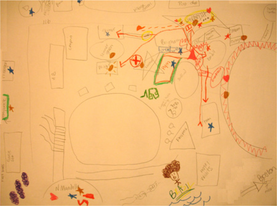
Danielle 2006’s map of the college as it was when she attended it.
Saarinen (1974) found that U.S. citizens drew maps of the United States depicting their city or region as larger than it tended to be, and less mentioned states and cities fell off the map completely. With this in mind, I took account of the accuracy of the scale of map elements in relation to one another. Half of the participants kept all of their map elements at the same scale. While participants’ drawing skills varied, I found a trend that those spaces made extremely large or small to bear respective greater or more positive, or lesser or more negative import to participants. Such DEs help is to see the use of standard map components anew.
Narratives of Place
The components and techniques categorized under NOP include those analytics that help us to see how the physical, remembered, and imagined space of the campus intersect in production of a place in how it all at once conceived, perceived, and lived. I took note that all participants included built environment elements of the campus such as buildings and human-made elements. Correspondingly, I noted that most participants included physical environment elements, that is, more “natural” elements such as the campus lakes and green areas. Considering the high number of participants who included both, it is evident that built and more natural campus elements were important to depicting the campus.
What proved most useful for data gathering was asking participants to relive their experience of the space by mentally walking through it (see also Powell, 2010). Fran 1938 laughed as she remembered every buildings’ name and location as if she were walking through campus, and added, “I don’t think I would remember this well if I didn’t do that damned morning mail.” As such participants were required to move from the cartographer’s standard “God’s eye view” projection from above that critical geography seeks to work against relying solely on to relive the embodied experiences of moving through the campus (see also Powell, 2010). Such a shift supports Kwan’s (2002) call for feminist mapping projects that explore and enable working from the scale of the body. Most participants found that this inspired them to recall forgotten names of buildings or on-campus experiences they said they had not recalled in years or even decades. One of the most powerful examples was Cathy who graduated in 1951 who was indifferent to the mapping exercise. When drafting her map (Figure 2, Question #2), she could give names to just more than half the buildings she mapped and mislabeled many buildings including her senior dormitory, Porter Hall. However, inquiring about her average day (#3) brought the campus to life. She vividly recalled, I was walking and singing “On A Slow Boat to China” going . . .into Clapp [an academic building] . . . I was with another friend of mine . . . early in the morning too and then I remember running back to wait tables. [Draws a thick line.] Just tearing back at noon to be there in time to wait tables. And . . . I have wonderful memories of . . . Porter! [Nods.] My roommate . . . and I lived in this room here . . . you know the little alcove here, this little out pocket there? . . .a nice big room with a bay window. It was wonderful.
These embodied memories led her to remember more of the names for all campus buildings, and correct most of the names she had mislabeled. The mental mapping process in the interviews and discussing the map often lead to unexpected associations and memories.
Building from scholars’ interest in the accuracy of labels given to spaces (Lynch, 1960; Saarinen, 1974), I found the only generation able to accurately label (80%+) the space of the campus were those students still on campus. As half of each generation could also correctly label their maps, it is not indicative that the amount of time since graduating affect spatial memories. In fact, the most accurate map by an alumna (rather than a student) was drawn by a member of the class of 1945.
Lynch’s (1960) analytics are the most well known and often used in mental mapping studies: districts, edges, nodes, landmarks, and paths. Almost all participants clustered their maps into districts or intentionally clustered regions. While the academic and residential buildings are clustered on the physical campus, most participants portrayed them as even more tightly knit in their maps. Just more than half of the participants made use of edges, which examine the self-defined boundaries of the campus per participants, unlike what was depicted along borders of the paper map as a DE. Most women marked the edges of campus by a series of roads. Participants also included marginalia of off-campus memories who formed their on-campus experiences, namely boyfriends, girlfriends, and friends who attended other colleges. Sarah 1954 left white space and drew arrows to reflect her many trips to Yale University and Amherst College for dates that she felt were key to her campus experience. Only a few participants used nodes, those key intersections and junctions of paths. Participants discussed important intersections as the conversations sitting around dining room tables, or in dorm rooms or classrooms, rather than at outdoor crossroads key for Lynch’s urban planning study.
To determine campus landmarks—places popular or of note—I gather participants’ most often referenced images of the campus (#1). These landmarks included the campus’ two lakes, main reading room of the library, entry gate, clock tower, and the founder’s grave, among others. All participants included at least two of these landmarks in their maps, indicating a powerful, shared geographical imaginary to the campus itself. It was not surprising that only half of the participants included paths and roads in their maps (Lynch, 1960), as students were not allowed cars in the past and have a bus system to access nearby towns and colleges. Correspondingly, landmarks read as more useful markers for spatial definition and navigation. Nearly two thirds of participants included personal paths, theirs and those of their friends. Danielle 2006’s depicted her everyday pathways in bright pink because they felt like some of the best parts of her day (see Figure 4), and Penelope 1974 said these paths were important to her because “you’d walk and talk with people as you went.” One personal path that showed up over the 70 years of participants’ experiences was paths walked and drew from dormitories to classes, often through the center of the central green. Generation after generation, the ability (or inability) to forge one’s own path is as important as those paths laid out for us. These analytics demonstrate that in the study of human–environment relations, mental mapping affords significant insights into how individuals produce their places.
Personalization
The final category, personalization, includes analytic techniques that were likely to reveal participants’ deepest experiences and emotions. When not viewed as a test but rather as a complement to the qualitative telling of lived experience, mental maps provide data in accuracies and inaccuracies (Saarinen, 1974). All participants included what possesses personal meaning on the map, like Kelly 1969 who began her map stating, “For some reason I’m starting with the chapel. I’m a very spiritual person.” At the same time, only half of the participants included what lacks personal meaning that I found exciting for critical geography work because it extends the meaning of place beyond the personal to the cultural or social. A few participants made sure to map the stables and equestrian center in the northwestern campus even if they had never visited them because they felt they represented the space. Remembering her intense depression in college, Claire 1986 left off the two dorms where the multilanguage lunches were held because “I was aware freedom was a possibility here but I couldn’t take it.” Similarly, Saarinen (1974, 1984) found proximity to be a key factor in U.S. residents’ maps of the United States, wherein they were more likely to include other states in proximity to them. This again proved true in that two thirds of participants tended to depict the environment closer to where they resided and/or worked on campus, regardless of how much time had passed.
I also found that first-drawn elements and last-drawn elements were often specific to a person’s experiences. The first-drawn elements often the residence hall where participants held the most significant and best memories of their experiences, such as Lauren 2006’s depiction of the dorm where she resided for 3 years as imaginatively taking up a quarter of campus. Many other participants first drew the main street followed by the ornate, entry gate of the campus, which was their own entryway on to the campus when beginning college. Others first drew the campus roads to create a structure from which to draw the rest of the campus. Kitchin and Freundschuh (2000) have argued that first-drawn elements can create “associational dependence” for how a space is mapped thereafter. However, some participants suggested these initial framings were intentional, and these first elements helped me to frame how the participant enters and sees the space. Last-drawn elements were often not important. Five participants included a depiction of themselves in their maps, again echoing the feminist aspect of this method to bring mapping to the scale of the body. In sum, the personalization category shows the most unique and psychologically revealing analytic components and techniques for mental mapping.
Discussion and Conclusion
Vanessa 1995 began our interview by saying, And I remember everything. It’s not, I mean, it’s like yesterday . . . I have memories in all of these places, all different types of memories. I had my first kiss in his weird little, where that field was behind the music hall. Everything means something.
Like Vanessa’s sentiment regarding the inextricably bound stories of place, memory, and identity, Sarah, Janice, Lauren, and Danielle’s maps and stories, and the stories of many other participants reveal that mental mapping affords significant insights into the study of human–environment relations not always gleaned by verbal interchange alone. MSM evokes “the lived experience of social, cultural, and political issues related to place” (Powell, 2010, p. 539), as well as the way places live within and produce people, societies, cultures, and politics. The most exciting insight that mental mapping affords social science research is another way of literally seeing and hearing participants’ experiences that may go unrecorded if the studies of space and place rely solely on verbal interchange. Like Wanda 1999 shared, “I think it’s tough to separate the experience from the campus,” studies of space and place are enriched by intersecting rather than separating layers of participants’ experiences, identities, and practices in place. The most important contribution of this article is that it stitches together five decades of work using the method and offers a wealth of uses for research attentive to the study of space and place across the social sciences. Looking back over the knowledge and insights into MSM that had gone overlooked for so many years, in this section I offer some future guidelines for the method building from my critical geographic approach to working with mental mapping.
While we can and will return to Lynch’s inaugural contribution, there are other ways of seeing where we go from here with mental mapping. The analytics I summarize and introduce in this article dig into what geographers Downs and Stea (1977) called the “whereness” and “whatness” of participants’ experience, that is, where things happen and what is important about them to the place, person, and relationship between them. The elements of the method and 57 analytic techniques and components for mental mapping data compiled and many developed here for the first time affords researchers’ insights into what ends MSM can be useful in future scholarship. The techniques and components discussed here are far from exhaustive and scholars in various fields will have differing aims, but many if not all of these analytics are broad enough can be drawn on and/or reworked to be useful across social scientific research, hopefully to develop the method further. Researchers should keep in mind that the categories I used to track trends in findings are not fixed, and are encouraged to build their own categories as necessary.
The analytics in this article move between scales, back and forth between global processes into the intimate embodied experience, demonstrates how spatial mental sketch maps draw on precognition and wayfinding in their production (Heft, 1996; Ingold, 2000; see also Powell, 2010). In fact, Alice 1957’s description of her walk to Monday morning class her first semester of college was an unconscious embodied experience. She remembered, The side entrance to Clapp [academic building] . . . it’s burned into my brain [taps table hard] because that’s where . . . that big classroom was. (Laughs.) I can hear my Massachusetts accent come out, which is so strange why I’m doing that!
Returning to Gardner’s (1993) multiple intelligences theoretical frame, MSM affords participants a way to convey knowledge and experience in a different form. In addition to providing an additional outlet for literally and metaphorically mapping multiple intelligences, there is use to revealing and handling the emotional and psychological to the MSM method that is surely of use to researchers (see also Kitchin, 1994). The use of this more playful method of drawing and labeling a map did assist participants in recalling and relaxing into a more youthful state as intended (cf. Winnicott, 1992), and would equally be useful for researchers working with youth or dealing with a subject that may be best addressed through play. Last, future uses of MSM can enable more participatory research, encouraging participants to tell their stories in their own voices and to draw out their own experiences in their own hands.
I suggest that this deeper understanding of the MSM method and its analytics can lend itself beyond the spatial turn in new and exciting directions. Already other forms of mapping inform ways of connecting visual identity mapping to trace trends in individual and group identity developments (Katsiaficas et al., 2011). Arts educator Powell (2010) argued for a form of aesthetic mapping—also drawing on methods of photography, collage, and diagrams, and booklets—that produce a visual in MSM that prompts “multisensory experiences of space, time, and place in nonlinear ways” (p. 540). Furthermore, the method of social mapping helps to network relationships and flows of social capital, and the concept mapping method elicits the progress of ideas (see Powell, 2010). Critical geographers increasingly find ways to incorporate more qualitative methods like mental mapping into GIS studies and extending quantitative work in exciting new directions (Dennis, 2006; Kwan, 2002). Perhaps most exciting for work around issues of social and spatial justice, the mental mapping method is being used in efforts of countermapping, that is, putting mapping and maps in the hands of people to allow for different points of views and ways of understanding and increasing agency in understanding, rights, and use to spaces (Dalton & Mason-Deese, 2012; Manoff, 2011). In the future of mapping, spatial and beyond, mental mapping projects will provide a wealth of information to affect the everyday lives of the oppressed and marginalized, policy and planning at all scales, and theoretical contributions of human–environment relations. Regardless the field or aim of the researcher who seeks to use MSM as a method, this article demonstrates that MSM data afford participants and researchers alike a way to share and see more multidimensional stories of themselves and their experiences through the lens of space and place.
Footnotes
Acknowledgements
In the time I spent writing this article, I was constantly encouraged and supported by countless colleagues and friends. I am particularly grateful to Aga Skorupka and Michelle Fine for their insightful comments and fellowship in the process of writing this article, and to Kimberly Libman and Desiree Fields who provided insights and support throughout this process. I wish also to thank Roger Hart who offered the suggestion that I use the MSM method to begin with, and for his career of creating, advocating, and supporting new, innovative spatial methods and analytics and the scholars who use them.
Declaration of Conflicting Interests
The author(s) declared no potential conflicts of interest with respect to the research, authorship, and/or publication of this article.
Funding
The author(s) disclosed receipt of the following financial support for the research, authorship, and/or publication of this article: I am thankful to the Mount Holyoke College Alumnae Association 1905 Fellowship for financial assistance that supported this research.
Author Biography
![]()