






Abstract
Navigating large and complex indoor spaces can be difficult for visitors unfamiliar with the layout, especially when network access is limited. Although technologies like Bluetooth beacons, Wi-Fi positioning, NFC tags, and augmented reality have been used for indoor navigation, this study introduces a quick response (QR) code-based indoor navigation system that operates entirely offline and requires minimal infrastructure. QR codes are placed in key locations with embedded static metadata, including floor and directional information, which is read by a cross-platform mobile app built using React Native. Field testing in a multifloor environment showed that the system reliably provides clear, step-by-step instructions without requiring internet connectivity. Overall, the proposed solution is cost-effective, scalable, and practical, offering a strong alternative to conventional indoor navigation technologies. When compared with other indoor navigation approaches, our system demonstrated 92% overall accuracy along with negligible deployment cost, highlighting its reliability and cost-effectiveness.
Introduction
Navigation is the process of determining position, distance, and direction to move from one location to another. Just like that, indoor or localized navigation refers to the ability to navigate within enclosed environments such as malls, office buildings, campuses, or hospitals. However, indoor navigation poses several challenges, including signal degradation due to physical barriers, network congestion in densely populated areas, and unreliable Wi-Fi connectivity that reduces location accuracy. Furthermore, in large-scale buildings, internet availability is often inconsistent due to limited Wi-Fi coverage and restricted access, with network performance further declining as the size and occupancy of the facility increase. Although Google Maps offers a robust solution for outdoor navigation, guiding users from any starting point to a destination, there is still no widely adopted indoor navigation alternative that matches its reliability, precision, and speed. Existing technologies like Bluetooth Low Energy (BLE) beacons, Wi-Fi-based localization, Near Field Communication (NFC) tags, and augmented reality (AR) have been explored, but they come with significant drawbacks such as high installation costs, reliance on specialized hardware, and the need for constant internet connectivity. These limitations reveal a notable gap in the current landscape for an accessible, cost-effective, and offline-capable indoor navigation solution. To address this gap, this research proposes a fast, reliable, and accurate indoor navigation system using quick response (QR) codes along with data compression and encoding techniques. The system is designed to operate entirely offline, with a simple and intuitive user interface, making it highly practical for large, complex indoor environments where traditional solutions are often ineffective.
Proposed Contributions and Significance
This paper introduces a QR-based indoor navigation system designed to help users navigate complex indoor spaces without the need for internet connectivity or costly infrastructure such as Wi-Fi, BLE, or global positioning system (GPS). The primary contribution of this work is its completely offline, low-cost framework that employs statically placed QR codes embedded with location metadata to deliver step-by-step textual navigation guidance. The system offers easy deployment, fast updates through simple JSON file modifications, and user-friendly operation requiring no technical knowledge. Experimental results show a navigation accuracy of 92% with minimal user effort, demonstrating the system’s reliability and efficiency. In summary, this study provides a practical, affordable, and scalable indoor navigation solution suitable for implementation in educational institutions, workplaces, and public buildings.
QR Code
A QR code is a type of two-dimensional (2D) matrix barcode that encodes data both horizontally and vertically within a grid of black and white squares. The amount of data a QR code can store varies based on the type of data and the version of the code. For numeric data, a QR code can store up to 7,089 characters. Alphanumeric data can be encoded with a maximum of 4,296 characters, while binary data is limited to 2,953 characters. QR codes come in versions ranging from 1 to 40, with higher versions allowing for increased data capacity. For instance, a Version 1 QR code has dimensions of
Data Compression
Data compression involves modifying data to reduce its size, making it more efficient to store and transmit. One widely used library for this purpose in JavaScript environments is Pako, known for its speed and robust community support. Pako leverages the LZ77 compression algorithm to identify and replace repeated sequences and employs Huffman Coding to encode the data more efficiently. The effectiveness of compression depends on the nature of the data, but Pako consistently provides a high compression ratio by eliminating redundancy. Importantly, Pako uses a lossless compression approach, ensuring that the original data can be fully restored from its compressed form.
Encoding Techniques
Encoding is the process of converting data, which may include alphabets, characters, and symbols, into a specific format for secure and effective data transmission. Common encoding techniques include URL encoding, ASCII encoding, and Base64 encoding. For this research, Base64 encoding was chosen as the most suitable method. This technique transforms binary data into ASCII characters. It works by dividing the binary data into blocks of 3 bytes (24 bits), which are then segmented into 4 clusters of 6 bits each. Each 6-bit cluster is mapped to a corresponding Base64 value, resulting in a compact and efficient representation of the original data.
Data Format
The data format chosen for QR code formation is JSON (JavaScript Object Notation), which is highly suitable for representing structured data. JSON excels in organizing data through key-value pairs and arrays, making it ideal for encapsulating detailed building information, such as room numbers, native names, designations, floors, and instructions. While other formats like CSV (Comma-Separated Values), Arrays, and Lists were considered, JSON’s ability to handle nested and hierarchical data structures, its human-readable format, and widespread support across programming languages and web technologies made it the most appropriate choice. JSON’s flexibility and ease of integration into various systems further reinforce its suitability for efficiently encoding and decoding complex data in QR codes.
This paper is organized into several key sections. Section 2 provides an analysis of existing approaches to localized area navigation. Based on this analysis, Section 3 outlines the challenges associated with these approaches and presents the proposed QR-based localized area navigation system. Sections 4 and 5 provide a brief description of the working of the proposed approach. Section 6 gives a detailed description of the system architecture. The simulation details, along with the obtained results, are discussed in Section 7. Hardware specifications are mentioned in Section 8. In Section 9, the use case of the proposed approach is given, along with the performance evaluation in Section 10. Finally, Section 11 offers a summary and conclusion of the paper.
Related Work
Indoor navigation has long been a significant area of research, with numerous technologies developed to improve positioning accuracy, user experience, and overall cost efficiency. Over time, several methods such as Wi-Fi, Bluetooth, sensor-based, and QR code-based systems have been explored, each presenting distinct strengths and challenges. This section reviews existing indoor navigation solutions, classifying them according to their underlying technologies or methodologies to emphasize the motivation and uniqueness of the proposed QR-based system.
Wireless Signal-Based Navigation Systems
Sangthong (2018) explores indoor navigation by examining variations in signal strength (DIFF) and differences in signal strength (SSD). In Chai et al. (2012), a pedestrian dead reckoning system is integrated with Wi-Fi and a barometer to enhance navigation capabilities. According to Gomes et al. (2018), existing Wi-Fi infrastructure can be effectively used along with visual and NFC tags for navigation purposes. An investigation detailed in Alghamdi et al. (2013) employs radio-frequency identification technology to identify the shortest path to the user’s destination, guiding them via waypoints marked by active tags.
Bluetooth/BLE-Based Indoor Navigation Systems
Bluetooth beacons combined with the A* algorithm have been proposed (Mackey et al., 2018; Sawaby et al., 2019). Leng et al. (2019) highlight the use of BLE technology and an Android app to provide audio navigation via beacons in unfamiliar indoor environments. Satan (2018) suggests that combining Bluetooth beacons with Dijkstra’s algorithm can significantly boost route planning efficiency. Additionally, Vašçák and Savko (2018) propose the use of BLE beacons combined with a Kalman filter to reduce noise. Additionally, Bbosale et al. (2019) describe a system that uses a network of Bluetooth beacons to gather data for indoor navigation.
Vision-Based Navigation Systems
AR has also been suggested for indoor navigation (Liu & Meng, 2020). Furthermore, Sai Suryaa et al. (2024) describe a system designed for Android devices that utilizes AR for indoor navigation, leveraging computer vision to determine the user’s position and identify obstacles. The system employs a three-dimensional (3D) model of the localized area to highlight unique interior points of interest and provides AR-guided overlays to assist with navigation. Additionally, bin Abdul Malek et al. (2017) present a system that utilizes real-time video to identify location markers and determine the user’s current position for indoor localization. AR technology is utilized to overlay virtual objects on location markers, guiding users toward their desired destination. An application described in Abbas Helmi et al. (2022) offers indoor location guidance and 360-degree views for users. It utilizes integrated sensors in mobile devices (Ng & Lim, 2020) to accurately determine locations and employs AR to create an engaging navigation experience. According to Wang and Ku (2017), the authors have leveraged historical data and overlapping the navigation with the user's indoor behavior model to make recommendations on real-time detections from sensor devices. Additionally, Bitsch Link et al. (2012) describe a smartphone application that facilitates indoor navigation for wheelchair users through optical flow analysis. The system dynamically adjusts navigation paths without relying on infrastructure, resulting in low error rates. According to Shweta et al. (2014), another approach guides users through navigation using a video played on their smartphone. A navigation device designed for individuals with total or partial vision impairment offers direction-based instructions supported by machine learning (Mantoro & Zamzami, 2022). Birla et al. (2020) suggest using SLAM (Simultaneous Localization and Mapping) algorithms in AR to achieve precise spatial direction. The AR application then directs users to their intended destination by navigating them through the building. To access the navigation map, users simply need to scan a specific QR code. While Giri et al. (2023) focus on outdoor navigation with pothole avoidance, a similar approach could be adapted for indoor navigation to assist individuals with visual impairments. Another method, as outlined in Sushma and Ambareesh (2017), leverages Google Maps for indoor navigation by uploading floor maps, which can then be used on iOS devices for navigation purposes.
Sensor-Based Navigation Systems
Approaches include the use of Wi-Fi-enabled sensors (Joanne et al., 2016; Vilaseca & Giribet, 2013) and NFC tags (Ozdenizci et al., 2011). However, these sensor-based methods often involve significant costs in terms of development and maintenance. Additionally, Li et al. (2015a) indicate that combining multiple sensors rather than using them individually can enhance real-time user position tracking. Accurate location identification can be achieved by integrating magnetic data from these sensors. Another approach discussed in Verma et al. (2016) involves a web-based system for creating indoor maps combined with on-device sensors for dead reckoning. Additionally, Hashish et al. (2017) highlight the use of magnetic fields and sensors for mapping, positioning, path planning, and providing en-route assistance. According to Kang and Shin (2021), an indoor navigation system that combines pedestrian dead reckoning with an inertial measurement unit on smartphones and map matching is proposed. Additionally, Magsi et al. (2021) introduce a system that integrates the ITU-R P.1238 model with Network Simulator 2 (NS2) to enhance a trilateration distance-measuring algorithm for indoor navigation. Furthermore, Mackey et al. (2018) detail an Android application that integrates a Kalman filter to refine signal collection and improve accuracy. A indoor navigation system described in Show et al. (2023) utilizes a stereo camera to construct a 3D map of indoor spaces, employing object detection and optical character recognition techniques to identify points of interest. This data is integrated with YOLO detection, NavMesh, and the A* algorithm within a mobile app to facilitate efficient navigation. Additionally, Ghosh et al. (2014) present an approach that utilizes an optical flow sensor (ADNS-2610) from an old optical mouse for navigation. In an Android-based navigation system, displacement and rotational data from sensors are used to display the user’s position on a map. Data is transmitted from an Arduino microprocessor to a smartphone via Bluetooth for navigation purposes, sensing data to develop a smart navigation strategy based on user behavior, utilizing a recurrent neural network for recommendations. Willemsen et al. (2014) highlight the use of Micro Electro Mechanical System (MEMS) sensors, including accelerometers, gyroscopes, magnetic field sensors, and barometers, to aid navigation in areas where Global Navigation Satellite System signals are weak or obstructed. By employing Kalman filters and particle filters, this approach ensures that sensor data remains accurate regardless of the user’s location. Li et al. (2015b) introduce an approach that combines Micro Electro Mechanical System (MEMS) sensors, dead reckoning for error detection, continuous positioning, and a barometer to enable seamless indoor navigation.
QR Code-Based Navigation Systems
Suryawati et al. (2023) explore an AR-based navigation system that addresses indoor navigation challenges by using QR codes to establish room positions. Similarly, Wada et al. (2020) describe a method where scanning multiple QR codes acts as triggers to navigate to specific indoor locations. A user interface has been designed to enhance the intuitiveness and user-friendliness of indoor navigation. Utilizing data from QR codes scanned with a smartphone, the interface displays text details, AR elements, and a planar view of the surroundings. Details embedded in QR codes are stored on a server and can be downloaded and cached using a method similar to the one described in Bhatnagar and Johari (2021). Additionally, Raj et al. (2013) outline a system where QR codes are used to optically transmit location information. Strategically placed throughout the building, these QR codes provide essential information to guide users effectively through the facility. These QR codes will be integrated into the mobile application for indoor navigation. According to Bellutagi et al. (2017), a comprehensive indoor navigation solution involves the use of QR codes to mark destination locations, iBeacon technology to confirm these destinations, and a pedometer to track steps and distances. Additionally, Mamaeva et al. (2019) suggest that QR codes can be highly effective in guiding users through indoor environments. The navigation map identifies the user’s location and displays a 3D object on the smartphone screen, with these 3D objects appearing as arrows that point toward the next destination. Depending on the chosen path, the AR arrows guide users to the subsequent node along their route. Research in Chirakkal et al. (2014) indicates that combining an inertial measurement unit with QR codes can facilitate indoor navigation.
Algorithm-Based Navigation Systems
Research detailed in Guo and Cao (2012) and Yuchen and Rou (2017) demonstrates that systems using 2D codes along with the A* algorithm enable indoor navigation and positioning independent of GPS. According to Chitsobhuk et al. (2018), the system integrates the A* algorithm with the 2-opt algorithm for optimized path planning. It also offers route updates and improves navigation accuracy based on localization. Additionally, Yuan et al. (2019) introduce an axiom for organizing indoor information to enhance navigation in complex environments, using Dijkstra’s algorithm to find the optimal path. Additionally, Liao et al. (2016) present a map-aided Fuzzy Decision Tree (FDT) method designed to reduce errors, enhance map generation capabilities, and minimize reliance on infrastructure. The rule-based FDT algorithm estimates location using a combination of maps, sensors, and expert knowledge, requiring only a single training session and allowing for its application in future navigation experiments.
Although a wide range of studies have investigated indoor navigation solutions using technologies like BLE, Wi-Fi, NFC, and AR, each with its own set of strengths and constraints, there is a growing shift in research focus toward QR code-based navigation systems. These solutions are gaining recognition as efficient, low-cost, and lightweight options, especially ideal for settings where internet access is limited or where implementing complex infrastructure is not feasible due to budget or logistical constraints.
Many researchers are focused on leveraging smartphones—widely available devices equipped with built-in sensors—to navigate indoor spaces. Smartphones, being powerful and self-contained, offer a viable solution for indoor navigation without the need for additional external sensors or devices. Current indoor navigation algorithms often fall short, as they depend on supplementary devices that hinder their precision and accuracy. Current QR code-based navigation approaches typically rely on fetching data from a server when a QR code is scanned. This reliance on server access poses a challenge in environments with low or no internet connectivity. Additionally, these systems often require GPS, Wi-Fi, and various sensors to determine the user’s current location, making them dependent on external devices and infrastructure. Therefore, there is a need for a cost-effective, reliable navigation solution with minimal external hardware and sensors. Collectively, these studies demonstrate the viability and adaptability of QR-based navigation solutions.
Expanding on this groundwork, the present study introduces an enhanced approach that combines static QR code metadata with a fully offline, cross-platform mobile application, specifically designed to address the challenges of navigating large and intricate indoor spaces. Our approach addresses these issues by offering a more efficient solution that reduces the need for additional hardware, lowers maintenance costs, and minimizes reliance on external connectivity. Our approach provides an accurate, user-friendly, and straightforward solution for indoor navigation that does not require external devices or internet connectivity. This paper introduces a QR code-based method for indoor navigation that leverages data compression techniques. QR codes are well-known for their ability to store information and their ease of use. The proposed method innovatively consolidates all relevant information about a complex indoor structure into a single QR code, enabling effective navigation within any intricate building. Despite notable advancements in indoor navigation technologies, many systems still encounter significant challenges that restrict their broad implementation. Key issues include high deployment costs, intricate infrastructure demands, and limited feasibility in practical settings. Numerous solutions require costly equipment to be installed throughout buildings, while others rely on constant internet connectivity, which is often unreliable or unavailable in expansive facilities. Research highlights that BLE systems frequently suffer from unstable signals in crowded areas, compromising tracking accuracy. NFC, although secure, is hindered by its minimal operational range, reducing its scalability and ease of use. Wi-Fi-based approaches are susceptible to signal interference, particularly in multilevel structures, and typically necessitate centralized access control—limiting their applicability in public or shared buildings. Infrared solutions are dependent on a clear line-of-sight and can be easily obstructed by walls or furniture. AR navigation technologies perform poorly under inadequate lighting and require high-performance hardware, making them less accessible on lower-end devices. GPS is also unreliable indoors due to signal degradation from building materials.
Theoretical Framework
Indoor navigation continues to be a challenging task, primarily due to the limitations of conventional positioning technologies such as GPS, which are ineffective in indoor environments. Buildings like universities, hospitals, and corporate offices often have complex and confusing layouts, making it difficult for users to find their desired locations quickly and accurately. Therefore, there is a clear need for navigation solutions that are simple, reliable, and cost-efficient.
The proposed system utilizes QR code-based navigation as an effective alternative to traditional sensor-based or map-driven approaches. In this method, QR codes are strategically placed at important indoor locations and serve as fixed reference points. Each QR code contains structured information, including room numbers, floor details, and navigation instructions. This eliminates the requirement for continuous tracking, internet connectivity, or sophisticated infrastructure, thereby making the system lightweight and easy to implement.
The system design is also guided by well-established usability principles, which focus on enhancing ease of use, efficiency, and overall user satisfaction. A clean and minimal user interface, combined with clear instructions and large, readable text, ensures that users can interact with the system effortlessly, even without prior experience. This simplified interaction reduces user errors and improves the overall usability of the application.
Furthermore, the system is aligned with cognitive load theory, which emphasizes minimizing the mental effort required to perform tasks. Traditional navigation methods, such as detailed maps or complex visual routes, can increase cognitive burden, especially in unfamiliar settings. In contrast, the proposed system offers straightforward, step-by-step textual directions, enabling users to navigate without the need to interpret complex spatial information. This approach significantly lowers cognitive load and enhances navigation efficiency.
Based on these theoretical foundations, it is hypothesized that a QR-based indoor navigation system enhances usability while reducing cognitive effort when compared to conventional indoor navigation methods.
Proposed Approach
Navigating indoor spaces such as shopping malls, hospitals, and complex buildings can be both challenging and time-consuming, especially when visiting for the first time. Traditional methods, which often rely on human assistance or signage, are typically inadequate for providing clear guidance in complex environments and can be cumbersome and inconvenient. Existing approaches frequently depend on additional hardware, sensors, and internet connectivity, making them less reliable.
To simplify navigation in unfamiliar localized areas, this research aims to develop a cost-effective and reliable indoor navigation system that overcomes these limitations, providing effective navigation in complex spaces without requiring extra hardware, sensors, or internet access. This method operates as a two-way system: on the backend, it involves creating a comprehensive map of the localized area and integrating it into the system. On the front end, the system generates and presents detailed navigation instructions based on user queries. The following sections provide a detailed description of both the backend process (QR code formation) and the frontend process (QR code scanning).
Backend Process
In this process, data from a complex building is collected and processed to generate a QR code. The initial step involves gathering building data and storing it in a relevant database. In this approach, QR codes are used to store this data, addressing the data storage issue by eliminating the need for a server and, consequently, dependence on internet connectivity. However, QR codes have inherent limitations on data storage capacity. For large datasets in extensive localized areas, QR codes might not be the most efficient solution. To address this, the proposed approach uses compression techniques through prebuilt libraries, which are fast, user-friendly, and offer a high compression ratio. These compressed data are then encoded into a specific format for inclusion in the QR code.
Frontend Process
The QR code generated requires a specific smartphone application for scanning and retrieving the encoded data, which is then processed in a relevant format. Standard QR code scanners will not be able to read this QR code due to its specialized encoding, ensuring that the data remains secure and can only be accessed through the designated application. The application is divided into two sections: the search section and the scan section. Users must first scan the QR code to access the search section. If users attempt to navigate directly to the search section without scanning the QR code, they will receive an alert message indicating that scanning is required to proceed.
Complex buildings, where navigation can be challenging, can easily integrate our proposed solution into their existing apps. For instance, consider a mall where a user needs to find the Levi’s showroom but he is unfamiliar with the layout and the showroom is located in the basement with poor internet connectivity. Our app can provide a solution in such scenarios. The user simply needs to enter the name of the showroom in the search bar, and the app will generate and display instructions to reach the destination. Additionally, a voice feature could be incorporated to read the instructions aloud, further enhancing usability for users who prefer auditory guidance.
An in-depth outline of the proposed approach is presented below: Data about the entire building—including the number of floors, room numbers, sections, and the occupancy of each room—is collected and stored in JSON format. This JSON data is then converted into a QR code according to the steps outlined in the flowchart shown in Figure 1. The process begins with defining abbreviations, after which the data is read and processed iteratively. If abbreviations for specific words or phrases are available, those words are replaced with their abbreviations; otherwise, they remain unchanged. The abbreviated data is stored in a new array and merged with the original JSON objects. Subsequently, the combined data is compressed using a compression library, and the compressed data is converted into a string. Finally, a QR code is generated and saved in image format.
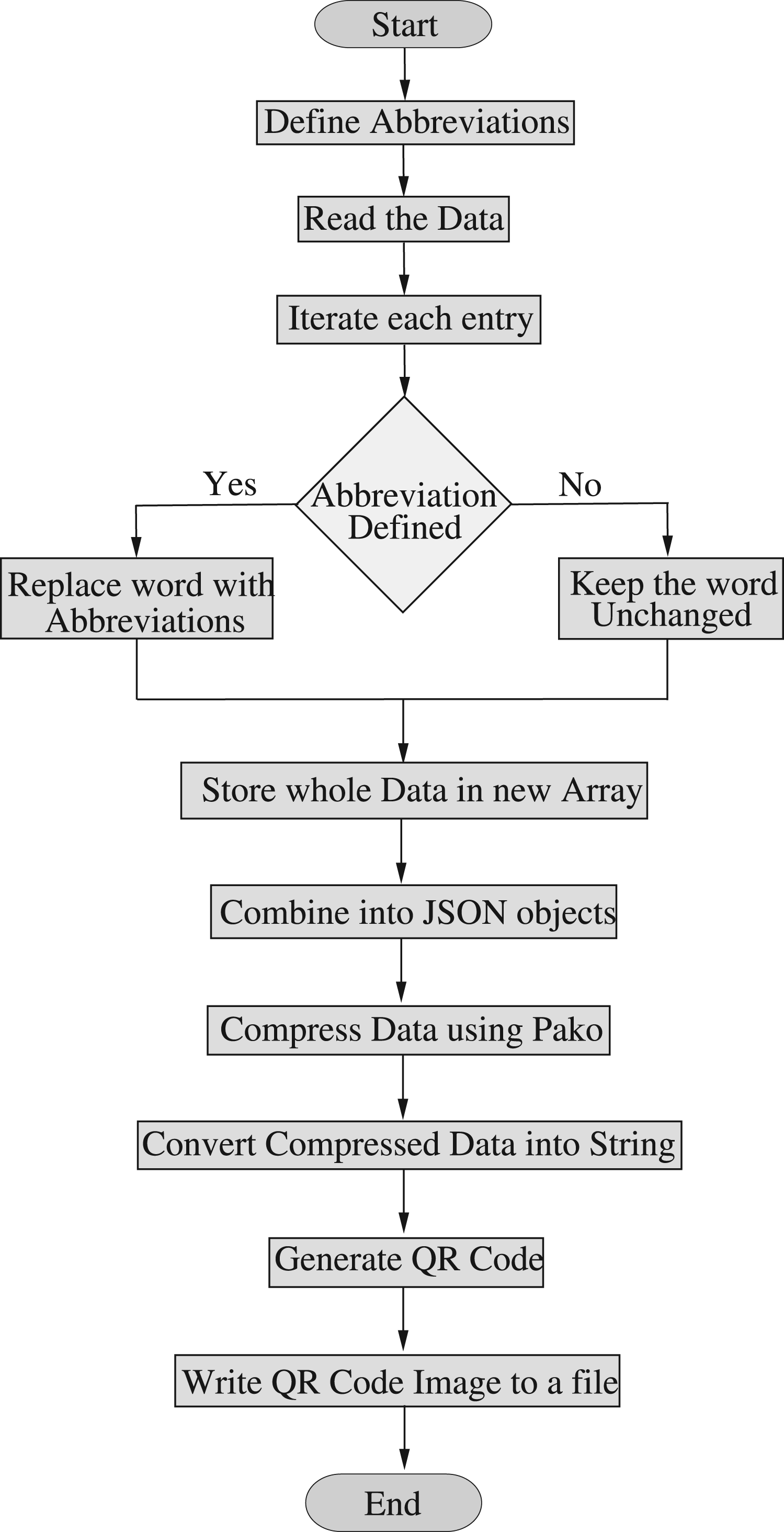
Flowchart for converting JSON data into a QR code.
When the user first opens the app on their smartphone, it requests permission to access the camera and storage. If these permissions are denied, the user must restart the app to grant access. Once permissions are granted, the user can scan QR codes. The app handles four scenarios:
Invalid QR Code: If the QR code is invalid, an alert will display “Invalid QR Code.” No QR Code Scanned: If the user attempts to access the search section without scanning a QR code, they will be unable to proceed and will receive an alert prompting them to “Scan a QR Code first.” New Valid QR Code: If the QR code is valid and has not been scanned previously, it will be processed, and the user will be redirected to the search section. Here, the user must select the current floor and destination to receive navigation instructions. Repeated QR Code: If the same QR code is scanned again, an alert will notify the user with “QR Code already scanned.”
The steps for selecting and navigating the route to the destination are illustrated in Figure 2.
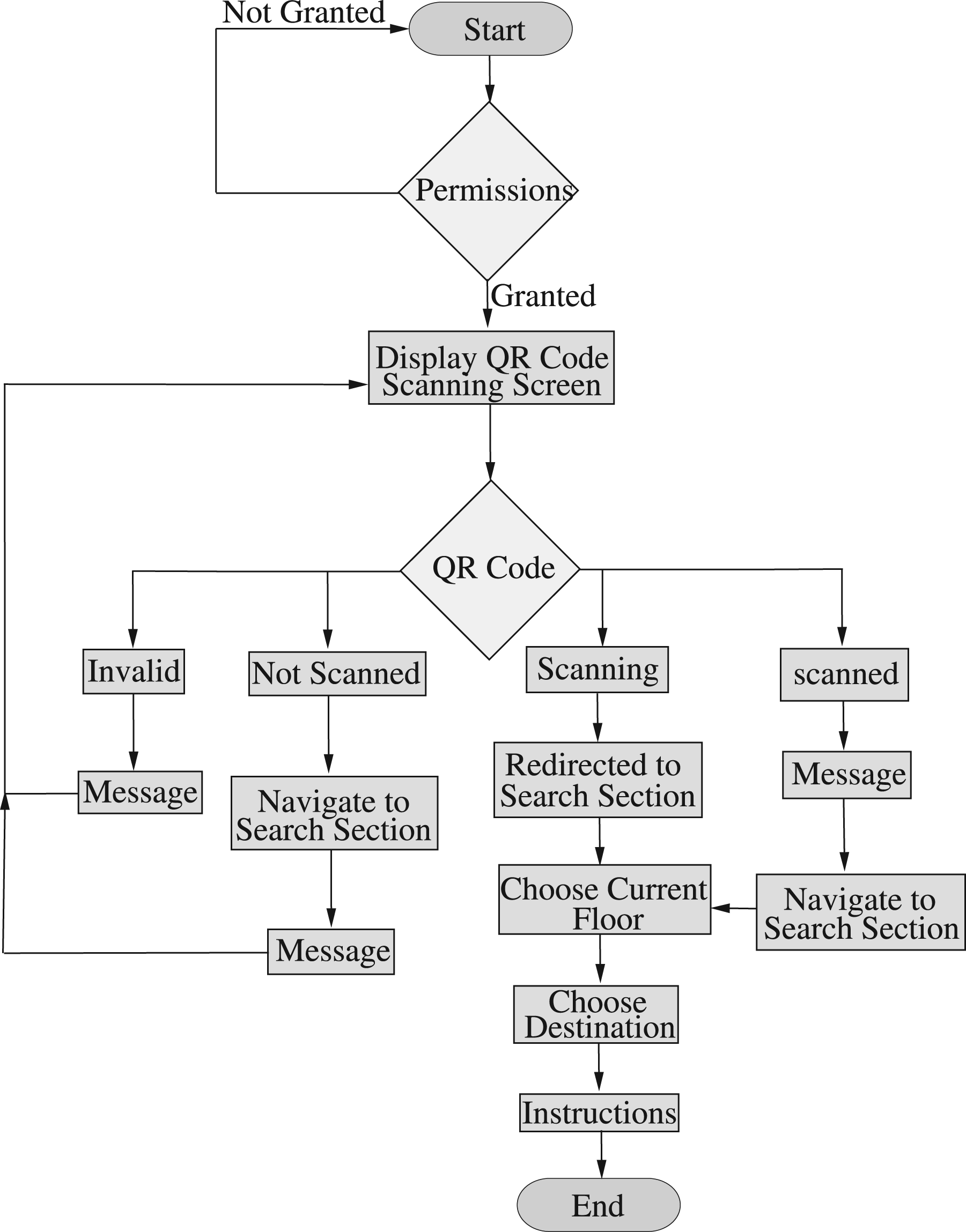
Flowchart for the app’s initial launch.
Figure 3 illustrates the flowchart for reopening the app. According to the flowchart, if the QR code has already been scanned, the app will display an alert message saying “QR Code already scanned.” In this case, the user must manually navigate to the search section to obtain the desired instructions. If the QR code has not been scanned previously, the user can scan it upon reopening the app. After scanning, the user will be redirected to the search section, where they need to select the current floor and destination to receive navigation instructions.
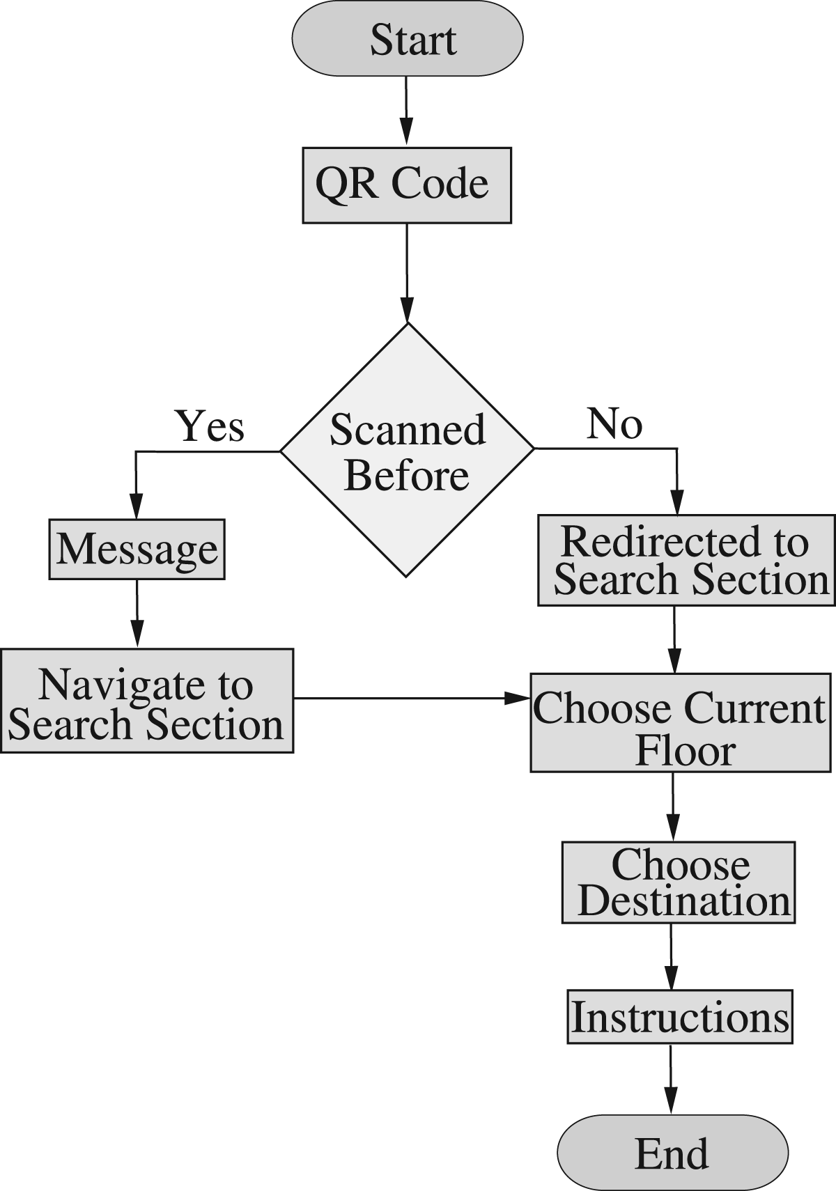
Flowchart illustrating the steps involved in reopening the application.
The step-by-step process for data decompression is illustrated in Figure 4. This flowchart outlines a function in the code responsible for handling QR code scans. If the QR code has been scanned previously, the function will terminate to prevent data from being overwritten or duplicated. If the QR code has not been scanned before, the function proceeds with the following steps: First, the scanned data is converted to a byte array and then the byte array is decompressed using the Pako library. The decompressed data is then parsed into JSON. It is checked whether the value is an abbreviation or not. If the value is not an abbreviation, then the value remains unchanged, otherwise the values are split into words. For each word, a condition is applied that looks for the abbreviation mapping and if there is an abbreviation mapping for a word it is replaced with the full form, otherwise it remains unchanged. After processing, the entire entry is returned with updated data, including the full forms, and the QR code is added to the set of scanned codes. For example, if users select the current floor as the second floor and room number 505, the app will determine if an elevator is needed based on the floor difference. Since the current floor is the second and the destination is the fifth, the first instruction will be to take the elevator to the fifth floor. Subsequent instructions will follow accordingly. When a user selects an entry from the list, the app provides simple instructions and specifies the designated room number for the native person. Clicking the search bar displays a list of details, including the names and assigned room numbers of the natives. Once a selection is made, the search bar closes to reveal the designation and instructions. If the search bar is clicked again, its value is reset. The app is designed to be versatile and can be used for any building that has a QR code in the prescribed format. There is no need to develop separate apps for different buildings; instead, a QR code containing the specific data for each building is created. With this functionality, you only need the building’s data to generate the appropriate QR code, making navigation across various buildings straightforward and efficient.
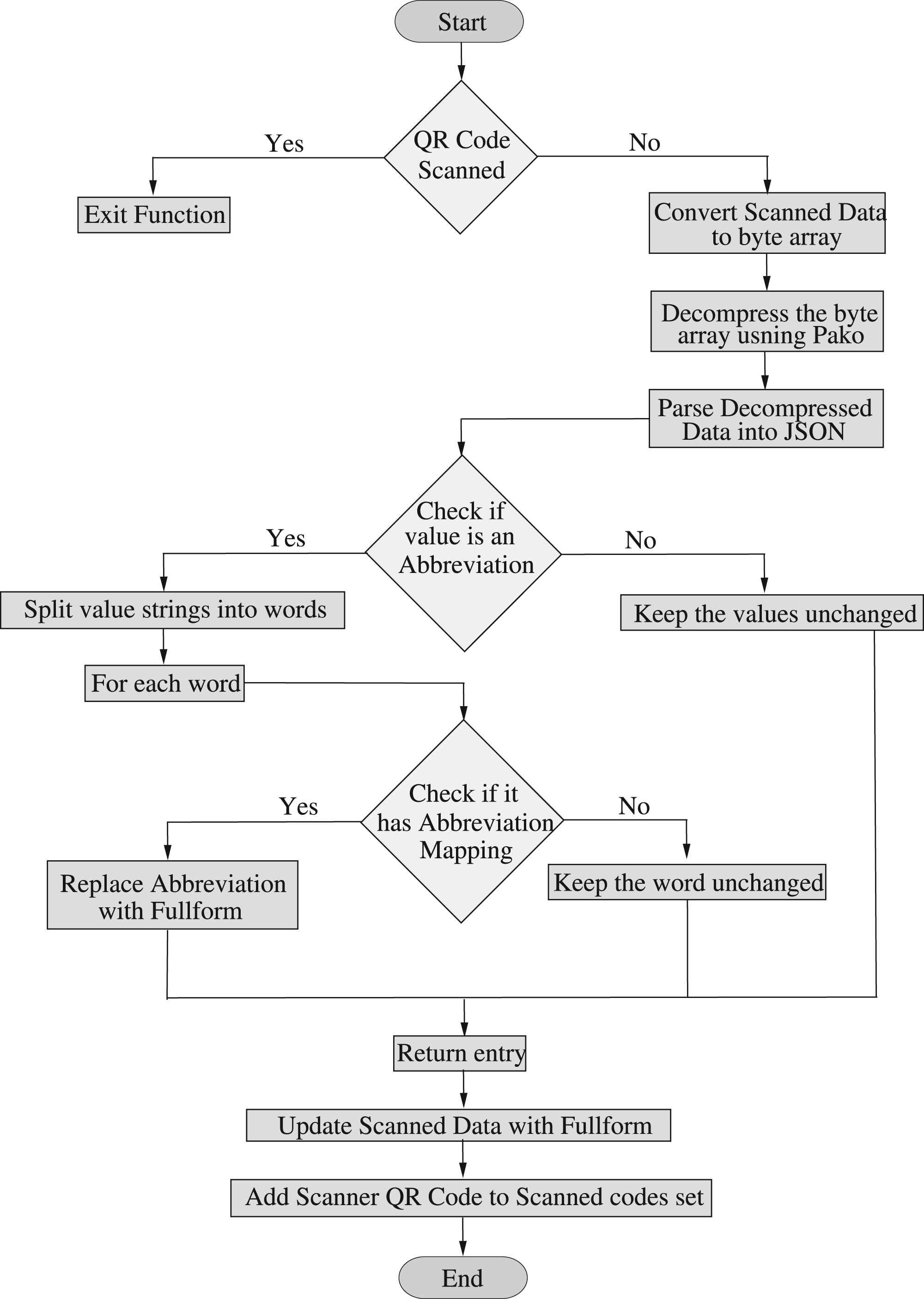
Flowchart outlining the process of data decompression.
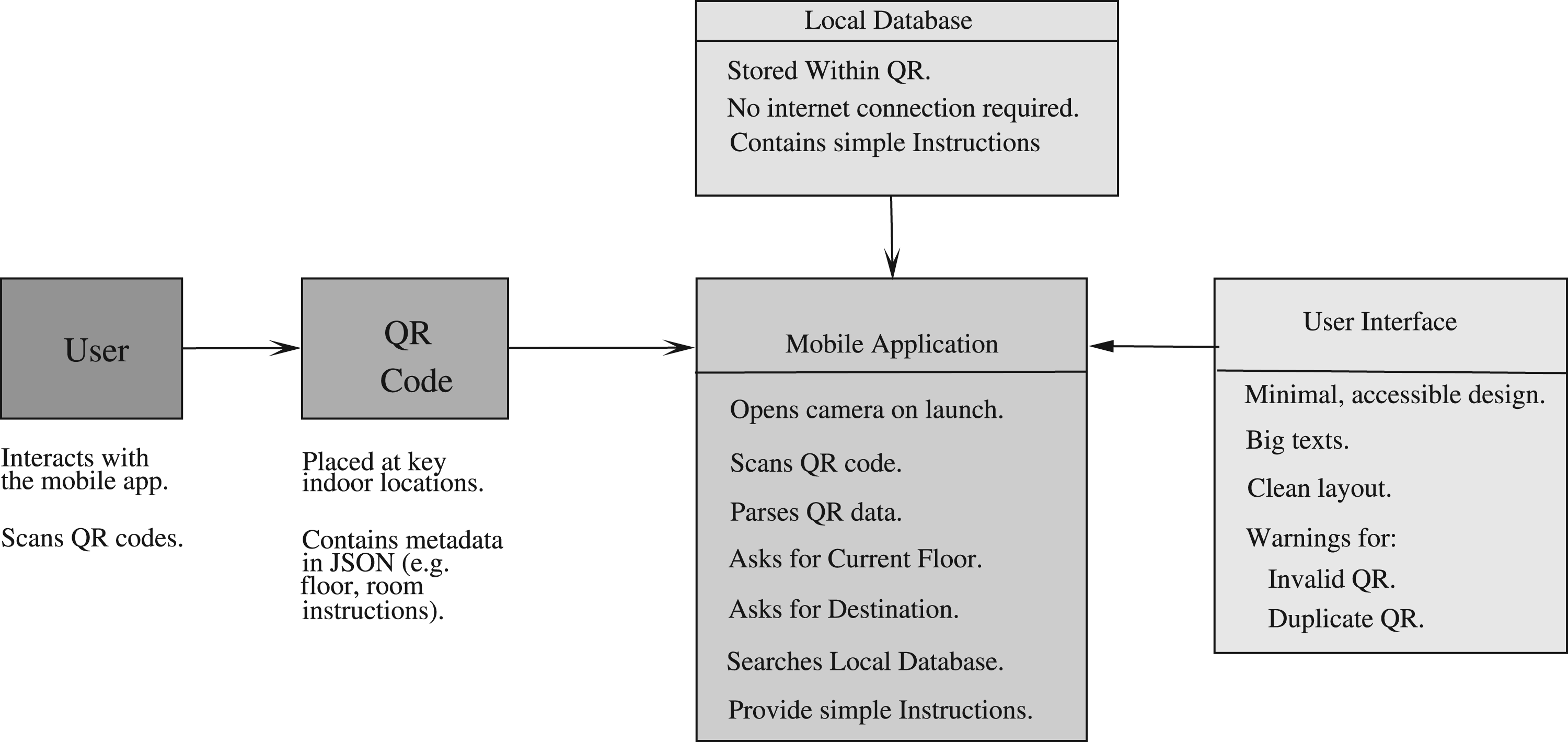
System architecture for QR-based navigation system.
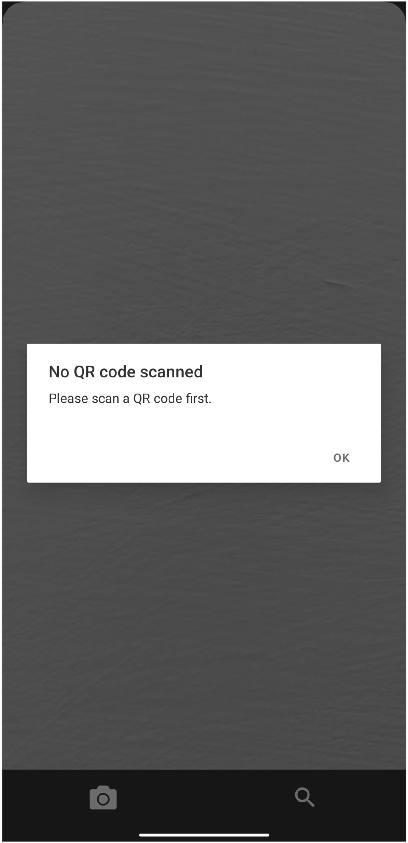
Portal to notify the user that the QR code has not been scanned.
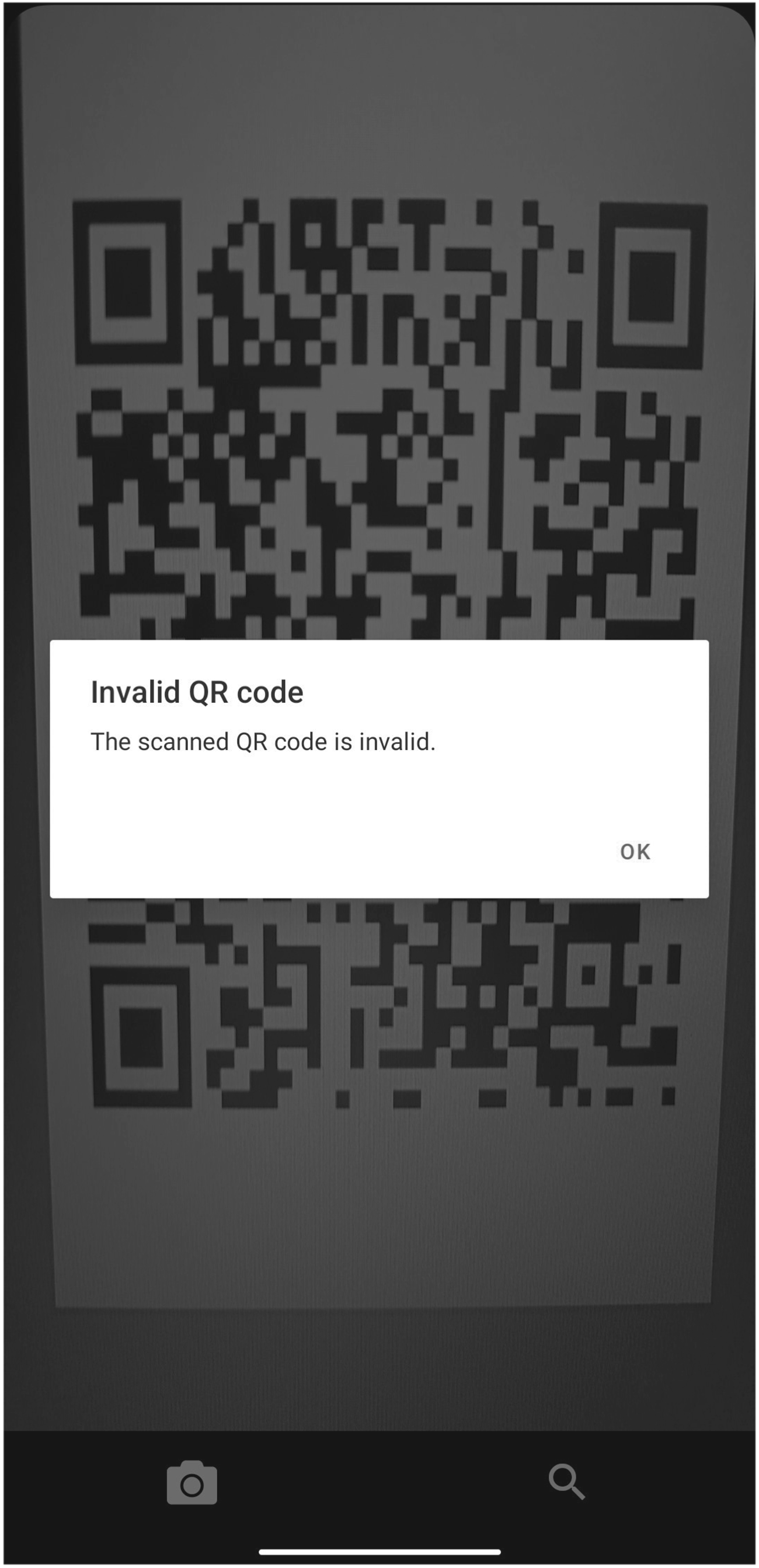
Portal to notify the user that an invalid QR code has been scanned.
For localized navigation, a smartphone is required. The app requests camera and storage permissions to scan QR codes. Local storage is used to retain scanned data, ensuring it remains accessible even after the app is closed. Storage permission is essential because, without it, all scanned data would be lost if the app were closed. By utilizing local storage, the app saves the scanned data on the phone’s memory, allowing users to recover it upon reopening the app. This ensures that building data is preserved and readily available each time the app is launched.
Working
The proposed system utilizes strategically positioned QR codes at crucial indoor points such as reception areas, elevator zones, and hallway intersections. Users interact with these codes through a dedicated mobile application. When an unrecognized QR code is scanned, the app issues an alert stating “Invalid QR code,” and if a previously scanned code is detected, it notifies the user with “QR code already scanned” to avoid redundancy. The app’s intuitive interface allows users to select their current floor and desired location with ease. Once a destination is chosen, the system delivers clear, step-by-step navigation instructions to help the user reach their endpoint effectively.
System Architecture
The proposed QR-based indoor navigation system as shown in Figure 5 is structured around three core components
Static QR Code Deployment
QR codes are installed at crucial indoor locations like entrances, reception desks, and near elevator areas where users often require guidance. Each QR code contains a JSON-formatted payload including details such as room number, faculty name, designation, floor level, and a predefined set of textual directions to the destination. These QR codes are nondynamic, any modifications necessitate regenerating and replacing them, which can be done swiftly and with minimal effort.
Cross-Platform Mobile App
Built using React Native, the mobile application is compatible with both Android and iOS devices. The app opens directly to a camera interface, requiring users to scan a QR code before accessing the navigation menu. After scanning, users select their current floor and destination through a search bar. The app then delivers straightforward, step-by-step textual guidance like “Take the first left, then an immediate right…,” following the shortest predefined route. It also supports multilevel navigation by incorporating elevator instructions when needed. The app operates entirely offline, ensuring dependable use in areas with limited or no internet connectivity.
Integrated Instruction Repository
Instead of using real-time path-finding algorithms or interactive maps, the system leverages a built-in, lightweight instruction database embedded within the app. This database contains predefined navigation routes for every possible origin-destination pair. Because all data is locally stored and fixed, the system is efficient, stable, and ideal for deployment in large indoor facilities with poor internet infrastructure or restrictive network environments.
Simulations and Results
The system does not utilize conventional training datasets, as it does not rely on machine learning techniques. Instead, the dataset comprises structured JSON data embedded within each QR code. This data includes details such as room number, room or faculty name, designation, floor information, and fixed textual navigation instructions. A single static QR code containing this metadata was placed at multiple key points across a six-story academic building. In total, around 113 unique navigation routes were defined, each reflecting the actual layout and structure of the facility. The system was tested through real-world deployment, involving 20 users who were asked to navigate the building both with and without the application. Their navigation times and feedback were recorded to assess the app’s efficiency and user experience. All data used during development and testing was based on real architectural plans—no simulated or artificial data was involved.
To simulate the proposed approach, we developed the application using React Native to ensure compatibility with both iOS and Android devices. The app offers offline functionality, allowing users to navigate within a building even without internet connectivity. Upon installation and opening of the app, users are directed to the scan section, where they must scan a QR code specific to the building. After scanning the QR code, all relevant data is stored on the user’s smartphone. If users attempt to access the search section without scanning a QR code, they will receive an alert message, as illustrated in Figure 6. If the user attempts to scan another QR code with the app, an alert message will appear stating “The scanned QR code is invalid,” as shown in Figure 7. If the QR code has already been scanned previously, an alert message indicating “QR Code already scanned” will be displayed, as depicted in Figure 8. The scanning and data decompression occur in the scan section. Once the data is decompressed, users are redirected to the search section, which features a drop-down menu for selecting the current floor, as illustrated in Figure 9. If the user tries to select a destination before choosing the current floor, an alert will prompt “Please choose your current floor first,” as shown in Figure 10. Users must first select their current floor, after which they can enter or select a room number or name using the search bar, as shown in Figure 11. The search bar filters the data based on the entered characters, displaying only those names or room numbers that match the search criteria. As characters are typed, a list of matching names or room numbers appears below the search bar, allowing users to choose from these options, as illustrated in Figure 12. Once a data item is selected from this list, the app provides straightforward instructions to reach the chosen location, as depicted in Figure 13.
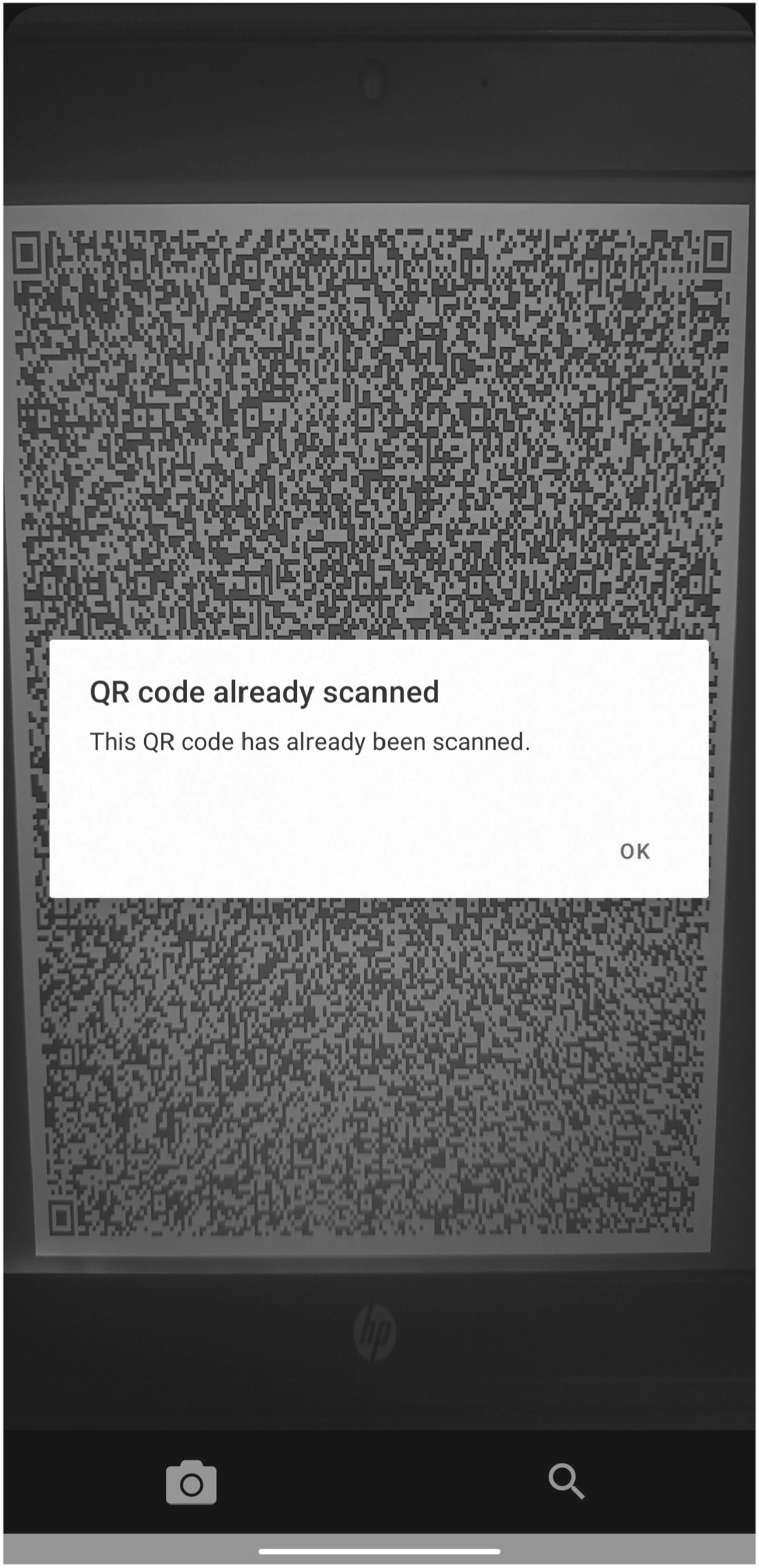
Portal to notify the user that the QR code has already been scanned.
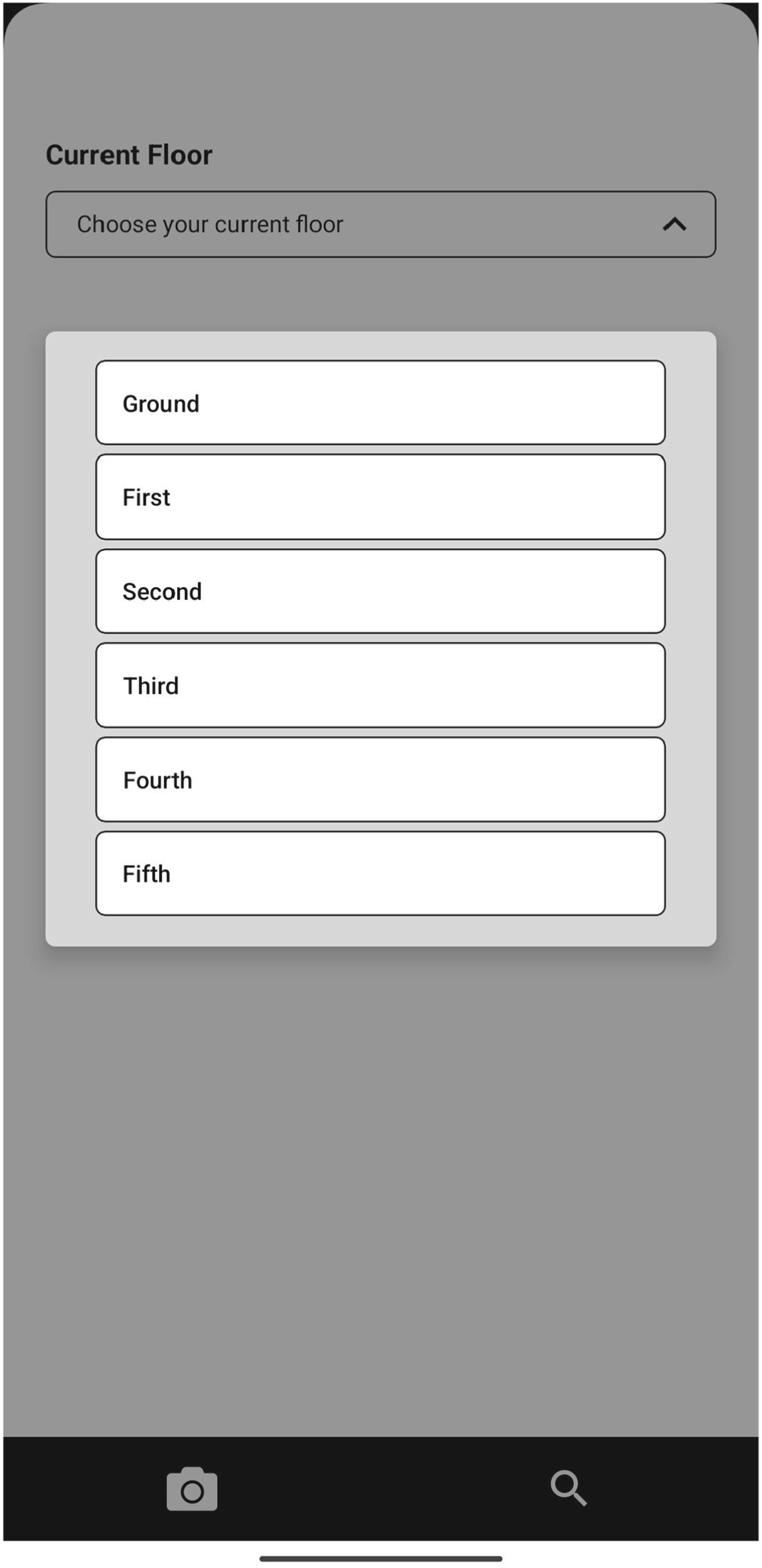
User portal to choose current location.
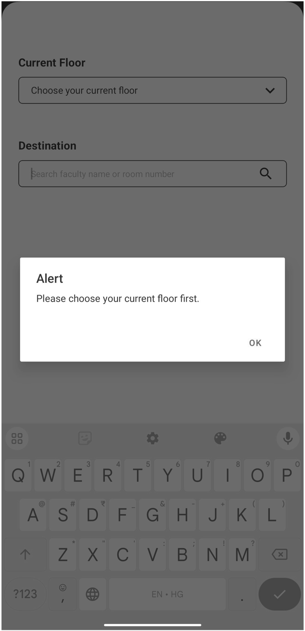
Portal to notify the user that the current floor is not chosen.
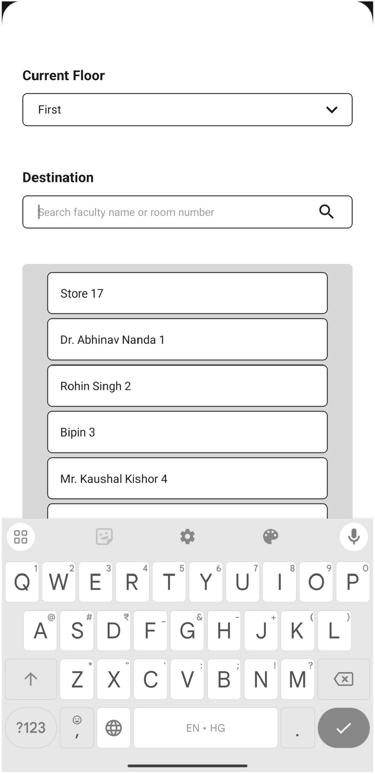
User portal to show the Destination menu.
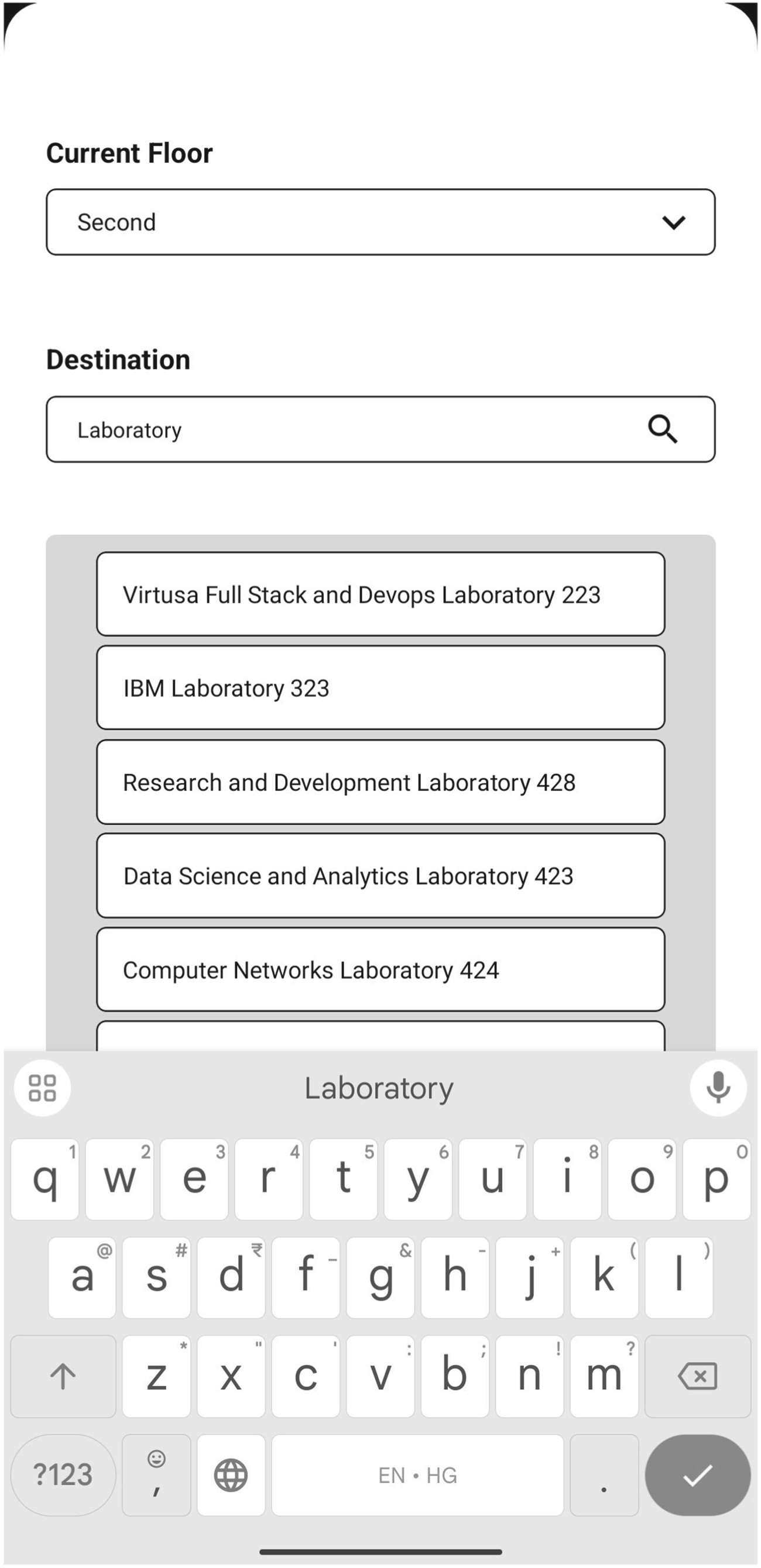
User portal to show the destination being searched.
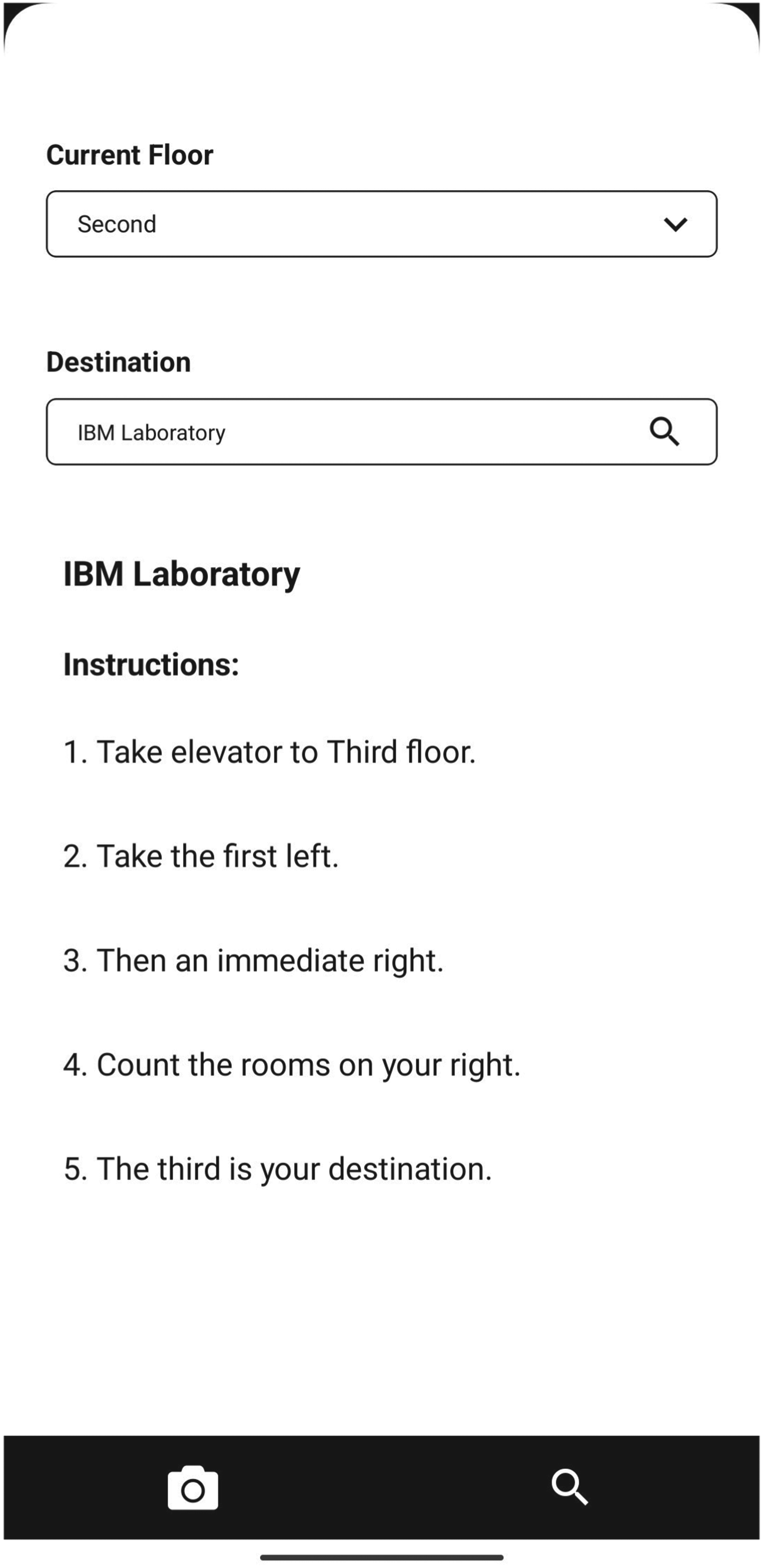
User portal to show the Instructions.
The results obtained after the simulation of the proposed approach are mentioned below.
QR Code Generation
In Figure 14, a 3D graph is shown to compare three parameters while generating a QR code. The parameters are Data Size (bytes), Compression Ratio, and Execution Time (ms). Data Size is the original size of the data. Compression Ratio is the ratio that is calculated by the division of the original data (after abbreviating) size by the compressed data size. Execution Time refers to the time consumed to generate the QR code. Data Size versus Compression Ratio represents the effect of data size on compression ratio. Compression Ratio versus Execution Time can be used to understand the relation between the efficiency of the compression and the time it takes to generate the QR code. Data Size versus Execution Time provides insights into the effect of the data size on the execution time of the QR code generation process.
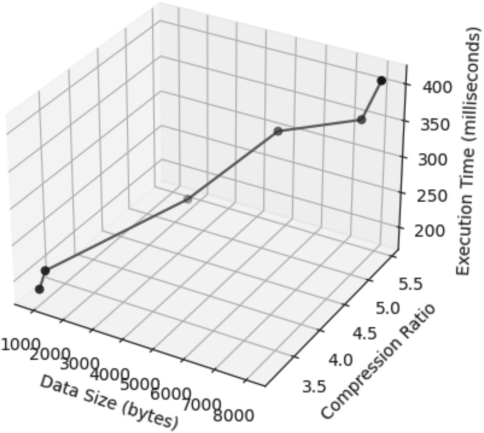
Time taken for QR code generation based upon data size and compression ratio.
Efficiency of Compression Algorithm
The efficiency of the compression algorithm is analyzed in this research, and the results obtained are represented in the graph shown in Figure 15. The two parameters considered for analysis are Data Size (bytes) and Compression Ratio. Data Size is calculated when the data is changed to the original format after removing all the abbreviations. The Compression Ratio is the ratio of original QR code data to the decompressed data size. Data Size versus Compression Ratio shows the effect of data size on the compression ratio.
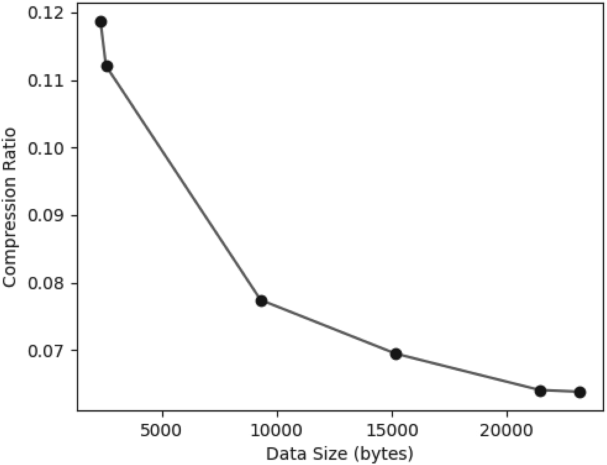
Efficiency of compression algorithm.
QR Code Scan Efficiency
The efficiency of scanning the QR code is given in the graph shown in Figure 16. Here, the parameters considered are Scanning Time (ms) and Storage Time (ms). Scanning Time is the time taken to scan the QR code. Storage Time is the time taken to write the data in the local storage. Scanning Time versus Storage Time shows the relationship between the time taken to scan a QR code and the time taken to store the scanned data.
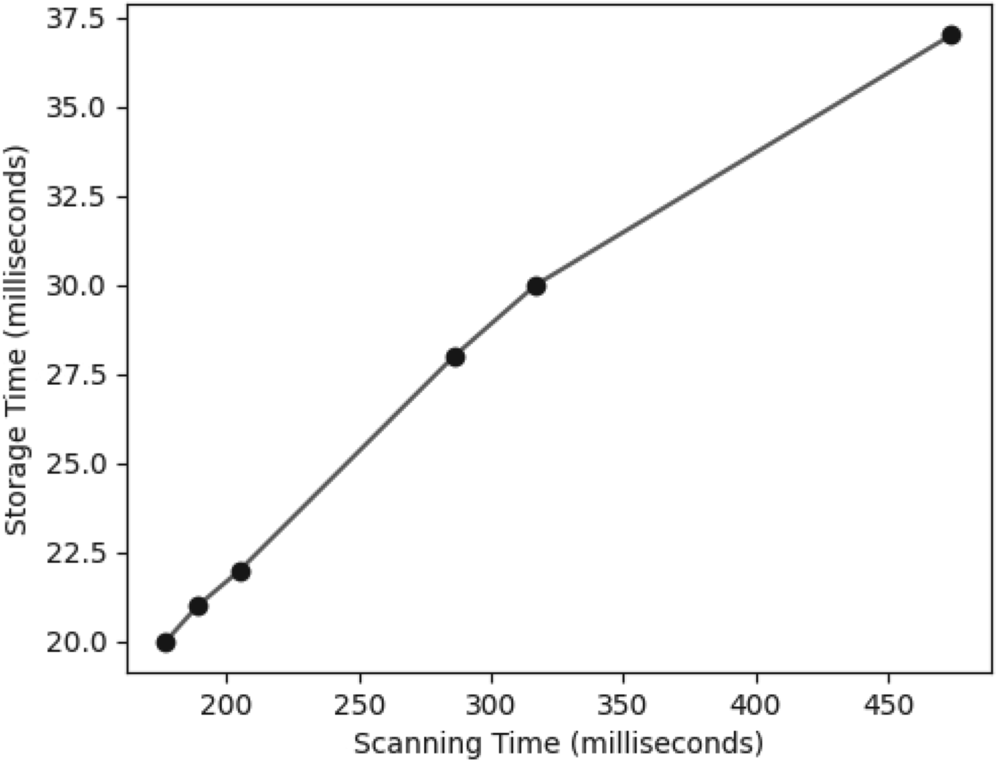
Scanning and storage efficiency analysis.
App Navigation versus Manual Navigation
A survey was conducted involving two groups of 20 users each. One group used the application to navigate through a particular building, while the other group navigated to various locations in the same building without the app. The results indicated that users with the application were able to navigate to their destinations more efficiently than those without it. The graph in Figure 17 compares the time (min), distance (m), and accuracy of arriving at the destination using the proposed application. The graph in Figure 18 compares the same parameters for the users who didn’t use the app to reach the desired destination in the same building. There is a significant difference in time and accuracy for reaching the same destination. Here, time represents the complete duration required for an individual to reach their destination, distance is the distance traveled by them while reaching their destination, and accuracy is the measure of distance traveled before reaching the destination.
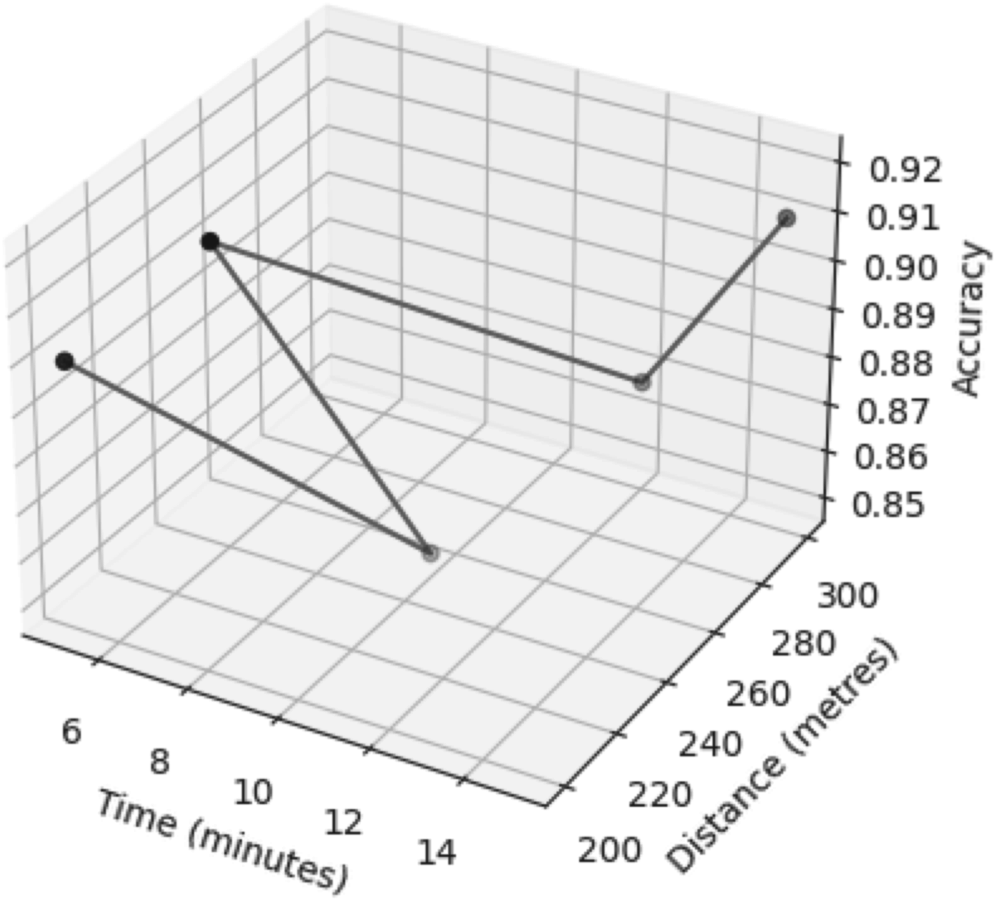
Accuracy based upon time and distance when the app is used.
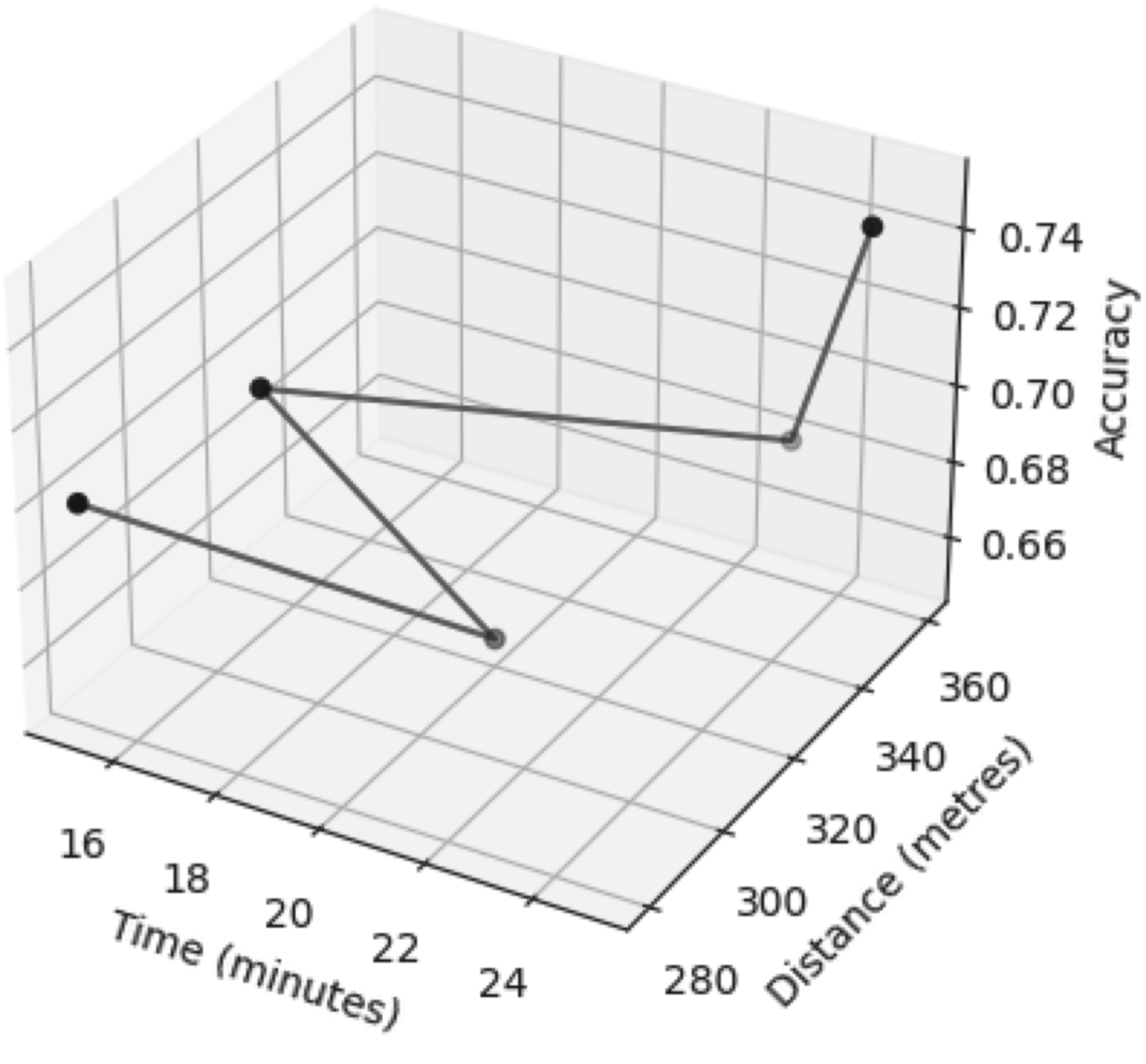
Accuracy based upon time and distance when navigated without the app.
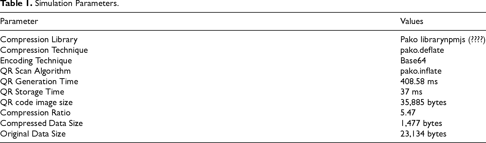
Table 1 shows all the necessary parameters that are used in the research process.
Simulation Parameters.
The system was evaluated using both a smartphone and a laptop. Mobile testing was carried out on a Redmi Note 9, featuring a MediaTek Helio G85 chipset, 4 GB of RAM, 64 GB of storage, and a 6.53-inch screen. QR code scanning was performed via the device’s rear camera, while the navigation application was built using React Native, offering seamless offline functionality and broad Android compatibility. For development and simulation purposes, a Windows 10 Pro 64-bit laptop was utilized. The device used was an HP ProBook 430 G3, equipped with an Intel Core i5-6200U @ 2.30 GHz processor, 8 GB RAM, and Intel HD Graphics 520 integrated graphics.
Use Cases
The proposed QR-based system is ideally suited for complex indoor spaces such as hospitals, shopping malls, airports, university campuses, and other large-scale facilities where finding one’s way can be difficult. These places often have intricate structures, including rooms within rooms, multiple floors, and interconnected hallways, which can easily disorient visitors. Take, for example, a multispecialty hospital like AIIMS Delhi, where patients and guests often struggle to locate departments spread across numerous buildings and floors. In such scenarios, the QR-guided navigation system offers clear, step-by-step instructions from the main reception to specific areas like radiology, cardiology, or the pharmacy, enhancing overall convenience and efficiency. Likewise, in expansive shopping centers such as Select Citywalk in New Delhi, visitors frequently find it difficult to navigate through numerous shops, dining areas, and facilities spread across multiple levels. A QR-based navigation system can simplify this process by offering clear, step-by-step instructions from the point of entry to the desired destination, enhancing both convenience and overall user satisfaction.
Performance Evaluation
User Study and Experimental Setup
We carried out a user study with 20 participants to assess the performance of our QR-based indoor navigation app. Half of the participants navigated to a target location using the app, while the other half relied on traditional human guidance (asking a receptionist or passerby). Each participant completed a single navigation task.
Navigation Using the App
Participants installed the QR-based app, scanned a QR code at the starting point, and selected their current location and destination. The app then provided simple step-by-step textual directions, which the users followed to reach the target location.
Navigation Using Human Guidance
Participants were instructed to ask a receptionist or a passerby for directions to the target location and then follow the guidance they received. This method represents a traditional, low-cost approach to indoor navigation.
Measures and Calculations
The following metrics were used to evaluate performance: 




Measurement Validity
The performance metrics used in this study—Task Completion Rate (TCR), Time to Destination (TTD), Endpoint Error (EE), User Effort (UE), and Wrong Turns (WT)—were chosen for their relevance in assessing navigation efficiency and user interaction. These metrics were inspired by commonly used approaches in usability and navigation evaluation.
All measurements are objective in nature. Time-based metrics such as TTD were recorded using consistent start and end points, while spatial accuracy (EE) was determined based on predefined target locations. Interaction-based metrics, including UE and WT, were documented through observable user behavior during the navigation process.
To ensure reliability, all participants completed tasks under similar environmental conditions, and a standardized procedure was followed for data collection across all trials. Although a formal, validated questionnaire was not used, the selected metrics offer a practical and reasonably reliable framework for evaluating system performance.
Control of Confounding Variables
The experimental design was structured to reduce the impact of potential confounding variables that could influence navigation performance. All participants completed the tasks within the same indoor setting, with identical starting points and destination targets to maintain consistency.
To further limit variability arising from external factors, the experiments were carried out under similar environmental conditions, including consistent time periods and comparable crowd levels. Participants were also given standardized instructions beforehand to ensure a uniform understanding of the task.
Moreover, efforts were taken to ensure that participants were not previously familiar with the navigation routes used in the study. Although individual differences such as walking speed and level of comfort with smartphone usage may still exist, their overall effect was minimized due to the controlled and consistent conditions maintained throughout the experiment.
Results
With App
Task completion rate 92%, average time 420 s (approx. 7 min), average endpoint error 45 m, minimal user effort (1 scan), and few wrong turns.
Without App
Task completion rate 85%, average time 600 s (approx. 10 min), average endpoint error 48 m, higher user effort (2–3 questions on average), and more wrong turns.
To further evaluate the effectiveness of the proposed QR-based indoor navigation system, a comparative analysis was conducted between two participant groups—one using the app and the other navigating without it. Each group consisted of 10 users who performed identical navigation tasks within the same building. The app users achieved a 92% task completion rate, while the nonapp group achieved 85%. The average time to reach the destination was significantly shorter for the app group (mean = 420 s) compared to the nonapp group (mean = 600 s), highlighting improved navigation efficiency. The observed average endpoint error of approximately 45 m supports the system’s accuracy in guiding users without relying on complex localization algorithms. Participants using the app required minimal effort, completing navigation with a single QR scan, whereas nonapp users asked two to three clarifying questions on average and made more navigation errors. The observed results indicate noticeable differences in navigation time, effort, and number of wrong turns between the two approaches. Overall, these findings demonstrate that the QR-based system delivers faster navigation, higher accuracy, reduced user effort, and enhanced reliability, making it a practical and cost-effective solution for indoor navigation compared to traditional human-guided approaches. The analysis is based on descriptive observations due to the limited sample size.
The results are presented through descriptive comparisons between the participant groups. The observations suggest improved navigation performance with the proposed system, reflected in reduced completion time, lower user effort, and fewer navigation errors such as wrong turns.
However, due to the relatively small sample size, no formal inferential statistical analysis was carried out. Consequently, metrics such as effect sizes and confidence intervals are not included, and the results should be viewed as indicative patterns rather than conclusive statistical evidence. Future research with a larger and more diverse set of participants can incorporate appropriate statistical methods, including effect size measurement and confidence interval estimation, to strengthen the validity of these findings.
Conclusions
This research has examined various methods of indoor navigation across different technologies and analyzed their associated complexities. Previous approaches often fell short in key areas such as cost, maintenance, accuracy, and precision, failing to deliver comprehensive and reliable indoor navigation solutions. Our findings indicate that existing research does not provide a fully integrated solution. The ideal indoor navigation system should meet the following criteria: it must be straightforward to implement, cost-effective, capable of enhancing user independence and mobility, and readily accessible to everyone. Our research focused on developing a cost-effective navigation method that requires no additional hardware. We achieved this by using QR codes to store data and incorporating encoding techniques along with a compression algorithm. Generating the QR code with JSON data takes approximately 408.58 ms. Initially, the data size was 23,134 bytes, but after compression, it was reduced to 1,477 bytes. Scanning the QR code through the app takes 474 ms, while storing the data in local storage takes 37 ms. Looking ahead, the field of indoor navigation presents numerous opportunities for further research and development. As technology advances and our understanding of indoor environments deepens, we can expect the development of more advanced and reliable indoor navigation systems in the near future. These systems have the potential to transform indoor navigation, offering new opportunities for interaction, engagement, and efficiency within these environments. While achieving perfect indoor navigation presents numerous challenges, it is an exciting and promising journey. This research marks a modest step toward that goal. We hope that the findings and discussions presented in this paper will inspire further investigation and breakthroughs in this fascinating field. As we advance the boundaries of indoor navigation technology, we eagerly anticipate the innovative opportunities that will emerge. In future implementations, the system could be enhanced by embedding floor or zone identifiers directly within each QR code. This would enable the mobile application to automatically determine the user’s current location upon scanning, eliminating the need for manual input. The result would be a more streamlined and intuitive user experience, all while maintaining full offline functionality. For added flexibility, users could still have the option to manually confirm or adjust their location. As all routing logic and data would be stored locally within the app, this approach remains entirely feasible without the need for internet connectivity.
Footnotes
Acknowledgments
We would like to show sincere appreciation to our colleagues Mr. Amol Chitale (School of Computing, DIT University) and Mr. Sandeep Chauhan (School of Computing, DIT University) for their support and assistance during this research work.

Funding
The authors received no financial support for the research, authorship, and/or publication of this article.
Declaration of Conflicting Interests
The authors declared no potential conflicts of interest with respect to the research, authorship, and/or publication of this article.
Data Availability Statement
Data sharing is not applicable to this article as no new data were created or analyzed in this study.