
Abstract
The growing demand for reliable, low-carbon energy in the Southern African Power Pool (SAPP) necessitates a harmonized, region-wide approach to hydropower development in the SAPP. While GIS–MCDA and AHP methods have been widely applied at basin or national scales, this study uniquely presents a comprehensive geospatial analysis by integrating multiple spatial datasets across all 12 SAPP member states: Angola, Botswana, Democratic Republic of the Congo (DRC), Eswatini, Lesotho, Malawi, Mozambique, Namibia, South Africa, Tanzania, Zambia, and Zimbabwe. This study advances existing research by applying a standardized GIS–MCDA–AHP framework consistently across diverse countries, incorporating underutilized criteria such as the Standardized Precipitation Index (SPI) and detailed geological and soil texture layers, and integrating environmental and land-use constraints through Boolean masking. The resulting Hydropower Suitability Index identifies spatially coherent, high-potential hydropower corridors along major river systems, including the Congo, Zambezi, Cuanza, and Limpopo basins. Validation with existing hydropower stations and a sensitivity analysis confirmed the robustness of the model. The findings provide policy-relevant insights that support cross-border energy planning, sustainable regional energy expansion, and enhanced climate resilience in Southern Africa, offering practical guidance to policymakers and planners.
Keywords
Introduction
Hydropower remains a cornerstone of renewable energy strategies worldwide because of its reliability, vast resource potential, and low carbon footprint. In the Southern African Power Pool (SAPP), which is composed of 12 diverse member countries, harnessing this resource effectively is critical to meeting growing electricity demands, enhancing regional energy security, and mitigating climate change impacts. Although numerous studies have applied Geographic Information Systems (GIS), Multi-Criteria Decision Analysis (MCDA), and the Analytic Hierarchy Process (AHP) for hydropower siting at basin or national scales, these efforts have often been fragmented and limited in geographic scope.
This study addresses a significant research gap by providing the first harmonized regional-scale geospatial assessment of hydropower suitability across the entire SAPP region. Unlike prior models that focus on single countries or isolated basins, this study integrates multi-country spatial datasets using a consistent GIS–MCDA–AHP framework. Methodological novelties include the incorporation of underutilized criteria, such as the Standardized Precipitation Index (SPI) and detailed geological and soil texture information, alongside environmental and land-use constraints applied through Boolean masking. This integrated approach enables the identification of hydropower potential zones that are not only technically feasible, but also environmentally and socially responsible.
The primary research question guiding this study is as follows: Where are the optimal sites for sustainable hydropower development across the SAPP region when considering hydrological, geological, environmental, and socio-technical constraints? By answering this question, this study aims to fill critical knowledge gaps in regional energy planning, offering a scalable and reproducible framework that supports cross-border cooperation and policy formulation.
The key contributions of this study are as follows:
A unified, harmonized assessment of hydropower suitability across all 12 SAPP member states, overcoming previous geographic fragmentation, is required. The integration of novel spatial criteria, such as the SPI and soil texture, enhances the robustness of suitability modeling. The application of environmental and land-use exclusion masks ensures sustainable and socially responsible site selection. This study provides actionable insights for policymakers and planners to facilitate coordinated, climate-resilient, and sustainable hydropower development in Southern Africa.
To strengthen the scientific foundation, recent advances in socioeconomic vulnerability and environmental impact assessments have been incorporated, reflecting the latest research trends and contextualizing hydropower planning within broader sustainability goals. (Bhowmik, Kader & Hosen, 2025)
This introduction sets the stage for a comprehensive geospatial analysis that bridges the methodological gaps and supports practical energy planning needs in the Southern African Power Pool region.
Literature review
This literature review synthesizes key themes relevant to hydropower siting suitability in Southern Africa, focusing on criteria selection, MCDA methodologies, validation approaches, and regional hydropower planning, while explicitly linking prior studies to the methodological choices in this study.
Criteria selection for hydropower suitability
Hydropower siting depends critically on several geospatial and environmental factors. Previous studies consistently emphasize the importance of topographical variables such as slope and elevation, hydrological factors including drainage density and flow accumulation, and geological stability for infrastructure feasibility (Ballance, Stephenson, Chapman & Muller, 2000; Kaunda, Cuthbert & Torbjorn, 2012).Land cover and environmental constraints are also crucial to minimize ecological and social impacts (Corbett, 1999; Klunne W. J., Small hydropower in southern Africa – an overview of five countries in the region, 2013). Climatic indicators such as rainfall and drought indices like the Standardized Precipitation Index (SPI) have been underutilized but are essential for assessing water availability and hydropower reliability (Kachaji, Kasulo & Chavula, 2016; Lucy, Bronstert, Shrestha, Kadewere & Vormoor, 2020). Soil texture influences foundation stability and water retention, affecting dam construction feasibility (Miguel M., Juízo, & Kenneth, Hydro Power Potential in Mozambique “CHUA- MANICA”, 2015).; (Mwendera, 2006).
The selection criteria of slope, elevation, drainage density, flow accumulation, geology, land cover, rainfall, SPI, and soil texture reflect these established factors. The inclusion of SPI and detailed soil texture layers is based on emerging research highlighting their significance for climate resilience and infrastructure stability (Bhowmik et al., 2025; Miguel M., Juízo, & Kenneth, Hydro Power Potential in Mozambique “CHUA- MANICA”, 2015).
MCDA methodologies and weight assignment
Geospatial Multi-Criteria Decision Analysis (MCDA), often integrated with GIS, is widely adopted for hydropower suitability assessments because of its capacity to handle heterogeneous spatial data and incorporate expert judgment (Fatima-zahra, Jbaihi, Alami, Merrouni & Maaroufi, 2022; Eshra, Ahmed & Shady, 2021).The Analytic Hierarchy Process (AHP) is the most common weighting technique, offering a systematic framework to derive criteria weights through pairwise comparisons grounded in domain knowledge and literature (Klunne W. J., Small hydropower in southern Africa – an overview of five countries in the region, 2013; Kusre, Baruah, Bordoloi & Patra, 2010).
Prior studies justify weight assignments based on hydropower siting logic: slope and flow accumulation typically receive higher weights due to their direct influence on hydraulic head and water availability, while environmental constraints are treated as exclusion masks rather than weighted criteria (Bekker, Dijk M. & Niebuhr, 2022; Denisov and Denisova, 2017). Sensitivity analyses of similar MCDA frameworks confirmed that moderate weight variations did not substantially alter suitability outcomes, underscoring model robustness (Masahiko et al., 2017; Thomas, Kendra & Hill, 2016).
The AHP weight matrix and consistency checks of this study align with these precedents, ensuring methodological rigor and transparency. Weight ranges and thresholds are informed by hydropower engineering principles and regional environmental considerations documented in the literature (Kichonge, 2018; Mwendera, 2006).
Validation approaches
Validation of hydropower suitability models typically involves overlaying predicted high-potential sites with existing hydropower infrastructure to assess spatial agreement (Ranjit, Mileva & Grace, 2018; Shafiullah et al., 2021). Sensitivity analyses, varying criteria weights by ±10–20%, test model stability and identify dominant factors (Fatima-zahra et al., 2022; Kusre et al., 2010).
These approaches ensure that the models are both accurate and reliable for planning applications.
This study adopts similar validation strategies, confirming the model's alignment with known hydropower stations and demonstrating its robustness through sensitivity testing.
Hydropower planning in African context
Hydropower development in Africa faces unique challenges, including fragmented national studies, limited cross-border coordination, and environmental-social trade-offs (Gnassou, 2019; Taliotis, Bazilian, Welsch, Gielen & Howells, 2014). Regional-scale assessments are scarce but critical for integrated planning within power pools, such as the SAPP (Kaunda et al., 2012; Kichonge, 2018). Small hydropower and run-of-river projects are increasingly recognized for their potential in rural electrification and climate adaptation (Klunne W. J., Small hydropower in southern Africa – an overview of five countries in the region, 2013; Helene and Sjöstedt, 2015).
This study contributes to filling the regional-scale assessment gap by harmonizing multi-country datasets and integrating underutilized criteria to support sustainable cross-border hydropower planning in SAPP, thus advancing both scientific understanding and policy relevance.
Methodology
Overview
This study applied a GIS-Based Multi-Criteria Evaluation (MCE) integrated with the Weighted Linear Combination (WLC) method to assess hydropower siting suitability within the Southern African Power Pool (SAPP). The analysis used nine spatial factors known to influence hydropower potential: drainage density, elevation, flow accumulation, geological conditions, land cover, rainfall distribution, slope gradient, and Standardized Precipitation Index (SPI). Environmental and planning constraints (protected areas, wetlands, and built-up areas) were incorporated as Boolean exclusion masks.
Data collection and preparation
Spatial datasets were sourced from global and regional sources, including the SRTM DEM, HydroSHEDS, WDPA, ESA Land Cover, and national geological maps. All layers were reprojected to a common coordinate system and resampled to achieve a uniform spatial resolution.
DEM-derived variables
Other factors
The SPI layers were generated from long-term rainfall datasets.
The geological units were reclassified according to their suitability for hydropower foundation conditions.
The land cover and rainfall distribution were extracted and converted into raster suitability layers.
Standardized precipitation Index (SPI) calculation
The Standardized Precipitation Index (SPI) was computed to evaluate precipitation variability and drought conditions affecting hydropower suitability across the Southern African Power Pool (SAPP) region. A 12-month SPI time scale was selected to capture long-term precipitation anomalies relevant to annual water availability critical for hydropower generation.
Monthly precipitation data covering the period 1990–2020 were sourced from a combination of satellite-derived products and ground-based meteorological stations to ensure comprehensive spatial and temporal coverage across all SAPP member countries. The datasets underwent quality control and homogenization prior to analysis.
SPI calculation followed the standard approach described by McKee et al. (1993), involving fitting a gamma probability distribution to precipitation data and transforming the cumulative probabilities into a standard normal distribution. This normalization enables consistent comparison of drought and wetness conditions across diverse climatic zones within the study area.
The resulting SPI raster was classified using widely accepted climatological thresholds:
SPI ≤ −2.0: Extremely dry SPI −1.5 to −1.99: Severely dry SPI −1.0 to −1.49: Moderately dry SPI −0.99 to 0.99: Near normal SPI 1.0 to 1.49: Moderately wet SPI 1.5 to 1.99: Severely wet SPI ≥ 2.0: Extremely wet
This classification facilitates hydrological interpretation and identification of regions with varying precipitation reliability.
Within the Multi-Criteria Decision Analysis (MCDA) framework, SPI was assigned an appropriate weight reflecting its significance in representing hydrological reliability and climate variability. Incorporating SPI enhances the robustness of hydropower suitability modeling by highlighting areas less vulnerable to drought stress, thereby supporting sustainable site selection.
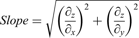
Factor standardization
All criteria were standardized to a
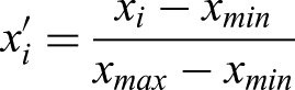
For criteria negatively related to suitability (e.g., extremely steep slopes and unsuitable geology), reverse normalization was applied as follows:
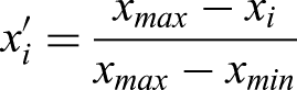
This ensured comparability across all the factor layers.
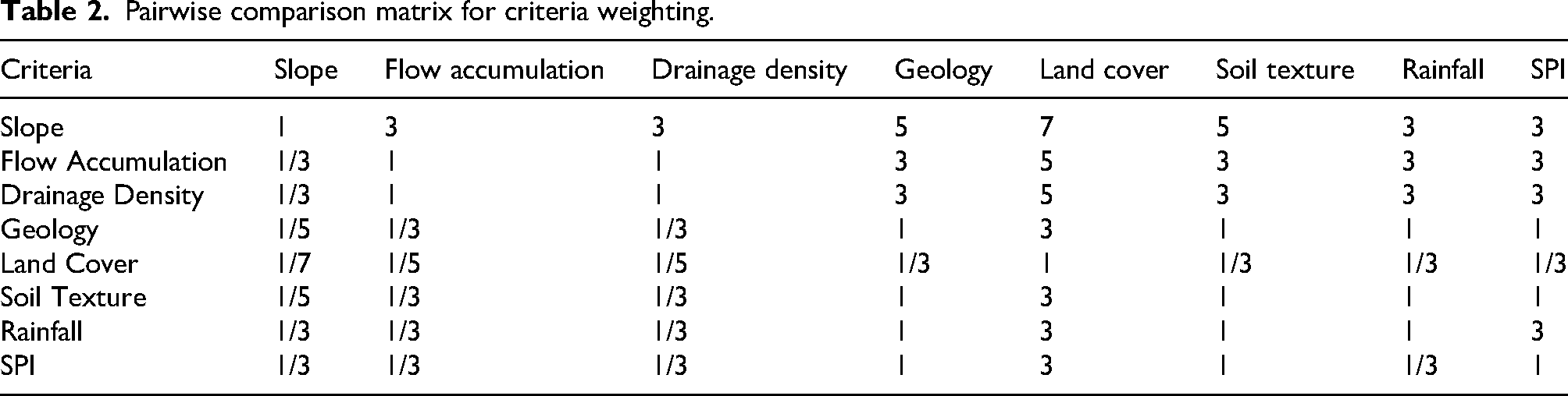
Criteria weighting using AHP
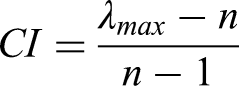
The weights for each factor were determined using the
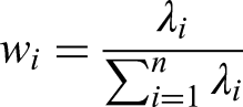
The consistency of the matrix was evaluated using the
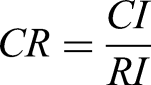
A CR < 0.10 indicates acceptable consistency.
Pairwise comparison matrix for criteria weighting (AHP)
Weights Derived from the Eigenvector Method:
Consistency ratio (cr) reporting
Calculated Consistency Index (CI): 0.07
Random Index (RI) for n = 8 criteria: 1.41
Consistency Ratio (CR) =
The criteria weights were derived through a structured Analytic Hierarchy Process (AHP) based on expert judgment and a literature review. The expert panel comprised five professionals specializing in hydropower engineering, GIS spatial analysis, environmental planning, and regional energy policy, affiliated with academic institutions and renewable energy consultancies. Experts provided pairwise comparisons independently, which were aggregated using the geometric mean method to form a consensus matrix. The AHP method was selected for its systematic approach to integrating expert knowledge and its capacity for consistency checking, making it widely accepted in hydropower suitability studies.
Justification for AHP selection:
AHP was chosen over alternative MCDA methods, such as TOPSIS and PROMETHEE, because of its hierarchical structuring ability, transparent weighting process, and robustness in handling qualitative and quantitative criteria. Its consistency ratio metric ensures reliable expert input, which is critical for multi-criteria spatial decision-making in hydropower-site selection.
The lower weight assigned to the Standardized Precipitation Index reflects its role as a secondary climatic reliability factor rather than a primary physical constraint. While SPI is critical for assessing long-term hydrological stability and climate resilience, topographic variables like slope and flow accumulation are the primary determinants of the physical feasibility and hydraulic head required for hydropower generation. (Eshra, Zobaa & Aleem, 2021; Ouchani, Jbaihi, Merrouni, Ghennioui & Maaroufi, 2022)
WLC-Based suitability modeling
The standardized criteria and their AHP-derived weights were integrated using the
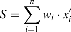
Where:(S) = overall suitability index,s(
This approach allows the factors to trade off and reflects the relative contribution of each criterion to hydropower feasibility.
Integration of constraints (boolean masking)
Environmental and land use constraints were included as binary layers (
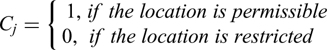
An overall constraint mask was produced as follows:
The final suitability output was as follows:

Thus, any restricted area automatically received a suitability value of zero.
Classification and extraction of candidate sites
The final suitability index
The classified output was overlaid with the stream network derived from flow accumulation to extract
Validation and sensitivity analysis
The model performance was evaluated by overlaying existing hydropower stations within SAPP to assess whether they fell within the predicted high-suitability zones. Sensitivity analysis was conducted by varying the factor weights (±10–20%) and observing changes in the spatial distribution of the suitability classes.
The ±10–20% variation in criteria weights aligns with common practice in MCDA studies, reflecting realistic uncertainty bounds in expert judgment and data variability (Fatima-zahra et al., 2022; Kusre et al., 2010). This range balances sensitivity testing without introducing extreme or implausible weight shifts, thereby ensuring a meaningful robustness assessment.
Sensitivity analysis results
The high-suitability area fluctuated by less than 5% across all criteria weight variations, indicating stable model outputs. Slope and hydrological factors (flow accumulation and drainage density) showed the greatest influence on the distribution of suitability, consistent with their dominant physical role in hydropower feasibility. Environmental and climatic criteria (land cover and SPI) had smaller but non-negligible impacts, reflecting integrated sustainability considerations.
Implications for robustness and decision-making confidence
The limited spatial variation in the underweight perturbations confirms the robustness and reliability of the model for hydropower planning. Policymakers and planners can be confident that the identified suitable zones are not overly sensitive to expert weighting uncertainty, supporting stable decision-making for site prioritization.
The model's predictive accuracy was validated using a Receiver Operating Characteristic curve. This was achieved by comparing the predicted suitability map against a validation dataset of hydropower station locations in the SAPP region. The Area Under the Curve represents the probability that a randomly chosen suitable site has a higher predicted suitability value than a randomly chosen unsuitable site (Ouchani et al., 2022). A Kappa statistic was further employed to measure the agreement between the model classes and the observed infrastructure, accounting for chance agreement.
Results and discussion
Table 6 presents the distribution of the drainage density classes (measured in km/km2) across various countries in the Southern African Power Pool (SAPP) region. For each country, the area (in square kilometers) and corresponding percentage coverage within the defined drainage density intervals are listed. Higher drainage density values indicate regions with more intensive surface water flow, which are favorable for hydropower generation. The data highlighted spatial variability, with countries such as the DRC and Zambia showing higher drainage densities than Botswana and Namibia.
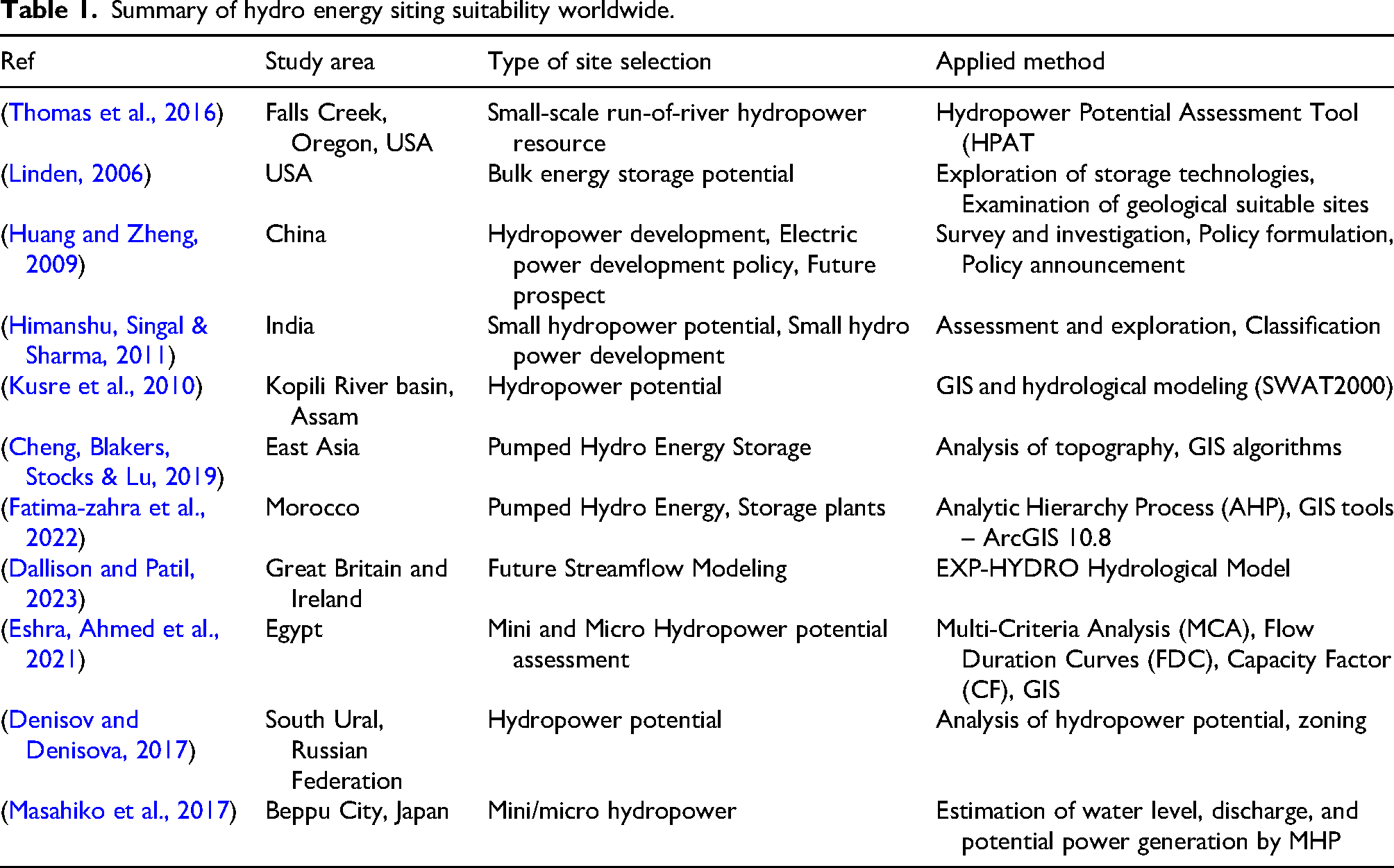
Summary of hydro energy siting suitability worldwide.
Pairwise comparison matrix for criteria weighting.
Weights derived from the eigenvector method.

Quantitative validation metrics.

Sensitivity analysis.

Drainage density of south zone.
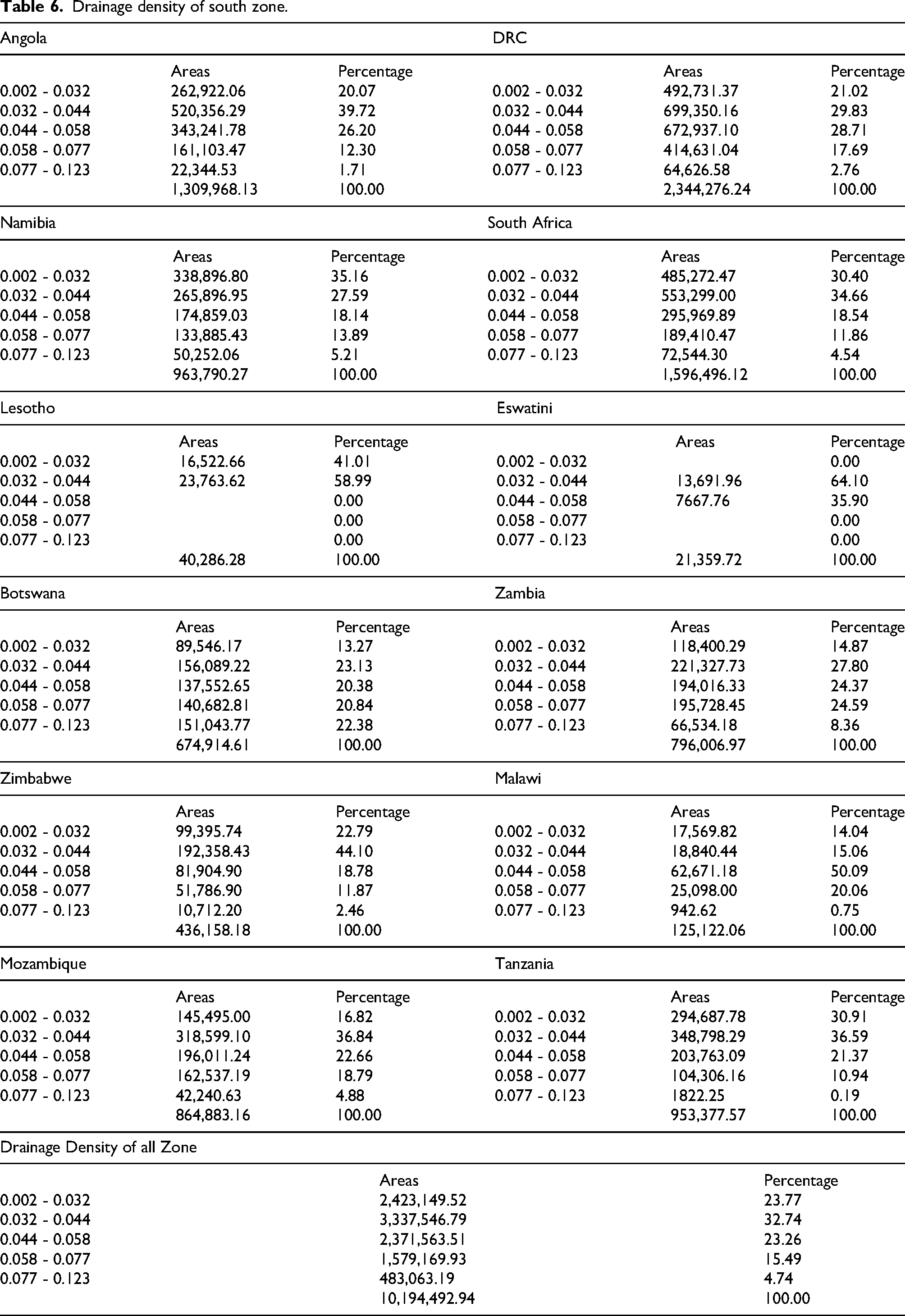
Figure 1 shows the spatial distribution of drainage density across the Southern African Power Pool (SAPP) region, expressed in kilometers of streams per square kilometer (km/km2). Drainage density is a critical hydrological parameter for hydro energy siting because it reflects the intensity of surface water flow and the availability of runoff to feed hydropower systems. The map classifies the drainage density into six classes, ranging from low (light blue) to high (dark blue). Areas with higher drainage density, indicated by darker shades, are more favorable for hydro energy development because of their potential to support higher water yields and consistent streamflow. Conversely, regions with low drainage densities may be less suitable because of limited water availability. This map forms a foundational layer in the geospatial analysis used to identify and prioritize suitable sites for hydro-energy infrastructure within the SAPP region.
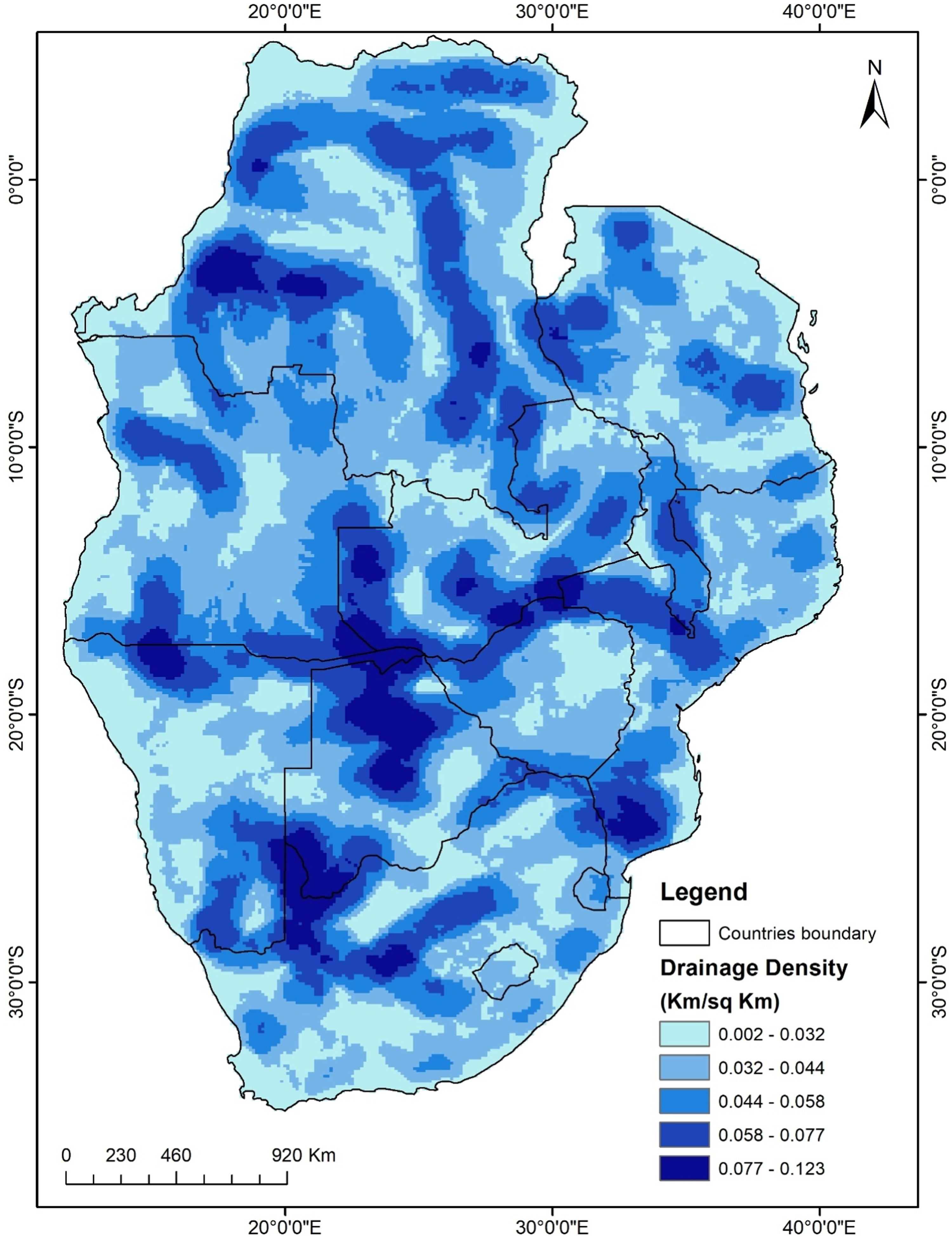
Spatial distribution of drainage density across the SAPP region.
Table 7 details the elevation distribution across SAPP countries, categorized into five elevation classes, ranging from below sea level (−33 m) to high altitudes (up to 5780 m). For each country, the area and percentage coverage within each elevation range were provided. Elevation is a key factor influencing hydropower potential because of its effect on gravitational water flow, with moderate to high elevations generally being more suitable for hydropower development.
South elevation table.

Figure 2 shows the topographical variation across the Southern African Power Pool (SAPP) region, categorized into five elevation classes ranging from below sea level (−33 m) to 5780 m above sea level. Elevation plays a key role in hydro energy suitability, as higher elevations often provide greater potential energy for water flow, which is essential for hydropower generation. Areas with moderate to high elevations (orange to brown) are particularly significant for reservoir-based or run-of-river hydro projects, as they allow for effective gravitational water movement. Conversely, low-lying regions may require additional infrastructure to harness their hydro potential. This elevation data is a fundamental input in the geospatial analysis framework for identifying and evaluating optimal locations for hydropower energy development within the SAPP region.

Elevation and topographic variation in the Southern African power pool.
Table 8 summarizes the spatial distribution of flow accumulation values within the SAPP countries, divided into “High” and “Low” flow accumulation categories. The areas and percentages indicate the extent of land with significant surface water convergence (high flow) versus lesser water accumulation (low flow). High-flow accumulation zones correspond to major river channels and are crucial for identifying potential hydropower sites.
South flow accumulation value table.

Figure 3 illustrates the flow accumulation patterns within the Southern African Power Pool (SAPP) region, indicating how surface water converges and flows through the terrain in the SAPP region. Flow accumulation values are represented by varying line thicknesses and intensities, where thicker and darker lines indicate areas of high-water accumulation, typically major river channels, whereas lighter lines represent low-accumulation zones, such as smaller streams or headwaters. Flow accumulation is a critical factor in hydro energy siting, as it helps identify catchment areas with significant water volumes that are ideal for hydropower development. High-flow accumulation zones suggest strong and consistent water flow that can be harnessed for energy generation. This map supports geospatial analysis by pinpointing key hydrological pathways and potential sites where sufficient runoff converges for viable hydroelectric infrastructure.

Flow accumulation patterns and Major hydrological pathways.
Table 9 lists the geological formations present in each SAPP country, showing the area and percentage coverage of each unit. Geological suitability is vital for hydropower infrastructure stability, with stable rock types, such as Precambrian and Cenozoic formations, being preferred. The table reflects the diverse geological landscapes that influence construction feasibility and water retention.
South geology table.
Figure 4 illustrates the diverse geological formations and rock types that define the structural foundations of the area. Different colors and patterns represent various geological units, including sedimentary basins, metamorphic belts, igneous intrusions, and volcanic formations. In the context of hydro energy suitability, geology is a crucial factor for assessing the feasibility of dam and reservoir construction, as it influences the permeability, structural stability, and water retention capacity. Areas underlain by impermeable and stable rock types are typically more favorable for hydropower development because they minimize seepage and support durable infrastructure. This map serves as an essential layer in multi-criteria geospatial analysis by aiding in the selection of geologically stable and hydrologically sound sites for hydro energy installations across the SAPP Region.
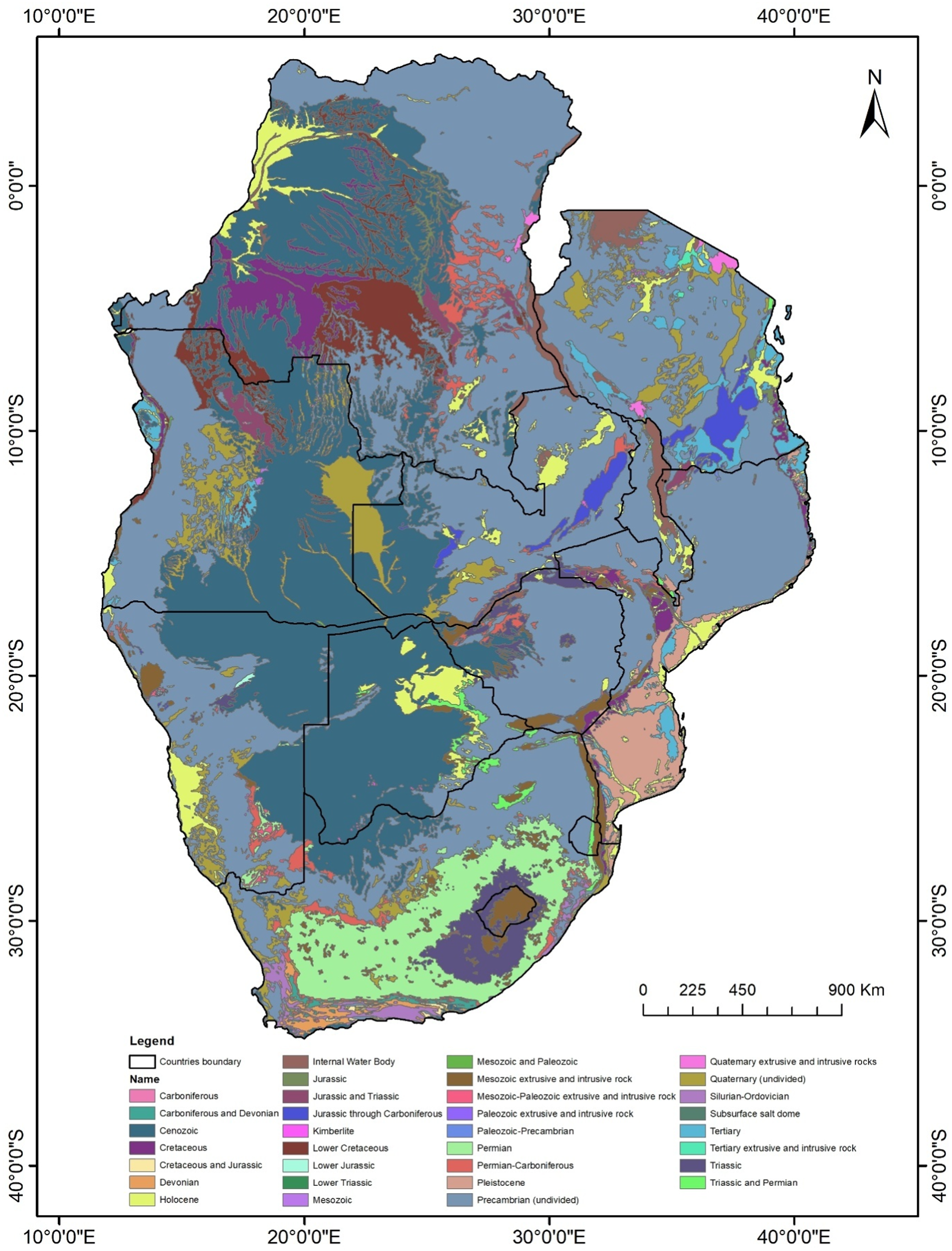
Geological formations and structural suitability for infrastructure.
Table 10 categorizes the land cover types within each SAPP country, including water bodies, trees, flooded vegetation, crops, built-up areas, bare ground, snow/ice, clouds, and rangeland. For each class, the area and percentage of the total land cover were reported. Land cover data inform environmental impact assessments and help exclude unsuitable zones (e.g., dense urban or agricultural areas) from hydropower siting.
South land cover table.
Figure 5 shows the spatial distribution of various surface cover types, including water bodies, forested areas, croplands, built-up regions, and barren land. This classification provides insights into human activity, vegetation cover, and the presence of hydrologically significant features such as wetlands and rivers. In hydro energy siting suitability analysis, land cover data help evaluate the environmental impact of hydropower projects, assess vegetation clearance requirements, and identify areas with minimal ecological disturbance. Regions with dense tree cover or protected ecosystems may face greater environmental scrutiny, whereas areas classified as bare ground or rangeland may offer more feasible development opportunities. The map supports sustainable planning by enabling a balanced assessment of land-use constraints and opportunities for hydro energy development in the SAPP region. Table 11 provides the spatial distribution of annual rainfall within the SAPP countries, segmented into five rainfall intervals (in millimeters). The area and percentage coverage are provided for each interval. Rainfall influences water availability and river discharge, directly affecting the hydropower generation potential. The table shows the precipitation gradients across the region.

Regional land cover classification and environmental constraints.
South rainfall table.
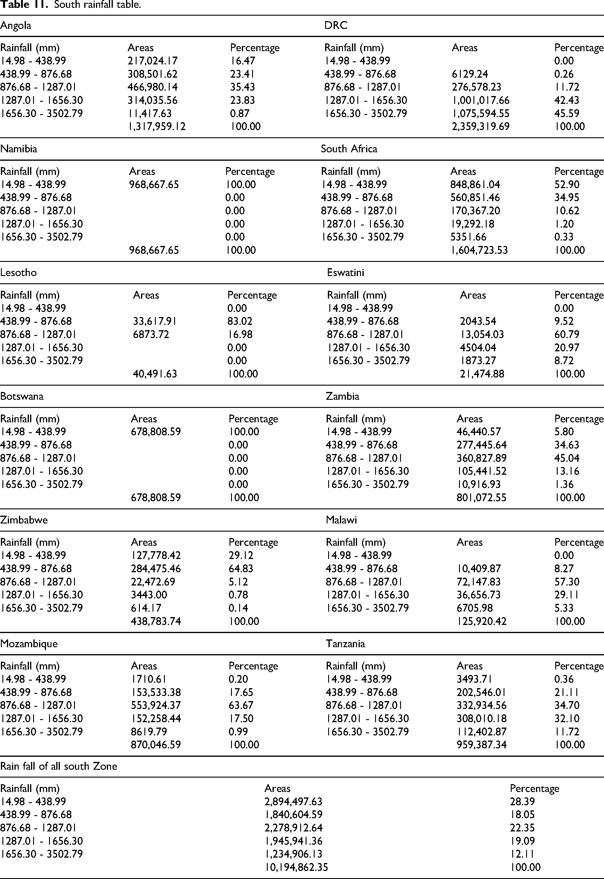
Figure 6 illustrates the spatial variation in annual precipitation across the Southern African Power Pool (SAPP) region, measured in millimeters. Rainfall is a critical factor in hydroenergy siting, as it directly influences water availability and river discharge, which are essential for hydropower generation. The map reveals a gradient ranging from low rainfall areas in the south and southwest (e.g., Namibia and Botswana) to high precipitation zones in the north and east (e.g., parts of Zambia, Malawi, and Northern Mozambique). Identifying regions with sustained and substantial rainfall helps determine the potential catchment areas for hydropower infrastructure. This map is a key input for hydrological modeling and water balance assessments that inform hydro-energy suitability analysis.
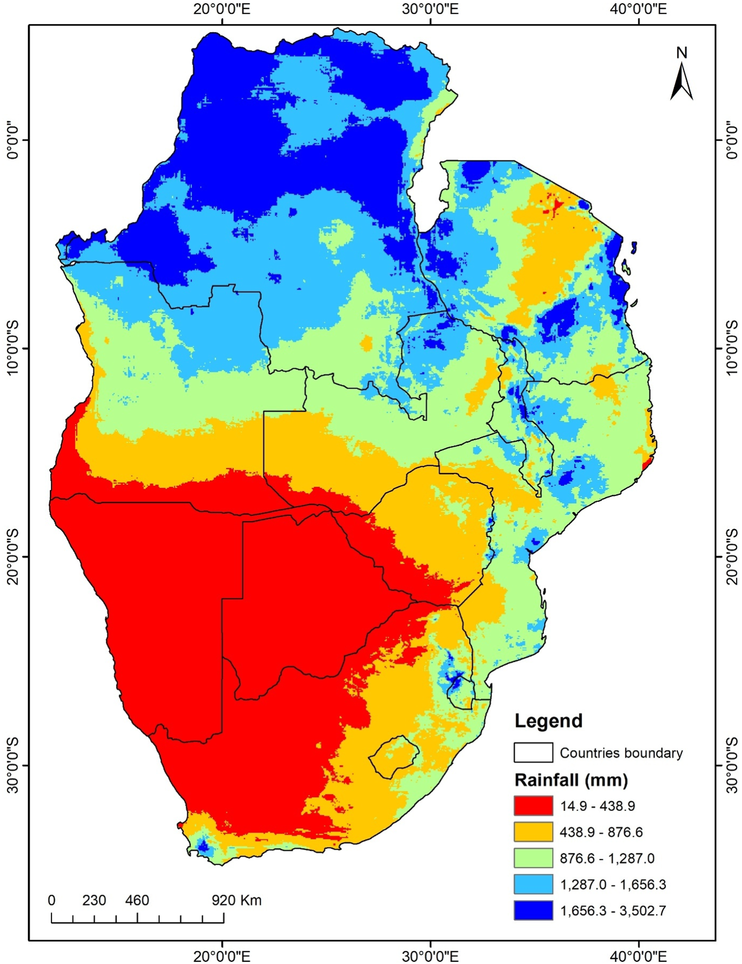
Annual rainfall distribution and precipitation gradients.
Table 12 presents the slope gradient classes (in degrees) for each SAPP country, with the corresponding areas and percentages. Slope affects water flow velocity and hydraulic head, which are critical for hydropower feasibility. Moderate slopes (e.g., 0.91°–10.62°) are typically the most favorable, whereas very flat or extremely steep slopes may pose challenges.
South slope table.
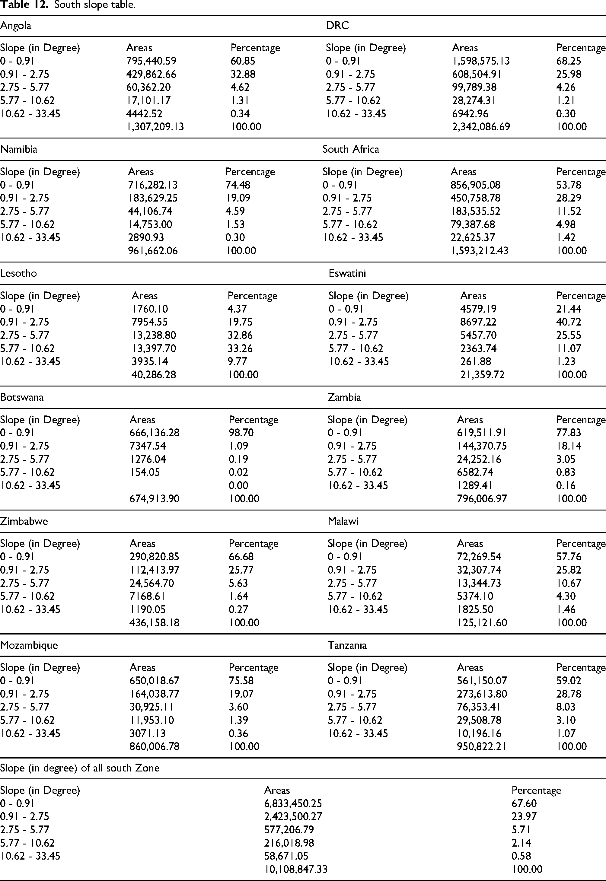
Figure 7 shows the topographic variation across the Southern African Power Pool (SAPP) region, measured in degrees. Slope is a fundamental factor in hydro energy siting because it influences water flow velocity, potential energy capture, and the feasibility of dam and reservoir construction. Areas with moderate slopes (typically between 2.75° and 10°) are particularly favorable for hydropower development, as they provide sufficient elevation change to generate energy while minimizing engineering challenges. In contrast, extremely steep or flat areas may pose limitations because of erosion risks or insufficient hydraulic head, respectively. This map aids in identifying optimal zones for run-of-river or storage hydropower systems based on terrain suitability analysis.

Slope gradient and terrain suitability for hydraulic head.
Table 13 details the distribution of soil texture classes—such as clay, clay loam, heavy clay, loam, loamy sand, sand, sandy clay, sandy clay loam, sandy loam, silt loam, and water bodies—across SAPP countries. The areas and percentages indicate the prevalence of each soil type. Soil texture affects water infiltration, retention, and structural stability of dam foundations, influencing hydropower site suitsability.
South soil texture table.
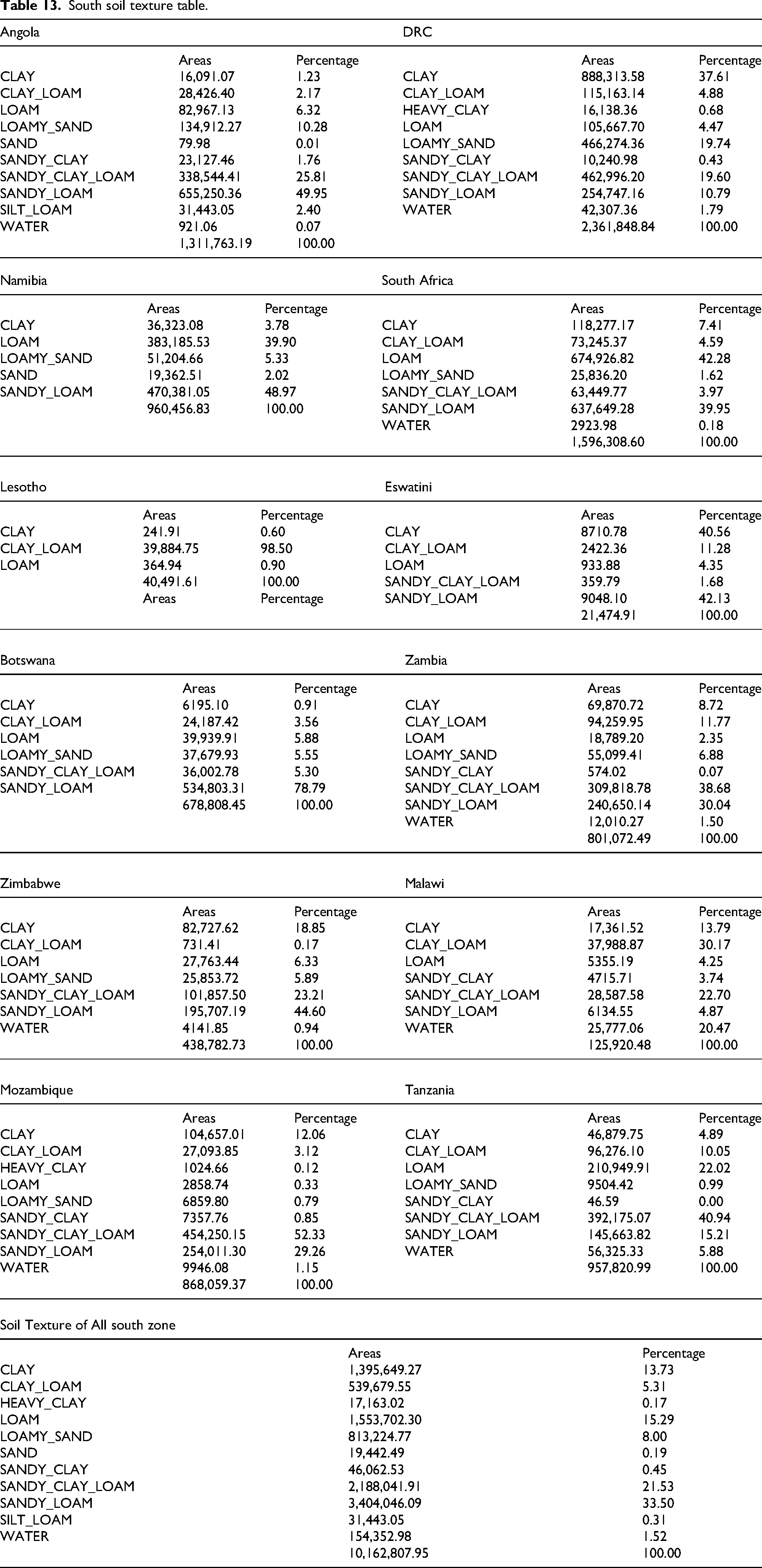
Figure 8 illustrates the distribution of various soil types in the Southern African Power Pool (SAPP) region. Soil texture significantly influences hydro energy siting, especially for dam and reservoir construction, owing to its effects on infiltration, water retention, and structural stability. Coarse-textured soils, such as sandy loam and loamy sand, offer good drainage but may have high seepage rates, which can be unfavorable for reservoir integrity. In contrast, fine-textured soils, such as clay and heavy clay, possess low permeability, making them more suitable for water retention and dam base stability. Understanding soil composition supports the assessment of construction feasibility and environmental impact in hydro energy development planning.
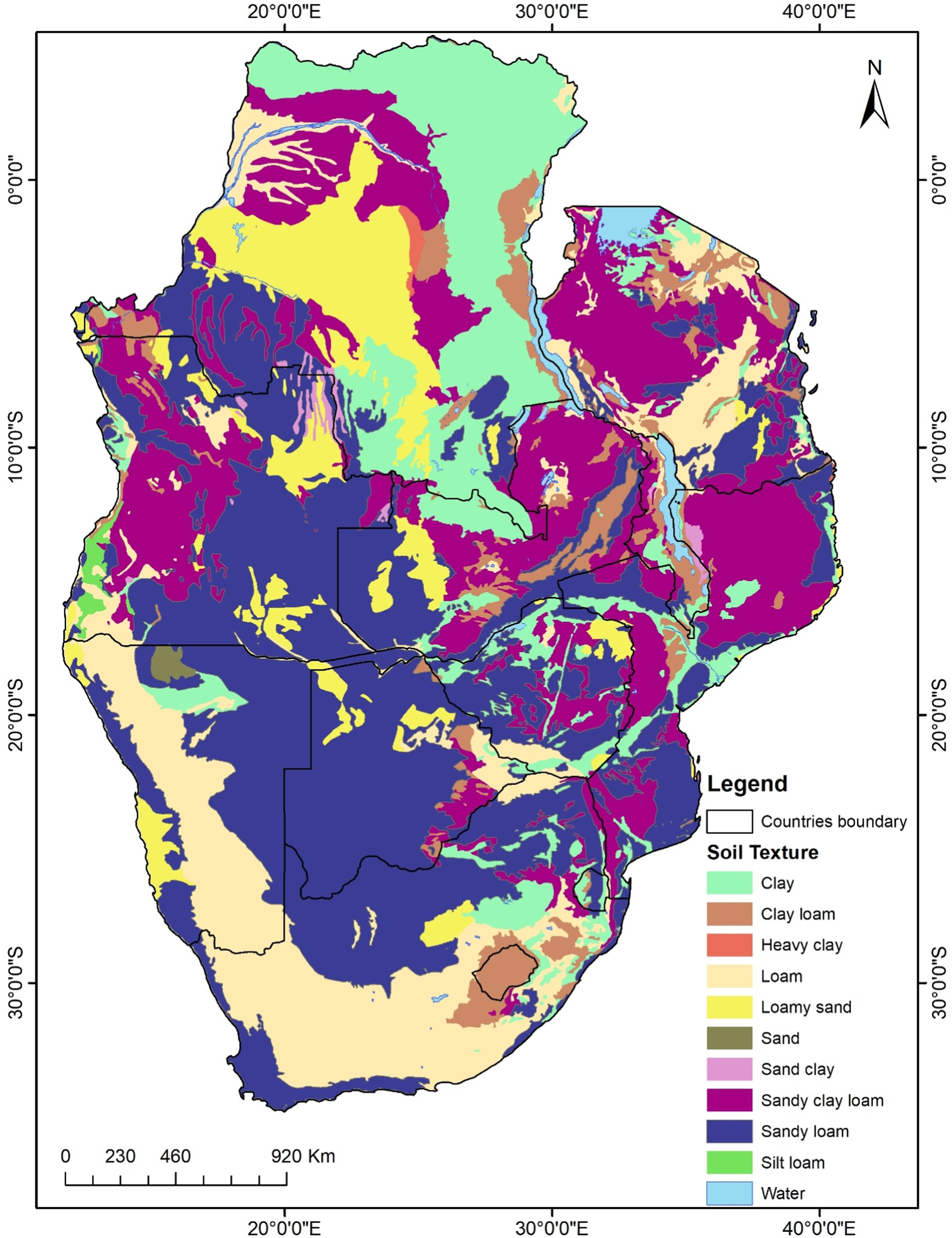
Soil texture map of the Southern African power pool (SAPP) region.
Table 14 shows the distribution of SPI values across the SAPP countries, grouped into several ranges. The SPI is a drought indicator that reflects precipitation anomalies over time. Most areas fell within the lowest SPI range, indicating normal to wetter conditions favorable for hydropower. The data help assess hydrological reliability for energy planning.
South SPI.
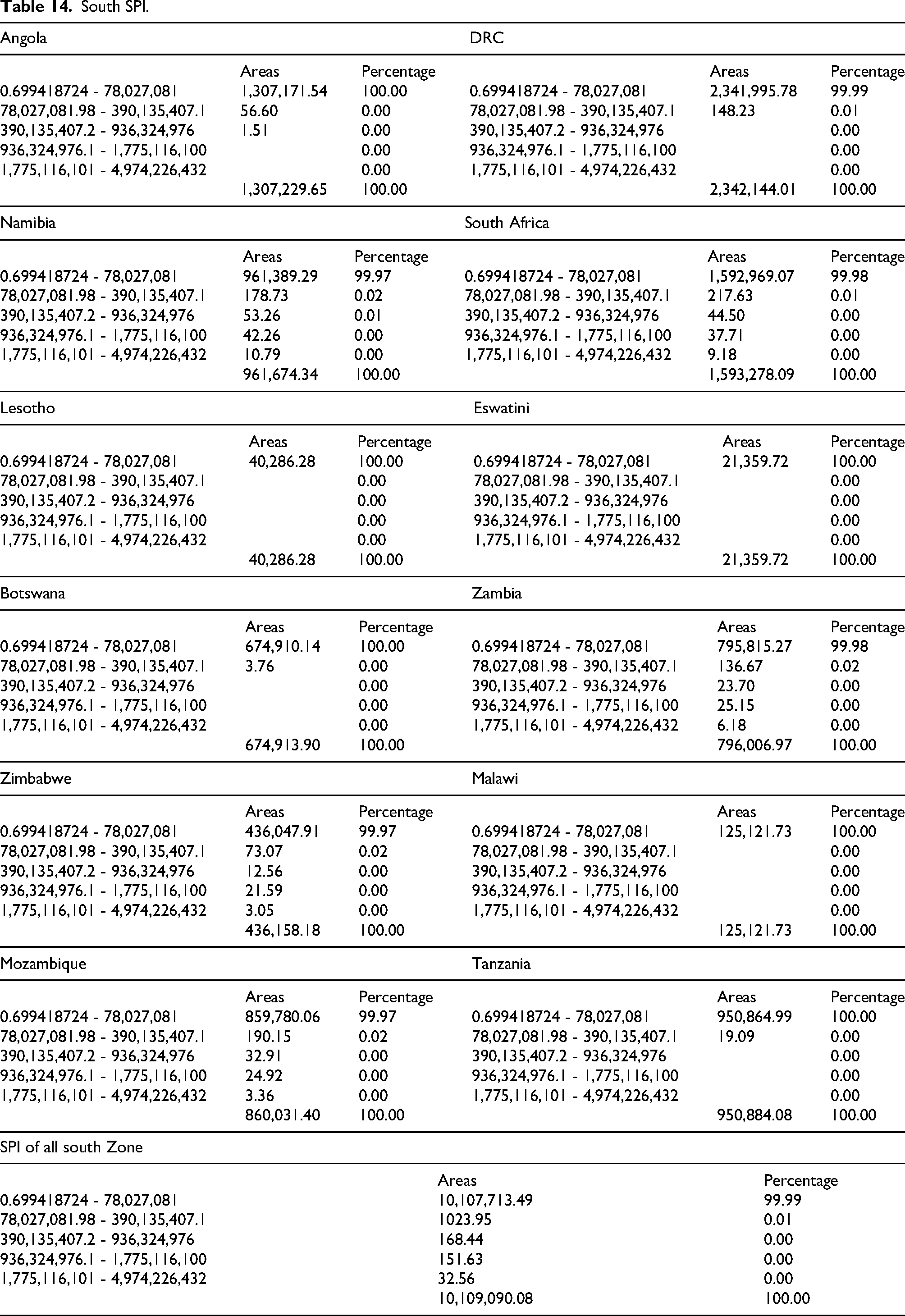
Figure 9 shows the regional variations in precipitation levels over time within the Southern African Power Pool (SAPP) region. The SPI is a critical indicator for drought monitoring and water resource management, providing insights into the frequency and severity of precipitation anomalies. Positive SPI values suggest wetter-than-average conditions, whereas negative values indicate drier-than-average periods. In the context of hydro energy siting, areas with persistently low SPI values may face water scarcity challenges, affecting the sustainability of hydroelectric power generation in the future. Conversely, regions with stable or high SPI values are more favorable for consistent water availability, which enhances the reliability of the hydro energy infrastructure.
Standardized precipitation Index (SPI) map of Southern African power pool region.
Table 15 summarizes the final hydropower siting suitability classification for each SAPP country, divided into five levels: Very Low, Low, Moderate, High, and Very High suitability. The areas and percentages show the spatial extent of each suitability class. The table quantifies the proportion of land in each category, thereby supporting targeted hydropower development planning.
South suitability table.
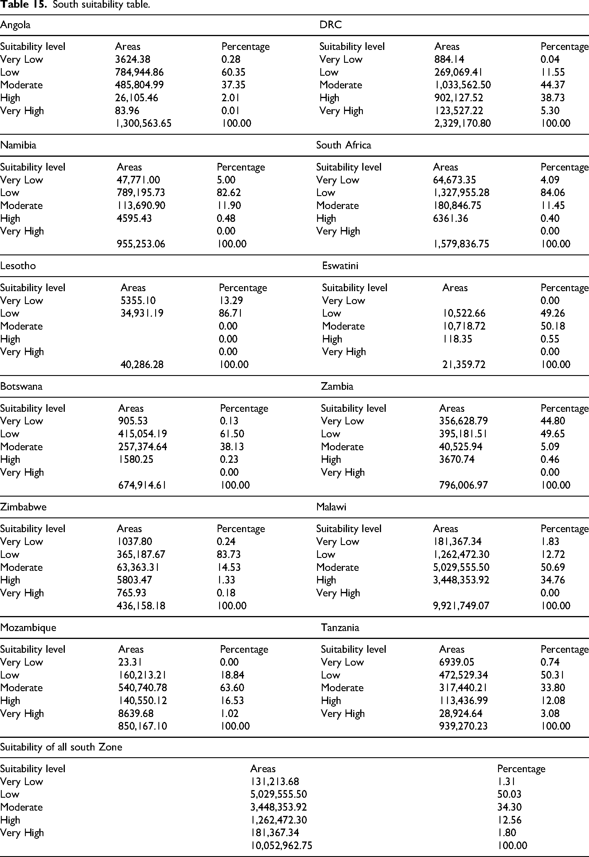
Figure 10 Rather than reiterating the spatial patterns shown in individual suitability maps, the final hydro-energy suitability results highlight clear contrasts in development potential across countries within the Southern African Power Pool (SAPP). Countries within the central and northern SAPP, notably the DRC, Zambia, Tanzania, and Mozambique, consistently exhibit large contiguous zones of high to very high suitability. These areas benefit from the combined influence of dense river networks, moderate slopes, favorable rainfall regimes, and stable geological conditions, indicating strong regional clustering of hydropower potential. In contrast, southern and south-western countries such as Botswana and Namibia are dominated by low to very low suitability zones, primarily due to limited drainage density, flat terrain, and arid climatic conditions, which constrain economically viable hydropower development.
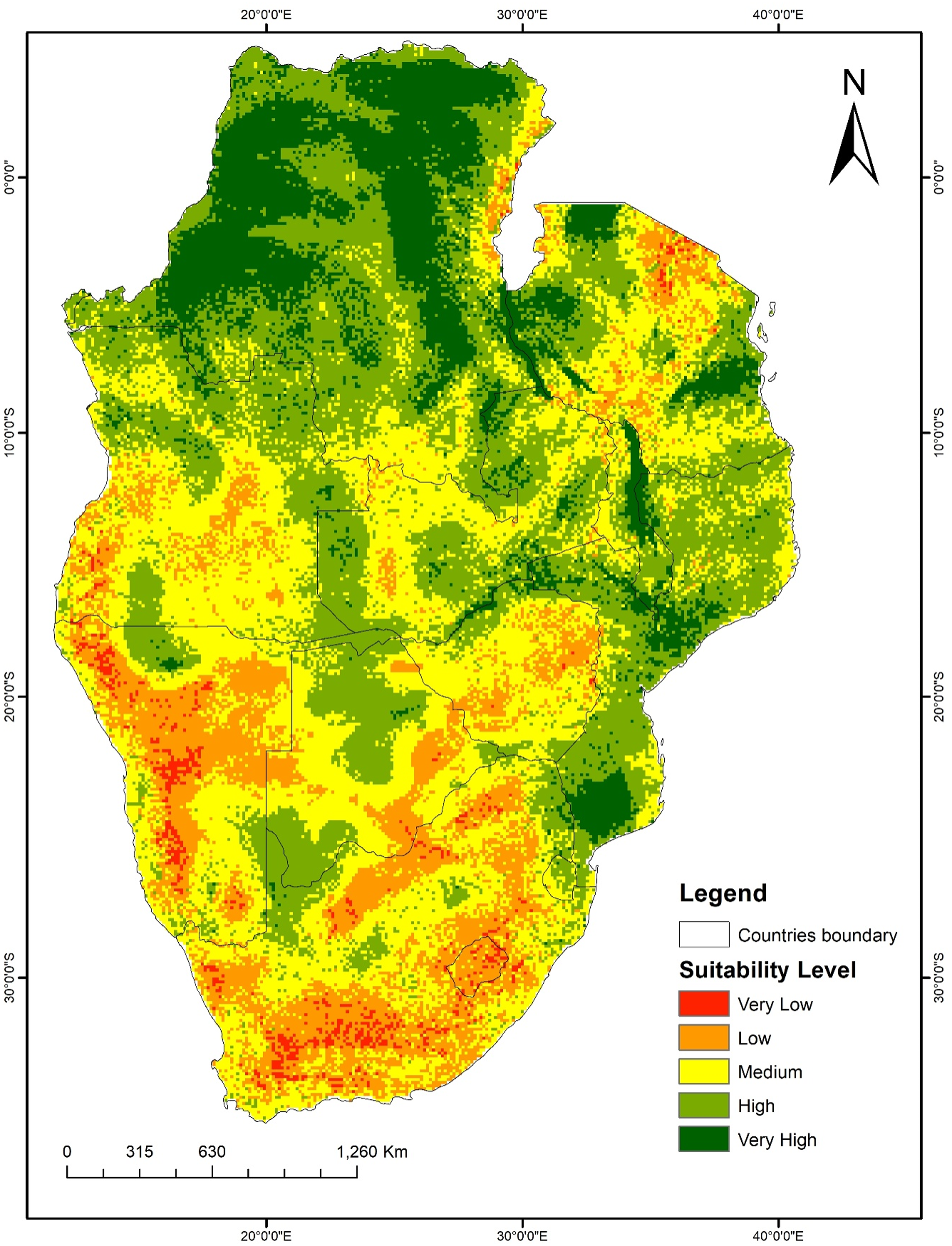
Hydro energy siting suitability map of the Southern African power pool region.
Comparing suitability classes further reveals that very high suitability zones are spatially limited but strategically significant, often concentrated along major river basins such as the Congo, Zambezi, and Rufiji systems, where multiple favorable factors converge. Medium suitability zones form transitional belts across several countries, suggesting opportunities for small- to medium-scale hydropower projects where site-specific optimization may overcome localized constraints. Overall, the comparative distribution of suitability zones underscores a pronounced north–south gradient in hydropower potential across the SAPP region, reinforcing the need for differentiated national and regional planning strategies rather than uniform development approaches.
Interpretation
The geospatial MCDA–AHP assessment revealed substantial spatial variability in hydropower development potential across the Southern African Power Pool (SAPP) region. Hydrological, topographical, geological, climatic, and land-use factors collectively shape land suitability patterns.
Drainage density:
High drainage density values (0.032–0.058 km/km2) were concentrated in the DRC, Zambia, Mozambique, and Tanzania, covering approximately 58–60% of their territories Table 6. These regions present favorable hydrological conditions for future hydropower generation. In contrast, Botswana and Namibia showed very low drainage densities, reflecting limited surface water availability. (Table 6, Figure 1)
Elevation and slope:
Most of the region is situated between 419 and 1491 m. Moderate slopes (2.75°–10.62°), which are optimal for hydropower owing to their balanced hydraulic heads, were mainly found in Zambia, Tanzania and Mozambique. Flat terrain dominates Botswana and Namibia, thereby reducing their suitability. (Table 7, Figure 2)
Flow accumulation:
Major river basins, including the Congo, Zambezi, Limpopo, and Cuanza rivers, were identified as high-flow accumulation zones, closely aligning with areas of high drainage density and enhancing the hydropower potential. (Table 8, Figure 3)
Geology:
Favorable stable geological formations, especially Precambrian and Cenozoic units, dominate Angola, Namibia, and the DRC and offer strong foundations for dam construction. Unsuitable geological areas, such as those with unconsolidated sediments, were excluded from consideration. (Table 9, Figure 4)
Land cover:
Forests and Rangelands dominate this region. Dense forests in the DRC, Angola, and Mozambique and rangelands in Botswana and Namibia shaped the suitability results. Built-up and agricultural lands were excluded to minimize environmental and social disruption. (Table 10, Figure 5)
Rainfall and SPI:
High rainfall and positive SPI values were concentrated in northern Zambia, Malawi, Tanzania, and Mozambique, indicating stronger and more reliable hydrological regimes, which are critical for hydropower supply. (Table 11, Figure 5: Regional Land Cover Classification and Environmental Constraints. Figure 6)
Soil texture:
Sandy loam and sandy clay loam soils in Angola, Zambia, and Mozambique were found suitable for reservoir construction, while more water-retentive clay soils were typical in the DRC and Zimbabwe. (Table 13, Figure 8)
Overall suitability:
The weighted overlay produced five suitability classes: approximately
Validation and sensitivity
Existing hydropower stations strongly overlapped with the predicted high-suitability areas, confirming the reliability of the model. Sensitivity analysis (±10–20% weight variation) produced only minor changes, indicating a robust suitability model.
Discussion
The geospatial analysis across the Southern African Power Pool (SAPP) region offers a first-of-its-kind harmonized, multi-country hydropower suitability model that integrates hydrological, topographic, climatic, geological, and land-use datasets via an AHP-MCDA framework. High-potential hydropower corridors cluster along major transboundary rivers (Congo, Zambezi, Cuanza, and Limpopo), where flow accumulation, elevation gradients, and stable geology converge, confirming optimal sustainable sites across the 12 SAPP countries. These findings align with foundational studies emphasizing perennial rivers and mountainous terrain (Ballance et al., 2000; Kaunda et al., 2012) and support regional assessments identifying the DRC, Zambia, Tanzania, Angola, and Mozambique as hydropower hotspots ((Kichonge, 2018; Gnassou, 2019).
Incorporating rainfall and the Standardized Precipitation Index (SPI) enhances the model by highlighting hydrologically reliable zones, which are critical under climate variability (Kachaji et al., 2016; Lucy et al., 2020). Arid countries like Botswana and Namibia show limited suitability, consistent with prior hydrological constraints (Agarwal, O. M., M. T. & E., 2018; Corbett, 1999) Environmental sustainability is addressed through exclusion masks for protected areas and sensitive zones, ensuring ethical site selection in fragile ecosystems (Corbett, 1999) ; (Helene and Sjöstedt, 2015)
This study advances beyond prior basin- or national-scale assessments (Kaunda et al., 2012; Mwendera, 2006).by harmonizing multi-country datasets and integrating underutilized criteria such as SPI and detailed soil texture, which are crucial for climate resilience and infrastructure stability (Bhowmik et al., 2025; Miguel M., Juízo, & Kenneth, Hydro Power Potential in Mozambique “CHUA- MANICA”, 2015). Sensitivity analysis confirmed model robustness to ±10–20% weight variations, with slope and hydrological factors as dominant drivers, consistent with international findings (Eshra, Ahmed et al., 2021; Fatima-zahra et al., 2022). Validation against existing hydropower infrastructure further supports the predictive accuracy and practical utility of the model.
The regional-scale suitability assessment transcends national boundaries, enabling integrated energy planning within the SAPP. It identifies transboundary hydropower corridors to optimize resource allocation, infrastructure investment, and grid interconnection, promote coherence between national and regional energy strategies, and support economic integration. The spatially explicit maps underscore the need for cooperative governance of shared water resources, facilitating joint environmental assessments, coordinated infrastructure development, and equitable benefit sharing across member states.
The findings align with SAPP's institutional goals to enhance regional electricity trade and infrastructure through evidence-based spatial guidance. Policymakers can use these maps to prioritize feasibility studies, environmental impact assessments, and cross-border coordination, embedding environmental and climatic constraints into adaptive planning for resilience. Emphasizing hydrological reliability via the SPI supports long-term energy security by prioritizing sites that are resilient to drought and climate variability, thus enhancing grid stability and sustainable power supply.
Practically, the suitability classification offers a clear spatial hierarchy for targeted resource allocation and phased developments. This facilitates harmonized regulatory frameworks, streamlined permitting, and the mobilization of financing at multiple governance levels. Integration with grid expansion, conservation, and socioeconomic programs maximizes benefits while minimizing adverse impacts.
Overall, this study complements the broader literature emphasizing hydropower's role in energy security, low-carbon development, and economic growth (Lemba, Ferreira & Robaina, 2021; Bekker et al., 2022), while addressing environmental, social, and climate risks through responsible siting. It provides a scalable, reproducible, and regionally integrated geospatial framework tailored to the SAPP, delivering actionable insights for policymakers, planners, and investors. This foundation supports coordinated, climate-resilient, and socially inclusive hydropower development strategies across Southern Africa, filling gaps in cross-border cooperation and multi-criteria integration that remain unresolved in previous studies.
Conclusion
This study provides a comprehensive geospatial evaluation of hydropower siting suitability across the Southern African Power Pool. By integrating multi-criteria decision analysis with high-resolution spatial datasets, the model successfully identified high-priority areas for hydropower development while accounting for environmental and socio-technical constraints. The results revealed that although large portions of the SAPP region exhibited low suitability, several river basins, including Congo, Zambezi, Cuanza, and Limpopo, contained extensive high-potential corridors. Countries such as the DRC, Zambia, Mozambique, Tanzania, and Angola hold the greatest potential for future hydropower expansion.
The consistency of the SPI model with existing hydropower stations confirms its reliability, and the sensitivity test demonstrates its robustness against weighting changes. The framework developed in this study is reproducible, scalable, and adaptable for national and regional energy planning. Overall, this study provides valuable guidance for policymakers, energy planners, and developers seeking to expand renewable energy capacity in Southern Africa. By identifying optimal hydropower sites while minimizing environmental impacts, this study supports long-term energy security, regional grid stability, and climate-resilient power development in the SAPP region.
Future recommendations include the continuous refinement and updating of the hydropower suitability framework by incorporating more recent and higher-resolution spatial datasets as they become available, including dynamic climate projections to capture evolving hydrological conditions under climate change scenarios. It is advised to integrate socio-economic and infrastructural variables, such as proximity to existing transmission networks, population centers, and economic hubs, to further tailor site prioritization for practical development feasibility.
Enhanced stakeholder engagement and participatory approaches are recommended to incorporate local knowledge, address social acceptance, and ensure equitable benefit-sharing, particularly in transboundary river basins where cross-border cooperation is essential. The methodology should be extended to include environmental impact assessments and biodiversity considerations in greater detail to balance development with conservation goals.
Validation efforts should be expanded with field verification and incorporation of operational data from existing and new hydropower projects to improve model accuracy and reliability. Additionally, the framework can be adapted to assess other renewable energy potentials or integrated energy planning scenarios within the SAPP region.
Finally, policy frameworks should be developed or strengthened to support coordinated regional hydropower development, incorporating adaptive management strategies that account for climate variability and promote sustainable, inclusive energy transitions aligned with regional and global Sustainable Development Goals.
Footnotes
ORCID iDs
Author contributions
All authors contributed equally to this manuscript. All authors have read and agreed to the published version of the manuscript.
Funding
The authors received no financial support for the research, authorship, and/or publication of this article.
Institutional review board statement
The authors declare that the content of this study complies with ethical standards. The authors confirm that this paper has not been published previously, it is not under consideration for publication elsewhere and is not under consideration for publication elsewhere.
Disclosure Statement
All authors declare that the research was conducted in the absence of any commercial or financial relationships that could be construed as potential conflicts of interest.
Data availability statement
The data for this study are available from the corresponding authors upon request.