
Abstract
The Great Divide basin is located in the southern part of the state of Wyoming in USA. Wyoming is the second largest uranium province in that country after the Colorado Plateau. The Great Divide basin represents an intermontane depression of Tertiary age surrounded by major structural uplifts composed of Precambrian rocks including uraniferous Precambrian granite. The main uranium resources of the Great Divide basin are hosted in the weakly lithified sandstone of the Eocene Battle Spring Formation which terminates the sedimentary sequence at the basin. Uranium occurs in the form of rolls and the tabular mineralisation is usually associated with carbonaceous debris in the host sediments. Because of close spatial relationships between uranium and detrital carbonaceous debris the uranium mineralisation of the Great Divide basin is referred to as detrital carbon–uranium roll-type which is a special class of Phanerozoic sandstone hosted uranium deposits. The deposits of the Great Divide basin contain from 2 to 15 kt of U3O8 each, which occurs as uranium rolls and tabular mineralisation, some of which is fault controlled. Their formation is related to multi-episodic uplifts of the Precambrian basement which is exposed along the margins of the basin.
Introduction
Wyoming is a second largest uranium province in the USA after the Colorado Plateau (Dahlkamp, 1993). Uranium mineralisation was discovered in Wyoming in 1918 and the first uranium operation was opened in 1957. Uranium endowment in Wyoming state exceeds 250 kt of U3O8 which is distributed between several main districts: Powder River basin (Davis, 1969; Galloway, 1979), Wind River basin (Ludwig, 1979), Washakie basin, Shirley basin (Melin, 1969; Ludwig, 1978; Shrier and Parry, 1982) and Great Divide basin (Sheridan et al., 1961; Bailey, 1969).
The Great Divide basin is located in southern part of the state of Wyoming (Figs. 1 and 2) and hosts several uranium deposits distributed in the weakly lithified Tertiary sediments. Uranium occurs in the form of the tabular mineralisation and rolls, emplaced along oxidation–reduction fronts. At the local scale the uranium minerals in the Great Divide basin are often associated with carbonaceous debris and therefore the uranium mineralisation in the district belongs to the distinctive class of the Phanerozoic sandstone hosted uranium deposits, referred to as detrital carbon–uranium roll-type (Harshman and Adams, 1981; Dahlkamp, 1993).
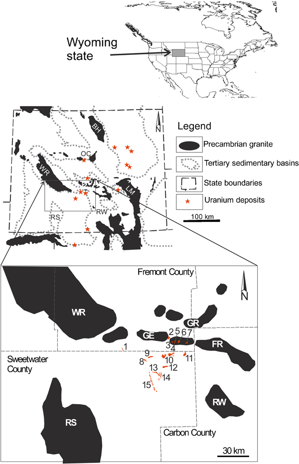
Distribution of the sedimentary basins, uplifts of the Precambrian rocks and the main uranium deposits in the Wyoming state. Uplifts: BH – Bighorn, WR – Wind River, OC – Owl Creek, LM – Laramie, RW – Rawlins, RS – Rock Springs, GE – Green Mountains, GR – Granite Mountains, FR – Ferris Mountains. Uranium deposits of the Great Divide Basin: 1 – Bison Basin, 2 – Sheep Mountain, 3 – Big Eagle, 4 – Desert View, 5 – Phase II, 6 – Jackpot, 7 – Jan, 8 – Schroeckingerite, 9 – Jab, 10 – Antelope, 11 – Lost Soldier, 12 – Lost Creek, 13 – ENQ/B Trend, 14 –Sweetwater, 15 – REB
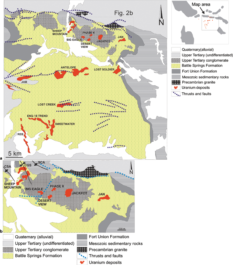
a Geological map of the Great Divide Basin showing distribution of the uranium deposits. Generalised using data of US Geol. Survey; b detailed map of the Green Mountains area. Main structures: CSA – Crooks anticline, CGS – Crooks Gap (Sheep Mountain) syncline, SCA – Sheep Creek anticline
This paper reviews the regional geology and stratigraphy of the Great Divide basin and describes several uranium deposits distributed in the basin which are representative of the given class.
Data
The geological characteristics of the Great Divide basin and selected deposits have been compiled from various publications available in the public domain (Bailey, 1969; Rackley, 1972; Peterman and Hildreth, 1977; Stuckless et al., 1977; Ludwig and Stuckless, 1978; Stuckless and Nkomo, 1978; Harshman and Adams, 1981; Dahlkamp, 1993). Additional information was obtained from the annual reports and public announcements of companies operating in the district.
Regional geology
The Great Divide basin represents an intermontane depression of Tertiary age (Harshman and Adams, 1981). The basin is surrounded by major structural uplifts. On the north and northeast, the Great Divide basin is bounded by the Sweetwater uplift and Rawlins uplift, marking the northern and north eastern boundaries of the basin. The western and north western boundaries are marked by the Rock Springs and the Wind River uplifts, respectively (Fig. 1). Outcrops in the Great Divide Basin are dominated by coarse-grained arkosic sandstone of the Eocene age Battle Spring Formation (Figs. 2 and 3). Uplifts surrounding the basin are composed of Precambrian rocks of the platform basement comprised mainly of uraniferous granites (Stuckless and Nkomo, 1978).
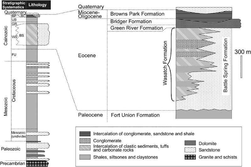
Stratigraphy of the Great Divide basin. Sedimentary formations: BC – Bishop Conglomerate, BP – Browns Park, BS – Battle Spring, FU – Fort Union, GR – Green River, UB – Uinta and Bridger, WS – Wasatch
Stratigraphy
The sedimentary sequence composing the Great Divide basin and underlying basement includes Palaeozoic, Mesozoic and Cainozoic sediments, with a total thickness exceeding 7000 m (Fig. 3). The stratigraphic sequence in the district is terminated by Eocene sediments including the Battle Spring Formation. This formation hosts the main uranium resources of the Great Divide basin including the Sweetwater, Sheep Mountain, Lost Creek and several smaller prospects (Figs. 1 and 2).
The Battle Spring Formation is composed of coarse clastic sediments deposited as alluvial fluvial fans related to south-southwest flowing palaeodrainages. The source of the sediments is considered to be the Granite Mountains, exposed at the Sweetwater uplift approximately 50 to 70 km to the north of the basin (Fig. 4). The thickness of the Battle Spring sediments extends to a maximum of 1830 m (Fig. 3). It is formed as a result of multiple sedimentary cycles related to several episodes of tectonic uplifts. Each cycle starts with conglomerate deposited at the base of the cycle that is related to an intense pulse of tectonic uplifting. The conglomerate is overlain by coarse grained arkosic sandstones related to slowed tectonic activity which gradually change to finer grained sequences of cross-bedded sandstone and siltstone. The latter is distributed across the district as braided and meandering palaeochannels. The cycles are terminated by sequences of mudstone, claystone and siltstone intercalated with fine grained sandstone.
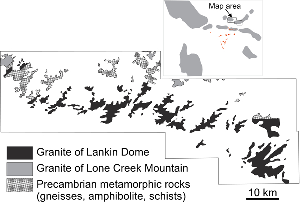
Generalised Precambrian geology of the Granite Mountain area (modified after Stuckless and Nkomo, 1978)
The Battle Spring Formation interfingers with the Wasatch and Green River Formations of Eocene age (Fig. 3). The Wasatch and Green River Formations represent low-energy fluvial, lacustrine and paludal depositional environments.
Host rock alteration
Uranium roll-type mineralisation which is distributed in the Battle Spring Formation is associated with oxidation of the host rocks caused by continuous down-gradient flow of ground water and infiltrating meteoric water. Pervasive oxidation of the host rocks intersects reduced portions of the formation at a high angle forming a tongue shaped front, which is a classic feature of the uranium roll-type deposits (Dahlkamp, 1993).
Alteration is expressed in the distinct changes of mineralogy and chemical characteristics between altered and unaltered rocks. The most common characteristics of the sandstone altered by oxidising solutions that have formed uraniferous rolls are as follows:
change in colour from grey or greenish grey in unaltered sandstone to brown and yellow and greenish yellow in altered (oxidised) sandstones
partial or complete destruction in the oxidised sandstone of heavy minerals, particular pyrite and magnetite
increase in selenium content in the oxidised sandstone
lower calcite and sulphate contents in oxidised sandstone
abundant organic carbon in the altered and unaltered sandstone, however the content of detrital organic carbon decreases in the oxidised sandstone.
Thicknesses of the oxidation fronts vary from several metres to several tens of metres with strike length reaching tens of kilometres.
Granite
Uranium deposits at the Great Divide basin are spatially associates with Precambrian granites exposed at the topographic uplifts, in particular at the Green Mountains (Fig. 2b), Granite Mountains (Fig. 4) and Ferris Mountains (Fig. 1). The best studied are granite in the Granite Mountains (Peterman and Hildreth, 1977, 1978; Stuckless et al., 1977; Stuckless and Nkomo, 1978) which are described below.
The Precambrian metamorphic sequence exposed at the Granite Mountains is composed by biotite-quartz-feldspar gneiss of tonalitic and granitic geochemical affinities which are intercalated with small amount of amphibolite, serpentinite and schist (Fig. 4). The sequence has been intruded by Precambrian granite and dykes.
Granites are subdivided onto two types (Stuckless and Nkomo, 1978): older granites which have a dark red colour and are foliated sympathetically with their host metamorphic rocks and younger granites, which are light grey in colour and non-foliated. The zircon age of the first type of granite is 2640±20 My and of the younger granite is 2595±20 My (Ludwig and Stuckless, 1978). Local names for older and younger granites at the Granite Mountains are Long Creek Mountain Granite and Lankin Dome Granite, respectively (Peterman and Hildreth, 1977).
The granite distributed at the Granite Mountains are characterised by high alkali and silica contents (Fig. 5a). Their composition is plotted in the fields of granite and alkali-feldspar granite on the diagram of Na2O+K2O vs SiO2 of Middlemost (1985). The K2O content varies from less than 1% to approximately 8% (Stuckless et al., 1977; Stuckless and Miesch, 1981). Variation of the potassium content has been attributed by Stuckless et al. (1977) to hydrothermal alteration of the granite which resulted in it silicification, partial or total replacement of potassium feldspar and replacement of biotite by chlorite, iron-oxides and epidote. Because of high potassium and silica contents the granites of the Granite Mountain area have been classified as A-type alkali feldspar granite (Stuckless et al., 1977).
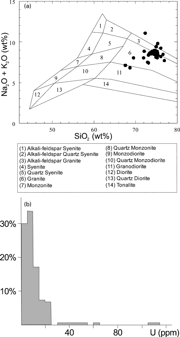
The granite plutons of the Granite Mountains are consistently enriched with uranium with concentration from 0·2 to 110 ppm with average 11·2 ppm (Fig. 5b). This is significantly higher than average uranium concentrations in granite of 2–6 ppm (Rogers and Adams, 1969).
Detailed mineralogical studies by Stuckless et al. (1977) have shown that uranium is accommodated in biotite and to a lesser degree in epidote and also in opaque alteration products of biotite and chlorite. Accessory minerals, zircon and titanite are the main host of uranium in leucocratic phases. Concentration of uranium increases along the fracture joints where it is accommodated in iron oxides and hydro-oxides.
Tectonics
Deep-seated regional thrust faulting occurs along the northern boundary of the Great Divide Basin (Fig. 2a and b) and in its central portion where it is associated with the Wind River thrusting. The horizontal component of displacement is possibly greater than 15 km (O.Paulson, written communication). Normal faulting is also common in the district. Their preferential orientation is generally east–west (Fig. 2a). The normal faults are discontinuous and represent local structural features and are not related to the regional geology. They are related to the late stages of the structural history of the basin and have been formed mainly as a result of basinal consolidation and settling.
Sedimentary strata within the Great Divide basin generally dip at one to three degrees toward the basin centre. The dip generally increases to as much as 20 degrees in locations along the basin boundaries. Gentle folding during the earliest Eocene has accompanied the thrusting and created second and third order structures, including small basins and domes, which have an elliptical shape with their long axis oriented in an east–west direction.
Uranium mineralisation
Uranium mineralisation in the Great Divide basin is concentrated at the edges of the tongue-shaped oxidation fronts (rolls). Precipitation of the uranium occurred when descending groundwater carrying dissolved uranium encountered carbonaceous siltstone from the reducing environment. Uranium is accompanied by selenium, molybdenum and vanadium which are also precipitated in the roll fronts. Selenium and vanadium concentrate mostly on the concave side of the fronts, whereas molybdenum concentrates on the convex side.
The main uranium minerals in the district are pitchblende [pitchblende is a massive brown to black variety of uraninite (UO2). It is fine-grained (colloform), amorphous, or microcrystalline, and has a distinctive pitchy to dull lustre. Pitchblende contains a slight amount of radium; thorium and the rare earths are generally absent] and coffinite (U[SiO4]1−x(OH)4x) which occur as coatings on the sand grains and as interstitial fillings in the voids in the host sediments. Autunite (Ca(UO2)2(PO4)2.10H2O), uranophane (Ca(UO2)2Si2O7.6H2O), brannerite ((U, Th,Ca)[(Ti, Fe)2O6]) and schroeckingerite (NaCa3(UO2)(CO3)3(SO4)F.10H2O) are also present in some deposits however they are less common. Uranium minerals, in general, show spatial association with organic material in the host sandstone which also contains authigenic pyrite (Fig. 6). Uranium minerals are usually distributed at the contact with organic debris and also replacing them (Fig. 6). Petrographic studies (Masursky, 1962; Bailey, 1969) have shown that organic matter at the Great Divide basin was derived from terrestrial plants which were subsequently transformed to sub-bituminous coal by burial metamorphism.
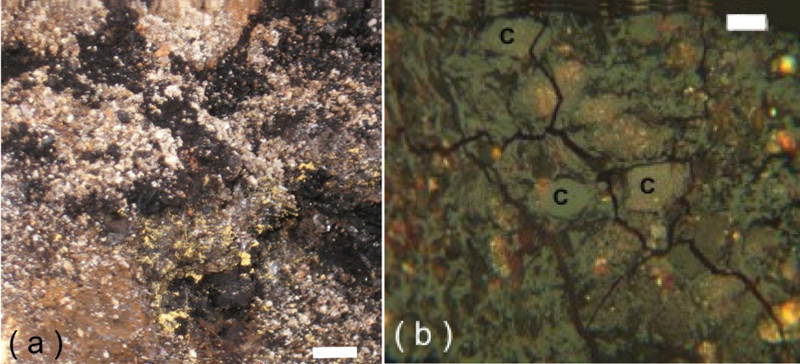
Spatial association of uranium minerals with organic matter: a hand specimen showing uranium mineralisation (bright yellow minerals) distributed at the contact with detrital organic matter (black, angular grains). Scale bar – 5 mm; b photomicrograph in reflected light showing uranium minerals (bright yellow) distributed in the sandstone containing detrital organic matters (denoted as C). Scale bar – 20 μm
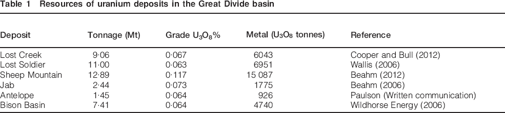
Uranium deposits of the Great Divide basin are usually small in size, containing in general less than 5 kt of U3O8 (Table 1) which is a common feature of the roll-type uranium deposits distributed in the Wyoming region. An exception is the Sheep Mountain deposit which contains approximately 15 kt of U3O8 (Table 1).
Resources of uranium deposits in the Great Divide basin
Lost Creek
The Lost Creek roll-type uranium deposit is located in the north-eastern part of the Great Divide Basin (Figs. 1 and 2a). The deposit is bisected by a minor normal fault system referred to as the Lost Creek Fault (Fig. 7a). It consists of two parallel en-echelon faults trending east-northeast to west-southwest. The easternmost main fault is down-thrown to the south with a maximum displacement of approximately 25 m, tipping-out to zero displacement within the central part of the deposit. A secondary, sub-parallel fault displays opposite displacement of down to the north, with a maximum displacement of approximately 15 m (Fig. 7a). The faulting at the Lost Creek Deposit has clearly offset the sedimentary strata however the relationship between roll-type uranium mineralisation and faulting is not clear. It is possible that faulting has predated the mineralisation and in that case the faults could have acted as a hydrologic barrier causing groundwater velocities to slow as the groundwater attempts to cross the fault zone. This allows uranium dissolved in the groundwater more time to react with reductants present around the fault zone and precipitate in the host sands. The faults can also act as a conduit for reducing waters, bearing dissolved hydrogen sulphide ions, facilitating precipitation of the uranium transported by descending oxidised waters. This precipitation mechanism was proposed for the Zamzow, Felder and McLean deposits in South Texas (Goldhaber et al., 1983).
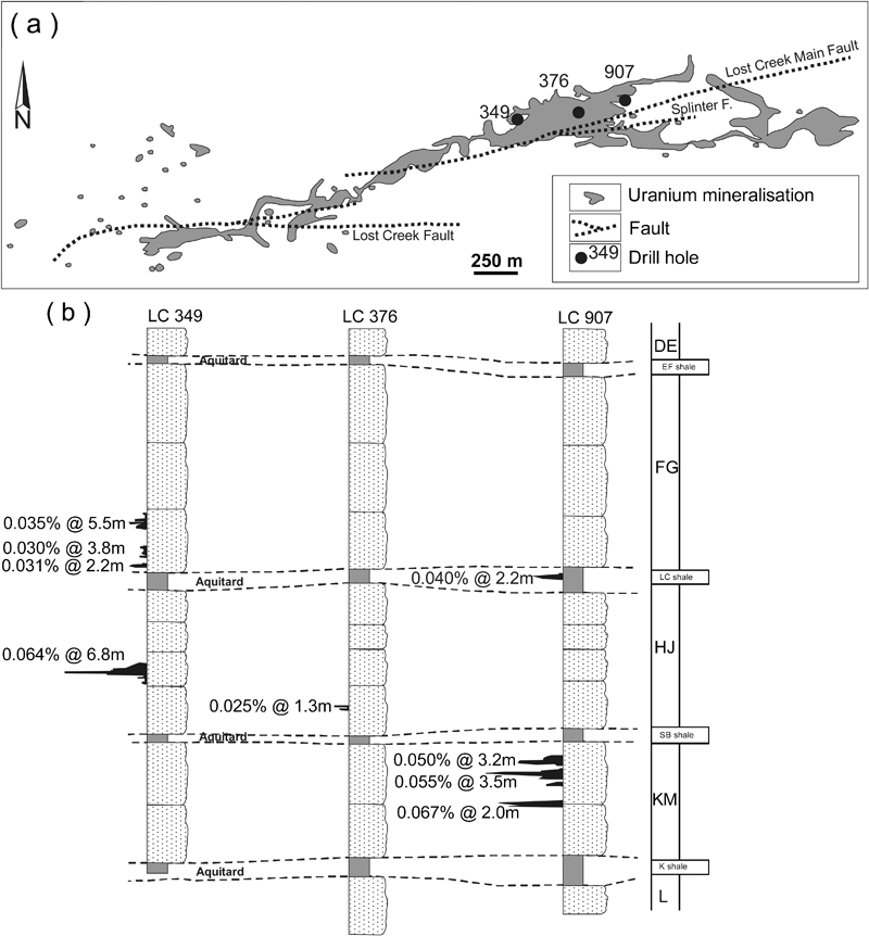
The sedimentary sequence exposed at the Lost Creek deposit area is represented by weekly consolidated arkosic sandstone of the Battle Spring Formation (Fig. 2a). The formation is subdivided into several sandstone units or horizons (Fig. 7b) which are separated by shale layers. The sandstone horizons have thickness varying from approximately 30 to 80 m. The shales, mainly mudstone and siltstone, are distributed as narrow beds, usually not more than several meters in thickness, which are continues across the entire deposit area.
Uranium mineralisation at the Lost Creek deposit is distributed between several horizons of the Battle Spring Formation (Fig. 7b) with most of the currently defined resources hosted by HJ and KM horizons (Cooper and Bull, 2012). The HJ horizon is composed of weakly lithified sandstones approximately 30 to 50 metres thick. The sandstone units have cross bedded textures which is a common feature of the sands deposited in a deltaic environment. The horizon contains eleven individual roll fronts (Cooper and Bull, 2012) with richest uranium concentrations being found in the central part of the HJ horizon (Fig. 7b). The HJ horizon is overlain by the Lost Creek shales (LC shale) and underlain by the Sagebrush shales (SB shale) which separate it from the KM sandstone horizon (Fig. 7b). To date a total of nine roll fronts have been identified in the KM horizon (Cooper and Bull, 2012). Thickness of mineralisation within each roll varies from 1·5 to 8 m. However, several rolls can be juxtaposed creating the stacked profile of the multiple roll-fronts (Fig. 7b).
Shales, overlying and underlying the sandstone sequences, such as HJ horizon, focus the groundwater flow into the sandstones. Continuity of these conditions produced a significant accumulation of uranium at the reduction–oxidation interface. In addition, the continued supply of oxygen to the interface led to degradation of the reducing environment and resulted in down-dip migration of the reduction/oxidation interface, remobilising the associated uranium, and enhancing the grade of uranium rolls.
The reducing environment in the host sand is generally the result of carbonaceous material or leaked reductant gases within the formation (O.Paulson, written communication). Pyrite and marcasite are inherently associated with both and contribute to the reducing environment. Reduced sands are typically some shade of grey. The reducing environment is altered by the passage of the oxidising solution front. At the same time, pyrite and other iron-bearing minerals (marcasite) are oxidised to hematite or limonite and goethite and the carbonaceous material is largely destroyed. As a result, altered (oxidised) sands are typically reddish or yellowish in colour.
The main uranium mineral is coffinite distributed as micrometre- to submicrometre-size inclusions in the clay minerals and more rarely as inclusions in pyrite. Minor amounts of uraninite and brannerite have also been identified.
Sheep Mountain
The deposit is located in the northern part of the Great Divide basin at the Green Mountains area (Figs. 1 and 2b). The sedimentary rocks sub-cropping in the deposit area are mainly arkosic sandstone of the Battle Spring Formation and polymictic conglomerate of the Crooks Gap Formation (Fig. 2b).
The dominant structural feature in the deposit area is the asymmetrical northwest trending southeast plunging Crooks Gap syncline bounded from south–west by the Crooks anticline and from the north–east by the Sheep Creek anticline (Fig. 2b). Beds on the eastern limb of the Crooks Gap syncline dip 45 to 60 degrees to the south–west, whereas the western limb dips 10 to 15 degrees to the northeast (Beahm, 2012). These structures control distribution of uranium mineralisation at the deposit and district scales. Mineralisation at the Sheep Mountain deposit is bounded to the east by the western flank of the Crooks Gap syncline and to the west by the Crooks anticline (Fig. 2b).
Faulting is limited in the deposit area and only the east-northeast-trending fault structure has been identified (Fig. 2b). The fault cuts the east limb of the Crooks Gap syncline. The amount of displacement of the fault is unknown and it is unlikely that displacement exceeds two metres. The largest tectonic displacement reported in the mines operating in the area was approximately 1·3 metres (Beahm, 2012).
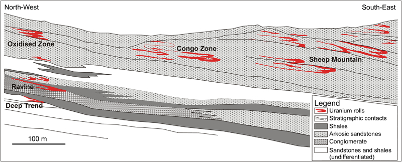
Uranium mineralisation at the Sheep Mountain deposit occurs in stacked horizons distributed between 20 and 300 m below surface (Fig. 8). Mineralisation is present as uranium rolls and the tabular bodies. The rolls are usually located at a shallower depth than the tabular mineralisation. In general, rich uranium accumulations are spatially associated with organic rich lenses in the fine grained sands and siltstones.
Generalised geological cross-section of the Sheep Mountain deposit. Compiled using data of Beahm (2012)
Discussion and conclusions
The Great Divide Basin contains numerous uranium deposits which are distributed in the Eocene Battle Spring Formation. The deposits contain from 2 to 15 kt of U3O8 which is distributed as uranium rolls and tabular mineralisation including fault controlled occurrences. The mineralisation, in general, is spatially associated with carbonaceous debris and is classified by Dahlkamp (1993) as a detrital carbon–uranium roll-type which is a distinctive class of Phanerozoic sandstone-hosted uranium deposits.
Mineralisation was formed in the Oligocene. Apparent ages of uranium mineralisation estimated from U/Pb isotopes scatter from 35 to 26 My (Ludwig, 1979). Uranium was introduced into the sediments as a result of the migration of oxidised ground water, therefore special hydrogeological conditions were needed for the formation of these roll-type deposits. The Great Divide basin is tightly surrounded by uplifted Precambrian rocks creating a fully enclosed hydrogeological basin which is favourable for the occurrence of uranium rolls. Because of its enclosed nature all precipitation remains within the basin and does not exit the basin via any drainage. The ground water continuously flows towards centre of the basin and locally discharges to the surface via seeps and springs that form shallow playa lakes. The groundwater flow is generally focused horizontally by palaeochannels and vertically by shale aquitards which facilitate the formation of the roll-type uranium deposits.
The source of uranium is not known, but is likely to include Precambrian granite exposed in the uplands, arkosic sands derived from the granite and volcanic ash (Fischer, 1970; Stuckless and Nkomo, 1978). Studies of uranium and thorium distribution in the Granite Mountain rocks (Stuckless and Nkomo, 1978, 1980) have shown that biotite and epidote bearing granites are the most favourable sources for uranium deposits in the Great Divide basin of Wyoming. Radiometric dating of the ores (Ludwig, 1978, 1979) broadly coincides with timing of uranium loss from the granite (Stuckless and Nkomo, 1978, 1980; Stuckless and Miesch, 1981). The isotope dates also suggest that mineralisation is older than volcanic rocks in the region (Stuckless and Nkomo, 1978).
Footnotes
Acknowledgements
Critical comments by A. Waltho and reviewers of Applied Earth Sciences journal are gratefully acknowledged.
This paper is part of a special issue on uranium deposits and in-situ leaching