
Abstract
Stream sediment samples were collected in the Trindade–Chança region at 1034 sites for mineral exploration purposes during 1996–97. Concentrations of Cu, Zn, Pb, Co, Cr and Ni are high enough in most sample sites to allow data assessment by multi-element anomaly definition and threshold computation using the area concentration multifractal model technique. The regional threshold values are 20, 45, 30 and 15 ppm for Cu, Zn, Pb and Co respectively. Anomalies for Cu, Zn, Pb, Co, Cr and Ni are delimited by first order local threshold values at 40, 94, 70, 21, 37 and 42 ppm. The main anomalies are clustered to the east-southeast of the surveyed region and reflect mixed contributions from a variety of sources, namely different volcanic units with local contributions from pelite rocks, contamination from old (abandoned) mining activities and hydrothermal mineralisation controlled by different fault zones.
Keywords
Introduction
Stream sediments are heterogeneous mixtures of debris derived from the surrounding watershed, including soils and different weathering products of rocks from the drainage basin upstream of the collection site; this includes various products of human activity whenever they exist and are in conditions to be removed by rainfall or other processes able to feed the watercourses. Consequently, the study of mineral and chemical composition of stream sediments is of considerable value in regional assessments of mineral exploration and environmental impacts. Investigation of stream sediment surveys is also an important tool to unravel the geological background of inaccessible areas, or areas devoid of significant outcrops and covered by dense vegetation.
However, in order to get reliable results and interpretations, stream sediment surveys should take account of the inherent features of the region being sampled. These features include the geomorphology, drainage pattern, bedrock geology and general hydrological conditions, all of which are controlling factors on regolith and soil development, seasonality of stream flow and the variation of the total solid yield of the stream. The understanding of these factors is critical to sampling program design (namely to settle on site density and regularity per area), but additional attention should be given to the preparation and compositional characterisation of samples, as well as to data analysis (e.g. Weber and Davies, 1990; Mukherjee et al., 2007; Alexakis, 2008).
This paper will focus on data analysis by demonstrating the advantages of multi-element anomaly separation and threshold computation using the area concentration multifractal model (Cheng et al., 1994; Gonçalves, 2001). As a case-study, the technique was used to analyse Cu, Zn, Pb, Co, Cr and Ni distribution in stream sediments collected at 1034 sites of an irregular grid extending along the contact between the Pulo do Lobo Terrane (PLT) and the South Portuguese Zone in Portugal, from Trindade to Chança; this area partly overlaps the NE domain of the Iberian Pyrite Belt (IPB).
Geological and geomorphic features of the study area
The study area is located in the southern region of the Portugal mainland, along the northern domain of the South Portuguese Zone (of Avalonian affinity). The area lies south of the Variscan suture, which separates the South Portuguese Zone from the Ossa-Morena Zone that is part of the Iberian Terrane of Gondwanan affinity (e.g. Ribeiro et al., 1990, 2007, 2009; Quesada et al., 1991, 1994; Jesus et al., 2007). The prevailing geological feature of the area is the tectonic contact between the PLT (to the north) and the IPB (to the south; Fig. 1). Both Terranes comprise geological formations of Devonian to Carboniferous age, and lithologies that are affected by intense poly-phase deformation and relatively low grade regional metamorphism (e.g. Schermerhorn, 1971; Ribeiro, 1981; Munhá, 1983a, 1990; Ribeiro and Silva, 1983; Quesada, 1998; Abad et al., 2001; Onézime et al., 2002; Jesus et al., 2007; Pereira et al., 2008).
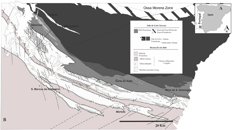
(A) location of the study area compared to the general geological framework of SW Iberia and (B) fundamental geological features of the Trindade–Chança region: adapted from the Geological Map of Portugal at 1∶200 000 scale Fl. 8 (SGP, Oliveira et al., 1992)
The PLT is interpreted to be an accretionary complex (e.g. Silva et al., 1990; Fonseca and Ribeiro, 1993; Ribeiro et al., 2010) that occurs as a large antiform whose core and south limb are well exposed in the surveyed area. The Pulo do Lobo Formation occupies the antiform core and consists of a sequence of phyllite, quartzite and at the base a MORB-type tholeiite (Munhá, 1983b); the thickness of this sequence is unknown and, according to palynostratigraphy constraints, it is pre-Early Frasnian times (Pereira et al., 2008). The antiform south-limb includes three formations (Atalaia, Gafo and Represa Formations from base to top) that together form the Chança Group with an estimated thickness of 1100 m (Pereira et al., 2008). The sedimentary and structural record preserved in the Atalaia Fm. is similar to that found in the Pulo do Lobo Fm. The Gafo Fm. consists of a relatively thick flysh-like succession, dated as Early Frasnian (Pereira et al., 2008), that consists of meta-greywacke, meta-siltstone and shale, occasionally interbedded with, and intruded by, felsic and mafic igneous rocks. The Represa Formation is composed of siliceous meta-siltstone, shale, meta-greywacke and minor intercalations of fine volcanogenic meta-sedimentary rocks and is dated as upper Strunian (i.e. lower Late Famennian; Pereira et al., 2008).
The stratigraphic succession of the IPB (e.g. van den Boogard, 1963; Oliveira, 1990; Moreno et al., 1996; Pereira et al., 2008) includes two main units resting on an unknown basement of possible continental nature, as inferred on the basis of geophysical evidence (e.g. Simancas et al., 2003; Vieira da Silva et al., 2007). From bottom to top, these units are known as the Phyllite-Quartzite Group (PQG) and the Volcano-Sedimentary Complex (VSC), which are followed by the Baixo Alentejo Flysh Group (BAFG). The rocks in the study area have been deformed by Variscan thin-skinned, S-verging tectonics, leading to the development of allochthonous sections of variable thickness with tectonic sheets of PQG and VSC that co-exist with para-autochthonous and autochthonous VSC sequences; here, the BAFG is represented by the Mértola Fm. (e.g. Silva, 1989; Oliveira et al., 2005, 2006; Rosa et al., 2006, 2009; Pereira et al., 2007, 2008). The PQG, which is Late Devonian in age, corresponds to a siliciclastic succession mainly formed by phyllite, quartzite, meta-quartzwacke and shale that, in its upper portion, may include lenses and nodules of meta-limestone. The VSC, which has an age from Late Famennian to Late Visean times, comprises lithologies of several volcanic episodes (submarine and bimodal although with prevalence of rhyolitic-dacitic compositions) interfingered with meta-sedimentary rocks of clastic (various types of shale, occasionally complemented by meta-siltstone and meta-quartzwacke) and chemical (mostly jasper) nature. This stratigraphic unit hosts the S. Domingos and Chança massive sulphide deposits, as well as other exhalative occurrences in the area (e.g. Carvalho, 1979; Matos and Martins, 2006; Matos et al., 2006). The BAFG, dated from Late Visean to Middle-Late Pennsylvanian, is a syn-orogenic turbidite sequence up to 5000 m thick prograding continuously to the south; its base, corresponding to the Mértola Fm., is mainly formed by a sequence of meta-greywacke with interbedded slate.
The prevailing geomorphology of the study area consists of smooth landscapes occasionally disturbed by WNW-ESE ridges controlled by erosional contrast related to the underlying geology (PQG quartzite or thick strata of coarse-grained meta-greywacke, and sporadically also meta-quartzwacke tend to be more resistive to weathering). Under a Mediterranean climate, somewhat influenced by the Atlantic Ocean, the typical leptosols of this region are quite vulnerable to desiccation and erosion, limiting the amount of arable farming. The limited permeability of the underlying lithologies in the region results in high run-off rates, promoting the development of dendritic drainage patterns. The run-off is characteristically seasonal with the major discharges that are responsible for stream sediment transport and distribution caused by heavy rainfalls during the winter period and rarely persistent summer storms. The main water course that runs north to south across the study area is the Guadiana River, which also has the Terges and Chança rivers as its principal tributaries; most of the remaining streams are seasonal and do not have water flow for many months. In the Chança river basin down-stream from the São Domingos mine intense acid mine drainage is reported due to the presence of historic mine tailings and dams from the mining operation (Santos Oliveira, 1997; Mora, 1999; Matos el al., 2006; Álvarez–Valero et al., 2008; Abreu et al., 2010). Minor acid mine drainage is also reported from the Chança area, but here the main source is the Spanish Vuelta mine (Alvarenga et al., 2002). In this framework, the Cu, Zn and Pb values displayed by stream sediments should reflect the potential influence of VSC units hosting massive sulphide deposits, locally mixed with inputs derived from old mining activity at São Domingos. In addition, Cr and Ni (±Co) contents in stream sediments may discriminate contributions of mafic meta-volcanic rocks included in the Pulo do Lobo Fm., Gafo Fm. and VSC.
Materials and methods
Sampling survey and geochemical data set
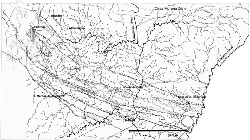
The stream sediment geochemical data set used for the analysis described in this paper is part of a regional database compiled by the Laboratório Nacional de Energia e Geologia (LNEG, Portugal). Stream sediments were collected by the Sociedade Mineira Rio Artezia Lda (SMRA) in the 1996–97 period for mineral exploration purposes from 1034 sites arranged in an irregular grid extending along the contact between the PLT and the South Portuguese Zone in Portugal, from Trindade to Chança (Fig. 2; Castelo Branco and Rosa, 1998; Mora, 1999). Subsequent sample processing and chemical analyses were carried out at Chemex Laboratory (Canada) for 32 elements by four-acid Inductively Coupled Plasma - Atomic emission spectroscopy (ICP-AES); the accuracy and precision of the preparation and instrumental performances were checked by using international reference samples and duplicates respectively. According to results reported in Castelo Branco and Rosa (1998) and Mora (1999), the contents of many elements are often below the detection limit of the analytical procedure used, and this fact posed strong limitations on the selection of elements to be investigated by means of multi-fractal modelling. This is not the case of Cu, Zn, Pb, Co, Cr and Ni for which the accuracy is better than 10% at a concentration level above 0·5 ppm Cu, 5 ppm Zn, 0·25 ppm Pb, 0·05 ppm Co, 0·5 ppm Cr and 2 ppm Ni. Precision, monitored by calculating the average difference between duplicates, is <10% for Cu, Zn, Pb, Co and Cr and <15% for Zn and Ni. The obtained Cu, Zn, Pb, Co, Cr and Ni contents serve properly the objectives of the present work, being also pertinent in face of the geological background of the area surveyed.
Data handling and geochemical mapping procedure
A preliminary statistical analysis of the Cu, Zn, Pb, Co, Cr and Ni values was completed to determine the distribution of each element, as well as identify the presence of multiple populations and outliers. The results from this analysis are summarised in tables and frequency and box-whisker charts for comparison purposes (e.g. Tukey, 1977; Hampel et al., 1986; Barnett and Lewis, 1994; Hoaglin et al., 2000; Reimann and Filzmoser, 2000). Deviations from normality or log-normality behaviour were also investigated for each element distribution, graphically expressed in cumulative probability plots (e.g. Sinclair, 1974; Reimann et al., 2000).
The multifractal character of the Cu, Zn, Pb, Co, Cr and Ni contents in stream sediments of the Serra Branca–Chança region was examined by computing the correspondent multifractal spectrum according to the method of moments (Halsey et al., 1986) corrected for edge effects (Gonçalves, 2001). The threshold computation used the area concentration multifractal model (Cheng et al., 1994). The concentration area model proved successful and provided significant results in several contexts ever since it was first proposed (e.g. Cheng et al., 1994; Gonçalves et al., 1998; Gonçalves et al., 2001; Arias et al., 2012; Jesus et al., 2013). The model is derived based in the assumption that the distribution of the analysed elements follows a multifractal measure (see Appendix), although such verification may not be strictly necessary. This means that the results may still be geologically meaningful in the circumstance that this verification fails. Therefore, a multifractal measure is a sufficient but not a necessary condition to the application of the concentration area model (Gonçalves et al., 2001). However, the extent to which the concentration-area model may be applied to any set of data is not known and has never been proven mathematically starting from different assumptions. The model states that the area A(ρ), enclosing concentration values lesser or equal than a predefined threshold ν, follows a power law relation


Considerable effort was also put into variogram modelling in order to study the spatial variability and anisotropy of each element geochemical distribution. These models of spatial variability were then used in the production of geochemical maps with the gridding software package SURFER (Golden Software Inc., version 7.00) using the ordinary kriging method. Map output considered only the concentration values above the regional threshold calculated for each element. These maps were also compared with pixel plots that grouped the data into three classes of values: from the minimum value to the one immediately below the regional threshold calculated for each element, from the regional threshold to the value immediately below the first order threshold estimated for each element and above the first order threshold value.
Results
The summary statistics for Cu, Zn, Pb, Co, Cr and Ni values in stream sediments from the Trindade–Chança region are summarised in Table 1, complemented by the frequency and box-whisker plots ( Figure 3 Figs. 3 and 4). Exploratory data analysis show that element distributions are variably asymmetric (with positive skew values of 0·54 for Ni, 1 for Co and spreading from 3 to 29 for the remaining elements) and deviate from normal behaviour. Tails on the right side of the probability density function are longer than those on the left side, and the majority of the measured element concentrations lie to the left side of the mean value for each element, which is, with the exception of Ni, always higher than the median. Moreover, the significant differences existing between the third quartile and maximum values of each element distribution suggest the existence of atypical subsets of data; thus, some of the areas surveyed should be characterised by anomalous contents of Cu, Zn, Pb, Co, Cr and Ni.

Frequency/histogram plots for Cu, Zn, Pb, Co, Cr and Ni distributions in stream sediments from Trindade–Chança region
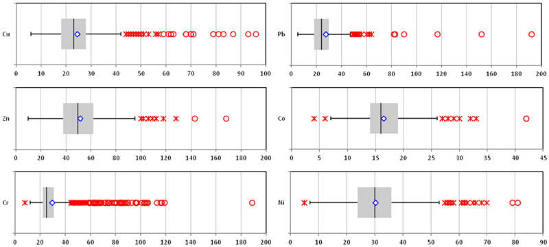
Box-whisker plots for Cu, Zn, Pb, Co, Cr and Ni distributions in stream sediments from Trindade–Chança region
Summary of descriptive statistics for distributions of Cu, Zn, Pb, Co, Cr and Ni abundances (ppm) in stream sediments from Trindade–Chança region
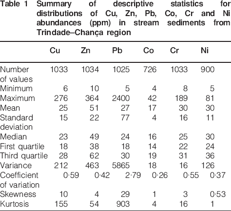
The Cu, Zn and Pb values in stream sediments from the Trindade–Chança region show some spread around their mean and median values, as indicated by their kurtosis values; this spread is much less notable for Co, Ni and Cr. However, with the exception of Pb, the data spread is not unusual with the coefficient of variation ranging from 0·26 to 0·59. Regarding Pb, the unusual coefficient of variation value (2·79) is explained by the presence of a number of outliers with values ranging from 80 to 2400 ppm Pb, the most important subset being discontinuously scattered in the interval 80–200 ppm. Consistent subsets of outlier values for Cu, Zn and Ni range 45–55 ppm Cu, 100–120 ppm Zn and 55–70 ppm Ni respectively, which cluster around 30 ppm for Co distribution. As for Cr, the anomalous subset spreads over the 40–120 ppm class of values, although showing a tendency to cluster along the 40–60 ppm concentration range. Similar conclusions can be drawn from an analysis of cumulative probability plots (Fig. 5). Pb and to some extent Cu and Cr have the most evident deviation from a normal distribution. All elements in the cumulative probability plots have outlier subsets. Slope changes and breaks indicating the existence of multiple populations in Ni, Co and Zn distributions constitute small portions (mostly upper tails) of the entire dataset. The Cu and Cr data deviation from normality is due to the significant (relative) weight of data making up the upper and lower tails in the corresponding distributions. Despite of all this information, the identification of threshold values (i.e. the upper and lower limits of the background) for each element distribution remains imprecise, therefore hindering anomaly separation in the correspondent geochemical maps. A different technique should then be used to objectively determine those threshold values.
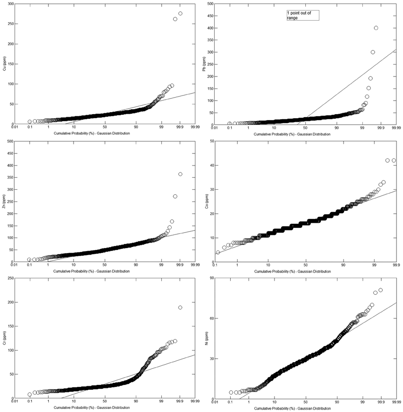
Cumulative probability plots for Cu, Zn, Pb, Co, Cr and Ni distributions in stream sediments from Trindade–Chança region
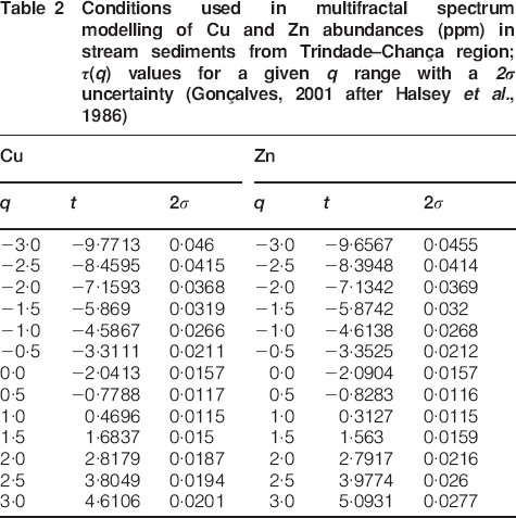
The multifractal character of Cu, Zn, Pb, Co, Cr and Ni content distributions in stream sediments of the Trindade–Chança region was modelled and the conditions used for Cu and Zn are shown in Table 2. All data sets display α−f(α) spectra consistent with a multifractal behaviour (Fig. 6), despite some (minor) deviations from typical curves. These deviations are due to two distinct causes: reduction of the spatial coverage of the sampling program due to the exclusion of samples with element contents below the analytical detection limit used and smaller set of sampled values for the α range considered in modelling, therefore producing an artificial dispersion along the first branch of the α−f(α) curve. Even so, the area concentration model can be used to calculate the (regional) threshold values for Cu, Zn, Pb, Co, Cr and Ni distributions; these are 20, 45, 30, 15, 22 and 25 ppm respectively. A first order local threshold value can also be calculated for all elements, delimiting anomalous Cu, Zn, Pb, Co, Cr and Ni contents above 40, 94, 70, 21, 37 and 42 ppm respectively (Fig. 7). These results are consistent with those derived from previous exploratory data analysis, being as well compatible with outcomes of soil geochemistry data analysis covering particular areas within the Trindade–Chança region (Luz, 2011).
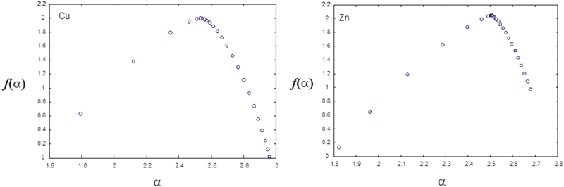
Representative α−f(α) spectra for Cu and Zn distributions in stream sediments from Trindade–Chança region
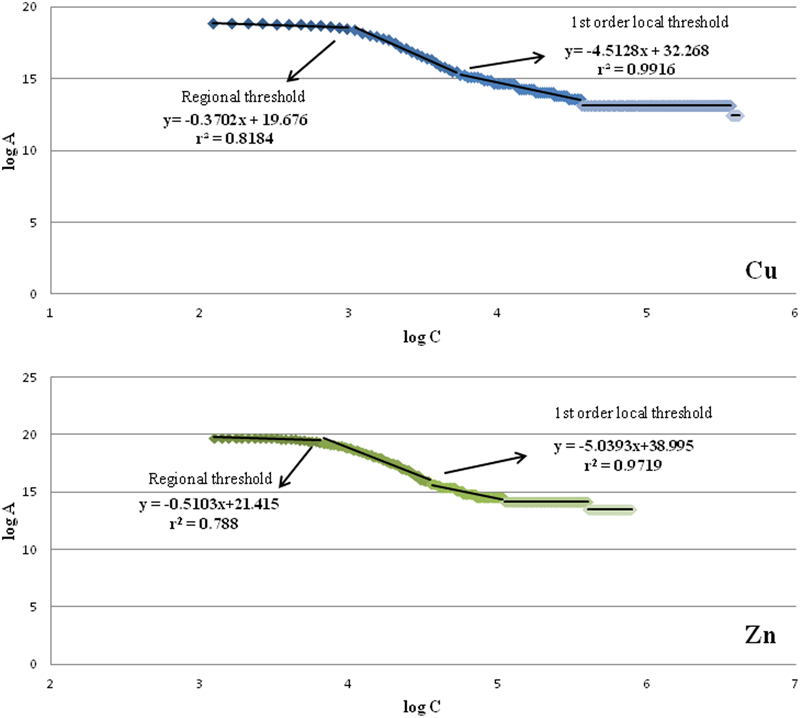
Representative log area–log concentration plots for Cu and Zn distributions in stream sediments from Trindade–Chança region.
Experimental directional variograms were computed and fitted to theoretical models, assessing the anisotropy ratio and orientation of the data. An exponential model fits all data sets reasonably well given the parameters for all elements (Table 3). For all distributions, optimised adjustments are obtained for directions ranging from WNW-ESE to NNW-SSE (settling the variogram anisotropy at 2 with a long axis orientation of 335° in azimuth), which is strongly consistent with the prevailing geological features observed in the Serra Branca–Chança region. The orientations of the kriged anomalies suggest the stream sediment geochemistry are related to proximal causes and also that the run-off characteristics of the region preserve the fundamental lithological geochemistry of potential sources, regardless of mixing during stream flow (not so significant along the second and third order fluvial tributaries).
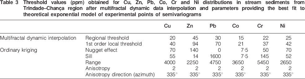
Threshold values (ppm) obtained for Cu, Zn, Pb, Co, Cr and Ni distributions in stream sediments from Trindade–Chança region after multifractal dynamic data interpolation and parameters providing the best fit to theoretical exponential model of experimental points of semivariograms
Geochemical (contouring) anomaly maps ( Figure 8 Figure 9 Figure 10 Figure 11 Figure 12 Figs. 8–13) were produced by ordinary kriging using the parameters described above. Contour maps were produced using only the values above the regional threshold calculated for each element to outline the anomalous areas. Concentration values obtained in each sample point were also charted in pixel plots for comparison purposes, giving as well a rough image of the source upstream within the basin catchment. The interpretation of the various anomalies was completed by comparing the geological information available for the Trindade–Chança region and after validation of the main (multi-element) anomalies in the course of several field surveys. The results show that the methodology followed in stream sediments data processing is adequate to compute threshold values and discriminate different types of anomalies, as further discussed.
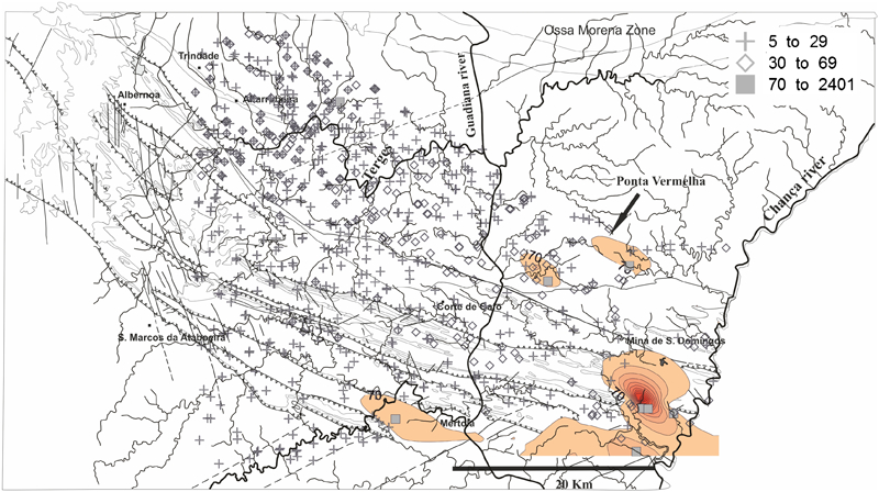
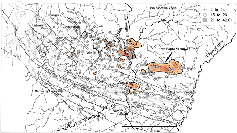
Pixel plot and contouring anomaly map (considering only the concentration values above the threshold values listed in Table 3) for Cu in stream sediments of the Trindade–Chança region. The pixel plot grouped the data into three classes of values (ppm): from the minimum value to the one immediately below the regional threshold calculated for each element, from the regional threshold to the value immediately below the first order threshold estimated for each element and above the first order threshold value. Lithological contacts (thin grey lines in background) and tectonic structures are displayed for reference to the geological map in Fig. 1
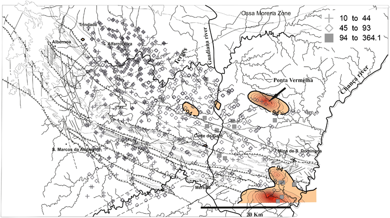
Pixel plot and contouring anomaly map (considering only the concentration values above the threshold values listed in Table 3) for Zn in stream sediments of the Trindade–Chança region. Classes of values used in the pixel plot defined as in Fig. 8. Lithological contacts (thin grey lines in background) and tectonic structures are displayed for reference to the geological map in Fig. 1
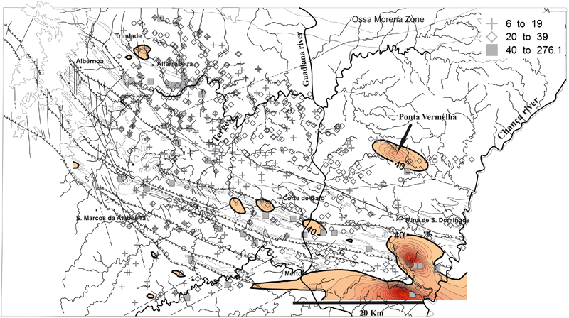
Pixel plot and contouring anomaly map (considering only the concentration values above the threshold values listed in Table 3) for Pb in stream sediments of the Trindade–Chança region. Classes of values used in the pixel plot defined as in Fig. 8. Lithological contacts (thin grey lines in background) and tectonic structures are displayed for reference to the geological map in Fig. 1
Pixel plot and contouring anomaly map (considering only the concentration values above the threshold values listed in Table 3) for Co in stream sediments of the Trindade–Chança region. Classes of values used in the pixel plot defined as in Fig. 8. Lithological contacts (thin grey lines in background) and tectonic structures are displayed for reference to the geological map in Fig. 1
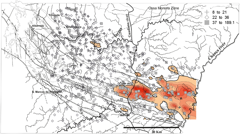
Pixel plot and contouring anomaly map (considering only the concentration values above the threshold values listed in Table 3) for Cr in stream sediments of the Trindade–Chança region. Classes of values used in the pixel plot defined as in Fig. 8. Lithological contacts (thin grey lines in background) and tectonic structures are displayed for reference to the geological map (Fig. 1)
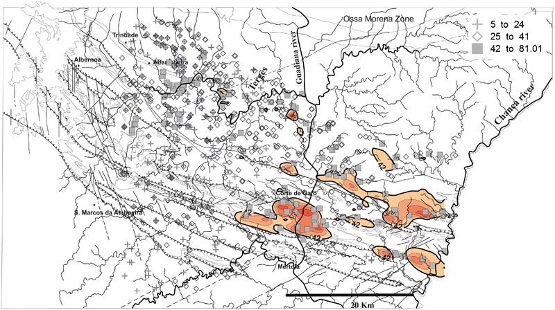
Pixel plot and contouring anomaly map (considering only the concentration values above the threshold values listed in Table 3) for Ni in stream sediments of the Trindade–Chança region. Classes of values used in the pixel plot defined as in Fig. 8. Lithological contacts (thin grey lines in background) and tectonic structures are displayed for reference to the geological map (Fig. 1)
Discussion
Geochemical anomalies put in evidence on the basis of Cu, Zn, Pb, Co, Cr and Ni contents in stream sediments distributed throughout the Trindade–Chança region are clustered to the E-SE of the area surveyed ( Figure 8 Figure 9 Figure 10 Figure 11 Figure 12 Figs. 8–13). The foremost control of these anomalies is not the flow along the main streams (Guadiana River and its primary tributaries, Terges and Chança). On the contrary, all the significant anomalies are regulated by dispersion mechanisms related to tributaries of those main streams, most of them having a conspicuous seasonal streaming regime. This strongly suggests that anomalous sites and contoured anomalies (above the regional threshold values previously calculated) are not significantly displaced from sources of the elements under study. Consequently, the geochemical anomalies identified in the Trindade–Chança region have a local source, and are similar to the results reported in Feliciano et al. (2008) after handling a wide (Cu, Zn, Pb and Co) data set of 4230 stream sediment samples covering the whole South Portuguese Zone and making use of the same technique. Indeed the regional threshold values computed for the Trindade–Chança region (20, 45, 30 and 15 ppm for Cu, Zn, Pb and Co respectively), with the exception of Pb, are of the same order of magnitude as the upper (regional) background threshold values for the South Portuguese Zone study (16±1, 45±1, 8±3 and 17 ppm, following the same order). The first order local threshold values, however, are lower than the regional scale study, which, although relatively ill-defined for some elements, were calculated by Feliciano et al. (2008) as 455±100 ppm for Zn and 83±3 ppm for Co, ranging between 1921 and 2465 ppm for Pb, and ∼1059 ppm for Cu.
The geochemical anomalies contoured in the Trindade – Chança region display also a moderate to strong anisotropy running E-W to WNW-ESE, occasionally developing oriented trails of isolated (smaller) anomalous areas. Some of the most expressive anomalies are quasi-centred in strong anomalous points; this is particularly evident for Cu and Pb, and in part for Cr. Considering the orientation of tributaries to which the geochemically anomalous stream sediments are related, as well as the run-off and flowing direction, different natural and anthropic causes can explain those observations as demonstrated by upstream catchment analysis and field evidence.
A simple inspection of the geological map covering the Trindade–Chança region shows that Cu, Zn, Pb, Co, Cr and Ni anomalies overlie the structurally and lithologically complex belt extending along the contact between the South Portuguese Zone and the PLT ( Figure 8 Figure 9 Figure 10 Figure 11 Figure 12 Figs. 8–13). The geochemical maps require higher density sampling grids than the one used in order to depict many of the lateral changes of rock types in this belt. The local character of these anomalies reflects mostly proximal sources from the surrounding geological formations. First order contributions that control the major Cr and Ni and minor Cu anomalies come from the volcanic rocks of the Gafo Fm. and the VSC which commonly display hydrothermal alteration. Erosional products from both the PQG and the BAFG may also be important contributors. The distribution of these lithologies appears to explain the distribution of major Cr and Ni anomalies, besides some minor and isolated Cu anomalies. Another potential source of the metals of interest may come from historic mining activities in the abandoned S. Domingos mine (Matos et al., 2006; Álvarez–Valero et al., 2008; Abreu et al., 2010; Mateus et al., 2011). Any contamination from historic mining activities will be dispersed by the S. Domingos stream (Chança river tributary) along the down-stream area that includes the Moitinha, S. Bento, Telheiro and Chumbeiro mine dams that are affected by acid mine drainage, and besides the old mine railway line to the Pomarão harbour at the Guadiana river. This dispersion explains the relative intensity and geometry displayed by multi-element (Cu, Zn, Pb±Ni) anomalies in the SE corner of the area surveyed. Another potential source for the anomalous stream sediment samples is the hydrothermal siliceous and carbonate mineralisation (often comprising disseminations of fine-grained sulphides) hosted by fault zones. This is the case for a local Pb anomaly overlapping the BAFG, as well as several isolated, minor Cu, Zn, Co and Pb anomalies sited within the Pulo do Lobo Fm. and running in a WNW-ESE direction. The most notable example of this epigenetic contribution is the occurrence of deformed calcite chlorite hydrothermal precipitates that are locally enriched in disseminated sulphides (mainly pyrite+pyrrhotite±chalcopyrite) at Ponta Vermelha which corresponds to a large multi-element (Cu, Zn, Pb, Co) anomaly. Within the Pulo do Lobo Fm, at the southern confluence of the Terges and Guadiana streams, there is a consistent Co anomaly that requires further investigation. This Co anomaly occurs within a coherent trend of minor Co and Cr anomalies which most likely correspond to erosion of mafic metavolcanic rocks similar to the Trindade unit exposed to the NW (whose south-eastern edge hosts the small Alfarrobeira Cu occurrence).
Conclusions
An irregular grid extending along the NE border of the South Portuguese Zone in Portugal, from Trindade to Chança, was used to collect 1034 stream sediment samples, which were analysed for Cu, Zn, Pb, Co, Cr and Ni. The element distributions for the elements deviate variably from a normal distribution and display a strong tendency to a multifractal behaviour. They also contain subsets of anomalous values that, for Cu, Zn, Pb, Cr and Ni are usually confined to the 45–55, 100–120, 45–60 and 55–70 ppm intervals, respectively, and ∼30 ppm for Co.
The threshold computation using the area–concentration multifractal model has proven to be a good approach in data handling, leading to consistent (multi-element) anomaly separation. The regional threshold values computed for the Trindade–Chança region of 20, 45, 30 and 15 ppm for Cu, Zn, Pb and Co respectively, are of the same order of magnitude as those for the upper (regional) background limit for the South Portuguese Zone study. The first order local threshold values for Cu, Zn, Pb, Co, Cr and Ni anomalies are 40, 94, 70, 21, 37 and 42 ppm respectively.
The geochemical anomalies are clustered to the ESE of the Trindade–Chança region and their local character reflect mixed contributions from: volcanic rocks included in the Gafo Fm., VSC and, to a lesser extent, from meta-sedimentary rocks belonging to the PQG; diverse products resultant from historic mining activities in the abandoned S. Domingos mine; hydrothermal mineralisation that occurs in various fault zones; and mafic metavolcanic rocks inter-bedded in the monotonous metasedimentary sequence that make up the Pulo do Lobo Fm.
Footnotes
Acknowledgements
LNEG is thankfully acknowledged for permission to use the data used in this study. The present work is a contribution of the METALTRAVEL (grant no. POCI/CTE-GEX/61700/2004) and PEst-OE/CTE/UI0263/2011 research projects funded by the Portuguese Agency for Science and Technology (FCT). We thank Dr Greg Partington and an anonymous reviewer for insightful feedback that strengthened the manuscript.