
Abstract
Abstracts from the 37th Annual Winter Meeting of the Geological Society's Mineral Deposits Studies Group held on the 6–7th January 2014 at the University of Oxford, UK. The meeting was hosted by the Department of Earth Sciences and Keble College. Sessions included: critical metal supply – a global perspective; exploration in difficult times; the mineral industry – challenges in the 21st century; Ore deposit research in progress; and Metallogeny of new jurisdictions.
Geology and geochemistry of granites associated with rare metal-bearing pegmatites, Ijio area, SW Nigeria
A. Abdurrahman, J. C. Ø. Andersen, B. J. Williamson.
University of Exeter – Camborne School of Mines, Penryn, Cornwall TR10 9EZ, UK (aa460@exeter.ac.uk)
A surge in global demand for rare metals, mainly for uses in high-tech electronic devices and low-carbon energy production, has intensified exploration for these strategically important commodities. Pegmatites in the Ijio granites, south-west Nigeria, are known to contain tin–niobium–tantalum–zinc mineralisation and gem pockets which until recently have been little studied. The granites and pegmatites were emplaced into gneisses and metasediments of the Pan-African Basement Complex at ca 600 Ma (Grant, 1970). They are texturally diverse, ranging from fine-grained, to medium grained biotite granites, porphyritic granites and granodiorites. They generally contain perthitic microcline as well as biotite and muscovite and lesser amounts of hornblende, apatite, monazite, tourmaline, garnet, rutile and magnetite.
From major and trace element studies, the granites are metaluminous to peraluminous, and calc-alkaline to alkaline. They are moderately to highly enriched in Li (18 to 93 ppm), Be (12 to 243 ppm), Rb (24 to 369 ppm), Cs (5 to 33 ppm), Nb (4 to 37 ppm), but they generally contain low Ta (2 to 6 ppm). Total REE abundances range from 63 to 300 ppm, and La/YbN from 6·59 to 32·21. Their REE patterns are highly enriched in the LREE but are relatively depleted in HREE, and they have moderate to strongly negative Eu anomalies. They also generally have low Yb (<2 ppm) and relatively high Sr (>400 ppm). From these characteristics the granites are likely to be relatively evolved, which is supported by high average ratios for K/Cs = 3746; K/Rb = 310; Rb/Cs = 12 and Nb/Ta = 3.
The mineralogy and geochemistry of the granites is similar to granites in the Precambrian basement complex of south-west Nigeria. However, their petrographic and chemical variations, and the production of pegmatites, are inferred to have resulted from extreme fractional crystallisation. Studies of the mineral chemistry of the granites, and their relations to the pegmatites, are ongoing, which is essential in the development of exploration models for different rare metal mineralisation in the Ijio granites, particularly for Li, Ta, Nb and Sn.
CRIRSCO modifying factors – a guide for exploration and resource geologists
R. E. Allington 1, 2.
1Honorary Treasurer, PERC
2Joint Senior Partner, GWP Consultants LLP, Upton House, Market Street, Charlbury, Oxfordshire, OX7 3PJ, UK (rutha@gwp.uk.com)
All of the codes and standards for reporting resources, reserves and exploration results in the CRIRSCO (Committee for Mineral Reserves International Reporting Standards) family include identical definitions, which are represented on the following diagram.
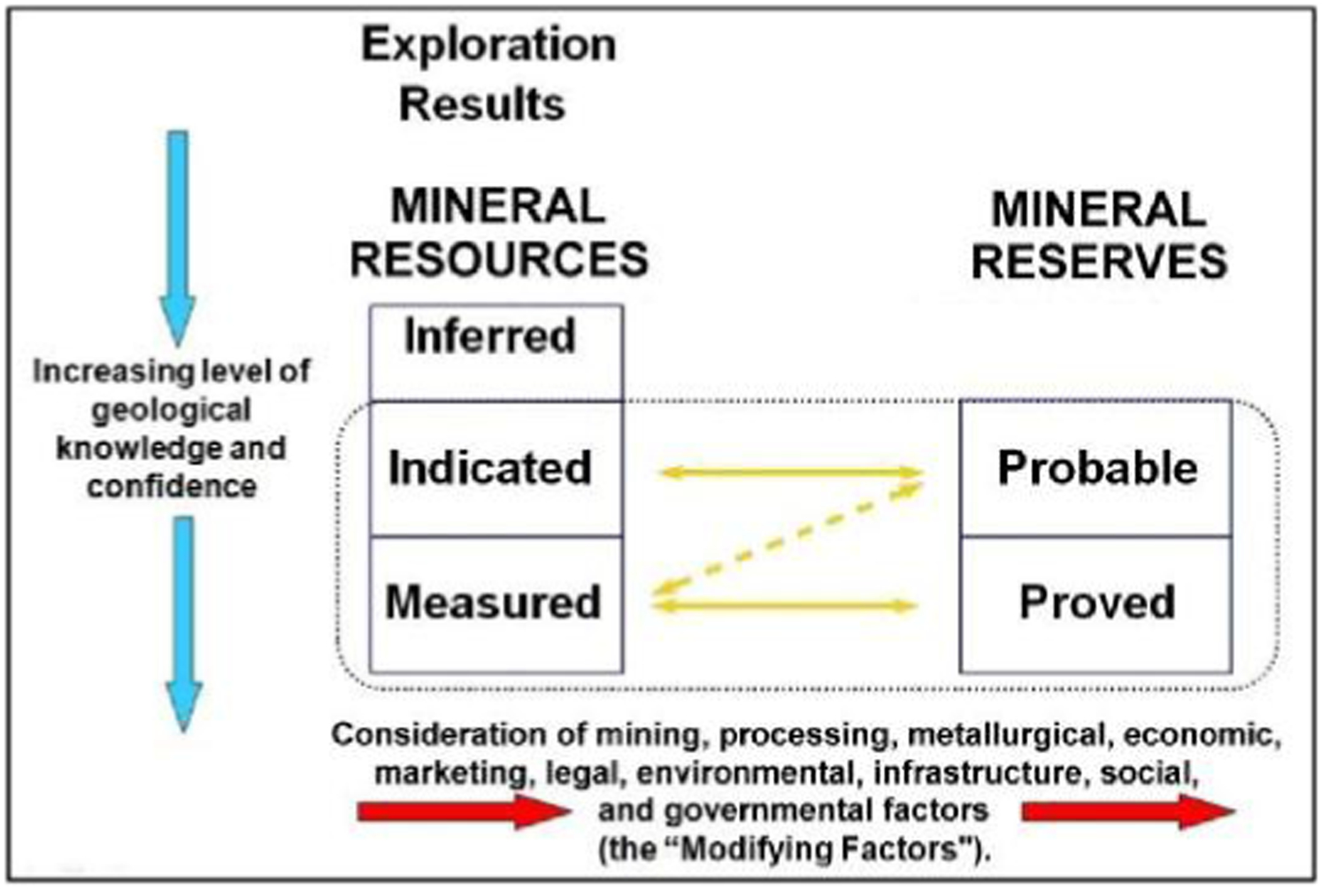
Progression from inferred to measured resources is primarily the province of geoscientists and is all about reducing uncertainty regarding the quality, recoverable quantity and continuity of the minerals. The CP responsible for public reporting of resources is likely to be an exploration or resource geologist. The exploration and resource geologists may not have much experience or expertise pertaining to the ‘modifying factors’ and may consider that such things are really nothing to do with them.
Working with the modifying factors to establish technical feasibility, minimise environmental impact and ensure economic viability is often considered to be a distinct stage in the evaluation of a deposit and planning of a mine or quarry, completely separate from the exploration and modelling of the deposit itself. These activities typically involve many professionals including engineering, production, processing, environmental assessment, operations, legal and financial specialists. There may be one Competent Person taking overall responsibility for co-ordinating the team and bringing together the reporting or there may be several, each taking responsibility for their own discipline area.
This contribution will present a holistic and iterative open pit design process developed for the planning and design of open pit mines and quarries for construction materials and industrial minerals (GWP, 2008) that aim to strike the balance between social, economic and environmental factors commonly referred to as sustainability. The approach is based not only on ensuring that the right team is assembled but also that ‘modifying factors’ are considered at every stage of the process, including during exploration and resource evaluation activities. Anticipating which of the modifying factors will be important in eventually proving reserves can save time and money (e.g. by undertaking non-geological data collection and establishment of long term monitoring when exploration and other geological field work is underway). This approach is also conducive to supporting public participation and achieving a social licence to operate.
Geology and metallogeny of the Charsk-Gornostaev ophiolite belt, East Kazakhstan
B. Amralinova 1, B. Dyachkov 1, A. Dolgopolova 2.
1East Kazakhstan State Technical University (EKSTU), Ust-Kamenogorsk, Kazakhstan (Bakytzhan_80@mail.ru)
2NHM, Department of Earth Sciences, CERCAMS, London, UK
East Kazakhstan is one of the most important mining areas in Kazakhstan. Strengthening of mineral resource base for mining enterprises is important for the region that includes geological structures of the Greater Altai. The Greater Altai was formed after a collision of Kazakhstan and Siberian continents, which were separated by the Irtish-Zaisan palaeobasin in Devonian-Early Carboniferous. The Zaysan suture was formed as a result of this collision (Dyachkov et al., 2009). The zone is presented by the Charsk and West Kalba structural zones framed by deep faults. The Zaisan suture is bordered by the Kalba-Narym terrane in NE along the Terekty-Ulungur deep fault, whereas in SW of the Zharma-Saur terrane it is separated by the Bayguzina-Bulak fault. The Charsk-Gornostaev ophiolite belt is traced in its axial part indicating a mantle deep fault zone (thrust fault) or a tectonic suture (Dyachkov et al., 2009).
Palinspastic reconstruction of geological structures of the Greater Altai allows reconstructing a geodynamic development of the Zaysan suture zone as follows. The Charsk-Gornostaev ophiolite belt was formed during the Hercynian collision. This is a major arc-shaped suture of regional importance that is delineated by the Gornostaev and Charsk thrusts. The belt is traced for more than 500 km, i.e. from the Kulunda basin (in the NW) to the Zaisan lake (NE) and then continues into China. In NW flank (south of Semipalatinsk) the belt underwent a strike-slip displacement along the Znamensk sub-latitudinal fault with the amplitude of 25–30 km (sinistral shift), and at this place it is divided into two branches – Gornostaev (meridional) and Charsk (NW).
Isotopic data of zircons from garnet-amphibolite schists identified the age of ophiolites as 457–486 Ma. The average zircon age (16 analyses) from amphibolites of the Nizkobarich complex corresponds to the Early Silurian age of 436·5 Ma. In summary, all age data of metamorphic rocks from the Charsk ophiolite belt published in recent years correspond to the Caledonian cycle.
Precambrian cycle is characterised by the occurrence of small deposits and occurrences with primary Cr, Ni, Co, Cu mineralisation (Andreev, Suuk-Bulak, etc.). Caledonian formations of the Charsk zone are represented by olistostrome blocks and plates welded by a serpentinite melange. Ages of reef limestones are O-C1, and O-S1 for metamorphic rocks (Ermolov, 2013) Formations of the Hercynian cycle are represented by basalt-andesite, calc-siltstone (Arkalyk S1v2-3) and graywacke olistostromes (Aganaktin C1s) formations. During the Early Cimmerian cycle there are manifestations of alkaline magmatism (trachybasalt-trahirhyolite volcano-plutonic formation), whereas weathering crusts deposits of Ni–Co, Ti–Zr and Au (Belogorsk, Karaotkel, Janan) were formed in Late Cimmerian.
A number of Co–Ni deposits have been explored within the Charsk branch of the ophiolitic belt; these deposits are spatially and genetically related to the weathering crust developed over serpentinised hyperbasites. Approved reserves of Ni and Co of the Gornostaevskoe and Belogorskoe deposits are 130 and 140 thousand tonnes, respectively, grades NiO 0·5–6·7%, Co up to 0·2%. These deposits can be used for production of Co, Ni, Fe, refractories, fertilisers and natural dyes.
Alteration stages in the Nalunaq Gold Deposit, south Greenland
R. M. Bell 1, 2, J. Kolb 1.
1Geological Survery of Denmark and Greenland (GEUS), Øster Volgade 10, 1350 K København (rmb@geus.dk)
2Depertment of Geosciences and Natural Resource Management, Copenhagen University, Denmark
Nalunaq gold deposit is located on the southern tip of Greenland, in the Ketilidian Orogen, close to the Julianehåb Batholith (Kaltoft et al., 2000). The area is the site of Greenland's only producing mine, due to close end 2013 (http://angelmining.com/). The deposit is characterised by narrow gold-quartz veins and exceptionally high gold grades (up to 5000 g t–1) (Kaltoft et al., 2000), hosted in amphibolite facies meta-basalts and meta-dolerites. Nalunaq gold deposit is thought to be part of a larger regional gold district, as indicated from stream sediment samples and additional discoveries of gold-quartz veins within Nanortalik Pennisula (Kaltoft et al., 2000; Roybn, 1993). Previous studies have been impaired by the assumption that all alteration was of one stage and confusion regarding an alteration halo associated with the gold-quartz vein (Kaltoft et al., 2000; Porritt, 2000). A greater understanding of the structural and petrological constraints on gold deposition at Nalunaq will potentially aid in the discovery of further deposits in the area and allow for more focused gold exploration.
This study has revealed the formation of an early regional skarn alteration, unrelated to gold mineralisation, consisting of garnet, plagioclase, diopside±chalcopyrite±pyrrhotite. The source for this alteration may be the Julianehåb Batholith. Gold-quartz veins cross-cut the skarn, trending 35°50°, SE. Non-mineralised quartz-calcite veins contemporaneous with gold mineralisation are orientated at angles 70–90° to the gold-quartz veins. A narrow (5–20 cm) alteration halo of biotite, arsenopyrite, rutile±tourmaline surrounds the gold-quartz vein. A retrogressive overprint defined by zoisite±chlorite±muscovite±pyrite±hematite replaces earlier alteration stages. A regional-scale epidote-calcite±feldspar alteration cross-cuts all alteration stages within the Nalunaq gold deposit. The source of the final alteration stage is theorised to be either fault or skarn related. A later suite of rapakivi granites are a potential source provided the final stage is skarn related.
This study revealed a minimum of four separate alteration assemblages, both pre- and post-dating gold mineralisation. Both orogenic-type and intrusion-related alteration is present and both contain sulphides, though only the orogenic-type is mineralised. The mineralogy of the separate alteration stages indicate that peak metamorphism occurred during the formation of the first skarn alteration and gold deposition occurred post-peak. The mineralogy of the alteration halo surrounding the gold-quartz vein may be used as a vector in the discovery of further high-grade gold deposits. The previously used vector, calc-silicate alteration, is ineffective as this includes the regional skarn, which is not associated with gold mineralisation.
The paragenesis of sulphides in the Pb–Zn–Ag–Ba deposit at Triades, Milos, Greece
S. H. Bicknell 1, D. J. Smith 1, J. Naden 2.
1Department of Geology, University of Leicester, Leicester LE1 7RH, UK (shb11@student.le.ac.uk)
2British Geological Survey, Keyworth NG12 5GG, UK
With the predicted increase in demand for both base and precious metals (Hatch, 2012), the exploration of submarine deposits is becoming increasingly of interest to the mineral extraction industry (Baker et al., 2012). Existing studies (Baker et al., 2012) in this field have largely been through the use of bathymetry and autonomous underwater vehicles to target areas for marine sampling. This focuses on the recognition and exposure of the necessary structures, and the presence of mineralisation or favourable indicators in recovered samples. This is an expensive process and the understanding of submarine deposits remains in its infancy. This study focuses on Triades, a 1·5 to 2·4 Ma (Baker et al., 2012) submarine deposit on the island of Milos which has been exposed on land by relative sea level change, as an analogue for submarine hydrothermal mineralisation.
The mineralisation at Triades is largely of massive galena veins, containing the majority of the Pb (Marschik et al., 2010), with minor sphalerite and pyrite viewable in hand specimen. This is hosted in brittle faults within a heavily baritised breccia, often showing evidence of repeated or continuous deposition of minerals (largely barite and quartz) from hydrothermal fluids. The mineral deposition appears to be in at least two stages: a sulphide dominated phase with some barite deposition and a separate barite–dominated phase with minor disseminated sulphides in some areas; which is supported by experimental testing on the fluid system by Christanis and Seymour (1995) and by isotope analysis by Marschik et al. (2010). If the change in deposition can be better understood, this could potentially give insight into the ore forming processes in other deposits composed of a combination of seawater and magmatic fluid.
Using a combination of field observations, extensive reflected light and SEM microscopy, the ore textures and paragenesis will be ascertained and compared against current models to create a robust fluid model for the mineralisation at Triades. From the variations in mineralogy and textures, a cause for the changes in deposition will be assessed this will allow changes in fluid and environment to be ascertained. From the insights gained into the fluid and environment of deposition, this research aims to create a better understanding of submarine hydrothermal systems and also how Triades may be linked to other submarine hydrothermal deposits on Milos such as the epithermal gold silver deposits of Profitis Ilias, and the microbially mediated manganese oxide deposit at Cape Vani (Marschik et al., 2010).
The Kibali ‘orogenic’ gold deposit, NE Democratic Republic of the Congo; investigation of a world class gold resource
P. J. Bird 1, P. J. Treloar 1, C. A. Vargas 2, P. Harbidge 2, A. J. Boyce 3.
1Kingston University, Penrhyn Road, Kingston upon Thames, Surrey KT1 2EE, UK (pjbird@kingston.ac.uk)
2Randgold Resources Ltd, 3rd Floor, Unity Chambers, 28 Halkett Street, St Helier, Jersey JE24WJ, UK
3Scottish Universities Environmental Research Centre, Scottish Enterprise Technology Park, East Kilbride G75 0QF, UK
The Kibali orogenic gold deposit is one of the most significant gold projects under development in the world today. Located in NE Democratic Republic of Congo the principle deposit, the KCD, contains an inferred resource of 13·9 Moz Au (December 31, 2012), with a series of satellite deposits, Mengu, Pakaka, Pamao, each containing between 0·3 and 1·2 Moz Au and offering significant upside potential and a total inferred resource of 18·9 Moz Au (December 31, 2012). The characteristics of the host greenstone belt are addressed in a companion poster presentation.
Gold mineralisation occurs within the KCD, as three stacked NE dipping tabular lodes hosted by heavily altered volcano-sedimentary agglomerate within the Neo-Archaean Kibali Granite-Greenstone terrane. Lodes are laterally confined by large vertical shears (S2) which bisect the host greenstone belt dividing it into a series of mineralised corridors. Several significant satellite deposits sit within these adjacent mineralised corridors with the largest, Mengu, Pakaka and Pamao currently under development. The satellite deposits share the same morphological characteristics though each consists of a single dipping lode. The KCD deposit consists of disseminated sulphides hosted in quartz vein structures. Pyrite, arsenopyrite, chalcopyrite and pyrrhotite are the dominant sulphide phases with multiple generations of each identified. Gold is principally associated with the pyrite 2 phase occurring both as rounded sub-micrometre to millimetre size occluded particles and as native gold. The satellite deposits possess the same range of sulphide minerals identified within the KCD, although proportions can vary significantly between deposits and within individual deposits. The Mengu deposit is dominated by pyrite with only minor occurrences of other sulphides while Pakaka and Pamao possess zones significantly enriched in arsenopyrite. Despite these variations pyrite 2 remains the most abundant phase and shows the strongest correlation with Au mineralisation. 34S data from the KCD and satellite deposits has shown that deposits are internally heterogeneous although all deposits have a similar spread of 34S data ranging from −2 to +8‰ with an average of +4·4‰. Several distinct alteration events have been identified within the host rock at the KCD and surrounding satellite deposits. Texture destructive silica (S1) is overprinted by ankerite (A1), both phases ranging from poorly developed, distal to mineralised zones, to texture destructive proximal to the mineralisation. Mineralised micro-veins cut these phases remobilising S1 and A1 to produce coarser silica (S2) and ankerite (A2) which host the mineralised sulphide phases. Compositional analysis has shown the later S2 and A2 phases to be similar to the finer early texture destructive S1 and A2. Late alumina-celadonite (M1) and chlorite (C1) alteration form minor phases with concentrations common along the interface between S1/A1 and S2/A2 zones.
The deposits show a strong spatial association with the intersection of NE dipping thrust faults (S1), which parallel the attitude of the principle lodes, and the late S2 semi-brittle shears that cut through the deposits acting as a focus for mineralisation. We consider these faults to have acted as fluid pathways and focusing mechanisms for a region wide homogenous gold bearing fluid sourced from metamorphic devolatilisation within a thickening thrust stack.
The Kibali granite-greenstone terrane, NE Democratic Republic of the Congo; characterising a new gold bearing terrane
P. J. Bird 1, P. J. Treloar 1, C. A. Vargas 2, P. Harbidge 2, I. L. Millar 3.
1Kingston University, Penrhyn Road, Kingston upon Thames, Surrey KT1 2EE, UK (pjbird@kingston.ac.uk)
2Randgold Resources Ltd, 3rd Floor, Unity Chambers, 28 Halkett Street, St Helier, Jersey JE24WJ, UK
3NERC Isotope Geosciences Laboratory, Kingsley Dunham Centre, Keyworth, Nottingham NG12 5GG, UK
The Kibali orogenic gold deposit is one of the most significant mining projects under development in the world today. Located in NE Democratic Republic of Congo the project has a total inferred resource of 18·9 Moz Au (December 31, 2012) making it the largest African gold deposit outside of South Africa. Despite gold having been worked in the region as far back as 1906 the Kibali greenstone belt has remained largely underexplored and unresearched until recently. The discovery and development of the giant Kibali gold deposit has revealed the potential for the greenstone belts in the NE DRC to host significant mineralisation, stimulating further exploration and allowing academic research to begin. The deposit characteristics are outlined in an accompanying presentation.
The Kibali study area straddles three geological terranes. From the North these are: the Kibali granite-greenstone belt, the West Nile Gneiss and the Upper Zaire Granitoid Massif. The Kibali granite-greenstone terrane is an east-west trending elongate belt, consisting of thrust stacked volcano-sedimentary units, carbonaceous shales, banded iron formations and sub aerial basalts. These units are intruded by numerous plutons ranging in composition from granitic to gabbroic. U–Pb zircon dating of a number of granitoids shows them to be Neo-Archaean (2·6 Ga). Metamorphic grade is variable across the belt, increasing progressively from sub-greenschist facies in the west to amphibolite facies in the east. The Upper Zaire Granite Massif dominates the southern edge of the study area. Here the Watsa Igneous complex displays a range of rock types with a gabbroic core ringed by granodiorite and granite intrusions with sub-arial basalts cropping out along the NW edge of the complex. U–Pb zircon dating places the complex as Neo-Archaean (2·6 Ga). Trace element data indicate a possible common origin with the intrusive units within the greenstone belt to the north. The West Nile Gneiss is thrust southward over the Kibali granite-greenstone terrane and is dominated by granitic gneisses (quartz-plagioclase-mica) though the degree of foliation is highly variable along its length. Two major structural components have been identified in the Kibali granite-greenstone belt. Early ductile, NW–SE trending NE dipping thrust faults (D1), dominate a fold and thrust terrane that includes south-vergent recumbent folds. A later set of sub-vertical NE–SW semi-brittle shear structures (D2), deform and re-folding the earlier structures.
Gold deposits have so far only been identified within the Kibali granite-greenstone terrane with the West Nile Gneiss and Upper Zaire Granite currently considered barren. The main Kibali deposit and the largest satellite deposits are located at the western end of the terrane within the greenschist facies volcano-sedimentary agglomerates. Their location is controlled by the sub vertical D2 shears.
We hypothesise that the gold resource formed in a convergent tectonic environment as part of a thickening thrust stack along the edge of the forming Upper Zaire Granitic massif. Devolatilisation of the lower stack generated fluids which ascended upwards along faults, scavenging sulphur and metals. The formation of the S2 semi-brittle shears is thought to have ‘shattered’ the rock, providing a fluid conduit and enabling deposition within the favourable volcano-sedimentary horizon.
Mineralogical and fluid characteristics of Arzu North and the association to Arzu South in the Kiziltepe prospect, Balikesir, Western Turkey
D. E. Blanks 1, D. A. Holwell 1, I. Van Coller 2.
1Department of Geology, University of Leicester, LE1 7RH, UK (db261@le.ac.uk)
2Ariana Resources plc., Galata Madencilik, Balikesir Cad., Sindirgi, Balikesir, Turkey
Arzu North and South are economic auriferous veins of the Kiziltepe Au–Ag deposit in the Sindirgi district, Balikesir, Western Turkey. Kiziltepe is a low-sulphidation epithermal system, part of the Red Rabbit Gold Project, located in the Sindirgi Gold Corridor, a province which is host to other epithermal and porphyry intrusion related Au deposits. A recent study characterising the mineralogy and fluid characteristics of Arzu South has been carried out by Yilmaz et al. (2012). It appears that the Arzu North and Arzu South vein systems are developed within the same NW-trending structural corridor, although recent X-ray fluorescence soil geochemistry suggests that the Arzu North veins evolved differently to those at Arzu South.
The veins at Arzu North trend NW–SE; are steeply dipping; show crustiform/colloform banding of chalcedony and quartz; lattice blading; quartz pseudomorphing platy calcite; and bonanza grade sulphide-rich ginguro mineralisation. The deposit is hosted by Early Miocenic dacitic–andesitic volcanic and pyroclastic formations (Seyitoglu, 1997) that are part of the Western Turkish magmatic arc complex associated with the post-collisional, North–South compressional event in the Early Eocene due to the movement of the African Arabian plate (Dilek and Altunkaynak, 2007). This complex is comprised within the Tethyan Eurasian Metallogenic Belt of the Alpine-Himalayan orogenic system (Yigit, 2006; Yilmaz et al., 2012).
Initial mineralogical work, including 3D CT analysis, carried out on Arzu North has identified four styles of mineralisation: (i) Au and Ag sulphide as clusters in quartz (ginguro spots); (ii) Au and Ag sulphides bands on the margin of quartz and chalcedony patches; (iii) Au and Ag sulphides along the lattice of bladed quartz; and (iv) Ag sulphides and pyrite in altered wall rock. Gold is present in all mineralisation stages occurring as electrum along quartz fractures, Au-rich acanthite and uytenbogaardtite (Ag3AuS2) as exsolutions of acanthite. Silver is present as acanthite in all stages and as proustite and Ag–Sb–As–Cu sulphide in style 1. Mineralisation style 4 is deficient in Au whilst Ag is present as acanthite, cuperous-stephanite, and as inclusions in pyrite.
The mineralisation styles present implies an evolving or episodic fluid, and a more complex mineralisation history than Arzu South. Fluid inclusion microthermometry from Arzu North is currently testing the source and evolution of the fluids and will be compared to results from Arzu South which identified three main fluid phases (Yilmaz et al., 2012).
Structural controls on the distribution of polymetallic mineralisation of Southern Tuscany, Italy
S. Boffey-Rawlings 1, G. R. T. Jenkin 1, D. James 2, G. Cryan 2.
1The University of Leicester, University Road, Leicester LE1 7RH, UK (sb496@le.ac.uk)
2Medgold Resources Corp., 200 Burrard Street, Vancouver, BC, V6C 3L6, Canada
Mineralisation in Southern Tuscany is rich and diverse; with historical mining of pyrite, iron, base metals, mercury, antimony and silver. More recently, gold mineralisation has been identified (Tanelli, 1983). This diversity of mineralisation is largely a result of the tectonic history of the area being located in the inner zone of the Northern Apennines. This belt is the result of collision between the European and African continental margins and crustal thickening at the Oligocene–Miocene boundary (Brogi and Fulignati, 2012). From Pliocene to Recent, as the compression front of the Apennines migrated to the east, Southern Tuscany underwent crustal thinning and mantle doming (Lattanzi, 1999). Following compression, a phase of extension generated a series of high-angle normal faults, contemporaneous to granitoid emplacement (Brogi and Fulignati, 2012); a current source of geothermal energy in the geothermal fields of Larderello, Amiata and Latera.
Medgold holds three exploration licenses in SW Tuscany, all of which are early-stage projects. Gold was discovered in Italian deposits in the 1980s and is thought to be controlled by late-orogenic ‘Apennine’ (NW–SE) or ‘anti-Apennine’ (E–W) normal faults, previously known for Sb deposits associated with horst structures produced by block-faulting extensional tectonics (Lattanzi, 1999).
The objective of this project is to better understand the structural controls on mineralisation in and surrounding the Colline Metallifere (‘Metal Hills’). The objective is to increase the understanding of the controls on mineralisation in Tuscany. The study area covers approximately 315 km2 and includes numerous abandoned polymetallic mines. Structural measurements of veins, joints and bedding across the width of Southern Tuscany, were collected in the field. This primary data has been used, together with secondary data collected from a variety of literature sources, to better understand the link between the local geology, mineralisation and faulting.
Using Arc GIS, the primary data set is plotted along with all available spatial data, including geological maps and old mining maps, which have been produced by various mining companies. Faults observed by previous authors, inferred faults from analysing hill shades and patterns in topography are being collated. This enables firstly analysis of the conditions that have allowed this particular mineralisation, and secondly investigation of locations with similar setting.
In order to understand the relationships further, 3D analysis will be undertaken using Micromine to establish orientation as well as dip of faults and possible intersections. The stratigraphical relationship will also be examined to investigate if there is a preferred host rock for mineralisation. By moving to a 3D image, cross and long sections of borehole data generated by mining companies can be integrated to establish the relationship between mineralisation and faulting.
Structural model creation: The impact of data type and creative space on geological reasoning and interpretation and the uses of 4th dimensional modelling
C. Bond 1, G. Johnson 2, J. Ellis 3, A. Vaughan 3.
1School of Geosciences, Meston Building, Aberdeen University, UK
2Scottish Carbon Capture and Storage, The University of Edinburgh, Edinburgh, UK
3Midland Valley, 144 West George Street, Glasgow G2 2HG, UK (jenny@mve.com)
Interpretation of sparse or incomplete datasets is a fundamental part of geology, particularly when building models of the subsurface. Available geological data are often remotely sensed (seismic data) or very limited in spatial extent (borehole data). Understanding how different datasets are interpreted, and what makes an interpreter effective, is critical if accurate geological models are to be created.
We designed a study to compare the outcome and techniques used by two cohorts of interpreters of different geological datasets of the same model (Fig. 1), based on an inversion structure. The first cohort consisted of interpreters of the synthetic seismic image data in Bond et al. (2007); the second cohort was new and interpreted borehole data.
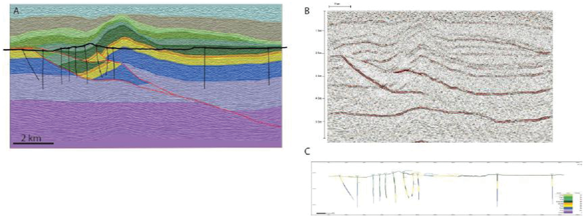
Geological model and datasets used in the interpretation exercise. (A) Original geological model, shown transparently coloured by stratigraphic unit, faults in red; behind this is the synthetic seismic created from the model interpreted by cohort 1. The black lines show a topographic surface and 11 boreholes used to create the dataset for cohort 2. (B) Synthetic seismic dataset shown as presented for interpretation by cohort 1. (C) The borehole and topographic data as presented by cohort 2
The outcomes of the borehole interpretation dataset support the findings of Bond et al. (2012). They show that concurrent use of several techniques, and specifically those that show evidence of geological evolution thought processes (fourth dimensional modelling), results in more effective interpretation. The results also suggest that the borehole interpreters were more effective at arriving at the correct interpretation. Analysis of the final interpretations in the context of psychological and medical image analysis research suggests that the clarity of the original dataset, and the amount of noise and white space, may play a role in interpretation outcome, by channelling geological reasoning during data interpretation.
Geochemical and mineralogical characteristics of Au mineralisation in the Pb–Zn–Ag Balya mine, NW Turkey: A separate mineralisation system?
M. J. Booth 1, D. A. Holwell 1, R. J. Siddle 2, T. Kaskati 3.
1Department of Geology, University of Leicester, University Road, Leicester LE1 7RH, UK (mjb77@student.le.ac.uk)
2MICROMINE United Kingdom, Challoner House, 19 Clerkenwell Close, London EC1R 0RR, UK
3Eczacıbaşı Esan LTD, Istanbul Leather Industrial Estate, Bolgesi, Kazlicesme, Road Number: 35 34956, Tuzla/Istanbul, Turkey
The Tethyan Metallogenic Belt, extending from Europe through Anatolia to Iran, is one of the world's major metal producing belts. Mineral deposits of the Biga Peninsula in north western Turkey exhibit, in many ways, mineral deposits characteristic of those found throughout the belt (Yigit, 2012). Epithermal Au–Ag deposits, porphyry Au–Cu–Mo and base-metal skarn systems are economically the most important.
The Balya Pb–Zn–Ag deposit is located 30 km NW of the city of Balikesir in the Biga Peninsula, NW, Turkey and is currently mined by Eczacıbaşı Esan. The deposit hosts skarn-type mineralisation and is one of the many epigenetic Pb–Zn deposits in the Biga Peninsula (Yigit, 2012). However, the deposit is also well endowed with Au mineralisation which is poorly understood. This study focuses on the characteristics and timing of the Au-mineralisation in relation to the Pb–Zn–Ag mineralisation.
Balya is historically classified as a skarn deposit, but contains minor disseminated and vein type mineralisation (Ozisik, 2009). Skarn type mineralisation occurs in the contact area between the Permian limestones and Cenozoic calc-alkaline dacites and andesites, producing wallrocks displaying strong skarn style calc-silicate and hydrothermal argillic alteration (Ozisik, 2009). The mineralisation is strongly structurally controlled by a steeply dipping normal fault.
Initial mineralogical studies show Au mineralisation is spatially heterogeneous within four different mineralogical associations: (i) a blebby pyrite-chalcopyrite with a finer sphalerite groundmass and minor galena; (ii) a massive chalcopyrite–pyrrhotite stockwork showing brecciation of the host rock; (iii) a fine grained pyrite assemblage with quartz veins 1 mm in diameter; and (iv) a disseminated pyrite assemblage with quartz veins 3 mm in diameter within a vuggy host rock.
A comprehensive precious metal study is being undertaken. Initial results show Au as electrum is associated with lillianite (Pb3Bi2S6) as inclusions within sphalerite in mineralisation style 1. Matildite (AgBiS2) is associated with bismuthinite (Bi2S3) in the same mineralisation style. This Ag–Bi–Pb sulphosalt association with gold and silver may give evidence of the melt scavenging effect named the Liquid Bismuth Collector Model (Douglas et al., 2000), which would imply temperatures of around 300°C or above.
The mineralogical relationships are similar to those observed by Cockerton and Tomkins (2012) at the Stormont Au skarn prospect, NW Tasmania, where the liquid Bi collector model is thought to be responsible for Au concentration. In contrast, the mineralisation style 2 contains Au as electrum with no association with Bi-sulphosalts and is instead associated with pyrrhotite.
Sulphur isotope analysis of the sulphides together with detailed paragenetic work are currently being undertaken to determine the timing of the Au mineralisation styles and help to constrain a genetic model to apply to Au exploration in the region.
The origin of the Sakatti Cu-rich magmatic Cu–Ni–PGE deposit, northern Finland
W. Brownscombe 1, 2, R. J. Herrington 1, J. Wilkinson 2, J. Coppard 3, C. Ihlenfeld 4, A. J. Boyce 5, I. MacDonald 6.
1LODE, Natural History Museum London, Cromwell Road, London SW7 5BD, UK (william.brownscombe@seh.oxon.org)
2LODE, Department of Earth Science and Engineering, Imperial College London, London SW7 2AZ, UK
350 Chapel Lane, Letty Green, Hertford SG14 2PA, UK
4Anglo American Exploration, 20 Carlton House Terrace, London SW1Y 5AN, UK
5SUERC, Rankine Avenue, Scottish Enterprise Technology Park, East Kilbride G75 0QF, UK
6School of Earth and Ocean Sciences, Cardiff University, Main Building, Park Place, Cardiff CF10 3YE, UK
The Sakatti deposit is a greenfield discovery in northern Finland. The deposit consists of both disseminated and massive Cu–Ni–PGE mineralisation hosted by an olivine cumulate. The deposit has a conduit-like profile, at least 0·5 km in cross-section, surrounded by volcanic footwall and capped by a breccia.
The cumulate is composed primarily of olivine with high Mg (Mg# 0·85–0·91) and high Ni contents (0·3–0·5 wt-% oxide). Trace element chemistry of the olivine and whole rock geochemistry suggest that there were at least two pulses of silicate melt emplacement at Sakatti, with only the lower pulse hosting mineralisation. The high Ni content of the olivine is not consistent with it having derived from an S saturated melt and so the cumulate is therefore unlikely to represent the parental melt of the sulphides that it hosts.
Mineralisation is Cu-dominated with a Ni/Cu ratio of ∼0·1 in the disseminated ore and 0·1 to 1 in the massive ore. S isotope compositions are similar to mantle rocks (Seal, 2006) with 34S values clustering tightly around 3‰. Regional sulphide bearing black schists have heterogenous 34S values from −24 to 20‰. The lack of variation and near mantle value of the Sakatti deposit implies it has not formed as a result of contamination by these sediments.
Whole rock geochemistry and laser ablation ICP-MS analysis of sulphides show that the deposit is depleted in the Iridium Group PGE (IPGE) and enriched in Pt Group PGE. This, combined with the Cu-dominated nature of the mineralisation, points towards the deposit having lost monosulphide solid solution (MSS) which would strip the sulphide of both Ni and IPGE (Holwell and MacDonald, 2010).
It is postulated that the Sakatti deposit is a magmatically remobilised Cu-rich portion of an earlier accumulation of sulphide that had crystallised MSS. This inferred earlier accumulation of sulphide is assumed to have formed part of the same magmatic system. If this interpretation is correct then there is a possibility that an MSS-rich extension of the deposit may exist further down the conduit or alternatively was present in a staging chamber earlier in the system.
Geochemistry of the Black Thor Intrusive Complex, McFaulds Lake Greenstone Belt, Ontario, Canada
H. J. E. Carson 1, C. M. Lesher 1, M. G. Houlé 1, 2, R. J. Weston 3.
1Mineral Exploration Research Centre, Department of Earth Sciences, Goodman School of Mines, Laurentian University, Sudbury, Ontario P3E 2C6, Canada (hcarson@laurentian.ca)
2Geological Survey of Canada, Québec, Québec G1K 9A9, Canada
3Cliffs Natural Resources, Thunder Bay, Ontario P7B 6M8, Canada
The Black Thor Intrusive Complex (BTIC) is part of the ‘Ring of Fire’ Intrusive Suite, located within the ca 2·7–2·8 Ga McFaulds Lake greenstone belt on the eastern edge of the Oxford-Stull Domain, within the North Caribou terrane of the Superior Province, in northern Ontario, Canada. It is one of the largest and best-preserved chromite deposits in the world, exceeding 102 Mt of chromite mineralised material, with an aggregate thickness up to 100 m of bulk ore at average grades of 31% Cr2O3, in a zone measuring up to 3 km in strike (Weston and Shinkle, 2013).
The BTIC is a semi-comformable sill-shaped intrusion that can be subdivided into three main series: (i) a lower ultramafic series of mesocumulate to adcumulate dunite and peridotite with minor interstitial chromite, which locally contains basal disseminated, semi-massive and massive Ni–Cu–PGE-bearing sulphides, (ii) a middle ultramafic series of heteradcumulate to mesocumulate dunite and peridotite with chromitite horizons (Black Label and Black Thor), and (iii) an upper ultramafic to mafic series of mesocumulate to orthocumulate peridotite, olivine pyroxenite, pyroxenite, feldspathic pyroxenite, melagabbro, mesogabbro, leucogabbro and anorthosite. A late pyroxenite composed primarily of websterite intruded the lower and middle ultramafic series rocks and locally brecciated Black Label chromitite horizon.
MgO contents versus depth profiles show two distinct magma pulses, highlighted by a lower dunite that fractionates into a pyroxene and chromite rich horizon (lower ultramafic series, Black Label), and a second pulse of dunite fractionating into an upper pyroxene and chromite rich horizon (upper ultramafic series, Black Thor). There are two major trends on MgO variation diagrams reflecting variable mixtures of olivine with orthopyroxene, or olivine with chromite. Orthopyroxene-rich rocks average 56%SiO2, 27%MgO and ≤0·5%CaO, chromite-rich rocks (40–90%) contain up to 45%Cr2O3, 13%MgO, and 13%Al2O3.
Dunites at the base of both the lower ultramafic and middle ultramafic series reach up to 45% MgO, indicating that they contain olivine with up to 50% MgO (i.e. up to Fo91) corresponding to parental liquid compositions of ∼22%MgO. These values are similar to estimates of intrusive ultramafic rocks located to the north, potentially within the BTIC's feeder system, which are interpreted to be derived from a komatiitic magma with ∼22% MgO (Mungall and Niemi, 2010).
A liberation study of a synthetic ore sample using INCAMineral
T. J. R. Ciborowski 1, 2, J. Strongman 1, J. Fletcher 1, R. Moate 3, A. H. Dijkstra 2, C. Wilkins 2.
1Petrolab Limited, C Edwards Offices, Gweal Pawl, Redruth, Cornwall TR15 3AE, UK
2School of Geography, Earth and Environmental Sciences, University of Plymouth, Drake Circus, Plymouth, Devon PL4 8AA, UK
3Electron Microscopy Centre, Plymouth University, Drake Circus, Plymouth, Devon PL4 8AA, UK (petrolab@petrolab.co.uk)
As mineral deposits continue to be mined out, focus is increasingly switching to lower grade, texturally complex and harder to process ore bodies (Mudd, 2010). In such systems, the texture of the ore minerals, as well as how (and to what) they are associated, partly dictates how best to process the ore. To address the need for such robust textural and association data, several scanning electron microscope (SEM)-mounted automated mineralogy systems have been developed over the last several decades (Frost et al., 1977; Fandrich et al., 2007). These systems use a combination of back-scatter electron (BSE) imagery and Energy Dispersive X-ray spectra (EDS) collected from polished sections of ore to quantify modal abundances and mineral associations (Gottlieb et al., 2000; Creelman and Ward, 1996).
As part of a strategic plan to become a major European provider of mineralogical investigation services, Petrolab Ltd has assessed the capabilities of INCAMineral – a new automated mineralogical analysis system developed by Oxford Instruments and used by Petrolab Ltd for mineralogical studies. Here, we test different ways of preparing samples so as obtain the most robust data from INCAMineral and investigate ways to optimise data collection and processing. We explain how INCAMineral collects data, what data are collected, as well as how INCAMineral reports the data. We provide comparisons of the data collected by INCAMineral with equivalent data collected by other, well established analytical methods. Potential caveats with the INCAMineral analysis (some of which are inherent to all methods of SEM automated mineralogical analysis) are explained while potential corrections that may be applied to the data are explored. Finally we discuss ways in which the data from INCAMineral may be used to enhance mineral processing workflows.
Mineralogical and fluid characteristics of unconventional copper–gold mineralisation in the Cloncurry District, NW Queensland
L. Craddock 1, D. A. Holwell 1, R. M. Lilly 2.
1Department of Geology, University of Leicester, UK (lc222@student.le.ac.uk)
2Mount Isa Mines, Oban Road, Mount Isa, Queensland, Australia
The Eastern Succession of the Proterozoic Mount Isa Inlier is host to several notable iron oxide copper gold deposits, and is known for the occurrence of diverse mineralisation styles, such as the Ernest Henry and Monakoff deposits (Davidson, 1998). Within the Cloncurry district, three of the distinctly diverse styles of Cu–Au mineralisation are exemplified by Mount Isa Mines’ E1 Group deposits, CopperChem's Great Australia and Taipan deposits, and Malachite Resources’ Lorena Gold Project.
These deposits are generally thought to have formed between 1540 and 1500 Ma, in close temporal association with I-type granitoids (Mark et al., 2006). The host lithologies are typically Palaeoproterozoic supracrustal rocks of varying age (∼1738–1658 Ma, Williams and Skirrow, 2000). The fluid sources for the deposits are varied, and include magmatic (granitic), metamorphic and basinal sources and fluid mixing is an important factor in ore genesis. Spatial fluid distributions and their interactions influence the mineralisation style, mineralogy and metal associations in each individual deposit. This research aims to constrain the nature of the fluids responsible for three deposits with variable mineralogy, wall rocks and metal associations, and attempts to map the distribution of individual fluid phases responsible for mineralisation.
The E1 Group comprises three distinct deposits each exhibiting different structural controls. However, all three deposits exhibit a similar paragenetic sequence within magnetite-altered sediments and volcanics, and later stage fluorite-calcite and sulphide-bearing veins. The Lorena Gold Prospect is a structurally-controlled, Au-dominant system. The mineralisation assemblage comprises arsenopyrite and pyrrhotite (indicative of a reduced environment), associated with calcite gangue, and minor chalcopyrite, typically concentrated in discontinuous lenses. There is an intimate association of gold with native bismuth, as well as in maldonite (Au2Bi), suggestive of Au concentration via a liquid Bi collector model at temperatures of ∼300°C or higher. The Taipan and Great Australia group are located within dilational jogs associated with the Cloncurry Fault, a major structural control in the area (Cannell and Davidson, 1998). The ore assemblage, consisting of chalcopyrite and pyrite within carbonate and quartz veins, is hosted in magnetite-altered mafic volcanics.
The differences in ore mineralogy across these deposits indicate a spatial disparity in ore-forming fluids. However, similarities in some stages (such as fluorite and arsenopyrite being present in late-stages at both E1 and Lorena); the presence of Co-minerals across all deposits (Cannell and Davidson, 1998; Williams, 1998); and the occurrence of apatite, Ce-monazite and REE F-CO3 minerals), suggest a more complex history of fluid mixing in the region. Recent work (Williams et al., 2013) has highlighted the role of a magmatic, oxidising fluid at E1 and Monakoff, mixing with a reduced, potentially basinal, Na–K–Ca–S brine, and also a late stage Co–As–Au overprint, but further spatial fluid distributions of this mixing are yet to be classified.
Mantle heat found in hydrothermal fluids responsible for carbonate-hosted base metal deposits: Evidence from 3He/4He of ore
B. Davidheiser-Kroll, F. M. Stuart, A. J. Boyce.
Isotope Geosciences Unit, Scottish Universities Environmental Research Centre, Rankine Avenue, East Kilbride G75 0QF, UK (b.davidheiser-kroll.1@research.gla.ac.uk)
Despite extensive research, there remains no consensus on the tectonic setting and driving mechanism for the genesis of carbonate-hosted base-metal deposits, like the Irish ore field (Russell, 1978; Leah et al., 2005, Wilkinson and Hitzman, in press). Difficulty in interpreting the origin of the classic Irish ores arises partly from the coincidence of both extensional and compressional features within the deposits. Helium isotopes have been analysed in ore fluids trapped in sulphides from the major deposits of the Irish ore field to test for the involvement of mantle-derived volatiles (Stuart and Turner, 1995), which provide tell-tale signs of asthenospheric melting: the hypothesis being that such evidence demands crustal thinning and extension. Helium isotopes of ancient hydrothermal fluids are trapped and preserved in ore minerals and can be used to trace the contribution of mantle volatiles and heat sources in a variety of ore deposit types (Burnard and Polya, 2004; Ballentine et al., 2002).
Here we report 3He/4He ratios that range up to 0·2 Ra (Fig. 1), indicating that a small but clear mantle helium contribution is present in the mineralising fluids trapped in galena and marcasite. Sulphides from ore deposits with the highest fluid inclusion temperatures (∼200°C) also have the highest 3He/4He (>0·15 Ra) – but all deposits show the presence of mantle helium, even in samples which had mixed with surface fluids. Similar 3He/4He are recorded in fluids from modern continental regions that are undergoing active extension (Ballentine et al., 2002). By analogy we consider that the hydrothermal fluids responsible for the carbonate-hosted Irish base metal mineralisation circulated in thinned continental crust, undergoing extension, indicating that the influence of enhanced mantle heat flow may have played a significant role in driving fluid convection.
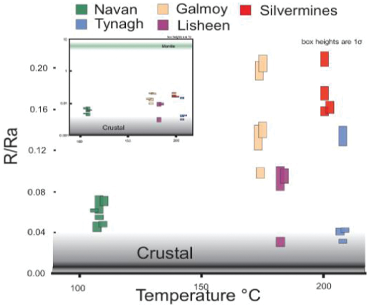
Maximum fluid inclusion temperatures of sphalerite for all ore Irish deposits shown against 3He/4He values of ore fluids. All deposits are dominated 3He/4He ratios that are above 3He crustal radiogenic values, demanding a contribution of mantle-derived volatiles
Mineral deposit research using legacy collections and historic mine sites: A case study of tungsten (-bismuth) mineralisation in south-west England
E. Deady 1, K. R. Moore 2.
1British Geological Survey, Nicker Hill, Keyworth NG12 5GG, UK (eimear@bgs.ac.uk)
2Camborne School of Mines, University of Exeter, Penryn Campus, Cornwall TR10 9EZ, UK
The British Geological Survey (BGS) identifies tungsten and bismuth as being at relatively high risk of supply shortage (BGS Risk List, 2012). Tungsten is dominantly used to produce ‘hard metals’, e.g. tungsten carbide used for cutting and drilling. It is an important steel alloy and has many specialist applications in electronics and as catalysts and pigments. Bismuth is a low toxicity replacement for lead in alloys and is also used in cosmetics and pharmaceuticals. Tungsten has been produced economically in the UK. Production peaked during the Second World War and then declined steadily into the 1950s. The last tungsten mine, Castle-an-Dinas, closed in 1957. The Hemerdon mine in south Devon operated during the world wars and is due to reopen imminently, in response to higher tungsten prices. The demonstrated viability of some tungsten resources and current concerns regarding the security of supply suggest that Cornwall and Devon should be considered a metallogenic province of potential future significance to the UK economy.
We have undertaken a review of tungsten occurrences in south-west England and assessed access to known localities. Access to samples is best achieved through historic research archives. Collaboration between the BGS, Camborne School of Mines, and the National Museum of Scotland (R. Walcott), is underway to compile a record of available material. Up to 2000 samples have been donated to the collections since the late eighteenth century. However, the metadata accompanying the samples is typically limited, such that the context of the samples is frequently unclear. We have assessed the content of the legacy collections, identified significant gaps in the localities represented by tungsten-bearing samples, and collected new samples to augment the BGS collection. We intend to develop a public-access database that describes the availability of lithological and tungsten-bearing specimens.
We will use Castle-an-Dinas, Bray Downs, Vincent and Hemerdon as case studies to demonstrate the current state of access to historic mine sites and availability of research specimens. Initial findings indicate that Castle-an-Dinas and Hemerdon have similar parageneses and are dominated by primary hydrothermal wolframite and arsenopyrite. Hydrothermal veins from Vincent and Bray Downs contain both primary hydrothermal and late stage wolframite and arsenopyrite. All four localities have late stage bismuth mineralisation. Intra-grain bismuthinite±bismutite [Bi2S3±(BiO2)CO3] occurs in primary wolframite and quartz at Hemerdon, Bray Downs, Castle-an-Dinas (Hey and Bannister, 1938)±Vincent. Inter-grain bismuth mineralisation occurs as radiating acicular textured russellite (Bi2WO6) and native bismuth at Hemerdon and as concentric botryoidal infill at Bray Downs, consisting of an assemblage comprising zaïrite [Bi(Fe3+,Al)3(PO4)2(OH)6], phosphoscorodite [Fe(As, P)O4.2H2O], annite [KFe2+3(AlSi3O10)(OH)2] and wolframite. The composition of wolframite (Mn/Mn+Fe) varies between localities, averaging 0·3 at Hemerdon and Castle-an-Dinas, and 0·2 at Bray Downs. Vincent has a consistently higher Mn ratio with average values of 0·49 which is close to the composition of hüberite (ratios >0·5). However, there is little variation between primary and secondary wolframite compositions. We interpret that quartz and wolframite have undergone dissolution and reprecipitation and that the textures of the russellite and zaïrite assemblages represent partial replacement during addition of a bismuth and phosphorous rich fluid, leading to development of secondary bismuthinite±bismutite minerals. South-west England provides an opportunity to investigate the relationship between primary tungsten mineralisation and late bismuth mineralisation. The by-product potential of bismuth may have implications for the economic viability of tungsten deposits globally.
Sr–Nd–Hf–Pb isotope systematics of Tien Shan in Uzbekistan
A. Dolgopolova 1, R. Seltmann 1, R. Armstrong 1, E. Belousova 2, R. Pankhurst 3, D. Konopelko 4, R. Koneev 5.
1NHM, Department of Earth Sciences, CERCAMS, London, UK (allad@nhm.ac.uk)
2GEMOC, Macquarie University, NSW 2109, Australia
3BGS, Keyworth, Nottingham NG12 5GG, UK
4St. Petersburg State University, Geological Faculty, St. Petersburg, Russia
5NUUz, Department of Geology, Tashkent, Uzbekistan
Results of Sr–Nd–Pb–Hf isotope mapping combined with U–Pb zircon SHRIMP ages and Re–Os sulphide geochronology and geochemical study of granitoids from four sampling profiles across terrane boundaries in Uzbekistan reveal distinct reservoir types (cratonic vs turbiditic), corresponding to a diverse nature and origin of granitic magmatism and its hosted ore-forming processes. The study region in Uzbekistan comprises three main tectonic domains (described from E/NE to W/SW) including:
northernmost (as part of Middle Tien Shan), the Beltau-Kurama tectonic zone with recycled crust of continental arc (C1–P2), represented by the giant Kalmakyr Cu–Au porphyry (315 Ma) emplaced within massive Devonian to Carboniferous sediments and volcano-plutonic units. To the W is located the North-Bukantau tectonic zone characterised by D1–C2 oceanic arc tholeiites with slivers of Cambrian oceanic crust and C1–C2 bimodal volcano-plutonic arc with volcanomictic carbonate-terrigenic series
ollowing to the SW are PZ2 turbidites of the Southern Tien Shan accretionary complex, represented by Turkestan-Alai tectonic zone hosting the Zarmitan intrusion-related gold deposit (285 Ma) in Nurata region, and Muruntau giant gold deposit (290 Ma) in Kyzyl-Kum. To the W (SW), it envelopes the Sultanuvais tectonic zone (ensialic arc) that hosts ophiolites
southernmost follow the Zarafshan-Alai and South Gissar tectonic zones, O3–C2 backarc basins stitched by post-collisional granites of C3–P ages developed on pre-Cambrian cratonic crust of the Karakum microcontinent.
Sr–Nd isotopes (whole-rock) of all domains show a wide range of Ndt (−5 to +7) and (87Sr/86Sr)t predominantly between 0·704 and 0·707, indicating involvement of both mantle-derived material (e.g. subduction of oceanic crust) and older crustal sources (Mesoproterozoic model ages).
The large range of Hf-isotope compositions found in zircons of Kurama granites, Middle Tien Shan (Hf mainly −5 to +5) could be due to recycling of older heterogeneous crustal protolith(s). In the Southern Tien Shan some involvement of subducted oceanic crust is examplified by juvenile Hf values of up to +14 and +16 (in Sultan-Uvais and Teksquduk-Kyzylkum, resp.). However, Permo-Carboniferous granitoids occurring across all terrane boundaries exhibit predominantly crustal signatures indicating Neoproterozoic protoliths.
Pb isotopes (whole-rock) exhibit a present day range of 206Pb/204Pb 18·229–20·718, 207Pb/204Pb 15·607–15·823 and 208Pb/204Pb 38·077–39·827. These are in full agreement with Sr–Nd–Hf isotopes indicating the dominance of a crustal component as well as crust-mantle mixing processes.
The samples from three tectonic domains (Middle Tien Shan, Southern Tien Shan and Karakum microcontinent) show a variation of crustal to mixed signatures with a significant contribution of older components. This is a contribution to IGCP-592 sponsored by IUGS-UNESCO.
Barite in the epithermal deposits of western Milos – a link between submarine and subaerial mineralisation?
H. M. Ford 1, D. J. Smith 1, J. Naden 2.
1Department of Geology, University of Leicester, LE1 7RH, UK (hf55@le.ac.uk)
2British Geological Survey, Keyworth, NG12 5GG, UK
The Greek island of Milos in the south Aegean active volcanic arc hosts a range of epithermal and hydrothermal mineralisation styles associated with volcanism in a submarine–subaerial transitional setting (Kilias et al., 2001). In western Milos, three texturally and mineralogically different deposits – Profitis Ilias (low sulphidation epithermal Au), Triades (seafloor-exhalative Pb–Zn– (Ag–Cu) breccia) and Cape Vani (shallow-marine, microbially-mediated Mn-oxide) – have a common feature in the abundance of barite gangue present at each locality.
This ongoing study aims to identify the nature of fluids precipitating barite at each deposit and discuss whether barite can be used to determine a genetic link between the deposits.
Fluid inclusion data from barite and quartz will be used to constrain the fluid types (meteoric, magmatic, seawater or a combination, Kilias et al., 2001) involved in mineralisation at each deposit and determine if a common fluid, or system, was present across the region. Profitis Ilias (5 Mt at 4·4 g t−1 Au and 43 g t−1 Ag) is the highest point on Milos (567 m asl), Cape Vani is situated at sea level 8 km to the north on a coastal peninsula and Triades is approximately equidistant between these deposits (Kilias et al., 2001).
Field data, preliminary SEM and thin section analysis identify late-stage barite mineralisation at Profitis Ilias and syngenetic and late-stage barite at Triades, where fluids evolved by circulation beneath localised silicified lithocaps. At Cape Vani, mineralisation may have been assisted by hydrothermal-seawater mixing on the periphery of this system.
Previous studies in the region have been contradictory in genetic models for Profitis Ilias and Triades and have yet to suggest that a common system may have been responsible for all three deposits (Kilias et al., 2001; Alfieris and Voudouris, 2007; Marschik et al., 2010; Alfieris et al., 2013).
If it is proven that barite±ore mineralisation across the region was deposited from a single system then this may enhance exploration strategies in subduction-related arc settings to include mineralisation styles influenced by shallow marine volcanic and hydrothermal processes.
The rare earth – rare metal deposit Verkhnee Espe, East Kazakhstan
O. Frolova 1, I. Mataibayeva 1, O. Gavrilenko 1, R. Seltmann 2, V. Shatov 3.
1East-Kazakhstan State Technical University, Ust-Kamenogorsk, Kazakhstan, (geolog1984@mail.ru)
2CERCAMS, Department of Earth Sciences, Natural History Museum, London, UK
3A.P. Karpinsky Russian Geological Research Institute (VSEGEI), St. Petersburg, Russia
Rare-metal deposits of East Kazakhstan are characterised by a great diversity. Majority of the explored morphogenetical types of deposits are spatially and genetically linked with late Hercynian granites of average alkalinity and with alkaline to peralkaline granites. Typical for the Verkhnee Espe deposit is a characteristic zone of albitite with rare metal and rare-earth mineralisation (Nb, Ta, Zr) that developed in genetic relation with Permian alkaline granite. The deposit is located in the Delegen-Espinskoy ore zone at the junction of Zharma-Saur and Chingiz-Tarbagatai ore belts (Sherba et al., 1979). The rare metal mineralisation at the Verkhnee Espe deposit is related to altered alkaline granitic rocks of the so-called Greater and Lesser cupolas, exposed in areas of 3·0 and 1·5 km2, respectively, and extending into the near-contact altered host rocks. The granitic cupolas are separated by a screen of host rocks of 0·4 km width; according to the drilling data, both cupolas are merged at a depth of 70–130 m. The host rocks are represented by thin-bedded grey sandstone, siltstone, tuffite, with an admixture of coal and carbonaceous materials; these rocks form an asymmetrical anticline with NW-trending axis. The limbs of the folds dip NE (60–80°) and SW (50–70°). The host rocks are cut by pre-granitic dykes of diabase and diorite porphyry.
The specific feature of the Verkhnee Espe deposit consists in the alkaline metasomatic alteration (fenitisation) that has affected both granitic and host rocks and gave rise to the increased Li2O contents in micas and amphibole and to the enrichment of granite in Li, Rb, REE, Y, Nb, Zr. The ore bodies are represented by the alkaline altered host rocks, forming near-contact ore lodes and vein-shaped bodies composed of albite and alkaline dark-coloured minerals. The alkaline altered rocks are characterised by mostly porphyroblastic microstructures of granitic appearance. Phenocrysts are represented by the prisms of riebeckite and rosettes of aegirine. The microgranoblastic matrix is composed of albite, microcline, quartz, and riebeckite aggregates. The relative amounts of rock-forming minerals in banded altered rocks vary within the following limits (vol.-%): albite (15–70), microcline (10–70), quartz (5–35), riebeckite (5–50), aegirine (3–5), biotite (0–3), astrophyllite (0–10), fluorite (3–4). Gagarinite, zircon, pyrochlore, rutile, titanite, xenotime, fluosilicate, fluocarbonate are the most abundant accessory minerals (Belov and Ermolov, 1996).
Nb, Ta, Zr and REE are of primary economic value. The rare metal contents gradually increase from the inner parts of the pluton to its upper edge especially in the areas of cupola- and ridge-like uplifts. It is noteworthy that vein-shaped bodies, which set off from the near-contact metasomatic lodes, are enriched in rare metals. Considerable amounts of REE are contained in riebeckite and aegirine. These minerals are quite common at the deposit; however, their TR2O3 contents are low (0·18 and 0·14 wt-%, respectively). Accompanying elements in the ore of the Verkhnee Espe deposit are U, Th, Be, Sn, Li, Pb, Zn. Thorium concentrations may reach significant level. Beryllium is represented by phenakite, helvine, ga-dolinite, barylite, which occur as disseminated grains. However, the bulk of Be is concentrated in rock-forming minerals, i.e. microcline, riebeckite, and albite. Tin is disseminated chiefly in riebeckite and aegirine. Accessory cassiterite is present in those ores only where Sn content exceeds 0·014 wt-%. Almost all lead is contained in pyrochlore and only in orebodies no. 1 and 6 is accessory galena reported. Zinc is concentrated in riebeckite, aegirine, astrophyllite, ilmenite. Lithium is incorporated in riebeckite and biotite.
Myanmar (Burma): Tectonics and metallogeny
N. J. Gardiner, L. J. Robb, M. P. Searle.
Department of Earth Sciences, University of Oxford, UK (nickg@earth.ox.ac.uk)
Myanmar (Burma) is one of the largest countries in SE Asia and is known to be rich in tin, tungsten, copper, gold, gemstones, zinc, lead, oil, gas and coal (e.g. Chhibber, 1934). It contains at least three ‘world class’ deposits of differing commodities and genesis: Bawdwin (lead–zinc); Monywa (copper) and Mawchi (tin–tungsten). The country's complex geology reflects a collisional history stretching from the Jurassic–Cretaceous to at least Late Eocene sited at the eastern end of the Indian–Asian suture. It is due to this long and multiple geological and tectonic story that Myanmar has one of the most diverse and richly endowed collections of natural resources in SE Asia: simply, the distribution of ore deposits can be directly related to the tectonic history.
Whereas there is some recent history of exploration and exploitation of mineral deposits within Myanmar (largely in the shape of UN-sponsored programmes in the 1970s and 1980s, and subsequent work by smaller western juniors), as a jurisdiction it remains poorly understood and hugely underdeveloped with regards its natural resources – due in the most part to the prevailing political climate. As the country emerges from several decades of isolation, we believe it is timely to both review and apply more modern techniques to better understand the metallogenesis of this fascinating country.
Broadly, Myanmar can be divided into four principal metallotects: the Magmatic Arc, containing pre-collisional subduction-related granites with associated epithermal Cu–Au mineralisation; the Slate Belt, with multiple post-collisional S-type crustal melt granites that host significant Sn–W mineralisation (part of the SE Asia Tin Granite belts), and also host to a number of mesothermal gold deposits; the Shan Plateau limestones with notable VMS-type lead-zinc deposits; and the Mogok Metamorphic Belt, where (U)HT metamorphism resulted in world-class ruby and corundum-bearing marbles. Additionally, (U)HP metamorphism along the Jade Mines Belt in the North resulted in jadeitic pyroxene and associated serpentinisation of ophiolitic ultramafic rocks within the suture itself.
At Oxford we are taking a multi-disciplined approach to better understand this geological history and relate it to the metallogenic endowment: geochemical, structural, field relations, and metamorphic. We have built a GIS database of known mineral deposits, recorded outcrops and mining activity, and this allows us to directly relate these to the underlying geology. We have, and are continuing to, make a number of key mine visits to observe these deposits on the ground. Finally, by the targetted use of U–Pb dating, metamorphic modelling, and granite geochemistry we hope to better constrain the larger tectonic picture and tie this into the regional geology.
Catchment scale water modelling and its role in identifying potential environmental and socio-economic constraints as part of mining exploration
S. Gibbons 1, J. Shaw 2.
1Environmental Resources Management, Ethos Building, Kings Road, Swansea, SA1 8AS, UK (simon.gibbons@erm.com)
2Environmental Resources Management, Eaton House, Wallbrook Court, North Hinksey Lane, Oxford OX2 0QS, UK
Water evaluation and management during mining exploration and operational activities is crucial to minimise direct and indirect operational costs and also in delivering mining companies the less tangible, but equally critical ‘social license to operate’. Mining is often carried out in remote areas, where the mine will be the most significant and visible user and potential contaminator of water resources. However, wherever it is located, a mine's use of water must be managed in the context of two key aspects: (i) the natural parameters of the resource; its abundance, its temporal variability, and its chemical and physical qualities; and (ii) other users of the resource; other industry, potable water supplies, and ecological requirements of local habitats. It is vital, therefore, that this commodity be assessed to an appropriate degree to help establish the viability and sustainability of the mining project and identify those other stakeholders who may be affected by the mining company's activities.
This presentation will outline the background to catchment scale modelling and presents a cost effective method for establishing a robust water baseline and creating a water management tool to be used throughout the whole mine life cycle. Numerical surface and groundwater modelling has long been established as a tool for reactive management, following collation of years’ worth of data. Now, using freely available remote sensing data and desk study information, analytical modelling techniques can be used cost effectively to provide explorationists a tool for assessing and managing their water consumption requirements at the outset of a new project venture and predicting the impacts this may have on receptors in the entire catchment. Case studies will show how the use of analytical modelling can be used as an evaluation and management tool to help not only assess general watershed parameters and water availability but also how it can be used as a tool to provide decision makers with the information to complete ‘what if?’ scenario assessments. The case studies illustrate how a combined hydrological and hydrogeological model may enable identification of sensitive receptors, water competition issues and contaminant migration pathways to help manage the risks associated with water consumption and its potential contamination from exploration, development and operational activities.
Catchment-scale modelling of water resources, particularly at an early stage of exploration or expansion, allows for greater confidence in understanding the water-related risks associated with the project. This in turn allows for more robust planning at the feasibility stages and consequently, potentially significant cost savings throughout the life of the project. The visual nature of the model is useful in stakeholder engagement to demonstrate a mine's potential impacts and benefits as part of a larger, regional player within the greater catchment area.
Water management plays an increasingly critical role in the viability of mining projects and, just as with the mineral resource itself, water should be understood as well as possible as early as possible. As the project proceeds and more data become available, this understanding should build on previous models to manage project-specific risks and make the most of project-specific opportunities.
Pt contained within secondary pyrite – an example from Sron Garbh, an unconventional magmatic Cu–Ni–platinum group element prospect, Stirlingshire, Scotland
S. D. Graham 1, 2, D. A. Holwell 1, I. McDonald 3, C. Sangster 4.
1Department of Geology, University of Leicester, University Road, Leicester LE1 7RH, UK (shaun.graham@zeiss.com)
2Carl Zeiss Microscopy, 509 Coldhams Lane, Cambridge CB1 3JS, UK
3School of Earth and Ocean Science, Cardiff University, Park Place, Cardiff CF10 3AT, UK
4Scotgold Resources Limited, Tyndrum, Stirlingshire, Scotland FK20 8RY, UK
The Sron Garbh (SG) intrusion located 2·5 km north of Tyndrum, represents an unconventional lamprophyric Cu–Ni–platinum group element (PGE) sulphide prospect. The PGE-bearing sulphides are hosted within a hornblende-rich basal appinite cumulate with a PGE poor monzodiorite located above. These suites are related to the post-tectonic slab detachment event ca 430 Ma that produced voluminous post-Caledonian granites which were intruded throughout the Scottish Caledonides (Neilson et al., 2009). Assay data from rock chip sampling provided grades of up to 1·14 g t−1 Pt, 0·79 g t−1 Pd, 0·18 g t−1 Au, 0·21%Ni and 0·82%Cu.
The sulphide mineralisation can be split into two styles: (i) a blebby pyrite (Py)-chalcopyrite (Cpy)±bravoite±hengleinite±gersdorffite±Co–Ni–pyrite; and (ii) a disseminated Py-Cpy dominated assemblage±hengleinite±bravoite±vaesite±cobalite±gersdorffite±Co–Ni–pyrite. Geochemical data outlines a consistent Pt/Pd ratio of ∼0·83 indicating a well homogenised sulphide liquid.
Sixty-nine platinum group minerals (PGM) were identified within the appinite portion of the intrusion and are only associated with the disseminated style of mineralisation. Pd bearing-PGM represents 90% of the PGM by area. Therefore, when compared with the Pt/Pd ratio there is a vast visible underrepresentation of Pt bearing PGM.
The Py-Cpy ± Ni sulphide assemblage with associated Sb-bearing PGM and silicate alteration has recently been recognised as a late stage low temperature hydrothermal replacement assemblage (Smith et al., 2012). The presence of Pt contained in pyrite has been recognised in various deposits (Piña et al., 2012; Djon et al., 2012; Piña et al., 2012; Djon and Barnes, 2012) suggest hydrothermal fluids may dissolve and redistribute Pt and As into secondary pyrite and that the Pt concentrations are a result of the presence of Co and As distorting the crystal lattice allowing Pt2+ to substitute for Fe2+.
LA-ICP-MS analyses of the sulphides were undertaken and Pt was found within pyrite in concentrations up to 22 ppm along with 10 840 ppm Co and 71 ppm As. Other analyses show Ni-sulphides (e.g. millerite) may also be an important repository of Pt with up to 5·2 ppm.
The identification of PGEs within the appinites suggests the voluminous post-Caledonian intrusives have the potential to host unusual but economic grades of PGEs. Furthermore, SronG adds to the growing number of deposits where Pt is known to be contained within secondary pyrite. This and similar studies thus outline how pyrite may be an important PGE repository.
New investigations into the Klondikearbh Gold District, Yukon, Canada
M. Grimshaw, R. J. Chapman, G. W. McLeod.
School of Earth and Environment, University of Leeds, Leeds LS2 9JT, UK (ee09mrg@leeds.ac.uk)
The Klondike goldfields of the Yukon, NW Canada, were discovered in 1896 and continue to be exploited. Estimates of total production vary between 13–20(+) Moz of gold (Chapman et al., 2010). At least 7 Moz of gold has come from the small (20 km2) drainages of Eldorado and Bonanza Creeks where gold compositions have been used to establish clear placer-lode relationships (Chapman et al., 2010). The Lone Star ridge separates the creeks and comprises of orogenic veins within highly deformed metasediments, but there is a distinct lack of large regional fault systems such as those associated with other rich orogenic gold systems worldwide. The research aims to develop a depositional model for this very small, spectacularly rich mineralising system.
The evolution of the gold placers may be studied in detail only after the formation of palaeoplacers at 6 Ma (Lowey et al., 2006). Constraining the volumes of material eroded has implications for our understanding of the original orebody, and hence it is important to establish the degree of uplift post mineralisation at 160 Ma (Mortensen, 2013). This subject will be investigated using apatite fission track, Ar–Ar, and (U, Th/He) thermochronology in conjunction with the known geological evolution of the western Yukon.
This project aims to integrate information gained from studying lode and placer mineralisation with regional tectonic studies to develop a deposit model for this economically important and unusual mineral occurrence.
Development of a handheld XRD mineral analyser
G. M. Hansford.
University of Leicester, Space Research Centre, Department of Physics and Astronomy, University Road, Leicester LE1 7RH, UK (gmh14@leicester.ac.uk)
In collaboration with Bruker Elemental, the author is developing a handheld mineral analyser allowing rapid mineral identification and quantification in the field. Handheld X-ray fluorescence (XRF) instruments are widely used in the mining industry, and are capable of quantifying elements down to trace levels, generally in the low parts-per-million range. However, elemental quantification does not permit the identification of the mineral species present for which the method of choice is X-ray diffraction (XRD). The aim of this collaboration is to add an XRD capability to handheld XRF instrumentation as an evolution of the existing technology, facilitating both rapid development and customer acceptance.
The critical enabling development is the invention of a novel XRD technique at the University of Leicester which exhibits almost complete insensitivity to the sample morphology (Hansford, 2011; Hansford, 2013). A consequence of this unique property is that whole rock specimens become amenable to XRD analysis without sample preparation, inconceivable in conventional methods. The new technique is also fast, involves no moving parts, and requires a back-reflection geometry which favours a compact and lightweight instrument design, compatible with XRF measurements.
The main limitation of the handheld mineral analyser will be low XRD resolution. In situations where the mineralogy is relatively simple and already reasonably well-defined, such as in mining of iron ores and limestone quarrying, it is expected that the performance will be sufficient to provide useful mineral quantification. The new instrumentation will enable rapid delineation of ore boundaries and real-time assays at the mine face. The assessment of ore grades will allow efficient management of blasting, excavation and haulage operations while the analysis of feedstocks, concentrates and tailings will permit the mine operator to gauge on-site enrichment efficiencies. These advantages all serve to improve the overall mine productivity. The handheld mineral analyser may also play a role in exploration activities.
Recent trends in the global mining industry – trying to make sense of what is going on
M. Harris 1, 2.
1Business Development, Rio Tinto plc, 2 Eastbourne Terrace, London W2 6LG, UK
2Department of Earth Science & Engineering, Royal School of Mines, Imperial College, London, UK (mike.harris@riotinto.com)
Headlines in the international press over the last 18 months have painted a picture of the mining industry as being in retreat – an industry forgoing any thoughts of growth through mergers and acquisitions (M&A), cutting exploration budgets to the bone and selling assets to bring down the debt mountains accumulated in the run-up to the Global Financial Crisis (GFC) and/or during the euphoria of the post-GFC commodity price revival. Headlines focused on an industry concentrating on cutting costs including wide scale redundancies and cleansing its executive ranks of the CEOs that oversaw their slide into levels of write-offs unimaginable from the likes of the senior-most miners.
The mining industry went through a period of almost unprecedented growth with mining-related investment in Australia alone going from under A$10 billion in 2004 to almost A$100 billion in 2012 (Sydney Morning Herald, 2013). These dizzying rates of growth were built on a view of a ‘stronger for longer’ super cycle of demand on the back of the emerging economies, particularly China.
Many companies entered into commitments beyond their abilities to fund them once sentiment turned with the inevitable fall out. As an example, total exploration spending in Canada in 2013 was down 41% over 2012 mainly due to weakness among the juniors (MineNewsPremium.net) with the market capitalisations of junior companies on the two Canadian exchanges dropping 25% from August 2011 to August 2012 and a further 29% from then to August 2013 (BNAmericas, 2013). The majors were no exception with Rio Tinto declaring the first yearly loss in its history ($2·99bn), Anglo American the first in a decade ($1·5bn) and Vale the first quarterly loss in a decade ($2·6bn for Q4 2012).
Apart from this are the inescapable facts of a growing world population and a rapidly escalating trend from rural-based existences to urbanisation in China, India, Africa and elsewhere in the developing world. In addition, prices for most commodities are at levels far in excess of average production costs.
How do we as employees, prospective employees or those dependent on the mining industry for research support and/or consultancy fees square this conundrum of increasing demand and healthy prices with an industry seemingly in retreat?
The presentation will look at what is being reported in the press and try to place it in a supply/demand context from the perspective of the MDSG audience using Rio Tinto as the primary example to explain the trends.
PERC minerals reporting for Europe: More than just a classification
S. Henley.
Resources Computing International Ltd, Matlock, Derbyshire, UK (steve@vmine.net)
The Pan-European Reserves & Resources Reporting Committee (PERC) has its origins in the Institution of Mining and Metallurgy (IMM) Reserves Committee which published the IMM Reporting Code in 1991. This code evolved in parallel with counterparts in Australia, South Africa, Canada, and the USA, and with the formation of CRIRSCO (Committee for Mineral Reserves International Reporting Standards) a common classification and similar reporting principles – competence, materiality, and transparency – with emphasis on self-certification and peer review, were adopted by all of these, and subsequently also by Chile and Russia. PERC itself was set up in 2006 by four parent organisations: the Institute of Materials, Minerals and Mining (IOM3), the European Federation of Geologists (EFG), the Geological Society (GSL), and the Institute of Geologists of Ireland (IGI). PERC was given a formal identity in 2013 as a ‘not-for-profit’ association based in Brussels.
The PERC Reporting Standard (latest revision published in 2013) is recognised by the European Securities and Markets Authority (ESMA) alongside the six other CRIRSCO-aligned standards for reporting of exploration results, mineral resources, and mineral reserves by companies listed on stock exchanges within the European Union.
In its new and more formal role, PERC has also made training its top priority. The workshop at this conference is the second such workshop that PERC has organised, and together with EFG it will be organising a conference on minerals standards in Brussels on 21–22 November 2014.
PERC members (who all provide their time and services voluntarily) also participate actively in European Union and global projects which are related to its standards-setting role. These include the European Innovation Partnership on Raw Materials, which promises to be an umbrella project for a number of separate initiatives; the Minventory project, led by the British Geological Survey (BGS) and the Bureau des Recherches Geologiques et Minieres (BRGM) to set up an open online metadata portal for access to mineral resources information in EU member states as well as several other European countries; and the Extract-IT project, a small EU Framework 7 foresight project to identify mining technology priorities of the next four decades. PERC has also assisted the Russian professional geological community in developing their own reporting standard, which is likely to supersede the existing Soviet-era reporting system. PERC has also been involved, together with the CRIRSCO members, in development of the United Nations Framework Classification (UNFC-2009) which provides a mechanism for recording of detailed information for mining companies’ planning purposes as well as for governmental mineral inventories.
Central to the PERC Reporting Standard is the concept of the Competent Person: a professional (usually a geoscientist) who has appropriate qualifications and substantial relevant experience and who takes personal responsibility for the content of public statements of exploration results, mineral resources, and mineral reserves. Of course, the Competent Person must also be familiar with the requirements of the Reporting Standard, hence PERC's emphasis on the training requirements.
Geochronology of the River Vein prospect: Constraints on the genesis of vein-hosted gold mineralisation in the Dalradian Supergroup
N. J. Hill 1, G. R. T. Jenkin 1, D. F. Mark 2, D. Selby 3, N. Roberts 4, C. J. S. Sangster 5.
1Department of Geology, University of Leicester, University Road, Leicester LE1 7RH, UK (njh35@le.ac.uk)
2Scottish Universities Environmental Research Centre, Scottish Enterprise Technology Park, Glasgow G75 0QF, UK
3Department of Earth Sciences, Durham University, Science Labs, Durham DH1 3LE, UK
4NIGL, British Geological Survey, Keyworth, Nottingham NG12 5GG, UK
5Scotgold Resources Limited, Upper Station, Tyndrum, Stirlingshire FK20 8RY, UK
Regional mapping in conjunction with Scotgold Resources exploration program provides a unique opportunity to constrain the age of gold mineralisation in the Tyndrum area, Scotland. The Cononish deposit, Tyndrum, is the largest gold resource in Scotland and while recent work to improve existing geochronology suggests the age of mineralisation at Cononish is close to 410 Ma (Treagus et al., 1999; Rice et al., 2012), the age of other mineralised occurrences in the Tyndrum area is unknown. New high-precision 40Ar/39Ar, U–Pb and Re–Os ages for the recently identified River Vein prospect will be presented in order to place constraints on the nature of mineralisation and to constrain the geometry of the hydrothermal system in the Tyndrum area. The River Vein prospect exhibits both gold and molybdenite mineralisation, unique to the area at current understanding. Cross-cutting relationships constrain molybdenite mineralisation to be older than gold mineralisation with all mineralisation observed to cross cut the metamorphic foliation and therefore post-date peak metamorphism [between 473 and 465 Ma (Baxter et al., 2002; Bird et al., 2013).
Sericite from the main River Vein gold-bearing quartz vein was dated using 40Ar/39Ar analysis by UV laser ablation and step-heating. The sericite yields ages close to 410 Ma giving a minimum age for gold mineralisation comparable with existing ages for the Cononish deposit (Treagus et al., 1999; Rice et al., 2012). Gold mineralisation is interpreted to have occurred close to 410 Ma due to the presence of electrum in fractures that also host sericite. Re–Os and U–Pb ages for molybdenite and rutile respectively will provide a maximum age constraint for mineralisation in the Tyndrum area.
This study concludes that all gold mineralisation in the Tyndrum area is coeval and part of a single hydrothermal system. This study also concludes that two distinct gold mineralising events can be observed in the Dalradian Supergroup; gold deposits at Curraghinalt and Cavanacaw are interpreted to be orogenic in origin and recent dating supports this (Rice et al., 2012). Mineralisation at Cononish, the River Vein prospect and the Rhynie chert, Aberdeenshire, are all dated close to 410 Ma and overlap with the emplacement of the Caledonian granite suite suggesting an intrusion-related origin. This places constraints on the development of exploration models and the understanding of the evolution of the Dalradian Supergroup, and its potential correlatives, as a metallogenic province.
Using the Neoproterozoic S-isotope record to illuminate the genesis of the Cononish deposit, Scotland
N. J. Hill 1, G. R. T. Jenkin 1, A. J. Boyce 2, C. J. S. Sangster 3, D. J. Catterall 4, D. A. Holwell 1, J. Naden 5, C. M. Rice 6.
1Department of Geology, University of Leicester, University Road, Leicester LE1 7RH, UK (njh35@le.ac.uk)
2Scottish Universities Environmental Research Centre, Scottish Enterprise Technology Park, Glasgow G75 0QF, UK
3Scotgold Resources Limited, Upper Station, Tyndrum, Stirlingshire FK20 8RY, UK
4Farscape Exploration (FarEx) Botswana, Plot 431, Disaneng, Maun, PO Box 777, Botswana
5British Geological Survey, Keyworth, Nottingham NG12 5GG, UK
6Geology and Petroleum Geology, Meston Building, Kings College, University of Aberdeen AB24 3UE, UK
In recent years increasing gold prices have rejuvenated interest in vein-hosted gold mineralisation in the Dalradian Supergroup of Scotland and Northern Ireland. The Cononish deposit, Tyndrum, hosts the largest gold resource in Scotland at 169 000 oz Au and 631 000 oz Ag (Scotgold Resources Ltd, 2012). The genesis of this and other gold-bearing vein deposits in the Dalradian Supergroup is unclear, with both orogenic and intrusion-related origins advocated by previous workers (Curtis et al., 1993; Hall et al., 1994).
This work presents an extensive new dataset of S-isotope analyses from mineralised occurrences, igneous intrusions and the host metasedimentary sequence in the Tyndrum area. 34S values for gold-bearing mineralisation ranges from −2 to +12‰, but show distinct populations related to the nature of the mineralisation and the location. This range in 34S can be accounted for by sedimentary sulphur from the Dalradian Supergroup [values between −15 and +42‰ (Hall et al., 1994; Hall et al., 1994)].
Correlation of the global Neoproterozoic S-isotope record to data available for the Dalradian Supergroup in Scotland indicates the immediate host rocks (lower-Dalradian) are not the major source of sulphur in the mineralisation; this is consistent with the low bulk sulphur and lack of metal enrichment in these sediments. Modelling of the input sedimentary sulphur into gold-bearing quartz veins with 34S values of +12‰, indicates that between 32 and 66% of the sulphur was sourced from units similar to the Ben Eagach SEDEX horizon, 62 to 100% from diagenetic sulphides in the Ben Eagach Schists or 71 to 100% from lithologies similar to the Ben Challum Quartzite mineralised horizon.
Our assessment concludes that S-rich, SEDEX-bearing, Easdale Subgroup (middle-Dalradian) metasedimentary rocks lying stratigraphically above the host rocks represent the most realistic source of sedimentary sulphur in the Dalradian Supergroup. Recent re-interpretation of the structural evolution of the Tyndrum area suggests Easdale Subgroup metasedimentary rocks, enriched in 34S, sulphur, and possibly metals, are repeated at depth due to folding (Tanner, 2012), which lends credence to these rocks being the source of sedimentary sulphur in the gold mineralising system.
Geochemistry of hydrothermal fluids and ore components from the Coranda-Hondol Deposit, western Romania
D. Holder 1, P. Treloar 1, A. Boyce 2, S. Chryssoulis 3, A. Hastie 1, A. Rankin 1.
1Centre for Earth & Environmental Science Research, Kingston University, Surrey, KT1 2EE, UK (david.holder@kingston.ac.uk)
2SUERC, Rankin Avenue, Scottish Enterprise Technology Park, East Kilbride, G75 0QF, UK
3Amtel, 100 Collip Circle, Suite 205, London, ON N6G 4X8, Canada
The ‘Golden Quadrilateral’ of Romania is a rich mineralised magmatic province hosting major porphyry and epithermal base and precious metal deposits. Magmatism and associated mineralisation is controlled by a series of NW–SE trending transtensional pull-part basins (e.g. Brad-Sacaramb and Zlatna-Stanija). These basins were developed as a result of the opposite sense rotation of the Alcapa and Tisza microcontinents during the late Miocene that facilitated extension-related calc-alkaline magmatism (Udubasa et al., 1992). The 900 km2 quadrilateral hosts over 64 Cu–Au porphyry and epithermal Au deposits (Ciobanu et al., 2004). This includes the world-class Rosia Poieni porphyry [350 Mt Cu (Ciobanu et al., 2004)] and the epithermal vein-breccia deposit of Rosia Montana [14·6 Moz Au (Gossage et al., 2009)].
The focus of this study is the Coranda-Hondol deposit (∼2·4 Moz at 1·6 g t−1 Au) located in the Brad-Sacaramb basin, which is one of numerous Au (Te-rich) epithermal deposits in the Brad-Sacaramb basin (e.g. Sacaramb, Barza, Magura). The deposit displays a wide range of ore styles, not observed elsewhere i.e. pyrite disseminations and telluride-rich polymetallic veins (Au–Pb–Zn). KMnO4 staining coupled with trace element characterisation using secondary ion mass spectrometry has distinguished different pyrite generations and morphologies. Trace element analyses and gold deportment studies show that the majority of Au is found as solid solution in pyrite, typically associated with arsenian zones. Botryoidal pyrites found in quartz-pyrite veins have been found to contain >200 ppm Au in solid solution. In contrast, Au in porous pyrite is typically associated with colloidal Au and Au–Ag tellurides (e.g. nagyagite, calaverite and sylvanite). Massive arsenic-poor pyrites tend to be depleted in Au and other trace elements (e.g. Ag, Cu, Te).
S isotope analyses of the various sulphide morphologies reveal little variation in 34S data from the deposit (−2 to +2‰) indicating a dominant magmatic source of sulphur. Similarly ∼200–300°C, low salinity (<10 wt-% NaCl equiv.) fluid inclusions, coupled with 618Ofluid (+6 to +11‰) and preliminary D data again support a dominance of magmatic hydrothermal fluids, with only limited evidence of meteoric water input. These stable isotope data are consistent with other deposits in the Brad-Sacaramb basin (Alderton and Fallick, 2000).
Superconcentration of PGE, Au and semi metals by multi-stage enrichment and dissolution of sulphide liquids: Evidence for the Skaergaard intrusion
D. A. Holwell 1, R. R. Keays 2, M. R. Williams 1, I. McDonald 3.
1Department of Geology, University of Leicester, University Road, Leicester LE1 7RH, UK (dah29@le.ac.uk)
2School of Geosciences, Monash University, Victoria 3800, Australia
3School of Earth and Ocean Sciences, Cardiff University, Park Place, Cardiff CF10 3YE, UK
Deposits of magmatic Ni–Cu–PGE–Au sulphides form when an immiscible sulphide liquid separates from a mafic or ultramafic silicate magma. How well the sulphide liquid becomes enriched in metals is determined by how much silicate magma it can interact with: often referred to as the R-factor (the ratio of silicate magma to sulphide liquid). To attain the high metal tenors seen in economic deposits, a sulphide liquid generally needs to have formed under conditions of high R factors. However, one process that can enrich a sulphide liquid to very high tenors, is by partial resorption of the sulphide liquid by the magma (Kerr and Leitch, 2005). This is where the interaction of a sulphide liquid with multiple packages of S-undersaturated magma, for example in a conduit system, results in the sulphide being redissolved back in to the magma, but the metals, with high distribution coefficients between sulphide liquid and silicate magma, remain in the reduced-volume sulphide, increasing the tenor, and ‘apparent’ R-factor.
Whilst this process may be common in open systems, it is considered to be much less effective in closed systems (Kerr and Leitch, 2005). However, we show that the Platinova Reef, a magmatic PGE-Au deposit hosted by the closed-system Skaergaard intrusion, east Greenland, is most likely to have attained its high metal tenors by an analogous process (Holwell and Keays, 2014).
The Platinova Reef contains tiny Cu sulphides that make up ∼0·0005 vol.-% of the host gabbros, with the sulphides also containing Pd- and Au-bearing minerals. The sulphides show no evidence of major S loss, nor do they have the size to have effectively settled through, and homogenised with, the entire magma column. We interpret them to have formed in situ, and attained their high tenors (around 3000 ppm Pd) by separation into a highly enriched magma package. This was the result of an initial sulphide liquid settling through the magma, sequestering all the PGE, Au and semi-metals, but then being completely redissolved at the hot, Fe-rich crystal-magma interface, to produce a highly metal enriched magma. When this package later became S saturated, small droplets were able to attain extremely high tenors without the need to homogenise with a large volume of magma. The volume of sulphide was so small that the effects of the relative distribution coefficients between the metals can be seen, producing an orebody with offsets in peak metals in the order Pt = Pd>Au>Cu. When sulphide volumes increased, low tenor sulphides started to rain down, and sequestered all of the remaining Au in a single, Au-rich layer, and Se was enriched in a thicker package above this, producing sulphides with the lowest S/Se ratios (190) ever recorded in magmatic sulphide ores.
The Platinova Reef illustrates that in order for sulphides in closed systems, which form in the upper parts of magma chambers, to become enriched enough to economic levels, the process of sulphide dissolution, and in this case, two-stage concentration, is essential.
Possible controls on Fe–Ti–P mineralisation in the Upper Zone of the Bushveld Complex
V. C. Honour 1, M. C. S. Humphreys 2, L. J. Robb 1, M. J. Stock 1, L. Longridge 3.
1Department of Earth Sciences, University of Oxford, OX1 3AN, UK
2Department of Earth Sciences, Durham University, Science Labs, Durham, DH1 3LE, UK
3Bushveld Minerals Ltd, 24 Fricker Road, Illovo, 2116, Johannesburg, South Africa
The Bushveld Complex, dated at 2·06 Ga, is a 65 000 km2 layered intrusion, in northern South Africa. It contains the world's largest platinum, palladium, vanadium and chromium resources, and represents an unusually well-preserved example of a Large Igneous Province. The Rustenburg Layered Suite, which comprises the lower mafic portion of the Bushveld Complex, was emplaced at shallow crustal levels and is divided into five zones on the basis of variations in mineralogy and geochemistry. Three of these zones currently have economic ore potential: the Critical Zone, which hosts world-class deposits of chromium and platinum; the Main Zone, which contains the platinum-producing Merensky Reef and Pyramid Gabbronorite, which is quarried for dimension stone; and the Upper Zone, which contains significant Fe–V–Ti resources. The present study focuses on the nature of Fe–Ti and apatite mineralisation within the Upper Zone.
During a recent exploration campaign, Bushveld Minerals Ltd drilled a number of holes through the Upper Zone, targeting regions believed to contain economic quantities of magnetite. Assay results reveal geochemical heterogeneity and fluctuations in Fe, V, Ti and P reflecting variations in the concentrations of magnetite, ilmenite and apatite through the core. Fe2O3 contents range from 10 to 70%, related to variations in the magnetite content. Fe2O3 correlates positively with TiO2, a shallower trend below ∼40 wt-% Fe2O3 indicating increased proportions of ilmenite in the most magnetite-rich layers. Magnetite layers within the cored samples can appear without phosphate, but phosphate is always associated with magnetite. Two major spikes in P2O5 are observed within the core samples. The first phosphate kick starts abruptly over 10 m; accompanied by a significant decrease in Fe and Ti, and preceded by a drop to low V, Cu and Ni contents (Fig. 1). The second phosphate kick is of a similar magnitude but is not accompanied by a decrease in transition metal contents.
Assay results over the first phosphate kick in core VK18
Preliminary petrologic observations suggest that apatite grain size distribution varies with higher bulk rock P2O5 concentrations: P-rich layers host the largest range in apatite sizes. Sulphides and oxides are anhedral, with sulphides forming irregular or rounded globules sitting between cumulus minerals and tending to be associated with apatite and oxides.
Initial observations suggest that the two phosphate-rich horizons may have formed through different magmatic processes. Recent work at the Sept Iles layered intrusion in Canada suggests that silicate liquid immiscibility may have been responsible for the accumulation of Fe–Ti–P deposits (Namur et al., 2012; Cawthorn, 2013). It is possible that a similar process occurred in the Upper Zone of the Bushveld Complex. We are evaluating the possible roles that continuous fractional crystallisation and/or silicate liquid immiscibility may have played in the origin and development of these deposits.
Portable X-ray fluorescence (XRF) analysers – The good, the bad and the ugly
T. M. Houlahan.
Olympus NDT, c/o 48 Woerd Avenue, Waltham, MA 02453, USA
Portable X-ray fluorescence (XRF) instruments have become an increasingly important capital expenditure item for mineral exploration companies over the last 10 years. Instruction on reporting of handheld XRF data is now included in Section 1 Sampling Techniques and Data of the JORC Code, 2012 Edition – Table 1 Report Template. It is well documented that ‘fit for purpose’ application of this technology can genuinely provide exploration companies massive benefits in time as well as savings of hundreds of thousands and even millions of dollars per project. Case studies from several exploration companies will be presented that provide real world examples of the ‘good’ that can be delivered by portable XRF in the context of the challenging market conditions that exist at present.
However, the benefits that portable XRF deliver can be compromised (the ‘bad’) when in the hands of inadequately trained users. The establishment of a successful portable XRF program depends on many aspects which can include (but is not limited to): designing an XRF testing program with a view to achieving specified objectives; establishing a testing methodology appropriate to the type of samples being tested (soils, rock outcrop, drill cuttings, drill core); undertaking orientation test work on samples upon initial acquisition of an XRF; implementation of best practice data management and QA/QC protocols as part of the testing program; understanding the limitations of portable XRF technology (lower limits of detection, spectral overlaps, calibration factors, dealing with sample heterogeneity).
The vitally important aspects listed above will also be discussed.
Examples will also be provided that illustrate the ‘ugly’, where XRF results have produced misleading data and results inappropriately reported in public announcements.
This will be a presentation to promote interactive and ongoing discussion of best practice portable XRF methodologies. Adoption of cost effective exploration techniques is particularly important in the current market climate. This presentation will demonstrate how this is possible with XRF provided robust procedures and protocols are implemented.
Controls on orthomagmatic Ni–Cu–PGE mineralisation in western Scotland
H. S. R. Hughes 1, I. McDonald 1, A. J. Boyce 2, A. C. K. Kerr 1.
1School of Earth and Ocean Sciences, Cardiff University, Main Building, Park Place, Cardiff CF10 3AT, UK (HughesH6@cf.ac.uk)
2Scottish Universities Environment Research Centre, Rankine Avenue, East Kilbride, Glasgow G75 0QF, UK
In recent literature, the apparent strong correlation between plume magmatism, Archaean cratonic lithosphere (particularly at the margins) and orthomagmatic Ni–Cu–PGE sulphide deposits has been highlighted (e.g. Begg, 2010; Maier and Groves, 2011). Although the reasons for this correlation remain contentious (Arndt, 2013), this may be a reflection of some physical or chemical interaction between ascending asthenospheric plume magmas, and partial melts derived from a region of the subcontinental lithospheric mantle (SCLM). This desirable combination of plume magmatism intruding through an Archaean cratonic region exists in Western Scotland, where the British Palaeogene Igneous Province (BPIP; part of the North Atlantic Igneous Province) has intruded into a segment of the North Atlantic Craton (NAC; Lewisian in Scotland). Evidence of an enriched lithospheric keel below Western Scotland at the margin of the NAC, has been found in the form of Cu–Au–PGE enriched spinel lherzolite mantle xenoliths, which highlight a considerable elevation in the concentration of these elements in comparison to ‘Primitive Mantle’ at similar MgO contents. Additionally the Palaeoproterozoic Scourie Dyke Swarm highlights the magmatic contributions of the metasomatised SCLM keel to widespread melting events (Hughes et al., 2013). Due to the similarities in geological history between the NAC-portion of Greenland and Western Scotland, and considering the known Greenlandic Ni–Cu–PGE mineralisation, the BPIP is potentially the most prospective PGE province in Western Europe. This research focuses on the Scottish sector of the BPIP and also includes Caledonian (subduction-related) magmatics of this region. Thus the temporal and spatial abundances of PGE can be used to understand the mineralisation controls for orthomagmatic deposits here.
Powdered whole-rock grab samples were subjected to ICP-OES and ICP-MS analysis for major and trace elements, and NiS fire assay with ICP-MS finish to determine PGE and Au abundances. A selection of samples underwent S-isotope analysis via conventional (following whole-rock S extraction) and laser combustion (for larger sulphide minerals) methodologies.
The overall ‘prospectivity’ of the BPIP can be established by bulk geochemical analysis of volcanics from this area, particularly using the abundance of chalcophile elements in silicate lavas (e.g. Cu). By comparison to similar volcanics in Greenland, we find that both S-saturated and -undersaturated volcanics are found in the BPIP. This suggests that variably, S-saturation has been achieved prior to the eruption of these lavas, and may hint at the possibility of mineralisation lower down in the magmatic plumbing system. Whole-rock S-isotope analyses of minor and shallow-level intrusives indicates that S-saturation has been achieved following substantial contamination of magmas by crustally derived S, with a characteristically light isotopic signature (e.g. basaltic dykes recorded on the Isle of Skye with S compositions as light as δ34S = −30·7‰). Elsewhere on the Isle of Rum, ultramafic volcanic plugs can be found to contain abundant late-magmatic sulphides (pentlandite, chalcopyrite, pyrrhotite) with δ34S = −14·8‰, and for which the S-isotopic signature and abundance of sulphides are directly correlated to the abundance of platinum group minerals (various Pt–Pd–Ir–As–Sb–Te–Bi minerals) and therefore PGE grade. By correlating the likely S-rich crustal contaminants (Jurassic mudrocks) across the Hebridean Basin, a mechanism by which late-magmatic PGM-bearing sulphides accumulated and ‘slumped’ during volcanic plug cessation can be envisaged.
Overall, despite the close geologic history of western Scotland to Greenland (within the North Atlantic Craton) little or no Ni–Cu–PGE exploration has taken place here to date. Our reconnaissance data indicate that the BPIP is prospective for orthomagmatic mineralisation in a magma conduit.
The final Gardar frontier: Critical metal exploration at the Paatusoq Syenite Complex, South East Greenland
J. W. Hughes 1, 2, A. A. Finch 2, M. Stacey 2, O. Christiansen 1.
1NunaMinerals A/S, Issortarfimmut 1, Postbox-790, DK-3900, Nuuk, Greenland (jh@nunaminerals.com)
2Dept. Earth and Env. Sciences, University of St Andrews, North Street, St Andrews, Fife KY16 9AL, UK
One of the most studied alkaline provinces in the world is the mid-Proterozoic (1350–1140 Ma) Gardar Alkaline Igneous Province of South Greenland, which is situated in the zone encompassing the southern margin of the North Atlantic Craton (NAC) and Ketilidian Julianehåb Batholith. This lithospherically weak zone was subject to repeated rifting in response to the breakup of Palaeopangea, resulting in the emplacement of the Gardar (Upton et al., 2003). The alkaline magmas were sourced from SCLM, which had been enriched during earlier northwards subduction beneath the NAC (Goodenough et al., 2002). The province is widely recognised as a major critical metals depository, including the agpaitic Ilimaussaq Intrusion that contains the two largest rare earth element (REE) deposits outside of China, and the miaskitic Motzfeldt Intrusion, which is acknowledged as one of the largest tantalum deposits on Earth (McCreath et al., 2013). Despite intensive commercial interest in the province, the Gardar complex at Paatusoq has not been subject to exploration or academic investigation. However Paatusoq is associated with REE and niobium anomalies in regional stream sediment sampling by the Geological Survey of Denmark and Greenland, GEUS (Steenfelt, 2012). Paatusoq comprises of two intrusive centres: The Paatusoq Syenite Centre (PSC) which is approximately 20 km in diameter and covers an area of ∼ 240 km2, next to the smaller potentially consanguineous ∼ 23 km2 Paatusoq Gabbro Centre. They intrude Ketilidian age granulite-facies meta-sediments to the East, and the Psammite–Pelite Zone unconformably overlying granitoids of the Julianehåb Batholith to the West (Garde et al., 2002). We infer that the structurally weak boundary had a role in the sitting of the two centres. The PSC was interpreted as part of the Ketilidian Rapakivi Granite Suite during regional mapping by GEUS (Grocott et al., 1999). However a U–Pb zircon date of 1144±1 Ma (Hamilton, unpublished data) revealed Gardar origins. Helicopter-supported reconnaissance of the Paatusoq region during July 2013 established that the PSC is made up of nested syenite bodies comprising of augite syenite and quartz syenite units, exposed from sea level up to 2519 m elevation. Internal contacts are subvertical. In some localities, metre-scale igneous layering is observed. The eastern margin of the PSC forms a xenolith-rich zone, consistent with magmatic stoping as the primary mechanism for emplacement. The majority of the complex is syenite with blue schiller in hand specimen, in which felsics are euhedral pristine cryptoperthitic feldspar, with interstitial mafics dominated by aegirine-augite, often containing oriented lamellae of Fe oxides. The syenite resembles the SI4 nepheline syenite in the Illerfissalik Centre (Emeleus and Harry, 1970). The syenite is cut by few dykes consistent with a Late-Gardar age. The complex is also cut by 1–2 m thick inclined sheets of alkali granite, often themselves bisected by dolerite yielding spectacular liquid/liquid interface textures. Ongoing studies include thin section petrography, electron probe microanalysis; cathodoluminescence of alkali feldspars is being used to determine the extent of late-stage juvenile hydrothermal alteration (Finch and Klein, 1999) and the halogen content of biotite to assess the fluorine-content of late stage fluids (Finch et al., 1995). The most intensively mineralised complexes in the Gardar are associated with highly fluorine-rich fluids (Finch et al., 1995) and red-luminescent alkali feldspars (Finch and Klein, 1999). Along with whole rock geochemistry these indicators will provide a robust indication of Paatusoq's critical metal prospectivity.
The paleoproterozoic nanortalik gold belt – a previously unrecognised intrusion related gold system (IRGS) Province in South Greenland
J. W. Hughes 1, 2, D. M. Schlatter 3, A. Berger 4, O. Christiansen 1.
1NunaMinerals A/S, Issortarfimmut 1, Postbox-790, DK-3900, Nuuk, Greenland (jh@nunaminerals.com)
2Dept. Earth and Env. Sciences, University of St Andrews, North Street, St Andrews, Fife KY16 9AL, UK, 3Helvetica Exploration Services GmbH, Carl-Spitteler-Strasse 100, CH-8053 Zürich, Switzerland, 4Institute of Geological Sciences, University of Bern, Switzerland
The highly underexplored >150 kilometre, Nanortalik Gold Belt (NGB) corresponds to the southern margin of the Palaeoproterozoic Julianehåb Batholith (JB), with the Psammite Zone to the southeast. The JB represents the central part of the Ketilidian orogen and is dominated by a multi-phase, continental calc-alkaline batholith emplaced between 1850 and 1795 Ma. Regional deformation comprises of several large scale NNE- or NE-trending, sinistral shear zones cross cutting the batholith. The NGB hosts Nalunaq in SW Greenland, Greenland's first producing gold mine (opened in 2004). Nalunaq is a narrow (0·5–2 mwide) shear zone-hosted, exceptionally high-grade gold deposit (e.g. 5240 ppm gold over 0·8 m) within hydrothermally altered metavolcanic rocks, with abundant visible gold (VG) in quartz (Kaltoft et al., 2000). Previous explorers in the region had neglected to realise the gold mineralisation potential of the granitiods; their focus had always been limited, directed by the setting of the Nalunaq gold deposit. Recent exploration by NunaMinerals A/S within the Niaqornaarsuk Peninsula (the company's Vagar Licence) has successfully applied an Intrusion Related Gold Systems (IRGS) model to the NGB, supported by recent petrological and lithogeochemical studies Schlatter et al., 2013). Reappraisal of geochemical data from Nalunaq also supports the involvement of granitic intrusions in the introduction of the gold (Schlatter and Kolb, 2011). Sediment sampling within the Niaqornaarsuk Peninsula (approximately 25 kilometres north of Nalunaq) defines several large, highly anomalous gold clusters. The >3×4 km Greater Amphibolite Ridge (GAR) cluster hosts the strongest sediment gold anomalies in the whole of Greenland. Here quartz veins have yielded up to 2533 ppm gold. Channel sampling perpendicular to the auriferous ‘Vein 2’ structure at GAR during 2013 returned up to 13 m at 70·1 ppm gold, with all profiles terminating in high grade gold mineralisation. Diamond drilling and channel sampling has established that the variably sulphidised (expressed as pyrite and pyrrhotite in patches and stockwork-like fine stringers) and silicified host granitoids (mainly granodiorite, subordinate granite) are gold mineralised commonly returning >1 ppm gold. Limited drilling to date (totalling 1916 m) has revealed wide intersections of gold mineralisation, e.g. up to 79 m at 0·96 ppm gold (including 23·3 m at 2·47 ppm). Down dip continuity to >300 m is indicated. Gold has been observed in drillcore, channel samples and surface rock sampling. Several characteristics of the gold mineralisation conform to IRGS, including: (i) widespread gold mineralisation of granitic rocks; (ii) elevated tungsten, bismuth and tellurium associated with the gold zones (including the presence of bismuth tellurides); (iii) sericite, K-feldspar and carbonate alteration proximal to the mineralisation; and (iv) the gold mineralised granitoids have intruded into existing quartz diorites, gabbros and felsic volcanics; the contact zones are an important locus for gold. This is inferred to be a roof zone as defined by Hart (2007) in models derived from the Tintina Gold Province of the northern North American Cordillera. The contrast between gold mineralisation of the Niaqornaarsuk Peninsula and Nalunaq highlights the presence of differing deposit styles within the same district, a typical feature of IRGS (Hart, 2007). The identification of mineralisation conforming to IRGS criteria opens up large areas for investigation and marks a significant paradigm shift in Greenlandic gold exploration. Gold occurrences discovered along the continuation of the NGB in SE Greenland demonstrate the significant district-scale potential. Reconnaissance sampling at Jokum's Shear, near Danell Fjord has yielded up to 3·1 m at 9·3 ppm gold from intensely silicified and sulphidised plutonic rocks.
Mining education pathways for mining countries
C. Jeffrey, A. Hameed, D. E. McFarlane.
Camborne School of Mines, University of Exeter, Penryn, Cornwall, TR10 9EZ, UK (c.jeffrey@exeter.ac.uk)
Despite recent economic slowdowns the fundamentals of world population growth, industrialisation of populous countries, increased life expectancy and standards of living, all point to a sustained long term demand for minerals. Mines are working at larger scales, based on lower grade deposits, in more challenging environments with more advanced technology and with increasing societal demands and scrutiny over their activities. Whatever advances technological has delivered the success or failure of mines still depends on well trained, high quality staff. On a global scale many of these skills are in short supply, but with the growing aspirations and demands of mineral producing countries to maximise the use of local or national staff, these shortages are even more critical in particular countries and regions. The situation is not restricted to particular emerging producer countries, skills shortages in developed long established mining countries such as Australia have led to dramatic cost increases that with softening commodity prices are affecting investment decisions for expansions or new mining ventures. The aging mining demographic in many mining countries means that this situation will get worse over the next decade not better.
Many large companies have used the commodity boom to make expensive acquisitions or fund extensive capital investment programmes on new mines or to expand capacity and these need to be repaid. The political and fiscal pressures in many countries have led to mining being targeted for increased taxation or other costs on the basis of perceived high profit levels during the recent commodity price boom. Together these trends have created the need to develop, train, and educate increasing numbers of staff particularly in countries with limited mining education capacity, at a time when companies are seeing many demands on their resources, and were government have ever increasing expectations on the financial support such companies can commit in supporting educational and CSR activities.
This paper will look at examples of how a range of countries are putting in place different approaches to support mining education. While the established mining countries have experience to share, each country has its own issues and aspirations meaning that no one solution is universally applicable.
Zambia is embarking on a model of an employer-led mining education framework incorporating industry, academia, and government. This partnership approach contrasts with the centralised taxation or levy based approaches used in countries such as Brazil. In developed countries such as Finland which, while having localised centres of excellent mining expertise, have the aspirations to create regionally based expertise to train local staff – such as in Lapland where many of the mining operations are located. In Malaysia the re-emergence of the tin industry brings with it new issues; skills have been lost, institutions need rebuilding and the technological expertise needed to populate a new modern and efficient industry is not the same as that which was lost.
So how can this education and upskilling be delivered? It involves for example; technical education using e-learning and m-learning approaches, investment in technical training colleges, support for mining universities, establishing research centres in country, upskilling and mentoring staff, curriculum revisions and ensuring industry relevance, creating pathways from school to technical training and universities and retaining more students to higher educational levels. Ultimately mining companies need to develop mines to world leading standards wherever they are based and these need access to world class mining education systems to develop the skilled staff for the future.
Sulphur isotope constraints on the formation of the Khoemacau deposits, Kalahari Copperbelt, Botswana: Early sulphide formation
G. R. T. Jenkin 1, K. L. Morgan 1, 2, A. R. Gorman 1, 2, D. E. Catterall 2, A. J. Boyce 3.
1Department of Geology, University of Leicester, Leicester LE1 7RH, UK (grtj1@le.ac.uk)
2Khoemacau Copper Mining (Pty.) Ltd, Gaborone, Botswana
3Scottish Universities Environmental Research Centre, East Kilbride, Scotland, UK
The Kalahari Copperbelt (KCB) has long been known to contain similar stratabound and broadly time-equivalent mineralisation to the Central African Copperbelt (CACB), yet only 11% of the 1000 km-long KCB has been explored. Genetic models for the Kalahari are less developed than for the CACB (which itself remains controversial). A key question is thus whether exploration models developed in the CACB can be applied without modification to the Kalahari, or whether the deposits in the KCB are distinctly different in character.
The Khoemacau project in NW Botswana, covers a licence area of 2169 km2 and a Preliminary Economic Assessment gives indicated resources of 217 kt Cu and 10 Moz Ag for potentially viable surface mines in two deposits currently undergoing feasibility studies. Neoproterozoic sediments contain mineralisation focussed at the chemical boundary between relatively oxidised Ngwako Pan Fmn sandstone and overlying more reduced D'Kar Fmn siltstone, marl and mudstone. The sequence was deformed into ENE trending folds during the Pan African Orogeny at temperatures up to greenschist grade. Copper sulphides are associated with enrichments of As, Ag, Mo, Pb, Sb, Cd and Se. Mineralisation is both sediment- and vein-hosted – the proportions vary between different deposits. Sediment-hosted sulphide minerals, dominantly pyrite, (i) replace sedimentary structures (nodules and laminae), (ii) are disseminated, or (iii) are cleavage-hosted. Veins vary from bedding-parallel or cross-cutting variably sheared veins a few centimetre wide, to large undeformed veins up to 4 m across. There is textural evidence for diagenetic deposition of pyrite, and possibly anhydrite nodules that have subsequently been reduced to sulphide by organic matter. Copper mineralisation in sedimentary structures appears to relate to replacement of early sulphides by later Cu-bearing fluids.
Sulphur isotope ratios of sulphides are all anomalously low (δ34S: −45·7 to +0·4‰, with a data gap between −39 and −22‰). Values in disseminated sulphides mirror those in the veins, suggesting a common source. Large undeformed veins all have δ34S≈−22‰ and appear to have homogenised S (and O and C) from a large volume. The range of S-isotope data is much lower than typical values from the CACB (≈+23 to −22‰) and is more similar to the younger Kupferschiefer. All the data at Khoemacau can only be explained by Bacteriogenic Sulphate Reduction (BSR) of Neoproterozoic seawater, with the lowest values corresponding to an unusually large BSR fractionation more typical of the Phanerozoic. In contrast to the CACB there is no evidence of later mixing with a thermochemical source of sulphide. Limited thermometry from fluid inclusions and O-isotopes suggest vein formation at >280°C, consistent with previous data (Schwartz et al., 1995). However, the fact that all sulphide minerals, whether sediment- or vein-hosted, have a BSR signature means that all the contained sulphide must have been formed <80°C (Machel et al., 1995). Therefore it is inferred that all of the sulphide (S2−) formed early on, during diagenesis, but was subsequently replaced by Cu-bearing fluids that also remobilised much of this sulphide into veins during deformation at higher temperature. Cu-bearing fluids are inferred to result from expulsion of hot fluids from deeper in the basin during Pan African deformation. Mineralisation is thus the result of a two-stage process: initial formation of diagenetic sulphide and sulphide precursors during and soon after sedimentation, followed by later enrichment and remobilisation of the sulphide by Cu-bearing fluids from the Damaran belt to the NW. Contrasts with the CACB thus relate to the relatively simple evolution of the KCB and the lack of significant evaporites characteristic of much of the Zambian Copperbelt.
Mineral chemistry as a means of investigating disequilibrium during magma mingling between sulphide-rich and carbonatite magmas in the Phalaborwa copper(-PGE) deposit
D. Kavecsanszki, K. R. Moore, F. Wall.
Camborne School of Mines, University of Exeter, Penryn Campus, Cornwall TR10 9EZ, UK (dk287@exeter.ac.uk)
We previously used rock and mineral textures and mineral associations to suggest reactions that accompanied development of a hybrid sulphide-carbonatite magmatic system in the Phalaborwa carbonatite, South Africa (Kavecsanszki et al., 2013). We identified irregular trails of a sulphide mineral assemblage through a carbonatite mineral assemblage, and vice versa. Features that were located at the sharp contact between the two mineral assemblages included necking ocelli, drop break-up textures and irregular interfingering channels. These features formed during magma mingling, which we defined as the heterogeneous mechanical interaction between two magmas with limited chemical exchange (Moore et al., 2009). Analyses of mineral chemistry are presented here for the first time to quantitatively illustrate the mechanisms of chemical interaction associated with the magma mingling reactions.
The reactions accompanying magma mingling produce the most marked chemical variation in reactant phlogopite and spinel and product valleriite and vermiculite. Valleriite has formed at the interface between carbonatite and sulphide mineral assemblages and its chemical variation correlated with its mineral associations, i.e. the availability/relative proportions of reactant minerals. Copper and sulphur concentrations have negative correlation with Fe concentration, suggesting that variable proportions of bornite and chalcopyrite reacted with spinel. Three populations of spinel were observed: (i) small (∼10 μm) euhedral and (ii) larger (∼50 μm) subhedral–anhedral inclusions in magnetite phenocrysts of the carbonatite assemblage; and (iii) anhedral crystals of variable sizes in the reaction assemblage, occurring as overgrowths on valleriite or in vein fillings with valleriite. The composition of the three spinel populations reflects the valleriite-producing reaction in that the latter population, which postdates the reaction, has the highest iron concentration. Primary phlogopite in the carbonatite assemblage is fluorine- and barium-rich. It is depleted in components as the reaction to vermiculite proceeds, with loss of potassium into fenitising fluids. The released F and Ba form fluorides (fluorite) and sulphates (barite), reflecting a re-equilibrated oxidation state for the sulphur from the sulphide assemblage. The vermiculite has higher Fe and H2O content than the phlogopite. It forms simultaneously with, or shortly after, dissolution and corrosion of magnetite phenocrysts in the carbonatite assemblage and generation of water during oxidation reactions in the sulphide assemblage.
The consequences of the mineral reactions are that changes in the oxidation state of the system cause the precipitation of sulphide minerals containing Ni, Co, Zn (e.g. seigenite, sphalerite) and that the released F can act as a ligand for REE. Most significantly, the extreme copper enrichment is associated with the sulphide magma, not the carbonatite magma. This result, in conjunction with published research, allows us to assess the likelihood of possible mechanisms for producing a unique two-magma system, such as in the Phalaborwa transgressive carbonatite. We prefer a model whereby an ultramafic silicate magma with a deep mantle source exsolves an immiscible sulphide magma, that subsequently mingles with a carbonatite magma from a shallower metasomatised mantle source, possibly in the subcontinental lithospheric mantle (SCLM).
Scandium-a key element to a Green future
R. R. Keays.
School of Geosciences, Monash University, Melbourne, Australia (Reid.Keays@monash.edu)
Current world production of scandium (Sc) is around 2 tonnes of Sc2O3 per year and about 50 kg of metallic Sc is used each year. The major current uses of Sc are in Al alloys and in mercury-vapour lights used to give natural illumination in the film industry. Even small quantities (<1%) of Sc significantly increase the strength of aluminium alloys (Al–Sc–Zr) making them suitable for use in aeroplanes and high-end sports equipment. However, the demand for Sc2O3 may increase dramatically as it is a possible replacement for Y2O3 in ytterbia-stabilised zirconia ceramics that are used as electrolytes in solid oxide fuel cells that convert hydrocarbon fuels into electricity. The advantage of Sc2O3 over Y2O3 is that it significantly reduces the high temperatures (∼800°C) needed for solid oxide fuel cell operation and greatly increases their efficiency. Solid oxide fuel cells seem destined to have a very bright future as they can be used to generate electricity on scales ranging from what is required to power an average home to large-scale industrial applications at the site at which it is required, hence eliminating the need for transmission lines. Another advantage of solid oxide fuel cells is that they are very efficient and can run on a wide range of hydrocarbon fuels, including both renewable and fossil fuels. A significant bonus is that the units create much smaller amounts of greenhouses gases than conventional electricity generators.
Although the average Sc content of the crust is 22 ppm (Rudnick and Fountain, 1995), Sc only rarely occurs in concentrated quantities because it substitutes readily in silicates for Al and Fe. There is only one Sc-rich mineral, thortveitite, (Sc, Y)2Si2O7 that occurs in granite pegmatites, although both euxenite, (Y, Ca, Ce, U, Th)(Nb, Ta, Ti)2O6, and gadolinite, (Ce, La, Nd, Y)2FeBe2Si2O10, also contain significant amount of Sc; however, all of these are rare minerals. All Sc2O3 currently being produced is a by-product of other commodities. In 2003, the total world supply of Sc2O3 came from three sources, namely the Zhovti Vody uranium–iron mine in the Ukraine, the Fe–Nb–REE mine at Bayan Obo, China, and apatite mines in the Kola peninsula, Russia. Bauxite and Ni laterite ores are regarded as the most promising resources for future production of Sc (Wang, 2011).
With a total mineral resource of 24 Mt @ 380 ppm Sc, laterites developed over clinopyroxenites in the Owendale intrusion in New South Wales, Australia, constitute the world's largest and highest grade Sc deposit (www.platinaresources.com.au/projects/owendale/). The Owendale intrusion is one of a series of Alaskan-type ultramafic intrusions that were the bedrock sources of the only significant amounts of placer Pt production in Australia. The bedrock clinopyroxenites contain up to 75 ppm Sc; lateritisation of these clinopyroxenites has enriched the Sc (along with the Pt) by factors of 7 to 10 as a result of the dissolution and removal of soluble components such as MgO and CaO but retention of insoluble components such as Fe2O3 and Al2O3. The major mineral phase in the iron-rich portion of the laterite is highly porous and amorphous goethite which contains up to 4·4%Al2O3 and 11·2%SiO2 and is the principal carrier of Sc. Scandium concentrations in the goethite co-vary with those of Al2O3 and SiO2 suggesting that the Sc is in solid solution in the goethite and not present as discrete Sc minerals. Recovery of the Sc from the Owendale laterite would probably use a similar high pressure acid leach with sulphuric acid approach that is also being considered for Australian Ni laterite ores (Wang et al., 2011).
Platinum: A critical metal, a critical supply
J. A. Kinnaird, P. A. M. Nex.
EGRI, University of the Witwatersrand, 2050, Wits, South Africa (judith.kinnaird@wits.ac.za)
Critical metals are regarded as those metals that are critical to the high tech industries of Europe and North America. Platinum (Pt), with its name derived from the Spanish term platina, ‘little silver’, is a vital component in catalytic converters in cars, catalysts for polymer intermediates, medical/laboratory instruments, dental equipment, electrical contacts, fine resistance wires, electrodes sealed in glass, an investment metal and jewellery, while an alloy of platinum and cobalt is used to produce strong permanent magnets. Because only a ∼180 tonnes are produced annually, it is a scarce material, and is highly valued at present for its industrial applications as demand for catalytic convertors and jewellery has softened reflecting current world economics. Current platinum output in 2013 has risen to 5·74 million ounces (Moz), with higher output from Zimbabwe accounting for most of the increase, since supplies from South Africa increased by less than 1%. Demand for 2013 is envisaged to be 8·42 Moz with recycling accounting for around 2 Moz leaving a deficit between demand and supply of 350 000 to 600 000 ounces (Platinum, 2013). The price of Pt in 2013 has remained above US$1400 per ounce, and whilst down from US$1800 per ounce in 2011, has consistently represented a premium over gold.
Platinum was first used by pre-Columbian South American natives to produce Pt–Au artifacts from native metal in alluvial sands. It was referenced in European writings as early as 1557, but it was not until the publication of a report of a new metal of Colombian origin in 1748 that it became investigated by scientists. In modern times, South Africa has produced around 80% of the world's output, and currently hosts around 80% of the world's resources. Output for 2013 is forecast to be ∼4 120 000 oz (Platinum, 2013). Russian output, mainly from Norilsk is expected to decline slightly to 780 000 oz, whilst Zimbabwe is set to deliver an all-time production record of ∼400 000 oz (Platinum, 2013). The US is anticipated to produce around 315 oz of Pt in 2013 (Platinum, 2013). Both South Africa and Zimbabwe present cause for concern as critical Pt suppliers because of current political and labour issues.
In South Africa, Pt is produced from the Merensky Reef, UG2 chromitite and Platreef in the ca 2·06 Ga Bushveld Complex, all of which appear to be composite bodies. PGE grade in the Merensky Reef and UG2 chromitite is around 6 g t–1 and in spite of the consistency of grade around the Complex, mineralogy is variably Pt–Fe, Pt-arsenide or Pt sulphide dominated with important Pt-tellurides locally in the Merensky Reef and PGE sulphide, sulphosalts, tellurides and bismuthides in the UG2. Platinum is dominant with approximately 2∶1 Pt/Pd around most of the Complex. Reef thickness is typically around 1 m. The Platreef of the northern limb may be more than 400 m in thickness, including incorporated metasedimentary interlayers. Grade is typically <6 g t–1 and erratically distributed, Pd is slightly dominant over Pt, and the complex mineralogy includes PGE tellurides, bismuthides, arsenides, antimonides sulphides and sulph-arsenides. In all these Reefs there is a close correlation between highest PGE grade and highest Ni+Cu content. In contrast, in the 2·57 Ga Great Dyke of Zimbabwe, economic PGE concentrations are restricted to the Main Sulphide Zone (MSZ), a 2–3 m thick tabular stratabound ore-body hosted in the Pyroxenite No. 1 layer beneath a websterite at the transition from the Ultramafic to the Mafic Sequence of the Great Dyke. There is a distinct offset between the highest PGE grade and highest Cu–Ni sulphides such that the MSZ can be subdivided into a lower PGE-rich subzone in which the Pd peak is generally below the Pt peak and an upper BMS subzone with Cu and Ni values decreasing gradually upwards into the hanging wall websterite. PGE arsenides, sulphides, sulpharsenides and bismuthotellurides dominate in the un-weathered MSZ at depth with a huge complexity of PGE hosts in the oxidised ore in the surface 20–30 m (Locmelis et al., 2010).
Molybdenum mineralisation at the giant Bingham Canyon Cu–Au–Mo porphyry deposit
S. Kocher 1, J. J. Wilkinson 1, R. Armstrong 2, K. Schroeder 3.
1Department of Earth Science & Engineering, Imperial College, London SW7 2BP, UK (s.kocher12@imperial.ac.uk)
2The Natural History Museum, Cromwell Road, London SW7 5BD, UK
3Rio Tinto Kennecott, 4700 Daybreak Parkway, South Jordan, UT 84095, USA
The giant Bingham Canyon porphyry style Cu–Au–Mo deposit, situated 30 km southwest of Salt Lake City, Utah, is a major producer of Cu and Au in the US. Since bulk mining commenced in 1906 large proportions of the Cu–Au ore body have been mined and production is moving into the more molybdenite-rich zones of the deposit, gradually increasing the production of molybdenum.
Mineralisation at Bingham is hosted by a series of intermediate to acidic igneous rocks intruding into Carboniferous shallow marine sediments (Tooker and Roberts, 1970). The oldest intrusion is an equigranular monzonite which yields U–Pb ages of 38·55 Ma (Parry et al., 2001). At 37·65 Ma this first unmineralised intrusion was followed by a porphyritic quartz monzonite (Von Quadt et al., 2011), initiating the Cu–Au mineralisation. The two consecutive intrusions, a porphyritic latite and quartz latite, were dated at 37·94±0·2 Ma and 37·97±0·2 Ma respectively (Von Quadt et al., 2011). Cu–Au mineralisation continued unabated until after the intrusion of the porphyritic latite (Porter et al., 2012). Re–Os age dating of molybdenite produced an age of 37·02±0·27 Ma, indicating that Mo mineralisation took place distinctly later than the emplacement of porphyritic intrusions (Chesley and Ruiz, 1997). More recent Re–Os dates however might have identified a second Mo mineralising event. Whole rock geochemistry data show a typical magmatic arc signature and clear fractionation trends from early monzonitic to later porphyritic intrusions.
The molybdenite bearing zone was drilled to a depth of 1700 m below the current bottom of the open pit (i.e. approximately 200 m below sea level) and takes on the shape of an inverted cup centred over the porphyritic intrusions. In relation to the Cu mineralisation, the Mo ore zone is shifted inwards and extends to much greater depths. Ore grades do not seem to be influenced by host rock chemistry but rather by its tendency to form fractures. The majority of Mo is hosted by quartz veins of two distinct morphologies: (i) fine grained quartz-molybdenite veins with oscillating vein boundaries, and (ii) coarse-grained veins with mostly euhedral quartz crystals, large molybdenite plates and oscillating vein boundaries. The latter of the two types usually has abundant chalcopyrite and open voids in the centre of the vein. Molybdenite in both vein types preferentially grows along the vein boundaries. Fine grained veins, however, often show multiple bands of molybdenite crystals caused by repeated cycles of vein reopening and mineralisation.
Three different types of fluid inclusions can be observed in vein quartz: (i) intermediate density fluids, (ii) low density vapour inclusions, and (iii) high density brine inclusions with multiple daughter crystals. Decrepitation textures due to internal overpressure are a common feature with intermediate density fluid inclusions.
To date the presence and timing of multiple Mo mineralising events as well as the modes of Mo transport and deposition at Bingham are not well constrained.
Isolating micro-galvanic junctions in sulphide assemblages leading to precious metal ore deposition
J. S. Laird 1, 2, R. Large 2, C. G. Ryan 1.
1Commonwealth Science and Industrial Research Organization (CSIRO), School of Physics, University of Melbourne, Parkville, 3010 Australia (jamie.laird@csiro.au)
2Centre of Excellence in Ore Deposits (CODES), University of Tasmania, Hobart, Australia
In this presentation we summarise recent results on isolating microelectronic junctions in natural sulphide assemblages that are likely to cause micro-galvanic related trapping of precious metals such as gold or silver (Moller, 2011). Sophisticated photocurrent mapping of junctions allows us to positively identify regions in mixed phase assemblages where a varying potential distribution at the surface can result in a shift in the redox Eh. Elemental maps taken using Particle Induced X-ray Emission are correlated with photocurrent maps taken with a customised Laser Scanning system (Laird et al., 2004) to illustrate the heterogeneity responsible for these junctions. Fig. 1 shows the photocurrent components taken on an arsenian pyrite grain from Otago, New Zealand. The bright central region represents a junction formed between pyrite and chalcopyrite (Laird et al., 2004). Elemental maps indicate a gold presence on the p-cathode of the junction in agreement with that expected by the Moller model.
Photocurrent components arsenian pyrite grain from Otago, New Zealand
Orogenic gold in the Senegal-Mali Shear Zone: Fluid sources and potential for IOCG systems in the Birimian of West Africa
J. S. Lambert-Smith 1, P. J. Treloar 1, D. M. Lawrence 2, A. Boyce 3, P. Harbidge 2.
1Centre for Earth & Environmental Science Research, Kingston University, Kingston upon Thames, Surrey KT1 2EE, UK (J.Lambert-Smith@Kingston.ac.uk)
2SUERC, Rankine Avenue, Scottish Enterprise Technology Park, East Kilbride, G75 0QF, UK
3Randgold Resources, La Motte Chambers, La Motte Street, St Helier, Jersey, Channel Islands
The 2·1 Ga Kédougou-Kéniéba Inlier in West Africa hosts outstanding mineral wealth, with some 45 Moz of gold and 630 Mt (Schwartz and Melcher, 2004) of iron ore hosted along the Senegal-Mali Shear Zone (SMSZ). To the west of the SMSZ the Falémé Volcanic Belt (FVB), comprised of calc-alkaline volcaniclastic sediments, lavas and plutonic rocks, hosts iron ore in a series of magnetite skarn deposits. To the east, the Kofi series is comprised of clastic basin sedimentary rocks and peraluminous granites. Orogenic Au hosted in the Kofi Series (including the Gara, Yalea and Gounkoto mines) is spatially associated with epigenetic tourmaline alteration, related to a >400 ppm boron soil anomaly along >100 km strike length of the SMSZ. In addition, the nearby Gamaye pluton features tourmaline-bearing pegmatite dykes.
The Au deposits of the Kofi Series are characterised a Fe–As–Cu–Au–Ag±REEs–W–Ni–Te metal association. Ore assemblages are pyrite and arsenian pyrite dominated with accessory chalcopyrite, Ni-sulphides, scheelite and REE phosphates. Widespread albite alteration is associated with early stages of mineralisation in both the FVB and the Kofi Series. In addition, two distinct hydrothermal fluids were involved in Au mineralisation in the SMSZ: (i) a high temperature, hypersaline, Na–Fe–Cl–B bearing fluid; and (ii) a lower temperature, low salinity, CO2–N2–H2S rich. Evidence is seen for both unmixing of the CO2 rich fluid and mixing of the CO2 rich fluid with the hypersaline fluid as ore genesis processes. The hypersaline, magmatic sourced fluid is heterogeneously distributed throughout the deposits, with increasing abundance toward the FVB in the west.
Hypersaline fluid chemistries and petrological characteristics imply a magmatic influence on Au deposits. However, stable isotope studies to date (O, C and S from silicate, carbonate and sulphide minerals) show no strong evidence to support this theory. Heavy δ34S values (25‰) from diagenetic pyrite may indicate the presence of evaporite derived sulphur in the system, furthermore pilot δ11B data suggests that tourmaline is not of magmatic–hydrothermal origin. These data may indicate the derivation of hypersaline fluids from metamorphosed evaporite sequences.
Conversely, the magnetite skarns in the FVB provide evidence for a magmatic source for the hyper-saline brine. A highly altered quartz feldspar porphyry (QFP) hosting the Karakeane Mbah skarn in the FVB provides a tangible link between the hypersaline fluid, igneous intrusions and the magnetite deposits that they host. These QFPs contain high temperature, H2O–CO2–NaCl-rich hyper saline fluid inclusions within quartz phenocrysts. These inclusions are comparable to those observed in auriferous veins throughout the Kofi series. It is proposed that the hypersaline fluid system, which has interacted with Au mineralisation in the Kofi Series, may be directly related to the magnetite skarn system.
A granulite-hosted gold deposit in Liberia, West Africa
R. G. Langdon 1, J. C. Ø. Andersen 1, R. K. Shail 1, M. J. Fleming 2.
1Camborne School of Mines, University of Exeter, Penryn Campus, Penryn TR10 9EZ, UK (rgl202@exeter.ac.uk)
2Hummingbird Resources plc., 22 Mount Row, London W1K 3SF, UK
Eastern Liberia hosts the boundary between the gold rich producing Palaeoproterozoic Birimian and Archaean terranes of West Africa (Hurley et al., 1971; Behrendt and Wotorson, 1974). However, until recent times, protracted civil war hindered both geological and mineral exploration of this potentially prospective region.
Hummingbird Resources obtained their initial land package in 2005, becoming first movers in eastern Liberia. Attention focused on NE-trending crustal-scale shear zones, which have been prime controls on significant gold mineralisation elsewhere in West Africa (Feybesse et al., 2006). Exploration led to the discovery of the Dugbe-1 Project; three closely sited gold deposits proximal to the Dugbe Shear Zone with a total inferred resource in excess of 3·81 Moz. Foliation parallel disseminated ore bodies are primarily hosted in high grade, migmatitic, feldspar-biotite-quartz-orthopyroxene gneisses.
Recent research has questioned whether orogenic gold mineralisation can occur under such granulite facies conditions. Type examples used to validate the crustal continuum model have been reinterpreted as metamorphosed greenschist facies deposits (Phillips and Powell, 2009). Therefore, field, petrographic, and geochemical studies were undertaken to ascertain the timing of metamorphism relative to mineralisation. Observations are consistent with pre-peak metamorphism mineralisation.
Mineralisation initially occurred at significantly lower metamorphic grades than those now recorded. Subsequent progressive metamorphism obscured and obliterated silicate alteration minerals associated with mesothermal gold mineralisation. As a result, mineralised rocks can only be distinguished from host gneisses by their increased sulphide content. Increasing temperature and pressure also caused melting of both silicate and sulphide assemblages. The dominant textural locations of gold are indicative of this. Gold inclusion trails within feldspar and quartz are representative of the migration of a gold rich sulphide melt along now annealed microfractures (Tomkins and Mavrogenes, 2002). Gold is also found as inclusions in silicate minerals associated with partial melting reactions. To a lesser extent gold is hosted in composite sulphide grains at the interface between löllingite and arsenopyrite, a texture typical of metamorphosed gold bearing arsenopyrite (Tomkins and Mavrogenes, 2001). At a deposit scale, ore bodies and migmatitic layering have experienced at least three episodes of folding post-peak metamorphism. This implies that the current folded structural architecture did not control gold deposition.
The style of mineralisation and metamorphic grade of host rocks is unheard of in the Birimian terrane. Proximity of the Dugbe-1 Project to a major crustal-scale shear zone suggests that deformation during the Birimian aged Eburnean Orogeny may have reworked an earlier gold deposit.
Copper–gold exploration and discovery in the Timok Magmatic Complex, Serbia
D. E. Large, S. Ingram, M. Banjesević.
Reservoir Minerals Inc. Vancouver, Canada (duncan@reservoirminerals.com)
The Timok Magmatic Complex (TMC) comprises the Serbian sector of the Carpathian-Balkan Arc of Late Cretaceous calc-alkaline magmatism that extends for about 1500 km from Romania (Banat), through eastern Serbia (TMC) and into central Bulgaria (Srednogorie). The TMC is lens-shaped, about 85 km long and up to 25 km wide. The complex consists primarily of Turonian to Campanian andesites and trachyandesites (lavas, shallow intrusives and epiclastics), basaltic andesites, volcaniclastics and sediments. There are at least two phases of volcanism, and the volcanic processes were subaerial to submarine eruptive, hypabyssal intrusion, and very rarely explosive. Coupled porphyry and high sulphidation epithermal systems are associated with the first phase of andesite volcanism in the Bor district. The tectonic setting has been described as a back-arc basin, or pull-apart basin, developed on continental crust during subduction related to the convergence of the African plate toward Eurasia, and closure of the Neotethys ocean.
The metallogenic endowment of the TMC is a significant contributor to that of the entire Tethyan Metallogenic Province. The world-class Bor and Majdenpek porphyry systems contribute to an estimated historical production of approximately 6 million tonnes of copper and 9·65 million ounces gold. The combined resources and reserves in the TMC are reported by the state-owned RTB Bor mining company to be a cumulative 2·5 billion tonnes, with total copper and gold metal content of 10·5 million tonnes and 11·7 million ounces respectively.
Reservoir, and its associated Serbian companies, have been exploring in the TMC since 2004, when they were granted an Exploration Permit in the Brestovac area. Drilling geophysical targets in an area thought to have been a site of mediaeval gold workings resulted in the discovery (2006–2007) of an intermediate-sulphidation system in the ‘Corridor Zone’, which is defined along a 550 m strike length by 14 drill intercepts, including a best result of 16·90 m at 13·04 g t–1 gold.
Subsequent to being granted additional permits, and consolidating a more extensive land position in the TMC, Reservoir concluded an agreement in 2010 with Freeport McMoran Exploration Corp. (Freeport) to explore these permits. Various targets were selected for drilling, and in early 2012 initial success was announced from the Yanko (84 m at 0·38% copper and 0·17 g t–1 gold, and 40 m at 0·26% copper) and Ogashu Kucajna (34 m at 2·49 g t–1 gold) targets. Attention then turned to an area east of Brestovac, covered by up to 250 m of Miocene sediments, where conceptual studies together with CSAMT geophysics suggested the extension of structures about 7 km south from the Bor porphyry district. The Čukaru Peki discovery was identified from high-grade drill intercepts including: 291·3 m @ 7·17% CuEq (5·13% Cu, 3·4 g t–1 Au) and 160 m @ 10·16% CuEq (6·92% Cu and 5 g t–1 Au). Continued drilling at Čukaru Peki area has returned mineralogy and alteration typical of both epithermal high sulphidation systems and porphyry style mineralisation. High sulphidation copper–gold massive sulphide mineralisation consists of covellite with bornite, enargite and chalcocite in zones, blebs, veins, hydrothermal breccias and replacements hosted by strongly altered (advance argillic and argillic) andesite. Porphyry style chalcopyrite-pyrite veins or blebs with rare molybdenite have been intersected in the deeper intervals, often with a later overprint of covellite with argillic alteration.
New geological models prepared by Company geologists from the drilling announced to date will be discussed in the presentation. Drilling is continuing at Čukaru Peki, and every effort is now focussed on turning this technical success into a major discovery.
Hints on the origin and evolution of ore fluids in Carlin-type deposits by fluid inclusion studies on the Battle Mountain-Eureka and Carlin trends
S. J. E. Large 1, E. Y. N. Bakker 1, P. Weis 1, M. Wälle 1, C. A. Heinrich 1, M. W. Ressel 2.
1Fluids and Mineral Deposits Group, ETH Zürich (simon.large@erdw.ethz.ch)
2Newmont Mining Corporation, Greenwood Village, CO, USA
Eocene ore deposits of the Great Basin in north-central Nevada are collectively the US largest producer of gold. They resulted from an ideal combination of early tectonics making the determining structures for later events, and several phases of metamorphism and magmatism, causing fertile fluids and melts to rise in the crust into a stratigraphy of reactive, carbonate rocks often covered by non-reactive, siliceous cap rock (Dickinson, 2006). The majority of gold deposits are aligned in three main trends: the Carlin, Getchell and Battle Mountain-Eureka trends While many studies have identified similarities between the individual structurally-controlled, sediment-hosted deposits, the source and evolution of the mineralising fluid remain debated. Recent studies favour a conceptual model including a deep magmatic fluid source (Heinrich, 2005) rather than a sedimentary or metamorphic fluid source. This magmatic-hydrothermal hypothesis implies that Carlin-type Au-deposits are distal products of gold transported in fluids derived from large, deep-seated intrusive bodies. On the Carlin trend itself, there is only indirect evidence for the existence of large Eocene plutons at depth. However, in the Battle Mountain-Eureka trend, gold mineralisation that formed at relatively higher P–T is found in proximity to Eocene granodioritic intrusions. Under the conditions prevailing in the Carlin area, transport of gold via similar magmatically-derived fluids over large distances would be feasible (Muntean et al., 2011). Two joint fluid inclusion studies on both of these sub-parallel trends were performed aiming to determine the major- and trace-element composition of the ore forming fluids.
Here, we present results from petrographic observations, fluid inclusion microthermometry and laser ablation ICP-MS analyses on fluid inclusions from the Copper Canyon Au–Cu skarn (Battle Mountain-Eureka trend) and from the Gold Quarry and Chukar Underground Carlin-type deposits (Carlin-trend). An Eocene granodioritic porphyry is central to the flanking skarn-hosted deposits at Copper Canyon and is thought to be the cupola of a larger intrusion that acted as the source of fluids and metals (Cu, Au, Ag, Mo, Pb, Zn) for the deposits. It is hypothesised that the granodiorite cupola and its associated ore fluids could represent the highest P–T part of gold-producing hydrothermal systems, which formed the Au–Cu mineralisation at Copper Canyon, whereas Carlin-type Au mineralisation may have formed as more distal products of similar systems, at lower temperature and preserved in areas that were eroded less deeply.
Samples from Copper Canyon contain abundant fluid inclusion assemblages of vapour, intermediate-density, aqueous and hypersaline fluids in quartz veins and garnets. The Carlin-type deposits are characterised by low-density, ore-related fluid inclusions hosted in quartz and barite. Homogenisation temperatures (<220°C), salinities (<7·5 wt-% NaCl eq.) and element distribution are homogenous for the majority of analysed inclusions. The chemical composition of fluid inclusions from Copper Canyon and the Carlin trend indicate a chemically similar source while Sr concentrations hint at stronger sediment equilibration of the Carlin ore fluids.
Geochemical and indicator mineral analysis on sonic overburden core in Northern Ireland: In search for Au and PGE mineralisation within a glaciated terrain
M. Leeman 1, D. A. Holwell 1, D. Smyth 2.
1Department of Geology, University of Leicester, University Road, Leicester LE1 7RH, UK (ml266@le.ac.uk)
2Lonmin (Northern Ireland) Ltd, 6, Plasketts Close, Antrim, Northern Ireland, BT41 4LY, UK
The northeastern part of Northern Ireland potentially hosts Au and platinum-group element (PGE) mineralisation in two separate terrains. The geology is comprised of Dalradian metasediments and metavolcanics which are unconformably overlain by Mesozoic sediments. Both have been later covered by large volumes of Tertiary basalt forming the Antrim Lava Group (ALG). Since the emplacement of the ALG basalts, weathering and glaciation during the Quaternary has left thick sequences of soil and glacial till.
The Dalradian rocks consist of highly deformed and metamorphosed sedimentary and volcanic rocks (Mitchell, 2004) that are exposed across Scotland and Northern Ireland. These rocks are known to host Au bearing quartz veins such as the Cononish deposit in Scotland and the Curraghinalt and Cavanacaw deposits in Northern Ireland.
The ALG formed from two major magmatic pulses that peaked between 59 and 55 Ma (Mitchell, 2004). The ALG erupted as the Atlantic Ocean began to open forming part of the North Atlantic Igneous Province (NAIP). The NAIP has proven to be enriched in PGEs at the Skaergaard Intrusion and associated macrodykes in East Greenland and the Isle of Rum Complex in Scotland (Andersen et al., 2002; Holwell et al., 2012).
Quaternary soil and glacial deposits cover the majority of Northern Ireland limiting rock exposure. However soil and glacial till preserves the geochemical signature of the parent rocks which can aid exploration. Four deep sonic overburden boreholes were drilled over soil anomalies with elevated Pt, Pd and Au which have undergone geochemical and indicator mineralogy analysis. Here, we characterise the chemical signatures preserved in the overburden and determine the positioning and mobility of Au, Pt and other trace elements in order to distinguish between a Tertiary PGE and Dalradian Au signature in overburden.
Geochemical results show that the Pt and Pd form strong associations with Cu, Ni and Cr, and show systematic variations with depth within overburden horizons. However, Au appears to form no close associations with any other trace element. Generally Au anomalies are found in the upper parts of the cores, whereas elevated Pt and Pd anomalies are present throughout the overburden cores. This suggests that there is a dominant Tertiary igneous signature in the source, which may have the ability to be used as a tracer/pathfinder for PGE mineralisation. Patterns of gold distribution in the cores indicate the gold nugget effect is present.
Initial mineralogy results show no platinum group minerals (PGMs) were detected, which may suggest the source of PGE is over 500 m away from the borehole site (McClenaghan and Cabri, 2011) or that the PGE minerals have oxidised and ‘degraded’ in the transported overburden. Reshaped and modified gold grains were observed showing that the Au source may have been distal to the borehole site, alternatively the morphology of the grains may simply reflect the intensity and nature of glacial transport processes.
Mineralisation of the Calcare Cavernoso, Tuscany, Italy
A. C. Lees 1, G. R. T. Jenkin 1, D. James 2, G. Cryan 2.
1Department of Geology, University of Leicester, Leicester LE1 7RH, UK (al253@student.le.ac.uk)
2Medgold Resources, Vancouver, BC, Canada
Southern Tuscany is an ancient mining region known as the Colline Metallifere, ‘Metalliferous Hills’. Mining in the region began during the Bronze Age, and peaked during the Etruscan period (800–500 BC). This diminished by the 20th century, with the closure of the last pyrite, copper, lead, zinc and silver mines. Antimony, mercury, lignite and alunite and silica sands were also extracted. Gold has never been significantly mined, with the potential of epithermal Carlin type precious metals in Sardinia and Southern Tuscany only being identified in the mid-1980s (Lattanzi, 1999).
The study area lies within the northern Apennines thrust and fold belt; formed during collision of the European and African (Adriatic) continental margins during the Cretaceous and Oligocene (70–25 Ma) (Brogi and Fulignati, 2012). Tectonic units were stacked eastwards with the progressive migration of the collisional front from the Late Miocene until the Late Pliocene (20–1·8 Ma), leading to the extension of the Southern Tuscan hinterland (Brogi and Fulignati, 2012). This produced the ‘Tuscan magmatic province’ (Lattanzi, 1999) and a regional high heat flow. Surface expressions of fossil, and present, hydrothermal activity are widely observable such as the hot springs, gas emanations and travertines, at the active geothermal fields of Larderello, Amiata and Latera (Lattanzi, 1999). Mineralisation across the region, including the Carlin type prospects of Southern Tuscany, coincides with these fields. For example, the Pleistocene volcanic rocks of the Roccastrada Volcanic Complex lie proximal to the study area (Brogi and Fulignati, 2012).
Three licence areas are held by Medgold Resources; Frassine, Grasceta and Pietratonda. Jasperoid mineralisation is targeted at the contacts of the Calcare Cavernoso limestone formation with the Ligurian flysch. Here the karstic Cavernoso has assisted the development of jasperoids and sulphide mineralisation, particularly at the intersection of the Cavernoso with normal faults, the conduits for fluid migration. The projects are early-stage, with Au–Sb anomalies identified by grid-soil and rock sampling. Gold values reach up to 0·415 ppm in soils, and up to 1·015 ppm in rocks. Elevated Tl, As, Ba, Hg and Zn are coincident with the Au–Sb anomalism, forming an elongate north–south anomaly associated with an inferred high-angle normal fault. This is considered to be the primary ‘feeder’ structure. Further work will involve IP and diamond drilling.
The aim of this MGeol project is to distinguish the varying stages of mineralisation in order to determine a paragenetic sequence and the phase relationships that control gold mineralisation. This will be determined through analysis of the chemical, mineralogical, alteration and textural features of the jasperoids and their relationship with the gold grade as determined by multi-element assay results. This will establish an understanding of the constraints and controls on gold deposition, in order to aid further exploration within the areas. Mineral identification and paragenesis will be undertaken using petrography and the SEM. The relationships between textural characteristics and transportation of the gold will be explored through the use of CT scanning.
Geochemical trials in weathered overburden: Defining exploration parameters for Mount Isa-style and IOCG mineralisation in NW Queensland, Australia
R. M. Lilly 1, K. W. Hannan 2, M. Wang 3.
1Mount Isa Mines, Queensland, 4825, Australia (Richard.lilly@glencore.com.au)
2Geochem Pacific, Coorparoo, Queensland, 4151, Australia
3China University of Geosciences, Beijing 100083, China
The continued demand for world-class ore discoveries and the decreasing chance of finding outcropping ore deposits increases the need to explore for potentially buried mineralisation in areas of thick overburden and cover sequences.
The development of new geochemical methods continues to advance the ability to geochemically explore in covered terrains. Field trials were conducted to test established and recently developed geochemical techniques designed to measure the surface geochemical expressions of buried and blind mineralisation in a range of regolith settings. This study aimed to determine the most effective and appropriate methods and to define characteristic pathfinder element associations over the two principal NW Queensland ore-deposit styles (Mount Isa Cu and Ernest Henry IOCG Cu–Au). Trial locations varied from blind targets under thick cover sequence lithologies (50 m+) to targets with shallow (<5 m) transported or residual soil cover.
Seven techniques were chosen for trial and included those that sample gas compounds released from oxidising ore minerals at depth, commercially available partial extraction methods from different laboratory groups and more traditional acid digest soil sampling methods.
Despite the availability of advanced soil-gas techniques the project has clearly highlighted the continued relevance of ‘traditional’ geochemical techniques, especially for chalcophile elements in areas of thin to moderate cover. All partial leach techniques trialled provided increased resolution in areas of thick cover and identified litho-geochemical variations through thick (50 m plus) cover sequences. The results from these field trials have also highlighted the importance of a thorough, systematic and repeatable sampling procedure with regular collection of QA samples.
Results from this study and follow-up surveys has helped guide current exploration geochemistry procedures and sampling techniques and have delivered exploration success in a range of regolith settings. On-going active sampling and research into existing deposits represents a constant learning-curve towards geochemical best practice in the Mount Isa Inlier.
Zoned K-feldspar megacrysts of the Schultze Granite, Resolution District, Arizona
M. A. Loader 1, J. J. Wilkinson 1, R. Armstrong 2.
1Imperial College London, Royal School of Mines, South Kensington Campus, London SW7 2AZ, UK (m.loader11@imperial.ac.uk)
2Natural History Museum, Cromwell Road, London SW7 5BD, UK
The Schultze Granite is a large batholith that crops out 10 km east of Superior in east-central Arizona. This Laramide intrusion is intimately associated with porphyry Cu mineralisation, hosting the Miami and Inspiration deposits, with an inferred link (Crisp, 2013) to the nearby world-class Resolution porphyry Cu–Mo deposit. Parental plutons associated with porphyry Cu deposits are rarely exposed as they typically lie at inaccessible depths beneath the deposits themselves, but the Schultze Granite has been exhumed by Basin and Range normal faulting. As such, studying this batholith provides a rare opportunity to investigate the processes occurring in the plutonic roots of porphyry Cu–Mo deposits.
The batholith is composed of several mineralogically distinct intrusive phases. Large (up to 5 cm), zoned K-feldspar megacrysts are common to most of these phases, and these are also observed in the porphyry intrusions associated with the Resolution deposit. Megacrysts contain inclusions of plagioclase and biotite as well as minor accessory phases (magnetite, ilmenite and apatite). We have acquired electron microprobe and LA-ICP-MS trace element data for Schultze Granite K-feldspar megacrysts and their inclusions in order to constrain the evolution of magmas associated with porphyry systems.
Backscatter SEM images of these megacrysts show that their growth zoning is complex, with multiple generations of crystal growth and resorption. Cyclical saw-tooth zoning in K, Ba and Sr from core to rim are observed, with a gradual decrease in Ba and Sr up to a resorption boundary, followed by a sharp increase after it. The chemistry of biotite inclusions and ilmenite–magneitite pairs suggest the prevalence of consistently oxidised conditions during the growth of these megacrysts.
We suggest that these zoned megacrysts and mineral inclusions record the cyclical input of fresh magma into the chamber, causing crystal growth at low temperatures close to the solidus. These new magma pulses introduce heat, volatiles and chalcophile elements, and generated the repeated cycles of resorption and subsequent crystal growth. The presence of magmatic enclaves of intermediate composition within the Schultze Granite provides further field evidence for the input of new magma into the chamber during crystallisation.
Timing and distribution of alteration and mineralisation at Cerro Corona, northern Peru
J. Longridge 1, J. J. Wilkinson 1, 2, A. Wurst 3.
1LODE, Department of Earth Science and Engineering, Imperial College London, South Kensington Campus, Exhibition Road, London SW7 2AZ, UK (J.Longridge11@imperial.ac.uk)
2LODE, Natural History Museum, Cromwell Road, London SW7 5BD, UK
322033 Boulevard Gouin O, Montréal, QC H9K 1C1, Canada
Cerro Corona, a Cu–Au porphyry deposit, lies 30 km NNW of the famous Yanacocha high-sulphidation epithermal Au district in Northern Peru. Alteration at the deposit comprises of typical porphyry-related alteration: K-silicate, structurally-controlled phyllic (sericitic), very weak propylitic and intense argillic assemblages in a fluid-dominated alteration system. The distribution of the alteration facies has been mapped in three dimensions from short-wave infra-red spectroscopic measurements on drillcore, backed up by wholerock geochemical data. Primary igneous rock contacts are commonly obscured by intense alteration so that these have been inferred using immobile element lithogeochemistry. The metasomatic effects of alteration fluids on the different igneous protoliths are investigated both spatially and temporally across the deposit and the temporal links between alteration stages and mineralisation are considered.
Petrogenesis and Ni–Cu sulphide potential of mafic–ultramafic rocks in the Mesoproterozoic Fraser Zone, Albany Fraser Orogen, Western Australia
W. D. Maier 1, R. H. Smithies 2, C. V. Spaggiari 2, S. Yang 3, Y. Lahaye 4.
1School of Earth and Ocean Sciences, Cardiff University, CF10 3AT, UK (MaierW@cardiff.ac.uk)
2Geological Survey of Western Australia, Perth, Australia
3Department of Geosciences, University of Oulu, Finland
4Geological Survey of Finland, Espoo, Finland
The Albany–Fraser Orogen lies along the southern and southeastern margins of the Archaean Yilgarn Craton (Fig. 1). The autochtonous orogen is dominated by Palaeoproterozoic and Mesoproterozoic rocks, formed during reworking of the Yilgarn Craton crust, along with variable additions of juvenile mantle material, from at least 1800 Ma through to 1140 Ma. The Fraser Zone is one of several tectonic subdivisions (Fig. 1), and is dominated by metagabbroic rocks emplaced around 1300 Ma. The tectonic setting for the Fraser Zone has been interpreted to represent either a rift setting or distal back-arc related to plate boundary processes operating to the southeast (Spaggiari et al., 2011). The Fraser Zone has been the focus of considerable exploration activity for Ni–Cu sulphide deposits, following the discovery of the Nova deposit in 2012 presumed to be hosted by a Fraser gabbro intrusion. The Fraser Zone contains mafic–ultramafic cumulates and mafic melt-rich rocks, the latter presumably representing thin sills or chilled margins of thicker sills. The predominant magma type has 8%MgO, 100–150 ppm Ni and 50–60 ppm Cu. Mafic–ultramafic intrusions of broadly similar composition also occur in the Madura Province (Fig. 1). All crystallised from a MORB-type depleted mantle source, and were variably contaminated with Archaean crust. Notably, the cumulates tend to be more contaminated (34S −2 to +4, La/Nb 2–16, ϵSr 38–52) relative to the melts (34S around 0, La/Nb 1–4, ϵSr 17–32), possibly reflecting the size of the bodies and thus larger heat flux in the former. PGE contents of the Fraser Zone rocks are extremely depleted, consistent with derivation from a MORB-type mantle. The sulphide tenor at Sirius (at the fringe of the Nova deposit) is 4–5%Ni and 4%Cu, broadly consistent with published data from Nova. PGE tenors of the sulphides are <100 ppb, amongst the lowest of any sulphide deposit known globally, illustrating that PGE contents of ores provide no constraint on Ni–Cu fertility of an ore district. Mafic–ultramafic cumulates from the Madura Province are less PGE depleted, but contain only small amounts of sulphide.
Simplified, pre-Mesozoic interpreted bedrock geology of the east Albany–Fraser Orogen and tectonic subdivisions of the Yilgarn Craton (Smithies et al., 2013)
New exploration methods at the Navan Zn–Pb Irish-type deposit combining sulphide textures with S, Zn and Fe isotopes
F. R. Marks 1, J. F. Menuge 1, A. J. Boyce 2, R. Blakeman 3.
1UCD School of Geological Sciences, Science Centre West, University College Dublin, Belfield, Dublin 4, Ireland
2Scottish Universities Environmental Research Centre, East Kilbride G75 0QF, UK
3Boliden Tara Mines Ltd, Navan, Co. Meath, Ireland
The Navan Irish-type deposit is a world-class deposit with pre-mining reserves exceeding 100 Mt @ 8%Zn, 2%Pb. The ore minerals are sphalerite and galena, which are hosted in stratabound lenses by Lower Carboniferous shallow water carbonates, termed the Pale Beds (Ashton et al., 2010). It is widely accepted as forming by the mixing of hot metal-rich fluids (+ve 34S), herein termed hydrothermal, with cool seawater brines carrying bacteriogenic sulphide (−ve 34S), herein termed bacteriogenic. More than 90% of the sulphide is considered to be bacteriogenic (Fallick et al., 2001). A series of faults define the deposit, with early extensional faults thought to have provided pathways for the fluids to mix. Late strike-slip and reverse faults, limit the deposit to the NW and SE (Ashton et al., 2010).
This project is looking at the halo of the deposit. The halo is split into the Epigenetic Halo and the Syngenetic Halo. The results presented here are from the Epigenetic Halo, which consists of low-grade sulphide mineralisation, in the Pale Beds, lateral to the main orebody. The Epigenetic Halo is divided into Halo E1 (0 to 500 m from main orebody) and Halo E2 (500 to 3000 m from main orebody). Halo E1 is a low-grade extension of the main deposit, with sulphide mineralisation dominated by sphalerite and deposition commonly within stratabound lenses. Halo E2 is dominated by galena and mineralisation is best developed close to large fractures/faults. For exploration purposes it is important to understand what happened distal to the deposit, therefore Halo E2 is the focus of this study. Common textures in Halo E2 are diffuse and cross-cutting veins.
A sulphur isotope study found that some sulphide textures in Halo E2 formed from hydrothermal sulphide and some from mixing of bacteriogenic and hydrothermal sulphide. Simple textures, usually galena dominated, have a hydrothermal sulphide signature (+ve 34S), whereas more complex textures with high concentrations of sphalerite are dominated by bacteriogenic sulphide (−ve 34S). The study revealed that the distribution of bacteriogenic sulphide is in patches, with evidence of bacteriogenic sulphide present up to 2700 m from the main deposit.
Gagnevin et al. (2012) showed that sphalerite, which rapidly precipitated with hydrothermal sulphide in the main orebody, acquired a low 66Zn and low 56Fe value, interpreted as resulting from kinetic isotope fractionation. Later precipitated sphalerite, formed from mixed hydrothermal and bacteriogenic fluids, exhibits progressively higher 66Zn and 56Fe values. Consequently hydrothermal sulphides (+ve 34S) correlate with low 66Zn and 56Fe values and bacteriogenic sulphides (−ve 34S) correlate with higher 66Zn and 56Fe values. In Halo E2, hydrothermal galena and sphalerite show similarly low 66Zn values to sphalerite in the main deposit. However, for bacteriogenic sulphides the values for 66Zn were high, as anticipated, including some much higher than in the main deposit. This is due to continued fractionation of 66Zn away from the mixing zone. For exploration purposes, proximity to a large Irish-type deposit may be indicated by: (i) recognisably different sulphide textures; (ii) identification of bacteriogenic sulphide textures; (iii) pockets of sulphides with bacteriogenic 34S signature; and (iv) correlation of 66Zn sulphide values with 34S, showing fractionation of 66Zn in the halo, separate from the main deposit.
Epithermal and sub-epithermal mineralisation at the porphyry copper–molybdenum deposits of the Baimka trend, Chukchi Peninsula, Russia
L. I. Marushchenko, I. A. Baksheev, E. A. Nagornaya, Yu. N. Nikolaev, Yu. N. Sidorina, I. A. Kalko.
Faculty of Geology, Moscow State University, Leninskiye Gory 1, Moscow, 119991, Russia (Luba.rogacheva@gmail.com)
Four major types of wall-rock alteration are indentified as usual at the porphyry copper deposits (from early to late): quartz-biotite-potassium feldspar (potassic), propylitic, quarts-sericite (phyllic) and argillic (John, 2010). We have studied phyllic alteration from the Peschanka and Nakhodka porphyry Cu–Mo–Au deposits occurred in the Baimka trend located in the western Chukchi Peninsula, Russia and hosted in quartsz porphyry monzodiorite of the Early Cretaceous Egdigkich pluton.
Three types of mineral assemblages were identified by a petrographic study of quartsz-sericite alteration: (i) quartz–sericite–chlorite+tourmaline without carbonate; (ii) quartz–sericite–chlorite–carbonate–tourmaline accompanied by base metal sulphides; and (iii) quartz–sericite–carbonate without tourmaline and accompanied by base metal sulphides. At Nakhodka, all three mineral assemblages occur, whereas at the Peschanka deposit, only the first two types occur.
Sericite of all types is referred to as muscovite–phengite. Muscovite of the third assemblage contains up to 0·4% MnO, whereas muscovite from types 1 and 2 contains 0·0 wt-%MnO. In the Baimka trend, tourmaline was found only in type 2. However, Rogacheva and Baksheev (2010) reported tourmaline from carbonate-free quartz–sericite alteration at the Ol'khovka porphyry copper deposit, Chukchi Peninsula. The compositions of tourmaline from both Ol'khovka and type 2 of the Baimka trend follow the O–P (oxy-dravite–povondraite) trend that is typical of the porphyry style deposits. However, tourmaline of the second type assemblage is depleted in Ca compared with tourmaline of type 1 alteration. Carbonates of the second type alteration, which are siderite, magnesite and dolomite, are Mn-free in contrast to these minerals at the I–S type epithermal deposits not related to the porphyry system. These carbonates are close in chemical composition to those from mesothermal gold deposits. Carbonate minerals of type 3 alteration are Mn-rich dolomite and rhodochrosite. Ore mineralisation accompanying the second and third types is present as As-pyrite (up to 10 wt-% As), sphalerite, galena, chalcopyrite, Zn-rich tennantite-tetrahedrite, low fineness gold (657–800), hessite; petzite, stützite, altaite, pearceite and acanthite.
The quartz–sericite–chlorite–carbonate–tourmaline assemblage with base metal sulphides is similar to transitional (sub-epithermal) veins reported at the Mount Milligan porphyry Cu–Au deposit (LeFort et al., 2011) and carbonate-base metal assemblage described by Corbett and Leach (1998). Quartz-sericite-carbonate assemblages where sericite and carbonate minerals are enriched in Mn correspond to I–S type epithermal mineralisation.
Thus, the chemical composition of tourmaline, sericite, and carbonate minerals is indicative of different types of quartz–sericite alteration at the porphyry copper deposits described above.
This study was supported by the Russian Foundation for Basic Researches (project nos. 11-05-00571 and 12-05-31067) and the Baimka Mining Company LLC.
The tantalum pegmatite deposits Belogorskoye and Yubileinoye, Kazakhstan
I. Mataibayeva 1, O. Frolova 1, B. Diyachkov 1, R. Seltmann 2, V. Shatov 3.
1East Kazakhstan State Technical University, Ust-Kamenogorsk, Kazakhstan, (indi.mataybaeva@mai.ru)
2CERCAMS, Department of Earth Sciences, Natural History Museum, London, UK
3A.P. Karpinsky Russian Geological Research Institute, Saint Petersburg, Russia
The Belogorskoye and Yubileinoye tantalum pegmatite deposits of Kalba region are located in the northwestern part of the Kalba-Narym belt (Eastern Kazakhstan), a terrane which docked with the Greater Altai during the Lower Carboniferous. It is separated from the neighbouring Rudny Altai and Western Kalba zones by tectonic boundaries with a northwesterly direction, these are the Irtysh shear zone and the Zapadno-Kalbinsky deep fault, respectively. Rare-metal mineralisation is heterochronous and polygenic and is genetically related to the formation of the Kalbinsky batholith which has a complicated architecture. The country rocks of the batholith are terrigenous-sedimentary flysch of Upper Devonian-Lower Carboniferous age (Daukeev et al., 2004).
The Belogorsko-Baimurskoye pegmatite field
lies on the south-eastern exocontact of the Tastyubinsko-Chebundinsky stock. The ore field includes two deposits of different types: the Belogorskoye beryl-tantalite deposit and the Verkhne-Baimurzinskoye spodumene-Sn-Ta deposit. In the footwall of the deposits there are third and fourth suites of pegmatites with lower productivity.
Belogorskoye deposit.
The principal ore minerals are tantalite, beryl and cassiterite. Veins can be traced to a depth of 500–700 m. The average grade of tantalum in the deposit is 0·0087%, the tin grade is 0·011%. Reserves are 243 t of Ta2O5, and 224 t of Nb2O5 (Daukeev et al., 2004).
The Verkhne-Baimurzinskoye deposit
is formed by the Osnovnaya vein with a thickness up to 8·2 m and a length reaching 2·5 km. The main rock-forming minerals are quartz, microcline, albite, spodumene, and muscovite with accessory phosphates of Fe and Mn, schorl and garnet. Ore minerals are beryl, tantalite-columbite, cassiterite. The vein is divided into small blocks by numerous faults. Other rare-metal bearing pegmatite veins are characterised by smaller sizes and poorer mineralisation. Reserves of tantalum are 195 t at an average grade of 78·02 g t–1 (Daukeev et al., 2004).
The Yubileinoye deposit.
There are 11 mineral paragenetic associations in the pegmatites including five formed as a result of ‘primary crystallisation’ – (i) quartz-microcline, (ii) quartz-microcline-albite, (iii) microcline in blocks, (iv) quartz-spodumene, and (v) fine-grained albite, the rest being products of autometasomatic replacement (Daukeev et al., 2004).
Generalised model of pegmatite formation.
Pegmatites are produced by crystallisation of the magmatic-hydrothermal residual melts and formed at the late stage of evolution of particular volatile-enriched phases of magmatic intrusions. Formation of pegmatite takes place in three stages – magmatic, super-critical (‘pneumatolytic’) and hydrothermal. During crystallisation of rare-metal-pegmatites, crystallisation of the residual pegmatite melt can cover the temperature range from 750 to below 150°C, and the pressure range from 2500 bar to below 500 bar. The presence of numerous rare-metal pegmatites throughout the Kalba ore fields indicates that pegmatite melts were generated from different independent pegmatite sources with subsequent differentiation of the pegmatite melt-solution within separate pegmatite bodies
The Vasilkovskoye stockwork gold deposit (North Kazakhstan)
A. Miroshnikova 1, M. Rafailovich 2, D. Titov 3, R. Seltmann 4.
1East Kazakh State Technical University, Ust-Kamenogorsk, Kazakhstan
2Institute of Natural Resources YugGeo, Almaty, Kazakhstan
3TOO «Kazzinc», Ust-Kamenogorsk, Kazakhstan
4CERCAMS, Department of Earth Sciences, Natural History Museum, London, UK
The Vasilkovskoye deposit is a typical example of large gold deposits of the stockwork type. The deposit is located in North Kazakhstan, in the Kokshetau Massive – a large block of Precambrian metamorphic rocks, with anatexis and granitic magmatism in the Phanerozoic.
Geophysical criteria
. The region of ore mineralisation is located in a sublatitudinal zone where the strength of the gravity field decreases, coinciding with a local uplift of the Conrad discontinuity and a depression in the Mohorovicic discontinuity. This is interpreted as being due to an increased thickness (24–26 km) of the granulite-basalt layer at depth. This lens coincides with maximum thickening of the crust and is believed to be the result of magmatic and metasomatic processes, involving interaction between rising fluids, basalt and andesite melts (Lyubetsky, 1985). The concentration of gold mineralisation is controlled by hybrid intrusive rocks within the Dongulagashsky fault.
Mineralogy and geochemistry
. Mineralisation is controlled by faults and fracture zones with NW, NE and latitudinal directions. A distinct zonal distribution of ore and gangue minerals, gold and accompanying ore elements is typical (Rafailovich, 2009). Paragenetic mineral associations of the ore stage are: early pyrite-pyrrhotite – –marcasite-quartz; gold-pyrite-arsenopyrite-quartz (with pyrrhotite, loellingite and chalcopyrite), gold-bismuth-pyrite, arsenopyrite-quartz (with molybdenite, cubanite, native Bi, bismuthinite, tetradymite, and mixed tennantite-tetrahedrite) and gold-polymetallic (with chalcopyrite, sphalerite, galena and tennantite); late quartz-carbonate-stibnite-tetrahedrite. The pyrite-pyrrhotite-marcasite-quartz association is predominantly developed at the intermediate and deep horizons; gold-pyrite-arsenopyrite-quartz and gold-bismuth-pyrite-arsenopyrite-quartz associations are found in the central part of mineralisation; gold-polymetallic and quartz-carbonate-stibnite-tetrahedrite associations are typical of the upper horizons. Arsenopyrite is enriched in gold (up to a few hundreds g t–1), Ag (5–50 g t–1), Bi (up to 100–300 g t–1), Pt (0·3–0·5 g t–1), Cu, Pb, Zn, Co (up to 0·01–0·1%). Native gold is fine grained (up to 0·12 mm) and associated with the pyrite-arsenopyrite-quartz and the bismuthinite-pyrite-arsenopyrite-quartz assemblages. Non-metalliferous mineral veins form complicated relationships with the bodies of gold-bearing sulphide mineralisation. Quartz veins of the ore stage (fine-grained dark-grey and grey quartz with sulphides and native gold) form the substance of the ore-bearing stockwork. Post-ore associations are calcite-quartz-sericite, fluorite-carbonate, quartz-tourmaline and carbonate-epidote-prehnite (Bespaev and Miroshnichenko, 2004). Medium and high grades of gold are found in the central part of the ore-bearing stockworks, low grades occur in the periphery. Charts of gold distribution in the weathering crust and bedrocks are identical. Gold grades of 0·6–3·3 g t–1 are more widespread. Gold shows a positive correlation with Bi, As, Ag, Pb and Cu. Endogene aureoles of Bi define the spatial limit of the gold ore bodies. The outer boundary of the Ag, Pb, and Cu aureoles extends beyond the ore bodies for a few metres up to a few tens of metres (Abishev et al., 1972).
Summary.
The Vasilkovskoye gold deposit is characterised by long-term ore-forming processes from ore generation to ore deposition; the combined mantle-upper crustal magmatism and ore-bearing fluids; the distinct position in geophysical fields and tectonic dislocations; and the regular metasomatic, mineralogical and geochemical zoning. These characteristic features are pivotal for assessing the ore potential of the still unexplored flanks and deeper parts of the deposit and to detail the guidelines for focused prospecting of similar targets elsewhere.
Mineralised magmatic belts and their tectonic settings in western and central Myanmar
A. H. G. Mitchell, Myint Thein Htay.
Myanmar Precious Metal Resources Group, Yangon, Myanmar
Myanmar, in the northeast corner of the Indian Ocean, occupies the transition zone between the active west-facing Sunda-Andaman arc to the south and the Gandise magmatic arc, Indus-Yarlung suture and Himalayas to the northwest. The Sunda-Andaman magmatic arc continues northwards through western Myanmar as the Popa-Loimye arc to 26°30′ N, where it is offset right laterally more than 400 km on the Sagaing Fault. East of the Fault, remnants of the arc continue through the eastwards-convex Tagaung-Myitkyina belt in Myanmar to the Lohit Plutonic Complex in northeast India and its projected continuation as the Gandise batholith in Tibet (Mitchell, 1993). Continental India is present only in northernmost Myanmar as a narrow 40 km long northwest-trending strip crossed by the Chaun Kan Pass (Nyunt Htay et al., 2010).
The Popa-Loimye arc consists of I-type late Cretaceous plutons and batholiths and local Oligocene plutons intrusive into pre-Albian marine basalts and dacites, and of Miocene to Quaternary predominantly andesitic volcanics (Mitchell, 1993). The arc hosts a giant high sulphidation epithermal copper deposit of Miocene age at Monywa, an Oligocene porphyry copper prospect 200 km to the north at Shangalon, epithermal and mesothermal quartz-gold vein systems, and pyritic low temperature quartz replacement bodies indicating a potential for copper–gold mineralisation at depth. Copper sulphides at Monywa are partly hosted by numerous diatreme or pebble dykes and their eruptive products. Arc generation was related to eastward subduction of an oceanic basin, and probably followed an end-Jurassic east-vergent orogeny in the Indo-Burman Ranges to the west (Mitchell, 1993), although an early Cretaceous west-vergent orogeny has also been proposed.
A second north-trending magmatic belt lies in central Myanmar east of the Sagaing Fault. It consists of peraluminous and metaluminous granites of early Cretaceous to Miocene age in the Mogok Metamorphic belt (Cobbing et al., 1992), and of mostly peraluminous commonly S-type granites in the contiguous Slate belt to the east Mitchell et al., 2012). The Slate belt granites, long inferred to be late Cretaceous to Eocene in age, and their hornfelsed host rocks contain numerous lode and alluvial tin and lode tungsten deposits comprising SE Asia's Western Tin belt. Carboniferous to early Permian mudstones and diamictites predominate in the Slate belt; their tectonic burial and partial melting could explain generation of the tin granites (Mitchell, 1977). Recently discovered very high grade orogenic stylo-laminated quartz-gold veins in the Slate belt are older than the granites and are speculatively explained by metamorphic dehydration, perhaps in an inferred early Permian east-vergent orogeny.
A long-proposed restoration (Nyunt Htay et al., 2010) of 1000 rather than 400 km dextral displacement on the Sagaing Fault would occupy much of the Andaman Sea and allow the Popa-Loimye arc to link northern Sumatra with the metaluminous or I-type plutons in the granite belt east of the Sagaing Fault and their continuation into Tibet, but other interpretations are possible.
Critical metals in the Mourne Granites, Northern Ireland: An appraisal based on the spatial distribution of heavy minerals in stream sediment concentrates
N. R. Moles 1, K. R. Moore 2, G. Rollinson 2, P. Lusty 3.
1School of Environment and Technology, University of Brighton, Moulsecoomb, Brighton, BN2 4GJ, UK
2Camborne School of Mines, University of Exeter, Penryn Campus, Cornwall, TR10 9EZ, UK (k.moore@exeter.ac.uk)
3British Geological Survey, Nicker Hill, Keyworth, Nottingham, NG12 5GG, UK
The presence of REE, Nb, Ta, Au and U bearing minerals in the Mourne Mountains were reported in previous studies (Moles and Higgins, 1995; Moles and Tindle, 2011; Moles et al., 2013) of alluvial heavy mineral concentrates (HMCs). However, there have been no detailed investigations of the REE, their distribution and their coupling to Nb, Ta and other critical metals in the Mourne Granites, which have relatively alkaline rock compositions that are known to host strategic metals (Linnenet al., 2012. As part of an Interreg IVA-funded Tellus Border project designed to address this knowledge gap, HMCs were obtained from 55 sites in the Mournes area and subjected to quantitative mineralogical analysis using the QEMSCAN facility at the Camborne School of Mines. QEMSCAN generated a statistical analysis of grain-size, mineral abundance and mineral associations. Catchment analysis was used to correlate HMC data with pre-existing Tellus stream sediment bulk geochemical data. Bedrock samples from eight locations were also investigated (Moore et al., 2014) and their critical metal enrichments compared with the new HMC data and with pre-existing Tellus data for stream sediment and soil samples.
QEMSCAN mineral volume data for sets of HMC samples from the eastern and western Mournes Granites was processed using Principal Component Analysis. A positive association of fergusonite with zircon and iron oxide minerals, and of allanite with mafic silicate minerals, is observed in the eastern Mournes. Cassiterite and wolframite show a positive association but they are not associated with the fergusonite or allanite mineral groups. By contrast, in the western Mournes, fergusonite and allanite are positively associated with wolframite and cassiterite, respectively, but wolframite and cassiterite are not associated with one another. The contrasting mineral associations are indicative of variation in the processes that formed critical metal enrichments in the western and eastern Mournes centres. This is further demonstrated by QEMSCAN grain-size analysis which shows that these minerals are generally more coarse-grained in the vein mineralisation of the western Mournes than in the magmatic associations of the eastern Mournes.
The coarse-grained REE-minerals from the western Mournes and coarse-grained cassiterite observed in several areas were not located in bedrock samples studied in our investigation. The styles of bedrock mineralisation from which these heavy minerals were derived remain to be located. We conclude that critical metal enrichment in the Mournes area has been generated by several spatially distinctive geological processes. Further research is planned to elucidate these processes.
Zinc- and cobalt-bearing dolomites: A comparison
N. Mondillo 1, I. Fay 2, M. Boni 1.
1Dipartimento di Scienze della Terra, dell'Ambiente e delle Risorse, Università di Napoli Federico II, Italy (nicola.mondillo@unina.it)
2Geosciences Department, University of Arizona, USA
Dolomite genetically associated with several types of mineral deposits (e.g. Mississippi Valley Type ores) commonly hosts variable amounts of Fe2+ and Mn2+, which substitute for Mg2+ in the dolomite lattice. In some well-constrained natural environments (Boni et al., 2011; Mondillo et al., 2011; Fay and Barton, 2011; Van Langendonck et al., 2013), dolomite may contain high amounts of the transition metals Zn and/or Co, which are of variable importance for the economy of the respective deposits and their processing. The characteristics of Zn-bearing dolomites from nonsulphide Zn–Pb ores, and those of Co-bearing dolomites from stratabound Cu-sulphide deposits are comparable from both the mineralogical and geochemical points of view.
Zinc-bearing dolomites are extensively distributed in several mining districts (e.g. Peru, Yemen, Italy and Poland), where Zn-nonsulphide ores derived from the weathering of Zn-sulphides, are dolomite-hosted (Boni et al., 2011; Mondillo et al., 2011). In the Jabali (Yemen) deposit, for example, the pure Zn-carbonate smithsonite is associated with Zn-bearing dolomite phases as well as to Zn–Mg carbonates. Zn-bearing dolomite has a composition ranging between CaMg(CO3)2 and Ca(Mg0·350Zn0·650)(CO3)2, and it never reaches the CaZn(CO3)2 (minrecordite) end member. The Zn–Mg carbonates represent solid solutions between ZnCO3 and Mg0·650Zn0·250CO3/ Mg0·550Zn0·380Mg0·070CO3; the distinctly pure MgCO3 end member has never been detected. Cobalt likewise forms cobaltoan dolomites and Co–Mg carbonates in some ore deposits (i.e. Bohemia, Central African Copperbelt, Minceva-Stefanova, 1997). The composition of cobaltoan dolomite from Tenke-Fungurume mine (Democratic Republic of Congo) extends from CaMg(CO3)2 to Ca1·012(Mg0·691Co0·295Mn0·002)(CO3)2, and the Co–Mg carbonate associated with it ranges from Mg0·838Co0·145Fe0·013Mn0·002Ca0·001CO3 to Co0·577Mg0·405Ca0·100Fe0·006Mn0·003CO3.
The minerals’ textures suggest that Zn- and Co-dolomites are the products of the reaction between Zn- or Co-bearing supergene fluids and the dolomite host rock. In the Zn-system, Zn-dolomite predates the replacement of host rock by smithsonite. Zn–Mg carbonates represent intermediate stages between Zn-dolomite and smithsonite. In the Co-system, Co–Mg carbonate formation is not understood at present, but the similarities between the Ca–Mg–Zn and Ca–Mg–Co carbonate systems suggest that an analogous process is likely.
Mechanisms for concentrating critical metals in granite complexes: Insight from the Mourne Mountains, Northern Ireland
K. R. Moore 1, P. Lusty 2, N. R. Moles 3.
1Camborne School of Mines, University of Exeter, Penryn Campus, Cornwall, TR10 9EZ, UK (k.moore@exeter.ac.uk)
2British Geological Survey, Nicker Hill, Keyworth, Nottingham NG12 5GG, UK
3School of Environment and Technology, University of Brighton, Moulsecoomb, Brighton BN2 4GJ, UK
The critical metals are the raw materials required for emerging technologies. Their production is concentrated in a small number of countries, resulting in a high risk of supply disruption (European Commission, 2010). The overall objective of this project was to utilise and enhance the Tellus data set for the Mourne Mountains so that the potential for polymetallic critical metal-bearing mineralisation could be investigated. We used a multidisciplinary approach that combined deep soil and stream sediment geochemical data from the Tellus Survey with mineral data from a new QEMSCAN investigation of 55 heavy mineral concentrates (HMCs) from large volume stream sediment samples (Moles et al., 2014) and eight bedrock locations. For both sample types, the QEMSCAN generated a statistical analysis of grain-size, mineral abundance and mineral associations. Additional higher resolution element and chemical mapping was used to place the critical metal host minerals into their petrogenetic context. The Mourne Mountains provides a natural laboratory to investigate how economic concentrations of the critical metals can develop in granite complexes. Specifically, we identified four main geochemical patterns in the Tellus data and determined their mineralogical source.
Thorium, rare earth element (REE) and niobium enrichment is associated with G1 and G2 granite. Critical metals were concentrated during eutectic crystallisation of F- and volatile-rich residual magmas in the roof zone of the granite intrusions.
Arsenic, tin, indium, REE and yttrium enrichment is associated with hydrothermal/metasomatic mineralisation. Critical metals were concentrated in minerals by the reaction of arsenic-rich fluids with the granite host rock. Comparison with the first geochemical pattern suggests that the arsenic-rich fluids have a magmatic source.
The processes controlling manganese and cerium enrichment remain enigmatic. Critical metals were precipitated in small cavities in the granite by post-magmatic fluids moving through the rock. The principal control on the development of these enrichments is difficult to determine due to their isolated and scattered occurrence.
REE and a number of other elements (e.g. U, Th, Sr, V) have anomalous concentrations along tectonic lineaments. Critical metals were concentrated by episodic fluids along post-magmatic faults. The mineralogy of the stream sediment HMCs suggests that this type of mineralisation is complex and cannot be adequately explained by the composition of the bedrock samples that we have examined.
The abundance of coarse-grained cassiterite and the occasional occurrence of coarser-grained monazite in the HMCs from some stream sediments suggest that there are additional mineralised localities that remain to be located.
In summary, research in the Mourne Mountains can enhance our understanding of the processes that concentrate critical metals and thus improve our ability to predict where new sources may occur
Platinum-group mineralogy of the Limoeiro Ni–Cu(–PGE) sulphide deposit, Brazil; the role of magmatism, metamorphism and weathering
J. Mota-e-Silva 1, 2, H. M. Prichard 3, C. F. Ferreira Filho 2, S. Suárez 3, 4, P. C. Fisher 3.
1Votorantim Metals - Rua Luiz Benezato, 500, Jundiaí/SP, Brazil (jonas.salomao@hotmail.com)
2Universidade de Brasilia – Campus Universitário Darcy Ribeiro – Brasília/DF, Brazil
3Cardiff University – Cardiff, Wales, CF10 3XQ, UK
4UPV/EHU and Ikerbasque, Spain
Platinum-group minerals (PGM) from the Limoeiro Ni–Cu–(PGE) deposit reveal a history of magmatic formation followed by high grade metamorphism that re-incorporated the PGM and then re-exsolved them to produce distinctive metamorphic textures. PGM in the gossan include rare iodine-PGM formed during weathering of the ores. This deposit was discovered in 2009 and is hosted within a concentrically zoned tube-like (chonolithic) subhorizontal orthopyroxenite-harzburgite intrusion, interpreted as formed in a dynamic multi-pulse mafic magma conduit (Mota-e-Silva, 2013). The deposit consists of a few massive sulphide sub-meter layers surrounded by a much larger disseminated sulphide envelope. A preliminary inferred resource estimates 61 Mt @ 0·21% Ni, 0·21% Cu, 0·33 g t–1 Pd, 0·13 g t–1 Pt. The complex is metamorphosed to granulite facies and partly deformed (Mota-e-Silva, 2013).
The PGM were characterised using an energy dispersive X-ray spectrometer attached to a Zeiss NTS S360 scanning electron microscope (SEM). Twenty-one representative samples were examined and 443 PGM grains identified.
In the massive sulphide ore 98% of the PGM are homogeneous Pt–Ni–Bi-bearing merenskyite (PdTe2). These PGM are dominantly enclosed by or at the edge of BMS minerals, suggesting they formed by exsolution from a monosulphide solid solution (MSS). A systematic gradual variation in composition of the merenskyite occurs as it becomes Pt- and Ni-poor with increasing fractionation. This trend reflects the transition to a more evolved composition of the sulphide liquid that segregated in the eastern parts of the intrusion. The intrusion has gone through a high-grade metamorphic event [700 to 850°C; Opx-in and Chl-out isograd (Mota-e-Silva, 2013)] that was hot enough to absorb back into MSS the unstable bismuthtelluride minerals. The following slow retrometamorphic process led the system to re-exsolve bismuthtelluride as large (up to 5000 µm2) crystals, having a homogenous composition within each sample. The PGM in the disseminated sulphide ore are mainly merenskyite (50% of the total PGM grains) but other common PGM are sperrylite (PtAs2), kotulskite [Pd(Te, Bi)] and moncheite [Pt(Te, Bi)2]. In contrast to the massive sulphide, the merenskyite in the disseminated ore shows a wide compositional range locally, within the same sample. The more diverse PGM assemblage and merenskyite composition probably reflects the transport of sulphide blebs along the magma conduit and their interaction with different magma compositions. Additionally, during the metamorphism this setting did not offer buffered conditions that would allow for a homogeneous re-equilibration with the host phases. Later low grade metamorphism of the ores took place together with hydrothermal alteration and tectonic deformation. Fluids percolated through preferential pathways removing Pd, Te and base metal sulphides (BMS) which were re-precipitated as chalcopyrite and composite grains of merenskyite (with no Pt and Ni) and hessite (AgTe2). However, this alteration is limited to certain parts of the deposit. In general, the deposit lithochemistry reflects magmatic primary processes and the textures record both magmatic and high grade metamorphism events. The PGE-mineralogy in the gossan overlying the Limoeiro deposit differs from that observed in the pristine ores. Merenskyite is absent, and sperrylite and Rh- and Ir-sulpharsenides are the only primary PGM preserved (16% of the PGM grains). The PGM assemblage is dominated by partly oxidised Pd–(Te, Bi±Cu) and Pd–Cu-rich phases that suggest an extensive modification of the less stable bismuthotellurides and a Cu incorporation to the PGM during weathering. A Pd–I-rich phase is also very abundant and reflects the saline nature of the groundwater in this region.
High-temperature solfataric to epithermal transition at the high-sulphidation Viper (Sappes) Au–Cu–Ag–Te orebody, western Thrace, Greece
J. Naden 1, S. P. Kilias 2, M. Paktsevanoglou 2, M. Giampouras 2, A. Stavropoulou 2, D. Apeiranthiti 2, I. Mitsis 2, Th. Koutles 3, K. Michael 4, C. Christidis 1.
1British Geological Survey, Nicker Hill Keyworth, Nottingham NG12 5GG, UK
2National and Kapodistrian University of Athens, Faculty of Geology and Geoenvironment, Department of Economic Geology and Geochemistry, Panepistimiopolis, Zographou, 157 84, Athens, Greece
3Thrace Minerals S.A. 74, Papadima Str., PC 69300, Sappes, Rodopi, Greece
4Institute of Geology and Mineral Exploration, Regional Branch of Eastern Macedonia and Thrace, Brokoumi 30, Xanthi 67100, Greece
The Viper orebody at the Sappes gold prospect in Thrace, north-east Greece (Fig. 1), is a high-grade Au–Ag–Cu deposit [JORC Measured Resource of 780 kt @ 22·2 g t–1 Au; 11·5 g t–1 Ag; 0·4 %Cu (Glory Resources Annual Report, 2013)]. The economic mineralisation forms a northwesterly-trending, elongate ‘blind’, flat-lying ∼60 m thick orebody, and has estimated dimensions of 550 by 1310 m, at a depth of approximately 200–240 m below the current surface. Hydrothermal ore occurs as multi-stage silicified hydrothermal breccias, and disseminations in stockwork quartz veinlets and vug-fillings, within altered calcalkaline to high-K Miocene andesitic–dacitic volcanic rocks. The host volcanics were extruded in a small volcano-sedimentary basin developed at the contact between the Rhodope metamorphic core complex and the Circum-Rhodope belt (Voudouris, 2006). It is one of several Tertiary volcanic-hosted precious and base metal Te-rich deposits on the margins of the eastern Greek Rhodope, which are considered to reflect formation in a porphyry−epithermal environment (Voudouris, 2006; Voudouris, 2011; Voudouris et al., 2006). While similar in many respects to typical high-sulphidation epithermal deposits (Hedenquist et al. 2000; Simmons et al. 2005), Viper differs from other deposits of this type most notably because it is characterised by multistage evolution, involving early magmatic and later epithermal (sensu stricto; Bodnar et al., 1985) ore stages. Ore textures and fluid inclusion homogenisation temperatures indicate gold and quartz deposition during cooling from >500°C (the primary deposition temperature of the quartz and enargite−gold assemblage), through temperatures of 270–220°C, to the waning stages of post-ore assemblages at 230–160°C. The Viper orebody was formed by evolving magmatic to hydrothermal−epithermal processes that took place in multistage sequences of advanced argillic, vuggy silica, and argillic alteration and silicification, either earlier than, contemporaneous with or later than ore.
Enargite–Au–Ag–Te ore deposition at Viper probably occurs by two main processes:
A Fe–Cu–As–Sb–S±(Pb, Zn, Si, Ca, P, Te, Sr, Se, Au, Ag, Bi) sulphosalt melt, condensed from an expanding magmatic vapour at high temperatures (>575°C) and near lithostatic pressures.
Boiling and/or mixing and mixing-induced cooling produced the ubiquitous, auriferous silica phase. Quartz flooding represents the end product of the sulphate–sulphide crystallisation sequence within an expanding plume of magmatic vapour, the spatial control of which has been the active faulting and brecciation.
Antimony, one of Europe's most critical metals?
P. A. Nex 1, 2, P. J. Venter 1.
1Umbono Financial Services, Johannesburg, South Africa (Paul.Nex@wits.ac.za)
2EGRI, School of Geosciences, University of the Witwatersrand, Johannesburg, South Africa
Antimony has been designated a critical metal by the British Geological Survey and by the BGR based on its relative resource scarcity and the location of known resources in jurisdictions which can be considered high risk. Antimony was identified as one of 14 ‘critical raw materials’ by the European Union and one of three ‘very critical’ materials by Deutsche Rohstoffagentur.
Currently approximately 71% of primary antimony ore is produced by China (110 000 tons Sb), whereas other significant producers include Bolivia, Canada, Myanmar, Russia, South Africa and Tajikistan. Supply of ore from several of these countries can be considered as high-risk. Current consumption in 2010 amounted to ∼199 540 t Sb and forecast demand is expected to exceed 220 000 t Sb by 2016. Further resources may be obtained by expansion of existing deposits, the development of current exploration projects, re-opening of historically mined deposits, and exploration for new deposits, preferably in jurisdictions which lead to greater confidence in the security of supply.
Consolidated Murchison mine in South Africa is the largest single antimony deposit outside of China and comprises three operating shafts, two operating declines and potential for along strike and down dip expansion. It comprises an epigenetic hydrothermal Sb–Au–Hg system that is shear-zone-hosted within talc-carbonate schists of Archaean age. The mineralisation has recently been dated at 2·97 Ga (Jaguin et al., 2012). In 2012 Cons Murch (South Africa) began a programme of mechanisation at two of the operating shafts (Athens and Monarch Shafts) with a view to increasing production from 4500 to 5500 t Sb concentrate per year. In addition an ongoing programme of digitising historical geological information was initiated to further understand the deposit and facilitate on-mine exploration for deposit extensions.
In Europe there are several historical antimony deposits which provide an opportunity for further extraction. In Spain the San Antonio deposit is an epigenetic carbonate-hosted deposit which was mined to a depth of 310 m up until 1986 and is still open at depth. This is a stibnite deposit with minor scheelite and does not contain any associated gold or mercury. Historical grades averaged 912·5% and antimony regulus was produced on site. An exploration programme has commenced on the deposit and it is anticipated that initial drilling will occur in 2014. This exploration programme includes 18 km of prospective carbonate lithologies with several historical soil geochemical anomalies.
In Bosnia and Herzegovina, the Cemernica deposit is an epigenetic vein-style Zn–Ag–Sb system, mined historically for silver, probably to depths of 200 m and remains open at depth. In 1999 known, noncompliant resources were considered to be 306 000 tons with grades of 5·9%Zn, 4·0%Sb and 114 g t–1 Ag (Jurkovic et al., 1999) although this was only the remaining ore within the existing adits and did not include down-dip extensions. This project is currently under a tender process by the Bosnia and Herzegovinian authorities.
Additionally, antimony deposits in France and Slovakia have been mined in the past and may provide an opportunity for Europe to be less dependent on external sources of this critical metal.
Petrogenesis of Malaysian tin granites: Geochemistry, fractional crystallisation, U–Pb zircon geochronology and tectonic setting
S. W-P. Ng 1, M. P. Searle 1, M. J. Whitehouse 2, S-L. Chung 3, A. A. Ghani 4, L. J. Robb 1, M. Sone 4, G. J. H. Oliver 5, N. J. Gardiner 1, M. H. Roselee 4.
1Department of Earth Sciences, University of Oxford, South Parks Road, Oxford OX1 3AN, UK
2Laboratory for Isotope Geology, Swedish Museum of Natural History, and Nordic Center for Earth Evolution, Box 50007, SE-104 05 Stockholm, Sweden
3Department of Geosciences, National Taiwan University, Taipei 106, Taiwan (ROC)
4Department of Geology, University of Malaya, 50603 Kuala Lumpur, Malaysia
5Department of Geography, National University of Singapore, Singapore 119077, Singapore
The Malaysian tin granites forming the backbone of the Thai-Malay Peninsula has been long recognised with two distinct granitic provinces:
early Permian to Late Triassic Eastern Province with mainly ‘I-type’ (Hbl)-Bt granite with associated Cu–Au deposits, with subordinate Bt granite hosting limited Sn–W deposits
late Triassic Main Range Province with mainly ‘S-type’ Bt granite with associated Sn–W deposits, and subordinate (Hbl)-Bt granite.
New geochemical data show that Chappell and White's (Chappell and White, 1974) I–S granite classification adopted in the existing model does not adequately distinguish the granites from one another as previously implied. Trace element geochemistry and Sr–Nd isotopic compositions show that the Malaysian tin granites in both provinces have transitional I–S characteristics. In addition, they inherited within-plate signature from Cambro-Ordovician Gondwana-related source rocks. Previous ages were obtained by whole rock Rb–Sr and biotite K–Ar geochronology in the 1970s and 80s, dating methods that may not accurately represent the crystallisation age of granites. We re-sampled the entire Malaysian Peninsula and 40 samples were collected for high-precision U–Pb SIMS dating on extracted zircon grains in order to better constrain the magmatic and tectonic evolution of Southeast Asia. The crystallisation ages of the Eastern Province granitoids have been constrained ranging from 220 to 290 Ma, while the Main Range (Western) Province granitoids have ages ranging from 200 to 230 Ma. A progressive westward younging trend is apparent across the Eastern Province, but becomes less obvious in the Main Range Province. Our model suggests two east dipping subduction zones. We suggest that subduction roll-back along the Bentong-Raub suture might account for the westward younging trend, in the Eastern province. A second Late Triassic east-dipping subduction zone beneath western Malaysia is proposed in order to explain the ‘I-type’ components to the Main Range Province granitoids.
The past is the key to the future: Insight gained through thinking about projects in their geodynamic context
G. R. Nicoll, G. Baines, J. Etienne.
Neftex, 97 Jubilee Avenue, Milton Park, Abingdon, Oxfordshire, OX14 4RW, UK (Graeme.Nicoll@neftex.com)
As major mineral discoveries are becoming harder to find, with fewer expressed at the surface, miners are increasingly being driven deeper into the subsurface. This exposes companies and investors to much greater geological uncertainty and financial risk. Exploration companies increasingly need to think temporally and spatially to have a better understanding of regional geology, deposit models and drivers of mineralisation in order to explore for deeper and/or lower grade deposits.
The exploration and mining industry can however benefit from the huge geoscience research budgets spent by the hydrocarbon sector who have been exploring ‘blind deposits’ and thinking along these lines for a long time. Some of their well-developed techniques can be directly applied to aid mineral exploration. This presentation illustrates the power of such integrated thinking for understanding when and where mineral deposits formed. We highlight, through the use of our sophisticated and industry-leading global plate tectonic model, the distribution of mineral deposits through time and their intimate connection with differing tectonic environments, focusing specifically on Phanerozoic volcanic arcs and orogenic belts.
Present day distribution of Gold, Copper and Iron deposits along with a reconstruction showing the deposits that were forming in the Upper Devonian (All images © Neftex)
We investigate, for example, plate intersection angles, the age of oceanic crust at subduction in relation to mineralisation ages and the palaeogeographic distance inboard of subduction trenches to where deposits were forming. What rapidly emerges is a fundamental understanding of the spatial distribution and geodynamic context of known mineral deposits through time. Such analysis can guide new exploration strategies and highlight where to go (in time and space) and what to expect, in terms of tonnage and grade, when you get there.
Propylitic alteration in the Northparkes porphyry Cu–Au system
A. Pacey 1, J. J. Wilkinson 1, D. R. Cooke 2, R. J. Herrington 3.
1Departmet of Earth Science and Engineering, Imperial College London, South Kensington Campus, Exhibition Road, London SW7 2AZ, UK (a.pacey12@imperial.ac.uk)
2ARC Centre of Excellence in Ore Deposits (CODES), University of Tasmania, Hobart, Tasmania 7001, Australia
3Department of Earth Sciences, Natural History Museum, Cromwell Road, London SW7 5BD, UK
Zonation of alteration mineralogy around porphyry ore deposits is a long standing observation (Lowell and Guilbert, 1970). Porphyry Cu systems typically show a transition from proximal potassic alteration, characterised by K-spar+biotite+magnetite, to distal propylitic alteration, characterised by chlorite±epidote±calcite. The propylitic zone is generally thought to develop synchronously with the inner potassic zone but under rock-dominated conditions, largely as a result of hydration reactions. Given the close spatial and temporal relationship between these two alteration zones, it has been suggested that magmatic fluids are the principal driver of propylitic alteration, as they flow outward from the intrusive centre, cooling and equilibrating with country rock (Gustafson and Hunt, 1975). However, fluid inclusion and isotopic studies have implicated the involvement of heated external fluids, although the type of fluid involved is poorly constrained, with meteoric, formation, or evolved and exchanged magmatic fluids being suggested (Bowman et al., 1987; Proffett, 2003; Kendrick et al., 2001).
This study aims to improve our knowledge of the role of various fluids in generating propylitic alteration in porphyry systems. As the most distal and widespread footprint of porphyry deposits, the propylitic zone is important for exploration and a better understanding of its origins and geochemistry will help to improve our ability to vector toward centres of mineralisation.
The study site is the Northparkes cluster of alkalic porphyry Cu–Au deposits in NSW, Australia. Fieldwork has now been completed; detailed logging of traverses from the potassic altered orebody into the propylitic zone illustrate a progression from inner K-spar+biotite alteration through a biotite+magnetite halo out into the epidote+chlorite zone. Samples of epidote and chlorite will be analysed for trace element composition via laser ablation ICP-MS to reveal any components which may indicate deposition from, or mixing with, a magmatic fluid. Whole rock data will allow changes in bulk chemistry associated with alteration to be calculated and to infer what is being added/lost by the alteration fluid across the different alteration zones. Finally, O and H stable isotope studies on epidote and chlorite will be combined with fluid inclusion data to help fingerprint the source of the alteration fluids. This poster presents the geology and alteration characteristics of the Northparkes systems and outlines these research aims and methods.
The ‘Fraccing’ Shale Gas Discovery – new thinking in established territory
A. Pather 1, G. Taylor 1, A. Young 2.
1RPS Group Plc, 309 Reading Road, Henley-on-Thames, Oxfordshire RG9 1EL, UK (pathera@rpsgroup.com)
2RPS Group Plc, Sherwood House, Newark, Nottinghamshire NG24 1QQ, UK
Hydraulic fracturing (fraccing) of shale has led to the discovery of a new unconventional hydrocarbon resource referred to as shale gas. The discovery is simply a product of applying established drilling engineering technology to the exploration of well studied organic-rich shales referred to as source rocks in conventional petroleum systems. This discovery has radically changed the USA energy supply perspective. A few years ago the USA was planning to import liquefied natural gas (LNG), it is now set to become an LNG exporter due to ‘shale gale’. Besides direct revenue, the shale gas boom is contributing to gas price reduction, energy security and several other benefits. These include job creation in industries such as the petrochemical processing industry, steel manufacturing and the railways and are collectively termed the re-industrialisation of the USA. Ironically the USA did not ratify the Kyoto agreement but relatively clean shale gas is offsetting coal in electricity generation resulting in lower greenhouse gas (GHG) emissions which has made the USA the first major western country to meet the Kyoto target for reduction in GHG emissions! Hence, the North American shale gas success has sparked hope in other parts of the world with the leading question being, if repeatable, where and when will ‘shale gale’ strike again?
Shale gas is likely to occur in most organic-rich black shale as it is not age restricted given the occurrence in Precambrian formations and it could originate from either biogenic or thermogenic processes. This together with the fact that shale is the most abundant sedimentary rock suggests high potential for shale gas beyond North America, the exploration challenge is therefore to discover commercially viable sweet-spots. In contrast to relatively shallow discrete or discontinuous conventional traps, unconventional plays such as shale gas are ‘continuous’ reservoirs that are ‘tight’ with ultra-low porosities and permeabilities. Hence, the source rock and the reservoir is the same while also self-sealing. A significant proportion of the gas is adsorbed onto organic matter characterised by nanopores which warrants the application of Langmuir Isotherms for gas volumetric evaluation. Basin tectonics, depositional environment, thermal and burial history, mineral composition including metal mineralisation and present day in-situ stress data are required for sweet-spot and resource evaluation based upon a fully integrated multi-disciplinary approach.
Shale plays straddle the petroleum-minerals boundary for several reasons but most of all due to the drilling engineering design which in a sense mimics underground mine development. Several hundreds to thousands of horizontal wells (laterals) with multi-stage hydraulic fracturing are required to retort shale gas from an average licence area. Each lateral drains a limited volume of the shale reservoir and sets of 20 to 30 laterals can be drilled from a single drill pad area covering 0·01003 km2. A single well can be drilled and fracced in multiple weeks or up to a few months, several pads are required to optimally drain a sweet-spot, after which time the area can be remediated to include just production well heads and gas gathering equipment. The fraccing process is mired in controversy which is largely centred around contamination of drinking water aquifers and seismicity, both of which can be mitigated against by strict regulation and following good industry practice. Fraccing fluids comprise approximately 95–98% water, 1–5% sand and <0·5% of chemical additives with an increasing move towards full disclosure of frac fluid composition and use of organic chemicals. Each fracced lateral requires 12–20 million litres of water with supply issues mitigated by recycling and substituting fresh water with brackish, grey water or seawater. Water treatment and disposal is similar to conventional operations. A UK traffic light seismicity monitoring system has been proposed to mitigate against induced seismicity. Other issues that require focus include sand supply – sand is used as a proppant to keep fractures open and each fracced lateral requires approximately 2000 t of sand. There are several such nuances to this complex unconventional exploration play. Importantly, the combination of factors that drove shale gas development in North America, such as rich endowment in legacy drill well data, abundant petroleum industry services and private ownership of subsurface mineral rights, does not exist elsewhere in the world – it thus requires a local customised solution, which is also unlikely to replicate with the same speed or scale.
The nature and genesis of vein gold and copper mineralisation at Ludewa: Tanzania
G. G. Potter 1, D. A. Holwell 1, T. Abraham-James 2.
1Department of Geology, University of Leicester, University Road, Leicester LE1 7RH, UK (dah29@le.ac.uk)
2Mtemi G (Tanzania) Ltd, Plot No. 77 Nyerere Road, PO BOX 106198, Dar Es Salaam, Tanzania
Mineral exploration in South West Tanzania is very limited, though not due to a lack of potential deposits. The sheared Palaeoproterozoic rocks of the NNW-SSE trending Ubendian Mobile Belt on the W/SW margin of the Tanzanian Craton have experienced several orogenic and rift-related events and are highly prospective for Au, Cu, Ag, U, Fe and coal. Mtemi G Tanzania Ltd holds contiguous licences areas in Ludewa, SW Tanzania, which is covered by rocks of the Ubendian belt. The Ludewa area has been subject to artisanal mining for high grade Cu and associated minor Au, hosted by quartz-carbonate veins with abundant bornite and specular hematite, analogous to the Cu–Ag vein deposits of North Carolina and Virginia (Kish and Stein, 1989).
The host rocks in the area are dominantly schist, quartzite and amphibolite (of both intrusive igneous and carbonaceous sedimentary protoliths), which have a strong NNW–SSE fabric. In addition to the Cu-bearing veins, strong analogies in terms of structural setting and host rocks can be made to the Mpanda and Lupa gold fields in Tanzania and Niassa, in Mozambique (Bjerkgard et al., 2009), also hosted within the Ubendian Belt and quartz veins identified within the amphibolites have the potential to host orogenic style Au mineralisation.
Several vein types have been identified so far associated with the Cu style of mineralisation: (i) quartz-carbonate with Cu sulphides and minor Au; (ii) quartz-carbonate with specular hematite; (iii) vuggy quartz with limonite; (iv) calcite with chlorite and chalcopyrite. In vein type (i), very fine Au as electrum occurs as inclusions within bornite. Late-stage Au is thought to be precipitated in the open cavities of vein type (iii). In addition, quartz-carbonate veins hosted by amphibolites contain some pyrite as disseminations but this is very rare. Initial studies from fire assay results show that the potential orogenic style mineralisation has a negative correlation between Au and Cu, suggesting the presence of two fluids.
The character of the Cu bearing veins fits very well with the geological model of Cu–Ag veins hosted by metasedimentary and metavolcanic lithologies (Lefebure, 1996). Mineralised veins are concordant with the main structural trend, and although vein emplacement currently appears to be structurally controlled, lithological differences are likely to have focused the structures and therefore fluid flow. The geochemistry of contrasting lithologies may also have an influence on deposition of Au and Cu. Both vein types are structurally controlled however the formation of these veins relative to the timing of regional orogenic and rift related events is yet to be constrained.
The Laisvall and Vassbo sandstone-hosted Pb�Zn deposits along the eastern front of the Scandinavian Caledonides: An example of phosphorous-rich sulphide-mineralised Cambro-Ordovician sour gas reservoirs
N. J. D. Saintilan 1, J. E. Spangenberg 2, L. Fontboté 1, E. Samankassou 1, M. B. Stephens 3, 4.
1Department of Earth Sciences, University of Geneva, Rue des Maraîchers 13, 1205 Geneva, Switzerland (nicolas.saintilan@unige.ch)
2Institute of Earth Sciences, University of Lausanne, Building Geopolis, 1015 Lausanne, Switzerland
3Geological Survey of Sweden (SGU), Box 670, SE-751 28 Uppsala, Sweden
4Department of Civil, Environmental and Natural Resources Engineering, Division of Geosciences, Luleå University of Technology, SE-971 87 Luleå, Sweden
Stratabound, non-stratiform, epigenetic galena-sphalerite mineralisation in Ediacaran–Cambrian sandstone, including the previously mined deposits at Laisvall and Vassbo, occurs along the eastern front of the Caledonian orogen in Sweden and Norway (Rickard et al., 1979; Lindblom, 1982; Willdén, 2004; Saintilan et al., 2013). The sandstone is part of a transgressive siliciclastic sedimentary sequence that at Laisvall and Vassbo rests unconformably on top of Proterozoic crystalline basement beneath the Caledonian thrust nappes. In the present study, a detailed paragenetic sequence has been established including several mineral phases, locally abundant, that had not been described earlier. The pre-ore stage minerals at Laisvall are typical diagenetic cements. Quartz and K-feldspar overgrowths rimming pre-existing detrital quartz and K-feldspar grains, respectively, were recognised in optical and SEM-cathodoluminescence studies. The K-feldspar overgrowths are barium-rich (Lucks, 2004). These authigenic overgrowths post-date the deposition of clay cements around detrital grains but pre-date anatase, xenotime with micron-scale galena inclusions, pyrite, and locally up to 5% fluoroapatite. Pre-sphalerite cementation was completed by precipitation of calcite, and in places fluorite and/or barite. Sphalerite precipitated together with fluoroapatite and sericite followed by galena±Ba-mica±Ba-K-feldspar±sericite. Both sphalerite and galena partly replaced earlier pyrite. At Vassbo, barite post-dates sphalerite and galena, while fluoroapatite nucleated with sphalerite around fecal pellet-like structures made of biogenic apatite. Intimate intergrowth of solid organic matter with sphalerite and barite noticed at mesoscopic scale at the Laisvall deposit was described in detail under SEM. Most samples yield positive sulphur isotope ratios for galena and sphalerite at both deposits (δ34Ssulphide +28 to +35‰) indicating thermogenic sulphate reduction (TSR), with oxidation of organic compounds by HSO4 (Ma et al., 2008) of Cambro-Ordovician marine origin (δ34Sseawater +27 to +33‰) (Claypool et al., 1980). The sulphur isotope signature of sulphide may be explained by Rayleigh fractionation in a sulphur-starved system. The paucity of ore-stage calcite is suggestive of conditions favouring CO2 production by TSR that inhibit carbonate cementation in siliciclastic reservoirs (Machel, 2001). In addition to (i) TSR-produced H2S (δ34Ssulphide +28 to +35‰) as main sulphur source, the present study identified two more potential sources of reduced sulphur that could explain the total range of δ34S values (δ34Ssulphide +12 to +35‰) at both deposits: (ii) reduced sulphur brought up along feeder faults (Saintilan et al., 2013) from sulphides in the basement in low pH metal-bearing fluids (represented by δ34Ssphalerite = +2·5‰); and (iii) H2S with sulphur isotope ratios most probably derived from pyrite in overlying black shale brought down along faults to the sandstone (represented by δ34Spyrite −13 to +15‰). Local quartz dissolution and stylolite formation prior to sphalerite precipitation is spatially associated with Zn–Pb sulphides. Two complementary processes may explain this local secondary porosity: (i) dissolved organic acids (probably produced by the oxidation of organic compounds during TSR), as well as K+ and Ba2+ (cations known for their frequency of solvent exchange, Kex) lower the activation energy for quartz dissolution (Bennett, 1991; Dove and Nix, 1997; Dove, 1999); and (ii) quartz dissolution due to gas pressure increase in a hydrodynamically closed reservoir (Machel, 2001).
A study on the use of QEMSCAN® for Zn–Pb nonsulphide characterisation: The example of Jabali (Yemen)
L. Santoro 1, G. K. Rollinson 2, M. Boni 1, N. Mondillo 1.
1Dipartimento Scienze della Terra, dell'Ambiente e delle Risorse, Università di Napoli Federico II, Via Mezzocannone 8, 80134, Napoli, Italy
2Camborne School of Mines, University of Exeter, Cornwall Campus, UK
Jabali is a supergene Zn–Pb–Ag nonsulphide deposit, located 110 km northeast of Sana'a, the Yemen capital. The orebody is hosted in Jurassic carbonate rocks, mainly consisting of massive, locally oolitic, bioclastic and biomicritic, partly dolomitised marine limestone (Mondillo et al., 2011). The ores consist of Zn–Pb concentrations formed from the oxidation of a primary sulphide deposit. The latter has the characteristics of a typical MVT (Al Ganad et al., 1994), although it has been considered also a CRD (Allen, 2000). The main nonsulphide Zn mineral is smithsonite, which replaces dolomite and partly sphalerite. Hydrozincite and hemimorphite occur in traces. Remnant sphalerite, galena and pyrite/marcasite also occur.
Total resources at Jabali consist of 12·6 Mt of ore at 8·9%Zn, 1·2%Pb and 68 g t–1 Ag. Zinc is directly amenable by the LTC (Leach-to-Chemical) method, but the total recovery never overcame 80% from the bulk ore. This has been ascribed to the presence of significant amounts of zinc trapped in the dolomite lattice (Mondillo et al., 2011). Zinc-dolomite can be misleading for ore estimation: using the classic analytical methods (OM, CL, SEM-EDS, WDS, XRD-Rietveld), a quantitative evaluation of the abundance of this dolomite phase (as well as of other ‘impure’ phases) was not possible. In this study the problem was fully investigated using QEMSCAN.
Quantitative QEMSCAN analysis was performed on a selected number of Jabali core samples, as well as on five mineral concentrates. Each sample (1 m long core section) was crushed and sieved (<1 mm size) and a representative sub-sample of material was analysed. QEMSCAN allowed rapid quantification of the mineralogy, resulting in the modal abundances of the mineral phases identified by chemistry. An assessment of the individual textural features, mirrored by detailed images of the spatial distribution of economic and non-economic minerals and their intergrowths was also produced through the analyses of two thin sections.
QEMSCAN data show that the smithsonite content in the cores ranges from 5 to 80 wt-%, (61 to 85 wt-% in the concentrates). The average smithsonite value is 33 wt-%, whereas Mg-containing smithsonite values are around 4 wt-%. Three main types of Zn-bearing dolomite phases were identified: Zn-dolomite (from 2 up to 39 wt-%), Zn–Mn–dolomite, and Zn-ankerite (both below 5 wt-% Zn). Low values of other mineral phases, which were not identified with traditional analytical methods (i.e. coronadite, chloroargiite), have also been detected.
This study shows that QEMSCAN can be essential for particularly complex nonsulphide ore characterisation: it allows quantitative evaluation of the isomorphic phases that typically characterise many secondary minerals occurring in this type of deposits. The only constraint is a careful validation of the SIP (Species Identification Protocol) file, by preliminary use of XRD and SEM-EDS.
Successful mine closure planning
J. Shaw 1, S. Posnik 2, G. Byrne 3.
1Environmental Resources Management Limited, Oxford, UK
2Environmental Resources Management Limited, Johannesburg, South Africa
3Environmental Resources Management Limited, Melbourne, Australia
Mine closure planning is often considered only in a cursory fashion or deferred until nearing the end of the full projected economic mine life. However, in reality, the operation may be closed at an earlier stage within the expected life of the project, including at any point or planned gateway from closure of an exploration programme to closure of an exhausted mineral Reserve, and for any period of time, from unforeseen temporary short term closure through to planned care and maintenance phases and up to planned final closure. Consequently, if closure planning is incorporated at an early stage into project planning, closure risks can be better anticipated and managed earlier. Managing these risks early on can lead both to closure cost savings in the long term, together with opex savings when mine planning is optimised based on a final closure scenario.
There are several drivers which influence the planning and implementation of effective closure planning. These include strategic external drivers such as the requirements of regulators and principal investors, increased awareness and activity of other stakeholders, and updates to accounting standards. In addition to the external drivers there are internal operational factors along the lines of effective financial management, corporate responsibility and an ability to achieve walkaway conditions as soon as possible after operations cease.
Costs for closure are often underestimated and/or focussed on specific physical issues. Such practice can prevent sufficient consideration for the wide range of levels and types of costs – environmental, social, financial and engineering – which may be incurred during and after closure: and therefore the broader risks (including reputational risk and future license to operate in that or similar/sympathetic jurisdictions) associated with those cost estimates.
Addressing closure pro-actively through the mine life-cycle is therefore essential to protect long term shareholder value and maintain reputation. Closure is a project in its own right and success requires a multi-disciplinary top-down approach to the following:
clearly understanding and articulating the Closure Vision
gathering and maintaining a level of baseline information appropriate to the risks
proactively and systematically identifying/ addressing closure risks
agreeing relinquishment criteria early with appropriate stakeholders
adequately provisioning for closure using deterministic and probabilistic models where elevated risk levels are identified
continuously understanding stakeholder requirements and changing regulation
recognising that closure is not only a physical engineering or environmental issue, but that the socio-economic aspects may be harder to quantify and plan for
production of a time-adaptive Closure Plan, continuously checking assumptions and inputs, and updating as appropriate.
Successful mine closure planning is best achieved from an early stage by a multi-disciplinary team with a holistic view of the entire life cycle of the mine. Most of all, successful closure planning is risk-based. Case studies will be used to present a multi-disciplinary risk based methodology for closure planning that evaluates so-called ‘intangible’ risks, such as community concerns, reputational and future environmental impacts, then adopts a common financial measure to address those costs and risks.
Origin and fluid sources of Kalahari Copperbelt mineralisation, Botswana: An in depth study of Zone 5 & 6 of the Khoemaçau copper–silver exploration project
G. M. Shephard 1, G. R. T. Jenkin 1, D. Catterall 2, A. J. Boyce 3.
1University of Leicester, University Road, Leicester LE1 7RH, UK (gs187@le.ac.uk)
2Khoemaçau Copper (Pty) Ltd, Fairgrounds Financial Centre, PO Box AD80AAF, Gabarone, Botswana
3Scottish Universities Environmental Research Centre, Rankin Avenue, East Kilbride G75 0QF Scotland, UK
The Khoemaçau Copper (Pty) Ltd copper–silver deposit in Botswana forms part of the Kalahari Copperbelt which has similarities with The Central African Copperbelt. The Kalahari Copperbelt stretches 800 km from Klein Aub in Namibia into Northern Botswana creating the southern margin of the north-east trending Damaran Belt (Modie, 1996). The Khoemaçau Copper licence area covers 2000 km2 (Gorman et al., 2013) and is situated in north-west Botswana to the south-west of Maun and Lake Ngami.
The economic copper–silver mineralisation is concentrated around a boundary between the relatively oxidised red beds of the Ngwako Pan Formation and reduced grey–green siliclastic and limestone beds of the D'Kar Formation (Modie, 1996). These formations were deposited in a basin that formed during extension and rifting between the Congo and Kalahari cratons (Borg and Maiden, 1989) between 1020 and 750 Ma (Ramokate et al., 2000). Basin closure and consequent inversion occurred as part of the Pan-African Damara-Lufilian Orogeny between 600 and 500 Ma, when the country rocks were tightly folded and metamorphosed to lower greenschist grade (Sillitoe et al., 2010). The deposit has been split into several zones, across a doubly plunging anticline in the south west termed the Banana Zone and on the limbs of folds in the north east (Zone 5 and Zone 6).
There has been limited work on the deposit in the past however previous University of Leicester students studied the deposit as a whole and suggested an overall paragenesis and genetic model (Gorman et al., 2013; Morgan et al., 2013). This MGeol project will examine what the factors controlling the contrasting styles of economic mineralisation in Zone 5 and 6 are. Zone 5 contains higher grade mineralisation than Zone 6, however, they are both on the southeast limbs of regional scale folds dipping ∼60° and ∼35 km apart (Gorman et al., 2013). The economic mineralisation in Zone 5 is 93% related to veining and is bornite-chalcopyrite with minor chalcocite within quartz-calcite veins. In contrast, only 58% of economic mineralisation in Zone 6 is related to quartz-carbonate veins, with the other 42% present as disseminated or cleavage hosted chalcopyrite and chalcocite in marls, sandstone and recrystallised limestone.
This MGeol project will determine whether lithology, structure or permeability controls economic mineralisation, what the sulphur source is and how many fluid phases there are within the two zones. To answer these questions detailed core logging from both Zone 5 and 6 has already been carried out during 6 weeks field work on site and 63 scientific samples were collected. These samples will be subjected to detailed petrography, CT-scans to see mineralisation and lithology relationships in 3D, analysis of fluid inclusions data and analysis of sulphur, carbon and oxygen isotope data.
Prospects for the discovery of new Cu–Mo and Au mineralisation in the Baimka trend, Chukchi Peninsula, Russia
Yu. N. Sidorina, T. V. Popova, G. T. Dzhedzheya, Yu. N. Nikolaev, I. A. Baksheev, A. F. Chitalin.
Lomonosov Moscow State University, Leninskie gory 1, Moscow 119991, Russia (julia.sidorina@gmail.com)
According to the modern geological and genetic views, the clusters of the porphyry-epithermal Cu–Mo±Au±Ag systems (PE-systems) are associated with active subduction zones and define linear belts. Depending on the formation conditions and erosion level, PE-system may host the various types of mineralisation: Cu±Au±Zn±Pb skarns at the deep level of the system, high sulphidation epithermal Au±Ag±Cu deposits in the superjacent lithocaps, subepithermal Zn–Pb–Ag, intermediate sulphidation Au±Ag and low sulphidation veins in the peripheral and distal locations of the PE-system (Sillitoe, 2010), which can be identified by the structure and composition of the geochemical anomalies (Nikolaev et al., 2013).
In Russia the largest Cu resources (>20 Mt) are concentrated in the Baimka trend, Chukchi Peninsula: the Peschanka and Nakhodka porphyry Cu deposits explored here may rank among the world Cu giants. Recently, with the exploiting of the X-ray fluorescence prospecting technology (Nikolaev et al., 2013), the new Cu–Mo mineralisation prospects have been discovered at a distance from the large intrusions hosting the Peschanka and Nakhodka deposits. This study aims to clarify the geological position, mineralogical and geochemical characteristics and to assess prospectivity of the discovered objects.
The most significant mineralisation has been found at the Omchak site located 8 km SE of the Nakhodka deposit. The territory comprises J3 tuffaceous-terrigeneous sequence intruded by bodies of J3-K1 porphyry diorite, K1 monzodiorite and K2 granodiorite. As the result of geochemical survey of soils, geochemical structures corresponding to Cu mineralisation have been revealed. Field observations have verified jointing zones hosting Cu and epithermal Au mineralisation, similar in composition to that of the Nakhodka PE-system. The Svetly Cu mineralised zone is located in valley floor and valley lower side and occurs as linear jointing zones of phyllic alteration minerals in andesite, tuff sandstone and siltstone. The zone is framed by argillic alteration with quartz-carbonate veinlets and subepithermal Zn–Pb±Ag and epithermal Zn–Pb±Ag±Au±As mineralisation. The Vilka-II mineralised zone consists of stockwork with higher (in comparison with the Nakhodka deposit) Au and Ag grades, which is the effect of the superimposed epithermal mineralisation (Se-bearing pearceite and naumannite have been identified via mineralogical study; albeit for the Nakhodka mineralisation tellurides of Au and Ag are more common). The presence of the epithermal Au–Ag mineralisation at the Omchak site may indicate the unexposed porphyry Cu stockworks at the deeper level.
Similar discoveries of the Cu mineralisation have been made at the Tallakh site located 5 km SE of the Peschanka deposit. The territory includes exocontact zone of the large pluton of K1 monzodiorites intruding J3 tuffaceous-terrigeneous sequence. During geochemical survey of soils and field observations we have detected three Cu mineralised jointing zones. The most prospective one is located in the right bank of the Tallakh river. It is developed in propylitic and quartz alteration zones in sandstone, siltstone and andesite and presented as chalcopyrite and secondary Cu minerals. Specimen analysis results have shown that the composition of the ore is close to that of the Peschanka deposit but has higher Au grade. No epithermal Au–Ag minerals have been identified, therefore higher Au grade is believed to result from the specific deposition of Cu mineralisation in K2 terrigeneous rocks. Also, it may indicate shallow erosion level of the porphyry system with major prospective mineralisation hosted by porphyry monzonite at depth.
Ferric iron bearing slab-derived sediment melts as oxidants of the mantle wedge: Implications for the formation of Au and Cu deposits
R. Sievwright 1, 2, S. Skora 2, 3, J. Blundy 2.
1LODE, Department of Earth Science and Engineering, Imperial College London, Exhibition Road, London, SW7 2AZ, UK (r.sievwright13@imperial.ac.uk)
2Department of Earth Sciences, University of Bristol, Wills Memorial Building, Queens Road, Bristol, BS8 1RJ, UK
3Department of Earth Sciences, ETH Zurich, 8092 Zurich, Switzerland
Subduction zone magmas are ubiquitously oxidised relative to the average upper mantle (Carmichael, 1991), although the cause of their oxidation remains unresolved. This uncertainty is of significance because it is widely considered that the elevated oxidation state of arc magmas is imperative for the generation of Au and Cu deposits in supra-subduction settings. In order to maximise metal contents of the evolving magmas and ultimately in magmatic-hydrothermal fluids responsible for mineralisation, magmatic sulphides must be absent from the mantle source region, necessitating oxidation above the sulphide-sulphate buffer (Mungall, 2002). Several workers have postulated that the subduction process plays a fundamental role in oxidising the source region of arc magmas, possibly via melts produced from ferric iron bearing sediment from the slab, e.g. Parkinson and Arculus (1999). In an effort to place constraints on the redox state of subducted sediments and study their role as oxidants of the sub-arc mantle, a set of sediment melting experiments were conducted on radiolarian clay, a typical subducted lithology, equilibrated over a wide-range of oxygen fugacities, at 3 GPa, 15 wt-% H2O and 780 to 930°C.
With increasing oxygen fugacity (ƒO2), the increasing Fe3+/Fe2+ ratio creates a system analogous to an Fe-free system, comparable to that studied by Hermann (2002). This particularly influences mafic phases that incorporate both Fe3+ and Fe2+, such as garnet, which exhibits a distinct decrease in abundance with increasing ƒO2. The increasing Mg2+/(Mg2++Fe2+) ratio of the system with increasing ƒO2 additionally results in the formation of enstatite-rich orthopyroxene. In fact, at T≤850°C, there is a well-defined transition in the phase assemblage with increasing fO2, whereby orthopyroxene replaces garnet as the prevalent mafic phase. Melting dominantly consumes phengite, clinopyroxene, coesite and kyanite and produces a hydrous melt coexisting with garnet. Orthopyroxene and ilmenite-rich hematite may also be consumed in the melting reaction, depending on the ƒO2 and temperature. Additionally, O2 is a product of the melting reaction and, with increasing ƒO2 equilibrium shifts in order to counteract changes in available oxygen, which suppresses melting. The influence of available oxygen on melt production is particularly strong at temperatures close to the solidus. Furthermore, rutile, which is widely considered responsible for the negative Nb anomaly of arc magmas, is found to be a stable phase only in the most reducing experiment at T≤850°C.
Collectively, the results of this study suggest that the elevated oxidation state of subducted sediments prior to subduction (Fe3+/[Fe2+ + Fe3+]≈82%) (Lecuyer and Ricard, 1999) is not restained to sub-arc pressures and temperatures. It is possible that the surrounding upper mantle acts as an extrinsic redox buffer reducing the subducting slab. Consequently, ferric iron bearing sediment melts are not likely to be important agents of oxidation of the source region of arc magmas. Thus, alternative oxidation agents must be considered in order to raise the fO2 of the mantle wedge above the critical boundary between sulphide and sulphate stability and ultimately generate supra-subduction Au and Cu porphyry-related deposits.
Re–Os dating of molybdenite mineralisation within quartz-sulphide veinlets in the Qarachilar area, Qaradagh batholith, NW Iran
V. Simmonds 1, M. Moazzen 2.
1Research Institute for Fundamental Sciences, University of Tabriz, Iran (Simmonds_vartan@Tabrizu.ac.ir)
2Geology Department, Faculty of Natural Sciences, University of Tabriz, Iran
The study area is located in northwest Iran, 180 km north of Tabriz and ∼6–7 km south of the Arax River, within the central part of the Qaradagh batholith. This batholith lies in the northwestern part of the Tertiary Orumieh-Dokhtar volcano-plutonic belt of Iran, formed by subduction of Neo-Tethyan oceanic crust beneath the Central Iranian plate during the Alpine orogeny. This belt hosts most of the major and small porphyry copper deposits and prospects in Iran including Sarcheshmeh (central Iran) and Sungun (NW Iran). Its northern extension beyond the Arax River (into S Armenia) is known as Meghri-Ordubad pluton, which also hosts several large porphyry Cu–Mo deposits such as Kajaran and Agarak, along with other occurrences of Cu–Mo–Au–Ag mineralisation.
The Qaradagh batholith hosts hydrothermal alteration (potassic and phyllic) and Cu–Mo mineralisation developed within Eocene-Oligocene granitoid rocks, which have been emplaced within sedimentary (flysch) and volcano-sedimentary units of upper Cretaceous-Eocene age. This complex resulted from the emplacement and fractionation of several magmatic pulses ranging from felsic to mafic end members, including granite, granodiorite, diorite-quartz diorite, syenite-quartz syenite, monzonite-quartz monzonite, quartz monzodiorite and gabbro, of which the granodioritic component is the dominant rock type. Mineralisation in its central part (the Qarachilar area) is mainly represented as stockwork-type and/or parallel swarms of monomineralic quartz±carbonate veins and veinlets and silicified zones containing Cu–Mo± (Au–Ag) sulphides. Ore minerals within these veins are mainly pyrite, chalcopyrite and molybdenite, accompanied by lesser bornite and digenite. Despite the lack of drilling, various investigations carried out on the geology, petrology and mineralisation of the region suggest the presence of a porphyry stock at depth.
The results of ICP-MS analyses on five molybdenite separates extracted from quartz-sulphide veins in the Qarachilar area show Re contents ranging between 112·67 and 462·82 ppm, which are comparable to other porphyry Cu–Mo deposits, such as the molybdenites at Hankavan (150–340 ppm) and Dastakert (130–300 ppm), as well as deposits in the south of Armenia such as Agarak and the world-class Kajaran porphyry Cu–Mo deposit. The only existing data on the Re contents of molybdenites in porphyry Cu–Mo deposits in Iran are from the Sarcheshmeh deposit in Kerman in central Iran (10·85–631 ppm) which overlap with the studied samples. The model Re–Os ages estimated for the molybdenite samples range between 25·19±0·19 Ma and 31·22±0·28 Ma (middle to late Oligocene) with an average of 27·59±0·23 Ma, whereas the K–Ar age obtained for the host granodioritic rocks is about 46·9±9·5 Ma (early to middle Eocene). Therefore, the mineralisation in this area was a post-collisional event accompanying the extension that followed a previously dominant compressional event. This may have been responsible for the low incorporation of continental crust in supplying the ore materials and the predominance of a magmatic source for the latter, leading to higher Re contents of molybdenites in the area.
Based on the above geochronological data, the granodioritic rocks of the Qaradagh batholith appear to be coeval with the early intrusive units of the Meghri-Ordubad pluton, as well as the host rocks to the Agarak, Hankasar, Aygezor and Dastakert Cu–Mo deposits. However, when the model ages of Qarachilar molybdenites are compared with other mineralisation in the Meghri-Ordubad pluton, it is evident that the timing of mineralisation at Qarachilar was coeval with similar mineralisation at the world-class Kajaran porphyry Cu–Mo deposit in south of Armenia as well as the abandoned Paragachay Cu–Mo deposit in Nakhjavan. These data indicate that magmatism and mineralisation in the Megri-Qaradagh region was episodic.
Fractionation of Sn, W, In, Li, Be, Nb and Ta in the granites of SW England
B. Simons, J. C. Ø. Andersen, R. K. Shail.
Camborne School of Mines, Penryn Campus, Treliver Road, Penryn, TR10 9EZ, UK (bjs207@exeter.ac.uk)
The growing demand for low carbon energy technologies and consumer electronics feeds a rising demand for several metals that have not been traditional targets for mining. Lithium (Li), beryllium (Be), gallium (Ga), germanium (Ge), indium (In), tin (Sn), antimony (Sb), tungsten (W) and bismuth (Bi) are all used within wind turbines, photovoltaics and nuclear power. Supply issues have recently been realised with factors such as supply restrictions and limited knowledge of resource distribution leading to the production of various lists of ‘critical metals’ (e.g. British Geological Survey (2012)). Many of these metals (e.g. Sn, Sb, and W) have previously been extracted in SW England with Sn and W significant for current mineral prospects within the region.
The Early Permian Cornubian Batholith comprises a series of composite plutons that were generated during post-Variscan extension and emplaced into low grade regionally metamorphosed Devonian and Carboniferous sedimentary and volcanic rocks. All of the granites are peraluminous with A/CNK values of 1·5 to 1·9, relatively low Na2O (<3·4%) and a restricted range of SiO2 compositions (70·4 to 73·98%). They are enriched in many metals, relative to crustal averages, including As, B, F, Li, P, Sn and Zn. There are several stages of (largely) fracture-controlled mineralisation related to the release of magmatic-hydrothermal fluids during, and immediately after, pluton construction and their variable mixing with meteoric and metamorphic fluids (Jackson et al., 1989).
Approximately 90% of the batholith at the current exposure level comprises biotite granite. Major and trace element geochemistry indicates a fractionation-controlled continuum between the biotite granites and the tourmaline granites that account for 7% of the batholith. This fractionation has led to concentration of Li, Nb, Ta, Sn, In and W within the tourmaline granites (hosted by mica and rutile) but retention of Be and Ge within the biotite granites (hosted by monazite and zircon). Tourmaline granites have previously been interpreted to be the magmatic precursors for the ore-forming hydrothermal fluids in the St. Just region (Müller et al., 2006). Our study supports this hypothesis and extends it to a wider range of elements.
W is also found at higher concentrations within the tourmaline granites but this does not necessarily translate into W vein mineralisation within adjacent granites or host rocks. Tourmaline granites from the St. Austell area that have formed through quenching with the loss of a B-rich fluid have a similar W abundance to non-quenched tourmaline granites whereas the Sn has been depleted. Experimental studies suggest that W may be retained within the melt during the segregation of B-rich fluids (Manning and Henderson, 1984) and we favour this rather than W-exsolution and retention within the magmatic-hydrothermal fluid due to absence of a selective precipitation mechanism, e.g. Heinrich (1990).
A multi-stage emplacement model for the genesis of PGE mineralisation within the northern Bushveld Complex
J. W. Smith 1, D. A. Holwell 1, I. McDonald 2.
1Department of Geology, University of Leicester, LE17RH, UK (jws14@le.ac.uk)
2School of Earth and Ocean Sciences, Cardiff University, Park Place, Cardiff, CF10 3YE, UK
The northern limb of the Bushveld Complex, South Africa, represents one of the world's largest repositories of platinum-group elements (PGE). Whilst the huge PGE reserves are hosted primarily in the 10–400 m thick Platreef, significant concentrations are also known to occur within the Grasvally-Norite-Pyroxenite-Anorthosite (GNPA) member and in association with several restricted horizons within the Main Zone (Holwell et al., 2013; Kinnaird et al., 2012). As Lower Zone cumulates are only locally developed within the northern limb, the Platreef forms the base of the magmatic succession north of the Ysterberg-Planknek Fault. To the south of this fault, where the Platreef is considered absent the GNPA member is developed, representing a 400–800 m thick layered package of mafic cumulates characterised by the presence of two distinct PGE-rich chromitites. The GNPA member is present at a similar stratigraphic position to the Platreef, being overlain by Main Zone gabbronorites and resting directly on both Lower Zone ultramafic/mafic cumulates and the Magaliesberg Quartzite Formation from the Palaeoproterozoic Transvaal Supergroup. Due to its proximity to the more economic Platreef, the GNPA member has in the past received relatively little scientific and exploration interest. Constraining the genesis of the GNPA member and its relationship with the Critical Zone has however now become integral as it will inevitably aid in the current efforts being made to constrain the relationship of the entire northern limb with the rest of the Bushveld Complex.
Our observations have revealed that the geochemical and mineralogical characteristics of PGE and BMS mineralisation within the GNPA member are controlled by magmatic and hydrothermal processes. The distribution of PGE within the primary sulphide phases and associated Pt–As and Pd–Bi–Te dominant PGM assemblage is consistent with the fractionation of a single primary sulphide liquid. Post-emplacement fluid interaction has resulted in: the development of a pyrite-millerite dominated assemblage; the decoupling of Pd, Au and Cu from sulphides on a centimetre to decimetre scale; and the development of a more Sb-bearing PGM assemblage. Sulphur isotopes and S/Se ratios (on a mineralogical and bulk scale) reveal that the GNPA magma was contaminated extensively with crustal S prior to emplacement, through assimilation of shales and carbonates from the Duitschland Formation. From our data it is therefore apparent that the addition of crustal S at depth in a pre-emplacement staging chamber or conduit system was essential for inducing S saturation and the development of an immiscible sulphide liquid. Trace element data reveals that once emplaced, the GNPA member experienced a second localised contamination event, but this did not have any control on the genesis of sulphide mineralisation.
Overall our observations are inconsistent with any genetic model involving the in situ development of a sulphide liquid, through either depletion of an overlying magma column or in situ contamination of crustal S. We believe that our data is far more compatible with a multi-stage emplacement model, where pre-formed PGE-rich sulphides were emplaced into the GNPA member. It is therefore envisaged that the GNPA member formed in a similar manner to its nearest analogue the Platreef.
Origin of heavy rare earth enrichment in carbonatites: Evidence from the Huanglongpu molybdenum district, China
M. P. Smith 1, J. Kynicky 2, C. Xu 3, J. Spratt 4.
1School of Environment and Technology, University of Brighton, UK (martin.smith@brighton.ac.uk)
2Department of Geology and Pedology, Mendel University, Brno, Czech Republic
3Laboratory of Orogenic Belts and Crustal Evolution, Peking University, Beijing, China
4EMMA, The Natural History Museum, London, UK
Carbonatites as a rock type typically show some of the highest rare earth element (REE) enrichments seen in bulk earth materials, and either directly form economic REE deposits (e.g. Mountain Pass), are the protolith of metamorphosed and remobilised deposits (e.g. Bayan Obo), or are part of the bedrock sequence in weathered and lateritic deposits (e.g. Mount Weld). In terms of current materials supply, they are typically enriched in the light REE (LREE), rather the currently more economically valuable elements (Nd and Dy). The carbonatites of the Huanglongpu district, Qinling Mountains, China are exceptional because they are both relatively middle to heavy REE (M-HREE) enriched, and because the REE and Nb mineralisation is associated with molybdenite. The Qinling area is the most important Mo mining region in China, with the majority of mineralisation hosted by porphyritc granitoids or associated skarns. In the Huanglongpu district the carbonatite hosted Mo–REE–(Pb–Zn) mineralisation has been Re–Os dated at 221±0·3 Ma (Stein et al., 1997), whereas local porphyry-hosted Mo mineralisation has been dated to 138–140 Ma (Mao et al., 2008), precluding an origin for carbonatite-hosted Mo mineralisation as a secondary overprint and supporting arguments for co-genesis of mineralisation and carbonatite. It has been suggested that both the Mo and HREE enrichment of the Huanglongpu carbonatites are a primary magmatic feature derived from a metasomatised lithospheric mantle source (Xu et al., 2010). Here we present the results of a detailed study of the paragenesis and chemistry of the REE mineralisation aimed at further understanding the evolution of the mineralising system, and the origins of the exceptional carbonatite mineralisation.
The deposits show an extremely complex REE mineral assemblage. Possibly primary magmatic, or early hydrothermal, phases include monazite, allanite and pyrochlore and possibly bastnäsite, all of which occur intergrown with molybdenite and other sulphides. Molybdenite in places infills fractures in monazite suggesting a later formation stage. All of these REE-minerals show a range of alteration and replacement textures suggesting an extended post-magmatic evolution. Monazite is overgrown and replaced by apatite, whilst allanite is repaced by Ca-REE fluorocarbonates. Pyrochlore is extensively altered, with evidence of REE and actinide mobility forming aeschynite-type Nb–Ti oxides. Apatite in turn is altered to britholite, whereas a progressively more Ca-rich fluorocarbonate assemblage forms after early bastnäsite and parisite. A later generation of allanite replaces apatite. Xenotime is produced as an alteration product of zircon. Monazite typically shows LREE enriched patterns typical of carbonatites, as does early basnäsite. Substantial HREE and V enrichment only occurs in the later stage Ca-REE fluorocarbonates and britholite of the major REE minerals, and in HREE-rich accessory phases (xenotime, uraninite) produced by the alteration of zircon and Nb–Ti oxides. Further work will assess the mass balance of alteration reactions, and the associated element mobility in order to infer if HREE enrichment was a primary feature, enhanced by hydrothermal remobilisation, or represents a subsequent metasomatic addition to the deposits.
Digital field mapping – enhancing field skills?
S. Smith 1, P. Rourke 2, A. Vaughan 3, T. Davis 4, N. Collins 5.
1Support Geologist at Midland Valley, 144 West George Street, Glasgow G2 2HG, UK (stuart@mve.com)
2Project Team Geologist at Midland Valley, 144 West George Street, Glasgow G2 2HG, UK
3Principle Structural Geologist at Midland Valley, 144 West George Street, Glasgow G2 2HG, UK
4Geological Applications Tester at Midland Valley, 144 West George Street, Glasgow G2 2HG, UK
5Software Engineer at Midland Valley, 144 West George Street, Glasgow G2 2HG, UK
Field Mapping is a core component of an undergraduate geology degree and the skills used are considered fundamental for a practicing geologist. We would argue strongly that it is in teaching field mapping and model building skills that the geologist learns to think in three and four dimensions and this leads to a better appreciation of the geometry and scale of the geological structures that will be encountered during an industry career.
The approach that a geologist takes to field mapping has remained largely unchanged over the past century; working from a printed base map and annotating observations on outcrop data and measurement results. More recently the use of hand-held GPS systems to determine geographic location has become commonplace, and a few geologists have also adopted GIS technology on portable devices.
A recent study found that 82% of new students own a smartphone and 20% own a tablet device (UCAS Media, 2013). With this increased availability, and affordability, of smartphone and tablet devices, new methods should be examined for collecting data in the field to ensure that time is spent as effectively as possible collecting useful information and giving more time to think about geological relationships.
This poster will examine the use of new digital smartphone and tablet devices for the collection of geological field data. Apps such as Midland Valley Exploration's FieldMove Clino enable the geologist to use their smartphone as a measuring device instead of using a traditional compass-clinometer. A further advantage is that the field notebook and camera which were are also an essential part of the geologists toolkit are now an integral part of the new technology. However, will a move to digital mapping require the development of new field skills and what are the implications for real time assessment and the critical analysis of field data?

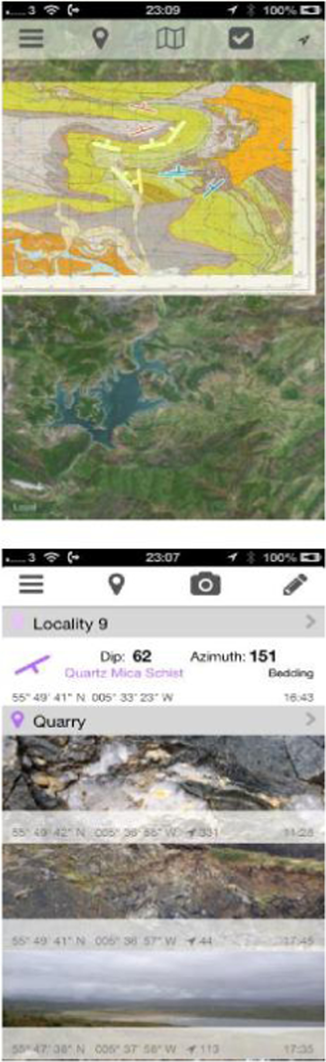
FieldMove Clino app on the Iphone showing the data collection page. Screen shots from the map and note book pages with in the app. Acknowledgment images from Knapdale, Scotland. Base map BRITISH GEOLOGICAL SURVEY. 1996. Knapdale. Sheet S028E. Solid and Drift Map. 1∶50 000
Selenium & tellurium mineralisation in metamorphosed red beds, Munster Basin, Ireland
S. C. Spinks 1, J. Parnell 1, A. Costanzo 2, M. Feely 2.
1Department of Geology & Petroleum Geology, University of Aberdeen, AB24 3UE, UK (sam.spinks@csiro.au)
2Earth and Ocean Sciences School of Natural Sciences, National University of Ireland, Galway, Ireland
Selenium and tellurium are scarce elements which are identified as being of critical importance for the development of environmentally-sensitive power generating technologies (Moss et al., 2011). Selenium mineralisation in sedimentary basins is strongly redox-controlled, generally at temperatures below 150°C, with many Se deposits occurring in red bed ore systems such as roll-front deposits (Simon et al., 1997). Hydrothermal mineralisation of selenium derived from magmatic activity, however, is characterised by much higher temperatures (Spooner, 1993). Tellurium, while less abundant than selenium, also often mineralises in oxidative non-magmatic veins at relatively low temperatures below 250°C (Afifi et al., 1988), and up to 400°C in magmatically-derived systems (Afifi et al., 1988; Cook and Ciobanu, 2005). Thus there is a generalised model of Se/Te mineralisation at low temperatures from highly oxidising fluids, and at high temperatures from magmatic sources. Here we investigate whether SEe/Te mineralisation occurs in metamorphosed red beds where the thermal history is high but the metalloids do not have a magmatic origin
The Devonian red bed-hosted polymetallic quartz veins in the Munster Basin of SW Ireland, which were formed through the metamorphic remobilisation of stratigraphically-proximal stratiform copper sulphide mineralisation during the Hercynian [Variscan] Orogeny (Ni Wen et al., 1996) were identified as a good target for study. Upon examination of the mineralised veins, several polymetallic mineral phases of selenium, tellurium and gold were identified as inclusion assemblages within the chalcopyrite-quartz copper ore. The assemblages include mineral phases of lead selenide, silver selenide, bismuth selenide, silver telluride, bismuth telluride, native tellurium, native gold, electrum, and gold–silver rich selenide and tellurides. Recent microthermometric studies of quartz from Hercynian polymetallic veins in the Munster Basin yield uncorrected homogenisation temperatures of 120 to 310°C and salinities ranging from 10 to 21 eq. wt-% NaCl.
This assemblage of high-temperature Se/Te/Au mineralisation is comparable with those found in magmatic-related systems such as those in the Dalradian terrane of Ireland and Scotland (Pattrick et al., 1998; Parnell et al., 2000). The selenium–tellurium–gold mineralisation in metamorphosed red beds also has implications for the potential for gold mineralisation in sedimentary basins. In addition to the Devonian and Dalradian, selenium and/or tellurium minerals are also found in Carboniferous black shales, Permo-Triassic red beds and Holocene peat of Ireland, making Ireland suitable for in-depth studies of selenium and tellurium concentration and deposition.
The origins of hydrothermal graphite in mesothermal gold deposits, focusing on the Macraes mine, New Zealand and the White River Prospect, Yukon, Canada
B. E. Staniforth 1, G. R. T. Jenkin 1, D. Craw 2.
1Department of Geology, University of Leicester, LE1 7RH, UK (bs146@le.ac.uk)
2Department of Geology, University of Otago, New Zealand
Gold and graphite have long been associated with each other in mesothermal deposits worldwide (Dissanayake and Rupasinghe, 1992), however there has often been little work into the nature of this association. Through a better understanding of the gold and graphite enrichment processes in these areas, we can make further advancements concerning exploration in graphitic terrains, by answering questions such as; does the association begin late or early on in the deposition process and whether the presence of the C–O–H fluid capable of precipitating graphite is responsible for gold enrichment.
There are three major sources of carbon in natural graphite; carbon sourced from organic material, carbonate carbon and carbon sourced from the mantle (magmatic origin, Luque et al., 2012), and all have different carbon isotope signatures. However, these can be difficult to interpret due to fractionation effects and mixing of fluids and source material during deposition processes. As well as the source, the mechanism of deposition of graphite needs to be taken into consideration. Graphite can be deposited either by the transformation of relic carbon source material in the rock (graphitisation, Landis, 1971), or as a precipitate from a carbon-based fluid (Luque et al., 1998). The latter requires a change in condition (T, P or ƒO2 change) to evoke nucleation and precipitation. Nucleation can also be achieved via mixing with C-bearing fluids, hydration or the presence of certain reducing sulphide and oxide minerals (Luque et al., 2012; Luque et al., 1998). In some cases, such as in Sri Lanka (Dissanayake and Rupasinghe, 1992), both metamorphic and fluid deposited graphite are seen overprinting each other.
In terms of association, Dissanayake and Rupasinghe (1992) and Pitcairn et al. (2005) suggest the deposition of gold in such areas is related to the presence of hydrothermally deposited graphite, as opposed to metamorphic. Dissanayake and Rupasinghe (1992) go on to suggest that the association could rely on the movement of fluids containing both gold and carbon, with the graphite in the hot fluid acting as an activated carbon that then absorbs the gold onto its surface.
The aim of this research is to investigate and constrain the source of hydrothermal graphite associated with gold mineralisation in metamorphic terrains. Carbon isotope analysis will be used on a number of gold–graphite occurrences in metamorphic terrains. The main focus of the project is on the Macraes gold mine in Otago, New Zealand and the White River prospect in Yukon, Canada; however, literature data from graphite deposits worldwide will also be examined. This data, along with the morphology and textural relationships of the deposits, will be used to provide a hypothesis for the source of the carbon. With this further information the relationship of gold and graphite will be investigated in further detail to begin answering some of the questions posed.
The initial carbon isotope samples from the White River prospect give an average δ13C V-PDB value of −28·4%, this is in line with the literature and supports an organic origin for the fluid.
Evolution and sulphur sources at the Muratdere Cu–Au porphyry deposit, Turkey
K. A. Sullivan 1, S. Roberts 1, J. Naden 2, P. Lusty 2, A. Boyce 3.
1Ocean and Earth Science, National Oceanography Centre, University of Southampton, Southampton, SO14 3ZH, UK (k.sullivan@noc.soton.ac.uk)
2British Geological Survey, Environmental Science Centre, Nicker Hill, Keyworth, Nottingham, NG12 5GG, UK
3Scottish Universities Environmental Research Centre, East Kilbride, Glasgow, G75 0QF, UK
The Muratdere deposit is a Cu–Au porphyry system in western Turkey with significant Mo, Ag, Te and Re credits. It is located 250 km west of Ankara, and is a joint venture between Lodos Madencilik and Stratex International Plc. with an average grade of 0·36% Cu, and 0·12 g t–1 Au with a JORC-compliant inferred resource of 186 000 tonnes Cu, 204 296 oz Au, 3·9 million oz Ag, 6390 tonnes Mo and 17 594 kg Re (Stratex International Annual Report, 2012). The deposit is located in the North Anatolian Belt, a pre-Jurassic subduction complex associated with the closure of the Tethyan Ocean (Tekeli, 1981), which contains ophiolitic melange units incorporating limestone blocks and ultramafic lenses. The Muratdere deposit is hosted in a suite of Palaeocene−Eocene granodiorite intrusions which intrude this melange, with a strike length of 4000 m and width of 200 m. The granodiorite predates the mineralisation and is intruded by later, syn-mineralisation quartz-feldspar porphyry intrusions.
Core logging and optical microscopy revealed several generations of veins and mineralisation, associated with extensive potassic alteration and a grade destructive propyllitic overprint at depth. The first mineralised vein set, V2, is associated with the majority of the Cu–Au mineralisation and is composed of quartz with pyrite-chalcopyrite centres. Veinset V3 is composed of quartz and dendritic molybdenite, and contains the Mo and Re mineralisation. The remaining mineralised veinset, V5, is polymetallic and contains sphalerite, galena, pyrite-chalcopyrite, and barite with increased values of Ag, Au and Te. Disseminated chalcopyrite is also present replacing pyrite in the host porphyry, and is sometimes associated with disseminated molybdenite, which is earlier than the dendritic molybdenite observed in V3. LA-ICP-MS analysis of these molybdenite generations found that both morphologies show a comparable Mo concentration, however the dendritic molybdenite has higher concentrations of Re with an average of 723 ppm and a maximum value of 3624 ppm, while the disseminated molybdenite has an average of 338 ppm, and a maximum of 734 ppm. Given the Re enriched molybdenite is only found in V3, and not in the disseminated sulphides, this suggests that the Re is derived from a different source to the Mo, possibly from ultramafic lenses in the surrounding melange.
The veinsets each show clear differences in their 34S signatures. V2, the main Cu–Au mineralising event, has 34S values of +2 to +8‰, while V3, the Mo–Re event, has heavier 34S values of up to +10‰. This contrasts with the host porphyry 34S of −2 to +6‰ and suggests some peridotitic influence (Chaussidon et al., 1989), which supports the hypothesis that the Re in V3 is scavenged from the ultramafic country rocks. V5 has much lighter 34S values of down to −4‰, which correlates with continental basement values (Chaussidon et al., 1989). This suggests either a deeper source for these sulphides, or the assimilation of sedimentary sulphur, perhaps from the limestone in the melange.
Cu–Mo–Au–Re partitioning and ore mineral solubility: T, P and fO2
B. C. Tattitch, J. Blundy.
University of Bristol, School of Earth Sciences, Wills, Queens Road, Bristol BS8 1RJ, UK (Bctatti@gmail.com)
The composition of arc magmas, associated magmatic volatiles phases, and the conditions during volatile exsolution are important controls on the potential for forming porphyry copper deposits (PCD). The efficiency by which ore metals are removed from the melt by these ‘proto-ore fluids’, the metal ratios in the fluid(s), the mass of metals available for transport, and ultimately the grade of deposits are likely affected by several key intensive variables. Previous experiments have shown that fluid salinity (Candela and Holland, 1984) as well as sulphur content (Simon et al., 2006) can strongly affect the partitioning of ore metals. In addition, more subtle parameters such as cation ratios (e.g Na/K/H (Zajacz et al., 2011)) along with melt ASI and H2S/SO2 ratios, may influence both Cu and Au. Our work has been focused on using experiments to constrain the independent role of these variables (T, P,
 O2,
O2,
 S2,
S2,
 HCl) in controlling porphyry ore deposit formation. While some of these parameters have been studied in the past, their influence on a suite of ore metals in equilibrium remains somewhat unclear.
In order to further approach the complexity of natural proto-ore fluids, we have performed CuFeS2–MoS2 saturated, Cu–Au–Mo–Re partitioning experiments using pumice from the Cardones Ignimbrite in northern Chile. These ore-mineral saturated experiments examine fluid-melt-crystal partitioning and ore mineral solubility for a magmatic system similar to those found in major PCD. These experiments were performed at 100 and 200 MPa and super-solidus conditions (810°C) in oxidised (NNO+2) and reduced (NNO+0·75) environments with respect to sulphur, as well as at near-solidus conditions (740°C and NNO+0·75). The vapour/melt partitioning of Cu decreases from reduced to oxidised conditions at 810°C (
 decreases from 40±20 to 10±5), whereas molybdenum partitioning remains constant (
 = 3±1 and 4±2 respectively). This corresponds to a change in the vapour Cu/Mo ratio from 40∶1 down to 1∶1. The decrease in
 is likely a result of the change from an H2S dominated fluid to an SO2 dominated fluid, changing available ligands. A change in Cu complexation is supported by the increased partitioning of Cu into coexisting brine, relative to vapour, with increasing
 O2 (
O2 (
 increases from 5±3 to 17±9). The effect of oxidation may be stronger for Cu relative to Au as the Cu/Au ratio in the vapour drops from 100∶1 down to 30∶1 at higher
 O2. At 740°C, near the solidus for the Cardones, the concentration of Mo increases in the fluid relative to Cu which stays nearly the same (Cu/Mo decreases from 40∶1 to 6∶1), indicating that the temperature of exsolution may fractionate Cu from Mo. Supercritical experiments (200 MPa) have recently been completed to evaluate ore-mineral solubility, and the influence of T and
 O2, for fluids of median salinity compared to vapours and brines at 100 MPa. These suites of experiments will allow us to evaluate complex ore metal behaviour during the progression of magmatic volatiles from one-phase systems (which likely represent initial volatile exsolution), through fluid unmixing into coexisting vapour and brine, continued exsolution down to the solidus, and finally sub-solidus transport and deposition. By evaluating changes to ore metal ratios (Cu/Mo, Cu/Au, Mo/) at magmatic conditions we can track trends in the ratios into the sub-solidus regime, and in so doing, obtain a means of bridging the gaps between magmatic exsolution, hydrothermal transport and ore mineral precipitation.
Opportunities and challenges for mineralogical and geological research on rare earth ore deposits
F. Wall.
Camborne School of Mines, University of Exeter, Penryn Campus, Cornwall TR10 9EZ, UK (f.wall@exeter.ac.uk)
The rare earth elements (REE, geologically usually considered as 15 elements La–Lu and Y) are perhaps the most well known of the critical metals. Following a dispute between Japan and China in 2010, the supply of REE from China was restricted, prices rocketed and need for REE in so many clean, digital and defence technologies was finally understood. The World's reliance on China and the security of supply risk made headline news.
There are however many potential additional REE deposits that could be exploited. They occur in a wide range of rocks and are distributed worldwide. The aim of this presentation is outline three important research challenges and to give examples of the state of the art of research on these deposits.
Improving the methods by which REE minerals can be concentrated and the REE extracted are the highest priority issues according to most REE exploration and mining companies. Outside of China, little research has been done in this area for many years. Monazite-(Ce) and bastnäsite-(Ce) are the most common ore minerals currently mined but new deposits contain a wide variety of minerals including synchysite, parisite, ancylite, eudialyte and florencite, which are often fine grained and highly intergrown (Fig. 1).
Crystals up to 30 cm long in rare earth-rich carbonatite, Wigu Hill, Tanzania were probably originally the REE-bearing mineral, burbankite, but they are now pseudomorphed by a fine-grained alteration assemblage including REE fluorcarbonates
Deposit models for REE are less sophisticated than for the more common metals, and there are several areas in which improved understanding would aid exploration. In particular, understanding fluid mobility of REE in and around igneous complexes is a key issue that would help to target the most valuable heavy REE.
Deciding which are the ‘best’ deposits from an environmental point of view is an interesting question because potential REE resources are diverse in nature, ranging from igneous rocks to mineral sands, deep sea deposits, weathered rocks, and by-products of fertiliser and aluminium manufacture. Each has different characteristics and potential environmental impacts. For example, unconsolidated beach sands, such as those currently mined for monazite in India, do not need comminution and thus can require only one third of the energy needed to process a hard rock carbonatite deposit. However, the monazite in beach sands contains typically several wt-% ThO2, making it radioactive and problematic to store, ship and process.
Acknowledgements: NERC catalyst award NE/L002280/1, Geology to Metallurgy of Critical Rare Earths.
Origin and fluid sources of Kalahari Copperbelt mineralisation, Botswana: Regional variations in mineralogy and structure at the Khoemaçau Cu–Ag project
A. M. Walsh 1, G. R. T. Jenkin 1, D. Catterall 2, A. J. Boyce 3.
1University of Leicester, University Road, Leicester, LE1 7RH, UK (aw235@le.ac.uk)
2Cupric Africa, Gaborone, Botswana
3Scottish Universities Environmental Research Centre, Rankin Avenue, East Kilbride G75 0QF, Scotland, UK
The Kalahari Copperbelt extends for 1000 km from southern Namibia along a NE–SW trend through to north-western Botswana (Borg and Maiden, 1989). It lies between the Neoproterozoic Damaran orogenic belt to the NW and older Proterozoic belts to the SW that border the Kaapvaal Craton (Modie, 2000). Copper–silver mineralisation is developed directly above the redox boundary between an upper reduced siliciclastic and carbonate sequence and lower oxidised red bed sandstone (Morgan et al., 2013).
The Khoemaçau (formerly Hana Ghanzi) Project is located within the 2000 km2 license area consisting of five blocks all owned by Cupric Canyon Capital that borders the Kalahari Game Reserve to the southeast.
The project aims to investigate any variations in mineralogy and structure between 6 zones of interest within the license area to further develop the current genetic model and geological understanding of the Khoemaçau project.
Previous work by Morgan et al. (2013) has suggested spatial variations in δ34S values between the zones. This has led to the development of the hypothesis that as a result of cooling and metal deposition as the mineralising fluid travelled out of a sedimentary basin a zonation pattern should be present between the zones of the deposit. This hypothesis will be tested by adding new data to existing work in various forms such as grades, metal ratios, trace element contents, mineralogy, alteration and isotopic composition for each zone. Analysis of the data will highlight any variations between the zones and determine whether it is the result of a controlling factor or factors.
Molybdenum has been identified in assays in concentrations up to 1·4%, but is not thought to be visible in hand specimen. Molybdenum concentrations appear to be highest in the relatively undeformed veins formed due to tensional failure within the hinge zones of folds. The location of molybdenum within the rocks and how it relates to the paragenesis of the deposit remains unknown. Previous work has suggested molybdenum formed during a different fluid phase to copper as there is little correlation in grade between the two and its low solubility in the chloride solutions thought to be transporting the copper (Gorman et al. 2013). Petrographic and SEM analysis on samples with high concentrations of molybdenum will be undertaken to locate the position of the molybdenum and determine under what phase it was deposited.
It is still unclear whether sulphides are formed by in-situ enrichment by copper rich fluids or dissolved, transported and re-precipitated where conditions become favourable. A study of disseminated and vein hosted sulphides will be conducted to investigate which case is true for the deposit.
Triggers for the formation of porphyry ore deposits in magmatic arcs
J. J. Wilkinson 1, 2,3.
1Department of Earth Science and Engineering, Imperial College London, Exhibition Road, London SW7 2AZ, UK
2CODES, University of Tasmania, Sandy Bay Campus, Hobart 7001, Tasmania, Australia
3Natural History Museum, Cromwell Road, London SW7 5BD, UK
Porphyry ore deposits provide much of the copper, molybdenum, gold and silver utilised by humankind. They typically form in magmatic arcs above subduction zones via a series of linked processes, beginning with magma generation in the mantle and ending with the precipitation of metals from hydrous fluids in the shallow crust. In this review, a hierarchy of four key ‘triggers’ involved in the formation of porphyry deposits is outlined (Wilkinson, 2013). Trigger 1 (102–103 km scale) is a process of cyclic refertilisation of magmas in the deep crust (e.g. Loucks, 2012). Trigger 2 (101–102 km scale) is the process of sulphide saturation in magmas that can both enhance and destroy ore-forming potential (e.g. Alt et al., 1993). Trigger 3 (100–101 km scale) relates to the efficient transfer of metals into hydrothermal fluids exsolving from porphyry magmas, in particular the potential role of melt reduction (e.g. Sun et al., 2004). Trigger 4 (∼100 km scale) identifies processes that are currently thought to be critical for the efficient precipitation of ore minerals in the deposit environment (e.g. Landtwing et al., 2010). Although all processes are required to a greater or lesser degree, it is argued that trigger 3, as an over-riding mechanism, can best explain the restriction of large deposits to specific arc segments and time periods. Consequently, recognition of the fingerprint of sulphide saturation in igneous rocks may help mineral exploration companies to identify parts of magmatic arcs particularly predisposed to porphyry ore formation.
LA-ICPMS pyrite trace elements and fluid inclusions constrains on the genesis of Xinqiao and Wushan stratiform massive Cu deposits, Middle and Lower Yangtze River Mineralisation Belt, China
L. Yang 1, 2, L. Jianwei 2, D. Selby 1.
1Department of Earth Sciences, Durham University, Durham DH1 3LE, UK (li.yang@durham.ac.uk)
2Faculty of Earth Resources, China University of Geosciences, Wuhan 430074, China
Massive sulphide Cu deposits along the Middle and Lower Yangtze River Mineralisation Belt (MLYMB) make a significant contribution to base metal reserves for this belt, and are regarded as one of China's most important Cu–Fe producer in the past three decades.
These deposits are characterised by their stratiform occurrence in the unconformity between later Devonian sandstone formation and Carboniferous limestone formation. The orebodies are normally dominated by pyrite and pyrrhotite, lack silicate minerals, only possess weak sericitisation. Mid-Mesozoic magmatism has caused extensive alteration, which is clearly indicated by the silicification and marmarisation of sandstone and limestone, respectively. Around these massive sulphide deposits, several large porphyry and skarn Cu (e.g. Wushan, Chengmenshan, Xinqiao and Datuanshan and Dongguashan) deposits have been mined for decades (Pan and Dong, 1999; Gu et al., 2007).
Based on the mineralisation styles, some workers suggest a submarine sedimentary origin with a later overprint and ore enrichment by mid-Mesozoic intrusions Lianxing (Gu et al., 2007; Khin et al., 2007). Other workers claimed these massive sulphides deposits are a result of the mid-Mesozoic magmatism and regard them as an end member of the mid-Mesozoic carbonate replacement deposits system (Pan and Dong, 1999). As a result, these different genetic models have led to different exploration activities.
Xinqiao and Wushan are representative deposits of stratiform massive sulphide deposits in MLYMB. Our fluid inclusion data confirm the quartz-pyrite veins in the Late Devonian Wutong Sandstone Formation underlying the Xinqiao stratiform orebody formed in association with high temperature fluids (boiling fluid inclusion groups indicate a 300–400°C trapping temperature), and suggest these veins are magmatic related rather than a feeder zone in submarine mineralisation system. LA-ICPMS in-situ trace element data shown the pyrite in stratiform orebody are enriched in Cu and As, which has similar trace elements as the pyrite in the skarn orebody. The pyrite from sedimentary rocks is slighted enriched with Na, Ca, Mn with significantly higher As concentrations.
Our research suggests the Wushan and Xinqiao deposits, as well as other stratiform massive sulphides ore deposits are end members of the mid-Mesozoic carbonate replacement deposits system. As the result, we suggest the exploration work for stratiform deposits should focus on the intrusions and pay more attention to the potential deep porphyry mineralisation.