
Abstract
Accumulation and lag concentration, together with dispersion, are important processes in offshore and coastal placer development. Mineral grains and sediment particles are sorted by flowing water according to their hydraulic equivalence. Distinct placer types are developed. Marine regression and transgression result in reworking leading to modification or destruction. Some placers are stranded on the coast, others are drowned. A vertical grade profile (VGP) graphically depicts the grade variations in the pay section of a placer. A VGP may be plotted for all heavy minerals and every placer type, and two basic patterns are evident. An upward or downward decline in grade indicates that accumulation and lag processes, respectively, were dominant. A reversal in decline direction marks a scour horizon or stillstand. Combinations of the basic patterns exist and some are complex with three grade maxima, revealing multiple mineralisation units. The history of a placer is revealed by its VGP(s) unless part is erased by reworking. Plotting the grade to a common logarithmic scale may assist interpretation. Different placer types have been developed in favoured locations visible on model cross-sections through the coast to the offshore. With minor variations, the VGP pattern displayed by a specific placer type is common to all minerals. Sampling protocol and resource estimation procedures should be guided by the VGP.
Introduction
During the early 1960s, several mining companies operated approximately 65 bucket-ladder dredges and many open-pits on Malaysian, cassiterite-bearing tin placers. In two such companies attempts were being made to improve ore reserve estimation methods. The objective was to provide a better forecast of the percentage recovery of the estimated grade achievable during production (Broadhurst and Batzer, 1965). The pattern of vertical grade variation appeared to be one of the factors influencing the recovery (Garnett, unpubl., 1964). The in situ grade was never constant. It declined either upward or downward from the bedrock or ground surface, respectively, or from intermediate horizons. Combinations and repetitive patterns existed, especially in the more extensive placers. The individual details were indicative of the manner of formation of the placer. The term vertical grade profile (VGP throughout this paper) was used to describe the plot of grade variability in the vertical dimension of placers being dredged by Tronoh Mines Ltd in the Kinta Valley.
A nearby placer on limestone bedrock was then being drilled and evaluated. The VGPs of the deposit were examined in conjunction with a rudimentary analysis of the tin grade frequency distributions at successive ∼1·5 m elevations. The distributions suggested the existence of three distinct tin-bearing units. Each unit was characterised by a different grade population and by features affecting the recovery of cassiterite. Subsequent statistical work confirmed that the units were present (Clark and Garnett, 1974). VGPs were then used on a variety of tin placer types being explored and mined offshore from southern Thailand.
Placers of both non-marine and marine origin are targeted in offshore and coastal environments for their content of precious metals, tin, diamonds, and other heavy minerals. Their more diverse origins and any subsequent modifications result in a greater variety of VGPs than is displayed by onshore placers.
There are few published examples of VGPs, one such being of some onshore gold placers (Goldfarb, 2007). Others have been interpreted in geomorphological terms (Lintern, 2005). Coastal forms have been identified from the VGPs of palaeoplacers containing heavy minerals (Patyk-Kara et al., 1999). Published VGPs also are available for heavy minerals in Australia (Roy, 1999), offshore Mozambique (Kudrass, 1987) and for a tin placer sited in Ringarooma Bay of Tasmania in Australia (Davies, 2009).
Definitions
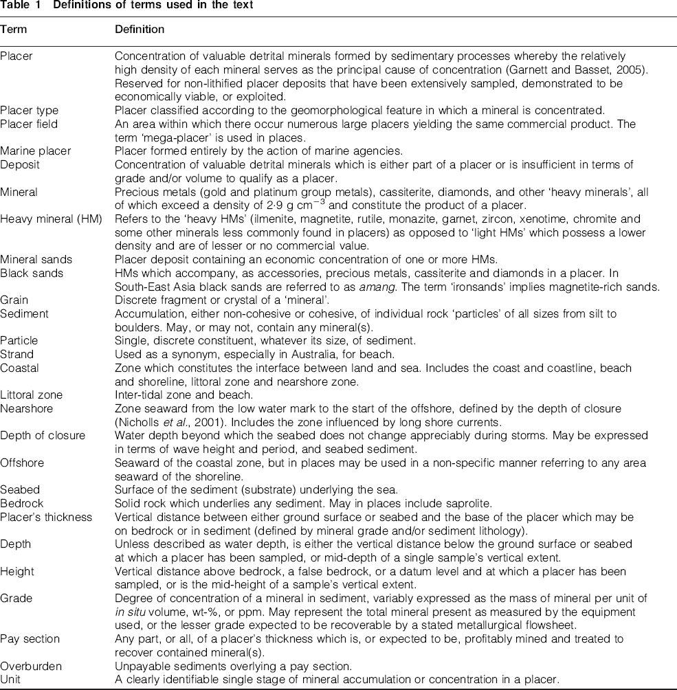
To avoid any uncertainty, various terms employed throughout the text are defined in Table 1. It is recognised that there are alternative definitions of some of the terms in the literature, e.g. for coastal, littoral, nearshore, offshore and depth of closure.
Definitions of terms used in the text
Placer types
Five groups of placer types exist in offshore and coastal areas:
placers formed in the littoral zone and nearshore
marine placers formed in the nearshore and offshore
drowned placers formed on the shore, now seaward of the shoreline
drowned non-marine placers, now seaward of the shoreline
stranded placers formed as a beach or in the nearshore, now above sea level.
Some or all may have formed in a major, placer-hosting offshore and coastal area. Each group contains a variety of placer types most easily defined by their geomorphological form. Some placer types are confined to only one or two groups. Others are more widespread. All owe their origin to some combination of accumulation, lag and dispersion processes (Garnett and Bassett, 2005).
Minerals are introduced into the offshore and coastal zones by fluvial transport and by erosional liberation from coastlines (Fig. 1). Where subjected to flowing water they may be transported and sorted according to their hydraulic equivalence, a combined measure of size and density (Slingerland, 1977). The component particles of non-cohesive sediments behave in a similar manner. The morphology of a very fine-grained mineral, especially of gold, is an additional factor in defining its hydraulic equivalence. Sorting leads to concentration, with or without significant prior dispersal.
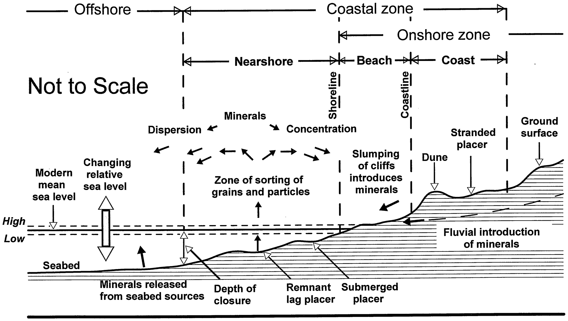
Cross-section through the offshore and coastal zones to illustrate some of the terms defined in Table 1
The critical hydraulic equivalence above or below which a particle or grain becomes entrained or settles varies with time and place, governed by the prevailing energy conditions. Grains and particles of less than a critical hydraulic equivalence are entrained and transported seaward or alongshore. An eventual reduction in energy allows selective settling of the grains. A proximal or distal accumulation placer is formed by these processes. The grade declines upward from the base of accumulation if diminishing energy allows increasingly lighter particles to settle. Coarser grains tend to accumulate in, or very close to, beaches (Komar, 2007). Some are concentrated in the swash zone (Komar and Wang, 1984). Exposed, irregular bedrock and coarse gravel layers may provide trap sites for migrating minerals.
Minerals are also released by seabed erosion from exposed bedrock sources and by winnowing from any mineral-bearing assemblage of sediment. A lag concentration of remnant mineral grains is left on the bedrock or among the uppermost particles of the remaining sediment. Within the latter the grade declines downward from the surface. Any coarser, immovable particles may form a protective barrier, as a remnant lag gravel, to inhibit further winnowing. In practice a dominant accumulation process incorporates some lag action. A dominant lag process, likewise, involves some accumulation. A discrete unit results from the uninterrupted operation of each dominant process.
Placers formed in the above manner were both modified and destroyed by marine regression and transgression. Marine transgression, as opposed to regression, tended to increase the number of units in a vertical section. Coastline faulting and warping, cyclic glaciation and erosion were important in areas of uplift (Kudrass, 2000). Repetition of supply, multiphase accumulation, scouring and reworking by the lag process in places rendered a placer complex or changed it beyond recognition. The grade of an accumulation placer may have been increased and its thickness decreased by scouring and reworking by the lag process. That of a lag placer could have been decreased and its thickness increased by superimposed accumulation of lower grade sediments. Many placers now owe their economic grade and mineral content, even their existence, to reworking.
Vertical grade profile (VGP)
A VGP depicts the variation in incremental grade for any number of equal or unequal, contiguous, vertical increments relative to depth or height within the placer. The abscissa represents the grade. The vertical interval used for a VGP usually ranges from 0·25 to 1·00 m. Consistency of interval within a single VGP is not essential. The lowest interval is defined by the minimum vertical sampling interval employed. It may have been designed to assist in determining the required mining selectivity. However, a problem arises if any of the units comprise stacked, mineral-rich strata possessing thicknesses less than 0·25 m. They and their intervening less mineralised layers are consolidated within a vertical interval which exceeds the thickness of each. In the absence of any explanation a package of strata therefore may be indistinguishable on the VGP from disseminated mineralisation over the same vertical interval. In addition, some drilling systems may contaminate underlying unmineralised strata with mineral grains entrained from above. A tail of recorded grades, referred to as drag ore, results. The data falsely indicate that mineralisation extends in depth. Care must be exercised in interpretation.
The source of data for the derivation of a VGP may be a single drillhole. However a more representative VGP for the domain of a mineral may require the averaging of data from a group of adjacent drillholes. Too wide an areal spread should be avoided until lateral uniformity is established. VGPs of contiguous areas in a placer may show very different results which reflect localised energy variations. Experimentation may be necessary. Several representative, but significantly different, VGPs may be revealed in a single placer. Thicker placers frequently possess the most complex VGPs. Specific placer types possess characteristic VGP patterns showing the direction in which grade declines: upward or downward. A pattern reveals the presence of one or more units.
Vertical grade profile patterns
Two basic patterns, and others, evident in all VGPs of offshore and coastal placers are represented by models (Fig. 2). The grade declines either upward (Fig. 2A) or downward (Fig. 2B). The basic ones contribute to an additional four patterns (Figs. 2C, D, E and F). Each of the six is associated with one or more of the placer types, but exceptions occur. A sudden change in direction of grade decline may indicate a scour horizon or a stillstand. Changes in the rate of decline may be caused by the short term intrusion of either lag or accumulation in the prevailing, otherwise dominant process. Some VGPs exhibit a complex, vertical combination of repeated patterns which result from several changes, usually increases, in relative sea level.
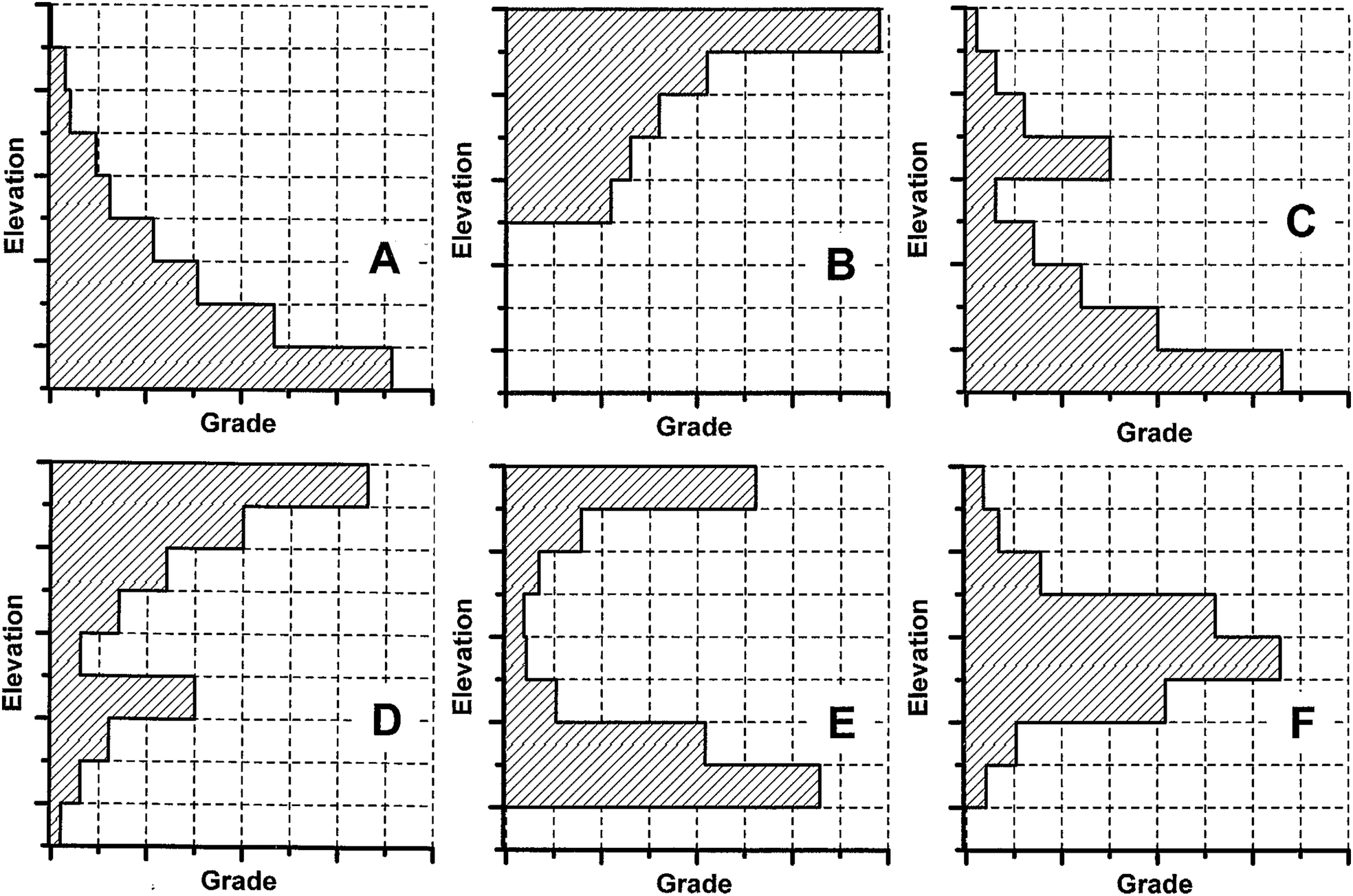
Six drawings illustrating model VGP patterns. a basic, single upward decline; b basic, single downward decline; c repeated upward decline; d repeated downward decline; e combination of A followed by B; f combination of B followed by A
Logarithmic grade decline
Grade variation may be depicted graphically as a line chart or a bar chart (Fig. 3). However, a decline in heavy mineral (HM) grade of a dispersion placer has been noted to be logarithmic (Berquist and Hobbs, 1988) and a ‘reversed exponential discipline’ of offshore tin grade was recorded by Kudrass and Schlüter (1994). Many grade populations also approach log-normality. Using a common logarithmic (log10) scale for the abscissa of the VGP (VGPlog) has proved informative for all minerals and most placer types.
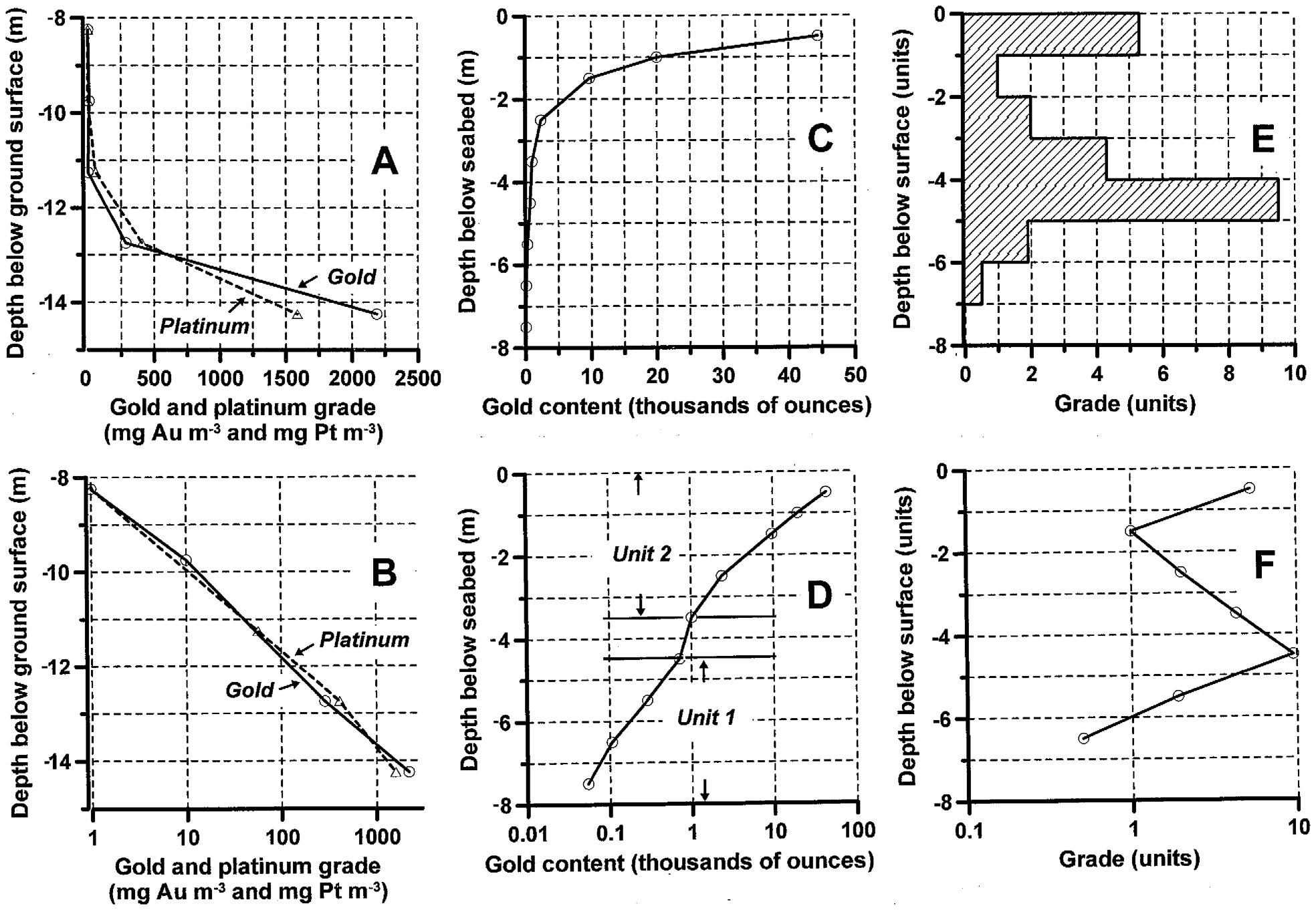
Three examples of the results of plotting the common logarithm (log10) of the grade (VGPlog). a, b precious metal-bearing beach in Ecuador. Based on one representative drillhole; c, d two glacio-fluvial, gold-bearing units in the nearshore at Nome, AK, USA. Based on numerous drillholes; e, f nearshore HM placer, Indonesia. Confidentiality prevents disclosure of the HM grades. Based on one representative drillhole
A single unit (Fig. 3A) is frequently represented by a straight line on a VGPlog (Fig. 3B). Subtle changes may indicate the presence, otherwise unsuspected (Fig 3C), of more than one unit (Fig. 3D). Two of three lines on a VGPlog, each representing an individual unit and its rate of grade decline (Fig. 3F), exhibit parallelism which is not obvious on a bar chart (Fig. 3E). Parallelism is not indicative of equal rates of decline.
If a lag event immediately follows accumulation, or vice-versa, the VGP displays a rapid change in decline direction, in grade, and in rate of grade change (Fig. 4). An upward decline reveals that the accumulation process was dominant. A relatively steep decline may indicate that the less dominant lag process also operated to maintain a high grade. A downward decline is created by a dominant lag process during an influx of accumulating sediment and mineral. Rate of decline may reflect the prevailing energy levels and their rate of decay. Sharp reversals in the direction of decline result from a scour horizon or stillstand. Histograms of regional seabed bathymetry and bedrock elevation may support the latter interpretation.
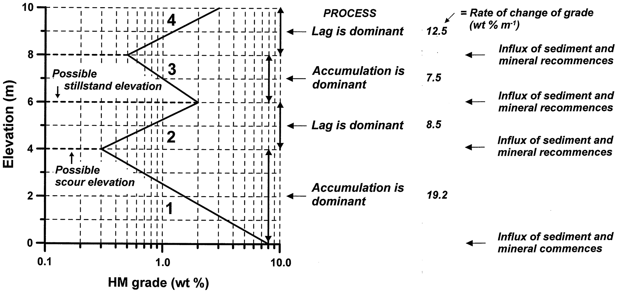
Model VGPlog with interpretations of grade minima and maxima, and grade decline directions for four numbered units
Each form of chart, bar, line and VGPlog, may be more appropriate for different data sets and their interpretation. All three forms are referred to in the remainder of the text as a VGP.
Lithologic control
Individual minerals tend to accompany particular sediment lithologies. Sudden grade changes coincide with lithologic boundaries. The mineral grain size may also display a direct or inverse relationship with sediment particle size. A VGP therefore ideally is viewed alongside any changes in the granulometry of the host sediments (Fig. 5). Gold (density = 15·4–19·4 g cm−3) was usually concentrated to a commercial extent in high energy gravels, although fine dispersed gold may exist in sands and, less commonly, in finer sediments. Cassiterite (density = 6·8–7·1 g cm−3), being brittle, quickly reduced in size during transport, usually is hosted by sediment ranging from fine sands to pebbles. Diamonds (density = 3·5 g cm−3), with a size of approximately 4 mm (around 0·25 carats/stone, or 0·05 g/stone) and higher, are normally found associated with gravels or at their interface with sand. However, diamonds are found in sand alone and, very rarely, in finer sediments. Heavy minerals (density = 4·2–7·0 g cm−3) generally are concentrated in sands and silt.
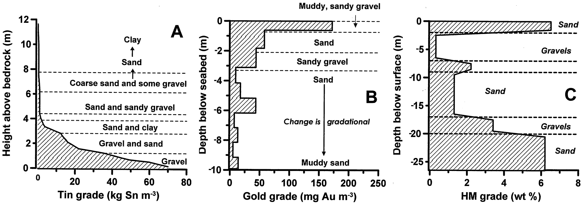
VGPs illustrating the lithologic influence on grade. a nearshore tin placer, southern Thailand, with upward declining cassiterite grade. Based on several drillholes; b offshore gold placer, West coast, South Island, New Zealand. Modified after Lew and Corner (1990); c HM placer in the littoral zone, Peru. Interpretation based on published sampling data (Latin Resources Limited, 2012)
Effect of mineral grain size
The relationship between mineral grade and grain size may be both direct and inverse within different units of the same placer. Therefore the pattern of a VGP may depend on whether the total mineral content, or only a particular size fraction, is reported (Fig. 6). A suite of heavy minerals of different density and range of grain size invariably exhibit very different directions and rates of decline.
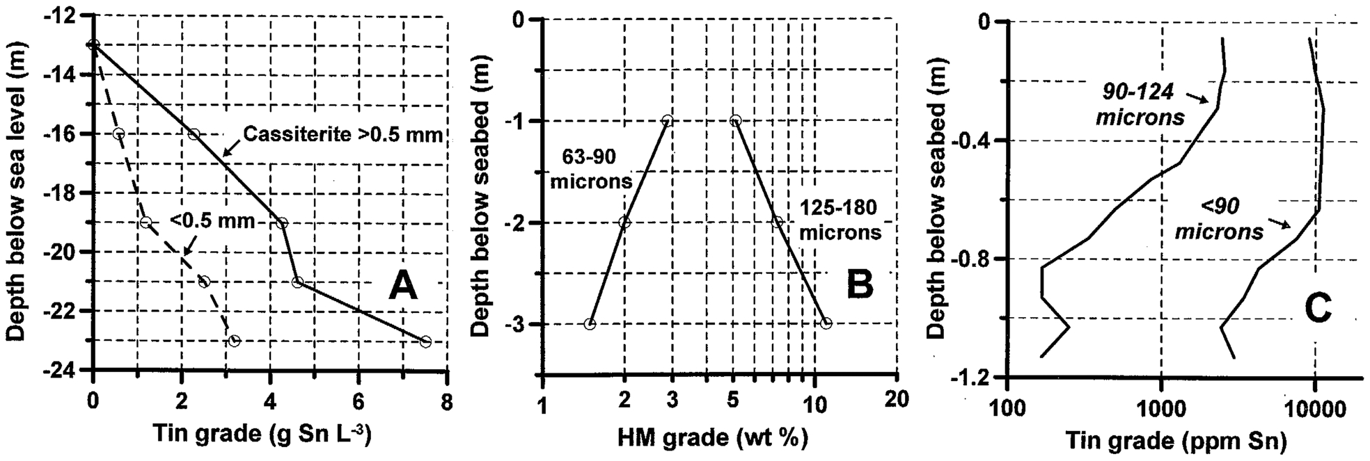
VGPs illustrating the effect of mineral grain size on the rate and direction of grade decline. a cassiterite-bearing channel (gully) offshore Billiton Island, Indonesia, showing coarser cassiterite declining upward at 2·5 times the overall rate of finer grains. Based on data from Van Overeem (1960); b dispersion deposit showing opposing directions of heavy mineral grade decline exhibited by different size fractions of grains. Based on data from Hunter (1971); c dispersion deposit showing contrasting grades and rates of cassiterite grade decline exhibited by different size fractions of grains. Modified after Yim (1974)
Examples from major placer fields
For each mineral the various placer groups and types inhabit typical locations in the offshore and coastal zones of major placer fields. Four model cross-sections are drawn to represent a combination of two or more such domains for each mineral: gold (Fig. 7), cassiterite (Fig. 8), diamonds (Fig. 9) and heavy minerals (Fig. 10). Of several tabulated placer types, each exhibits for all minerals a significant similarity of VGP patterns. The patterns are listed, with reference to Fig. 2.
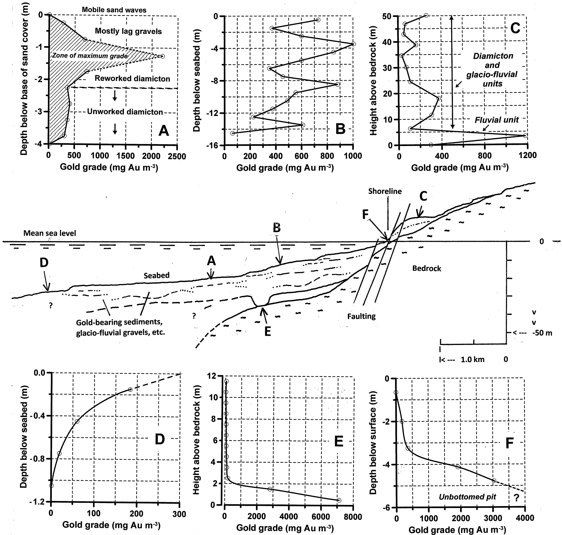
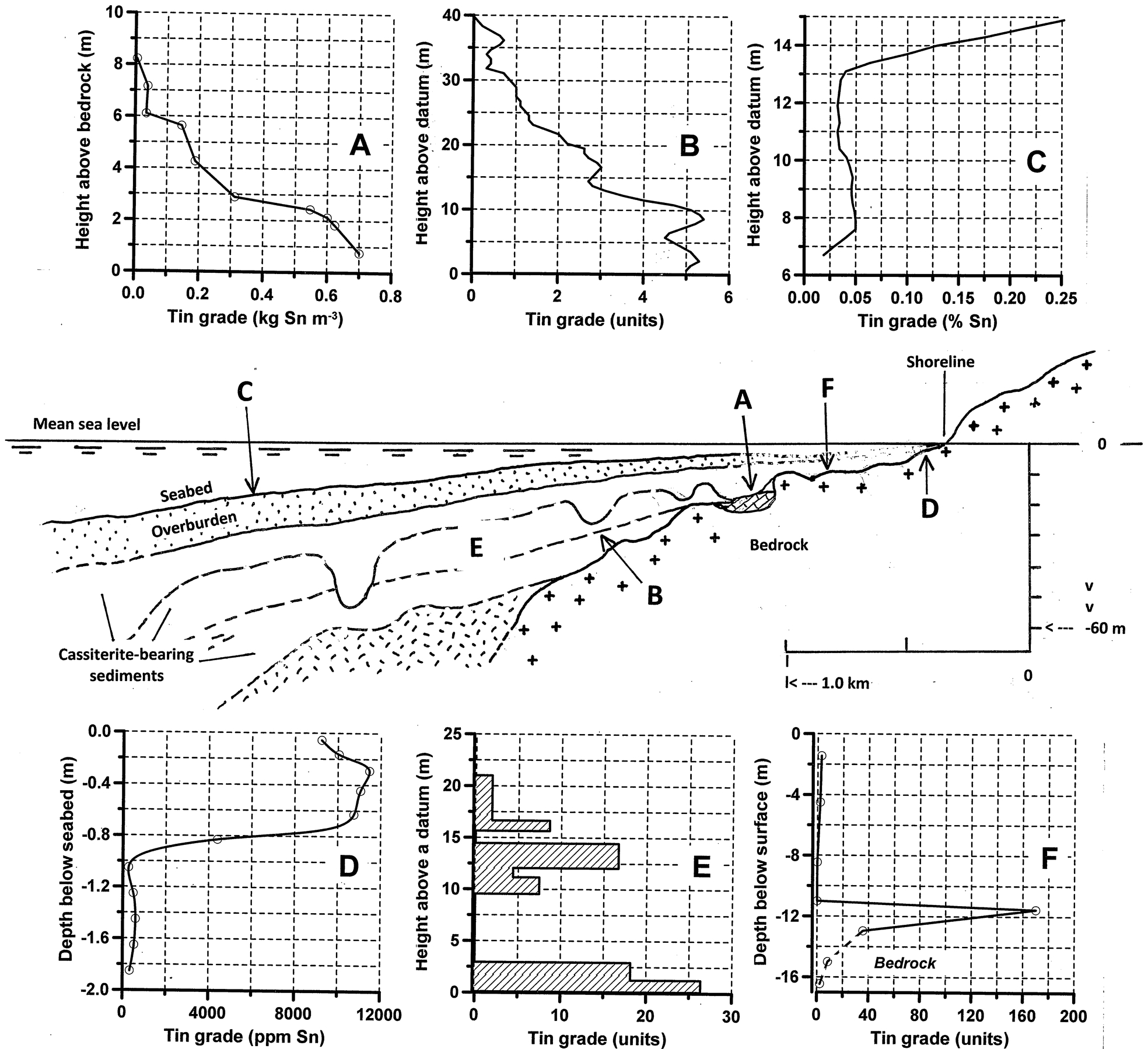
Cross-section through an offshore and coastal gold placer field with VGPs of some typical placer types. The cross-section represents Nome (Garnett, 2000a) and Chilean Tierra del Fuego (Garnett, unpubl., 2013). a remnant lag gravels in the nearshore, Nome. Based on numerous drillholes; b repetitive gold concentration in mobile lag gravels at stillstand elevations within partially eroded diamicton at Nome. Based on 91 grouped drillholes; c gold-bearing diamicton, separated by glacio-fluvial sand and gravels, and overlying the oldest unit of high grade fluvial gravels on bedrock, Lennox Island, Chilean Tierra del Fuego. Based on channel sampling of a cliff (Gaffri, unpubl., 1997; Garnett, unpubl., 2013); d dispersion deposit in the offshore, Nome. Based on an undisturbed sample; e buried channel of pre-glaciation Anvil Creek, Nome. Based on 12 closely situated drillholes; f back beach on Lennox Island, Chilean Tierra del Fuego. Based on a hand-dug pit (Gaffri, unpubl., 2013; Garnett, unpubl., 2013)
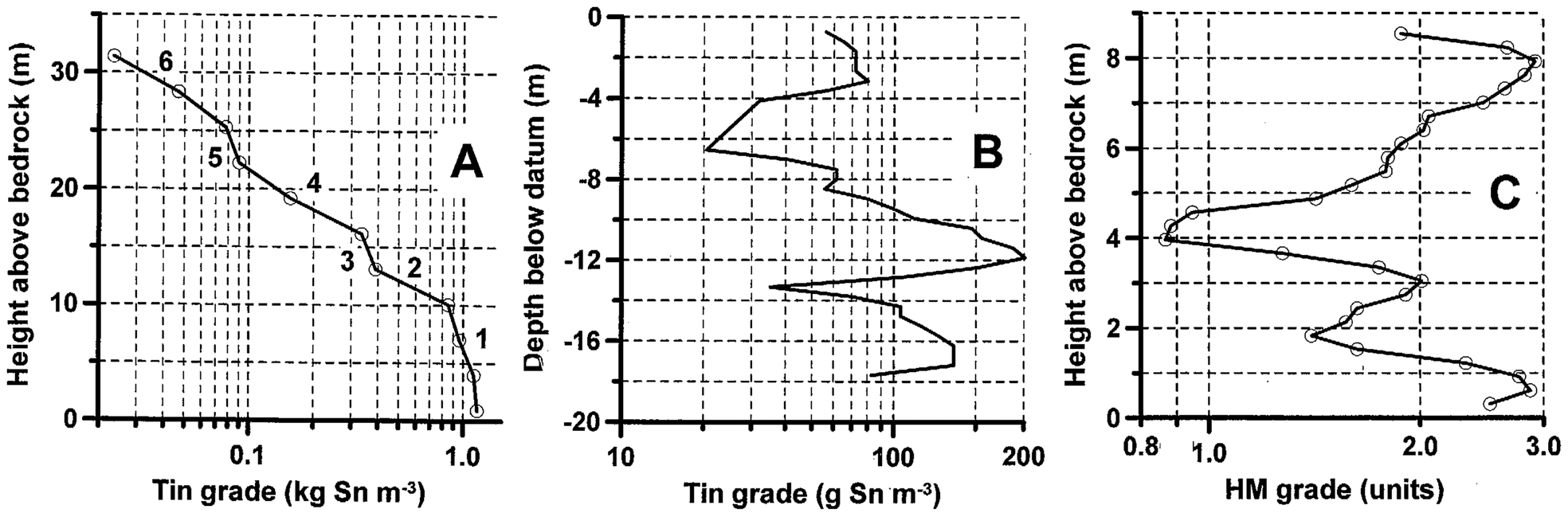
Cross-section through an offshore and coastal tin placer field with VGPs of some typical placer types: the cross-section represents Indonesia (Batchelor, 1979; Sundrijo, 1984), Malaysia (Ringis, 1983) and southern Thailand (Garnett, unpubl., 1973). a nearshore, combined channel and mobile lag deposit, southern Thailand. Based on multiple drillholes; b nearshore alluvial fan formed over a cassiterite-rich granite, Dindings district of West Malaysia. Interpreted from a cross-section showing five drillholes (Ringis, 1983); c beach, showing surface concentration of cassiterite, Gwithian, Cornwall. Interpreted from published data (Lee, 1968); d dispersion deposit offshore St. Agnes, Cornwall. Modified after Yim (1974); e two cassiterite-bearing units overlying an offshore channel placer, Laut Tempilang, Indonesia. Modified after Sundrijo (1984); f beach, showing basal concentration of cassiterite, Pantai Belo, Indonesia. Modified after Sundrijo (1984)
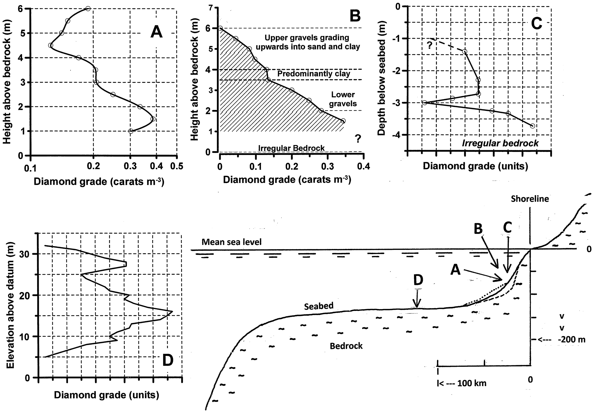
Cross-section through an offshore and coastal diamond placer field with VGPs excluding d, of some typical placer types. The cross-section represents the continental shelf offshore Namibia and South Africa. a offshore accumulation; b offshore accumulation (modified palaeobeach). Constructed, with a reasonable probability of being representative, and based on the results from numerous closely spaced sample sites; c offshore, infilled channel. Constructed in the same manner as B, showing two units of diamond-bearing gravels. Unquantified, higher grade sediment exists immediately above bedrock. Based on the results from numerous closely spaced sample sites; d deep water, offshore transgressive lag∼1 m thick. Confidentiality prevents disclosure of the diamond grades
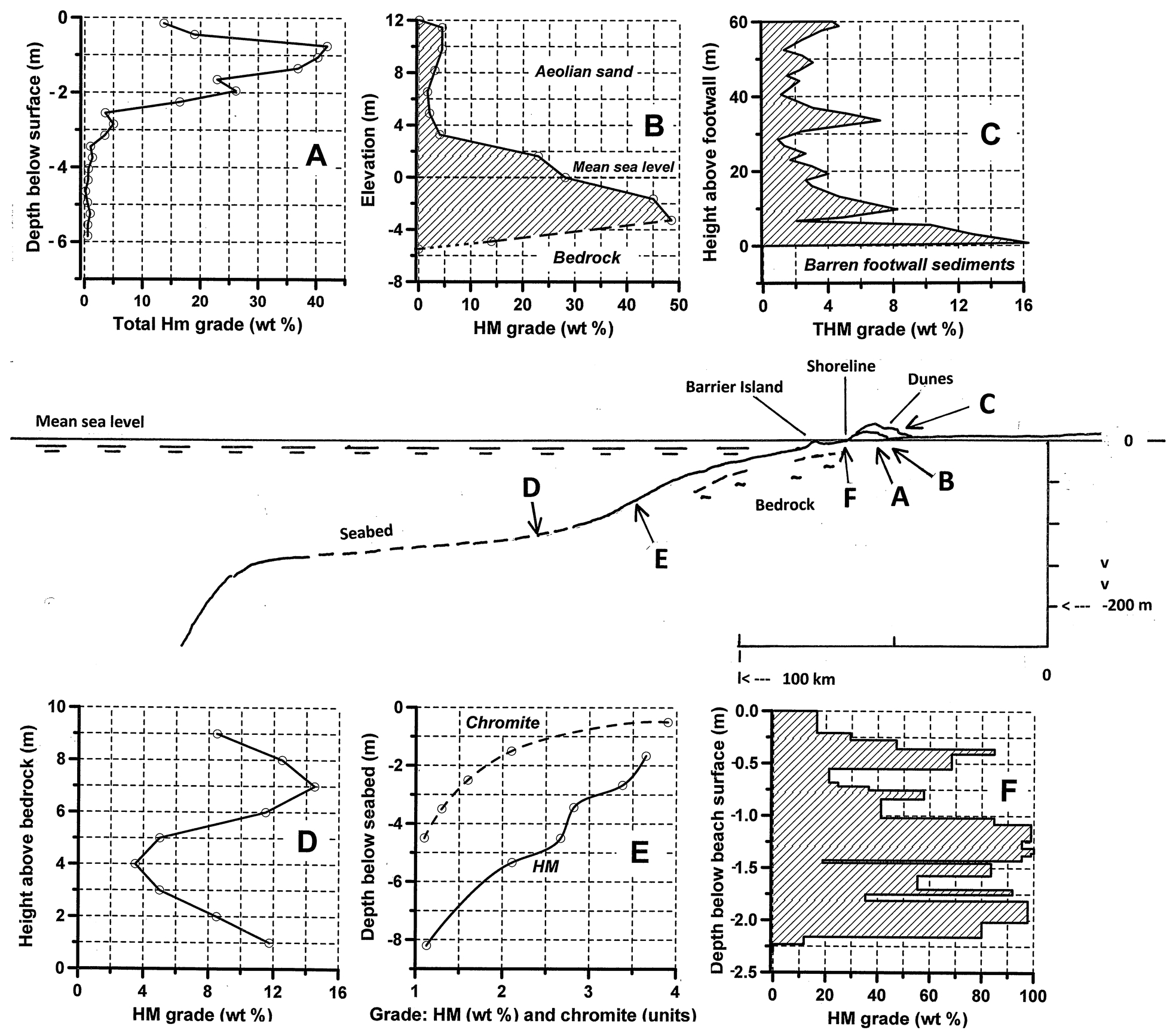
Cross-section through an offshore and coastal HM placer field with VGPs of some typical placer types. a relict strandline in southeastern Australia. Modified after Roy (1999); b strandline deposit in WA, Australia. Based on data from Shepherd (1990); c mineralised dunes, Richards Bay, South Africa, modified after Abzalov et al. (2011); d offshore concentrations on the Mozambiquan inner shelf. In any place either the upper or lower concentration is dominant. An interpretation of >60 core samples (Kudrass, 1987); e dispersion deposit, offshore VA, USA. Based on published data (Berquist and Hobbs, 1988). And dispersed chromite in the nearshore, Port Au Port, NL, Canada. Based on multiple samples. Confidentiality prevents disclosure of the chromite grades; f modern beach placer, Geelwal Karoo farm, Namaqualand, South Africa. Modified after MacDonald and Rozendaal (1995)
Some of the VGPs illustrated with each cross-section have been selected from the author's unpublished work between 1964 and 2013. They are supplemented by VGPs resulting from the author's subjective interpretation of limited, published, mostly numerical material. For a variety of reasons, including confidentiality and sampling difficulties, some placer types for certain minerals are not represented. Unless inhibited by confidentiality requirements all grades are stated in SI units.
Gold placer vertical grade profile
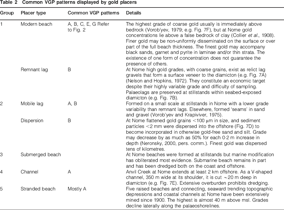
The offshore and coastal gold placers of Nome, Alaska in the USA, have been extensively explored and exploited since 1900 (Garnett, 2000a). Similar, less explored areas include the West coast of South Island, New Zealand (explored offshore and exploited on the coast), Chilean Tierra del Fuego (old, coastal artisan workings, and recently explored onshore) and Siberia. Together, they constitute the model cross-section for gold (Fig. 7). The four locations share an important feature: their extreme latitude. Glacial action eroded proximal and distal primary sources of gold. The mineral was transported in diamicton or coarse gravels to the coast and beyond the shoreline. Placers exist both above and below mean sea level (msl).
At Nome two units of diamicton and two terminal moraines extend well into the nearshore. They incorporate discontinuous remnants of pre-existing onshore fluvial placers, ice-rafted boulder fields, outwash gravels, and the products of marine reworking. Changes in relative sea level combined with high energy storms lead to the formation of several placer types, each represented by a characteristic VGP. During stillstands collapsing palaeocliff faces of diamicton released gold to the existing beaches and into dispersing currents. High grade remnant lags formed on seabed exposures of diamicton.
All economic mineralisation seaward of the modern beach is in less than 30 m of water. Western Gold Exploration and Mining Company Limited Partnership (WestGold) dredged offshore at Nome during the late 1980s (Garnett, 2000a). The depth limit of marine mining is dictated by the difficulty of excavating cohesive diamicton containing large clasts up to boulder size. Onshore deposits, especially parts of raised beaches which are now depleted, possessed the highest, consistent grades.
All five placer groups are represented to varying degrees of commercial importance (Table 2). On Lennox Island, Chilean Tierra del Fuego, two phases of glaciation and an intervening unit of fluvially reworked diamicton, all overlie an earlier, high grade fluvial unit. Elsewhere, worldwide, thin surface concentrations of gold have been recovered from beaches on an artisan scale.
Common VGP patterns displayed by gold placers
Tin placer vertical grade profile
The offshore and coastal tin placers of South-East Asia constitute the model for cassiterite (Aleva, 1973; Batchelor, 1979). They are part of the South-East Asian tin belt and comprise the deposits of the Tin Islands of Indonesia (Bangka, Billiton and Singkep), southern Thailand, and the Dindings district of West Malaysia. All lie on the micro-tidal, shallow water margins of the Sunda Shelf over which offshore water depths vary from approximately 30 to 120 m. The three placer fields contribute to the model cross-section (Fig. 8) and share an important feature in common. The tropical climate of their equatorial location has accelerated the alteration and erosion of low lying, coastal granites. These have released cassiterite for transport into the nearshore.
On the shelf an older alluvium comprising cassiterite-rich gravels overlies bedrock in a piedmont fan environment. The alluvium is overlain unconformably by younger flood plain deposits containing lower grade concentrations. Some channels were incised to 120 m below msl during falls in relative sea level (Batchelor, 1979). In places a youngest and widespread unit comprises overburden of mud and sands up to 30 m thick. Selectively eroded, karstic limestone provides very large, seabed trap sites for cassiterite-rich sediment. Elsewhere, exposed granitic bedrock carries thin, high grade mineral concentrations. Nearshore placers have been modified by monsoon storms in Indonesia and tsunamis in Thailand. All five placer groups and many placer types are represented to varying degrees of commercial importance (Table 3).
Common VGP patterns displayed by tin placers
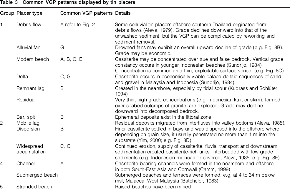
The offshore and coastal tin deposits of southern Thailand have been extensively explored and mined. From an initial venture in 1908, offshore dredging achieved its highest production in the 1960s and 1970s. Indonesian offshore dredging commenced in 1938 and continues as a major industry by PT Tambang Timah in water depths of up to 30 m. Future production increasingly will come from the nearshore and offshore. The mining limit will be determined by water depth, overburden thickness and pay section grade. Some exploration, targeting submerged channels and dispersion placers, has been conducted around the coast of Cornwall, England.
Diamond placer vertical grade profile
The Namibian and South African west coast is a unique placer diamond field (Bluck et al., 2005). It provides the model cross-section (Fig. 9). Fluvially transported diamonds from numerous, eroded kimberlitic sources in the hinterland entered the South Atlantic Ocean via several rivers (De Wit, 1999; Spaggiari et al., 2006). Some important conditions led to diamonds then being concentrated along the coastline of the two countries. Long period, high amplitude swells on the low gradient shelf combined with very high wind velocities on the exposed, micro-tidal coastline. These conditions created long shore currents which dispersed sediment particles and diamonds northward from the Orange River delta. Placers extend for over 200 km along the Namibian coastline (Garnett, 2000b).
Diamonds were deposited in the littoral zone on proximal barrier beaches, spits, wash-over deltas and more distal linear beaches (Oosterveld, 2003). They also settled in agitated, coarse gravels and were trapped by irregular bedrock surfaces. Finer diamonds were concentrated in more distant embayments and pocket beaches. Thin layers, now drowned, of mobile, diamond-bearing gravels formed over wide areas of exposed bedrock. Diamonds and sand were transported by wind off beaches and into onshore aeolian transport channels and salt pans which were subjected to desert deflation. Many transgressive and regressive events along the entire coastline caused repeated reworking and redistribution of all the placer types. They became, and remain, exposed, stranded and submerged over a vertical range exceeding 200 m. In places on the inner shelf the placers are buried beneath up to 14 m of mud. All five placer groups are represented to varying degrees of commercial importance (Table 4).
Common VGP patterns displayed by diamond placers
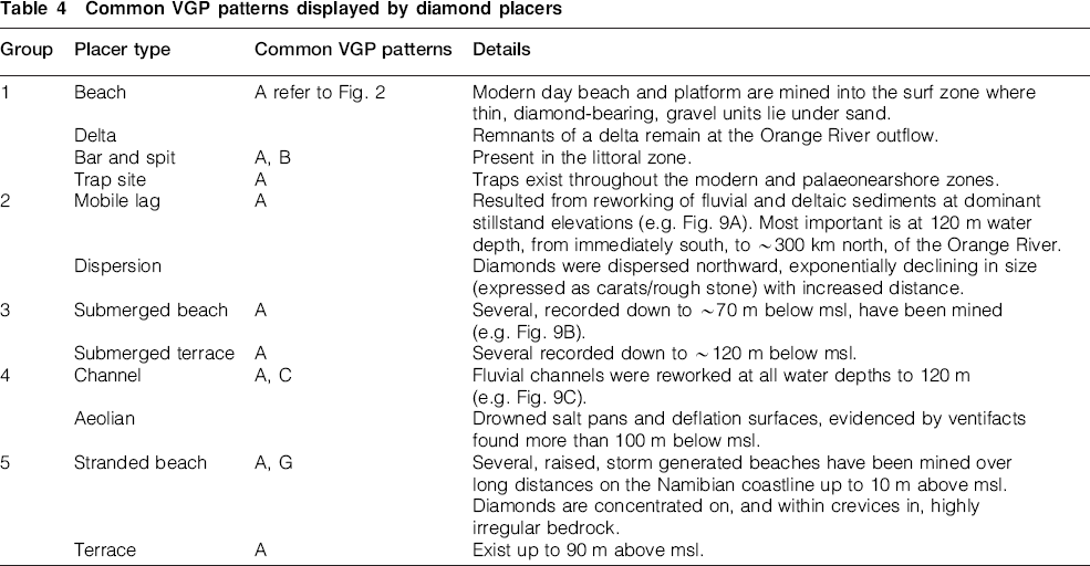
Representative VGPs are not easily obtained. Many of the units are very thin (y1 m) and the mineral (diamond) concentrations are the lowest of any placer. Some sampling systems may not recover all the diamonds off competent, irregular bedrock (Fig. 9C). Reliable data result from recording the number of diamonds recovered in large volume bulk samples or during production at different water depths (Fig. 9A).
Diamonds were first discovered on the Namibian coast in 1908. Raised beaches have been exploited ever since to yield over 100 million carats of gem quality stones. Mining of the nearshore placers was underway in the 1960s. In 1989 De Beers Marine commenced mining in the offshore at ∼120 m water depths. Production by Namdeb Diamond Corporation (Pty) Ltd has continued at that depth in the Namibian Atlantic 1 lease opposite the Orange River mouth and elsewhere. Other companies recover diamonds from shallower waters, including the surf zone, along the coastline of both countries. Annual, Namibian offshore production surpassed that from onshore in 2001, and by 2012 had reached 1·2 million carats per year.
Heavy mineral placer vertical grade profile
Placer fields exploited for heavy minerals (HM) are found in Australia (Roy et al., 2000; Hou et al., 2003), India and the eastern USA. Together, they form the model cross-section (Fig. 10). Numerous, further mineral sands are productive worldwide. Formation of a mineral sands deposit has required prolonged weathering of HM source rocks and supply, with a low clastic accompaniment, to micro- and meso-tidal environments.
Heavy minerals accumulated in the nearshore in water depths of less than 30 m. Shoreline configuration, seabed bathymetry, and wave climate were important factors in determining the prevailing energy levels and where different placer types were formed. All deposits were modified during major storms. Monsoons continue to be a very effective HM resource generator, by moving grains and sediments towards a beach for winnowing. Very fine HM grains, together with light HMs, were dispersed by currents over tens to hundreds of kilometres and circulated in offshore dispersion zones. Repeated swash action and storms concentrated HMs on beaches established on bedrock or sand. Onshore winds drove HMs into large transgressive dunes behind the beaches. Transgressive migration caused shelf sand, already containing concentrated HMs, to be transported shoreward. Very extensive raised beaches remain as strandlines, parallel to the shoreline. They now exist in places a few hundreds of kilometres inland as multiple lenses with a combined thickness of several metres.
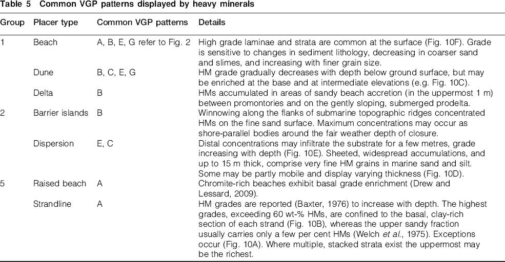
Only three placer groups are well represented to varying degrees of commercial importance (Table 5). Placers overtaken by a transgressive sea generally are reworked to destruction and do not remain as two groups of submerged placers. Strandlines and dunes are presently the source of most HM production. Nearshore deposits are increasingly important.
Common VGP patterns displayed by heavy minerals
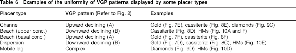
Some common placer types exhibit the same basic VGP patterns, regardless of the mineral involved (Table 6).
Examples of the uniformity of VGP patterns displayed by some placer types
Complex vertical grade profile
A common feature of many complex VGPs is the presence of three distinct mineral grade maxima (Fig. 11). Each maximum follows a unit resulting from the lag process (downward declining grade) and precedes an accumulation unit (upward declining). The author has observed similar, triple grade maxima in major onshore placer deposits worldwide. They include the gold placers of Yuba, California, which for many years were not drilled fully to bedrock. In deeper areas only the uppermost maxima was sampled. Many placers, likewise, historically have not been drilled to the depth necessary to ensure that all the mineralised units in a potential pay section have been sampled. Too often drilling depth has been limited to the excavational reach of the available mining equipment.
Complex VGPs displaying three stages of grade decline or grade maxima. a exploited, deltaic tin placer, Labohan Degong, Selangor State, West Malaysia, showing three stages of upward grade decline (units 1, 3 and 5) with each followed by more rapid decline (units 2, 4 and 6), during an overall rise in sea level. Based on results of widespread drilling; b tin placer in the coastal area of Ringarooma Bay, Tas. An interpretation based on cross-sections (Anon., 1995); c HM mineralisation in the Rivière Natashquan delta, northern bank of the St Lawrence River, Canada. Based on drilling results (Potvin, pers. comm., 1993). Confidentiality prevents disclosure of the HM grades
Application of vertical grade profiles
Few placers comprise a single unit throughout their lateral extent. Outliers can be an exception. The preparation of VGPs reveals whether or not more than one unit comprises the pay section. Cross-sections showing the VGP at each sample site should be prepared, following the example of Abzalov et al. (2011). If more than one unit exists an iso-thickness plan and semi-variogram should be constructed for each. Kriging should not be applied to the entire pay section if it comprises two or more very different units. The volume and average grade should be estimated separately for individual units within the pay section.
Sampling problems can be encountered in some environments. Grades and thicknesses of lag gravels, for example, may vary considerably over 1 or 2 m laterally, resulting in a nugget effect (Saravanakumar et al., 2014). In contrast, an underlying accumulation unit may possess much greater, lateral grade uniformity. A compromise, always influenced by cost, is then required between two different, ideal sample spacings. Diamond exploration possesses its own unique challenges. Different average grain sizes may also suggest that sample support might be tailored for the unit containing the coarser grains and/or lowest grade. Other characteristics such as clay content and sediment particle size frequency distribution determine sampling practice and affect metallurgical recovery. These parameters vary from one unit to another.
Confidence in an interpreted VGP can be improved by plotting the corresponding chart of a more abundant accessory mineral. Coincidence of grade maxima elevations and grade decline directions may validate the VGP of the target mineral (Fig. 12). The accessory mineral can then serve as a proxy in reconnaissance exploration. For example, magnetite and ilmenite may act as proxies for each other or for chromite (Fig. 12A). The VGP of imitating HMs or fine gold may provide supporting evidence of uncertain diamond concentrations. Black sands and magnetite are useful proxies for some gold placers. However, outside certain grain size ranges, the grades of proxy and target minerals may vary inversely. Varying grain size and thus hydraulic equivalence, can give misleading results (Fig. 12B). Changing mineral supplies or energy levels may yield conflicting data (Fig. 12C).
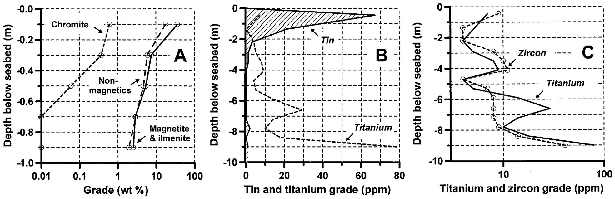
VGPs illustrating similar and dissimilar direction and rate of decline of co-existing minerals. a magnetite, ilmenite and non-magnetics imitating the downward grade decline, but failing to imitate the more rapid rate of decline, of chromite in an Indian beach placer. Based on published data (Gujar et al., 2010); b total absence of any sympathetic relationship between tin and titanium, Ringarooma Bay Australia. Modified from Davies (2009); c zircon imitating two of three titanium grade maxima, Ringarooma Bay, Australia. Modified from Davies (2009)
Placers should be sampled with an appropriate vertical interval which is equal to, or less than, the vertical selectivity of the intended mining tool. Otherwise, mine planning cannot prevent unwanted and unquantifiable vertical dilution or resource loss during mining. Operational flexibility is absent if changing economics dictate that a new cut-off grade is required. However, there is little evidence that the VGP is awarded the importance it deserves in evaluation, resource estimation and mine planning of some placers. Very few published technical reports authored by Qualified Persons provide more than a single grade for the full vertical extent of the pay section at a sample site. Meanwhile, interest is increasing in the exploitation of placers in the nearshore and offshore zones (Garnett, 2011). Plotting and interpretation of VGPs deserve to become a standard procedure in all stages from exploration, through resource estimation, to mining planning.
Conclusions
The pattern displayed by the VGP of a placer reveals the number of discrete units comprising the pay section. It shows the extent to which alternating processes of predominantly accumulation (upward grade decline) and lag concentration (downward grade decline) contributed to the development of a deposit. Reversals in decline direction represent scour horizons or stillstands. The history of a placer is fully displayed unless the pattern is modified or partly erased by reworking. A log10 line chart aids in interpretation. Parallelism of some lines on such a chart is common but does not indicate equal rates of grade change.
The pattern of a VGP may depend on whether the total mineral content, or only a particular size fraction, is reported. The mineral grain size may display a direct or inverse relationship with sediment particle size. Similarly, the relationship between mineral grade and grain size may be both direct and inverse within different units of the same placer. Sudden grade changes may coincide in elevation with lithologic boundaries. A suite of heavy minerals of different density and range of grain size invariably exhibit very different directions and rates of decline. Certain VGP patterns characterise specific placer types regardless of the mineral involved.
Preparation of the VGPs of a placer, preferably at an early stage in exploration, reveals the number of units comprising the pay section and any overburden. Few placers comprise a single unit throughout their lateral extent. For resource estimation they should not be treated mathematically on the basis of such an assumption. The preparation of a semi-variogram for each unit will guide the approach to using geostatistical techniques. It will also indicate the extent to which sample spacing may require a compromise between the demands of separate stacked units. Ideally, the vertical sampling interval should not exceed the intended mining selectivity, especially if the grades are marginally economic.
Economic interest is increasing in the exploitation of placers in the nearshore and offshore zones. Plotting and interpretation of the VGPs presently appears to be neglected. It deserves to become a standard procedure in all stages from exploration.
Footnotes
Acknowledgements
The author has drawn from his operational experience on placer exploration and mining programmes, mostly for tin, gold and diamonds. His intermittent association with placers resulted from his employment by Associated Mines (Malaya) Ltd, ConZinc RioTinto Sdn Bhd, Charter Consolidated Ltd, Anglo American Corporation of South Africa Ltd, and Hudson Bay Mining and Smelting Co, Ltd. His later roles as a director of Diamond Fields Resources Ltd, Diamond Fields International Ltd, and Minera Tierras Australes, plus retention as a consultant by several corporate clients, allowed additional involvement with placers in the marine environment. He gratefully acknowledges the extent to which all the companies have allowed him to expand his practical knowledge of placers. The text has benefitted enormously from the advice of referees.