
Abstract
Placers deposits are now known from five sedimentary environments; washout, river, aeolian, beach, and continental shelf. In each environment, the concentration of mineral grains, or sorting, takes place either by removal of gangue grains (denudation) or by addition of valuable grains (accumulation). Any given deposit will result from both processes but one will usually predominate. Denudation placers all sit on or just above erosive scour surfaces. They arise from a two-step process; initial particle deposition followed by selective removal of gangue particles. For example, deposits from a waning flood-stage river will include many different size, shape and density particles but a subsequent lower energy normal river flow might remove only the smaller, flatter or the less dense particles. The second fluid flow can be quite different from the first as, for example, when the wind selectively removes sand grains deposited by waves. Repeating these two steps, transportation from source and selective entrainment of grains results in a high placer mineral flux allowing denudation placers to achieve high concentrations of particular minerals. Denudation placers have a small thicknesses or vertical dimension, and so they are essentially condensed sections. To be economic, they must have a high value mineral, a large surface area, a long linear dimension, or exceptional grade, and preferably several of these features. Accumulation placer formation does not involve later partial rework and selective grain removal. Concentration grade depends on maximum availability of a valuable mineral and minimal availability of gangue grains capable of being carried with, and deposited from, a given fluid flow condition. Such placer deposits tend to be lower grade compared to denudation placers because the placer mineral flux does not focus on a single two-dimensional surface. Instead repeated favourable flow energy episodes superimpose placer grain enriched-sediment in situations of accumulation with minimal scour. Their large volume makes them economically valuable.
Introduction
Placers are detrital sediment deposits. They contain economically extractable concentrations of valuable minerals with a specific gravity or density greater than quartz (2·65 g cm−3). Most theories of placer formation have been developed by people working on alluvial gold but this is only one of the viewpoints presented here.
Density and the chemical and mechanical durability of resistate grains are the principal properties that facilitate sorting in the creation of placer deposits, but grain size, and grain shape also play critical roles (Youngson and Craw, 1999) and surface wettability and magnetism also contribute. ‘The list of minerals which can be concentrated in placers contains approximately 40 species, including 30 minerals that can make up individual deposits’ (Patyk–Kara, 2002). Nephrite (greenstone, or the actinolitic form of jade) for instance, is a placer mineral occurring in the glacial outwash alluvial sediments of the west coast of the South Island of New Zealand. It is durable, has a density between 3 and 3·5 g cm−3 and has some commercial value. The mineral has been recovered from river sediments and sold, but, unusually for a placer, it has most value when it is in the form of boulders.
Placer deposit classification
Recognising some important differences between placers helps not only for understanding their genesis but also to predict their location and properties during exploration. When considering a placer exploration programme, the most useful target distinction is whether the source proximity or the sorting factor dominates in concentrating the relevant mineral. Intuitively we seek zircon in beach placers, because most zircon occurs in durable sand size grains easily dispersed over hundreds of kilometres, and concentrating only where sorting processes allow. In contrast, because of both size and density, gold nuggets and nephrite boulders show preference for sites close to their provenance. Soft, good cleavage minerals of lesser durability, such as monazite prefer sites closer to their provenance as well, and cannot sustain extensive sediment recycling.
The proximity to source and the sorting both affect all placers, but not equally. For instance, even in deposits dominated by sorting such as beach sites, higher grade deposits will tend to occur closer to source where dispersal is less. In all environments, the background concentration, or mineral availability, is a key factor in placer exploration; even the most effective processes cannot generate economic deposits where mineral contents are too low, i.e. too far from the source and too dispersed.
Geologic environment makes up a third factor to consider in any placer mineral search. Some fluid flow regimes occur in only one environment, effectively isolating certain placer types to that environment. Fluid flow regimes peculiar to specific environments include oscillatory wave action on a beach, or on the seafloor, and single direction, but varying velocity turbulent or laminar flow in a river. Water-charged high density flows are confined to specific environments.
Deposit volume is a factor of economic concern in some placer exploration sites, because low economic mineral value necessitates large scale accumulation in sediments at tens of metre to hundreds of metre thickness, whereas a high mineral value permits mining in essentially two-dimensional denudation environments where deposits have only decimetre to metre scale sediment thicknesses. Diamonds were once sought on wind deflation surfaces in what is now Namibia (Cornell, 1920). In contrast, magnetite is mined from huge dunes at Taharoa and Waikato North Head, New Zealand (Mauk et al., 2006).
It was Kartasov (1971) who first noted the provenance versus sorting, and accumulation versus degradation factors in river placer settings of gold. His autochthonous placers arise at the base of river channels, can occur with any intensity of flow and consist of coarser gold trapped in channel floor roughness, and not transported far from source. In contrast, Kartasov's allochthonous gold placers form from finer grained gold as much as 25 km from source and depend on deposition from particular flow regimes depositing limited gold grain shapes and sizes, and these form during river aggradation.
The fundamental distinction between the two placer types is not distance from source, as implied by the names Kartasov chose, but the process of formation; in one case denudation (i.e. scour, erosion) and in the other, accumulation. Observing reworked black-sand concentrations at the foot of erosive mini-scarps cut into the beach profile or wave-cut dunes, Stanaway (1992) saw that autochthonous placers were erosive lags from prior accumulative black-sand enrichments. These accumulations resulted from a process that reworked an earlier deposit. In terms of exploration modelling, knowledge of the immediate process of formation and source site is more useful than knowledge that the minerals were derived from a certain rock hundreds of kilometres away. Distance from ultimate source rock is thus not the prime discriminant for the two placer processes, and hence the current scheme does not perpetuate the names of Kartasov (1971). Because autochthonous placers are distinguished by erosive scour at their base rather than distance from the source, the term denudation is preferred in this paper while accumulation is preferred for allochthonous placers. These two fundamental placer-forming processes have also been described by Garnett and Bassett (2005) using the essentially synonymous terms lag and accumulation but in this paper the presence of a scour surface is emphasised because this is feature that can be readily observed in the field.
There are examples of denudational placers where the relevant minerals have been transported to their present location in quite different fluid flow regimes from those that were responsible for reworking and concentrating the mineral. Aeolian placers are one such example; another example would be placers derived from glacial debris followed by river or beach reworking.
Mathematical analysis of mineral grain interactions in water have led to equations and concepts applicable to denudational placers (Slingerland and Smith, 1986). They describe several mechanisms of failure to entrain that include trapping where denser grains in a traction load test the bottom more often and thus more often fail to entrain. Other failures to entrain include: overpassing or winnowing where the smallest, largest and densest particles lag; armouring, where smaller grains are winnowed; and hiding, where smaller size and greater density act to resist further motion effectively ‘hiding’ grains in bed roughness (Table 1).
A placer deposit classification
In the description of the ten placer deposit models and five sedimentary environments that follow, it is important to recognise that multiple models and environments can occur in one sedimentary sequence or basin.
Aeolian placers
Deflation placers
These form when a strong unidirectional wind removes sand, silt and other fine non-cohesive material, leaving larger grains such as pebbles and dense grains like gemstones, on an indurated, pebbled, rough or wet surface. Minerals that have failed to entrain, because of size, density or shape, accumulate as lag on the eroding surface. This placer mechanism may contribute in a minor way to the formation of heavy mineral beach placers should a strong onshore wind entrain dry quartz grains. Pebbles subjected to prolonged sand blast on exposed surfaces may become faceted. The diamond grains reportedly seen and collected early in the twentieth century on the surface along parts of the Skeleton Coast of Namibia may have been concentrated by such a mechanism from original pebbly sand beach or river concentrations (Cornell, 1920; Garnett and Bassett, 2005).
Deflation placers are denudation features that arise in two steps. The first is sediment deposition by an older flow regime such as a river or beach, followed by failure to entrain by a new fluid flow regime which in this case is the wind. Deflation placer grains may ultimately come from hundreds of kilometres away, but source for the placer creation is proximate.
Dune placers
Coastal dunes are storage and preservation sites for concentrations created on beaches. These kinds of storage have built up where prevailing onshore winds blowing sand off beaches have piled dunes against water or land barriers, such as lagoons, swamps, steep hillsides or fault scarps; thus preventing dispersal of the grains. Vegetation in warm humid climates can also bind dunes and prevent their reworking. Coastal dune placers always form within 5 km of the site of beach concentration. Without barriers to their migration, the wind would have dispersed sand inland to form a sand plain with numerous small dunes as the author has observed on the Foxton Flats north of Wellington, New Zealand, in west Senegal, and inland of the Orangeburg scarp in South Carolina, USA.
Examples of economic dune placers are the Waikato North Head and Taharoa titano-magnetite sands of the North Island of New Zealand. These are the largest and highest grade terrestrial placers on the planet today in terms of tonnage of valuable mineral content. At Waikato, resources and reserves currently stand at 900 million tonnes of sand grading 22% magnetic minerals (Barakat and Drain, 2006). At Taharoa, resources and reserves reach almost 400 million tonnes at 45 to 50% magnetic minerals (Barakat and Ruddock, 2006). The deposits have Pleistocene and Holocene sands draping over them (Mauk et al., 2006) and have formed from sand blown two to three kilometre inland from beach concentrations by the dominant south-westerly winds. Longshore drift has swept beach magnetite concentrations along shores with coastal cliffs preventing inland dispersal until they reached coastal indentation traps caused by river erosion or block faulting.
Other examples of dunal storage placers are the one to four kilometre wide dunes along the east coast of Africa from east of the Cape of Good Hope to Somalia (Stanaway, 2005). Dunes along the east African coast extend only a few kilometres inland from the shore, except east of the Limpopo where five sets of one to four kilometre wide dune systems are parallel to the coast and represent former sea stands on a coastal plain.
Washout placers
Colluvial and eluvial placers
These classic placers form near sites of chemical and mechanical weathering and washout of weathering-resistant constituents from rock. Enclosing host minerals are hydrolysed and wash downslope as solutes, hydrolysate clays, oxides and talus. Once liberated, the higher density resistate minerals concentrate in the talus on sloping surfaces, and as smaller grains hiding in lag deposits. Colluvial placers form on scoured and erosional hill-slopes, and belong to the denudation class with strong provenance control. Downslope they grade into sheetwash and alluvial placers.
The layered harzburgite massifs of New Caledonia are associated with an example of this placer type. Colluvial placers form on steep hillsides from dunite layers with 50% or more chromite (podiform chromitites). Meteoric water driven by gravity on hill-slopes, removes lateritic cap-rock, weathered rock, clays, and colloidal hydrolysate iron-manganese oxides. Chromite is more resistant to hydrolysis than are the source rock minerals of olivine, pyroxene, amphibole and plagioclase, and so the chromite accumulates by lag on the steep drainage slopes.
Sheetwash and debris flow placers
Sheetwash placers are sediment accumulations sourcing their valuable minerals from a nearby weathered rock. In vegetation-poor sites, high precipitation can cause flash flood, debris and mud flows that deposit poorly sorted sediment in drainage depressions. These processes can operate either on low gradient peneplain surfaces that have undergone deep chemical weathering, or on higher gradient alluvial fans. Factors that result in sheetwash placers include:
sufficient concentration of the mineral in a source rock
enough rock weathering to liberate the mineral
preferential entrainment of hydrolysate clays and silt fines in the suspended load of the stream flood or debris flow
lag of larger clasts at the point of provenance.
Desert margin climates with alternating humidity when weathering takes place under forest cover, followed by arid un-vegetated conditions when sheetwash and intermittent stream flows occur are a favourable environment for this class of placer. Several placer accumulations of gold, silver and cassiterite in the Andes are sheetwash-related (Garnett and Bassett, 2005). Initially, the flow leaves coarse clasts behind, then selectively entrains sand with mud, and finally preferentially de-trains sands leaving the mud to flow away (this all occurs as one operation).
Excellent examples of sheetwash placers on a weathered peneplain are the rutile placers near Gbangbama in Sierra Leone (Stanaway, 1992). Here, 250 million tonnes of sediment contains 3·5 million tonnes of rutile at grades of 1 to 2%; this forms in six shallow drainage depressions averaging 8 m deep. No part of any deposit appears more than 6 km from the source rock of weathered charnockite which has 0·5 to 1% rutile. The placers consist almost entirely of poorly sorted silty and clayey sand with only a few quartz pebbles, rare thin lateritic sieve gravel layers and scattered plastic clay beds.
River placers
River denudation placers
Denudation placers lie on scour surfaces. In upstream gullies or gulches, bedrock forms the scour surface and gives rise to gulch placers and bedrock placers, referred to also as bottom placers if covered by alluvium. Downstream in aggrading alluvium, lag gravel, granules coarse sand, and high density minerals such as ilmenite and magnetite delineate the scours, and these may be only a single layer thick. These mafic minerals are visible at the margins of sets of current-beds, especially near the basal margin. Such scour can form extensive surfaces within thick sequences of alluvial valley fill. Modern academic studies tend to use flumes and rivers and focus on flow regimes but miss the vital exploration target relation between denudational placer deposits and scour surfaces.
Mining of Miocene-aged gravels of the lower Orange River in southern Africa has revealed excellent examples of diamond concentration in irregular bedrock scour surface potholes and ridges by fluctuating energetic turbulent river flow. Significantly, the high diamond gravels display an unusual type of gravel packing that can only have arisen slowly in the turbulent flow where the earlier grains act as a sieve that traps or hides successively finer grains (Jacob et al., 1999). The lengthy gravel flux required for this packing has also allowed a larger flux of diamonds to become similarly trapped in the sieve structure and potholes.
The major concentration of gold in most river gravels and sands occurs on or within three metres of the major scour surface, i.e. near bedrock. For example, Peterson et al. (1968) describing the placer gold in the Tertiary river channels of northern Nevada County, California wrote: ‘The drilling records indicate that the highest gold concentration is near the bottom of the deepest part of the channel’. Similarly, Yeend and Shawe (1989) writing of the Fairbanks District of Alaska stated: ‘The bulk of the placer gold came from gravel from just above to nearly 3 m above bedrock’. Gold miners refer to river denudation placers as bottom placers if they lie on river channel bedrock and, as above–bottom placers if they lie within alluvial valley sediment. The greater richness of bedrock placers relates to the frequency of erosion extending down to bedrock after periods of alluvial accumulation. Typically, above-bedrock placers record only one such down-cutting (Kartasov, 1971).
River denudation placers form as the placer minerals from earlier fluid flow conditions fail to entrain during later scouring. River denudation placers are condensed sediments that capture mineral grains from a large mineral throughput or flux; the valuable minerals fail to entrain in later fluid flows. These deposits tend to be closer to source than river accumulation placers.
River accumulation placers
Accumulation placers are created when high specific gravity and hydraulic-equivalent sand-sized grains are transported only within that part of water flow with the energy and other factors best suited to carrying them. If a river channel is deep enough and if discrete and differing flow regimes both persist and vary with depth they will deposit vertically stacked facies defined by grain-size as gravel, sand, or clay beds. Flow regimes can produce concentrations based on specific gravity (Burton and Fralick, 2003). These natural river flow sorting mechanisms have counterparts in the technologies used to recover ilmenite and zircon sands; e.g. in the spiral separator when different velocity flows across the spiral channel separate and isolate more- and less-dense grains in two distinct flows, flowing beside each other, with the high density minerals favouring the inside and the lower density on the outside of the spiral channel. The pinched sluice and cone separator operate similarly to spit two flow regimes and their differing cargoes, but in a vertical dimension.
The existence of fine grained, flakey gold is well recorded and known as river bar placers (Dingman, 1932). The first person to record that finer grained gold grains had concentrated in accumulative point bars, rather than in the stream channel bedload lag and bedrock scour, was the Russian placer geologist Bilibin in 1938 (Kartasov, 1971).
The author has channel sampled a point bar, revealing 7% grades of ilmenite, rutile, zircon in fine-grained well-sorted sands in the wall of a flood chute on a Congaree River point bar, near Columbia, South Carolina. The regional background grade was 0·6%. In the Hinuera Formation river sands near Hamilton, New Zealand, he has observed fining upward sequences that show well-defined black higher density minerals concentrating in fine well-sorted sands toward the top of the fining sequences rather than in coarse sands or pebbles at the basal channel scour.
In brief, river accumulation placers deposit from fluid flow conditions where certain mineral grains are selectively entrained, transported and deposited. Flume experiments using Rio Grande river sands containing 0·38% magnetite (median diameter 144 μm) show that magnetite concentrates from transition and upper flow regimes in sands characterised by washed out current bedding and horizontal lamination (Brady and Jobson, 1973).
Drilling of hundreds of holes in the Cohansey Formation alluvials of the Neogene of New Jersey in USA has revealed several heavy mineral deposits aggregating more than 700 million tonnes of sand grading 3 to 5% heavy minerals (predominantly ilmenite and zircon). Holes near Upton show seven fining-upward sequences with high heavy mineral concentrations in the tops of four of them, and they can be correlated from hole to hole (Fig. 1). Erosion accompanying the deposition of the overlying sequence has removed the top of parts of the river accumulation placer in some drill holes. In these holes, high heavy mineral values have obviously persisted into the above-scour basal gravels of the overlying layer as a river denudation placer. Importantly, these placers could not have been beach deposits as proposed by Carter (1978) and Puffer and Cousmiler (1982). It remains axiomatic in the literature that high density mineral-enriched, horizontally laminated sands are ipso-facto beaches. Evidence for a beach origin reported by Puffer and Cousmiler in the Glidden Durkee deposit consisted of two thin storm-incursion clay layers with dinoflagellates within a 1·3 m thick peat horizon where 63% of the taxa found were fresh water types (Carter, 1978). The seven known ilmenite placer deposits all elongate perpendicularly or at high angle to any likely coastline suggesting rivers (Fig. 1). They slope as rivers do along the axis of deposit elongation at gradients of 1–2 m in 300 m (0·3o) and span elevations from 45 m above to 10 m below sea level. In addition, holes drilled by the author (60 plus holes in the Tabernacle–Fort Dix area, USA) sit in 1·5 to 4 km wide valleys cut into emergent marine Miocene grey-black Kirkwood Formation weathered to purple, mauve and red colours. Even Carter wrote that he was mystified by the current bedding in his Cohansey back barrier sands in quarries all over New Jersey consistently showing SE dips. If these were from a tidal environment, they should have displayed two opposing tidal directions.
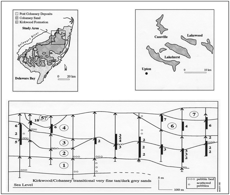
River accumulation placers (Top left) location New Jersey, USA (Top right) Orientation of placers showing orientation in ancestral river valleys prior to south-westward river capture by the present Delaware River (from Markewicz, 1969). (Bottom) E–W drill cross-section SE of Upton. Vertical arrows show holes and direction of fining with scour surface gravel grit or coarse sand at base. Fining units are numbered in circles. Accumulation placers are shown with thicker lines in fine sands toward the top. Numbers show heavy mineral grades, with background at 0·65% heavy minerals. Topmost silts and clays are generally missing due to erosion accompanying overlay of next unit. Note the river denudation placer above the scour base of units 3, 4 and 5 with mineral eroded from accumulation river placer beneath
The relation between denudational and accumulation placers in river sediments
Channels as deep as 10 m in high sinuosity meandering rivers (Fig. 1) provide a clear vertical separation for denudational (at the base) and accumulation placers (near the top). These streams carry low thin bed loads, accrete laterally and form classic point bars. However, increasing the coarser sand and gravel bed-load component of the stream demands a faster flow and increased gradient resulting in a shallower channel and less sinuosity. Vertical separation between scour and accretion diminishes. Further increasing the bed-load results in braid or longitudinal bars developing in the river channel, and the choked channel ultimately becomes a network of braided shallow channels where both scour and accumulation become entwined at nearly the same level. These high-bed-load braided streams feature in upstream drainages, alluvial fans and choke point discharge. Going downstream as gravel is lost, sand deposition increasingly occurs in fining upward facies leading to vertical segregation of accumulation placers in sands of hydraulically equivalent grain-size to the placer grain-size and shape available.
River placer summary
All river denudation placers form in a two-step process. In the case of upstream gulch placers the valuable minerals weather from both nearby rock at source and fragments of source rock broken off and travel downstream. After initial deposition the valuable minerals become trapped and concentrated in scour surface roughness, whereas the rest of the material with which they were initially deposited is borne away.
In contrast, river accumulation placers result from grain deposition without subsequent entrainment or removal. They are the present resting places for material that may have travelled tens to hundreds of kilometres. Accumulation placers tend to have lower grades because they lack the large mineral flux from iterative reworking that concentrates and condenses river denudation placers. The grade of the accumulation placers depends on the availability of gangue and placer mineral for transportation and deposition under the prevailing fluid flow conditions.
Beach placers
Transgressional beach placers (denudational)
Waves concentrate the higher density sand grains by selective deposition from advancing waves plus selective entrainment of lower density gangue grains into retreating waves. In situations where the sea has transgressed the easily-eroded sediments of the coastal plain, the waves erode at the shore-face and remove drowned terrain to wave-base. This is typically 10 m deep at a distance of 1 km offshore, and results in a planar sea-floor surface offshore and long curvilinear wave-dominant coastlines. Transgressional beach placers are all landward of and within metres of the trangressional scour wave cut surface (Fig. 2). They are denudational, and they derive their mineral from either proximal sources such as the shoreface and cliffs, or from distal sources via rivers and longshore drift.
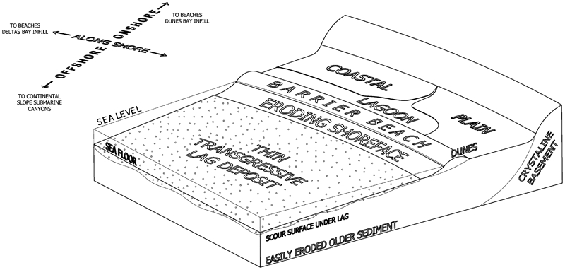
Marine transgression onto a tectonically stable, low gradient, sand and mud dominant, coastal plain showing how erosion of the shoreface yields a wave-dominant shoreline. There is a transgressive barrier beach and dune together with a thin transgressive lag deposit carpeting the new offshore wave-cut surface. Arrows show direction of sediment movement from the shoreface. On higher gradient coastal plains, cliffs will form behind the beach. Breaker bars, tidal inlets, ebb and flow tidal deltas as well as incompletely eroded former beach complexes occasionally present as shoreface ridges (Plint, 2010); these have been omitted for purposes of illustration
The highest grade strand placers (all highly susceptible to erosion) lie on shorelines of ultimate transgression on passive margin continental coastal plains. Transgressional strand placer deposit thickness depends primarily on tidal range. An example of denudation beach placers on an ultimate shoreline are the iron-sand strands on the passive margin west coast of the North Island, New Zealand.
Like the previously described aeolian, washout and river placers these transgressive beach placers have derived their mineral value from a two-step process: an initial emplacement of the mineral on a beach followed by the rework of that beach as the sea continued eroding landward, a process repeated over and over again to give a high mineral flux and ultimately a very consistent heavy mineral assemblage along the strand.
Regressional beach placers (accumulational)
Aerial photos of coastal bay infill and wave-dominant cuspate deltas can show fan shaped sub-parallel sets of ridge and swale structures called beach ridges roughly aligned in accord with the coast. These beach ridge plains consist of accreting beach berms often many kilometres long, 50–150 m apart and 1–3 m high. They show how the shoreline has regressed and the sea retreated with the addition of sand. This sand can originate from rivers, when such a feature is called a cuspate delta, but the sand can also derive from the seafloor as sand swept forward by waves, from longshore drift and from biogenic debris (shell hash). Plint (2010) describes how the asymmetry of breaking shoaling waves moving up the shoreface pushes the coarser (and by implication the denser) mineral sand grains forward up the shoreface to give coarsening upward sand.
Because beach ridge plains are accumulating systems not undergoing marine transgressive erosion, the beaches are not repeatedly undergoing scour and entrainment of earlier beach concentrations. Achieving economic grades often requires additional processes. One such process is a temporary marine transgression. Such an event can give rise to the Type A mineral sand deposits described from the east coast of Australia by Roy (1999). These appear on aerial photos as unconformities or discontinuities cutting the linear ridge sets. Type B economic placer deposits appear at the rear portion of a strand plain and are obviously the sites of ultimate transgression prior to the commencement of regression. Roy's beach placer Type C form following temporary wave and current access to placer concentrations in the sands of tidal deltas, offshore ridges and along-shore transgessive beach placers.
The presently mined SE Madagascar ilmenite-zircon sand placers at Madena, Petricky and Ste. Luce are regressional beach environments (Dumouchel et al., 2005) and belong to the Type C regressional placer class because the adjacent land possesses weathered valuable mineral rich metamorphic source rock capable of supplying the ilmenite and zircon with minimal dilution by quartz and other gangue.
Accumulative regressional beach placers include the Green Cove Springs series of deposits in Florida USA. The deposit system there is about 30 km long by 7 km wide and from 1·5 to 14 m thick. About 210 million tonnes of sand have yielded 7·25 m tonnes of ilmenite, rutile and zircon at a grade around 3% (Rose, 2005).
To achieve economic value via a single depositional event, an accumulation regressive beach placer requires a richer source material than does a denudational transgressive beach placer. The Type A and B placers described above represent transgressive rework zones within a sequence of overall accumulation. Type C deposits are true accumulation placers.
Continental shelf placers
Transgressive lag placers
Transgressive lag placers are denudational, and form in easily eroded intra-cratonic basins and on continental passive margins with negligible new sediment supply. During marine transgression, material eroded off the shore-face undergoes removal in three basic directions; onto the land, along the coast, and offshore. Scattered pebbles, shell hash, and higher density minerals together with sand that fails to entrain in the removing currents leave a less than metre thick, sediment layer on the seafloor. Such condensed strata can cover hundreds of square kilometres. They are commercially viable if they host high value gemstones and if exploration reveals potholes or traps with exponential grade increases. Negligible new sediment supply may allow thin mud which tends to cover the lags. These placers sit upon a scour surface or platform cut into the proximate source sediments below (Fig. 2).
A transgressive lag placer partly explored in the 1990s and formed during several Neogene marine transgressions, has been found off the west coast of South Africa. The low gradient seafloor 90 m deep 5 km offshore to 140 m deep 40 km offshore is underlain by Cretaceous and Tertiary delta sediments deposited by an ancestral Orange River that transported diamonds from Cretaceous kimberlite pipes on the Kaapvaal craton. Several erosive transgressions have flushed away the top 90 m or more of the delta sands and muds, concentrating rounded quartz pebbles, diamonds, shell hash and sand as a transgressive lag layer generally less than 1 metre thick. These sediments partly bury some gently westward dipping alternating harder and softer layer erosional remnant cuestas, as seen from side-scan sonar. The diamonds are very high quality because only the best have survived the long distance transport (>90% are gem quality). On land, Miocene Orange River gravels yield their best grades from potholes at 0·1 to 0·5 carats per ton (Jacob et al., 1999). Offshore, diamonds also show highest grades in potholes.
Subsiding shelf placers
Subsiding shelf placers occur in cratonic basins or passive continental margins and result from an abundant fine sediment supply via coastal and offshore marine erosion. Covering areas from square metres to tens of square kilometres with thicknesses from centimetres to tens of metres, they form in belts 5 to 20 km offshore with individual placers reaching dimensions tens of kilometres long and up to 10 km wide (Fig. 3). These offer potential for mineral sand tonnages even larger than those in dunes. They comprise very well sorted fine and very fine sand. Placer minerals include ilmenite, zircon, rutile kyanite, sillimanite and gold (Patyk–Kara et al., 1999). All the minerals have smaller grain-sizes than the quartz gangue at 50 to 120 μm. Subsiding shelf placers appear to form at depths below fair-weather wave base and above storm wave base in the near-shore shelf zone where stronger storm-induced waves stir bottom sediments. A feature of one of these deposits (WIM150 in Victoria, Australia) is hummocky cross stratification (Williams, 1990) also recorded by the author in another of these deposits in the Cretaceous McNairy Formation sands of Tennessee, USA. Descriptions of structures in fine sand facies of similar deposits on the Russian Platform strongly suggest hummocky cross stratification (Savko et al., 2000). These placers of offshore origin were first discovered in the 1960s in the Jurassic to Palaeogene fine sands of the Tethys Sea on the Russian Platform, but their mode of origin appears to be only recently recognised.
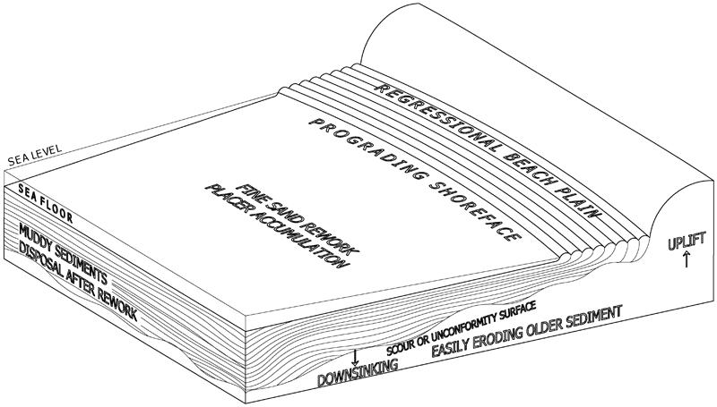
Marine regression depositing sand and mud-predominant sediment over a downward tilting continental shelf showing a zone of normal and storm wave base rework of offshore migrating fine sediment. The thickness of the lag accumulation depends on sediment supply, rate of down-sinking and storm rework frequency. Subsiding shelf placers are not confined to a scour or unconformity surface as is a transgressive lag
Subsiding shelf placers are initiated by storm-driven unidirectional currents coupled with wave derived oscillatory currents capable of reaching greater depths because of greater wave amplitudes and periods during storms. Deposit genesis starts with the formation of a storm surge when low air pressures and strong winds are blowing water onshore and piling up water. The returning bottom-hugging geostrophic flows can reach velocities of 0·7 m s−1 enabling them to move and sort sand (Plint, 2010). Each event unit that makes up a deposit, according to Plint, starts when waves from a rising storm scour into the muddy seafloor to suspend the fine sand and mud. As the storm wanes planar-laminated fine sand deposits first, this gives way to hummocky cross stratified fine sand which initially may be anisotropic, but as the unidirectional geostrophic flow component weakens this will become oscillatory eventually declining to two-dimensional ripples. Current velocities over 0·5 m s−1 give the flat bed condition favourable for higher density mineral concentration (Brady and Jobson, 1973). According to Plint (2010), each storm unit would be centimetres to decimetres thick with most of the deposition taking place with the initial flat bed and anisotropic hummocky bed structure. Such an accumulation would involve thousands of units just described and doubtless could reach tens of metres thick with 15 m the maximum recorded in the literature to date. The required sediment volume would be derived from gentle continuing down-warp, and sediment supply in excess of that needed to maintain the seafloor depth (Fig. 3). Enrichment of placer mineral can reach 10 to 100 times background values in surrounding fine sand sediments.
An example of such a deposit is WIM150 in the Murray Basin, Australia. Depending on the cut off chosen, this deposit has between 4900 m t of very fine sand grading 2·8% total heavy minerals (Williams, 1990) and 542 million tonnes grading 5·9% HM (Australian Zircon, Report, 2008). According to Williams (1990) it consists of hundreds of thousands of millimetres thick lamina and layers enriched in ilmenite, rutile and zircon, each persisting laterally for hundreds of metres. They aggregate 6 to 15 m thick and dip about 3 degrees NW. The WIM150 deposit is part of a series of placers in an arcuate band 150 km long and up to 25 km wide close to the southern edge of the Murray basin. These lie at the base of a coarsening upward Pliocene sand sequence.
The complex history of these subsiding shelf placers is demonstrated by the Tsentralnoye ilmenite, rutile zircon and gold placer in central Russia described by Patyk–Kara et al. (1999). This 15 km long by 5 km wide fine sand resource is from 1 to 15 m thick. It began to form in the late Cenomanian as an offshore delta front mineral sand accumulation as witnessed by glauconite, the macro and micro fauna and phosphate grain coatings (Savko et al., 2000), but became emergent as sand bars. By the Santonian, it had become fully emergent and a new top surface was established by the wind (Patyk–Kara et al., 1999) before final burial under muddy sediments. Mineral sand grades reach as high as 7% heavy minerals.
Exploration for subsiding shelf placers should focus on sedimentary basins and passive continental margins exhibiting transgression-regression sequences where shoreline and river sediments cover marine deposits. A related target situation is a slowly subsiding marine realm adjacent to a rising terrestrial sediment supply as is the case for the WIM150 deposit in relation to the Western Highlands axis uplift in Victoria, Australia (Wallace et al., 2005).
Conclusion
Economic placer concentrations have now been recognized in all the major sediment environments except submarine canyon, submarine fan and abyssal plain. The genetic classification proposed not only covers all known placer types, but allows future placer exploration to proceed using a broad and useful understanding of geological process. In the past, descriptive classifications have been the norm for placer exploration and these have led to prospecting by looking for deposit analogues, principally by sampling in similar geomorphological features rather than by understanding of formational process. This emphasis on analogues has probably not overly troubled explorers since prospecting has been successful, despite taking place empirically by sampling streams, rivers, beaches and dunes. Understanding new deposit types stumbled upon by chance, such as the transgressive lag and subsiding shelf placers has taken time and is as yet far from complete; the question remains are we blinded to future potential? Subsiding shelf placers may yet prove to be the largest of all placers in terms of tonnage of contained valuable mineral, but have only recently been discovered. The accumulation placer model is only an application of the principles of sediment sorting by grain-size to sediment sorting by grain density. One interesting feature of the subsiding shelf placer deposits of Russia is the occurrence of fine gold, probably in hydraulic equilibrium with the other placer and gangue particles. Could more gold be found in such environments? Do all subsiding shelf placers have to consist of fine sand? Could they also result in lag gravel accumulations with different valuable minerals?
Placer deposits are linked not only by the two-fold process proposed above, but also in nature. Many sand placer deposits occur along ancient shorelines as is evidenced by the Trail-Ridge-Orangeburg Scarp of the south eastern Coastal plain of the USA. In at least two sediment basins, subsiding shelf placers are known to occur stratigraphically beneath regressional beach placers, a possibility depicted in Fig. 3. This pairing occurs both in the Murray basin and in the Oligocene-Miocene of the Dneipr-Donetz basin of Russia (Patyk–Kara et al., 1999). It may even occur in the northern Florida Trail Ridge (fine-medium sand)-Green Cove Springs (very fine sand) mineral sand pairing, where the uplift required for a subsiding shelf placer would have been provided by the contemporary rising Ocala Arch. In this last case however the offshore placers were reworked into a regressional beach system to be mined as the Green Cove Springs sand placer.
Footnotes
Acknowledgements
The author thanks several anonymous reviewers for the care and effort they applied to correct and clarify his thinking and writing. He also thanks Rio Tinto Iron, Rio Tinto Iron and Titanium, BHP Minerals Exploration, Cluff Resources, Sierra Rutile Ltd, E. I. du Pont de Nemours and Company, JBL Exploration and Carpentaria Exploration for the opportunity to investigate many different placer deposits.