
Abstract
Pakistan is situated in one of the highest seismic zones of the world, with the 1935 Quetta earthquake and the 2005 Kashmir earthquake as the most devastating earthquakes in the country. Pakistan has also recently suffered from severe flood events, in 2010 to 2012. Recent experiences in the above-mentioned events emphasize the need for a multi-hazard approach to assess the vulnerability of typical building types in Pakistan. The multi-hazard map is classified into four hazard-dominated areas: earthquake-, flood-, combined-, and no hazard–dominated areas in Pakistan. The distribution of the typical building types of Pakistan is globalized in terms of few, many, and most ranges to make a regional map of Pakistan. This map shows seven regions all over Pakistan, indicating the groups with certain predominant building types in each region. A multi-hazard risk map of Pakistan is the final outcome of the study.
Introduction
Pakistan is divided into the following provinces—Punjab, Sindh, Balochistan, and Khyber Pakhtunkhwa (KPK)—and the following territories—the Islamabad capital territory, Gilgit-Baltistan, the Federally Administrated Tribal Area (FATA), and Azad Jammu Kashmir (AJK). These provinces are further divided into administrative units called districts (which are subdivided into tehsils).
Pakistan has suffered from some major natural hazards in the last decade, including the 2005 Kashmir earthquake, the 2010 flood, and the 2011 flood, which resulted in enormous damages to both property and human life.
For the first time in Pakistan, major efforts were initiated after the 2005 Kashmir earthquake, to evaluate the seismic vulnerability of existing building stock against earthquake. Several field surveys were conducted to define typical building types in Pakistan, and to observe damages/failure mechanisms of buildings caused by the 2005 Kashmir earthquake (Maqsood and Schwarz 2008a).
The European Macroseismic Scale 1998 (Grünthal et al. 1998) was used to define typical building types in Pakistan and their vulnerability, by taking into account local construction practices and material properties. Moreover, geostatistical extrapolation was carried out, using the statistical data from the 1998 national census conducted by the Government of Pakistan. Recent floods in 2010 and 2011 were the most devastating floods in the history of Pakistan, and they emphasize that although earthquakes are major hazards in Pakistan, considering one hazard at a time is not sufficient for the purposes of vulnerability calculations of the existing building stock. Hence, a multi-hazard approach is recommended in the current paper. Figure 1 elaborates the procedure used in current paper for developing risk maps of Pakistan.
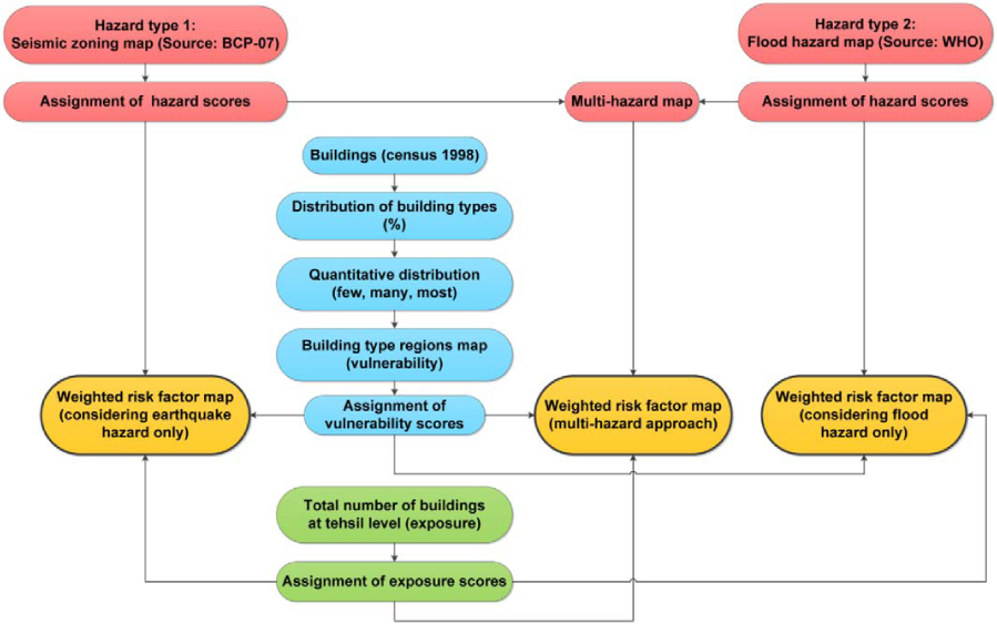
Flow chart for weighted risk factor maps of Pakistan.
Single-Hazard Zoning Maps of Pakistan
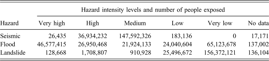
According to the World Health Organization (WHO; 2013), almost 20% of the population of Pakistan is exposed to high or very high intensity in the case of seismic hazard; almost 40% in the case of flood hazard and almost 1% in the case of landslide hazard (see Table 1). It shows that in Pakistan, seismic and flood hazards are dominant when compared to landslide hazard.
Total number of population exposed to hazards, by level of intensity (
Seismic Zoning Map of Pakistan
The seismic zoning map of Pakistan proposed by the Building Code of Pakistan (BCP; 2007) is shown in Figure 2. According to it, Pakistan is divided into five seismic zones (Zones 1, 2A, 2B, 3, and 4) considering the severity of seismic hazard; zone 1 is the lowest, and zone 4 is the highest seismic zone. It is evident from the seismic zoning map that the northern parts of Pakistan, as well as the north western parts of Balochistan, are situated in high seismic zones, whereas most of Punjab and Sindh provinces are situated in low seismic zones.
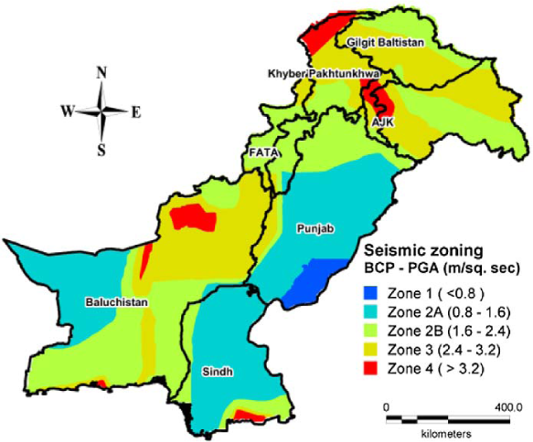
Seismic zoning map of Pakistan according to Building Code of Pakistan (BCP 2007).
Giardini et al. (1999) compiled the Global Seismic Hazard Map (GSHAP) as PGA, with a 10% probability of exceedance in 50 years (475-year return period). Figure 3 shows the seismic zoning map according to GSHAP; note that for Pakistan, the ranges of PGA in terms of zones, as well as colors, are slightly modified, in order to compare it with the seismic zoning map proposed by Building Code of Pakistan.
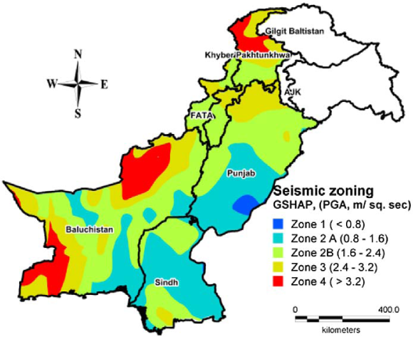
Seismic zoning map of Pakistan according to GSHAP (Giardini et al. 1999).
Maqsood and Schwarz (2010) has compared the GSHAP seismic zoning map with different zoning maps, including the seismic zoning map proposed by BCP (2007). The comparison shows that GSHAP, in general, predicts more PGA values in many regions of Pakistan, particularly in the southwestern region of Balochistan (the “Fa factor,” defining the level of difference between the two hazard assessment, in terms of PGA values, is more than 3). But, at the same time GSHAP predicts less PGA values as well in some regions of Pakistan, particularly in southern parts of Sindh and Balochistan provinces. Nevertheless, for the current paper, the seismic zoning map shown in Figure 2 is used, as it is the latest and official seismic zoning map proposed by BCP (2007).
Flood and Landslide Hazard Maps of Pakistan
Pakistan has suffered from floods in the past, but the recent floods in 2010 and 2011 were extremely destructive. According to the National Disaster Management Authority (NDMA; 2010), 78 out of 146 districts were flooded in the 2010 flood. Figure 4 shows a map with the major and minor rivers of Pakistan and the flood-affected districts in the 2010 flood. It is clear from the map that severely affected districts are located in the Khyber Pakhtunkhwa, Punjab, and Sindh Provinces. During the 2011 flood, almost the whole of Sindh Province was flooded (see Figure 5). The 2010 flood was triggered due to heavy monsoon rainfalls in different parts of Pakistan. The eastern rivers (Ravi, Chenab, and Jhelum) in Punjab Province were mainly unaffected in 2010 and 2011, but historically there have been huge floods in these rivers too (Majid and Akhtar 2007).
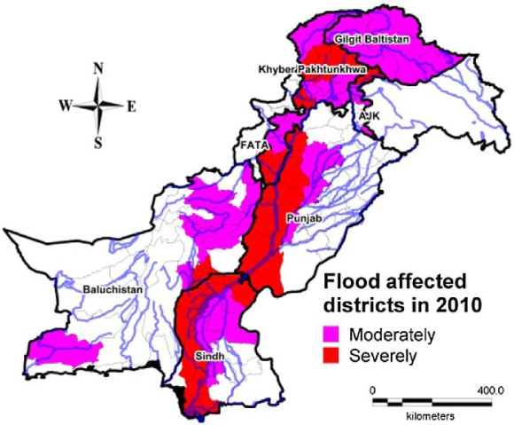
Flood affected districts in 2010 (Siddique and Schwarz 2012).
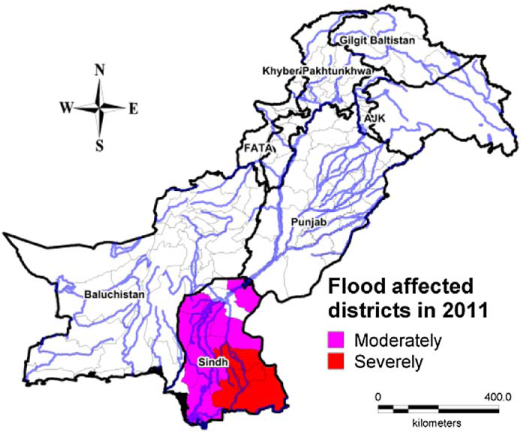
Flood affected districts in 2011 (Siddique and Schwarz 2012).
According to the methodology explained in WHO (2013), a flood hazard (index) map is obtained by using the following steps:
Selecting causal factors (such as land cover, DEM, geology, soil type) Classification of the number of past flood events Estimation of weighted scores for each causal factor Standardization of weighted scores Aggregation and classification of the resulting map to obtain spatial distribution of flood hazard, indicating five intensity levels (from very low to very high)
A landslide hazard (index) map is obtained by using the following steps:
Identification of causal factors Reclassification of slope map Except for slope, normalization of causal factors to obtain a continuous scale Weighting of the causal factors Creation of landslide susceptibility distribution maps Combination of the landslide susceptibility distribution map with the slope distribution map to obtain the landslide hazard distribution map
Figure 6 shows the flood hazard map (in terms of hazard index). This map is based on records of floods from 1985 to 2009, which was also considered as a measure of return period for a flood. The landslide hazard map (Figure 7) indicates that most of Pakistan is exposed to Low or Very Low risk of landslides. Only northern parts of KPK and Gilgit-Baltistan provinces are prone to High risk of landslide. Therefore, only seismic and flood hazards are considered for the multi-hazard approach (ignoring the landslide hazard).
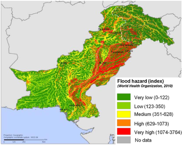
Flood hazard (index) map according to the WHO (2013).
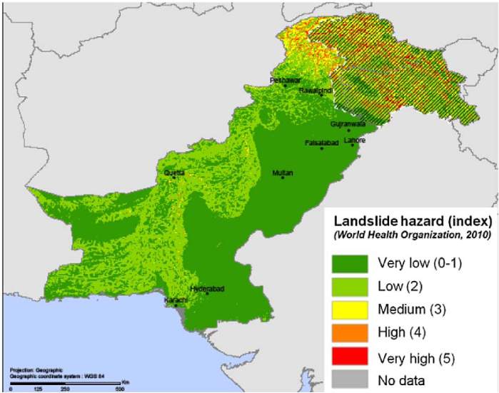
Landslide hazard (index) map according to the WHO (2013).
Multi Hazard Zoning Map of Pakistan
Multi-Hazard Zoning Map at the Tehsil Level
Based on the intensity level of earthquake and flood hazards, weighted scores are proposed here. For seismic hazard, scores of 1 to 5 are assigned, taking into consideration of increasing seismic hazard (increasing PGA values) from zone 1 to 4. For flood hazard, a weighted score of 1 is assigned to Very Low and Low hazard; 3 to Medium hazard and 5 to High and Very High hazard (see Table 5).
A multi-hazard map, at the tehsil level of Pakistan, is obtained by combining the scores of both hazards (see Figure 8). This map shows cumulative hazard in each tehsil. But it is not possible to differentiate which hazard is dominant in a particular tehsil. For example, a multi-hazard score of 7 is assigned to most of Punjab and the northern parts of Balochistan Province, without differentiating which hazard is dominant in both provinces (flood hazard is dominant in Punjab province, whereas combined hazard is dominant in the northern part of Balochistan province; see Figure 13).
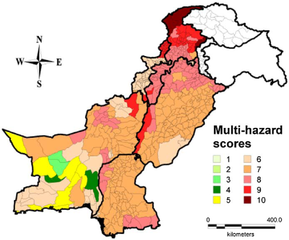
Map showing multi-hazard scores at the tehsil level, using BCP-07 seismic zoning map and flood hazard map by the WHO.
Figure 9 shows the map with multi-hazard scores, considering the GSHAP seismic zoning map. The comparison between Figures 8 and 9 reveals that in some regions GSHAP indicates a higher multi-hazard score, and at the same time, it shows a lesser multi-hazard score in some other regions of Pakistan. Therefore, it is decided in the current paper to use the national seismic zoning map (BCP 2007), as it is the most recent map. Nevertheless, the GSHAP seismic zoning map is also used for risk maps of Pakistan by Siddique (2015).
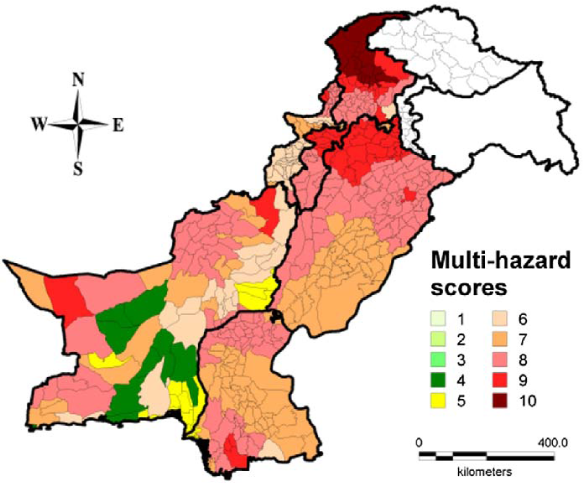
Map showing multi-hazard scores at the tehsil level, using GSHAP seismic zoning map and flood hazard map by the WHO.
Refinement in the Multi-Hazard Zoning Map
A refinement is necessary in the multi-hazard map shown in Figure 8 because that map does not represent the severity of a particular hazard. A flood hazard map, prepared by WHO (2013), indicates five intensity levels for flood. For simplicity, only three zones for flood are chosen: Low, Medium, and High. Figure 10 shows the flowchart of a multi-hazard zoning map. A correlation is developed between flood hazard zones and the information from the latest floods in 2010 and 2011. The districts that were severely affected by flood are categorized as zone 3 (High zone), the moderately affected districts are categorized as zone 2 (Medium zone), and similarly, the districts not affected by flood are categorized as zone 1 (Low zone; see Table 2).
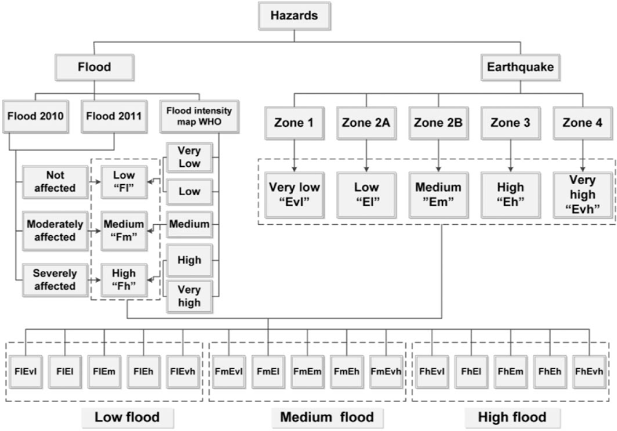
Flow chart of multi-hazard zoning map of Pakistan (Siddique and Schwarz 2012).
Multi-hazard zoning and classification scheme (
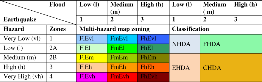
A combined flood hazard map is generated, merging the two-event-based flood hazard maps (i.e., the floods in 2010 and 2011) and a general flood hazard map from the WHO, keeping the maximum intensity of hazard from two approaches at the district level (see Figure 11). Five zones of earthquake hazard are combined with three zones of flood hazard. This leads to a multi-hazard zoning map of 15 possible zones (see Figure 12). Table 2 shows the legend and color scheme of the multi-hazard zoning map. Two types of hazards are defined, namely, “flood” (F) and “earthquake” (E), along with three intensity levels for floods: Low, Medium, and High (abbreviated as l, m, and h, respectively) and five intensity levels for earthquakes: Very Low, Low, Medium, High, and Very High (abbreviated as vl, l, m, h, and vh). To create a multi-hazard zoning map (shown in Fig 12), a raster with a grid spacing of 10 km is selected. Each grid element is assigned the appropriate multi-hazard zone. There are small inaccuracies in defining the boundaries of the districts and the boundaries of different seismic zones, because a square mesh of 10 km is used. The inaccuracies can be diminished by selecting a smaller grid size.
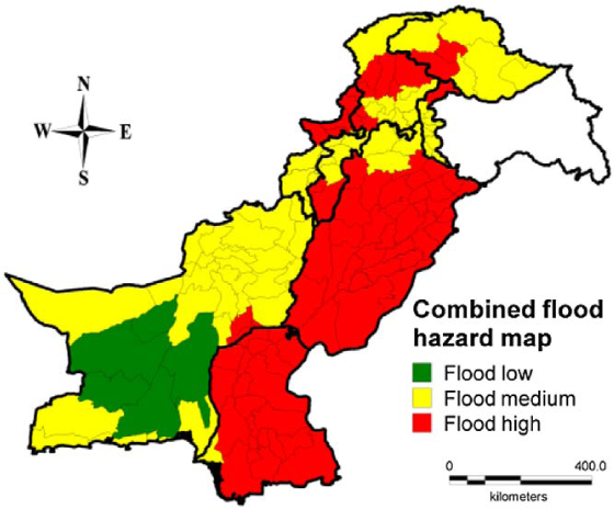
Combined flood hazard map (Siddique and Schwarz 2012).
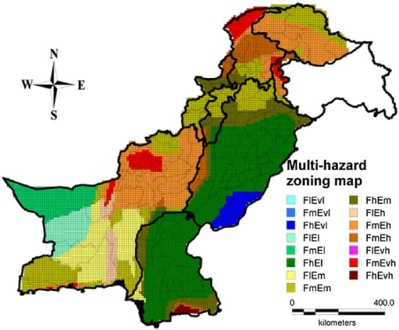
Multi-hazard zoning map of Pakistan (Siddique and Schwarz 2012).
Classification of the Multi-Hazard Zoning Map
The multi-hazard zoning map is further classified into four groups: earthquake hazard–dominated areas (EHDA), flood hazard–dominated areas (FHDA), combined hazard–dominated areas (CHDA), and no hazard–dominated areas (NHDA; see Figure 13). These classifications show that in Punjab and Sindh Provinces, flood hazard is dominant, whereas in Khyber Pakhunkhwa, Gilgit-Baltistan, FATA, and AJK Provinces, combined hazard is dominant. In general, in Balochistan Province, combined hazard is dominant, along with regions for FHDA, NHDA, and EHDA as well.
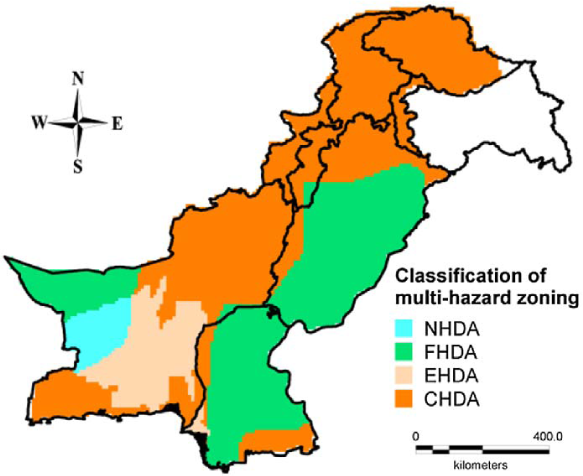
Classification of multi-hazard zoning map (Siddique and Schwarz 2012).
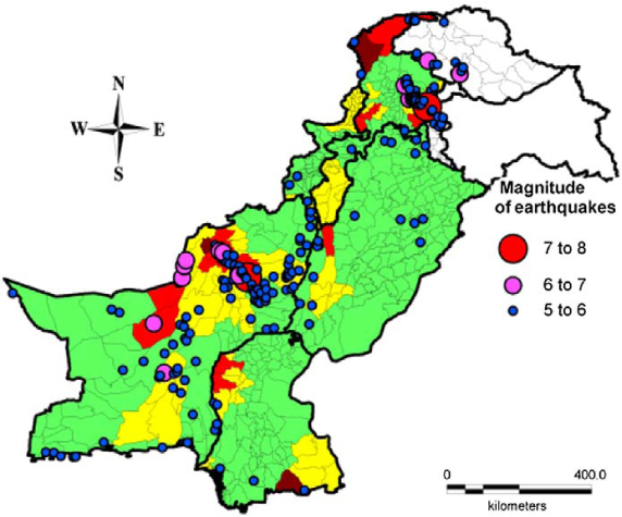
Figure 14 shows the epicenters of the earthquakes greater than magnitude 5 (up to depth of 50 km) between 1973 and 2013, along with EHDA and CHDA. It is clear that most of the earthquakes lie in EHDA or CHDA (validating the classification of multi-hazard zoning).
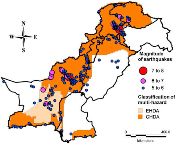
EHDA and CHDA with epicenters of earthquakes, from 1973 to 2013, with magnitude > 5 (USGS 2013).
Distribution of Typical Building Types in Pakistan
Typical Building Types in Pakistan
A census was conducted by the government of Pakistan in 1998, and in its data, the buildings were categorized based on the construction material used in outer walls and the construction material used in roofs. Maqsood and Schwarz (2008a) have introduced five typical building types in Pakistan, based on the combination of these two categories (see Figure 15): adobe, stone masonry, concrete block masonry, brick masonry, and timber. Reinforced concrete (RC) frame structures are only available in urban areas, and their percentage is considerably smaller, compared to other building types. Therefore, they were merged in brick masonry.
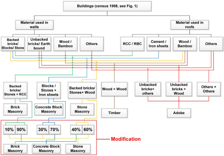
Flow chart of building type definition and modification for Khyber Pakhtunkhwa (KPK), Federally Administrated Tribal Area (FATA) and Balochistan.
According to Maqsood and Schwarz (2008b), in the areas affected by the 2005 Kashmir earthquake, adobe was most common building type in rural areas, stone masonry as the second most common form, along with concrete block masonry and brick masonry in almost equal proportions. This observation was confirmed later by Naseer et al. (2010).
In the northern part of Pakistan, which mostly consists of mountainous terrain, and where building stones are more abundantly available than any of the alternate building material, people commonly construct single story stone masonry buildings for residential purpose. The approximate distribution of common types of such buildings is considered as: stone masonry houses without mortar with earthen roof, 10%; stone masonry houses in mud mortar with earthen roof, 40%; stone masonry houses in cement mortar with earthen roof, 10%; stone masonry houses in cement mortar with GI sheet roof, 30%; stone masonry houses with reinforced cement concrete (RCC) roofing, 10%. It is clear from the above-mentioned distribution that 60% of stone masonry houses have earthen roofs, 30% have GI sheet roofs, and 10% have RCC roofs (Ali and Muhammad 2007).
Based on the above study, the authors have modified the definition of stone masonry buildings (10% of backed bricks/stones with RCC roof, 30% of blocks/stones with iron sheet roof, and 60% of backed bricks/stones with wooden roof are combined to represent stone masonry) in the KPK, FATA, and Balochistan Provinces. The change in the stone masonry definition leads to the modification of brick masonry and concrete block masonry as well.
Punjab and Sindh Provinces are topographically located in plane areas. In these provinces, brick masonry is a more dominant building type compared to stone masonry, because stones are not readily available. Therefore, for these provinces, the definitions of stone masonry are modified (10% of backed bricks/stones with RCC roof and 10% of backed bricks/stones with wooden roof are combined to represent stone masonry; see Figure 16). Concrete block masonry and brick masonry are accordingly modified as well.
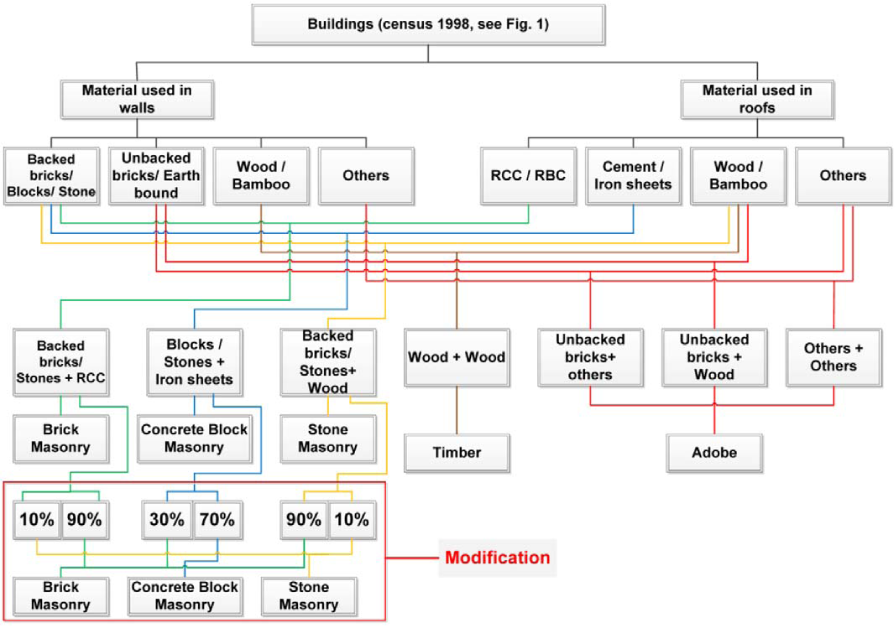
Flow chart of building type definition and modification for Punjab and Sindh.
Distribution of Building Types in Different Hazard-Dominated Areas
After estimating distribution of building types in Pakistan, and assigning different hazard-dominated areas (EHDA, FHDA, CHDA, and NHDA) from the multi-hazard zoning map of Pakistan, the aim is to estimate the total number of buildings and their distribution in each hazard-dominated area. There are different hazard-dominated areas in each province; the population density and building type distribution are varying as well. Therefore, the total number of buildings and their distributions are calculated, separately for each province and for each hazard dominated area (see Figure 17).
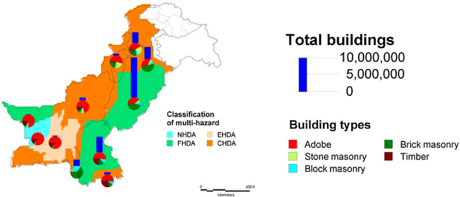
Total number of buildings and their distribution in different hazard dominated areas.
In Punjab and Sindh Provinces, there are two types of hazard-dominated areas (FHDA and CHDA). In KPK and FATA, there is only the CHDA, whereas in Balochistan Province, all four types of hazard-dominated areas are present. The majority of the buildings are exposed to the FHDA (particularly in Punjab and Sindh Provinces), followed by the CHDA and the EHDA; an insignificant amount of buildings are exposed to NHDA. The distribution of typical building types of Pakistan in each hazard dominated area (separately for each province) is also shown in Figure 17. According to it, in FHDA, brick masonry is dominant in Punjab, whereas adobe is dominant in Sindh and Balochistan. In EHDA, CHDA, and NHDA, adobe is the dominant building type.
Building Type Regions Map of Pakistan
Figure 18 shows the distribution of total number of adobe and brick masonry buildings at the tehsil level. For simplicity and further analysis, the percentage distribution is globalized, considering three quantitative terms (few, many, most), as proposed in EMS-98 by Grünthal et al. (1998; see Figure 19). The reason—to generate a coarse map (instead of a refined map in terms of percentage)—is to make it easier to group areas, with one or more dominant type of buildings. Building types are abbreviated as A (adobe), SM (stone masonry), CBM (concrete block masonry), BM (brick masonry), and T (timber) in Figure 19.
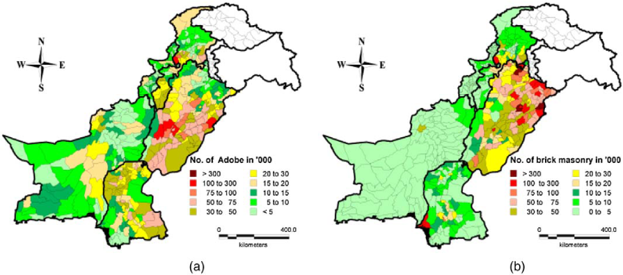
Total number of buildings at the tehsil level, (a) adobe and (b) brick masonry.
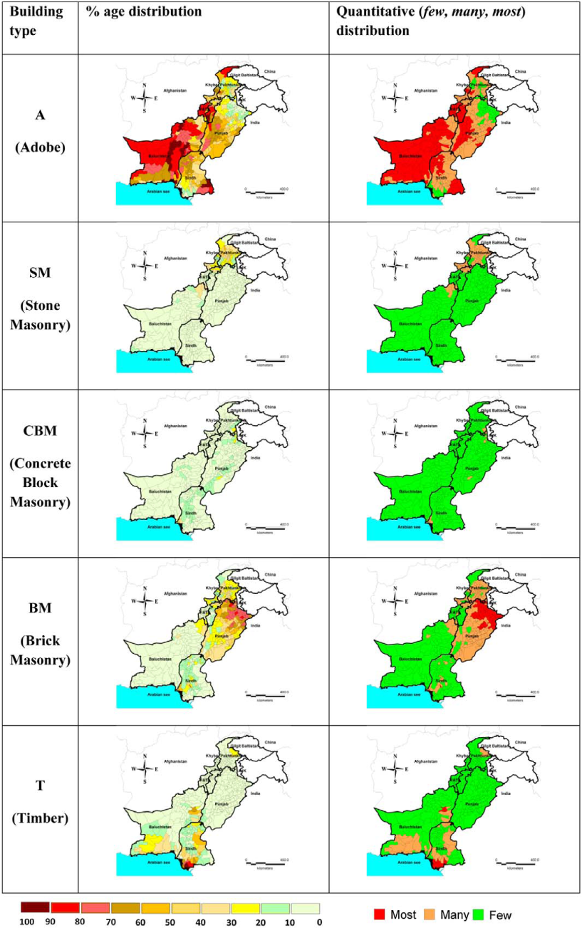
Typical building types in Pakistan in terms of percentage and quantitative ranges (few, many, most).
It is clear from Figures 18 and 19 that there is a specific trend of a certain building type in each province. Using these trends, seven regions can be defined by considering different combinations of few, many, most ranges in the five building types of Pakistan (see Table 3). Building types, defined in Figure 19, are combined together to generate a single map, representing all the building types, in terms of building type regions (see Figure 20).
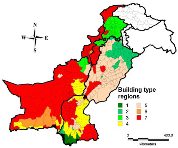
Building type regions map of Pakistan.
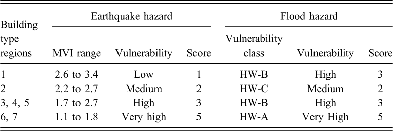
Maqsood and Schwarz (2008b) established the mean vulnerability index (MVI) for the building types in Pakistan. For calculating the MVI, a number from 1 to 6 is assigned for each vulnerability class from A to F, and the mean is calculated using different percentages of each vulnerability class. The lower the MVI, the higher is the vulnerability of the buildings to damage. Table 4 shows the MVI ranges and associated weighted scores, for different building-type regions. The vulnerability of building type region 1 is Low; region 2 is Medium; regions 3 to 5 are High; and regions 6 and 7 are Very High (see Table 4). The weighted scores are accordingly assigned, depending on vulnerability level.
Vulnerability and associated weighted scores for different building type regions
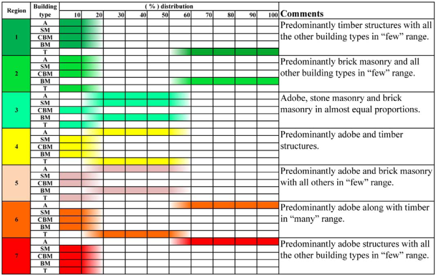
Schwarz and Maiwald (2008) introduced five flood vulnerability classes, ranging from higher-vulnerability class “HW-A” to the completely flood-resistant “HW-E.” A generalization of the concept and the basic steps of its extension to other natural hazards is discussed by Schwarz and Maiwald (2012). These vulnerability classes are compared with the vulnerability of building stock in Pakistan, and appropriate vulnerability classes are assigned to different building type regions, depending on the distribution of typical building types of Pakistan, in different regions. Building-type regions 1, 3, 4, and 5 are assigned vulnerability class HW-B; region 2 is assigned vulnerability class HW-C; and region 1 is assigned vulnerability class HW-A. Appropriate weighted scores are assigned based on vulnerability classes (see Table 4).
Total Number of Buildings in Pakistan at the Tehsil Level
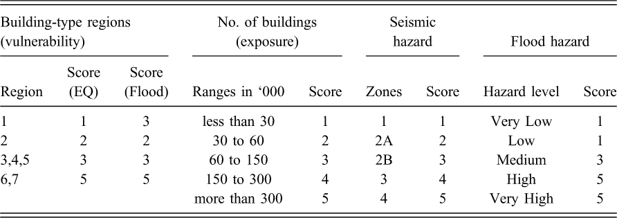
The total number of buildings at the tehsil level in Pakistan, according to the 2010 estimates (HRP 2012), are shown in Figure 21. It is estimated to be an almost 35% increase in number of buildings, as compared to the 1998 census data. Punjab is the most populated province in Pakistan, and Balochistan is the least populated. Population plays an important role, in establishing exposure factor, against a particular hazard in an area. The weighted scores, ranging from 1 to 5, are assigned (see Table 5), based on the ranges of number of buildings defined in Figure 21 (with lowest score for almost all the tehsils in Balochistan and highest score for tehsils having big cities).
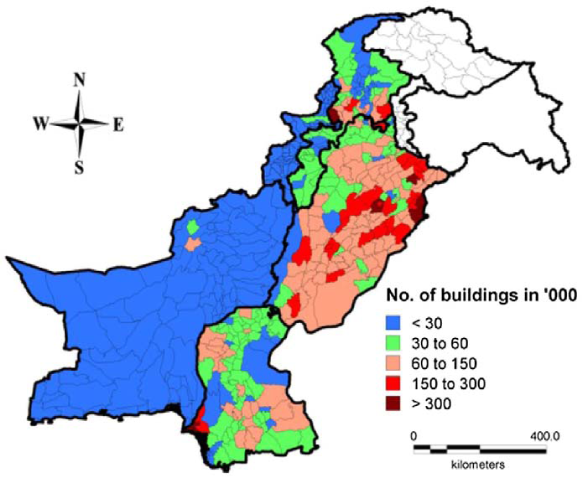
Total number of buildings at the tehsil level of Pakistan (HRP 2012).
Vulnerability and associated weighted scores for different building type regions
Qualitative Approach for Weighted Risk Maps of Pakistan
After establishing the building-type regions of Pakistan, multi-hazard zones, and total number of buildings in each tehsil, all the information is combined together to form risk maps of Pakistan, based on different scorings assigned to each category. A weighted score of 1 to 5 is assigned to building type regions, total number of buildings in each tehsil and for both earthquake and flood hazards.
Figure 22 shows the earthquake risk map in terms of weighted risk factor. It is represented as an envelope of seismic hazard, building vulnerability (in terms of building type regions), and exposure (in terms of total number of buildings at the tehsil level). There are four levels of risk defined, ranging from Low to Very High. The tehsils with High and Very High risk are mostly located in seismic zone 4 (northern parts of Balochistan and KPK provinces). In Sindh and Punjab Provinces, the earthquake risk factor is low, except in some tehsils where seismic hazard and building vulnerability have increased the risk factor to Medium and High.
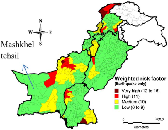
Sequentially established risk map of Pakistan; consideration of earthquake hazard only.
Figure 23 shows the epicenters of the major earthquakes (magnitude greater than 5, from 1973 to 2013), overlaid on an earthquake risk map. It clearly shows that the tehsils in the medium to very high-risk range had experienced big earthquakes in the past. The higher the risk in a particular tehsil indicates higher expected damage, in the case of future earthquakes. The proposed earthquake risk map can be used as a guideline for disaster risk management in Pakistan. A comparison between Figures 20 and 22 shows that in high-risk areas, adobe is the most dominant building type (building type region 7). The improvements in the building types can be realized, by replacing adobe buildings with brick masonry buildings having seismic band or confined masonry buildings. Improvement in the layout of the buildings, in both plan and elevation, and using simple construction rules, can also effectively contribute to the reduction of the vulnerability of the buildings.
Earthquake risk map with epicenters of major earthquakes (from 1973 to 2013, having magnitude > 5).
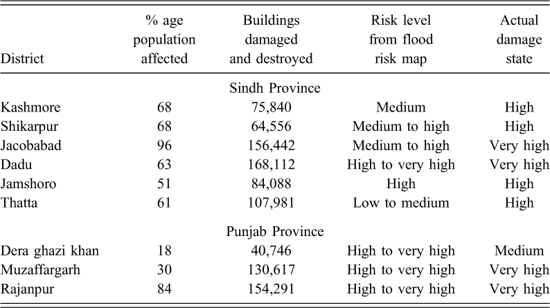
Figure 24 shows the resulting risk map, considering the flood hazard only. Four levels of risk are defined (ranging from Low to Very High), similar to earthquake risk map. The risk map is validating (by indicating high to very high risk) the FHDA defined in Figure 17. Most of the tehsils of Punjab and Sindh Provinces are under High risk due to floods (with some having Very High risk as well). In KPK Province, risk level, in general, is high, whereas in FATA and Balochistan Provinces, risk level is low (with the exception of some tehsils in FHDA). The proposed flood-risk map is a useful outcome for disaster risk management (by knowing High to Very High risk areas) in future. As a case study, Table 6 shows the total number of damaged and destroyed buildings, in the 2010 flood, in some of the severely affected districts, along with the prediction of risk from the map shown in Figure 24. In most of the districts, the risk level, proposed in the flood risk map, is equivalent with the observed damages in the 2010 flood.
Summary of weighted scores for different categories
Number. of buildings damaged and destroyed in the 2010 flood and its comparison with flood risk map (
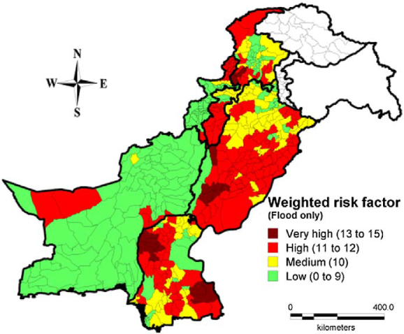
Sequentially established risk map of Pakistan; consideration of flood hazard only.
Figure 25 shows the weighted risk map, considering a multi-hazard approach, by combining both earthquake and flood hazards. This map indicates very high risk in some tehsils of Punjab, Sindh, and KPK Provinces. It is due to a combination of high hazards, as well as to a higher percentage of adobe buildings (having very high vulnerability against both hazards, see Figure 20). A medium-to-high risk is indicated in most of the FHDA of Punjab and Sindh Provinces. In Balochistan Province, seismic hazard is mainly contributing in the multi-hazard risk map (showing medium to high risk in higher seismic zone areas).
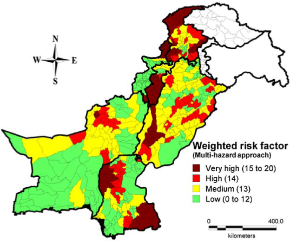
Sequentially established risk map of Pakistan; multi-hazard consideration.
Recent Earthquake on 16 April 2013
According to the USGS, the 7.8 magnitude earthquake of 16 April 2013 struck east of Khash, Iran (very near to Iran-Pakistan border), at 10:44 GMT, at a depth of almost 80 km below the surface of earth. In Pakistan there are reports (NDMA 2013) of at least 35 people dead and 180 injured in Mashkhel area (district Washuk; see Figure 22). Approximately 700 houses (NDMA 2013) have been reported to be damaged. In Mashkhel tehsil, about 87% buildings are adobe (mud houses with wooden roofs; see Figure 20 for building-type regions). The earthquake was of a very high magnitude, but a smaller amount of damage occurred, mainly due to the fact that, in Iran it occurs in desert area, and in Pakistan this area of Balochistan province is sparsely populated (see Figure 21). It is also evident from the risk map that Mashkhel tehsil is in low risk, considering earthquake hazard (see Figure 22).
There is another important point to note here that the seismic zoning map, prepared by Building Code of Pakistan, shows a low seismic hazard in this region of Balochistan, whereas GSHAP seismic zoning map shows a very high value of PGA in this region (see Figures 2 and 3). It concludes that Pakistan's seismic zoning map is underestimating the earthquake hazard in southern part of Balochistan (near the border with Iran), and appropriate changes in the seismic zoning map should be made.
Conclusions
Pakistan has suffered from a couple of major natural disasters in the last decade. Although earthquakes have been major concern in the region, huge damage caused by floods in 2010 and 2011 emphasize the fact that considering a single event for the risk assessment of the building stock in Pakistan is not enough. An effort has been made to develop a multi-hazard zoning map of Pakistan, considering both earthquake and flood hazards. It is further classified into four types, based on the severity of flood or earthquake hazard in different parts of the country.
Earthquakes and floods have different return periods, so the maps are also available for different return periods. For earthquake hazard, a seismic zoning map is available, which is based on a 475-year return period. The flood hazard map, by the WHO, is based on a 25-year return period. The probability of floods is greater than that of earthquakes; therefore, buildings should be designed considering both aspects. A comparable treatment is given to both hazards (using appropriate weighting scores), as individual treatment will not solve the problem of multi-hazard risk assessment.
According to the distribution of building types into different hazard-dominated areas, it is clear that FHDA has the most number of buildings exposed to any hazard, and it also contains high percentage of adobe structures. Particularly in Sindh Province, adobe is the predominent building type in FHDA and that was one of the reasons for the huge damage resulting from the 2010 flood.
An effort is made to create a new building-type regions map of Pakistan, by combining five maps of typical building types of Pakistan. The map proves to be a reliable basis for establishing qualitative weighted risk maps of Pakistan, considering earthquakes and floods seprately, as well as a multi-hazard approach. It is a qualitative approach, by using the information at the tehsil level without analytical considerations. These risk maps can be used as a guideline for disaster risk management, by identifying tehsils in High to Very High risk, and consequently suggesting improvements for the building types in those tehsils. Analytical vulnerability assessment can improve these risk maps.
The multi-hazard map and risk zoning maps are time-dependent and might be subjected to changes due to future events, which can also have an impact on the building stock. After the 2005 Kashmir earthquake and the 2010 flood, the building-type distributions all over Pakistan have changed. Updates and refinements to the database (after each big event) are required for a further qualification of the risk mapping. One such modification becomes evident from the 16 April 2013 (Iran-Pakistan border) earthquake; it indicated that the seismic zoning map proposed by Building Code of Pakistan underestimates the earthquake hazard near the epicenter of that earthquake (when compared to GSHAP seismic zoning map). A new census is also required to provide knowledge about the changes in building types after the recent natural disasters over last decade in Pakistan.
The proposed multi-hazard risk assessment procedure can be extened to other countries. The weighted scores for earthquake hazard can be adjusted based on PGA values of a given study area. Also, for regions with a very high risk of flood hazard, the weighted scores can be increased accordingly. The weighted scores for vulnerability and exposure consideration can also be appropriately modified to include the local conditions.
Footnotes
Acknowledgements
The authors would like to express their thanks to the editor and anonymous reviewers for their very valuable comments and suggestions, which led to the clarification of whole procedure and its application to the study area.