






Abstract
Tourism travel is a prevalent form of leisure and entertainment. This paper provides a brief overview of an attraction route planning algorithm based on multi-source data, which combines multi-source data to assess the effectiveness of the planned route and utilizes the particle swarm optimization (PSO) algorithm for path optimization. The genetic algorithm (GA) operations were incorporated with the PSO algorithm to enhance optimization performance. Subsequently, simulation experiments were conducted to compare the GA-PSO algorithm with using the PSO algorithm and GA. Moreover, a comparative analysis was performed on the performance of the path planning algorithm using single-source and multi-source data. The results demonstrated that the GA-PSO algorithm exhibited the fastest convergence in optimization search and achieved the best fitness value at stabilization. Among the three path schemes, the GA-PSO algorithm performed the best, followed by the GA, while the PSO algorithm was found to be the least optimal. Furthermore, path planning with multi-source data demonstrated better alignment with tourists’ landscape preferences, enabling personalized routes construction.
Introduction
With the advancement of the social economy and the progress of science and technology, tourism has become a pivotal means of leisure and entertainment for people [1]. When choosing attractions during travel, tourists no longer rely solely on their popularity or distance from each other [2]. Instead, there is a growing emphasis on enhancing both quality and depth when planning attraction visits and routes. The utilization of multi-source data to optimize attraction routes has emerged as a critical area for research, harnessing big data technology to drive rapid development within the tourism industry [3]. Wu et al. [4] put forward a tourism experience utility function and used it to establish an optimization model for tourism route planning. The experimental results revealed the substantial impact of preference for tourism attractions, attention to the timing of tourism, and cost on route planning. Tang et al. [5] introduced an enhanced hierarchical fuzzy reasoning approach based on the c-measure map matching algorithm and verified its effectiveness and superiority. Yu et al. [6] optimized the logistics distribution path algorithm based on actual demand. The resulting three-dimensional constraint model-optimized algorithm reduced distribution mileage by over 25% compared to the genetic algorithm (GA). This paper provides a brief overview of an attraction route planning algorithm based on multi-source data. The algorithm integrated multi-source data to assess the quality of the planned route. The particle swarm optimization (PSO) algorithm was used for path optimization, and GA operations were introduced to enhance optimization performance. Subsequently, simulation experiments compared the GA-PSO algorithm with the PSO algorithm and the GA. Furthermore, the performance of the path planning algorithm under single-source and multi-source data conditions was also compared. This article enhanced the PSO algorithm for tourist route planning by incorporating genetic operations from GA. The optimization process utilized multiple sources of data to evaluate the quality of the planning solutions, providing effective support for convenient travel for tourists. The novelty of this study lies in utilizing genetic operations from GA to address the issue of particles getting trapped in local optima in the traditional PSO algorithm, thereby enhancing its optimization capability. However, limitations include a lack of diversity in the types of data used to measure solution quality and a simplistic approach to constraining search ranges with simple conditions.
Algorithm for attraction route planning based on multi-source data
When planning routes for tourist attractions, if the number of attractions and the connections between them are relatively small, the traversal method can be employed to plan routes and select the optimal few [7]. However, when confronted with a large number of attractions and intricate routes between them, the computational load of the traversal method increases significantly. Furthermore, traditional route planning methods often evaluate the planning scheme based on a single criterion, such as shortest length or least time consumption, making it challenging to cater to individual tourist preferences. Therefore, this paper adopts a multi-objective optimization approach for attraction routes by leveraging multi-source data such as tourists’ visit history, road network structure, and attraction popularity [8].
For the problem of route planning for tourist attractions, it can be considered as a route optimization problem. The PSO algorithm can be used to solve it. The PSO algorithm is an optimization algorithm based on cooperation that simulates the foraging behavior of bird flocks. The basic principle of the PSO algorithm’s optimization process lies in the collaboration and information sharing among different individuals within the population. Each particle represents a potential solution, and its movement direction and speed are determined by its own experience and the collective experience of the group. The advantages of the PSO algorithm lie in its simplicity, ease of implementation, lack of many parameter adjustments, and fast convergence speed. Particles in the PSO algorithm possess two attributes: velocity and position. The stronger the fitness represented by a particle’s position, the greater its attraction to other particles. Velocity is determined by both individual experience and collective experience, which are derived from the quality of the particle’s current position. In other words, for the PSO algorithm, a particle’s position directly influences the movement trend of the particle swarm. Consequently, once a particle occupies a relatively optimal position, it will attract other particles and hinder their search for even better positions, potentially leading to being trapped in local optima.
GA is an optimization algorithm based on the principles of biological evolution that mathematically simulates natural selection and genetic mechanisms. In GA, operations such as replication, crossover, and mutation are performed on chromosomes. Replication preserves excellent solutions while crossover and mutation generate new solutions. These two operations, especially mutation, can be considered sudden changes for individual chromosomes. The dilemma of local optima faced by the PSO algorithm occurs because other particles are attracted to the local optimum particle, resulting in the overall velocity trend of the particle swarm pointing towards a local optimal solution. To solve this dilemma, it is necessary to allow other particles to break free from the influence of local optima after being attracted. Therefore, this paper introduces genetic operations from GA. After one iteration by the PSO algorithm, although a local optimal particle is not globally optimal, it is still a relatively excellent particle and should not be discarded directly. Hence, the replication operation in genetic operations can be used to preserve it. Other particles undergo position changes through crossover and mutation operations to escape its influence. During this process of change, on one hand, they can break free from the attraction of local optima particles, and on the other hand, these changed particles may end up in even better positions, thereby overcoming the dilemma of being trapped by local optima.
Path planning flow of the GA-PSO algorithm based on multi-source data.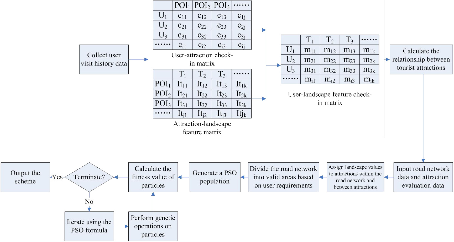
The planning flow of the GA-PSO algorithm for traveling paths combined with multi-source data is presented in Fig. 1.
Multi-source data such as tourists’ visit history information, basic information for points of interest (POI), and road network information are collected. Based on the historical visit information of tourists to attractions, a user-attraction check-in matrix is constructed, as shown in Fig. 1 [9]. The relationship between attractions is calculated based on the three constructed matrices. The user-attraction check-in matrix reflects the proximity of attractions from the tourists’ perspective, while the attraction-landscape feature matrix represents the similarity between attractions in terms of landscape features. By combining these two matrices, the degree of relationship between any two attractions can be determined. Road network data and online evaluation data of attractions are input. Landscape values are assigned to the attractions in the road network as well as the edges (paths) between attractions. The landscape value of attractions can be divided into inherent landscape value and personalized landscape value. The inherent landscape value of an attraction is determined by online evaluations, including tourist ratings, attraction level, and number of uploaded photos. The higher these feature values are, the higher the inherent landscape value will be. Personalized landscape value is the landscape value viewed from the perspective of individual tourists, where the cosine similarity between the landscape feature vector of an atttraction and the tourist’s preferred landscape feature vector is used as a reward factor to enhance the inherent landscape value. The landscape value of an edge depends on the neighboring attractions. The greater the number of neighboring attractions, the higher the landscape value, the stronger their interrelationships, the higher the landscape value of the edge. The calculation using personalized landscape values can be conducted to obtain personalized landscape preferences. Based on user demands, the valid area is delineated within the road network to reduce the search scope for optimal pathfinding. In this context, user demands refer to reaching the destination within a specified time limit. A circle is drawn by taking the starting point and the endpoint given by the user as the center of the circle and a certain length as the radius during the division of valid areas. The intersection of the two circles is the search area. The length is determined by the speed at which tourists travel and the designated time limit. Population particles are randomly generated. The coordinates of each particle are a path planning scheme. The corresponding constraints also need to be adhered to when randomly generating the particle scheme:
where The fitness value of the scheme represented by each particle is calculated:
where Whether the optimization search is terminated or not is determined. if it is terminated, the optimal path scheme is output; if not, proceed to the next step. The termination conditions include reaching the maximum number of optimization iterations and the convergence of population fitness values to stability. The population particles are iterated [14]:
where
Experimental data
Statistics on the road network, attractions, and tourists
Statistics on the road network, attractions, and tourists
The road network data for Nanyang City, Henan Province, utilized in the simulation experiments were sourced from the OSM platform. Prior to formal usage, the data underwent a cleaning process. Attraction data were acquired through a crawler program from “Tongcheng Travel (
The relevant parameters of the GA-PSO algorithm for path planning were set as follows. The population size was 20,
In the process of the simulation experiment, taking into account the average speed of driving in daily life and the amount of time tourists are willing to spend on the road, the average speed of tourists’ driving was set to 25 km/h, and they were requested to reach the endpoint in 1.5 h. One starting point and one ending point were randomly selected from the attractions, and the above three path planning algorithms were used to obtain the planning scheme from the perspective of the same tourists, and the advantages and disadvantages of the path schemes under the three algorithms were compared.
Once again, one starting point and one ending point were randomly selected from the attractions, and the GA-PSO algorithm was used to plan the path scheme for one tourist. To verify the usefulness of multi-source data for personalized route planning, another path planning algorithm using only road network data was used to plan a path scheme for the same tourist. The difference between the path planning algorithm using single-source data and multi-source data was that only
Experimental results
The convergence curves of the three algorithms for the same tourist are depicted in Fig. 2. It can be observed that all three algorithms converged as the number of iterations increased during the optimization process. The landscape value of the planning schemes gradually rose and stabilized, while travel time gradually decreased and stabilized. Notably, among the three algorithms, the GA-PSO algorithm exhibited the swiftest convergence, achieving stability after approximately 25 iterations. Moreover, it attained both highest landscape value and shortest travel time once convergence was stabilized.
Advantages and disadvantages of planning schemes under the three planning algorithms for the same visitor
Advantages and disadvantages of planning schemes under the three planning algorithms for the same visitor
Convergence curves of three algorithms during optimization.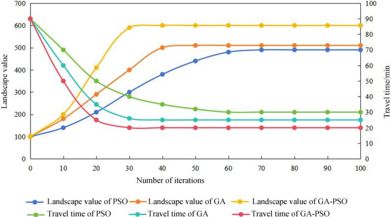
The comparative results of the algorithms for the same tourist route are summarized in Table 2. Analysis of Table 2 indicated that the GA-PSO algorithm performed the best in terms of landscape value, travel time, and computation time compared to the GA and PSO algorithms, which were ranked second and third respectively. The “average cosine similarity to users’ preferences” reflected the alignment between the landscape feature types of attractions in the planned path and users’ preferences. The data in Table 2 revealed that the cosine similarity of the planning scheme under the GA-PSO algorithm was slightly higher, but there was no significant difference compared to the other two planning schemes. This suggested that all three path planning schemes were well aligned with tourists’ preferences.
The comparison results of the GA-PSO algorithm, which uses only road network data as a single source for path planning, and the path solutions obtained from using multiple sources of data are shown in Table 3. Table 3 reveals that, concerning “travel time” and “computation time”, the scheme employing multi-source data held an advantage, but the advantage was not significant. In terms of “landscape value” and “average cosine similarity”, the path planning scheme incorporating multi-source data exhibited clear advantages. The scheme utilizing multi-source data not only boasted a higher landscape value but also aligned more closely with tourists’ preferences for landscape.
Advantages and disadvantages of planning schemes under the GA-PSO algorithm using single-source data and multi-source data
This paper provides a brief introduction to an attraction route planning algorithm based on multi-source data. The algorithm combined multi-data sources to evaluate the effectiveness of the planned route. The PSO algorithm was used for path optimization, and GA operations were incorporated within the PSO algorithm to enhance optimization performance. Subsequently, simulation experiments compared the performance of the GA-PSO algorithm with both the PSO algorithm and the GA. The performance of the path planning algorithm using single-source and multi-source data was also compared. All three algorithms exhibited convergence with an increase in iterations. The landscape value of the planning scheme gradually increased and stabilized, while the travel time decreased and stabilized. Notably, the GA-PSO algorithm demonstrated the fastest convergence, achieving the highest landscape value and the lowest travel time after stabilization. In terms of landscape value, travel time, and algorithm computation time, the GA-PSO algorithm performed the best, followed by the GA and the PSO algorithm. However, their difference in “average cosine similarity to users’ preferences” was not significant, and all the schemes aligned well with tourists’ preferences. Regarding “travel time” and “computation time”, the scheme using multiple data sources for planning held a slight advantage. In terms of “landscape value” and “average cosine similarity”, the planning scheme that utilized multi-source data demonstrated superiority.
Footnotes
Funding
This work was supported by Key Specialized Research and Development Program in Henan province in 2022, Project name: Smart Tourism Technology Research and Development Based on Big Data Development and Machine Learning Algorithm (222102320115).