
Abstract
Mineral sand deposits being economically exploited around the world fall into three main deposit styles; palaeo shorelines and marine placers, dunal and aeolian deposits, and alluvial deposits. Resource estimation for mineral sands follows standard estimation principles as applied to commodities throughout the Mineral Resource sector. There are, however, characteristics of mineral sands that require a slightly different approach and more emphasis on the geometallurgical characterisation to support the evaluation, Resource estimation and eventual reporting of the Mineral Resource estimate. Drilling is the main exploration and Resource definition tool used in the mineral sands industry and aside from logging and sampling, observation of hardness and induration attributes are critical aspects of drilling mineral sands deposits. Assaying is conducted on drill samples for heavy mineral (HM) content and for various particle size ranges and then further assaying or mineralogical assessment is undertaken on the HM to determine valuable heavy mineral components (typically zircon, ilmenite, rutile). The estimation of mineral sands resources requires a sound geological model before the determination of any geometallurgy based sub-domains within the mineralisation. Understanding the mineralogy and quality characteristics of deposits influences the confidence in subsequent Mineral Resource and Ore Reserve estimation and will in turn assist the Competent Person to select the appropriate cut-off-grade for Mineral Resource reporting.
Introduction
Mineral sand deposits being economically exploited around the world fall into three main deposit styles; palaeo shorelines and marine placers, dunal and aeolian deposits, and alluvial deposits.
Resource estimation for mineral sands follows standard estimation principles as applied to commodities throughout the Mineral Resource sector. The basic principles of Resource estimation, as with any other commodity, are required to be followed. Assessment of all the assay data, sound geological interpretation, appropriate supporting levels of quality assurance and quality control (QA/QC) data and robust geological model construction are as critical for mineral sands Resource estimation as any other commodity.
There are, however, characteristics of mineral sands that require a slightly different approach and more emphasis on the geometallurgical characterisation to support the evaluation, Resource estimation and eventual reporting of the Mineral Resource estimate.
Mineral sands resource estimation
As for many commodities, the estimation of mineral sands resources requires a sound geological model. Ideally the geological interpretation is completed before any major sampling for the requisite mineral and quality analysis as well as any bench top and pilot plant scale recovery test work.
The geological interpretation is focused on identifying the geological setting, which could comprise arcuate palaeo shorelines, larger amorphous aeolian dunal masses, offshore marine sand accumulations or irregular lacustrine and alluvial deposits. The geology that hosts mineralisation may be normally stratified or tightly constrained within geological boundaries and domains. There can often be combinations of geological settings such as palaeo shorelines on lapping with coastal dunal deposits. Identifying these geological settings will predicate the number and distribution of metallurgical composite samples which in turn can be significant in terms of financial and time requirements.
The primary grade variables that a practitioner would want to interpolate into a mineral sands block model would be heavy mineral (HM), valuable heavy mineral percentages (assemblage), mineral qualities (chemistry) and material sizing characteristics such as the proportions of oversize (e.g. >2 mm), slimes (e.g. <53 μm) and sand (>53 μm <2 mm) as well as rock or induration characteristics recorded during logging of drill samples.
The majority of mineral sand estimators have opted to keep the process simple with respect to mineral sand estimation techniques. There are many excellent papers by respected practitioners on what to do, and what not to do, during block model estimation, and the mechanics of model construction and estimation are well established across the Resource sector.
Data preparation and inputs
Drilling, sampling and logging
Drilling
Drilling is the main exploration and Resource definition tool used in the mineral sands industry. Usually small, four wheel drive-mounted reverse circulation air-core (RCAC) drilling rigs are used. Auger drilling was commonly used before the advent of RCAC in the mid to late 1970s. Triple tube diamond drilling has been used on occasions to collect samples for geotechnical investigations but often with limited success in recovering core from unconsolidated sediments. Recently, the use of Sonic drilling, which is based on high frequency vibration, has become popular for advanced geotechnical and metallurgical investigations and Resource definition drilling. Reverse circulation air-core is relatively cheap and allows for extensive exploration and Resource drill-out whereas Sonic drilling is significantly more expensive to conduct with considerably slower drill penetration rates which has limited its application in Resource definition drilling. Drill holes are typically vertical and drill rod sizes commonly range from AQ to NQ for RCAC and from 10 to 15 cm for Sonic drilling (Jones, 2009). Drill spacing over mineral sand orebodies is generally able to be conducted on a regular grid. The geometry of many deposits can be established at an early stage in the exploration process from the geometry of palaeo shorelines and the initial broad-spaced drilling.
Drill grids are generally aligned in fence lines perpendicular to the strike of the deposit. Holes are typically spaced at 10 to 100 m on the drill lines, which are in turn typically spaced at intervals of 50 to 800 m. This spacing will be dependent on the continuity and dimensions of the deposit and morphology and homogeneity of both the HM grades and the potentially saleable mineral species (valuable heavy mineral or VHM, refer Table 1; Jones, 2009). For example, narrow high-grade strandlines typical of the Murray Basin will require closer-spaced drilling across strike but wider-spaced drilling along strike.
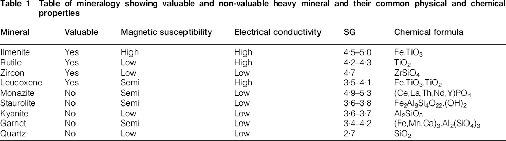
Table of mineralogy showing valuable and non-valuable heavy mineral and their common physical and chemical properties
As a generalisation, exploration drilling will take place on wide-spaced drilling sufficient for the development of an Inferred Mineral Resource. Resource definition drilling will generally be carried out on exploration identified targets or deposits that have passed a high-level test of potential economic viability. This phase of drilling (in one or multiple campaigns) will take a deposit into the Indicated and then potentially to the Measured Mineral Resource category (all supported by the progressive development of the mineralogy and other key criteria). Variogram analysis is often used to assist in determining the nature of the HM grade continuity within a deposit and the sampling grid dimensions required for the reporting of Measured and Indicated Mineral Resources.
Drill hole collar locations are often accurately surveyed on site; however, if less accurate GPS locations are used the collar elevation is determined from digital terrain models (DTM) based on either shuttle telemetry, aerial photogrammetry or LiDAR (light detection and ranging) surveys.
Sampling
The RCAC drilling method – where air or water is forced down an annular tube and cuttings are returned up the central tube through a small cyclone – generally produces a clean, uncontaminated sample given ideal drilling conditions. Sub sampling of the RCAC drill samples is commonly conducted using a rotary splitter mounted below the cyclone to produce samples for assay. Sub samples typically weigh in the 1 to 3 kg range depending on drill diameter and ground conditions.
Sample quality may be compromised when drilling RCAC holes in unconsolidated sediments and where significant volumes of groundwater or induration are intersected. These conditions may lead to contamination of samples with material from outside the drill string in overlying intervals.
Contaminated samples may be identified if they cause unusual geometries or geometry variability, or where the logging and assay data indicate that apparently mineralised samples are sourced from geological units that are known to be barren and underlie the mineralisation. Where down hole sample contamination is identified at the base of mineralisation, the affected samples should be excluded from use in estimation. Deposits affected by down hole sample contamination require validation sampling (Sonic core or test pit) to confirm the interpreted mineralisation interval and the HM content.
Other issues that can impact RCAC sampling include poor or infrequent cleaning of sticky clay material from the cyclone, use of cyclones and splitters which have been incorrectly designed/damaged or have been set up poorly (e.g. configured to sample a very small proportion of the total sample return). Monitoring total sample return and sub sample weights can assist in identifying these issues as they arise.
Abzalov et al. (2011) presented a comparison study of reverse circulation aircore, Sonic and diamond triple tube drilling conducted at the Corridor Sands (Mozambique), Richards Bay (Republic of South Africa) and Fort-Dauphin (Madagascar) mineral sands deposits. This study found that RCAC samples ‘tend to be negatively grade biased, underestimating the HMs content, in particular when drilled intervals are located below the water table’ (Abzalov et al., 2011). The authors have experienced similar results from comparison Sonic sampling programs conducted on HM strand deposits located beneath the water table.
The Sonic drilling technique also experiences difficulties in obtaining representative sampling in some environments. Sample recovery is often dependent on the skill of the driller and the operation of the core catcher mechanism utilised at the base of the core barrel. Whereas the Sonic technique can comfortably drill hard rock or unconsolidated material it can be difficult to maintain sample recovery when both are present in the same sample interval as the core catchers can become dislodged by rock and allow the unconsolidated sand to fall out. When hard rock intervals are expected it may be necessary to core the interval without a core catcher, run the casing over the interval, retrieve the empty barrel and then run a core barrel with a core catcher attached back down the hole to retrieve the sample from the interval.
An issue that needs to be addressed during Sonic sampling is how to treat extra sample material that is recovered in the first drill rod above the core barrel. This material may comprise up to 25% of the sample volume in the core barrel, i.e. 125% core recovery from the interval drilled. Minor volumes of excess recovery often appear due to the expansion of clay material in the core barrel; however, significant extra sample volumes can be produced in unconsolidated sands under high hydraulic pressure. Options include reconciling the extra sample as part of the cored sample interval, discarding this material either at surface or by cleaning the hole to the previously drilled depth before commencing coring of subsequent interval.
The authors strongly concur with Abzalov et al. (2011) that none of the drilling methods currently used for the definition of Mineral Resources of HM sand deposits can guarantee flawless results.
Logging
Typically a small sub sample is taken from every drill sample which is panned with water to remove the clay and fines and then logged to record relevant geological information. As stated above, mineral sand resource estimation requires a sound geological model and significant information regarding the depositional setting of each sample can be observed during the logging of drill samples including: grain size distribution, clay content, induration type and content, estimated HM content and if samples are wet due to water injection or the presence of groundwater. Consideration of the logging data is critical in developing the geological model which will be used to constrain grade estimation.
As every sample is generally logged regardless of whether it is submitted for assay the logging data are extremely useful in constructing the geological model. Logging data can also assist in validation of assay data through the comparison of the HM estimates against the HM assay results, which can indicate the presence of trash HM (iron induration, iron cementation of quartz grains) where assays are significantly higher than the estimates.
Hardness logging can be a critical component of the logging and can be pertinent to both the geological interpretation and the identification of potential comminution issues for material processing. The logged hardness values are generally determined between the driller and the Geologist based on an agreed matrix. The assigned hardness value is generally representative of the hardest material within the sampled interval; however, detailed commentary can be captured by the logger that in turn can be valuable to the Resource estimator. It is also important to note the drilling equipment used, including the use of hammer, auger or Sonic core.
Assay data and quality assurance/quality control
Mineral sands do vary from other commodities with respect to the determination of the valuable components of mineralised orebodies as the assaying is often a three tiered process. Primary assaying is focused around determining the percentage of HM contained within a given sample, i.e. material with a specific gravity greater than 2·85 g cm−3. Other results of interest from the primary assay include clay fines or slimes (material generally less than 45 to 75 μm), sand (generally 45 μm or 75 μm to 500 μm or 2·0 mm) and oversize (generally greater than 500 μm or 2·0 mm). Assay of primary material sizes is not standardised across the industry as companies have often focused on a discrete range of sizing as a direct result of the unique physical sizing characteristics of key deposits and as a response to process metallurgy requirements (Jones, 2009).
Secondary assaying tends to focus on the mineral assemblage suite in determining the percentage of key valuable minerals such as ilmenite, zircon, rutile and leucoxene and the associated percentages of non-valuable minerals or gangue minerals such as garnet, staurolite, kyanite and monazite. Occasionally in conjunction with this assay determination, a tertiary level of analysis is carried out on individual mineral species in order to determine quality characteristics such as trace elemental contamination (e.g. uranium and thorium, chrome, manganese and silica) and sizing and rounding physical characteristics.
Any Mineral Resource estimation needs to take into account quality control and quality assurance (QA/QC) for sampling and assaying. The inclusion of this data is important to the practitioner as it gives confidence in the quality of assayed data to be used for the estimation. Typical QA/QC data sets in the mineral sands industry include reference standards, duplicate sampling and twin holes. Notably the fines material is lost during assaying and only the HM content within the retained sand fraction can be re-assayed which necessitates constant monitoring of standard results to detect any issues that may arise.
Mineralogical assessment
Assaying for mineralogy and mineral quality data often entails the selection of composite samples that incorporate multiple samples from within a defined geological or mineralogical domain. These domains are determined from the geological interpretation which is based on evaluation of field logging, assays and examination of HM fractions under a microscope. Microscope inspection of the HM sink fractions gives an indication of approximate assemblage composition, alteration of ilmenite and mineral coatings such as iron, silica and clay, the presence of rock and aggregates of quartz. Understanding the gross distribution of mineral assemblage grades and quality aids the selection of samples for detailed mineralogical assessment and metallurgical evaluation. Material for composite samples are then sourced from either HM sink fractions or HM bearing sand fractions produced during the drill sample assay process.
Composite mineralogy samples are the most commonly used throughout the industry for a number of reasons, not least being the cost of preparing the mineral assemblage composite analysis. The cost of a mineral assemblage composite analysis can range from $400 through to $2000, depending on whether the analysis is purely chemical analytical (scanning electron microscope, SEM) or a mixture of physical and/or gravimetric separation and chemical analysis (magnetic and electrostatic separation±Clerici/TMF (Thallium Malonate/Thallium Formate) heavy media separation coupled with X-ray fluorescence analysis). Extensive sizing analysis can also be an important component of the composite analysis.
The other driver behind compositing of samples is a minimum weight of HM that is required in order to conduct the analysis. This is less of an issue with SEM analysis, which can be conducted on small samples and generally more an issue with methodologies that require exploitation of the physical separation properties of the HM and larger quantities of HM.
It should be noted that mineralogical assessment is different from metallurgical evaluation. Mineralogical assessment involves determining mineral species, grain size and chemistry of a sample whereas the latter is more focused on determining recovery and separation efficiencies for selected processing techniques along with final product characteristics. The common minerals making up a typical HM assemblage are listed along with their typical physical characteristics (Table 1).
Data validation
It is imperative that any Resource development work is based on validated data. This applies to the interpretation of geological domains, selection of composite sample intervals for mineralogical work and for all the assay data that is to be estimated into a block model. The following provides a summary of the ideal approach to mineral sands data validation:
visual examination of spatial data: with particular reference to out of sequence holes, twin holes, outlier assays and irregular collar relative levels (RLs)
visual examination of attribute data: including analysis confirming the validity of the data ranges, absent data values, degree of assay correlation between twin holes, and investigation of outlier values
statistical analysis: including the use of validation histograms checking for features of normal and log-normal distributions (multi-population and skewed populations), analysis of domained and un-domained data (this can be an iterative step to check the validity of domained data), analysis and comparison of duplicate sample data sets from both field and lab data.
The integrity of drill hole collar RL is particularly important for mineral sand deposits given that they are generally shallow and often flat-lying whereby errors in the vertical survey may have significant impact on interpreted geometries. This is particularly so given that grade control drilling for mineral sand operations is rare and often the exploration and the Resource drill-out constitutes the only grade delineation that is undertaken on the deposit. It should be noted that grade control for mineral sands can be facilitated by the mine geologist through visual inspection, panning and supporting spot and channel sampling.
Interpretation of mineral sands deposits
The geological interpretation is focused on identifying the geological setting, which could comprise arcuate palaeo shorelines, larger amorphous masses that are aeolian or dunal, offshore marine sand accumulations or irregular lacustrine or alluvial deposits. There can often be combinations of geological settings such as palaeo shorelines on lapping with coastal dunal deposits.
As discussed above, the logging data is critical in developing the geological model which will be used to constrain grade estimation. Logging of the grainsize distribution, sorting and rounding, fines content and colour are used to determine the depositional setting (fluvial, marine) and to identify the components of a typical prograding beach sequence. For example, the data can help identify if marine sediments were deposited in a low energy offshore environment (fine to very fine grained, well rounded and well sorted sand), or within a surf zone (fine to very coarse grained, moderately to poorly sorted sand), or on a high energy beach (medium grained, well rounded and well sorted sand). This is supported by the use of material size data from the assayed samples.
Once the broad geological framework has been determined then the focus turns to identifying mineralised sub domains which may be used for selection of appropriate mineralogical composite samples and or domain boundaries during resource estimation. As discussed above, such domains can be identified through detailed microscope inspection of the HM sink fractions from the assay process. The following relationships are important for the Resource estimator to consider within the proposed domains:
the distribution of HM mineralogy or assemblage
the ratio of VHM to trash or non-VHM
correlation between HM assays and the field estimates of rock or induration
characteristics of the material sizing assay data (oversize, sand, slimes).
If there is not significant variability in the proportions of VHM through the deposit then simple geology or HM cut-off grade based domains can be used, with care taken not to overly complicate the interpretation beyond what is justified given the available data.
However, the presence of induration within or in the vicinity of the mineralised unit with a density greater than 2·85 g cm−3 can complicate the interpretation process. Pulverisation of indurated material by the drill bits and disaggregation during sample return can make indurated layers difficult to identify, hence the comparison of the HM estimates against the HM assay grades and use of microscope logging data. For deposits severely impacted by induration development it may be necessary to conduct domain interpretations using a VHM cut-off grade (HM grade multiplied by the percentage of VHM estimated during microscope evaluation). Samples with anomalously high HM grades due to the presence of rock may then be excluded from estimation of the resource. The failure to recognise the presence of induration and identify its impact on sample HM grades/resource estimates, and the potential to adversely impact the mining process has led to the failure of some mineral sand operations. In some instances it may be warranted to interpret rock affected domains which are then assigned no VHM content or economic value.
Geometallurgical considerations
Geometallurgy factors affecting a deposit must be identified and considered during the domain interpretation phase including:
induration and cementation of either the host sand sequences or the mineralisation
clay layers or other features that could impact on mining and processing productivity
post-depositional erosion of mineralisation by rivers
mineralogical domains that reflect the distribution of VHM and gangue mineralogy
the alteration and weathering of VHM within the mineralised domains
horizons containing sulphides.
Boundary interpretations
Depending on the nature of the deposit under review, the interpretations may include a combination of closed wireframes and wireframe surfaces that are used to code the domains into the model using a priority order of coding. Hard and soft boundaries (where some assay information is constrained and other information is allowed to have an influence over boundaries) can be used effectively to honour geometallurgical characteristics. Typically interpreted geological and HM grade cut-off boundaries are treated as hard boundaries for the estimation of sample assay grade data, whereas limited mineralogical sampling outside the zone of interest may lead to this data being estimated across interpreted boundaries.
Model parameters
The following sections covering geological grade model formats are provided as an indicative guide only and it falls upon the experience and interpretation of the modeller to determine the appropriate model dimensions for any given project.
Model dimensions
As for any commodity when determining the model parameters, a number of factors need to be taken into account. These include:
What downhole sampling length has been used? In the case of mixed sample lengths, what length is dominant and is compositing warranted?
What is the dominant drill hole spacing for the project? What is the dominant easting and northing centre line for the location of the drill hole collars?
What are the minimum/maximum eastings, northings and RLs for the project?
What is the complexity of the geological domaining? For larger and more homogeneous domains, a larger parent cell size could be used. For extremely large, complex deposits more than one model may be required.
What is the proposed mining method and minimum mining unit? For dredging operations more simplified geological domaining, larger parent cells may be appropriate.
Parent cell dimensions
Conventional modelling practice when utilising the inverse distance weighting estimation method which is broadly used in the HM sands industry is that the parent cell size is to be half that of the dominant drill hole spacing and equivalent to the dominant downhole sample interval. However, the geological complexity of the deposit and the proposed mining methodology should be taken into account in order to refine the optimum parent cell size.
Using parent cells less than half the dominant sample spacing is generally not accepted practice due to the low precision in the estimate achieved, particularly when using linear estimators (Ravenscroft and Armstrong, 1990). Excessive grade smoothing resulting from estimation into small cells, relative to the drill sample spacing, can be avoided by using the Localised Uniform Conditioning technique applied to non-linear estimates.
The use of sub cells or parent cell splitting is used to improve the volumetric representation of geological domains. This is especially true for small and relatively complex geological domains, in particular where there is a need to adopt a relatively coarse parent cell size when using a broad drill-sampling grid. On the one hand, the estimator needs to maintain a practical approach to the construction of the geological block model (by minimising the number of model cells); however, it is also important to honour as far as practicable the volume and spatial identity as predicated by the wireframes generated from the geological interpretations.
The estimator at all times needs to maintain a practical approach, keeping in mind the end product use for both the Resource estimate and the potential operational requirements of the geological block model.
Grade interpolation
Mineral sands estimation is currently most commonly carried out by using inverse distance weighting or nearest neighbour interpolation due to the regular geometry of orebodies, good grade continuity, low nugget effect and the ability to often achieve regular grid-oriented drill spacing. The geometry of mineral sand orebodies and the distribution of HM grade do tend to be anisotropic and this is taken into consideration when setting up interpolation parameters. Variogram analysis is often used to aid in the understanding of grade continuity and to determine the ratios of anisotropy.
More advance estimation methods such as kriging and simulation are being utilised in parts of the mineral sands industry as they allow the Resource estimator to quantitatively determine the relative accuracy of the estimates and quantify the confidence level. The JORC (2012) Code encourages the Competent Person to discuss the relative accuracy and confidence level of the Mineral Resource estimates with consideration of at least sampling, analytical and estimation errors. Where this is not possible, such as in the case of inverse distance weighting interpolation a qualitative discussion is required.
The estimation parameters used for the different styles of mineral sand orebodies can be quite different and the selection of parameters such as the sample selection criteria, use of composited samples or length-weighted estimation are assessed on a case-by-case basis. The following considers the most common mineral sands orebody styles and the parameters used for each.
Heavy mineral strandlines
Heavy mineral strandlines are one of the more common orebody forms for mineral sands. They are typically high grade, well sorted, generally with a greater proportion of VHM and are highly anisotropic. Strandlines and their associated dunal plumes are commonly 100 to 500 m across, from 1 m to greater than 20 m thick and from 500 m up to tens of kilometres long. They can consist of individual strandlines with a perceived single depositional event to multi-depositional ‘stacked’ strandlines. Heavy mineral grade is generally concentrated at the base and to the landward side of the strandline (which is generally an erosional base) with the HM grade dissipating both offshore and vertically. Along strike the HM grade generally demonstrates good continuity when considered at the scale of a typical minimum mining unit (for dry mining this ranges from 2×1×5 m for an excavator to 4×4×3 m for a scraper).
Notwithstanding this, it is common for the exploration and resource geologist to undertake drilling of strandline orebodies to reflect both the deposit and grade anisotropy. For example, the typical drill spacing for a strandline orebody in the Murray Basin in SE Australia may comprise drill-sections spaced at intervals of 200 m along strike, 15 m to 20 m across strike and with downhole sample spacing of 1 m. Given the satisfaction of other metallurgical and geological factors, this drill spacing may be sufficient to prepare a measured resource estimate.
Inverse distance weighted estimation is often utilised for assay data and nearest neighbour method for hardness and mineralogy data. Mineralogy data are often based on analysis of composite samples and the composite identifier is estimated into the model, with the mineralogy data merged into the model using the unique composite identifier. Estimation techniques generally utilise anisotropy based on the search ellipse dimensions, which are often based on variogram analysis. Some workers set up a search ellipse with respect to the drill grid spacing and orientation; however, variography should be used in order to choose the appropriate search direction and ellipse anisotropy.
As would be expected, given the nature of deposition, there is generally little grade correlation between samples separated by short distances downhole. As such, the estimation parameters restrict the number of samples from each hole used in the estimation of a cell and tend to employ octant-based search restrictions.
Aeolian dunal heavy mineral deposits
Dunal deposits are generally lower grade than strandline deposits and the mineralisation is typically more disseminated with poorly defined preferred grade orientations. Notwithstanding, it is possible to observe relatively higher HM grade accumulations associated with erosional surfaces and potentially aligned with the prevailing wind direction. Generally, dunal deposits are delineated with a wider distribution of sample data compared with marine strandlines. Downhole samples are also generally over 1 to 3 m, intervals (depending on the size of the deposit) and hence, vertical variability is difficult to see except on a macro scale.
In general, dunal deposits are mined by large-capacity dredges in the order of 1000 to 7000 tonnes per hour with a cascading mining face (due to unconsolidated sand) and so grade control and observation of grade distribution are generally not possible or are impractical. Therefore, accurate resolution of the base of the mineralisation during Resource definition is critical to prevent ore loss or the mining of underlying waste, especially if this material has high clay content.
Based on the data distribution, the typically low HM grades present and the bulk mining methodology undertaken, model construction and estimation is generally straightforward. Unless the geological interpretation identifies key components such as erosional surfaces truncating grades, induration layers or aquifers (perched or otherwise), it is uncommon to use a complex wireframe control. As for strandlines, inverse distance weighted estimation is often utilised for assay data and nearest neighbour method for hardness and mineralogy data. The ability to quantify estimation risk as discussed above, and access issues, including steep sided dunes which may prevent drilling of a deposit on a regular grid have led to the use of simulation methods at some dunal operations.
Alluvial heavy mineral deposits
Alluvial HM deposits are generally more irregular in morphology, comprising palaeo-river channels occasionally as deltaic-hosted deposits and more rarely as alluvial fans. Estimating Mineral Resources hosted by these styles of deposit requires understanding the depositional history and then delineation of the deposit (often requiring tighter drill spacing than for marine placer deposits), paying careful attention to the basal controls on mineralisation.
The distribution of mineralisation has the potential to be more heterogeneous than for marine or dunal deposits and drill spacing more irregular, thereby compelling the application of more advanced estimation techniques such as kriging or simulation methods for estimating Mineral Resources.
Mineral resource and ore reserve reporting
This section covers the reporting of mineral sands Mineral Resources and Ore Reserves, focusing on the mechanics of reporting and what the Resource estimator should be taking into account when considering the estimate and the classification thereof. It is also reflects on important (and even more relevant considering the revised 2012 JORC Code) criteria that a Competent Person should be taking into consideration and reporting in the interests of Transparency, Materiality and Competence of the JORC Code.
Considerations for mineral sands resource reporting
When reporting a mineral sands Resource, two main aspects need to be considered. The first is whether the deposit should be considered for reporting at all (the JORC Code requirement for a Mineral Resource to have ‘reasonable prospects for eventual economic extraction’). This may relate to parts of the deposit or the deposit as a whole. The second aspect is the assessment by the Competent Person in assigning the appropriate Resource category (Inferred, Indicated or Measured). The criteria that the Competent Person needs to consider when determining what can be reported and the appropriate Resource category are listed in Table 1 of the JORC Code (2012).
In considering the Resource, some material factors may be such that all or parts of a Resource should not be reported. From a whole-of-deposit perspective these factors may include:
Metallurgical considerations – issues which may impact on the recovery and saleability of the VHMs, including grain size, rounding, coatings, radioactivity levels (Uranium and Thorium concentrations) and the mineralogy composition, particularly the ratio of VHM to trash are important to the estimator
Sovereign risk – it may be such that access to a significant mineral deposit carries too much risk for a company to consider substantial investment. This may apply in countries that are significantly hostile, or have unstable or corrupt governments. Sovereign risk can manifest as domestic risk; e.g. in Australia, native title has locked out Resource development or the government has imposed moratoriums on mining in certain areas such as Queensland
Environmental considerations – proximity to national parks, flora and fauna reserves and other potential environmental restrictions may prevent access to such a degree that a reasonable prospect of extraction is not possible
Mining considerations – including the potential for eventual economic extraction. For example, excessive mining and recovery costs associated with significant induration or if the cost of overburden removal for deeply-buried deposits is clearly greater than the value of the HM present under foreseeable cost and product pricing scenarios.
Some material factors that may preclude the reporting of portions of a deposit include:
encroachment by urbanisation that may limit which parts of a Resource are accessible for mining
aspects of the geology of the deposit such as induration, inordinately high clay content or increased overburden depth due to faulting, rendering portions of the deposit un-mineable
aspects of the metallurgy of the deposit including trash HM or high uranium and thorium levels, which may render portions of the deposit un-mineable
environmental factors may preclude access to sections of a deposit such as wetlands or native vegetation
access denial by the landowner – in some countries and states, the landholder has ownership of the mineral rights or a power of veto over mining.
Assessment of the Resource category
Assignment of the Resource classification is an important process and must be conducted by a suitably accredited and experienced Competent Person. The Resource category assigned is critical in conveying to the public the level of risk associated with the size and materiality of a Resource. Factors that the Competent Person needs to consider when determining the Resource category include:
sample quality, how was the sample collected, prevailing drilling conditions, drilling techniques, hole size, sample splitting
sample location accuracy (supporting survey information)
quality assurance/quality control data for sample assays, how appropriate it is and what it indicates about assay accuracy and precision
relative confidence in the continuity of the geology and HM grades
the results of variography and what this indicates regarding the suitability of the sample spacing and distribution for the classification under consideration
supporting assemblage and mineral quality determination; the method was used and whether appropriately designed and sufficiently spaced samples have been analysed
the quality of supporting geological information.
The Competent Person must provide a clear statement on factors that could affect the relative accuracy and confidence of the estimate such as metallurgical assumptions or the potential impact of induration, and not just the description of the attributes of interest to the public or from the perspective of the company reporting the Resource estimate.
What cut-off grade to use?
Common practice in the minerals sands industry is to use HM as the cut-off grade factor for reporting Mineral Resources; however, this approach may not be in the best interests of unbiased reporting of Mineral Resource estimates. Some companies use in ground VHM or even an ilmenite or zircon grade equivalent as a cut-off.
One of the main issues with reporting above an HM cut-off is that HM is composed of a variety of mineral species with non-correlatable and differing values. Even the value of a particular mineral can vary significantly depending on various properties and quality parameters. For example, altered or weathered ilmenite (higher titanium dioxide, TiO2 content) will attract a different price to unweathered or primary ilmenite (lower TiO2 content).
There will be occasions where the mineral composition of the HM will be of a much higher intrinsic value than found elsewhere due to the high proportion of zircon, which is historically more valuable than titanium HMs – with the exception of rutile in certain market conditions. Using a conventional HM cut-off grade could, for example, result in reporting a Mineral Resource estimate that is smaller than the potential Ore Reserve estimate.
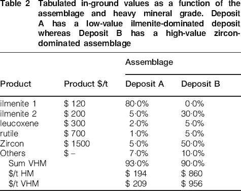
A first-pass, preliminary optimisation of the Resource model may be required to determine the ideal economic cut-off grade (based on HM) for each deposit or deposit style. Ideally, mineral sands should be treated like a polymetallic deposit with the VHM components converted to a nominal equivalent value akin to emulating, say, a Cu equivalent in a porphyry Cu–Au–Ag deposit. Companies have considered this issue, resulting in the concept of converting the VHM to an in ground equivalent dollar value per tonne of Resource. This value is determined by summing the dollar value of each VHM species present within a tonne of HM concentrate at any location throughout the deposit (Table 2). This method allows evaluation of the resource above nominal dollar value cut-offs, including the estimated mining cost per tonne of material, which in turn is dependent on the size and style of the deposit and a number of other material factors.
Tabulated in-ground values as a function of the assemblage and heavy mineral grade. Deposit A has a low-value ilmenite-dominated deposit whereas Deposit B has a high-value zircon-dominated assemblage
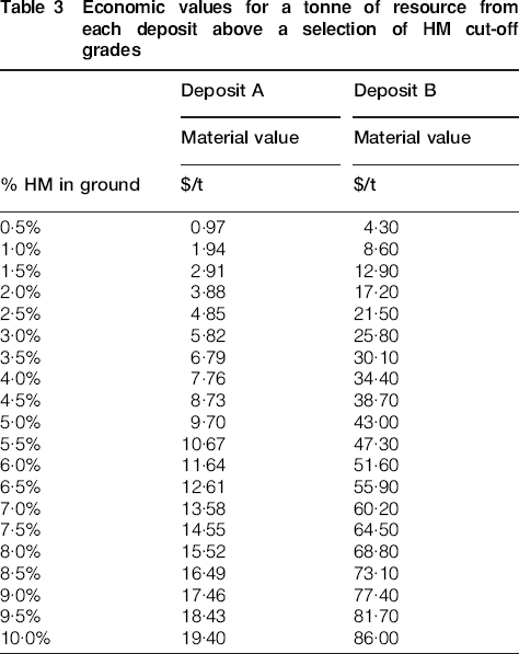
A suitable HM cut-off grade can vary significantly depending on the HM assemblage and this translates to the in ground material value (Table 3). If a production cost of $10 per tonne of material is adopted, by extrapolation a reasonable HM cut-off grade for Deposit A would be five per cent, but only about one per cent for Deposit B. This can be incorporated into geological models such that the assemblage is converted to an ‘in ground’ $/t of material equivalent for a particular pricing scenario. The practitioner can then report a Resource based on the $/t cut-off that is appropriate given the projected production cost. This has a decided advantage in reporting Resource estimates for HM deposits where the assemblage is variable within a deposit. It precludes the risk of including low-value assemblage material if a low HM cut-off is used and conversely compensates for the risk of excluding high-value assemblage material from a Resource estimate if a higher HM cut-off grade is used. While this approach is not widely used in the mineral sands industry, the methodology has the ability to provide an appropriate cut-off value.
Economic values for a tonne of resource from each deposit above a selection of HM cut-off grades
Other considerations need to be taken into account such as expected HM recovery and the amount of overlying waste material, which is further discussed below. For large, low-grade dunal deposits, the cut-off value can be pushed down as the mining costs tend to be reduced for large-tonnage, bulk earth-moving methods due to economies of scale. For narrow, deeply buried and higher-grade deposits where the mining method may require more flexibility and selection, a higher cut-off value may be required.
Consideration of depth of burial in heavy mineral resource reporting
Historically, a variety of methods have been used to define the limits of mineral sands Mineral Resources to be reported. These include:
A straight HM cut-off with reporting of all material within a Resource block model meeting an HM cut-off criterion. This can result in an overly optimistic Resource estimate and may fail to consider the limitations imposed by overlying waste material. Material that is deeply buried may be uneconomic to mine under reasonable conditions and probably should be excluded from Resource estimates.
Accumulating HM grades down drill holes to a nominal basement (usually the base of mineralisation) and only reporting material within a boundary where the hole average meets the accepted HM cut-off criteria. This method has been used in the past, particularly for large Resources typically suited for dredging. It is also applied in deposits with little or no overlying barren material.
Identification of material that is above a nominal HM cut-off grade but which attracts a prohibitive stripping ratio assists the Resource practitioner to remove the material that ordinarily would be reported in a Resource using the traditional cut-off grade criteria. This fulfils a fundamental criterion for reporting a Mineral Resource under JORC guidelines whereby reported Resources must have reasonable prospects for eventual economic extraction.
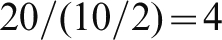
This can be achieved through the use of a factor that considers the average HM grade for an interval divided by the ratio of overburden thickness (sub cut-off-grade material) to mineralisation vertical thickness. Areas of the Resource where the vertical accumulation of HM Resources within the deposit is likely to be of sufficient value to justify the removal of overlying waste material are highlighted for Resource practitioners.
A factor or indicator value can be determined for each vertical column of cells in a Resource model or for a drill hole. The average HM grade of the mineralised interval (above an HM cut-off grade) is divided by the ratio of the thickness of the overlying non-mineralised material versus the mineralised interval.
For example, if we consider the following drill hole:
a cut-off grade of 4% HM
0–10 m down hole interval: 10 m of sub 4% material
10–12 m down hole interval: 2 m of greater than or equal to 4% material at an average grade of 20% HM
the indicator factor would be:
The cut-off values for HM and the indicator value need to be carefully considered in conjunction with factors such as the assemblage value and the cost of waste removal. Lower cut-offs would be adopted where the assemblage value is higher and where economies of scale lead to reduced overburden removal costs (in a large-scale mining operation).
The selection of a suitable indicator cut-off is guided by the operational parameters likely to be employed for a given orebody and the experience of the Competent Person carrying out the Resource estimation. Based on investigations into numerous styles of orebodies and HM assemblage, a range of indicator cut-off values between 0·5 and 1·0 are generally adequate to provide a guide to mineralisation for which there are reasonable prospects for eventual economic extraction.
For the previously described drill hole example, the indicator factor of 4 would suggest that 2 m at 20% HM under 10 m of sub cut-off-grade material could be economic given a cut-off factor of 1.
For a scenario where the average grades of the interval were lower:
a cut-off grade of 4% HM
10 m of sub 4% material
2 m of greater than or equal to 4% material at an average grade of 4% HM
The indicator factor would be:

The indicator factor of 0·8 is below an accepted cut-off factor of 1, thereby excluding the hole/column of cells from being reported as part of the Resource.
Resource reporting: Bulk density
The allocation of bulk density values in mineral sands resources requires due consideration. Some practitioners adopt a universal bulk density or a formula derived from historical literature and often these will not be truly representative of the material being reported. The bulk density applied to a Resource estimate must take into consideration the composition of the material being reported and be supported by physical test work. For example, the bulk density of the material will increase as clay content increases and fills the voids between quartz grains or if the portion of denser HM grains increases. Methods to test the density of HM-bearing material may include nuclear densometric testing or analysis of physical samples.
Whichever method is selected it should be supported by adequate bulk density test work, both in terms of the total numbers of samples tested and the representative sampling of key geological domains within the Resource. Sonic drilling has proven particularly useful in providing suitable samples for bulk density analysis of deeply buried deposits.
Conclusion
Resource estimation for mineral sands follows standard estimation principles as applied to commodities throughout the Mineral Resource sector. However, some aspects of mineral sands require a slightly different approach with particular emphasis on the geometallurgical characterisation. At all stages of evaluation of a deposit the geological model underpinning the interpretation must be tested against the available logging, assay and mineralogy data. This data should confirm the interpreted depositional setting and any domains interpreted based on post depositional processes which may impact on the extraction, processing or saleability of the VHM present. In complex deposits this may lead to many generations of infill drilling and subsequent composite mineralogy samples as a detailed understanding of the deposit is developed as more data is obtained.
More so than for some commodities, it is imperative that resource estimation for mineral sands deposits is undertaken or supervised by someone with sufficient experience in the field. There have been many examples of failed or poorly executed mineral sands projects due to failure to consider the intricacies of mineral sand resource estimation and evaluation.