
Abstract
Modern salt lakes are complex systems which are exploited for a variety of minerals, including solid and dissolved phases (brines). Phases commonly exploited include lithium, potassium and boron minerals, mainly from brines, and solid minerals including halite and gypsum. Resource estimation and successful exploitation of either solid minerals or brines require good understanding of the complex interactions within these systems. This includes careful definition of climate, geology, hydrogeology (hydrology), fluid flow dynamics and lastly chemical ion concentrations. Therefore estimation involves multidisciplinary team work. Brines are mobile resources which change through time, sometimes seasonally, so estimators must understand the climatic, hydrological and geological factors governing flows of both water and salts into and out of the system. Commercial extraction of brines involves brine collection (usually by pumping from wells) at rates that make the extraction economic, so brine resources should include only extractable brines, which are those in accessible aquifers available for pumping. Estimators must take into account potential limits on sustainable extraction rates when assessing the prospects for eventual economic extraction to determine whether a resource is present. Drilling on salt lakes can present significant challenges in safe access, and in recovery of uncontaminated samples of host rocks, which are often unconsolidated, and of brines. The merits of various methods of drilling and sampling are discussed. We recommend a combination of different sampling methods and the use of downhole geophysics to assist in detailed geological interpretation. Well-designed pump testing will provide hydrogeological parameters and enable derivation of the specific yields of all targeted aquifers, which are required to estimate total extractable brine resources. Reliable repeatable chemical analyses of brine samples are hard to achieve, and filtering, minimising storage times, and the choice of a reliable laboratory experienced in brine analyses will all assist in this objective. Stringent quality control is required, and this should include check analyses at one or more independent laboratories. Resampling of the same sample sites will measure seasonal and other fluctuations. Resource reporting must include discussion of all material factors and assumptions, and include discussion of limiting extraction rates, and risks to the sustainable extraction of the resource, which may include climatic risks and risk from neighbouring production. All resources need to have reasonable prospects for economic extraction, so the estimator must be familiar with potential exploitation methods (which include dredging or conventional mining for solid minerals, and for brines pumping from wells, brine recovery via ditches, evaporation and chemical separation) and the factors that affect the cost or feasibility of these methods. The potential for extraction to affect the remaining resource (e.g. by brine pressure reduction, increasingly dilute inflows into a brine resource, dissolution or enhanced crystallisation of solid minerals) must be considered. Resource classification must take into account the definitions of the higher confidence (Indicated and Measured) resources to be able to support mine planning, and we consider these classifications require a hydrological model, based on at least preliminary field testing for indicated, and a geological model and knowledge of chemistry across the resource volume.
Introduction
Minerals commercially recovered from evaporate/brine systems include salt, gypsum, potash, lithium and boron. Evaporite/brine systems are complex dynamic systems which truly demonstrate the principles of quantum physics, that any attempt at observation, including physical sampling, can affect the system we are trying to observe. The interactions between the solid phases (evaporite crystals, other minerals including clays), the liquid phase (brines at varying levels of concentration, and sometimes inflows of fresh water), and free void space involve chemistry and hydrology, which in term are controlled by the climate, geology and mineralogy of the system. This complicates both resource estimation and the potential for successful exploitation of these systems. Despite this, profitable exploitation is common.
This paper focuses on brines and evaporite/brine systems, although some of the aspects of resource estimation discussed here may also affect ‘dry’ or fossil evaporite systems. Dry evaporite systems include the important potash deposits of the Devonian Prairie Evaporite Formation in Saskatchewan, and the halite deposits of the Zechstein Basin in Europe, which have been exploited over hundreds of years. We define evaporite/brine systems to include those where the target minerals may be in the crystalline or dissolved form, but where crystalline evaporates are exploited, the interaction between the two forms materially affects both the resource and its exploitation.
Figure 1 shows locations of the evaporite and evaporite brine systems mentioned in this paper.
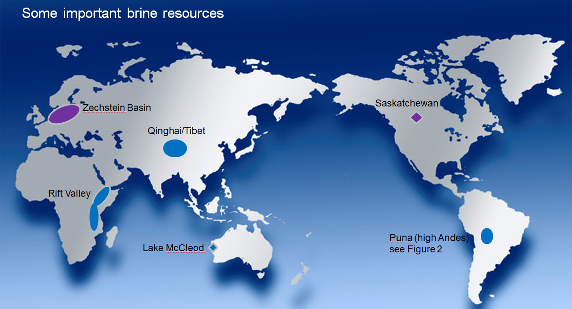
Selected economically important evaporite/brine systems (NB Zechstein and Saskatchewan are fossil systems)
Most recent western world attention has been focused on the salar systems of the high Andean Altiplano-Puna, which crosses the borders of Argentina, Bolivia and Chile (Fig. 2), as the lithium content of these brines has been the focus of attention by a number of companies, which have reported resource estimates. Another important high altitude inland system is located in central Asia, covering parts of Qinghai and Tibet in China, which is exploited primarily for salt and potash. Lakes in the Rift Valley of East Africa have also been exploited for a variety of evaporites, while the Dead Sea, on the same rift system, is an important source of potash. Coastal systems, or sabkhas, have received less attention in terms of resource reporting, but we refer to one well documented coastal system, that of Lake MacLeod in WA. Brines in this lake have been exploited for salt, while solid gypsum has also been extracted, and this system serves as an example of a contrasting style of evaporite/brine system.
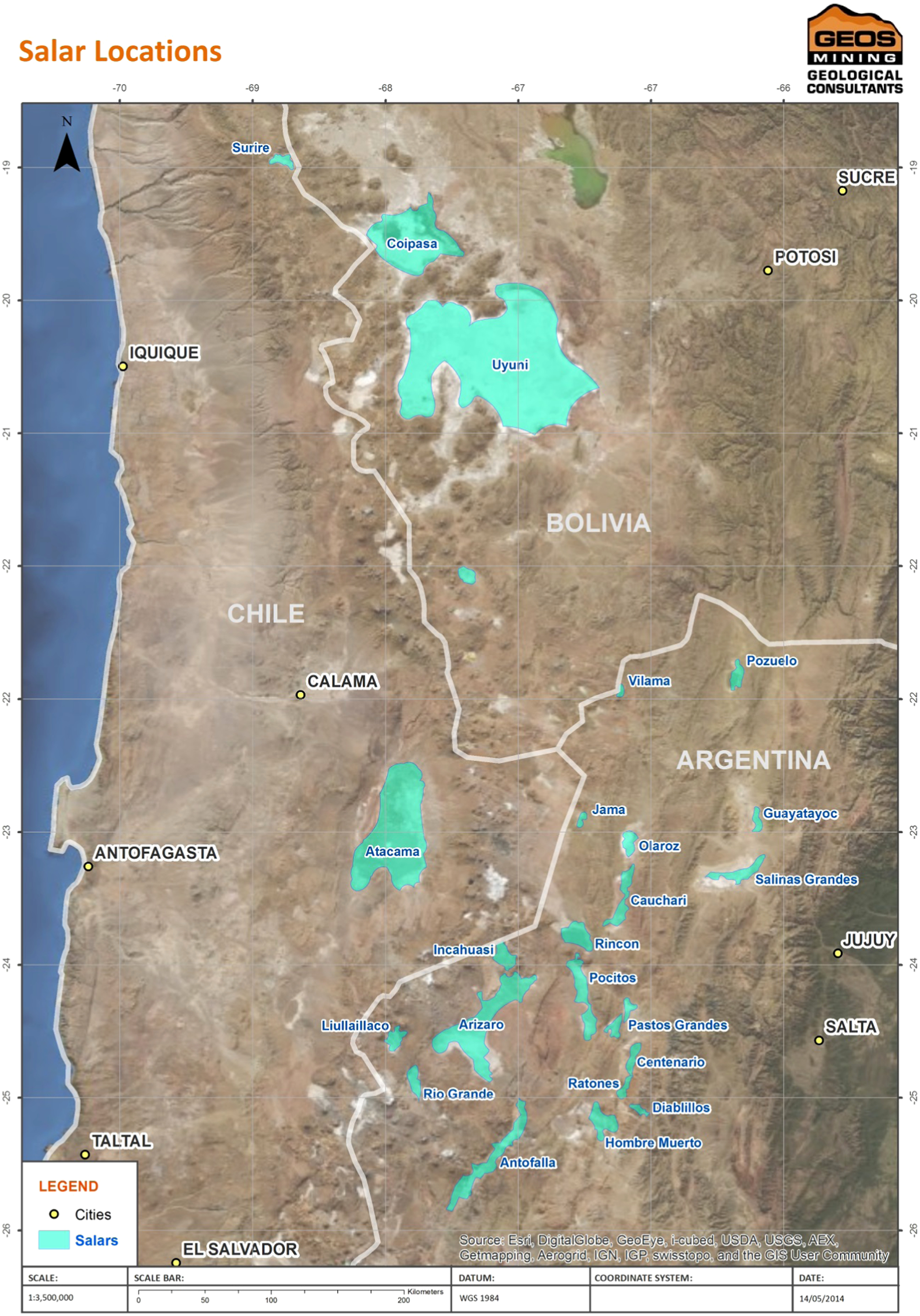
Salars of the high Andes
Evaporite/brine systems
Modern surface evaporite/brine systems occur in arid environments, and can be broadly divided into inland systems (salars or salinas), where the soluble mineral content is derived from the surrounding surface and subsurface lithologies, and coastal systems (sabkhas), where the soluble mineral content is predominantly or completely derived from sea water. The Dead Sea system is an interesting example of a mixed source system, where the salt content is derived from the interaction of seawater filling the late Neogene Sedom lagoon with the Cretaceous carbonate rocks exposed in the basin-bounding escarpments (Gavrielli and Stein, 2006).
Subsurface systems include brines which have migrated down from surface evaporite systems and systems where groundwaters have come into contact with buried fossil evaporites. Our focus in this paper is on surface systems, but some conclusions may also be applicable to subsurface systems.
A typical system involves an inflow of fresh or dilute water, usually from rainfall, but often includes inflow from intermittent creeks, or in coastal systems an inflow of seawater. Most inflows are at surface but some inflows are from groundwater, as is the case of many sabkha systems where seawater seeps in to a basin through dunes or coastal limestone barriers. At Lake MacLeod, brine in the basin is recharged largely by seepage of seawater through a barrier of permeable Tertiary limestone with some Holocene aeolian dunes. Seawater percolation is driven by gravity, as the lake surface is 3 m below sea level.
Basin systems may be closed, where water is lost from the system only by evaporation, or open systems, where some brines may escape through gradual seepage or periodic overflows (Fig. 3). Salar de Atacama is an example of a closed basin (Orris, 2011) while Lake MacLeod is an example of an open basin (Logan, 1987). Free-flow basins have open access to larger water bodies, usually oceans, by a restricted passage often over a shallow sill, but modern examples of these (such as Hamelin Pool, Shark Bay, WA) are not often of commercial interest, as brine concentrations are usually limited.
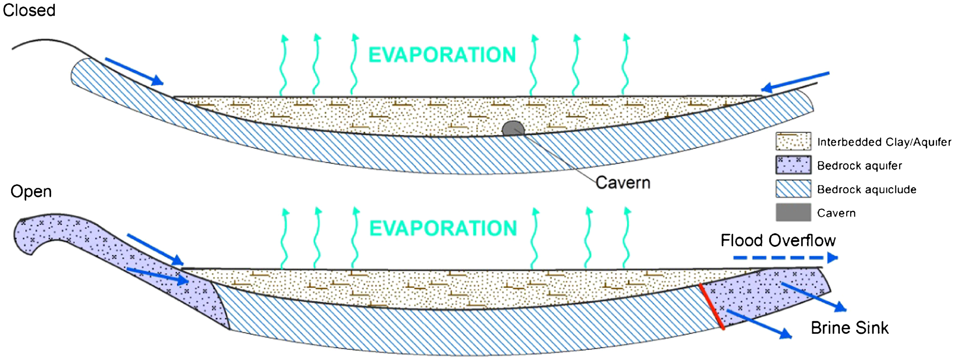
Simplified examples of open and closed basin systems
As water evaporates from any basin system, increasingly saline brine is produced. Most commercial exploitation of surface evaporite systems are confined to climates where the evaporation from free water surfaces exceeds 2 m per annum, and in some areas may reach 8mpa. Evaporation may also occur from groundwater where the water table is less than 1·5 m below surface (Logan, 1987), and this biases the results of near surface brine samples. In many examples the lakes will flood seasonally or periodically, and evaporation will be more rapid while the brines are exposed at surface. Salt concentrations in samples from brines close to the lake surface may therefore not represent the bulk of the underlying brine volume, and this has been confirmed to our knowledge by comparison of drill and surface sample results in at least two Argentinian salars.
As evaporation proceeds, brine density increases and crystallisation commences with the least soluble dissolved minerals. Evaporating seawater leads to the crystallisation of the mineral series in the order first demonstrated by Usiglio in 1849, i.e. carbonate, gypsum, halite, and the bitterns salts (mainly potash and magnesium salts). The more soluble salts, including potassium, lithium and boron, will usually only crystallise in closed basins, when they form a minor proportion of the total volume, and hence in modern systems these metals are usually exploited from brines. Elements such as lithium and boron are concentrated in salars in areas of recent volcanism, such as the Puna – Altiplano areas of Chile, Argentina and Bolivia (Fig. 3).
Evaporation in continental basins leads to a very wide range of minerals and brine compositions, due to factors including regional setting and tectonics, major element ratios of inflows (Hardie and Eugster, 1970), pH (Clarke 2014), biological activity (De Deckker, 1983) and minor element composition. Minor changes can determine whether a mineral is precipitated or not, and precipitation of one mineral changes the composition of the remaining brine, determining the next phases to be precipitated.
Newly crystallised minerals usually form an extremely porous unconsolidated crystal mush, and these form potentially productive aquifers, but increasing maturity leads to solid layers of gypsum and halite, which often have low porosity and permeability. Periodic inflows of clastic sediment in many basins increase the variety of aquifers and aquicludes. Salars where clastic sediments are dominant are termed immature (Houston et al., 2011). Any inflows of fresh water or dilute brines may lead to dissolution of previously crystallised evaporites, leading to caverns, which can have a major effect on brine volumes and brine flows within the basin.
Unconsolidated crystals and clastic sediments, together with the potential for cavern formation within more solid strata, lead to significant safety hazards in operating on salt lakes, and this creates major problems with safely collecting representative samples from all parts of many recent salt lakes. Often light weight equipment must be used, or extensive earthworks may be required to build trafficable roads on the salar surface.
Brines within an aquifer system are not of uniform composition. The composition at any point within a basin is affected by dilution from any inflow, surface evaporation, stratification of brine layers of different density, and local interaction with solid evaporites and other host rocks. In addition, many basins include brines of different compositions, and possibly different ages and origins, trapped in separate aquifers.
Complications in estimation of brine systems arise due to:
seasonal and other climatic effects
chemical interactions between solid salts and brines
interactions with non evaporite minerals, clays and clastic materials
sampling and working in unconsolidated materials.
Table 1 compares the characteristics of some of the major deposits referred to in this paper.
Characteristics of selected major evaporite brine systems
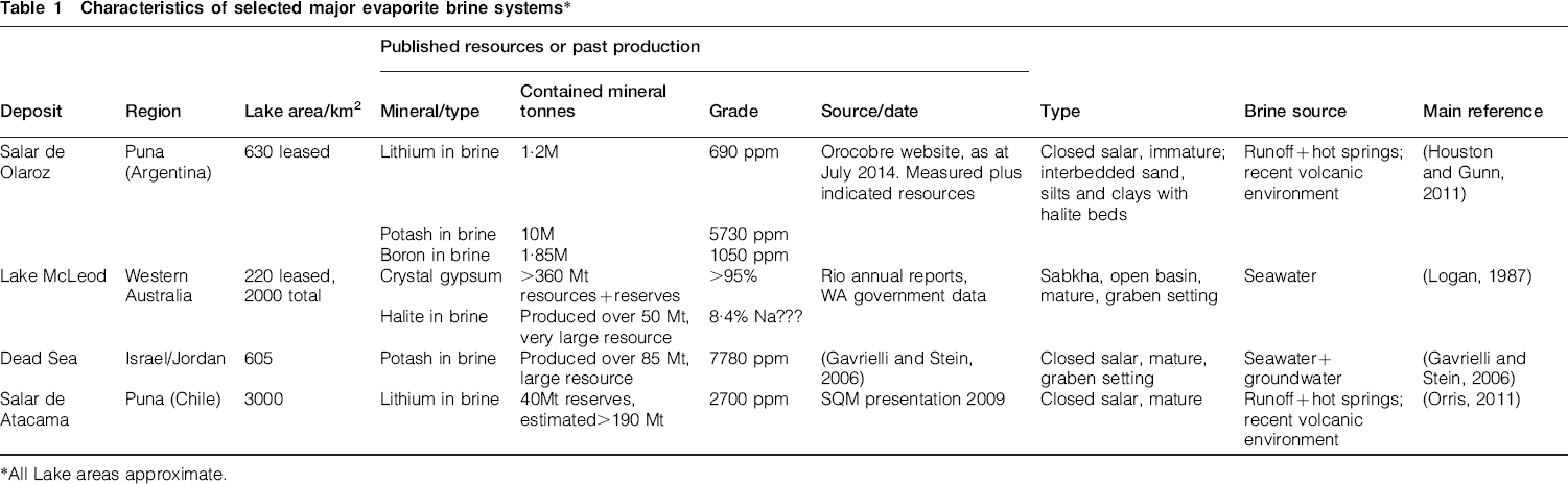
All Lake areas approximate.
Resource classification and reporting
All major CRISCO resource reporting codes (JORC, SAMREC and CIM definitions) confine their application to solid minerals, so do not officially cover brines. Houston et al. (2011) raised the need for new standards for estimating brine deposits. The Ontario Securities Commission issued Staff Notice 43-704 (2011) on standards of disclosure for mineral projects, confirming that NI 43-101 (the Canadian standard for public reporting on mineral projects) should apply to brine projects. CIM then issued best practice guidelines for resource and reserve definition for lithium brines (Hains, 2012), which we commend as valuable reading for any competent person estimating any brine resources. Hains notes that NI 43-101 and the CIM definitions apply to solid minerals, and advises that public reports relating to brine resources ‘should strive to provide a level of clarity and technical detail meeting the spirit and intent of NI 43-101’. We concur with this advice, and suggest that reports and classification of brine resources are stated to be compliant with the spirit and intent of the relevant reporting code.
We note that, despite the efforts of the Canadian authorities, their lead has to our knowledge not been followed by other national standards. No standard that we are aware of has yet explicitly addressed the potential time-dependant variability of the systems, nor the potential that economic reserves could differ for different extraction rates.
The recent JORC 2012 update (Joint Ore Reserve Committee, 2012) mandates the attachment of a technical checklist (referred to as ‘JORC Table 1’) to public announcements of resources which are new or materially changed, unless the project is not a significant project for that company. The danger of this checklist approach is that this may be considered to cover all material items that are required for reporting. Being designed for solid minerals, JORC Table 1 does not include all items significant for brines, or for crystalline evaporites in brine/evaporite systems. Recent guidance from the JORC Committee (Hunt 2014, presentation on 6/6/2014) is that although no JORC Table 1 heading should be omitted, additional headings may be included, and this is strongly recommended when reporting on brine resources.
The dynamic evaporite/brine systems pose special problems in classification of resource confidence, into inferred, indicated and measured resource categories. We refer here to the JORC code and Australian practice but this discussion is also relevant to the sister CRISCO codes which all have similar classification definitions. From the JORC definitions of inferred, indicated and measured resources, we can see that:
Inferred Resources must be at least ‘more likely than not’ (JORC, 2012) to be exploited, so a minimum 50% probability is expected for any part of the resource to be minable
Indicated Resources must be known with sufficient confidence ‘to allow the application of the modifying factors in sufficient detail to support mine planning’ (‘modifying factors’ are defined in the JORC code to be all factors that impact whether a resource may be economically mined). This is generally accepted by industry as implying it should be meaningful to schedule the resource on an annual basis
Measured Resources should be capable of supporting ‘detailed mine planning and final evaluation of economic viability’, which is usually interpreted to mean mine scheduling on a quarterly basis and acceptable as an input to a definitive feasibility study.
A common industry guideline (Glacken and Trueman, 2014) is that the estimators should aim that Indicated Resources have an error of ±15% at 90% confidence for annual production volumes, while for Measured Resources the same confidence limits apply to quarterly production volumes. Glacken and Trueman also note that different companies have a greater or lesser risk appetite and therefore may vary these confidence limits. We would note also that different commodities and types of deposit may necessitate different confidence limits.
In the case of brine exploitation, we anticipate that grades will usually vary less between adjacent production periods than for traditional metal deposits, but there are greater potential risks to the effective life of the deposit. Hence the industry guidelines above for Indicated and Measured Resources are not directly applicable.
The requirement that Indicated Resources ‘allow the application of the modifying factors’ does, in our opinion, mean that a hydrological model must have been completed for the deposit, in sufficient detail to give the estimator confidence that the stated resource can be extracted, within a reasonable error limit. We would tentatively suggest a 90% confidence of less than 25% error in the total recoverable metal to be a reasonable requirement for preliminary mine economic planning. Therefore there must be confidence in both sustainable metal grade and extractable brine volume. This must mean at least preliminary pump tests have been completed to demonstrate the feasibility of extraction. We agree with Houston (Houston et al., 2011) that resource volumes should be based on specific yield. The metal content of the brine should have been tested at different times and locations across the brine host, and the system should be sufficiently well understood to have confidence in the likely interactions between brine, any inflows, and host rock.
Measured resources imply valid short term production estimates, which require detailed geological and hydrogeological models. Sufficient pump tests to determine hydrogeological parameters and chemistry for all portions of the production field, and knowledge of seasonal or occasional climatic effects (flood events, etc.) are therefore required, in addition to a high level of resource drilling across the field to enable strong definition of geological, chemistry and resource continuity.
We have heard of one case where a single point of observation (a twinned well) was the basis for a description of a brine resource as a Measured Resource; we strongly disagree with this approach. We consider that the coverage of data points should be adequate to have confirmed the chemistry of the brine across the salar (or the relevant portion of this to be included in resources). Data spacing for any resource classification will depend on the parameter variation between initial data points. In some mature salars, the chemistry and permeability will be relatively uniform, certainly across the central portion of the salar, but sufficient data must be obtained to demonstrate this.
Prospects for economic exploitation
Exploitation methods
Potential resource estimation must start with a consideration of whether the minerals of economic interest are to be exploited from minerals or brines (the crystallised solid or dissolved salts), or may exist in concentrations of economic interest in both forms. The more soluble minerals (which include lithium, boron and magnesium) are usually or exclusively exploited from brines, while the less soluble gypsum is invariably exploited from crystals.
Potash is exploited from both brines and solid evaporites, with the most common solid phase exploited being the simple chloride, sylvite, but alunite and glaserite (mixed sulphates) have also been exploited. In a brine/evaporite system, acidity may be the most important factor in determining whether potassium concentrates in the brine or is deposited as a sulphate (Clarke, 2014).
Exploitation of solid mineral phases may use a variety of traditional mining techniques, most commonly open cut mining of consolidated materials and dredging of less consolidated minerals. At Lake McLeod dredging was used successfully to exploit the unconsolidated layer of gypsum crystals. Where solid minerals are exploited, the brines are only relevant to resource estimation as they interact with the target minerals. This may happen if brines are drained before or during mining, and are replaced by inflows of more dilute or chemically different waters, which can partially dissolve the solid phases. This possibility should be assessed as part of economic feasibility, and for this reason, it is important to understand the brine chemistry even where only solid evaporites are the target for exploitation. For example at Lake McLeod fresh water sprays were used to lower the salt content of the gypsum, and drainage water had the potential, if not properly managed, to form solution cavities which could impede operations, and ultimately dilute the brines which were being exploited in another part of the lake for salt production.
In addition, in many cases where solid minerals are exploited, the brines are the ultimate source of the solid minerals, which are often still actively depositing. In these cases, detailed understanding of the brines is required to understand and estimate the solid mineral resource.
Solid mineral phases may also be exploited by solution mining, and in this case any brine(s) within the formation to be exploited will interact with and potentially contaminate the fluids pumped out during mining. Therefore resource estimation where solution mining is a potential method of exploitation should include an assessment of the quantity and chemistry of any contained brines.
Exploitation of brines involves:
brine collection (from surface ponds, boreholes or trenches)
pumping
evaporation, usually in purpose built evaporation ponds (Fig. 4)
selective crystallisation, which often includes chemical modification to ensure the desired salts are deposited, and
collection and purification of the final products
product transport and marketing.
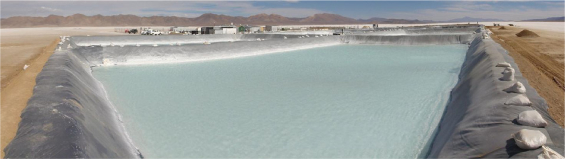
Purpose built evaporation ponds, Salar de Olaroz (from Orocobre Limited, 2012)
Assessment of economic prospects of brine exploitation
To be economically exploited, there must be sufficient brine to justify the required capital expenditure, and all steps involved in exploitation must be technically and economically feasible. In contrast to solid minerals, brines are mobile within the timeframe of a mine life, which adds complexity to resource estimation.
The estimator must assess:
Brine volume available to be extracted. This is not merely an estimation of storage volume, derived from the volume of aquifer and porosity of that aquifer, but more precisely that of specific yield, the potential yield of drainable fluid obtained under gravity flow from the interconnected pore volume (Hains, 2012). Hains states ‘in general only approximately one-third of the total brine volume can be recovered’
The likely maximum rate of brine collection. An individual well can be pumped dry if pumped too hard, and this rate is governed by permeability limiting the rate of recharge. Up to a point closer spaced wells or extraction points will permit higher rates of extraction, but practical and economic considerations will restrict this. Potential extraction rates should be studied in detail during reserve estimation, but the resource estimator should consider recharge rates, and discuss the impact of these on potential extraction rates in the resource report:
The effect of extraction on the resource. In many systems, extraction will draw fresh water into the brine body, and extraction plans must be designed to restrict this dilution to ensure concentrations will not drop prematurely
For example, at Lake MacLeod current brine collection for salt production is at an average rate of 55 m3 per minute (Dampier Salt Limited, 2014), and the operation may be expanded in the future. One of the advantages of this operation is the brine concentration, which is 10 times saltier than seawater. Fortunately the lake is large, and the hydrogeological system is well understood, so the impact of any increased extraction on brine concentration can be modelled, as in this system increasing extraction could potentially lead to increased inflows of sea water and lower density brines
In addition, many salars, particularly in Latin America, are not under single mineral title/concession. Pumping by a neighbour will inevitably affect mine life and extraction rates in adjacent tenements, as brines do not respect tenement boundaries in their migration. Resource risk due to neighbouring extraction operations should be discussed in the resource report. Note that the converse is not true, as any brine currently not within the tenement(s) being assessed is not owned by the tenement holder, so our opinion is that brines currently outside the tenement boundary cannot be included in any resource, despite the fact that these brines may later migrate into the tenement
Minimum extractable grade (cut-off grade). Where metal concentrations in brines are expected to decrease with time of extraction, the estimator must only include in the resource brine volumes that are anticipated to be extractable at above a minimum grade that is likely to be economic to process. Any discrete aquifers containing brines which are on average too low grade, or of too unfavourable chemistry, for likely economic extraction must not be included in a resource. The potential for brine mixing during extraction must always be assessed prior to application of a cut-off grade
Climate will govern the evaporation rate and hence speed and economics of evaporation in open ponds. Where open evaporation is likely to be used in the extraction, climate should be discussed in the resource report. Storms and/or flooding may impact on the brines themselves, and also interrupt production by dilution of evaporation ponds, and these risks should be identified and where possible quantified using meteorological records
Brine chemistry, including all soluble salts in the brine, must be assessed, not simply the concentration of the desired elements, as this will control the complexity and hence cost of the selective crystallisation process
Any other factors that may impact on the ability to extract or economics of extraction. All the modifying factors for reserves should be considered. Examples include government policies and permitting, environmental and social factors, market for the commodity, infrastructure availability and costs.
The JORC 2012 requirement that any resource should more likely than not be eventually economically extracted is quite a stringent test to pass. Where the competent person can see that all the above factors are similar to or more favourable than current viable operations, then in our opinion a resource is present. Where one or more factors are significantly different and less favourable than current operations, then further studies should be carried out before the competent person should publically sign off on any resource. These studies may be simple, almost back of the envelope calculations (e.g. infrastructure cost will be large, but extractable brine volume is also large, so estimated infrastructure costs are likely to add only a few cents per pound to the cost of the lithium carbonate produced). Alternatively studies may need to be more detailed, and may extend to a full scoping study to demonstrate likely costs of production. In most cases the competent person should use experts in fields other than their own expertise to carry out some or all of the necessary work, but the competent person must take responsibility for the quality of the work done. In all cases, the competent person should be careful to record the reasons, information and studies used in making the decision that a resource is present.
Sampling
Drilling methods
The primary requirements are to identify host geology and sediment formations, and to sample available brines from identified aquifers. Surface brine sampling from near surface pits, and inflow points (streams and or springs) are often not representative of the whole brine system, hence there is a need to identify potential aquifers (surficial and at depth), and sample all brines within these aquifer(s) throughout the area of interest. Access to samples of deeper brines throughout the area of interest is only achieved by significant drilling and hydrogeological studies (pumping tests). The host formations of the brine system are often unconsolidated and may contain solid hard material as interbedded layers, lenses or partial interfingering units, which often create drilling problems.
Typically there is very low recovery with diamond core drilling in near surface and deeper aquifer formations which are often unconsolidated or semi-consolidated. Sonic drilling techniques, or dual/triple tube reverse circulation (RC) drilling techniques, have been used successfully to identify formations and sample brines in shallower holes (<100 m). Sonic drilling methods can obtain relatively undisturbed samples of saturated materials. Dual tube wire line reverse circulation drilling methods can also achieve good sediment sampling, and both methods can recover representative samples of brine from targeted shallow aquifer horizons during drilling.
A combination of Sonic and RC drilling methods are recommended due to the strengths and characteristics of these two drilling methods. Sonic drilling recovered core is far better for geological information collection within saturated and unconsolidated sediments. Reverse circulation drilling is usually faster and cheaper and is considered better for sampling at greater depths though the recovered sediment is more disturbed. Both drilling methods can use push spilt-spoon samplers to acquire sediment samples ahead of the drill face for density and porosity testwork. Split spoon samplers, of ∼30–40 cm length, are pushed into the sediment ahead of the drill bit to garner a representative relatively undisturbed sample of the sediment yet to be drilled. Such push samplers obtain a good sample in semi-unconsolidated clay rich and mixed sand clay horizons. However they can be less than effective in saturated sand units or if encountering hard interlayered beds such as cobble beds or halite.
Drilling is best coupled with down hole geophysical (natural gamma, neutron, sonic, density, and calliper) surveys to identify aquifer physical parameters and assist in geological correlation.
Reverse circulation drilling combined with downhole geophysics will give reasonably reliable geological information at a reasonable cost, while sonic drilling will give undisturbed geological samples and geological information to enable accurate interpretation of the downhole geophysics.
Brine sampling
We agree with Kunasz (2013), that aquicludes such as silt/clay units and solid halite beds/lenses will not contain significant exploitable brine(s), due to low permeability and specific yield, and as such these must be excluded from resources. Hence these units should not be targeted for brine sampling as this is a waste of project time, resources, and money. Prescriptive sampling programmes, such as sampling every 3 m run, can result in ineffective campaigns with delays caused by time spent trying to sample brines from low- or non-yielding silts, clays or solid halite beds.
The occurrence of aquicludes and aquitards, even where thin, must be recorded as understanding their distribution is vital to resource estimation. Therefore, a high standard of onsite geological logging and sampling control is critical.
To reliably sample brine of targeted aquifers within existing or proposed drill holes, there is a strong need for carefully constructed cased extraction wells specifically aimed at sampling the aquifer required. These can be either single aquifer extraction bores or multi-aquifer sampling bores, which require a high level of precision construction. Brine samples obtained by simply drilling a hole and sampling the contained brine can, at best, be described as a mixed brine sample from the entire hole and are indicative only of a drill hole – combined aquifer average content. This can be acceptable for sampling a uniform brine lake system or if interested in a single salt mineral, but not if you are targeting higher grade metal ions within brines from specific aquifer(s).
Collection of brine samples within aquifers at the drill face as the drilling advances is common practice. This is not considered to be as high quality sampling as would be obtained from adequately constructed, properly cemented sampling bores. These bores need to be adequately grouted and sealed, with gravel packed intervals to isolate the targeted aquifers. Such properly constructed ‘piezometer’ bores can be utilised over many years and enable sampling over a longer time period to give a more detailed picture of aquifer/brine variation over time. Early construction of piezometer bores permits repeat sampling of brines to determine changes in chemistry with time, which is essential to understanding the brine system and seasonal and other influences on the system.
Most drilling campaigns, particularly early in exploration, are limited in time period. This limits the methods used to obtain initial brine samples. Methods include the use of slimline high flow down hole submersible pumps, the compressed airlift method, or bailing method of brine sample retrieval from the drill face, with the use of suitable hole packers to limit inflow to the target horizon and well point screens to filter particles.
Retrieval of sample by compressed air lift method has obvious limitations of decreasing effectiveness with increasing depth and size of drill hole (including cavities encountered) and pressure of the air delivered. Inflow leakage due to less than effective drill hole packer systems resulting from partial obstruction or excessive caving of the drill hole wall are obvious potential sources of contamination. There is also potential for injection of drilling fluids and overlying aquifer(s) brine into the currently drilled aquifer by over pressurisation during drilling and or hole ‘cleaning’ activities. The use of limited amounts of non-reactive soluble dyes or fluorescent dyes added to drilling fluid and down hole between the inner rod and outer rod once the packers and well screen have been emplaced can aid in determining whether such contamination is significant. Field staff must ensure the extracted brine is free of dye before being deemed suitable for sampling. A standard rest period is required to allow the brine to infill the ‘purged’ drill hole, equalise to the brine level and settle; recovery of a suitable brine can then take several attempts if contaminated and showing dye or is of high turbidity.
A similar procedure is used in the case of a bailer however the bailer can be used at all depths of the drill hole. Point source bailers and an associated winch mechanism are usually easily obtained and transported, and can be used to extract samples from monitoring bores to test for variations in the brine with time.
Slimline in-hole submersible pumps are able to extract sufficient brine samples from a similarly setup drill hole, however in hypersaline conditions and where there is a high degree of particulate matter or following accidental immersion into settled ‘mud’, pumps can prove prone to malfunction. More expensive inline pumps are available on the open market however these may be difficult to obtain locally.
As shown by the British Geological Survey (BGS 2014), the use of a combination of different sampling methods; down hole samples during drilling, standing monitoring (piezometer) bore purge and sample, as well as routine sampling of fluid influxes (springs, stream inputs, etc.); adds a higher level of reliability and confidence to any resource/reserve estimation than a single sample set alone.
Brine analysis
Once the brine samples have been collected, and the source aquifer(s) is recorded, the brine should be analysed for all contained anions and cations. Brines samples should be filtered through a 0·45 μm membrane filter to remove particulate contaminants (syringe filters are the cheapest option) and placed in a new HDPE plastic bottle which has been rinsed 3 times with small aliquots of the filtered brine sample. The sample is then to be stored in a cool contaminant free place (large insulated cooler boxes are suitable for this in the field, as long as they are kept internally clean). Sampling protocol must be reviewed with the progression of the programme, any change to method recorded, and later discussed by the competent person in any resource classification reporting.
Accurate analyses are not easy to obtain. Sampled brines change with time, will deposit salts in response to temperature changes and sometimes due to interaction with the holding container, and even reabsorb some of those salts and deposit others as conditions change. Such conditions may include temperature, fluid movement (including vibration in transit), light (UV absorption); interaction with any clay/silt particles in the fluid. The interaction between various salt species (and contaminants, e.g. clay) in the brines makes low level accurate analysis problematic and analytical repeatability can be difficult. Creation of a project standard is important, but brine standard samples will also age as will ‘representative samples’ or ‘split’/repeat samples held in secure storage.
In addition many water laboratories are not accustomed to testing samples of highly concentrated brines (Hains, 2012) and this may lead to biased or inaccurate results, so results should be confirmed using different laboratories. Primary considerations in choice of laboratory should be suitability of methods available, accreditation in those methods, experience with brines, speed of transport from site to laboratory, and laboratory turn-around time, with analytical cost a lesser consideration.
Quality control is vital for brine analyses, but duplicate analyses can be materially affected by longer transit times and resultant solution variation and/or by slight differences in analytical approach. Without umpire analyses the competent person is left with a problem in deciding which set of analyses are the more reliable. Brine chemical and charge balance modelling can be a useful quality control check, as long as a complete suite of elements within the brine is analysed. The CP must record the QA/QC sampling, analytical methods used and the evidence or lack of it for limiting the ions and cations analysed for to a specific subset. Round robin testing may assist with identification of more reliable results. Sample security, storage and transport protocols must be adequately recorded, and must be available to be reviewed by the CP for resource estimation.
Once an initial set of reliable analyses have been obtained, regular resampling of designated monitoring sites will measure seasonal and other fluctuations in brine chemistry of the target aquifers. This is essential to understanding the hydrogeology of the brine aquifer system, and for confidence in resource and reserve determinations.
Surveys
Construction of a realistic model requires understanding of the interactive dynamics of the hydrology, geology and brine chemistry of the system. Physically distinct domains are common within these dynamic systems. In volcanically active regions like the Andes, it is common for ignimbrite debris flows to splay into the basin, sealing a portion of the system beneath the flow. In mature basins, a thick solid halite core with limited porosity and brine content is geologically and hydrologically distinct from the surrounding mixed evaporite/clastic sequence. Another common event is a major flood event, depositing extensive clastic sediments within a portion of the basin and introduced fresh diluting (dissolving) waters, which may form caverns in older evaporites.
Geophysical surveys of the brine basin are strongly recommended to determine basin morphology and internal structure. Appropriate geophysical surveys, such as ground based gravity and or 3D seismic, will also enable continuity to be established between data points. Determining of these domains by geophysical surveys can save the cost of needless drilling and sampling of low potential or areas of reduced potential. Geophysical surveys may also enable recognition of sources of contaminates such as travertine or sulphur springs, areas of low salinity inflows and leakage points such as faults, all of which are vital to understanding the system and enabling accurate resource/reserve determinations. Electrical conductivity may be useful to distinguish fresh water from saline water, but is unlikely to materially assist in differentiating relative salinities within many brine systems.
Modelling
Sampling and data alone is insufficient; the data must be assessed and interpreted. The main issue is that brines are within dynamic systems; brines migrate with time, react with the materials around them (especially with the solid evaporite and charged clays), and progressive dissolution and precipitation will alter the pathways the brines travel through as well as the brine chemical character itself. These changes happen naturally, seasonally, with major floods, tectonic changes or volcanic eruptions or other incursions which will impact materially upon the system. Once commercial extraction starts, the whole system alters again to reform a new temporal equilibration; introduction of increased brine extraction capacity will again change the dynamics of the system.
For sustainable extraction of brines we need to consider both brine components, the water balance and salt balance over time. Where solid minerals are of economic interest, it is still important to understand the chemistry of any brines in the system, and any potential changes, whether natural or induced as a result of mining, as any change may dissolve the targeted mineral, or deposit other minerals which can dilute the resource or hinder exploitation. However for solid mineral exploitation, the understanding and modelling of the brine system may be less rigorous than that required for brine exploitation.
Compared to solid metal resources, where we just need to estimate tonnes and grade, for brine exploitation we need:
extractable brine volume = aquifer volume times specific yield (accessible/drainable porosity)
average brine chemistry
permeability which determines brine hydraulic conductivity and transmissivity, to factor how fast the brine can be extracted. In an open system allowance for recharge rate and the chemistry of the recharge must be made, as well as the reactions the recharge will undergo.
The initial framework for any model is an accurate solid geology model. Sufficient drilling, geophysical downhole probe logging and basin surveys are recommended to form the basic data for modelling.
Hard boundaries are appropriate to model the contacts of the basin and basement, but within the basin a good understanding of the sedimentary packages will govern whether hard boundaries are appropriate. For example, clastic sediments may have clearly defined boundaries (e.g. channel sands) or may interfinger with evaporite. Within the basin the most critical units for modelling are the aquifers and any solid evaporites (which may form part of the resource, or may react with the brine).
Basin history will govern whether a stratigraphic (also known as a seam or layer) model or a block model are most suitable. For example, the Lake MacLeod system, with distinct thin stratigraphic units each of 1 to 6 m thick (Logan, 1987) is best modelled as a stratigraphic model, while the deeper and more uniform halite dominated Salar de Rincon (Pavlovic, 2004) is more suited to a block model.
The dry bulk density is not easy to establish for less consolidated sediments, but is critical in establishing resources for solid evaporites. Geophysical data may assist with obtaining an average bulk density. When considering the bulk density from first principles, using the specific gravity of components, the free void space must be considered, as well as the density of the brine and crystal components.
In some systems much of the brine volume can be within caverns (within halite) in the system; these are often best assessed on a probability basis. Seismic surveys may assist with determining near surface cavities, but it can be almost impossible to determine exactly where caverns are at depth, and we rarely have enough data to give a reliable estimate of how many or the extent of caverns. Detailed gravity may assist in determining the overall proportion of cavities, where geological boundaries are well known. Good geological understanding of potential pathways for dilute liquids can help in predicting likelihood of caverns. Porosity of cored samples and permeability measurements from cored samples rarely indicate the extent of cavitation. Hence the porosity and permeability can be understated, or potentially exaggerated if cavities found in one unit are assumed to be typical of the whole system.
While porosity and permeability are important factors in a model, it is the specific yield and hydraulic conductivity which will be the major determining factors in the economics of the brine resource. These can be derived from pumping tests of recognised brine bearing aquifers.
Fluid flow modelling using data from long term hydrogeological pumping tests is crucial to determining specific yield, the parameters of production and hence reserve estimations. Long term (20–40 days or longer) pump test results are used in conjunction with geological data as model inputs. These inputs include climatic data, aquifer geometry, permeability, porosity, groundwater pressures, and brine chemistry. This leads to salt and water balance modelling that integrates rainfall and surface water inputs with evaporation and other outputs/leakage. A 3D model of fluid flow and solute transport that incorporates known variation in fluid density across the salar can then be constructed and attuned to the input data. The final model is usually constructed by specialists in the field of fluid flow modelling using recognised mathematical modelling techniques, commonly finite difference modelling, within software packages, such as USGS Modflow-Surfact version 4 used at Salar de Olaroz (Orocobre Limited, 2012). Rates of extraction and long term effects are able to be quantified and brine production capacity defined over a period of time, demonstrating the prospects for economic extraction for resources, and also giving sufficient hard data to generate economic models and estimate reserves.
Recommendations
A multi-disciplinary team approach is mandatory for any resource estimation in these systems. A thorough understanding of geology forms the framework for any resource, but in these systems geology alone is not enough.
Climate monitoring, including rainfall and records of any surface inflows into the basin, is required for any sustainable extraction of evaporites or brines from salars or sabkhas, and this data should be collected during exploration.
Geophysics (both downhole and regional surveys) assists in understanding geology and in reducing unnecessary drilling. Geophysical surveys can model the basin form, internal structure and any underlying structure early in an exploration program to determine the likely basin type and areas of potential discharge.
In many systems a combination of sonic and reverse circulation drilling with downhole geophysics will produce reliable geological data in a cost effective manner.
Brine sampling adds significant time to drilling, and the emphasis should be on sample quality rather than speed of sampling. Brine samples should be collected from aquifers, not on a regular downhole distance, as aquitards such as silt and clay layers will not yield extractable brines.
Modelling starts with a reliable model of basin geology, with particular attention paid to evaporite targets, aquifers and aquitard units. Resource models for brines must be limited to defined aquifers. For this reason, specific yield should be tested early in a program, by construction of piezometer holes and preliminary pump testing. Hydrophysical measurements on core (or split spoon) samples are useful checks but do not substitute for field measurement of parameters.
To ensure accurate brine chemistry, select suitable laboratories and institute rigorous quality control, which should include some round robin testing.
Resampling of brines is required to determine variation with time. A single set of samples from one moment in time is unlikely to give high confidence in the whole fluid flow cycle and reliability of dataset. Multiple repeat periods and different methods of brine sampling are desirable to increase confidence in results.
A fluid flow model based on the measured hydrogeological parameters, including consideration of brine chemistry, can demonstrate stability with time and feasibility of extraction.
There should be explicit discussion of limiting extraction rates in any resource report. Climatic (e.g. flood events) and other risks should also be identified and discussed.
We recommend the use of agreed or legislated buffer zones between neighbouring tenements in a single salar, with no wells to be developed in the buffer zone without the explicit agreement of the neighbouring tenement holder. This would reduce the risk of extraction interaction, and give more security to investors and developers that well life would not be curtailed by the actions of neighbouring producers. Where adequate buffers do not exist, and the salar is split between different owners, the resource report should discuss risks to the resource from aggressive extraction by neighbours.
Conclusions
Modern evaporite/brine systems are complex and dynamic, and there are significant hurdles in their evaluation. A skilled multidisciplinary team with a well-designed exploration program using modern techniques can overcome these hurdles, and this work will form the basis of reliable resource estimation. As there are so many more parameters to estimate when compared to traditional deposits, it will take longer to define resources, and much effort to classify resources at a higher level than inferred. We consider that climatic data, significant hydrogeological studies including long term pumping tests, resampling of brines over time and a comprehensive fluid flow model of the basin would usually be required to generate indicated or measured brine resources.
Footnotes
Acknowledgements
Thanks to Peter Rogers for preparing the diagrams for this paper, and thanks to all the Geos Mining team for stimulating discussions on resources and geology.