
Abstract
Rehabilitation at a silica sand mine on the Swan Coastal Plain of Western Australia, where the post-mine landscape consists of small pit lakes (dredge ponds) with surrounding battered slopes, and where a range of ecological restoration techniques have been applied, was monitored for several years to gauge success or otherwise of these techniques. Results clearly showed the benefits of using fresh topsoil for restoration over topsoil that has been stockpiled for several years. Most topsoil used in restoration was from seasonal wetlands and consequently restoration was most successful in the riparian zone from the edge of pit lakes to ∼2 m vertically above the water table. Rehabilitated areas above this level remained poor in plant species and cover with remedial actions largely unsuccessful. We believe that matching topsoil to site and development of topographic profiles similar to natural wetlands of the region are the keys to optimising rehabilitation success around pit lakes formed by sand mining in areas with shallow groundwater.
Introduction
Mining of sands containing heavy minerals and/or other mineral resources often leaves a legacy of dredge ponds, relatively shallow and small freshwater pit lakes (Lubke et al., 1996). This is because groundwater may be relatively close to the surface in sand dune and sand plain systems and dredging is usually the preferred method to remove ore containing sands occurring below the water table. Dredging of sand involves creating ponds followed by the removal of sand from the bottom of ponds through suction or bucket. Following mining, overburden and sometimes residue can be used to fill ponds, but insufficient volumes of waste material usually mean that some permanent ponds will be maintained. Waste material is typically used for reconstructing landforms and to batten down the edges of the mined area. Dredge ponds are a type of mine pit lake, a more general term used to describe post-mining landscapes which fill with water to varying depths (McCullough and van Etten, 2011).
The challenge for restoration of such pit lake landscapes is to create a sustainable and productive aquatic ecosystem within the pit lakes and acceptable levels of vegetation cover and species diversity in the fringing, riparian and upland communities on the surrounding slopes (Lubke et al., 1996; van Etten et al., 2011). Depending on the locality and local circumstances, it may be important for restoration to resemble or approach natural ecosystem(s) previously existing at or nearby the site, and/or to contribute to regional scale biodiversity conservation. An often ignored element of pit lake restoration is the transitional zone between permanent water and truly terrestrial environment, the fringing and riparian vegetation. Fringing vegetation here refers to plants growing at waters’ edge, either emerging from permanent water or experiencing regular flooding, whereas riparian vegetation refers to plants growing above the fringing zone which can access lake water through tapping into shallow groundwater and/or irregular flooding episodes. There are many examples of pit lake margins where little or no vegetation cover has been re-established (Lund and McCullough, 2011), although there are exceptions (Wilcox and Whillans, 1999). The riparian and fringing vegetation has numerous potential values and benefits to pit lake ecology (such as habitat, organic matter and nutrient input, bank stability, etc) and aesthetics (van Etten, 2011).
Harvesting and then spreading topsoil over recreated landforms (topsoiling) has become a widely used and generally successful technique for restoring post-mining environments (van der Valk and Pederson, 1989; Cooke and Johnson, 2002). Some researchers report high proportions of plant species (of reference or target ecosystems) being restored via a returned topsoil seed bank following mining; for example:
Koch (2007) reports ∼70% of species are returned via topsoil for jarrah forest in southwest Australia (following bauxite mining)
Holmes (2001) found 60% species returned for fynbos shrubland in South Africa (kaolin mine)
Parrotta and Knowles (2001) report 40% species of tropical rainforest species return in Amazonian Brazil (bauxite)
Hall et al. (2010) found 60–70% species recovery for an oak–hickory forest in the Appalachian Mountains, USA (coal).
Bellairs and Bell's (1993) study of rehabilitation at a sand mine on the Swan Coastal Plain north of Perth (Eneabba), where only terrestrial landforms (dunes) were recreated, concluded that applied topsoil was responsible for the majority (63–78%) of plant species emerging from rehabilitation. In contrast, Herath et al. (2009) found only between 29 and 48% of species in rehabilitation originated from topsoil in the same mining area. Both studies from Eneabba demonstrated the importance of brushing and mulching to increase species diversity of rehabilitation given that relatively large numbers of species in the heathlands of this area maintain an aerial (plant) seed store as opposed to a soil seed store. In addition to contributing to post-mining rehabilitation, topsoil has been used to successfully restore degraded land, including denuded wetland margins (Nishihiro et al., 2006).
Ongoing research and practice has ensured a continued refinement of the topsoiling approach to restoration. Although accepted best practice is still evolving, and it is likely that some key parameters and decisions will depend on ecosystem type, degree of modification and so forth, there is general agreement that restoration outcomes improve with:
minimal topsoil storage time with direct return recommended where feasible (Ward et al., 1996; Rokich et al., 2000; Milton, 2001)
relatively shallow depth of topsoil collection, storage and spread (Grant et al., 1996; Redente et al., 1997; Rokich et al., 2000)
sieving and concentration of seed in topsoil before spreading (Koch, 2007).
In this paper, we present and evaluate the results of several years of monitoring rehabilitation of pit lake margins and their surrounding slopes which were created following sand mining for silica and heavy minerals at a mine site on the Swan Coastal Plain south of Perth, WA, Australia. At this site, rehabilitation has been progressively implemented in stages over a number of years, with topsoiling used as the main method to return plant species cover and diversity. Distinct zones of rehabilitation with different ages since topsoil application (varying from 1 to 8 years post-rehabilitation at time of monitoring) and different topsoil storage times (from topsoil stored for several years before application to direct return of topsoil) occur around the lakes. Comparisons of these zones in terms of plant density and diversity are used here to make inferences about the likely effects of topsoil type and treatments to meet the short term rehabilitation objective for the mine site of returning native plant cover. In addition, these and other monitoring results are used to gauge whether longer term restoration objectives of re-establishing ecosystem attributes similar to that found in the area before mining are being fulfilled (or are at least on the right trajectory). Comparisons to natural wetlands in the surrounding lands are used here to aid in this evaluation. It is clear from observations that rehabilitation outcomes have been highly variable both between and within zones, with some having limited recovery in terms of native plant cover and species diversity. Various remedial actions, such as planting, ripping and fertilising, have been implemented over the years in these depauperate areas, the relative success of which will be assessed in this paper from monitoring data. Specifically we address the following questions:
what is the potential of using topsoil for achieving short term rehabilitation and long term restoration objectives at this sand mine?
what are the likely reasons for differences in success both within and between treatment zones?
is rehabilitation becoming more or less similar to local native plant communities over time in terms of plant species composition and soil development?
to what degree have remedial actions in poorly performing areas been successful?
Methods
Study area
The Kemerton Silica Sand Pty Ltd project area occupies some 1600 ha of land at the northern end of Kemerton Industrial Park, 20 km north of Bunbury (Fig. 1). The Kemerton Silica Sand Pty Ltd project area is located on the Swan Coastal Plain, primarily on gently undulating Bassendean Sands (Fig. 1). Vegetation comprises Eucalyptus-Banksia woodland with diverse shrub understorey on uplands and various wetland communities such as unvegetated basins, fringing sedge communities of permanently to seasonally inundated zones (damplands) and riparian zones of Melaleuca spp. with mostly sedge understorey where there is close exposure to surface and/or groundwater. Topsoil for rehabilitation is sourced from these dampland/riparian zones as they are the most extensive vegetation types of the area and are where mining predominantly occurs.
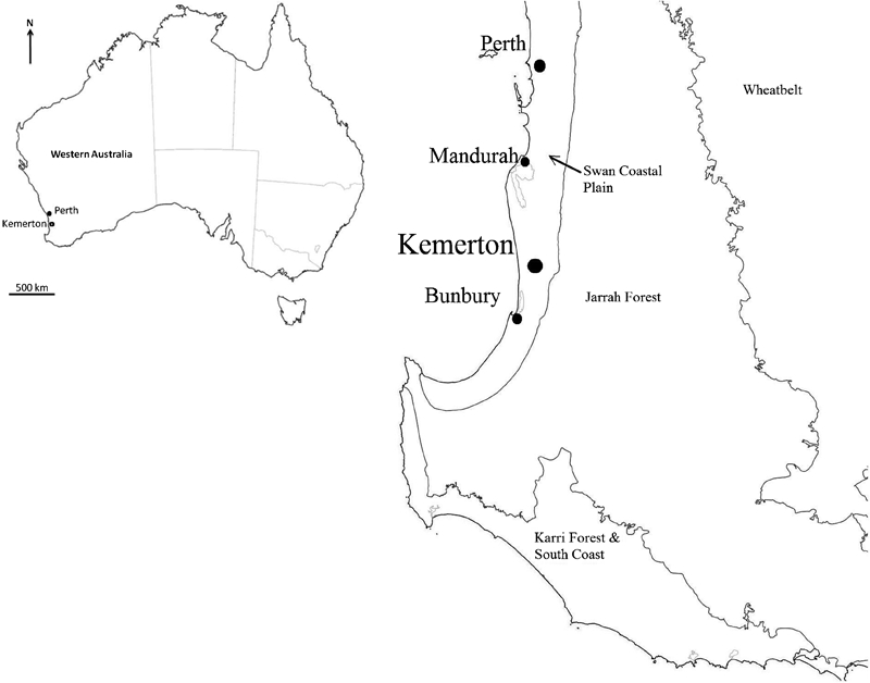
Location of Kemerton study area on Swan Coastal Plain of southwestern Australia
The climate is Mediterranean with most of the average ca. 890 mm of annual rainfall falling in winter and spring. Summers are warm to hot and typically very dry (average February maximum temperature of 28°C and rainfall of 13 mm), while winters are cool and wet (average July maximum 17°C and rainfall 186 mm). The rehabilitation and monitoring period 2001–2008 was one of the driest on record with total rainfall each year below the long term average, and most below the recent (1995–2008) average. In 2006, annual rainfall was very close to the lowest on record (510 mm).
Sands containing feldspar, silica and mineral sands (mostly titanium oxide) are extracted from below the water table using dredge ponds. The resource generally lies beneath <1 m of topsoil and 4–7 m of overburden (which generally contains a band of ferruginous cemented material at the interphase between high and low groundwater levels). The overburden is removed by earth moving equipment. The ore is then extracted from a superficial aquifer using a surface floating dredge to a maximum permitted depth of 15 m. Approximately 500 000 t of silica sands are extracted annually at this mine. Once ore extraction is complete, a series of pit lakes are created which, as they are essentially expressions of the groundwater, fill with permanent water up to ∼10 m deep with seasonal fluctuations. Fines, overburden and topsoil are available for sculpting and landscaping of the pit lake margins and slopes.
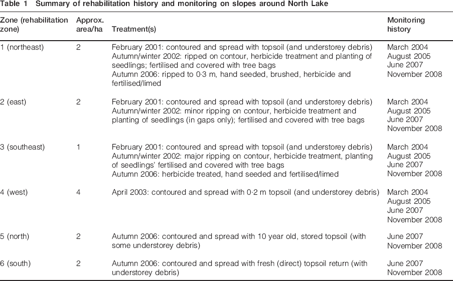
This study has focused on the main rehabilitation area around the northern most pit lake of the Kemerton active mining area, hereafter referred to as North Lake (Fig. 2). This area was mined and the pond created in the late 1990s. Rehabilitation of the surrounding slopes commenced in 2001 and progressively implemented until 2006 with different techniques used in different areas (called rehabilitation zones here). Full details of rehabilitation and monitoring techniques applied to each zone are summarised in Table 1. Rehabilitation of dredge ponds immediately south of North Lake commenced in 2007 and these also have been monitored.
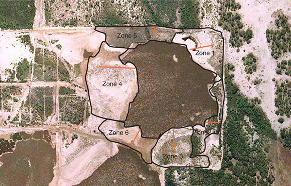
Aerial photograph from 2006 showing rehabilitation zones around North Lake: topsoil has been recently applied to zone 5 in photo; position of monitoring transects are shown; note that zone 6 has yet to be rehabilitated at this time
Summary of rehabilitation history and monitoring on slopes around North Lake
Monitoring
Monitoring commenced in March 2004 for zones rehabilitated in 2001–2003 and continued on a semiregular basis thereafter (Table 1). Monitoring used permanent transects established up the slope from the pit lake margin to the upper reaches of the rehabilitation. One or two transects, with random starting positions along the shore, were established in each zone and varied in length from 80 to 200 m. Along each transect, cover and abundance of all plant species were recorded in 2×2 m permanently marked quadrats set 5 m apart. Notes on plant health and size, including presence of any new seedlings were made.
Natural wetland and dampland communities within the active mine area were selected as suitable reference sites to compare with and evaluate rehabilitation. These were studied by the authors before assessment of rehabilitation (van Etten et al., 2011). Native plant communities of the study area were surveyed by recording plant species and their cover within plots placed in visually distinct vegetation types along transects running up slopes from wetland basin to uplands and including riparian zones. Topographic profiles were constructed for rehabilitation and natural wetlands using a theodolite and staff to measure relative height along transects.
Soil profile measurements were completed to help establish reasons for lack of plant growth across much of the rehabilitated sites. Different vegetation zones were identified along the permanent transects established in each rehabilitation zone. A sampling trench was then dug in each zone and the depth to different soil horizons to 50 cm was measured. A soil sample was then collected from each horizon. Soil samples were dried, ground and analysed in the laboratory for the following parameters: texture, colour, nitrate N (mg kg−1), ammonium N (mg kg−1), phosphate P (mg kg−1), potassium (mg kg−1), sulphur (mg kg−1), carbon (%), iron (mg kg−1), conductivity (dS cm−1) and pH. Soils were also sampled and analysed in similar fashion along transects through natural wetland communities (van Etten et al., 2011).
Data analysis
Data analysis involved calculating the mean and standard error of quadrat cover, density (number of plants per quadrat) and richness (number of species per quadrat) for each rehabilitation zone. The mean values of these parameters were then compared between zones and between monitoring periods using analyses of variance (ANOVA) or equivalent test depending on data (Table 2). Quadrats were used as the unit of replication for comparing zones. Analyses were conducted on perennial species only to enable fair comparison between monitoring periods given previous monitoring occurred over different seasons. Differences in species composition between zones (aggregated quadrat data) and between quadrats were explored using ordinations with site data from surveys of natural wetlands included to provide reference points. Ordination techniques attempt to arrange surveyed sites so that the degree of similarity in plant species composition is represented in the physical spacing of the sites when the data are plotted, i.e. similar sites sit close to one another. Differences between sites were then tested using ANOSIM which can be considered to be similar in principle to ANOVA for this type of analysis. Similarities were determined using the Bray–Curtis measure (based on square root transformed cover values of species). Ordination and ANOSIM were performed using the Primer (v6) software (Clarke and Warwick, 2001).
Statistical test results for vegetation attributes comparing different rehabilitation zones and year of establishment (as well as interaction between these two factors where possible)
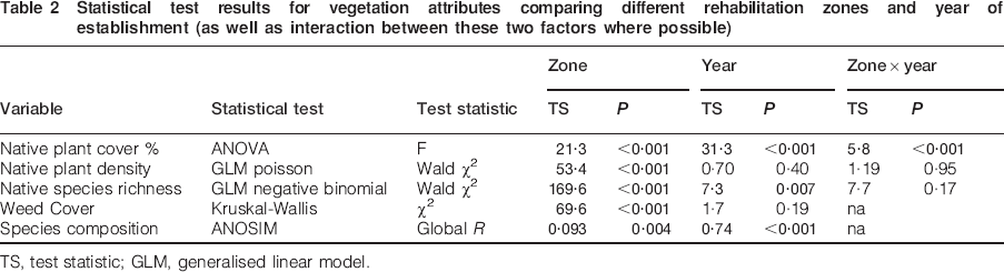
TS, test statistic; GLM, generalised linear model.
Results
Plant cover and abundance
Rehabilitation zones differed significantly from each other in terms of native species cover, weeds cover, native plant density, native species richness and species composition (Table 2, Fig. 3). Cover was consistently higher in zone 2 with total cover around 50% on average (Fig. 3a). This zone, although receiving the same initial topsoil treatment as other older rehabilitation (Table 1), was characterised by being lower in the profile (closer to groundwater) and on gentler slopes (Fig. 4). The two recently rehabilitated zones (5 and 6) had markedly increased in cover over time, with zone 5 (rehabilitated with stored topsoil) having an average cover of ∼42% which was greater than zone 6 (fresh topsoil, Fig. 3a). Overall cover across all zones increased over time, although the significant interaction between zone and time indicates that such increases were inconsistent across zones (Table 2). Older rehabilitated zones 1 and 3 had very low cover (<20%) over the 5 years of monitoring (Fig. 3a) despite receiving remedial treatments such as planting, seeding, fertilisation and weed control (Table 1).
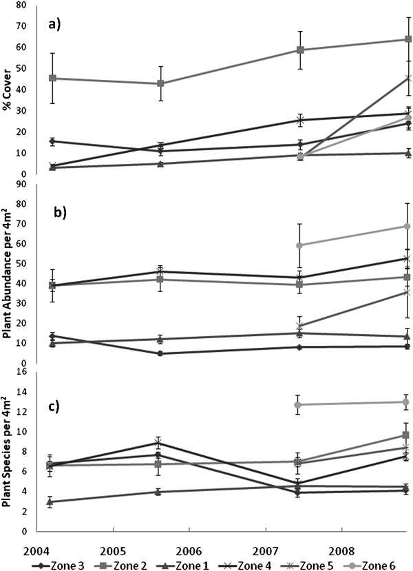
Trends in mean values (with ±standard error bars) over time of a native plant cover, b native plant density and c native plant species richness per quadrat for six rehabilitation zones
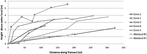
Topographic profiles showing height above lake water level (winter 2007) for selected monitoring transects placed perpendicular to contour; for natural wetland profiles, 0 m height was taken at lowest point of lake bed
Native plant density remained relatively stable over time but differed between zones (Table 2). Zone 6, the most recently rehabilitated with fresh topsoil, had the greatest numbers of plants, while zones 1 and 3 had few plants persisting (Fig. 3b). Species richness followed a similar pattern with zone 6 having far greater richness (average of 13 native plant species per quadrat) than other zones (Table 2, Fig. 3c). There were improvements in species richness from 2008 to 2009 (Table 2), although zones 3 and 4 clearly lost species between 2005 and 2007 (Fig. 3c).
Comparisons to native vegetation
Wetland vegetation was divided into fringing (i.e. flooded), riparian (waterlogged) and wetland–upland ecotone zones (Fig. 5a). Plant species composition of rehabilitation (when collated for each zone) was dissimilar to riparian vegetation of natural wetlands (ANOSIM Global R = 0·67, p = 0·002) and other local vegetation types (p<0001, Fig. 5a). The closest rehabilitation to the natural wetlands in terms of floristics was zone 2 which most closely resembled the riparian vegetation of local wetlands, although the two most recent rehabilitation efforts (zones 5 and 6) showed the largest shift in species composition from 2007 to 2008, becoming more similar to riparian communities in general. The differences between the rehabilitation and natural wetlands were predominantly in tree species Melaleuca viminalis and M. rhaphiophylla (which had greater average abundance in natural wetlands), dominant sedges such as Lepidosperma longitudinale and Meeboldina scariosa (greater abundance in natural wetlands, although locally common in rehabilitation), leguminous shrubs such as Viminaria juncea and Acacia pulchella (greater abundance in rehabilitation), and shrubs from Myrtaceae family such as Hypocalymma angustifolium and Kunzea spp. (greater abundance in rehabilitation). Together such species account for 68% of the difference in composition between rehabilitation and natural wetland riparian zones (Table 3).
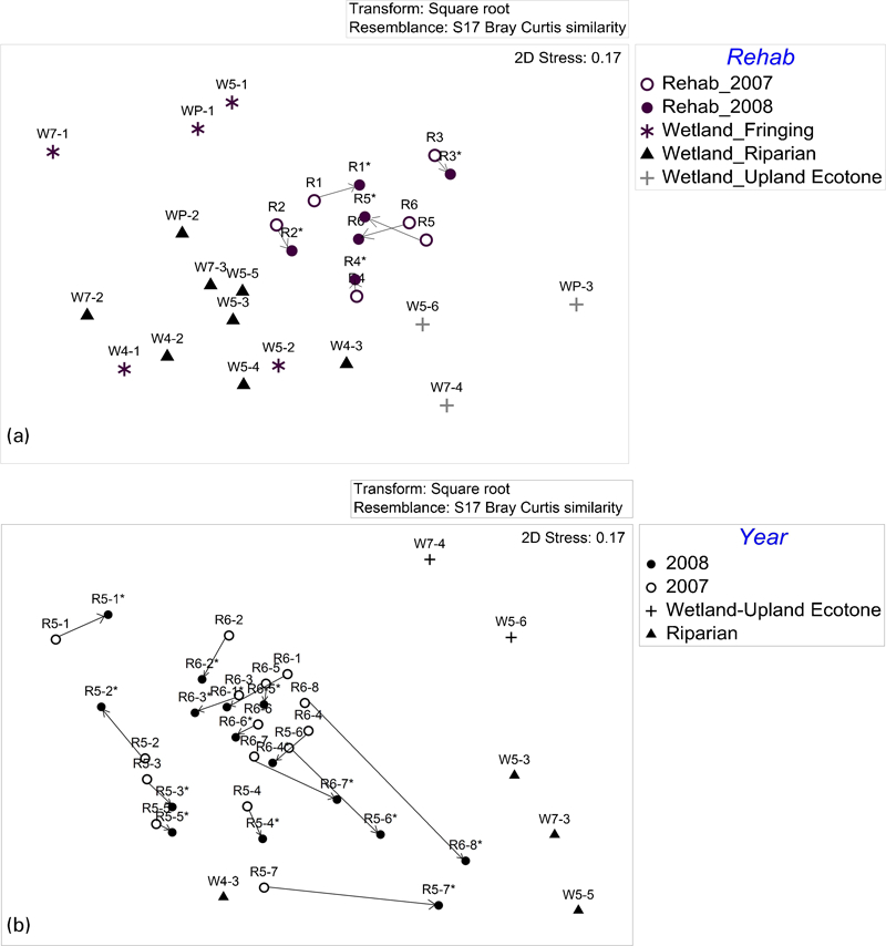
Ordinations of floristic data using multidimensional scaling for a monitoring transects in rehabilitation (R1 to R6; with number indicating zone) at two monitoring dates (2007 and 2008*), and wetland sites (Wx–y, where x indicates wetland and y refers to point along transect across wetland from lake basin (lowest number) to wetland–upland ecotone (highest number); and b monitoring quadrats for most recent rehabilitation (R5 and R6 with second number referring to position of quadrat along transect with lowest number being highest point) over two monitoring dates with reference sites located in nearby natural wetlands (wetland numbering as per a above): arrows show trajectory of floristic change between monitoring dates; floristic data used to generate similarity measures were square root transformed cover of perennial plant species
Differences between rehabilitation and natural wetland transects in species composition as determined using SIMPER analysis of dissimilarity in PRIMER* (Clarke and Warwick, 2001)
Abundance refers to mean squared root transformed cover; dissimilarity refers to average contribution of species to average Bray–Curtis dissimilarity between rehab and wetlands.
Shifts in species composition
Zones differed from each other in plant species composition measured at the quadrat level, and shifted in composition over time (Table 2, Fig. 5b); pairwise tests using ANOSIM showed each zone differed to all others (p<0·01). Species composition also varied with position along transects from lake edge to upland; such gradual change is evident along transects placed through the two recently rehabilitated zones just 1–2 years after topsoil treatment (Fig. 5b). These two zones showed significant differences in floristics between upper (upland), middle (riparian) and lower (fringing) zones of transects (Global R = 0·32, p<0·001), as well as significant shifts between 2007 and 2008 (Global R = 0·19, p = 0·003). A substantial increase in emergent sedges/rushes and a decline of legumes was the main temporal change in composition within the fringing zone (Appendix 1). In contrast, the major shifts in composition of uplands were increases in cover of Myrtaceae and leguminous shrubs and decreases in typical fringing sedge/rush species. Riparian (middle zone) floristic changes were mainly attributable to increases in shrub abundances. In terms of resemblance to native plant communities, lower parts of recent rehabilitation resembled the fringing vegetation of natural wetlands, and showed the greatest degree of change in composition over time (Fig. 5b). In contrast, riparian parts of the recent rehabilitation had changed relatively little and were if anything shifting closer to natural dampland (site W4-3). Upper parts of rehabilitation showed relatively substantial changes in floristics but were not always becoming more similar to wetland–upland ecotones (Fig. 5b), although they contained many understorey species of uplands (Appendix 1).
Topography and soil
Topographic profiles (Fig. 4) show that zone 2 was generally the lowest in the landscape with the most gentle slopes and was most similar to natural wetlands studied. In contrast, zones 1 and 3 rose rapidly from the lake edge with the majority of transects 3 m or more above water level at time of measurement. The most recent rehabilitation (zones 5 and 6) were intermediate in topography with relatively gradual and consistent slopes (but steeper than profiles of local wetlands studied).
Chemical and physical characteristics of soil samples collected at each visually identifiable soil horizon within each rehabilitation zone are shown in Appendix 2. Rehabilitated soils were generally grey coloured and fine textured (1·5 mm grain size) with concentrations of organic carbon under 2%, unlike wetland soils with 3–6% carbon and dark grey to brown in colour. Mean soil pH of rehabilitated areas was also under 5, while wetlands soils were above pH 6. Soil pH was mildly to strongly acidic in rehabilitation, but generally in line with variation seen in natural wetland substrates (Appendix 2). With one or two exceptions, rehabilitation soils were very low in nutrients with levels of nitrate and phosphate levels likely to be below the limits of detection at most sites (i.e. <1 ppm). In contrast, levels of macronutrients in natural wetland soils were at least several times higher, on average, than that of rehabilitation (Appendix 2). Conductivity, an indicator of soil salinity, was generally lower in rehabilitated areas (Appendix 2).
There were some distinct exceptions to these general trends. Topsoil (first 32 cm) of zone 3 was quite high in nitrogen in the form of ammonium. This zone also has high organic carbon. This is not surprising given the high plant density and surface leaf litter cover in this area. Organic carbon was also relatively high in the newly rehabilitated areas, although it was somewhat higher at zone 6 (where fresh topsoil was used) compared to zone 5 (old, stored topsoil). However, both these sites are low in available macronutrients (Appendix 2).
Discussion
Rehabilitation performance
The key finding in this study was the marked variation in vegetation cover and plant species diversity within and between rehabilitation zones. Some areas are clearly meeting more immediate targets for rehabilitation, being diverse in native plant species and life forms, as well as being structurally complex and dense. These areas also seem to be on target to meet longer term restoration objectives as they are becoming increasingly similar to local natural wetland communities in terms of species composition and soil. This suggests that the use of topsoil as a restoration technique can work and has considerable potential to successfully restore margins and slopes of pit lakes formed following sand mining on the Swan Coastal Plain. These more successfully restored areas were generally in the fringing zone and in some riparian areas, with uplands generally being largely unsuccessful in terms of restoration outcomes (Fig. 6). The reasons for these differences across the post-mining landscape are explored below.
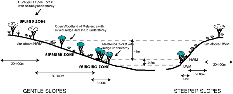
Recommended rehabilitation zoning for restoration of wetlands (particularly pit lakes) which are linked to groundwater systems (note 1: vertical heights are largely dependent on relative lake and groundwater depth and degree of fluctuation, with figures here applicable to pit lake studied at Kemerton; note 2: horizontal distances depend largely on slope of reformed land; note 3: vertical height exaggerated relative to horizontal distance)
Fringing zone
Margins of pit lakes are typically the most difficult post-mining landforms to restore and are often devoid of vegetation (van Etten, 2011). Conversely, the most successful restoration sites in our study area were fringing zones where dense sedgeland of species such as Lepidosperma longitudinale, Juncus spp. (Juncaceae), Isolepis spp., Baumea articulata and Meeboldina scariosa (Restionaceae) have developed (although characteristic woody vegetation was largely absent), and this supports other studies demonstrating the utility of using topsoil in wetland environments (Brown and Bedford, 1997; Wilcox and Whillans, 1999). However, there are practical considerations which need to be heeded when using topsoil in the fringing zone. First, topsoil can only be feasibly applied in the dry season or other times of low water levels. Rising water levels may cause chemical and other changes to the topsoil as well erosion, especially on slightly steeper slopes and or where wave action is prevalent (Wilcox and Whillans, 1999). Stabilisation of wetland edges may be required by means of plant material (logs, brushing), sandbags, or matting (Wilcox and Whillans, 1999; Nishihoro et al., 2006).
Several studies have demonstrated the accumulation of plants and species via wind dispersed seed in this zone (e.g. van der Valk et al., 1999) and problems can occur when this zone becomes dominated by exotic and/or other ruderal species (Brown and Bedford, 1997). Some of the genera colonising the fringing zone of the pit lake are known to produce abundant wind dispersed seed (e.g. Juncus spp., Bakker et al., 1996; Meeboldina spp., Meney and Pate, 1999) although the dominant species in this zone (L. longitudinale) is likely to have arisen from topsoil given its widespread emergence soon after topsoil treatment and its ant dispersed, dormant seed (Kodym et al., 2010; Lengyel et al., 2010). Last, consideration needs to be given to acute hydroperiod gradients across the fringing zone with plant species composition known to be sensitive to any variations in microtopography (Naiman et al., 2005; Nishihoro et al., 2006). Overall, we found rehabilitation of wetland fringing zones considerably easier to achieve than the surrounding riparian slopes and uplands.
Riparian zone
The riparian zone around the main rehabilitated pit lake generally lacked the Melaleuca trees and other woody species which characterise the riparian zone of local natural wetlands (Fig. 6). However, where slopes were relatively gentle, a healthy stand of Melaleuca and associated species did develop. Presumably such success in these areas is linked to their topographic and hydrological similarity with natural wetlands of the area which also develop on subtle slopes (van Etten et al., 2011), as well as the increased expanse of this zone where slopes are subtle (Fig. 6). This pattern was also found in the more recently rehabilitated area south of the main pit lake where subtle and undulating slopes were reformed after mining with large numbers of smaller and shallower ponds between; here a relatively large number of Melaleuca seedlings were found on the slightly raised ground above the ponds. Woody debris was scattered over this area, with some of the Melaleuca re-establishing via suckering (resprouting) from root systems persisting in or on the surface of the topsoil. The same had been noted around the margin of the main pit lake, albeit at a lower density. Therefore, the incorporation of woody debris, particularly root systems, in the topsoil could well be an innovative approach to improve restoration outcomes in riparian zones, and further experimentation with the technique is recommended.
Terrestrial zones
The older rehabilitated upland sites more than 2 m above the lake water levels were mostly unsuccessful with low native species diversity, considerable weed cover and few to no woody plants (Fig. 6). They were also markedly dissimilar to native plant communities in the vicinity, including eucalypt woodlands and forests which characterise the terrestrial vegetation of the study area. The more recently rehabilitated areas were considerably richer in native species, but there was evidence that upland areas (again those above 2 m) were declining in terms of diversity and may, over time, begin to resemble the older unsuccessful rehabilitated areas. Reasons for this decline and general shifts in species composition are discussed below.
Best practice for using topsoil as restoration tool
This study supports generally accepted best practice for restoration of disturbed land using topsoil. Specifically, we demonstrated superior numbers of native species and plant density in areas treated with fresh topsoil compared to where applied topsoil had been stored for several years. Superior plant establishment using fresh topsoil has been shown elsewhere (Dickie et al., 1988; Bellairs and Bell, 1993; Milton, 2001; Parrotta and Knowles, 2001). Rokich et al. (2000) reported that mean seedling numbers and species richness emerging from three year old topsoil was only 34 and 61% respectively, of that recorded in areas where fresh topsoil was applied for a rehabilitated Banksia woodland following sand mining near Perth; this is broadly the same geomorphic unit as our study (albeit their study was restricted to uplands). The decline in seedling emergence from topsoil following storage is generally attributed to loss of seed viability over time, although others point to the role of seed damage when placed in large piles, early germination when piles are kept moist, or to dilution effects when surface layers containing most seeds are mixed with deeper layers (van der Valk and Pederson, 1989; Rokich et al., 2000; Scoles–Sciulla and DeFalco, 2009). Van der Valk et al. (1999) showed that seed of several Carex spp. (sedges) did not germinate when older than 6 months and recommended fresh topsoil for fringing wetland restoration.
Burke (2008) highlighted the difficulty in knowing whether seedling recruitment from applied topsoil originates from stored seed or seed dispersed into the soil after topsoil application via wind, animal or water. In this study, the original rehabilitation sites were not monitored until three years after topsoil treatment and therefore the relative roles of soil seed bank versus seed dispersal cannot be clearly differentiated in these areas. However, the most recent rehabilitation was first monitored one year post-treatment, and here seedling emergence could be confidently attributed to seed stored in topsoil given the relative even spread of plants and lack of seedlings where topsoil was not applied. Furthermore the relatively large size and/or hardness of seeds for many emergent species (e.g. legumes; Bell et al., 1993) suggest that they emerged from topsoil. We also recorded reasonable germination in the second year after topsoil treatment; again this is mostly attributable to soil seed bank as it mainly involved species with pronounced innate seed dormancy (Bell et al., 1993). Much of the older rehabilitation areas had high weed cover (mostly grasses and other ruderals) and seed of these species may have accumulated in the topsoil during stockpiling as has been reported elsewhere (Dickie et al., 1988; Rokich et al., 2000). However, given weed cover has been increasing and dominated where native plant cover was low, it is likely that much of the weed problem can be attributed to wind blown seed arriving after topsoil application.
Effectiveness of remedial treatments
Large areas of rehabilitation are in depauperate condition and have not improved for several years with persistent low cover (mostly <15%) and low diversity of native plants despite a number of corrective restoration treatments being applied during this time (including planting of seedlings, ripping, fertilising, herbicide and direct seeding). We conclude that such remedial actions appear to have been largely forlorn and, in the case of ripping the surface soil, may have even had a negative impact on plant cover and species diversity. This highlights the importance of getting the site treatments and revegetation prescriptions right, as best as possible, in the initial phase (e.g. just after landforming in a post-mine context) as follow-up treatments become more difficult and expensive with time, especially where there is already some recovery of plant cover (Koch, 2007).
Matching of topsoil source and receiving sites
Poor and seemingly intractable rehabilitation areas were in stark contrast to the most successful rehabilitation (zone 2) which was also treated with topsoil at the same time as these poor sites. Zone 2 had developed structure and species composition similar to that of riparian zones of many local wetlands. Its main distinction from poor rehabilitation was its lower position in the landscape being within 2 m (vertically) of the mean water level of the pit lakes and consequently more likely to remain moist to waterlogged throughout the year. Poor zones were mostly >2 m above pit lake water levels and have mostly dry sandy soils. The fringing vegetation of these zones was generally performing better with dense sedgeland, except on the east side where wave action actively eroded the littoral edge creating small highwalls. We therefore conclude that site factors, specifically height above groundwater levels, are also likely to play a critical role in restoration success. Further, we hypothesise that a major reason for lack of restoration success within our study area can be attributed to inappropriate matching of topsoil source to receiving sites given topsoil has been routinely collected from natural wetlands, particularly damplands. These topsoils have failed to develop adequate plant cover and diversity when applied to higher parts of the landscape which, in terms of the physical environment, are more similar to uplands of the region. We have not found similar results in the literature regarding lack of success of wetland soils when applied to uplands, although Brown and Bedford (1997) reported superior long term development of wetland vegetation occurred where wetland topsoil was applied compared to where topsoil was sourced from uplands. Nishihiro et al. (2006) also demonstrated that topsoil origin significantly affected species composition of re-established vegetation in a degraded Japanese wetland.
Based on these findings, we suggest that topsoil be separated based on topographical position and/or vegetation type of source locality, but recommend controlled experiments to assess relative performance of topsoil source when applied to particular post-mine landforms. Specifically, we advocate keeping topsoil collected from uplands, riparian and fringing vegetation in separate piles and then applied to similar areas in reformed landscapes as much as practicable (Fig. 6). For the restored pit lakes of our study, we recommend that ∼2 m above mean water level be used to broadly demarcate upland and riparian zones (based on our findings and observations), although more generally this boundary will be influenced by such factors as hydroperiod, degree of hydraulic conductivity and groundwater connectedness, as well as long term trends in groundwater levels (Bedford, 1996). We also recommend that more gradual slopes be constructed where possible to:
maximise the extent of land suited to the development of riparian wetland vegetation (Fig. 6) given this is the predominant vegetation being mined and for which topsoil is therefore available
prevent erosion of fringing zones
more closely mimic the gentle topography of natural wetlands of the district.
We have demonstrated shifting plant species composition within rehabilitation, albeit over a relatively short time period. Given topsoil was sourced from a relatively homogeneous area and applied uniformly over slopes, some preferential establishment is likely to have occurred given gradients in species composition were evident after one year within the most recently rehabilitated zones. Other authors have reported differential establishment of species from applied topsoil in response to variations in the physical environment, particularly topography (Cobbaert et al., 2004; Nishihoro et al., 2006; Burke, 2008). We found that these gradients developed further over the second year post-rehabilitation, due predominantly to loss of wetland species and increased cover of typical upland species on upper parts of the topographic profile; the reverse trend was found in the seasonally flooded fringing zone. Therefore, there is evidence that species are sorting into preferred habitats to some degree and this would be expected to develop further over time. However, as temporal shifts seem to be mainly driven by changes in species dominance, rather than species migration, broad separation and application of topsoil is advocated to improve restoration success.
Conclusions
Although not set up as a controlled field experiment, our study has shown that repeated monitoring of rehabilitation can reveal valuable insights into the factors likely to contribute to successful restoration of post-mining landscapes. This is particularly so where rehabilitation is compared to appropriately chosen reference or analogue sites (White and Walker, 1997). From our study we tentatively recommend the following prescriptions for pit lake margins and slopes of the study area, and as potential general approaches to improve restoration success elsewhere: use topsoil as the main method for restoration; direct return or apply fresh topsoil where possible; broadly segregated topsoils based on physical characteristics of collection locality applied to similar areas around lakes; and create gentle slopes and shallow wetlands which more closely resemble that of natural wetlands of the region.
We recognise the limitations in using post hoc monitoring data to determine the effects of restoration treatments, and recommend that suggested treatments identified in this study be viewed as hypotheses to be tested using replicated and controlled experiments in future research.
Footnotes
Acknowledgements
We thank Kemerton Silica Sands P/L for funding the research and, in particular, Mark Gell, former Resident Manager, for his vision in initiating and supporting this project. Anonymous referees are also thanked for useful comments which have improved this manuscript.